Integration of Analytic Hierarchy Process (AHP) and Remote Sensing to Assess Threats to Preservation of the Oases: Case of Al Ain, UAE
Abstract
1. Introduction
2. Methodology
2.1. Study Area
2.2. Analytic Hierarchy Process (AHP)
2.3. Land Use and Land Cover Change
2.4. Oases Stress
3. Results
3.1. Survey Analysis
3.2. LULC Change
3.3. Oases Stress
4. Discussion
5. Conclusions
6. Recommendations
- Effective groundwater management: Given that groundwater consumption in the agricultural sector accounts for a substantial portion of water usage, it is crucial to implement effective policies and regulations for managing groundwater. This should include controlling water extraction, monitoring groundwater levels, and addressing issues such as salinity and pollution.
- Gray water for irrigation and smart irrigation systems: To mitigate irrigation water shortages and reduce the burden on farmers, alternative water sources like gray water can be assessed for irrigation purposes. Additionally, the adoption of smart irrigation systems based on the Internet of Things (IoT) can help optimize water consumption by providing precise irrigation based on plant needs. These measures can contribute to more efficient water use and reduce the strain on oases.
- Soil improvement practices: Given the threat of soil salinity to oases, implementing soil improvement practices is essential. Strategies such as minimizing saltwater during irrigation, planting deep-rooted and salt-tolerant crops, using mulch or crop residue to reduce evaporation, and adding organic matter to enhance soil fertility can help reduce soil salinity and promote healthy plant growth.
- Palm disease management: The invasive red palm weevil (RPW) poses a significant threat to date palms within oases. Early detection and containment measures are crucial for the sustainable preservation of oases. Combining visual inspection with remote sensing technologies can improve the efficiency and effectiveness of RPW detection, allowing for early intervention and control measures to be implemented.
- Future research: This study highlights the environmental and economic services provided by oases. Further research can explore the potential economic benefits of oases, such as eco-tourism, sustainable agriculture, and ecosystem services. Understanding the value of oases beyond their cultural significance can contribute to the development of comprehensive preservation strategies.
Supplementary Materials
Author Contributions
Funding
Informed Consent Statement
Data Availability Statement
Acknowledgments
Conflicts of Interest
References
- Veillon, R. State of Conservation of World Heritage Properties: A Statistical Analysis (1979–2013); UNESCO World Heritage Centre: Paris, France, 2014. [Google Scholar]
- SDG. Biodiversity and Ecosystems. 2022. Available online: https://sdgs.un.org/topics/biodiversity-and-ecosystems (accessed on 12 January 2023).
- UN. The Sustainable Development Agenda. 2022. Available online: https://www.un.org/sustainabledevelopment/development-agenda/ (accessed on 15 May 2022).
- FAO. Adaptive Management and Monitoring of Oasis Eco-Systems in the Maghreb. 2017. Available online: https://www.fao.org/neareast/news/view/en/c/1072400/ (accessed on 11 May 2022).
- Petersen, A. Islamic urbanism in Eastern Arabia: The case of the al-Ayn-al-Buraymī oasis. Proc. Semin. Arab. Stud. Lond. 2009, 39, 61–74. Available online: https://www.jstor.org/stable/41223990 (accessed on 13 February 2023).
- UNESCO World Heritage Convention. United Arab Emirates. 2022. Available online: https://whc.unesco.org/en/statesparties/ae (accessed on 12 September 2022).
- Al-Tikriti, W.Y. An early Islamic Falaj from al-Ain, UAE. Bull. Soc. Arab. Stud. 2003, 8, 11–19. [Google Scholar]
- Power, T.C.; Sheehan, P.D. The origin and development of the oasis landscape of al-Ain (UAE). Proc. Semin. Arab. Stud. 2013, 42, 291–308. Available online: https://www.jstor.org/stable/41623644 (accessed on 3 February 2023).
- Power, T.C.; Sheehan, P.D. The Bayt Bin Ātī in Qattärah Oasis: A prehistoric industrial site and the formation of the oasis landscape of al-Ayn, UAE. Proc. Semin. Arab. Stud. 2011, 41, 267–282. Available online: https://www.jstor.org/stable/41622139 (accessed on 10 February 2023).
- FAO. Al Ain and Liwa Historical Date Palm Oases, United Arab Emirates. 2023. Available online: https://www.fao.org/giahs/giahsaroundtheworld/designated-sites/near-east-and-north-africa/al-ain-and-liwa-historical-date-palm-oases/en/ (accessed on 10 August 2022).
- Allali, K.; Fadlaoui, A.; Arib, F.; de-Miguel, M.D.; Alcon, F. Economic valuation of cultural services at the Todgha Oasis, Morocco. J. Nat. Conserv. 2023, 73, 126371. [Google Scholar] [CrossRef]
- Yagoub, M.M. Monitoring of urban growth of a desert city through remote sensing: Al-Ain (UAE) between 1976 and 2000. Int. J. Remote Sens. 2004, 25, 1063–1076. [Google Scholar] [CrossRef]
- Al Foah. Taking UAE’s Rich Heritage Global. 2023. Available online: https://alfoah.com/ (accessed on 15 February 2023).
- Siddiq, M.; Aleid; Salah, M.; Kader, A.A. Dates: Postharvest Science, Processing Technology and Health Benefits; John Wiley & Sons Ltd.: Chichester, UK, 2013. [Google Scholar]
- Jaiswal, N.; Deb, S.K.; Panda, S.K.; Mandal, A.K.; Khan, A.W.; Kishtawal, C.M. Investigating Intra-Urban thermal variability of Ahmedabad, India: Heat wave prediction perspective. J. Indian Soc. Remote Sens. 2022, 50, 1903–1913. [Google Scholar] [CrossRef]
- Yagoub, M.M.; Tesfaldet, Y.T.; Elmubarak, M.G.; Al Hosani, N. Extraction of Urban Quality of Life Indicators Using Remote Sensing and Machine Learning: The Case of Al Ain City, United Arab Emirates (UAE). ISPRS Int. J. Geo-Inf. 2022, 11, 458. [Google Scholar] [CrossRef]
- Al Shaiba, O.M. Creation and Use of a GeoDatabase in the Study of the Oases of Jimi and Quattra in Al Ain; A Capstone Report; United Arab Emirates University: Abu Dhabi, United Arab Emirates, 2011. [Google Scholar]
- Bousdira, K.; Nouri, L.H.; Legrand, J. Chemical characterization of phoenicicole biomass fuel in algerian oasis: Deglet Nour and Ghars cultivars case. Energy Fuels 2014, 28, 7483–7493. [Google Scholar] [CrossRef]
- Prost, G.L. Remote Sensing for Geoscientists: Image Analysis and Integration, 3rd ed.; CRC Press: London, UK, 2019. [Google Scholar]
- Ge, G.; Zhang, J.; Chen, X.; Liu, X.; Hao, Y.; Yang, X.; Kwon, S.M. Effects of Land Use and Land Cover Change on Ecosystem Services in an Arid Desert-Oasis Ecotone along the Yellow River of China. Ecol. Eng. 2022, 176, 106512. [Google Scholar] [CrossRef]
- Salih, A.; Hassaballa, A.A.; Ganawa, E. Mapping Desertification Degree and Assessing Its Severity in Al-Ahsa Oasis, Saudi Arabia, Using Remote Sensing-Based Indicators. Arab. J. Geosci. 2021, 14, 192. [Google Scholar] [CrossRef]
- Ullah, S.; Shi, Y.; Dasti, M.Y.S.; Wajid, M.; Saqib, Z.A. Estimating Advance of Built-Up Area in Desert-Oasis Ecotone of Cholistan Desert Using Landsat. Land 2023, 12, 1009. [Google Scholar] [CrossRef]
- Maimaitiaili, A.; Aji, X.; Matniyaz, A.; Kondoh, A. Monitoring and analysing land use/cover changes in an arid region based on multi-satellite data: The Kashgar Region, Northwest China. Land 2018, 7, 6. [Google Scholar] [CrossRef]
- Moumane, A.; Al Karkouri, J.; Benmansour, A.; El Ghazali, F.E.; Fico, J.; Karmaoui, A.; Batchi, M. Monitoring long-term land use, land cover change, and desertification in the Ternata oasis, Middle Draa Valley, Morocco. Remote Sens. Appl. Soc. Environ. 2022, 26, 100745. [Google Scholar] [CrossRef]
- Zhang, Q.; Luo, G.; Li, L.; Zhang, M.; Lv, N.; Wang, X. An analysis of oasis evolution based on land use and land cover change: A case study in the Sangong River Basin on the northern slope of the Tianshan Mountains. J. Geogr. Sci. 2017, 27, 223–239. [Google Scholar] [CrossRef]
- UNESCO World Heritage Convention. State of Conservation Information System (SOC): Conserve and Transmit to Future Generations. 2022. Available online: https://whc.unesco.org/en/soc/ (accessed on 10 September 2022).
- Statistics Centre. Statistical Yearbook of Abu Dhabi 2020; Statistics Center Publication: Abu Dhabi, United Arab Emirates, 2020. [Google Scholar]
- Yildirim, E.; El-Masri, S. Master Planning for Conservation in Al Ain Oasis. In Proceedings of the 46th ISOCARP Congress, Nairobi, Kenya, 19–23 September 2010. [Google Scholar]
- Power, T.; Sheehan, P.; Al Dhaheri, S.M.; Al Hammadi, M.A.A.A.; Al Hammadi, K.I.; Al Noaimi, A.A.; Al Subaihi, A.M.; Al Omar, H.H.; Al-Romeithi, F.T.; Al Mansoori, M.K.; et al. Al Ain Oases Mapping Project: Qattarah Oasis, past and present (poster). Proc. Semin. Arab. Stud. 2016, 46, 227–236. Available online: https://www.jstor.org/stable/45163429 (accessed on 11 March 2023).
- Khalifa, A. Khalifa International Award for Date Palm and Agricultural Innovation. 2023. Available online: https://www.kiaai.ae/en (accessed on 5 November 2022).
- Saaty, T.L. How to make a decision: The Analytic Hierarchy Process. Eur. J. Oper. Res. 1990, 48, 9–26. [Google Scholar] [CrossRef]
- Passage Technology. What is the Analytic Hierarchy Process (AHP)?|Passage Technology. Passage Technology. 2023. Available online: https://www.passagetechnology.com/what-is-the-analytic-hierarchy-process (accessed on 10 March 2023).
- Agapiou, A.; Lysandrou, V.; Alexakis, D.D.; Themistocleous, K.; Cuca, B.; Argyriou, A.; Hadjimitsis, D.G. Cultural heritage management and monitoring using remote sensing data and GIS: The case study of Paphos area, Cyprus. Comput. Environ. Urban Syst 2015, 54, 230–239. [Google Scholar] [CrossRef]
- Kittipongvises, S.; Phetrak, A.; Rattanapun, P.; Brundiers, K.; Buizer, J.L.; Melnick, R. AHP-GIS analysis for flood hazard assessment of the communities nearby the world heritage site on Ayutthaya Island, Thailand. Int. J. Disaster Risk Reduct. 2020, 48, 101612. [Google Scholar] [CrossRef]
- Kutut, V.; Zavadskas, E.K.; Lazauskas, M. Assessment of priority alternatives for preservation of historic buildings using model based on ARAS and AHP methods. Arch. Civ. Mech. Eng. 2014, 14, 287–294. [Google Scholar] [CrossRef]
- Daim, T.U.; Udbye, A.; Balasubramanian, A. Use of analytic hierarchy process (AHP) for selection of 3PL providers. J. Manuf. Technol. Manag. 2013, 24, 28–51. [Google Scholar] [CrossRef]
- Saaty, T.L. The Analytic Hierarchy Process: Planning, Priority Setting, Resource Allocation; McGraw-Hill International Book Co.: New York, NY, USA, 1980. [Google Scholar]
- Sheykhmousa, M.; Mahdianpari, M.; Ghanbari, H.; Mohammadimanesh, F.; Ghamisi, P.; Homayouni, S. Support Vector Machine Versus Random Forest for Remote Sensing Image Classification: A Meta-Analysis and Systematic Review. IEEE J. Sel. Top. Appl. Earth Obs. Remote Sens. 2020, 13, 6308–6325. [Google Scholar] [CrossRef]
- Shi, T.; Huang, Y.; Wang, H.; Shi, C.-E.; Yang, Y.-J. Influence of urbanization on the thermal environment of meteorological station: Satellite-observed evidence. Adv. Clim. Chang. Res. 2015, 6, 7–15. [Google Scholar] [CrossRef]
- EOS. Soil Salinization Causes & How to Prevent and Manage It. 2023. Available online: https://eos.com/blog/soil-salinization/ (accessed on 12 June 2022).
- Gu, Y.; Hunt, E.; Wardlow, B.; Basara, J.B.; Brown, J.F.; Verdin, J.P. Evaluation of MODIS NDVI and NDWI for vegetation drought monitoring using Oklahoma Mesonet soil moisture data. Geophys. Res. Lett. 2008, 35. [Google Scholar] [CrossRef]
- EDO. NDWI: Normalized Difference Water Index; EDO Home—European Drought Observatory—JRC European Commission: 2011. Available online: www.europa.eu (accessed on 15 January 2023).
- Huang, S.; Tang, L.; Hupy, J.P.; Wang, Y.; Shao, G.F. A commentary review on the use of normalized difference vegetation index (NDVI) in the era of popular remote sensing. J. For. Res. 2021, 32, 2719. [Google Scholar] [CrossRef]
- Gao, B.-C. NDWI—A normalized difference water index for remote sensing of vegetation liquid water from space. Remote Sens. Environ. 1996, 58, 257–266. [Google Scholar] [CrossRef]
- Zhang, T.; Su, J.; Liu, C.; Chen, W.H.; Liu, H.; Liu, G. Band selection in sentinel-2 satellite for agriculture applications. In Proceedings of the 23rd International Conference on Automation and Computing (ICAC), Huddersfield, UK, 7–8 September 2017; IEEE: Piscataway, NJ, USA, 2017; pp. 1–6. [Google Scholar] [CrossRef]
- Cabrera, J.S.; Lee, H.S. Flood risk assessment for Davao Oriental in the Philippines using Geographic Information system-based multi-criteria analysis and the maximum entropy model. J. Flood Risk Manag. 2020, 13, e12607. [Google Scholar] [CrossRef]
- Santoro, A. Traditional oases in Northern Africa as multifunctional agroforestry systems: A systematic literature review of the provided Ecosystem Services and of the main vulnerabilities. Agroforest Syst. 2022, 97, 81–96. [Google Scholar] [CrossRef]
- Wright, G.C. The Date Industry in the United States and Mexico. The Blessed Tree, 14 (01)–March 2022. Available online: https://www.kiaai.ae/sites/default/files/magazine_pdf_files/books_BlessedTreeIssueMarch2022_2022-03-01_7626733.pdf (accessed on 20 April 2023).
- Foody, G.M. Status of land cover classification accuracy assessment. Remote Sens. Environ. 2002, 80, 185–201. [Google Scholar] [CrossRef]
- Thomlinson, J.R.; Bolstad, P.V.; Cohen, W.B. Coordinating Methodologies for Scaling Landcover Classifications from Site-Specific to Global. Remote Sens. Environ. 1999, 70, 16–28. [Google Scholar] [CrossRef]
- Salloum, H. How Sheikh Zayid Turned the Desert Green. Christian Science Monitor, 27 May 1997. Available online: https://www.csmonitor.com/1997/0527/052797.opin.opin.1.html (accessed on 12 April 2023).
- NCM. Annual Climate Assessment 2021. United Arab Emirates. 2021. Available online: https://www.ncm.ae/resources/climate-reports/ncm-annual-climate-assessment-2021-s.pdf (accessed on 8 October 2022).
- Lamqadem, A.A.; Saber, H.; Pradhan, B. Quantitative assessment of desertification in an arid oasis using remote sensing data and spectral index techniques. Remote Sens. 2018, 10, 1862. [Google Scholar] [CrossRef]
- Liu, Y.; Song, W.; Deng, X. Understanding the spatiotemporal variation of urban land expansion in oasis cities by integrating remote sensing and multi-dimensional DPSIR-based indicators. Ecol. Indic. 2019, 96, 23–37. [Google Scholar] [CrossRef]
- Murad, A. An overview of conventional and non-conventional water resources in arid region: Assessment and constrains of the United Arab Emirates (UAE). J. Water Resour. Prot. 2010, 2010, 1327. [Google Scholar] [CrossRef]
- Al-Rashed, M.F.; Sherif, M.M. Water Resources in the GCC Countries: An Overview. Water Resour. Manag. 2000, 14, 59–75. [Google Scholar] [CrossRef]
- AbdelRahman, M.A.; Metwaly, M.M.; Shalaby, A. Quantitative assessment of soil saline degradation using remote sensing indices in Siwa Oasis. Remote Sens. Appl. Soc. Environ. 2019, 13, 53–60. [Google Scholar] [CrossRef]
- Al Ain Distribution Company. Water and electricity tariffs 2017. Al Ain Distribution Company. 2017. Available online: https://www.aadc.ae/pdfs/Tariff/Tariff2017Englishwebsite.pdf (accessed on 5 March 2023).
- Edwin, G.A.; Gopalsamy, P.; Muthu, N. Characterization of domestic gray water from point source to determine the potential for urban residential reuse: A short review. Appl. Water Sci. 2014, 4, 39–49. [Google Scholar] [CrossRef]
- Mattar, M.A.; Soliman, S.S.; Al-Obeed, R.S. Effects of various quantities of three irrigation water types on yield and fruit quality of ‘succary’date palm. Agronomy 2021, 11, 796. [Google Scholar] [CrossRef]
- Mohammed, M.; Riad, K.; Alqahtani, N. Efficient IOT-based control for a smart subsurface irrigation system to enhance irrigation management of date palm. Sensors 2021, 21, 3942. [Google Scholar] [CrossRef]
- Berbache, H.; Hadjab, M. Oasian cities: A tourist heritage threatened by the invasion of urban expansion, case of the oasis of boussaada, Algeria. Geo J. Tour. Geosites 2020, 31, 1119–1125. [Google Scholar] [CrossRef]
- Almadini, A.M.; Hassaballa, A.A. Depicting changes in land surface cover at Al-Hassa oasis of Saudi Arabia using remote sensing and GIS techniques. PLoS ONE 2019, 14, e0221115. [Google Scholar] [CrossRef]
- Gong, B.; Liu, Z. Assessing impacts of land use policies on environmental sustainability of oasis landscapes with scenario analysis: The case of northern China. Landsc. Ecol. 2021, 36, 1913–1932. [Google Scholar] [CrossRef]
- Alhammadi, M.S.; Kurup, S.S. Impact of salinity stress on date palm (Phoenix dactylifera L.)—A review. Crop Prod. Technol. 2012, 169–178. [Google Scholar] [CrossRef]
- Al-Abdoulhadi, I.A.; Dinar, H.A.; Ebert, G.; Büttner, C. Effect of salinity on leaf growth, leaf injury and biomass production in date palm (Phoenix dactylifera L.) cultivars. Indian J. Sci. Technol. 2011, 4, 1542–1546. [Google Scholar] [CrossRef]
- Lashari, M.S.; Liu, Y.; Li, L.; Pan, W.; Fu, J.; Pan, G.; Zheng, J.; Zheng, J.; Zhang, X.; Yu, X. Effects of amendment of biochar-manure compost in conjunction with pyroligneous solution on soil quality and wheat yield of a salt-stressed cropland from Central China Great Plain. Field Crop. Res. 2013, 144, 113–118. [Google Scholar] [CrossRef]
- El-Sabea, A.M.; Faleiro, J.R.; Abo-El-Saad, M.M. The threat of red palm weevil Rhynchophorus ferrugineus to date plantations of the Gulf region in the Middle-East: An economic perspective. Outlooks Pest Manag. 2009, 20, 131–134. [Google Scholar] [CrossRef]
- Rasool, K.G.; Husain, M.; Salman, S.; Tufail, M.; Sukirno, S.; Mehmood, K.; Farooq, W.A.; Aldawood, A.S. Evaluation of some non-invasive approaches for the detection of red palm weevil infestation. Saudi J. Biol. Sci. 2020, 27, 401–406. [Google Scholar] [CrossRef]



| Keyword | Occurrences | Total Link Strength |
|---|---|---|
| Land use | 12 | 32 |
| Oases | 16 | 39 |
| Remote sensing | 35 | 60 |
| Water supply | 13 | 33 |
| Data | Date | Source | Format |
|---|---|---|---|
| Landsat images | 1972–2022 | USGS—Earth Explorer https://earthexplorer.usgs.gov/ accessed on 10 January 2023. | Raster |
| DEM | - | USGS—Earth Explorer https://earthexplorer.usgs.gov/ accessed on 15 January 2023 | Raster |
| Sentinel 2A (NDVI & NDWI) | 2019–2022 | Google Earth Engine | CSV |
| Historical Aerial photos | 1976 | Al Ain Town Planning Department | Raster |
| Rainfall data (2013–2020) | National Centre of Metrology | Excel |
| Water | Urban Expansion | Soil | Palm Diseases | Legal Framework | Total | |
|---|---|---|---|---|---|---|
| Water | 1 | 8 | 7 | 6 | 5 | 27 |
| Urban expansion | 0.125 | 1 | 8 | 7 | 6 | 22.13 |
| Soil | 0.143 | 0.125 | 1 | 8 | 7 | 16.27 |
| Palm diseases | 0.167 | 0.143 | 0.125 | 1 | 8 | 9.44 |
| Legal framework | 0.2 | 0.167 | 0.143 | 0.125 | 1 | 1.64 |
| Rank | 1 | 2 | 3 | 4 | 5 |
| Factor | Expert 1 | Expert 2 | Expert 3 | Expert 4 | Expert 5 | Expert 6 | Expert 7 | Expert 8 | Expert 9 | Expert 10 | Geometric Mean |
|---|---|---|---|---|---|---|---|---|---|---|---|
| Priority | |||||||||||
| Water | 0.56 | 0.41 | 0.584 | 0.606 | 0.568 | 0.489 | 0.544 | 0.41 | 0.578 | 0.445 | 0.51 |
| Urban expansion | 0.12 | 0.25 | 0.231 | 0.193 | 0.212 | 0.347 | 0.241 | 0.39 | 0.194 | 0.141 | 0.22 |
| Soil | 0.23 | 0.22 | 0.09 | 0.124 | 0.136 | 0.036 | 0.134 | 0.075 | 0.137 | 0.334 | 0.13 |
| Palm diseases | 0.05 | 0.09 | 0.056 | 0.047 | 0.051 | 0.083 | 0.054 | 0.085 | 0.057 | 0.048 | 0.06 |
| Legal framework | 0.03 | 0.04 | 0.038 | 0.03 | 0.032 | 0.045 | 0.027 | 0.034 | 0.034 | 0.032 | 0.03 |
| CR (%) | 9.2 | 1.70 | 5.7 | 9.2 | 8.7 | 6 | 9.6 | 8.3 | 8.1 | 9.1 | |
| Oasis Name | Nº Palm Trees | Water Consumption (Gallon/Month) | Cycle of Irrigation |
|---|---|---|---|
| Al Ain | 76,163 | 88,610,400 | Every 22 days |
| Al Mutaredh and Al Jahili | 15,009 | 14,904,800 | Every 18 days |
| Al Muwaiji | 5351 | 4,627,680 | Every 15 days |
| Al Jimi | 24,187 | 38,283,760 | Every 19 days |
| Al Qattara | 14,457 | 26,702,160 | Every 18 days |
| Hili | 35,500 | 13,502,980 | Every 20 days |
| Total | 170,667 | 186,631,780 |
| 2022 | Built-Up | Vegetation | Date Palm | Bare Soil | Highland | Total |
|---|---|---|---|---|---|---|
| Built-up | 55 | 0 | 1 | 0 | 3 | 59 |
| Vegetation | 3 | 46 | 0 | 0 | 0 | 49 |
| Date Palm | 0 | 0 | 49 | 0 | 0 | 49 |
| Bare Soil | 1 | 1 | 2 | 51 | 1 | 56 |
| Highland | 0 | 0 | 0 | 0 | 49 | 49 |
| Total | 59 | 47 | 52 | 51 | 53 | 262 |
| PA | 0.92 | 0.92 | 0.98 | 0.94 | 0.98 | |
| UA | 0.9 | 0.88 | 0.94 | 0.93 | 1 | |
| Overall | PA = 0.94 and Kappa = 0.91 | |||||
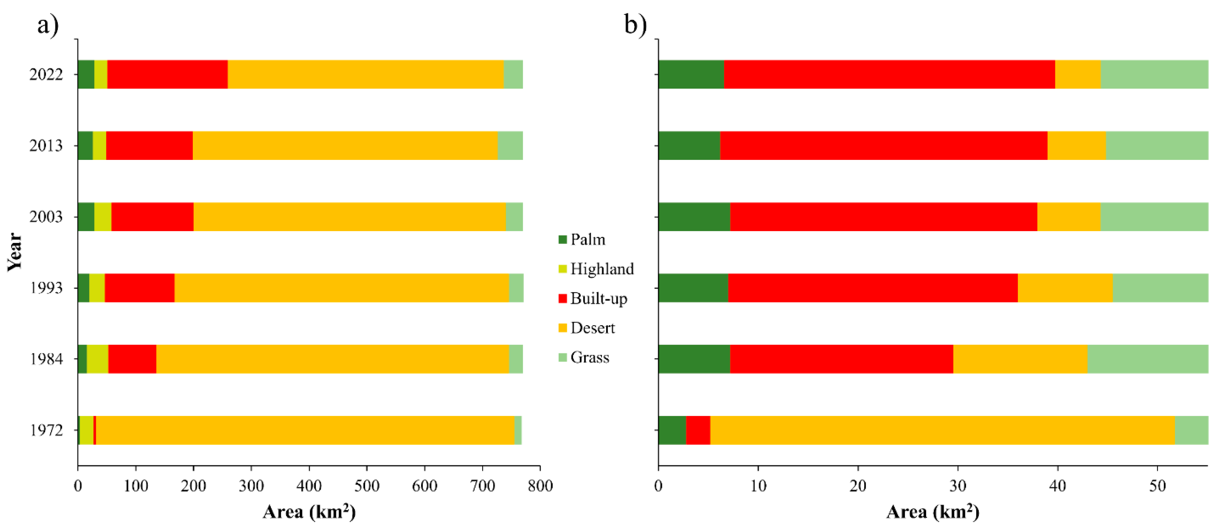
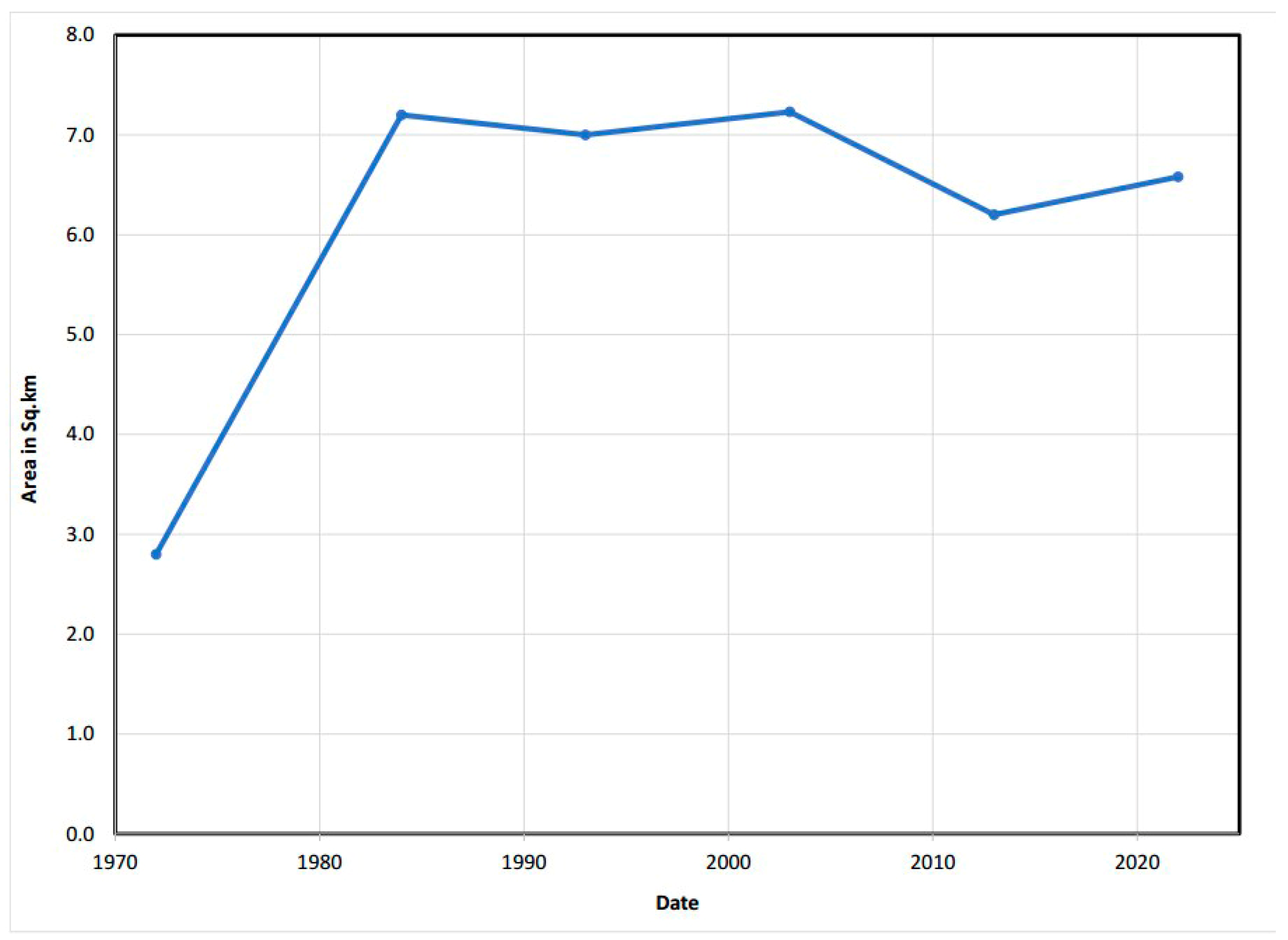
| Class | 1972 | % 1972 | 2022 | % 2022 | % Change (1972–2022) |
|---|---|---|---|---|---|
| Palm | 2.8 | 5.05 | 6.58 | 11.88 | 57.45 |
| Built-up | 2.4 | 4.33 | 33.13 | 59.80 | 92.76 |
| Desert | 46.5 | 83.94 | 4.59 | 8.29 | −914 |
| Grass | 3.7 | 6.68 | 11.1 | 20.04 | 66.67 |
| Total | 55.4 | 55.4 |
Disclaimer/Publisher’s Note: The statements, opinions and data contained in all publications are solely those of the individual author(s) and contributor(s) and not of MDPI and/or the editor(s). MDPI and/or the editor(s) disclaim responsibility for any injury to people or property resulting from any ideas, methods, instructions or products referred to in the content. |
© 2023 by the authors. Licensee MDPI, Basel, Switzerland. This article is an open access article distributed under the terms and conditions of the Creative Commons Attribution (CC BY) license (https://creativecommons.org/licenses/by/4.0/).
Share and Cite
Yagoub, M.M.; AlSumaiti, T.; Tesfaldet, Y.T.; AlArfati, K.; Alraeesi, M.; Alketbi, M.E. Integration of Analytic Hierarchy Process (AHP) and Remote Sensing to Assess Threats to Preservation of the Oases: Case of Al Ain, UAE. Land 2023, 12, 1269. https://doi.org/10.3390/land12071269
Yagoub MM, AlSumaiti T, Tesfaldet YT, AlArfati K, Alraeesi M, Alketbi ME. Integration of Analytic Hierarchy Process (AHP) and Remote Sensing to Assess Threats to Preservation of the Oases: Case of Al Ain, UAE. Land. 2023; 12(7):1269. https://doi.org/10.3390/land12071269
Chicago/Turabian StyleYagoub, M. M., Tareefa AlSumaiti, Yacob T. Tesfaldet, Khaled AlArfati, Maythaa Alraeesi, and Mariam Eid Alketbi. 2023. "Integration of Analytic Hierarchy Process (AHP) and Remote Sensing to Assess Threats to Preservation of the Oases: Case of Al Ain, UAE" Land 12, no. 7: 1269. https://doi.org/10.3390/land12071269
APA StyleYagoub, M. M., AlSumaiti, T., Tesfaldet, Y. T., AlArfati, K., Alraeesi, M., & Alketbi, M. E. (2023). Integration of Analytic Hierarchy Process (AHP) and Remote Sensing to Assess Threats to Preservation of the Oases: Case of Al Ain, UAE. Land, 12(7), 1269. https://doi.org/10.3390/land12071269


