Article

Urban Human Settlement Vulnerability Evolution and Mechanisms: The Case of Anhui Province, China

1
School of Geography, Liaoning Normal University, Dalian 116029, China
2
Key Research Base of Humanities and Social Sciences of the Ministry of Education, Center for Studies of Marine Economy and Sustainable Development, Liaoning Normal University, Dalian 116029, China
*
Author to whom correspondence should be addressed.
Land 2023, 12(5), 994; https://doi.org/10.3390/land12050994
Submission received: 9 April 2023 / Revised: 29 April 2023 / Accepted: 29 April 2023 / Published: 30 April 2023
(This article belongs to the Section Urban Contexts and Urban-Rural Interactions)

Abstract

:
In this paper, taking the jurisdiction of Anhui Province as the research area, a vulnerability assessment index system of human settlements was constructed from “exposure–sensitivity–coping ability”. Based on the GIS spatial analysis method, the spatial and temporal evolution characteristics of human settlements in Anhui Province were analyzed. The influences of human factors and natural factors on the spatial differentiation of human settlement vulnerability were explored by using geographic detectors, and the driving mechanism of the evolution of human settlement vulnerability was analyzed. An analysis of the results showed the following: ① With a change in the time scale, the human settlement vulnerability index showed a trend of decreasing year by year, the exposure and sensitivity show a downward trend year by year in the three major subsystems, and the coping ability shows an upward trend year by year. ② The evolution of the vulnerability subsystems of exposure, sensitivity, and coping ability in human settlement environments showed the directions of “medium–high–low (M-H-L)” in the early stage, “low–high–medium (L-H-M)” in the middle stage, and “low–medium–high (L-M-H)” in the later stage. ③ The causes of high vulnerability were as follows: The leading factors in the early stage were natural factors, the leading factors in the middle period were natural and human factors, and the leading factors in the later stage were human factors. ④ One-factor and two-factor interactive detection using a geodetector showed that urbanization, industrialization, land use control, and per capita income levels have become key and “short-board” factors that control the vulnerability of human settlements.

1. Introduction

The environment of urban human settlements is an important indicator to test whether the economic and social environment of a region or country is healthy. The acceleration of urbanization in China has promoted the improvement of urban appearance, but it has also induced urban problems, resulting in the fragility of human settlements [1,2]. In the face of changes in human settlements in cities, human settlement environment research also needs to keep pace with the times, and vulnerability research has gradually become an important part of urban human settlement environment research [3,4]. Geography has gradually occupied an important position in the study of the vulnerability of urban human settlements by virtue of its advantages of comprehensive systematization, regional differences, dynamic development, and spatial technology [5]. At present, the research on urban human settlement environments mainly focuses on the following aspects: First, the quality of an urban human settlement environment is evaluated based on indicator systems, such as the “hard environment—soft environment” of human settlements [6], satisfaction and suitability evaluations [7,8], and spatial difference analyses of its comprehensive mass and its influencing factors [9]. Second, high-level research results have emerged on the evolution process and mechanisms of urban human settlements from different stages of the evolutionary path and internal and external driving perspectives [10,11]. The third is urban human settlements and social economy [12] and urbanization [13]. Research on the coupling and coordination relationship between tourism and other industries is increasing [14]. Current research focuses on the evaluation of urban human settlement quality in a single year or during a specific time period [15,16]. Research must be conducted on sustainability [17]. There is a lack of discussion on the evolution of urban human settlement vulnerability and its mechanisms in a long-term time series.
Urban human settlement vulnerability evolved from the concept of vulnerability. As a carrier of vulnerability, it can withstand pressure from the outside world, adjust and cope with the drawbacks caused by the dual disturbance of natural factors and human factors, and adapt to its own development law [18]. Anhui Province in China is an important link in the Yangtze River Delta urban agglomeration. Compared with Jiangsu, Zhejiang, and Shanghai, its economic development and urban construction capabilities are relatively weak, and its extensive development model is easily disturbed by both natural ecology and human activities. For example, resource-based cities such as Huaibei and Ma’anshan in Anhui Province are susceptible to environmental damage to a certain extent during the process of resource exploitation [19].
Remote sensing and GIS are powerful tools for understanding, modeling, and mapping the complex systems of urban human settlements and their vulnerability [20,21]. With remote sensing, high-resolution satellite imagery can be used to identify and monitor land use and land cover changes, vegetation health, and surface temperature, providing valuable information for assessing urban environmental conditions and their changes over time. GIS can be used to integrate various datasets and perform spatial analysis, allowing for a better understanding of the relationships between different factors that contribute to urban environmental vulnerability, such as population density, urban infrastructure, and climate [22]. By combining remote sensing and GIS, it is possible to develop models to simulate and predict future changes in urban environmental conditions, and to map areas of high vulnerability and prioritize intervention strategies. Remote sensing data still have certain limitations. Factors such as clouds and atmospheric interference need to be considered during data acquisition, which could affect the quality of the data. The spatial and temporal resolution of remote sensing data are limited by technology and cost, making it difficult to meet high-precision requirements. Additionally, remote sensing data can only provide information on the Earth’s surface and cannot acquire information on multiple environmental parameters such as groundwater, soil, and atmosphere [23,24]. The selected research area in this paper is Anhui Province, where there are no territorial disputes or conflicts.
Considering the complexity of multiple factor perturbations in the study area, this paper mainly constructed a vulnerability index system for urban human settlements based on the dimension of “exposure–sensitivity–coping ability”. Based on the three-subsystem indicator constructed in this research, and drawing on existing indicator systems while taking into account the intercorrelation among indicators, the original indicators were first normalized using the min–max method. The CRITIC method was then used to determine the weights of the indicators, and each indicator was assigned its respective weight. The spatial and temporal characteristics of the vulnerability of urban human settlement in Anhui Province were analyzed [25,26]. A correlation analysis and a geodetector were used to explore the natural and human factors that influence the vulnerability of urban human settlements in the region [27,28], dissect the underlying driving mechanisms, make reasonable suggestions for improving the urban living environments in the region, and provide strong support for the early realization of the integrated development of the Yangtze River Delta.

2. Overview of the Study Area and Data Sources

2.1. Overview of the Study Area

Anhui Province is located in the Yangtze River Delta region of East China. The climate is mainly a warm, temperate, semi-humid, monsoon climate and a subtropical, humid, monsoon climate, with four distinct seasons and rains concentrated in summer. The topography is dominated by plains, mountains, and hills. The territory is rich in water resources. There are 580 lakes in total. The Yangtze, Huai, and Xin’an Rivers run through the entire northern and southern regions. Anhui Province is also a weak link in the urbanization process and socio-economic development in the Yangtze River Delta. It has jurisdiction over 16 prefecture-level cities, 9 county-level cities, and 50 counties. The total area is 140,100 km2. Due to the complexity of its own natural conditions and the diversity of human settlements, as well as the relatively weak ability to cope with external risks and challenges in the Yangtze River Delta region, Anhui Province was selected as the study area in this paper. This paper takes the 16 prefecture-level cities in Anhui Province as a research object. The regional scale of Anhui Province is also used as a research object. It has a certain typical, guiding significance for discussing the improvement of urban living environments in underdeveloped areas in urban agglomerations (Figure 1).

2.2. Data Sources

The data in this paper are derived from the statistical yearbook data from 2005 to 2020; the yearbooks used were “Anhui Statistical Yearbook”, “China Urban Statistical Yearbook”, “China Urban Construction Statistical Yearbook”, “China Regional Economic Yearbook”, “China Environment Statistics Yearbook”, etc. The land use data is derived from the annual China Land Cover Dataset (CLCD) spanning from 1990 to 2021, which was created by Professors Jie Yang and Xin Huang from Wuhan University using 335,709 Landsat images on Google Earth Engine. The spatial resolution of the dataset is 30 m. The data are classified according to the national standard of “Classification of Land Use Status” (GB/T21010-2017). This paper conducts a spatio-temporal analysis of the urban human settlement vulnerability in Anhui Province using ArcGIS 10.2 software. Python 3.9.1 software is used to clean and organize the data of urban human settlement vulnerability in Anhui Province and calculate the corresponding weights. R language is used to draw a relationship diagram between the three indicators of exposure, sensitivity, and coping ability of urban human settlement, while Fragstats is used to calculate the landscape pattern index of land use.

2.3. Data Retrieval and Input

The data used in this paper mainly comes from the official website of Anhui Provincial Bureau of Statistics (http://tjj.ah.gov.cn/(accessed on 5 April 2021)) for Anhui Statistical Yearbook, and from the official website of the National Bureau of Statistics of China (http://www.stats.gov.cn/(accessed on 5 April 2021)) for China Urban Statistical Yearbook, China Regional Economic Yearbook, and China Environmental Statistical Yearbook. The data for China Urban Construction Statistical Yearbook mainly comes from the official website of the Ministry of Housing and Urban-Rural Development of the People’s Republic of China (https://www.mohurd.gov.cn/(accessed on 13 May 2021)). For data not included in earlier official websites, the China National Knowledge Infrastructure (CNKI) yearbook retrieval tool, which is the largest literature data retrieval platform in China, was used for retrieval (https://kns.cnki.net/kns/advsearch?dbcode=CYFD(accessed on 3 June 2021)). The land use data used in this research is mainly from the CLCD dataset of the Wuhan University team (https://zenodo.org/record/5816591#.ZEUtMM5BzGI (accessed on 8 June 2021)). All data used in this paper are published by official websites and databases in China, and the data authenticity and reliability are high. The data time range covers from 2005 to 2020, and the spatial resolution of land use data is 30 m, with high accuracy and precision.

3. Research Methods

3.1. Construction of Human Settlement Vulnerability Assessment Index System

3.1.1. CRITIC Indicator Weight Calculation

Due to the different dimensions of the evaluation indicators, in terms of both the grading values of the indicators and the units of measurement, they are not directly comparable. Different properties are used, but indicators at different scales are equally comparable. The values of all data are distributed between 0 and 1. Dispersion standardization was carried out on the raw data.
X = x x min x max x min   ( Positive indicators )
X = x max x x max x min   ( Negative indicators )
Here, X is the value after dispersion standardization, x is the original value, xmin is the minimum value of the original value, and xmax is the maximum value of the original value.
The CRITIC method determines the weight value by determining the objective weight of the index and by evaluating the contrast intensity and conflict between the indicators [29]. Contrast intensity is expressed in the form of standard deviation. That is, the magnitude of the standard deviation indicates the degree of variation in each data sample within the same indicator. The larger the standard deviation, the greater the difference in the sample values over time. The conflict between the indicators is based on the correlation between them: a strong positive correlation between two indicators indicates a low conflict, whereas a negative correlation indicates a strong conflict.
C j = σ j j = 1 n ( 1 r i j )
The jth indicator that conflicts with the other indicators is (1 − rij), rij is the Pearson’s correlation coefficient between indicators i and j, and σj is the standard deviation of the indicator. A larger Cj indicates that the jth evaluation indicator contains more information and that the relative importance of the indicator is greater.
The objective weight of the jth indicator, Wj, should be
W j = C j j = 1 n C j
( j = 1 , 2 , 3 , , n )

3.1.2. Exposure

Taking prefecture-level cities as the bearers of risk disturbances, risk disturbance factors should be considered as a collection of direct or indirect threats and damage factors to the carrier, which directly lead to the emergence of various “urban problems” [30]. The main ones are as follows: ① Low per capita daily water consumption and low per capita water consumption. This indicates that the allocation of local water resources is unreasonable, domestic water is not guaranteed, and the vulnerability of human settlement is high. ② The non-point source pollution index of farmland. This quantifies the degree of cultivated land source pollution (see Formula (5), where Aij is the amount of fertilizer applied to cultivated land, and Bb is the total area of arable land). ③ The number of traffic accidents that have occurred. According to the gray correlation theory, the geometry of the curve formation composed of each reference series is proposed to determine whether they are closely related via geometric similarity. Using traffic accident report data combined with the gray correlation model analysis, the correlation degree between accident probability and intersection form and road surface conditions is greater than 0.9. The frequency of traffic accidents can be seen to show the degree of matching between the transportation infrastructure and the living environments in a region. A frequent occurrence of traffic accidents indicates that the matching degree of transportation facilities in the area is low and that the living environment is not optimistic. ④ The average noise. The continuous advancement of urbanization will inevitably generate urban noise, and the harm caused by noise is not only auditory system damage but also non-auditory system damage, affecting human settlements. ⑤ The incidence of population fires, modern urban underground space and facilities, and chemical and energy areas. Fire hazards are greater, and the negative effect on human settlements is significant. ⑥ The discharge of industrial wastewater, waste gas, solid waste, and other emissions. This will pollute the air, domestic production water, and soil resources, and the impact on human settlements is irreversible.
F P I = ( A i j + A t j ) / B b

3.1.3. Sensitivity

The sensitivity of human settlements to disasters or disturbances is measured using sensitivity indicators [31]. The main indicators are as follows: ① The annual average temperature and humidity index. This is usually used to describe whether the human production environment is in a state of heat stress and, if so, the degree. It is the most classic indicator used to evaluate the state of human heat stress and physical comfort (see Equation (6), where T is the local temperature data, and RH is the humidity data). Previous studies have shown that THI = 55~60 is when the body feels cool and comfortable and that THI = 60~65 is when the body feels cool and very comfortable; this indicator is a moderate index. The temperature and humidity index of the 16 prefecture-level cities in Anhui is within this range. In order to facilitate calculation, the value of THI is between about 55 and 65. The larger the value, the more comfortable the body feels. ② The number of days with air quality of or better than level 2. The quality of air reflects the degree of air pollution; the worse the air quality, the higher the respiratory morbidity and the more sensitive the living environment. ③ The green coverage of the built-up area. The higher the vegetation coverage, the stronger the carbon sequestration and oxygen release capacity and the lower the sensitivity of the living environment. ④ The degree of land use development. The land use data are processed using a GIS fishing net raster (see Formula (7), where Lj represents the land use development degree index of a certain area, Ai is the land use grading number of level i, CCi is the land use area of level i, Hj is the total land area of the study area, and n is the number of land use degree grading (1 for woodland, shrubs, and grasslands; 2 for water bodies and wetlands; 3 for farmland and bare land; and 4 for construction land)). The higher the degree of land use development, the greater the sensitivity of the human settlement environment. ⑤ The landscape sensitivity index (see Equation (8)). The landscape fragmentation index (Cj), the landscape separation index (Sj), and the landscape dominance index (Dj) are selected, and the weights of the three are superimposed to obtain the landscape interference index (Ej). According to previous research results, the importance of the three is presented in the order of the landscape fragmentation index > the landscape separation index > the landscape dominance index, and they can be assigned weight values of 0.5, 0.3, and 0.2 (0.5 + 0.3 + 0.2 = 1), respectively. Nj is the number of plaques, Aj is the number of plaques of type j, A is the total area of plaques, and SHEI is the Shannon diversity index. The more obvious the landscape disturbance, the higher the sensitivity of the landscape and the more sensitive the human settlements. ⑥ Urban population density, highway density (according to highway mileage/per 10,000 people), and plaque density. According to relevant research, it is known that the more sensitive the human settlements with a dense population, the higher the highway density and the larger the patch fragmentation.
T H I = ( 1.8 × T + 32 ) ( 0.55 0.55 × R H × 0.01 ) × ( 1.8 × T 26 )
L j = i = 1 n A i × C C i H j
C j = N j / A j S j = 1 2 N j A A j / A D j = 1 S H E I
E j = 0.5 × C j + 0.3 × S j + 0.2 × D j

3.1.4. Coping Ability

The coping capacity indicates a series of coping measures taken to reduce the damage to human settlement environments and to reduce the negative impact of human settlement environments affected by exposure and sensitivity. The selection of coping capacity indicators is mainly based on the actual situation in Anhui Province [32]. ① The negative impact of natural factors is reduced through sewage treatment and afforestation areas, as well as park green space per capita. ② The negative impact of economic development factors is reduced through GDP per capita. ③ The negative impact of urban areas within the jurisdiction of the city is reduced through the construction of urban municipal public facilities, fixed-asset investment, urban community service facilities, and the daily production capacity of urban water supply. ④ The negative impact of the city is reduced through the popularization of urban tap water and sanitary toilets (Table 1).

3.2. Human Settlement Vulnerability Index

Using the CRITIC weight method, the index weight value of each specific index is obtained, and the weight values of the three subsystems of exposure, sensitivity, and coping ability are obtained. The weight value of each subsystem is multiplied by the dispersion normalization value of the original data to obtain the vulnerability value of each index. The vulnerability value for each indicator is aggregated for each city’s human settlement vulnerability index. See (9) for specific formulas, among which αeps, βssp, and ψcpa are the CRITIC weights of the three subsystems of exposure, sensitivity, and coping ability, respectively; Xeps, Xssp, and Xcpa are the standardized values of dispersion of each specific index, respectively; and n is the number of specific indicators.
V = m = 1 n α e p s X e p s + m = 1 n β s s p X s s p m = 1 n φ c p a X c p a

3.3. Pearson’s Correlation Analysis Method

Pearson’s correlation is used to measure the linear correlation between two variables X and Y, and the values are within (0,1), which provides a more scientific characterization of the correlation between the three subsystems and the vulnerability of human settlements [33]. This paper selects the correlations between exposure, sensitivity, coping ability, and the human settlement vulnerability index in 2005, 2010, 2015, and 2020 in the province; analyzes their linear correlations; and implicitly makes Gaussian assumptions. Usually, 0.8–1.0 is a very strong correlation, 0.6–0.8 is a strong correlation, 0.4–0.6 is a moderate correlation, 0.2–0.4 is a weak correlation, and 0.0–0.2 is a very weak correlation or no correlation. Ρ is the sample correlation coefficient; Xi and Yi are the i-point observations corresponding to X and Y, respectively; and X ¯ is the sample mean of X.
ρ = i = 1 n ( X i X ¯ ) ( Y i Y ¯ ) i = 1 n ( X i X ¯ ) 2 i = 1 n ( Y i Y ¯ ) 2

3.4. Geodetector

Geodetectors are used to test the spatial heterogeneity of univariates and the coupling of bivariate spatial distributions in order to detect causal relationships between two variables. They are mainly divided into risk detectors, factor detectors, ecological detectors, and interactive detectors. The core idea of geodetectors is based on the assumption that, if an independent variable has a significant effect on a dependent variable, then the spatial distribution of the independent and dependent variables should be similar. In this paper, factor detection and interaction detection are mainly used [34,35,36].
Differentiation and factor detection: In this paper, the GIS-Jenks natural break point grading method is used to classify the original values of the 26 variables and to divide them into 5 grade categories in order to detect the spatial heterogeneity of human settlement vulnerability and the extent to which index factor X explains the spatial differentiation of attribute Y (human settlement vulnerability index). The q value is used to measure the degree of influence of each specific index on the human settlement vulnerability value. The larger the q value, the stronger the explanatory power of the independent variable X for the dependent variable Y.
It is determined whether the use of the explanatory power of the joint effect of factors enhances the assessment of the vulnerability of human settlements. If a relationship between two-factor enhancement and nonlinear enhancement is presented, this indicates that the joint effect of the vulnerability impact factors of human settlements increases the strength of the interpretation of the vulnerability levels of urban human settlements.
q = 1 i = 1 j M i φ i 2 M φ 2 = 1 S S W S S T
Here, i = 1, …; j is the hierarchical number of factor X; Mi and M are the number of elements of layer i and the whole region, respectively; ψi2 and ψ are the variance of the Y values of layer i and the whole region, respectively; and SSW and SST are the sum of the intralayer variance and the total variance of the whole region, respectively.

4. Evolution Characteristics of Human Settlement Vulnerability in Anhui Province

4.1. Spatial Structure Evolution of the Human Settlement Vulnerability Subsystems

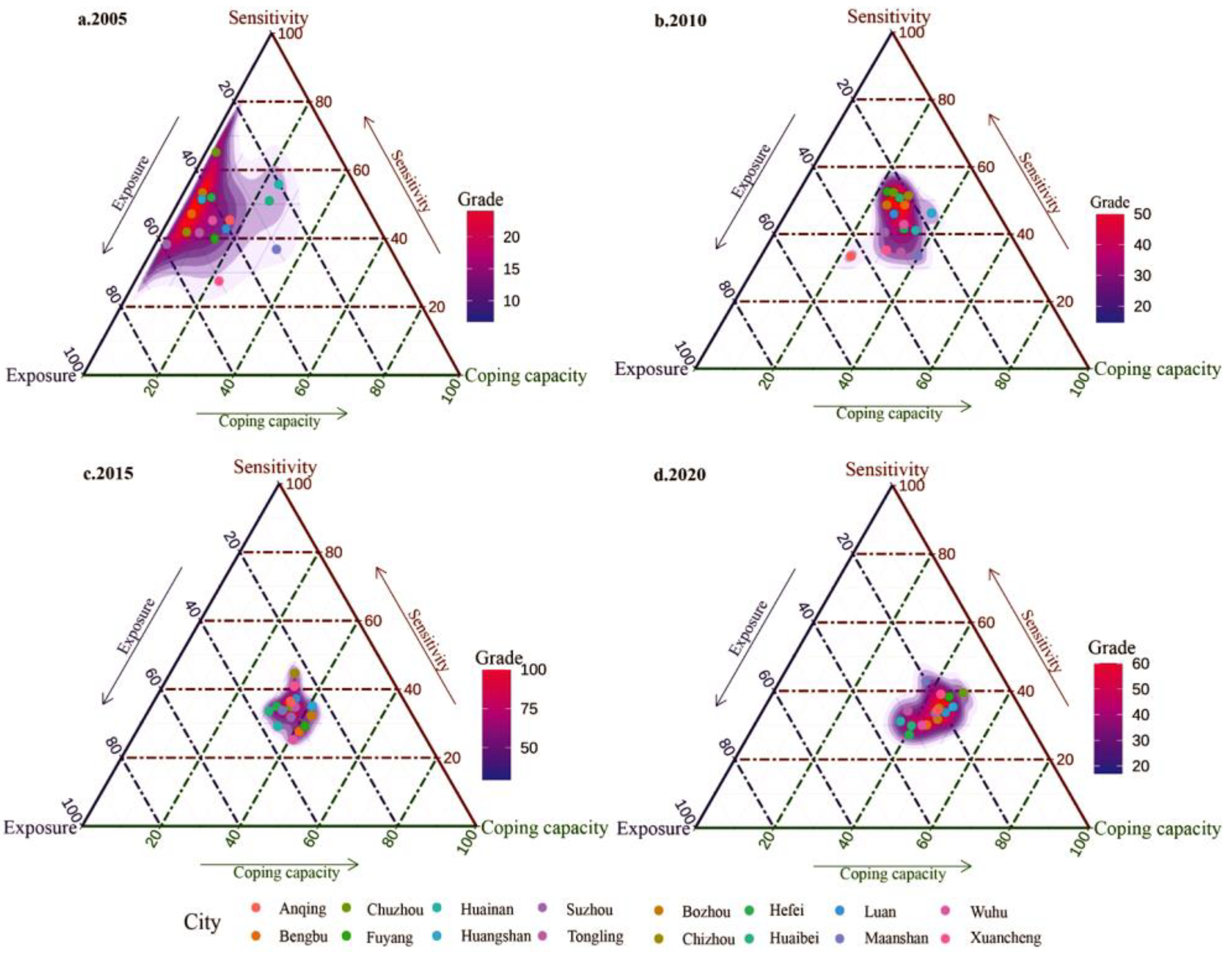
The exposure index, the sensitivity index, and the coping capacity index of the 16 prefecture-level cities in Anhui Province in 2005, 2010, 2015, and 2020 were calculated using Formula (9), and a three-phase chart was used to determine the evolution process of their spatial structures.

4.1.1. The Evolution of the Human Settlement Vulnerability Subsystems Showed the Direction of “Medium–High–Low (M-H-L)” in the Early Stage

In 2005, the early stage of the vulnerability of the human settlement environments in Anhui Province mainly shows a trend of a medium exposure, a high sensitivity, and a low coping capacity, and the overall aggregation degree of the three major subsystems of the prefecture-level cities is relatively scattered. There is a trend of low-level aggregation, and the aggregation state shows an “N”-shaped structure. Except for Ma’anshan, Wuhu, Hefei, and other cities with relatively strong coping capacity, the coping capacity of the other cities was in an extremely weak position. There is no doubt that the living environment at this stage was dominated by exposure and sensitivity, and the overall situation was not optimistic.

4.1.2. The Evolution of the Human Settlement Vulnerability Subsystems Showed the Direction of “Low–High–Medium (L-H-M)” in the Middle Stage

The years 2010 and 2015 are the middle stages of the subsystem research on the vulnerability of human settlements in Anhui Province, which presents a low exposure, a high sensitivity, and a medium coping capacity. Each prefecture-level city basically shows a kind of glued, clump-like aggregation distribution; this is due to the slogan of the strong provincial capital, accelerating Hefei to become a modern big city, with the gradual implementation of urban agglomeration construction and other development ideas, such as “Wuma Tongyi” becoming the axis of the Anhui River Urban Belt and “two Huai and one mussel”. The development and transformation of coal-resource-based cities, such as Huainan and Huaibei, have accelerated the speed of urbanization, and the radiation driving effect of the Hefei metropolitan area has reduced the exposure index. Due to the acceleration of urbanization in Anhui Province and the continuous improvement of the level of urban infrastructure, the “urban disease” has become increasingly prominent, and the sensitivity index is increased at this stage. With the continuous improvement of the level of economic development, the ability to cope with vulnerability disturbances is also constantly advancing, increasing from a low-level coping capacity to a medium-level coping capacity.

4.1.3. The Later Evolution of the Human Settlement Vulnerability Subsystems Showed the Direction of “Low–Medium–High (L-M-H)”

The year 2020 is the later stage of the research on the vulnerability subsystems of human settlement environments in Anhui Province, which presents a low exposure, a medium sensitivity, and a high coping capacity. The degree of aggregation in each prefecture-level city still shows a glued, clump-like aggregation distribution. The aggregation state presents a “one”-shaped structure, and the overall direction tends to be a high coping capacity that is notably tilted. At this stage, the comprehensive functions of towns have been improved; underground comprehensive pipe corridors and “sponge cities” have been constructed; the comprehensive management of Chaohu Basin, Huaihe River Basin, and Yangtze River Basin (Anhui River Section) within the provincial jurisdiction has achieved remarkable results; and the exposure index has been running at a low level. Compared with the medium stage, the sensitivity is reduced to the medium level; the treatment of “urban diseases” has achieved remarkable results; the liberalization of urban municipal facility management and landscaping maintenance has accelerated; the informatization of community service management, the construction of digital urban management platforms, the management of community grids, and other advanced comprehensive urban governance initiatives have alleviated the continued spread of “urban diseases”; and the sensitivity of the vulnerability subsystem of human settlements is loosened. As the response measures of urban human settlements are more scientific and rational, the response capacity has changed from low operation in the initial stage and medium operation in the middle stage to high operation in the current stage.

4.1.4. Overall Trend of the Evolution of the Human Settlement Vulnerability Subsystems

From an overall view of the three-phase diagram (Figure 2), the development trend of the exposure index decreasing from a high index to a low index is obvious. It can be seen that the exposure component factor is a collection of direct disaster factors, and this factor easily changes greatly when external factors change. Sensitivity reflects the degree of sensitivity to disasters and disturbances, is less susceptible to external factors, and has less variation in the initial and medium stages. The change in the coping capacity is the most direct change in human settlement vulnerability. The overall trend tends to be a “high–medium–low” development model, which is in line with the overall trend of the declining human settlement vulnerability index in Anhui Province (Figure 2).

4.2. Characteristics of the Spatio-temporal Evolution of Human Settlement Vulnerability

4.2.1. Timescale Changes in Human Settlement Vulnerability in Anhui Province in Main Years

In order to more clearly see the overall trend of the human settlement vulnerability index in Anhui Province, a comprehensive human settlement vulnerability index for the years 2005–2020 is used.
As can be seen in Figure 3, the annual increase and the composite index of human settlement vulnerability showed a downward trend year by year. It is obvious that, compared with the 2005 human settlement vulnerability index, the high value fluctuation trend of the provincial comprehensive index in the early stage of 2005–2010 and the human settlement vulnerability index in 2010 and 2015 in the medium stage showed a fluctuating downward trend and a weakened vulnerability. In the later stage of 2020, the overall human settlement vulnerability index of the province showed a downward trend, and compared with previous years, the human settlement vulnerability index was relatively low, and the vulnerability of all localities and cities was in a state of low operation. This shows that the vulnerability index of human settlements in Anhui Province is gradually declining, the degree of human settlements affected by the outside world is gradually decreasing, human settlement environments are being better managed, and the quality of human settlement environments is steadily improving.

4.2.2. Spatial Scale Changes in Human Settlement Vulnerability in Anhui Province in Main Years

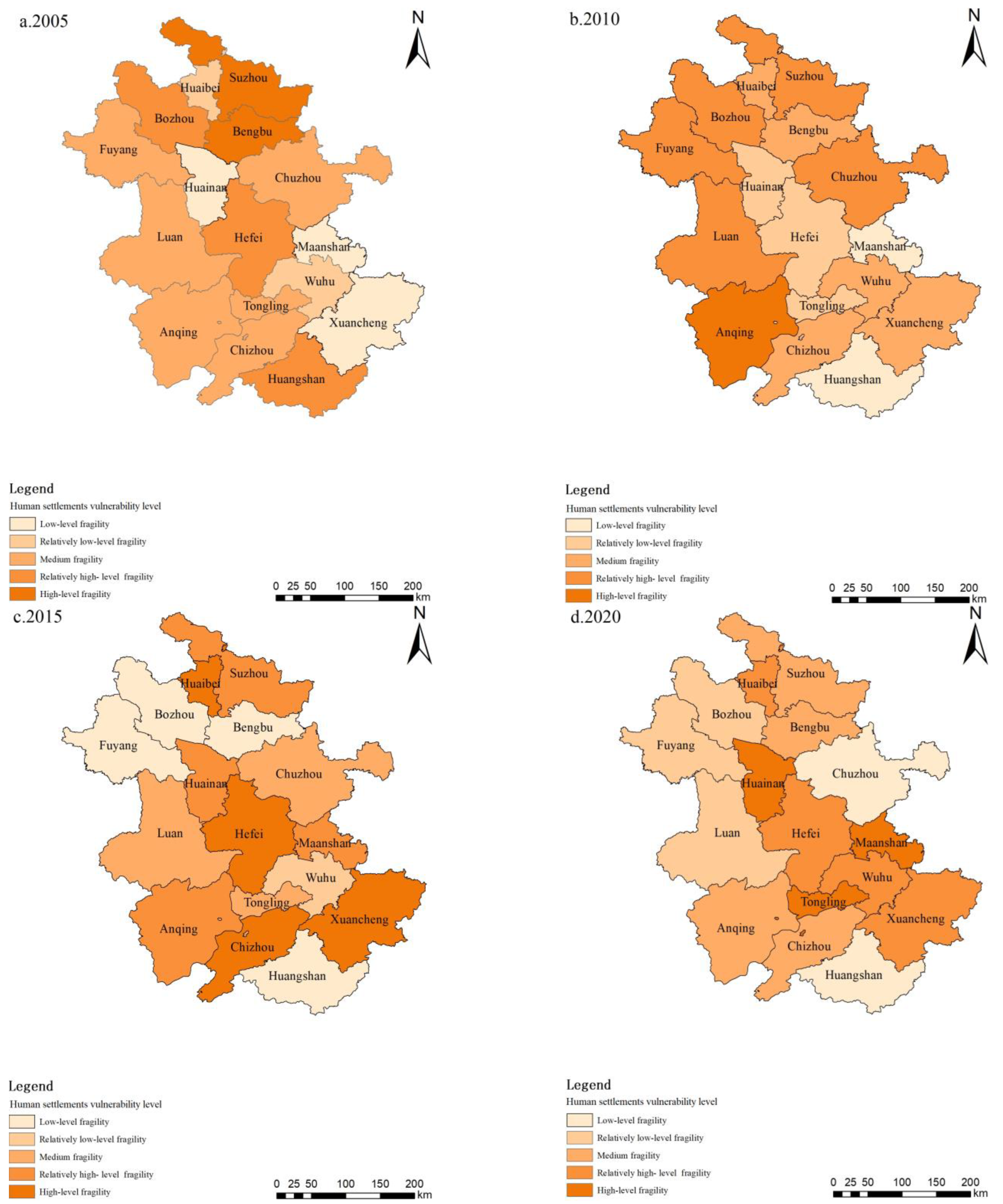
In order to better measure the differences in the different spatial units in the same time scale, this paper takes the 16 prefecture-level cities as the basic spatial units and makes a horizontal comparison of the human settlement vulnerability index of the various prefecture-level cities to observe the spatial differences between them. Using the GIS-Jenks natural fracture point method, the cities are divided into five levels of fragility, namely low-level fragility, relatively low-level fragility, medium-level fragility, relatively high-level fragility, and high-level fragility, and the classification criteria of each stage are based on the standards of the year (Figure 4).
In the early stage, in 2005, Suzhou City and Bengbu City were highly vulnerable compared with the other spatial units, mainly because the early natural environment in the region was seriously damaged, and the economic and social development was insufficient to support the improvement of the human settlement environments in the region. Bozhou, Hefei, and Huangshan were relatively fragile, and Hefei’s rapid development model of “Spread the flatbread” caused great damage to human settlement environments. The main economic sources of Bozhou and Huangshan were single, meaning that they had single economic structures, and a single economic structure makes it difficult to reduce the disturbance of the external damage factors of human settlement environments. The remaining cities had low- and medium-level fragility and a relatively good resistance compared to the other spatial units.
In the intermediate (early) stage, in 2010, compared with the other 16 spatial units, Anqing had high-level vulnerability, and Lu’an, Fuyang, Bozhou, Suzhou, and Chuzhou were relatively fragile. Anqing had medium-level vulnerability in the early stage, and it upgraded to high-level vulnerability at this stage. This is mainly because the region was affected by frequent natural disasters and meteorological disasters in the southwest mountain range, and its ability to reduce natural disaster risks was poor. In Lu’an, Fuyang, Bozhou, Suzhou, and Chuzhou in Anhui Province, most of the socio-economic development was in a relatively low position, human settlement environments were highly sensitive and vulnerable to external influences, and the coping ability was relatively weak compared with the other basic spatial units. In the medium (post) stage, in 2015, Hefei, Chizhou, Xuancheng, and Huaibei were highly vulnerable to human settlements compared with the other spatial units. After 2010, the vulnerability of Hefei human settlements upgraded to a high level, the administrative division was adjusted, the slogan of “strong provincial capital” was proposed, urbanization developed rapidly, urban problems were prominent, and the vulnerability of urban human settlements continued to increase compared with the other spatial units. Chizhou City and Xuancheng City had better natural scenery, but they still had single economic structures, and this makes it difficult to reduce the interference factors that come from different sources. Huaibei City and Huainan City are well-known coal-resource-based cities in Anhui Province, and the transformation and development of resource-based cities were slow and fragile.
In the later stage of 2020, compared with the other 16 basic spatial units, Ma’anshan City, Tongling City, and Huainan City had high-level fragility. Ma’anshan was relatively vulnerable in the middle (post) stage, and it suddenly upgraded to high vulnerability. During this period, Ma’anshan fully joined the Nanjing metropolitan area and was actively integrated into the Yangtze River Delta, and the problem of “urban disease” became more prominent. Tongling was upgraded from medium vulnerability to high vulnerability, mainly because the hinterland of Tongling development in the early stage was small, and there were very few counties under its jurisdiction. Furthermore, after the middle stage, the administrative division was adjusted, and Zongyang County was placed under the jurisdiction of Tongling. Huainan changed from having relatively high-level vulnerability to having high-level vulnerability, and the reason for this is still that transformation and upgrading failed to reduce external risks (Figure 4).
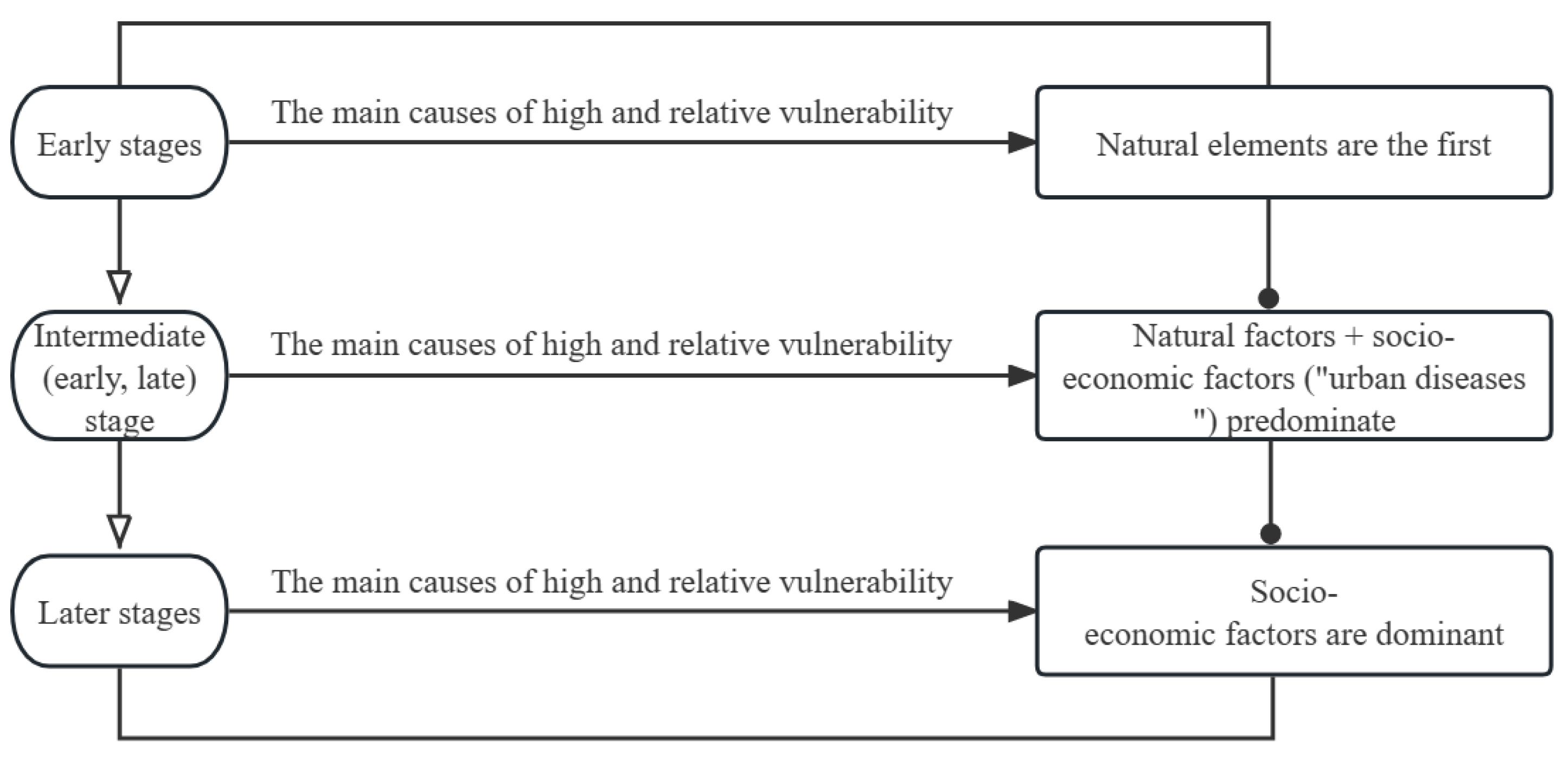
In the early stage, the vulnerability of most of the highly vulnerable cities and relatively highly vulnerable cities in Anhui Province was caused by natural factors. Furthermore, the level of economic development was low, and the ability to reduce natural risk factors was weak. The highly vulnerable and relatively highly vulnerable cities in the medium stage are still areas that have relatively low socio-economic development. Most of the cities that are highly vulnerable and relatively highly vulnerable in the later stage are cities with relatively good social and economic development, such as Ma’anshan, Hefei, and Wuhu, indicating that economic development and the urbanization process are accelerating and that “urban diseases” and “urban problems” have gradually become the key links leading to the vulnerability of urban human settlements (Figure 5).

5. The Driving Mechanism of the Evolution of Human Settlement Environment Vulnerability in Anhui Province

5.1. Correlation Analysis of Human Settlement Vulnerability Subsystem

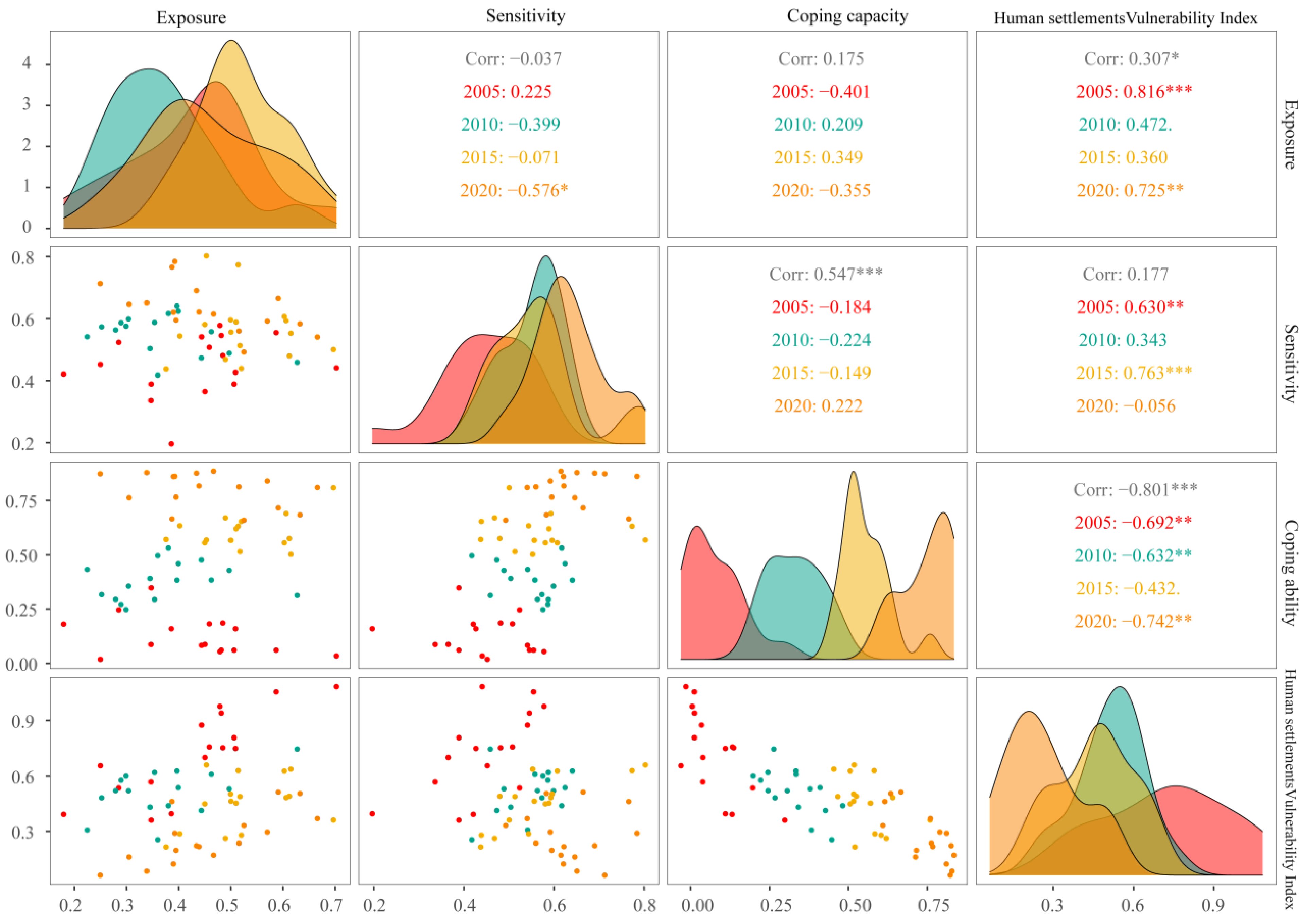
In order to understand the correlation between the three subsystems of exposure, sensitivity, and coping ability in the human settlement vulnerability subsystem and the vulnerability of human settlements, this paper analyzes Pearson’s correlations between these three subsystems and the comprehensive human settlement vulnerability index, as shown in Figure 6.
From the correlation matrix between the vulnerability index of human settlements and exposure, sensitivity, and coping capacity, it can be seen that the exposure system has a significant, strong positive correlation in 2005 and 2020, and there is also a positive correlation with the human settlement vulnerability index in 2010 and 2015. It can be seen that the higher the exposure studied in this paper, the higher the vulnerability of human settlements.
In the sensitivity system, there is a significant positive correlation with the human settlement vulnerability index in 2005 and 2015, a positive correlation in 2010, and a nonsignificant negative correlation in 2020. It can be seen that the higher the sensitivity system studied in this paper, the greater the impact on the vulnerability of human settlements.
In the coping capacity system, there is a significant negative correlation with the human settlement vulnerability subsystem in 2005, 2010, and 2020 and an insignificant negative correlation in 2015. The overall presentation is strong salience and a strong negative correlation. It can be seen that the enhancement of the coping capacity is conducive to the reduction in the vulnerability index of human settlements and the impact of disturbance factors on human settlement vulnerability in this area.

5.2. Analysis of Influencing Factors of Evolution of Human Settlement Vulnerability

The vulnerability of urban human settlements is easily affected by human factors and natural factors, and the degree of influence of the influencing factors varies in different periods. In order to study the degree of influence of each influencing factor on the vulnerability of human settlements, this paper uses geodetectors, and it conducts an interactive detection to observe whether the interaction between specific indicator factors enhances or weakens the degree of interpretation of human settlement vulnerability, as shown in Formula (10).

5.2.1. Differentiation of Human Settlement Vulnerability and Factor Detection

The original values of all specific indicator factors in the four years were classified, and the human settlement vulnerability index was introduced into the geographic detector to detect the degree of interpretation of each single factor X for the human settlement vulnerability index Y, measured using the q value. The larger the q value, the higher the degree of interpretation. The calculation results are shown in Table 2.
It was found that, in terms of exposure, the total amount of industrial wastewater discharged in 2005, the amount of industrial solid waste generated in 2010, the incidence of population fires in 2015, and the amount of solid waste generated in 2020 had the highest values in the system, indicating that they were the strongest explanatory factors affecting the vulnerability of human settlement environments in this system. There was a positive correlation between the exposure and vulnerability of human settlements, and a reduction in exposure was conducive to a reduction in vulnerability. Reductions in industrial wastewater discharge, solid waste discharge, and the incidence of population fires are conducive to reducing exposure and alleviating the vulnerability of human settlements.
From 2005 to 2020, the green coverage rate, land use development degree, and patch density of built-up areas were the highest q factors in the four years. The sensitivity index factor is a vulnerability factor of human settlement environments, and it is easily disturbed; it has positive impact factors and negative impact factors. Furthermore, once such factors change, the effect on sensitivity is more severe. Enhancing the green coverage rate of built-up areas can effectively alleviate the sensitivity of living environments in a timely and effective manner, and it can have an “immediate effect”. Land use development and patch density should be reduced, the urban land use layout should be optimized, and the sensitivity of urban living environments should be alleviated. The sensitivity index had a positive correlation. Adjusting (increasing or decreasing) the factors in the sensitivity system reduces the overall sensitivity level and the vulnerability index of human settlement environments.
Regarding the coping capacity factor, the eligible area of afforestation, the per capita gross domestic product, the number of urban community service facilities, and the qualified area of afforestation had the highest values in 2005, 2010, 2015, and 2020, respectively. Increasing the values of these factors is helpful in reducing the risks, susceptibility, and uncertainty caused by exposure and sensitivity; reducing the human settlement vulnerability index; and improving the ability to respond to various situations.

5.2.2. Interaction Detection of Human Settlement Vulnerability Factors

In order to further understand the degree of explanation of exposure and sensitivity and their co-interactions with coping ability on the sensitivity of human settlements, this paper compares the interactions of the factors in the exposure, sensitivity, and coping ability subsystems with other factors in the subsystems, and it analyzes the explanatory power of the internal interactions of the subsystems. The maximum q values of exposure in the four years are X7, X8, X5, and X8, and the maximum q values of sensitivity in the four years are X11, X14, X11, and X16. The maximum q values of coping capacity in the four years are X18, X17, X23, and X18. The calculation results are shown in Table 3.
In the above table, it can be seen that the Q values of the two-factor interaction in the exposure, sensitivity, and coping capacity indicators are 18, 16, and 27, respectively. The explanatory power reaches more than 80%, and the two-factor interaction has a significant impact on the vulnerability of human settlements.
From the internal perspective of exposure, the q range from 2005 to 2020 was 0.192, 0.288, 0.21, and 0.126, showing a trend of first increasing and then decreasing, and the overall value tended to be flat and stable. The interactions between the total industrial wastewater discharge and mean noise, the industrial solid waste generation and average noise, the population fire incidence and farmland non-point source pollution index, and the industrial solid waste generation and average noise had the largest q values from 2005 to 2020. The maximum values of the q factor in the exposure subsystem in the three years of 2005, 2010, and 2020 were the largest after the interaction with the average noise, which reduced the impact of noise on human settlement environments and helped to weaken the overall impact of exposure on the vulnerability of human settlement environments.
From the perspective of sensitivity, the q range from 2005 to 2020 was 0.223, 0.113, 0.082, and 0.347, showing an unstable state of first decreasing and then increasing. The values were unstable and variable, consistent with the instability characteristic of sensitivity and susceptibility to external influences. The interactions between the green coverage in built-up areas and urban population density, the land use development degree and green coverage in built-up areas, the green coverage and patch density in built-up areas, and the patch density and annual average temperature and humidity index had the largest q values in each year from 2005 to 2020. From the maximum interaction q value of sensitivity in each year, it can be seen that the green coverage of built-up areas and the interaction of patch density with other factors had a significant impact on the sensitivity system, and the highest value had the highest frequency. Increasing green coverage and the green coverage area of built-up areas and reducing the density of patches are conducive to reducing sensitivity and to reducing the comprehensive index of vulnerability.
From the perspective of coping capacity, the Q range from 2005 to 2020 was 0.219, 0.221, 0.355, and 0.266, showing a trend of first increasing and then decreasing, and the overall value fluctuated greatly. The interactions between the afforestation areas and urban sanitation toilet penetration rate, the per capita GDP and urban community service facilities, the per capita GDP and urban community service facilities, and the per capita GDP and afforestation areas had the highest q values from 2005 to 2020. GDP per capita and afforestation areas interact with other factors in the best combination, and the highest values occur most frequently. Increasing the per capita GDP and increasing afforestation areas are conducive to coping with the adverse factors affecting human settlements.

5.3. Analysis of the Evolution Mechanism of Human Settlement Vulnerability

Based on the analysis of the factors influencing the vulnerability of human settlements, the keywords with the greatest impact on exposure are “industry” and “noise”, the keywords with the greatest impact on sensitivity are “greening” and “plaque density”, and the keywords with the greatest impact on coping capacity are “gross domestic product” and “afforestation”. The keywords of these most influential factors are integrated and summarized, and the evolution mechanism of human settlement vulnerability is analyzed.

5.3.1. Impact of Industrialization and Urbanization on the Vulnerability of Human Settlements

As is well-known, industrialization and urbanization development are the endogenous driving forces of urban social and economic development. The acceleration of industrialization and the rapid urbanization process will inevitably affect the abnormal response of the living environment. The unreasonable discharge of industrial wastewater, waste gas, and solid waste at each stage of the fragile development of human settlement environments will lead to the rapid deterioration of urban environments and highlight the health problems of residents. The noise pollution caused by urbanization has brought inconvenience to residents in production and life. The harmless treatment of industrial waste gas, wastewater, and solid waste and the remediation of urban noise are of great significance to reducing exposure and improving the self-recovery of subsystems.

5.3.2. The Impact of Government Land Use Regulation on the Vulnerability of Human Settlements

The government’s regulation of land use is an important driving force in reducing the vulnerability of human settlements and in improving the quality of the environment. The government has increased the green coverage of built-up areas and strengthened shrub greenery to improve air quality. The government’s rational land use planning reduces the degree of fragmentation of the landscape and reduces the probability of the irreversible impact of ecological environments on urban living environments. The negative impact of urban land expansion needs to be turned into a positive impact, and the development of urban land needs to be guided in a healthy and sustainable direction.

5.3.3. Impact of Raising per Capita Income Levels on Human Settlement Vulnerability

According to Maslow’s hierarchy of needs, human needs range from the lowest level of physiological needs to self-realization, in which the transformation process and an increase in income level can be understood as catalysts. Income level promotes an increase in consumption level, as well as promoting the transformation of material consumption into spiritual consumption and the pursuit of a higher-level urban living environment. According to the data from the study period, higher levels of per capita income can increase the coping capacity, thereby reducing the vulnerability of human settlements. The income gap between urban and rural areas should be reduced, the ability of rural areas to reduce human settlements risks should be improved, and the vulnerability of human settlements should be reduced as a whole.

6. Discussion

The vulnerability of urban human settlements is shaped by a combination of factors [37]. The influencing factors vary over time. A city’s self-improvement and repair capacities also gradually improve. The advantages and disadvantages of urban social and economic development will continue to be highlighted, and with the continuous improvement of living standards, the requirements of living environments will continue to be updated and improved [38,39,40]. Due to the limitations of data acquisition, the indicators are not further divided according to the five traditional system indicators of human settlements (nature, residence, human beings, support, and society) within the three major systems of exposure, sensitivity, and coping ability, and, in the future, the internal indicators of the three subsystems can be further distinguished according to the traditional five system indicators of human settlements, which will make the study more comprehensive [41,42,43].
As a province in the Yangtze River Delta region, Anhui Province faces significant challenges in maintaining a sustainable and resilient human settlement. In order to address these challenges, policy recommendations could include:
① Promoting sustainable urbanization: Encouraging the development of compact and well-connected cities, which can reduce the environmental impacts of urban sprawl and promote resource efficiency. This could be achieved through policies such as compact city planning, mixed land use zoning, and sustainable transport systems.
② Strengthening ecological protection: Protecting and restoring natural ecosystems is critical for reducing the vulnerability of Anhui’s urban human settlement. This could include measures such as establishing protected areas, improving land use planning and management, and promoting sustainable agricultural practices.
③ Enhancing disaster risk management: Anhui Province is prone to a range of natural hazards, including floods, landslides, and droughts. To reduce the risk of disaster and increase resilience, it is recommended to invest in early warning systems, disaster response planning, and post-disaster recovery and reconstruction.
④ Promoting public participation: Engaging local communities in the decision-making process can increase the effectiveness and sustainability of policies aimed at improving the human settlement. Encouraging public participation through measures such as community-based planning and participatory budgeting can help to build public support and ensure that policies reflect the needs and priorities of local residents.
The study of urban human settlement vulnerability in Anhui Province has some limitations and prospects in terms of the methods used. First, the selection of indicators and the establishment of evaluation criteria need to be further improved to better reflect the characteristics of the region’s human settlement environment. Second, the spatial and temporal resolution of the data used in the study need to be further improved to enhance the accuracy and timeliness of the analysis. In the future, the use of machine learning algorithms and big data technology can further improve the accuracy of the evaluation. Additionally, interdisciplinary collaboration with experts in ecology, urban planning, and public health can also provide a more comprehensive perspective for the research.
Remote sensing technology can play an important role in the study of urban human settlement environment vulnerability. By acquiring high-resolution remote sensing images, the spatial and temporal changes in the urban environment can be monitored and analyzed, providing valuable data for vulnerability assessment. In addition, remote sensing can also be used to assess environmental factors, such as air and water quality, which are important indicators of human settlement environment vulnerability. The combination of remote sensing and other methods can provide a more comprehensive and accurate evaluation of urban human settlement environment vulnerability, which can help guide policy making and improve the quality of life for residents.

7. Conclusions

This paper explores the vulnerability of human settlements in Anhui Province from the perspective of “exposure–sensitivity–coping ability”, analyzes the evolution law and characteristics of human settlement vulnerability in Anhui Province, and explores the single influencing factors and interactive influencing factors that constitute the vulnerability index of human settlement environments by using geographic detectors. By summarizing the evolution mechanism through the influencing factors, the main conclusions are as follows:
On the whole, the vulnerability of human settlements shows an overall downward trend. There is a transition from high vulnerability in 2005 to low vulnerability in 2020. From the perspective of the three major subsystems, exposure shows a trend of decreasing year by year, the sensitivity shows a trend of decreasing year by year, and the coping capacity shows a trend of increasing year by year.
From the perspective of the internal causes of high vulnerability and relatively high vulnerability in various cities, there are three mainstream directions: mainly natural factors in the early stage of human settlement vulnerability, natural and human cross-impacts in the middle stage of human settlement vulnerability, and human factors in the later stage of human settlement vulnerability.
From the correlation analysis of the three subsystems of exposure, sensitivity, and coping ability and human settlement vulnerability, it is found that there is a significant, positive correlation between exposure and human settlement vulnerability, and sensitivity and vulnerability are also positively correlated, but coping capacity and human settlement vulnerability show a negative correlation.
It is known from the geographic detector that the maximum value of the one-factor detection q-value of the three subsystems has the highest degree of explanation for the internal influence of the system. In order to better explore the degree of explanation of the impact of multi-factor interactions on human settlement vulnerability and to explore the evolution mechanism of human settlement vulnerability in complex environments, the maximum q-value in each year and each subsystem is determined, and the maximum q-value is used to interact with the other factors in the major subsystems to observe its degree of change and interpretation. Industrialization, urbanization, urban land regulation, and per capita income level are the key links affecting the living environment and are the shortcomings in the “short board effect”. Improving the development of positive effects and inhibiting the development of negative effects will improve living environments and reduce the vulnerability of human settlements.

Author Contributions

Conceptualization, X.L.; methodology, R.S.; software, R.S.; validation, R.S.; formal analysis, R.S.; investigation, R.S.; resources, R.S.; data curation, R.S.; writing—original draft preparation, R.S.; writing—review and editing, X.L.; visualization, R.S.; supervision, X.L.; project administration, X.L.; funding acquisition, X.L. All authors have read and agreed to the published version of the manuscript.

Funding

This research was funded by the National Natural Science Foundation of China, No. 41671158.

Data Availability Statement

The primary data used to support the findings of this study are available from the corresponding author upon request.

Conflicts of Interest

The authors declare no conflict of interest.

References

  1. Chen, J. Temporal-spatial assessment of the vulnerability of human settlements in urban agglomerations in China. Environ. Sci. Pollut. Res. 2022, 30, 3726–3742. [Google Scholar] [CrossRef] [PubMed]
  2. Salami, R.O.; von Meding, J.K.; Giggins, H. Vulnerability of human settlements to flood risk in the core area of Ibadan metropolis, Nigeria. Jàmbá J. Disaster Risk Stud. 2017, 9, 14. [Google Scholar] [CrossRef] [PubMed]
  3. Angarita Uscategui, P.N.; Gallardo Amaya, R.J.; Oliva Gonzalez, A.O. Analysis of urban vulnerability before natural and anthropogenic hazards: Case study, human settlement Colinas de la provincia, municipality of Ocaña, Colombia. J. Phys. Conf. Ser. 2019, 1257, 012020. [Google Scholar] [CrossRef]
  4. Zhang, Z.; Xiao, R.; Shortridge, A.; Wu, J. Spatial point pattern analysis of human settlements and geographical associations in eastern coastal China—A case study. Int. J. Environ. Res. Public Health 2014, 11, 2818–2833. [Google Scholar] [CrossRef] [PubMed]
  5. Yang, N.; Cui, J. Research on the application of neural network based external location element settlement method in object location of geographic information. J. King Saud Univ.-Sci. 2022, 35, 102463. [Google Scholar] [CrossRef]
  6. Li, X.; Li, S.; Gao, J.; Zhao, P.; Li, H. Human Settlement Quality Evaluation Based on Air Quality in Major Cities of China. Adv. Meteorol. 2018, 2018, 4914760. [Google Scholar] [CrossRef]
  7. Chen, W.; Zhu, K.; Wu, Q.; Cai, Y.; Lu, Y.; Wei, J. Adaptability evaluation of human settlements in Chengdu based on 3S technology. Environ. Sci. Pollut. Res. 2021, 29, 5988–5999. [Google Scholar] [CrossRef]
  8. Wang, P.; Qin, X.; Li, Y. Satisfaction Evaluation of Rural Human Settlements in Northwest China: Method and Application. Land 2021, 10, 813. [Google Scholar] [CrossRef]
  9. Zhao, Y.; Zhang, J. The Natural Suitability of Human Settlements and Their Spatial Differentiation in the Nenjiang River Basin, China. Front. Environ. Sci. 2022, 10, 270. [Google Scholar] [CrossRef]
  10. Xue, Q.; Yang, X.; Wu, F. A two-stage system analysis of real and pseudo urban human settlements in China. J. Clean. Prod. 2021, 293, 126272. [Google Scholar] [CrossRef]
  11. Zhou, C.; Zhang, D.; Cao, Y.; Wang, Y.; Zhang, G. Spatio–temporal evolution and factors of climate comfort for urban human settlements in the Guangdong–Hong Kong–Macau Greater Bay Area. Front. Environ. Sci. 2022, 10, 1001064. [Google Scholar] [CrossRef]
  12. Jiang, Y.; Chen, M.; Zhang, J.; Sun, Z.; Sun, Z. The improved coupling coordination analysis on the relationship between climate, eco-environment, and socio-economy. Environ. Ecol. Stat. 2021, 29, 77–100. [Google Scholar] [CrossRef]
  13. Melchiorri, M.; Florczyk, A.; Freire, S.; Schiavina, M.; Pesaresi, M.; Kemper, T. Unveiling 25 Years of Planetary Urbanization with Remote Sensing: Perspectives from the Global Human Settlement Layer. Remote Sens. 2018, 10, 768. [Google Scholar] [CrossRef]
  14. Nepal, S. Tourism and Remote Mountain Settlements: Spatial and Temporal Development of Tourist Infrastructure in the Mt Everest Region, Nepal. Tour. Geogr. 2005, 7, 205–227. [Google Scholar] [CrossRef]
  15. Ouzounis, G.K.; Syrris, V.; Pesaresi, M. Multiscale quality assessment of Global Human Settlement Layer scenes against reference data using statistical learning. Pattern Recognit. Lett. 2013, 34, 1636–1647. [Google Scholar] [CrossRef]
  16. Van Den Hoek, J.; Friedrich, H.K. Satellite-Based Human Settlement Datasets Inadequately Detect Refugee Settlements: A Critical Assessment at Thirty Refugee Settlements in Uganda. Remote Sens. 2021, 13, 3574. [Google Scholar] [CrossRef]
  17. Wang, Q.; Wang, H. Evaluation for the spatiotemporal patterns of ecological vulnerability and habitat quality: Implications for supporting habitat conservation and healthy sustainable development. Environ. Geochem. Health 2022, 6, 1–31. [Google Scholar] [CrossRef]
  18. Pasquini, L.; van Aardenne, L.; Godsmark, C.N.; Lee, J.; Jack, C. Emerging climate change-related public health challenges in Africa: A case study of the heat-health vulnerability of informal settlement residents in Dar es Salaam, Tanzania. Sci. Total Environ. 2020, 747, 141355. [Google Scholar] [CrossRef] [PubMed]
  19. Song, F.; Yang, X.; Wu, F. Suitable Pattern of the Natural Environment of Human Settlements in the Lower Reaches of the Yangtze River. Atmosphere 2019, 10, 200. [Google Scholar] [CrossRef]
  20. Olokeogun, O.S.; Kumar, M. An indicator based approach for assessing the vulnerability of riparian ecosystem under the influence of urbanization in the Indian Himalayan city, Dehradun. Ecol. Indic. 2020, 119, 106796. [Google Scholar] [CrossRef]
  21. Weiss, M.; Jacob, F.; Duveiller, G. Remote sensing for agricultural applications: A meta-review. Remote Sens. Environ. 2020, 236, 111402. [Google Scholar] [CrossRef]
  22. Halder, B.; Bandyopadhyay, J.; Khedher, K.M.; Fai, C.M.; Tangang, F.; Yaseen, Z.M. Delineation of urban expansion influences urban heat islands and natural environment using remote sensing and GIS-based in industrial area. Environ. Sci. Pollut. Res. 2022, 29, 73147–73170. [Google Scholar] [CrossRef]
  23. Cetin, M. The effect of urban planning on urban formations determining bioclimatic comfort area’s effect using satellitia imagines on air quality: A case study of Bursa city. Air Qual. Atmos. Health 2019, 12, 1237–1249. [Google Scholar] [CrossRef]
  24. Chen, F.; Chen, X.; Van de Voorde, T.; Roberts, D.; Jiang, H.; Xu, W. Open water detection in urban environments using high spatial resolution remote sensing imagery. Remote Sens. Environ. 2020, 242, 111706. [Google Scholar] [CrossRef]
  25. Sebesvari, Z.; Renaud, F.G.; Haas, S.; Tessler, Z.; Hagenlocher, M.; Kloos, J.; Szabo, S.; Tejedor, A.; Kuenzer, C. A review of vulnerability indicators for deltaic social–ecological systems. Sustain. Sci. 2016, 11, 575–590. [Google Scholar] [CrossRef]
  26. Malekmohammadi, B.; Jahanishakib, F. Vulnerability assessment of wetland landscape ecosystem services using driver-pressure-state-impact-response (DPSIR) model. Ecol. Indic. 2017, 82, 293–303. [Google Scholar] [CrossRef]
  27. Wang, J.-F.; Hu, Y. Environmental health risk detection with GeogDetector. Environ. Model. Softw. 2012, 33, 114–115. [Google Scholar] [CrossRef]
  28. Fei, X.; Lou, Z.; Xiao, R.; Ren, Z.; Lv, X. Contamination assessment and source apportionment of heavy metals in agricultural soil through the synthesis of PMF and GeogDetector models. Sci. Total Environ. 2020, 747, 141293. [Google Scholar] [CrossRef]
  29. Torkayesh, A.E.; Ecer, F.; Pamucar, D.; Karamaşa, Ç. Comparative assessment of social sustainability performance: Integrated data-driven weighting system and CoCoSo model. Sustain. Cities Soc. 2021, 71, 102975. [Google Scholar] [CrossRef]
  30. Ehrlich, D.; Melchiorri, M.; Florczyk, A.; Pesaresi, M.; Kemper, T.; Corbane, C.; Freire, S.; Schiavina, M.; Siragusa, A. Remote Sensing Derived Built-Up Area and Population Density to Quantify Global Exposure to Five Natural Hazards over Time. Remote Sens. 2018, 10, 1378. [Google Scholar] [CrossRef]
  31. Yu, J.; Li, F.; Wang, Y.; Lin, Y.; Peng, Z.; Cheng, K. Spatiotemporal evolution of tropical forest degradation and its impact on ecological sensitivity: A case study in Jinghong, Xishuangbanna, China. Sci. Total Environ. 2020, 727, 138678. [Google Scholar] [CrossRef] [PubMed]
  32. Tan, B.; Wang, H.; Wang, X.; Yi, S.; Zhou, J.; Ma, C.; Dai, X. The study of early human settlement preference and settlement prediction in Xinjiang, China. Sci. Rep. 2022, 12, 5072. [Google Scholar] [CrossRef] [PubMed]
  33. Gao, Y.; Chen, W. Evolution and Influencing Factors of Township Spatial Form: A Two-Dimensional Perspective. Complexity 2020, 2020, 5617545. [Google Scholar] [CrossRef]
  34. Zehua, Z.; Yongze, S.; Peng, W. Robust geographical detector. Int. J. Appl. Earth Obs. Geoinf. 2022, 109, 102782. [Google Scholar] [CrossRef]
  35. Wenyin, W.; Jie, Z.; Zhongyi, S.; Jianan, Y.; Wenjie, L.; Rui, Y.; Peng, W. Attribution analysis of land degradation in Hainan Island based on geographical detector. Ecol. Indic. 2022, 141, 109119. [Google Scholar] [CrossRef]
  36. Zhao, Y.; Deng, Q.; Lin, Q.; Zeng, C.; Zhong, C. Cadmium source identification in soils and high-risk regions predicted by geographical detector method. Environ. Pollut. 2020, 263, 114338. [Google Scholar] [CrossRef]
  37. Haipeng, Z.; Hanchu, L.; Yong, S.; Renwei, H. Spatial Differentiation Characteristics of Human Settlements and Their Responses to Natural and Socioeconomic Conditions in the Marginal Zone of an Uninhabited Area, Changtang Plateau, China. Chin. Geogr. Sci. 2022, 32, 506–520. [Google Scholar] [CrossRef]
  38. Čeplová, N.; Kalusová, V.; Lososová, Z. Effects of settlement size, urban heat island and habitat type on urban plant biodiversity. Landsc. Urban Plan. 2017, 159, 15–22. [Google Scholar] [CrossRef]
  39. Tong, S.; Zhu, Y.; Li, Z. Correlation Study between Rural Human Settlement Health Factors: A Case Study of Xiangxi, China. Comput. Intell. Neurosci. 2022, 2022, 2484850. [Google Scholar] [CrossRef]
  40. Wu, F.; Liu, Y.; Zeng, Y.; Yan, H.; Zhang, Y.; Li, L.-H. Evaluation of the Human Settlements Environment of Public Housing Community: A Case Study of Guangzhou. Sustainability 2020, 12, 7361. [Google Scholar] [CrossRef]
  41. Ye, L.; Wu, Z.; Wang, T.; Ding, K.; Chen, Y. Villagers’ Satisfaction Evaluation System of Rural Human Settlement Construction: Empirical Study of Suzhou in China’s Rapid Urbanization Area. Int. J. Environ. Res. Public Health 2022, 19, 11472. [Google Scholar] [CrossRef] [PubMed]
  42. Wang, Y.; Miao, Z. Towards the analysis of urban livability in China: Spatial–temporal changes, regional types, and influencing factors. Environ. Sci. Pollut. Res. 2022, 29, 60153–60172. [Google Scholar] [CrossRef] [PubMed]
  43. Lisha, T.; Hualou, L. Simulating the development of resilient human settlement in Changsha. J. Geogr. Sci. 2022, 32, 1513–1529. [Google Scholar] [CrossRef]
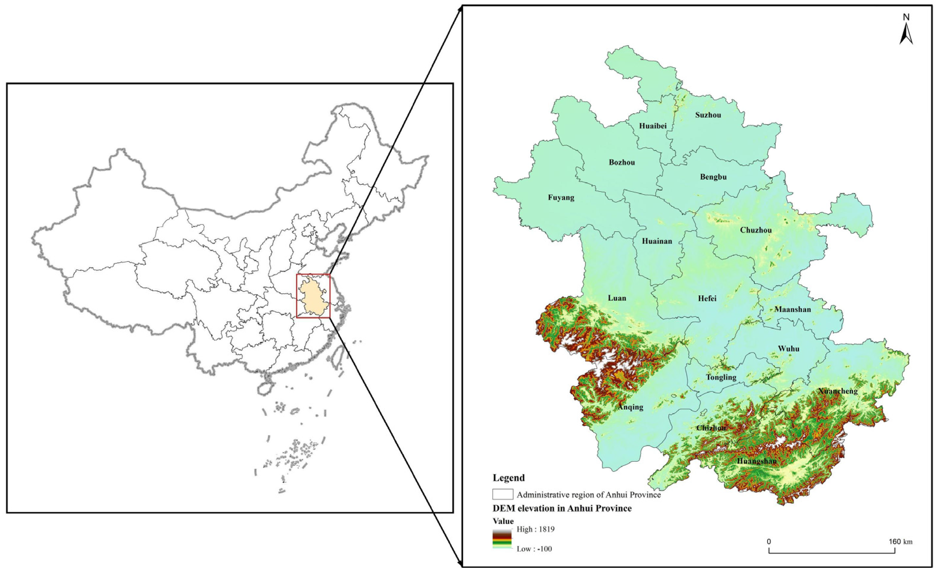
Figure 1. Location map of Anhui Province research area. Note: The geographic coordinates of this map are in WGS1984, while the projected coordinates are in WGS1984-UTM-50N.
Land 12 00994 g001
Figure 2. Three-phase diagram of the “three subsystems” of human settlement vulnerability in Anhui Province.
Land 12 00994 g002
Figure 3. Changes in human settlement vulnerability index in Anhui Province in main years.
Land 12 00994 g003
Figure 4. Spatial distribution map of vulnerability levels of human settlements in Anhui Province. Note: the geographic coordinates of this map are in WGS1984, while the projected coordinates are in WGS1984 UTM 50N.
Land 12 00994 g004
Figure 5. Main factors causing vulnerability and high vulnerability in human settlements in Anhui Province.
Land 12 00994 g005
Figure 6. Correlation analysis between the “three subsystems” of human settlement vulnerability and the human settlement vulnerability index in Anhui Province. Note: p < 0.05 is *, p < 0.01 is **, and p < 0.001 is ***.
Land 12 00994 g006
Table 1. Measurement index system of human settlement vulnerability.
Functional LayerSubsystem LayerWeight ValueSpecific Indicators (Units)Weight ValueDirection
Urban human settlement vulnerabilityExposure0.3303Per capita daily domestic water consumption X1 (liter)0.1324+
Non-point source pollution index of farmland X20.1271
Number of traffic accidents X3 (rise)0.1165
Mean noise X40.1402
Population fire incidence X5 (1/100,000 people)0.12
Total industrial exhaust emissions X6 (10,000 standard cubic meters)0.121
Total industrial wastewater discharge X7 (10,000 tons)0.1246
Industrial solid waste generation X8 (10,000 tons)0.1181
Sensitivity0.3336Annual temperature and humidity index X90.1118+
The number of days with air quality of or better than level 2 X10 (days)0.1539+
Green coverage rate of built-up area X11 (%)0.1115+
Urban population density X12 (people/km2)0.1325
Highway density X13 (km/10,000)0.1042
Degree of land use development X140.1226
Landscape sensitivity index X150.1335
Plaque density X160.13
Coping ability0.3361GDP per capita X17 (RMB/person)0.0651+
Eligible area for afforestation in that year X18 (hectares)0.1078+
Urban municipal public facility construction fixed-asset investment X19 (million CNY)0.1041+
Road area per capita x20 (sqm)0.0868+
Wastewater treatment rate X21 (%)0.0951+
Park green area per capita X22 (sqm)0.0766+
Number of urban community service facilities x23 (pcs)0.1193+
Urban water supply daily comprehensive production capacity X24 (10,000 cubic meters/day)0.1551+
Urban piped water penetration rate X25% (%)0.0948+
Urban sanitation latrine penetration rate X26 (%)0.0954+
Table 2. Single-factor detection of human settlement vulnerability.
Indicator Factor2005201020152020
ExposurePer capita daily domestic water consumption X1 (liter)0.2870.3560.1300.191
Non-point source pollution index of farmland X20.2240.1990.4030.453
Number of traffic accidents X3 (rise)0.3520.4450.2080.281
Mean noise X40.2130.1860.2730.204
Population fire incidence X5 (1/100,000 people)0.4570.2220.6150.407
Total industrial exhaust emissions X6 (10,000 standard cubic meters)0.3280.3600.4960.553
Total industrial wastewater discharge X7 (10,000 tons)0.5440.0610.2130.386
Industrial solid waste generation X8 (10,000 tons)0.1450.5380.2760.624
SensitivityAnnual temperature and humidity index X90.2780.3490.3900.326
The number of days with air quality of or better than level 2 X10 (days)0.2700.0810.0720.288
Green coverage rate of built-up area X11 (%)0.5160.3970.6770.340
Urban population density X12 (people/km2)0.4090.2450.1150.340
Highway density X13 (km/10,000)0.2980.3460.1200.407
Degree of land use development X140.0970.5260.1360.339
Landscape sensitivity index X150.3930.3340.3390.302
Plaque density X160.1560.2660.4560.503
Coping abilityGDP per capita X17 (RMB/person)0.2570.5980.3840.476
Eligible area for afforestation in that year X18 (hectares)0.5670.4990.1790.478
Urban municipal public facilities construction fixed-asset investment X19 (million CNY)0.1780.3130.2360.210
Road area per capita x20 (sqm)0.3430.0830.3590.405
Wastewater treatment rate X21 (%)0.2210.2220.1580.075
Park green area per capita X22 (sqm)0.0760.3320.2160.372
Number of urban community service facilities x23 (pcs)0.2350.1410.4560.209
Urban water supply daily comprehensive production capacity X24 (10,000 cubic meters/day)0.4060.4430.0630.319
Urban piped water penetration rate X25% (%)0.2650.4950.4240.179
Urban sanitation latrine penetration rate X26 (%)0.4880.1540.3150.145
Table 3. Interaction detection of human settlement vulnerability subsystem.
2005 AB2010 AB2015 AB2020 AB
ExposureX7X1BE (0.744)X8X1BE (0.788)X5X1NE (0.925)X8X1BE (0.841)
X7X2BE (0.723)X8X2BE (0.765)X5X2BE (0.948)X8X2BE (0.940)
X7X3BE (0.744)X8X3BE (0.730)X5X3BE (0.738)X8X3BE (0.917)
X7X4NE (0.915)X8X4NE (0.962)X5X4BE (0.778)X8X4NE (0.967)
X7X5BE (0.875)X8X5BE (0.775)X5X6BE (0.932)X8X5BE (0.907)
X7X6BE (0.809)X8X6BE (0.824)X5X7BE (0.861)X8X6BE (0.879)
X7X8NE (0.880)X8X7BE (0.674)X5X8BE (0.842)X8X7BE (0.903)
SensitivityX11X9BE (0.746)X14X9BE (0.777)X11X9BE (0.930)X16X9NE (0.998)
X11X10BE (0.771)X14X10NE (0.850)X11X10NE (0.924)X16X10BE (0.652)
X11X12BE (0.905)X14X11BE (0.890)X11X12BE (0.848)X16X11BE (0.773)
X11X13BE (0.682)X14X12BE (0.699)X11X13BE (0.871)X16X12BE (0.651)
X11X14NE (0.828)X14X13BE (0.883)X11X14BE (0.860)X16X13BE (0.769)
X11X15BE (0.742)X14X15BE (0.815)X11X15BE (0.877)X16X14BE (0.771)
X11X16NE (0.827)X14X16BE (0.840)X11X16BE (0.943)X16X15BE (0.731)
Coping abilityX18X17BE (0.858)X17X18BE (0.842)X23X17NE (0.946)X18X17BE (0.953)
X18X19NE (0.943)X17X19BE (0.721)X23X18NE (0.736)X18X19BE (0.687)
X18X20BE (0.775)X17X20NE (0.784)X23X19BE (0.626)X18X20BE (0.837)
X18X21BE (0.826)X17X21NE (0.938)X23X20NE (0.891)X18X21NE (0.920)
X18X22NE (0.822)X17X22BE (0.808)X23X21NE (0.915)X18X22BE (0.825)
X18X23BE (0.758)X17X23NE (0.942)X23X22BE (0.708)X18X23NE (0.913)
X18X24BE (0.949)X17X24BE (0.862)X23X24BE (0.591)X18X24BE (0.827)
X18X25BE (0.903)X17X25BE (0.836)X23X25BE (0.905)X18X25NE (0.934)
X18X26BE (0.977)X17X26NE (0.874)X23X26NE (0.882)X18X26NE (0.858)
Note: NE is a nonlinear enhancement; i.e., AB > A + B. BE is a two-factor enhancement; i.e., A + B > AB > A, B.
Disclaimer/Publisher’s Note: The statements, opinions and data contained in all publications are solely those of the individual author(s) and contributor(s) and not of MDPI and/or the editor(s). MDPI and/or the editor(s) disclaim responsibility for any injury to people or property resulting from any ideas, methods, instructions or products referred to in the content.