Article

Natural Hazard Characterisation in the Arribes del Duero Natural Park (Spain)

by
Leticia Merchán
1,*,
Antonio Miguel Martínez-Graña
2,
Carlos E. Nieto
2 and
Marco Criado
1
1
Department of Soil Sciences, Faculty of Agricultural and Environmental Sciences, University of Salamanca, Filiberto Villalobos Avenue, 119, 37007 Salamanca, Spain
2
Department of Geology, Faculty of Sciences, Merced Square, University of Salamanca, 37008 Salamanca, Spain
*
Author to whom correspondence should be addressed.
Land 2023, 12(5), 995; https://doi.org/10.3390/land12050995
Submission received: 26 March 2023 / Revised: 24 April 2023 / Accepted: 28 April 2023 / Published: 30 April 2023
(This article belongs to the Special Issue Geomorphology and Soils Applied to Natural Resources Sustainability)

Abstract

:
Natural disasters have been significantly affecting the natural and artificial environment for decades. For this reason, it is necessary to carry out adequate territorial planning in order to predict and mitigate possible natural risks in areas of great environmental value and interest, which is the case of the Arribes del Duero Natural Park. In order to achieve this, geotechnical mapping should be carried out followed by hazard mapping, taking into account the lithological, hydrogeological and geomorphological characteristics and, in addition, the real erosion rates. The results indicate that, in the study area, there are three areas with different geotechnical characteristics, classified according to their lithological, geomorphological and hydrological characteristics. In terms of hazards, there are five zones: with hydrological problems; lithological and geomorphological problems; geomorphological and hydrological problems; geomorphological and lithological problems; and geotechnical problems. Finally, it can be concluded that geotechnical mapping enables us to delimit areas of recommendations and limitations of use in terms of construction activities which, together with natural hazard mapping, will be very useful in the preparation of risk mapping for land-use planning.

1. Introduction

Natural disasters significantly affect the natural and man-made environment, which is why the management of natural disasters is currently a major challenge due to the different types of threats that exist [1,2]. Thus, the change of landforms due to natural disasters can affect and, in some cases, even restrict human interaction with the ecosystem [3,4,5,6,7]. Thus, to reduce the effects and socio-economic impact, adequate planning is necessary. For example, reliable information on special planning for natural disasters is a key tool for the selection of the most suitable sites for land-use development [8,9,10,11,12,13,14,15,16,17].
Geotechnical risk is a natural disaster that directly affects the ground, causing earth disturbances/movements, including earthquakes, subsidence, landslides or slope failure. These geotechnical hazards are not only triggered naturally, but some human activities can also increase their occurrence, increasing their severity. Therefore, as the natural risk cannot be avoided, human activities that may cause greater damage should be controlled. To this end, mitigation measures must be established, such as the creation of geotechnical and hazard mapping [18].
Studies of the characterization of natural hazards usually focus on the detailed examination of a single natural hazard. However, it is common for several natural phenomena to occur simultaneously or consecutively, therefore, a map would need to be created for each one, complicating their development [19]. In order to include all possible natural hazards, a simple analysis is carried out taking into account different characteristics (lithology, hydrogeology and geomorphology) and, based on these, natural hazard models are created, taking into account vulnerability and exposure to risk, through the use of geographic information systems [20,21,22].
On the other hand, the constant increase in different human activities and the commitment to protection and conservation means that sustainable development requires proper integrated territorial planning, which is a basic tool for predicting and mitigating natural risks in areas of great environmental value [23].
In order to carry out this territorial planning, some studies propose geotechnical mapping as a basic information prior to decision-making, which can prevent risk situations and can lead to significant socio-economic savings. This mapping is based on the sectoral characterization of the territory and its geomechanical behaviour in the short, medium and long term, establishing the possible natural and anthropogenic risks, as a consequence of environmental events or situations, induced by problems of geological characteristics (lithology, geomorphology and hydrogeology) [24].
In a complement to the previous mapping, and with knowledge of the geological characterization and behaviour of each material, there are also studies that carry out natural hazard mapping based on the sectoral analysis of the external geodynamic processes that can lead to a certain natural hazard [25,26]. This mapping predicts the existence of a certain risk or threshold based on a qualitative (geotechnical zoning) and quantitative (erosion rates) assessment, showing the importance of a detailed analysis of geomorphological, lithological, hydrological and geotechnical constraints in risk mapping for land-use planning [23].
The objectives of our article, in the Arribes del Duero Natural Park (Salamanca-Zamora), are: to carry out a geotechnical zoning of the territory, which allows a basic and preliminary geotechnical characterization, taking into account different factors (lithology, geomorphology and hydrogeology). On the basis of this mapping, potential natural hazards can be established by means of natural hazard mapping, in order to avoid these areas or to take the appropriate measures in the creation of different infrastructures (buildings, roads, etc.), and in addition, to avoid future natural hazards.

2. Geological and Geomorphological Context

The study area in which this study is carried out is the Arribes del Duero Natural Park (Figure 1). It is a protected area of 1061 km2 located to the west of the provinces of Salamanca and Zamora, bordering Portugal. It has a population of around 17,000 inhabitants and is made up of 38 municipalities. In terms of climate, there are two different climates: in the valley areas, it is characterised by mild winters and very hot and long summers (average temperatures of 17.1 °C and rainfall of 500 mm), while in the plains there is an extreme continental climate, with temperatures of 12.2 °C and rainfall of 750 mm. The rainiest months are March, October, November and December, and the driest are July and August. As far as snowfall is concerned, it is scarce, with only a few days in winter [27]. The river network belongs entirely to the Duero basin, whose most important tributaries, all of them on the left bank, are the Tormes, Huebra and Águeda. The landscape is characterised, on the one hand, by an undulating peneplain (with a uniform height of 700–800 m) and, on the other, by the steep slopes formed by the canyons (with heights of 130 m) carved by the river system (Duero, Tormes, Uces, Huebra, Águeda). In terms of vegetation, the peneplain is a rich mosaic, with species of the Quercus genus (oak, melojo, cork oak and gall oak), mixed with other tree species (ash) and scrub (broom and broom), pastures and dry crops (wheat, barley, rye and vines). For their part, on the slopes, on terraces, olive and almond trees remain, only displaced by myrtle, holm oak and juniper groves, where agricultural use has been abandoned [28,29]. It should also be noted that this is one of the areas with the greatest hydroelectric potential in the Iberian Peninsula, with large dams and hydroelectric power stations.

2.1. Geological Context

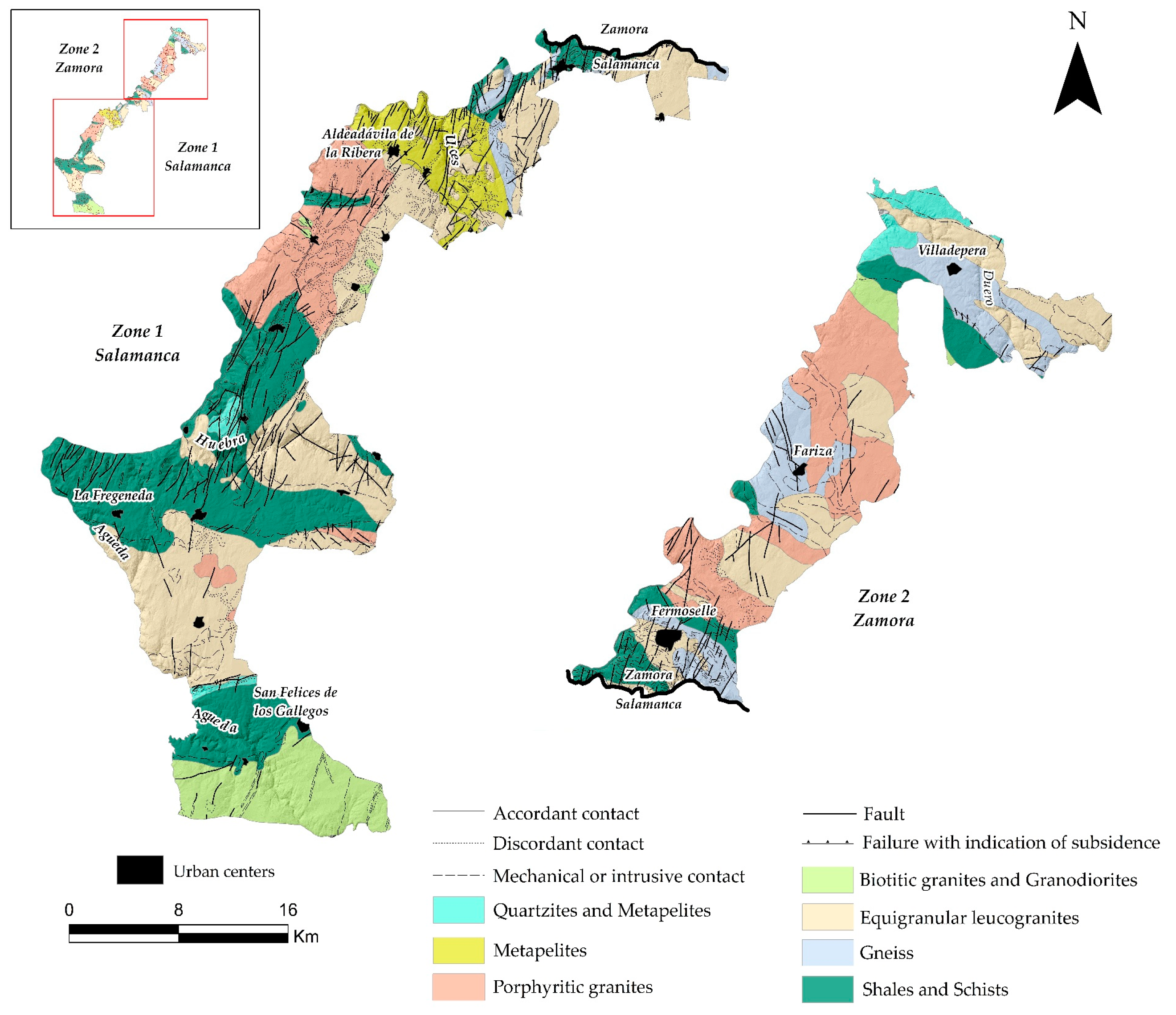
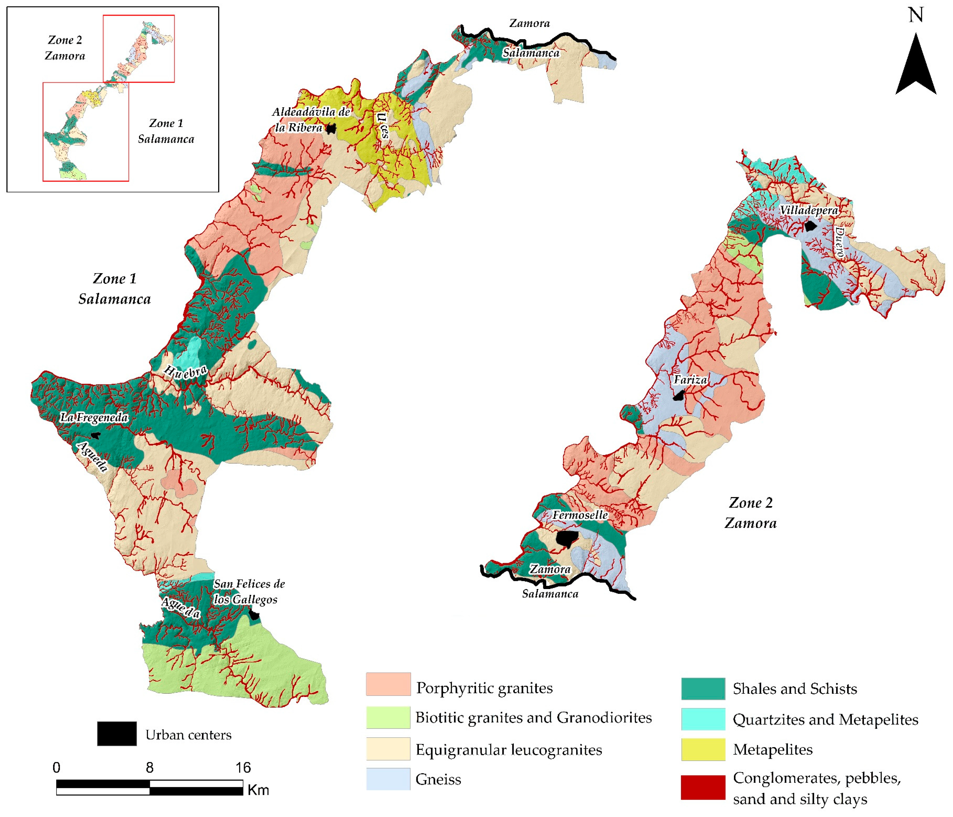
The Natural Park is part of the Central Iberian Zone of the Iberian Massif, specifically on the west edge of the “Domo del Tormes”. It is characterised by Precambrian and Paleozoic formations that were metamorphosed, deformed and intruded by plutonic granites during the Variscan orogeny. The materials affected by this orogeny are metasedimentary rocks belonging to the Upper Neoproterozoic or Lower Cambrian of the “Grauvaquian Schist Complex”, discordant in turn under the Lower Ordovician Harmonic quartzites. In the lower levels of the metasedimentary series, there are abundant fine-grained glandular orthogneisses of Prevaric age, in addition to schists and slates. The metamorphism associated with this Orogeny transforms the sedimentary sequence (shales, schists and paragneisses) into metapelites and gneisses, reaching a partial merger with the generation and intrusion of anatectic granites (Figure 2). Tectonically, we can find concordant, discordant, mechanical or intrusive contacts, as well as faults and faults with indications of subsidence [30,31,32,33,34,35].
The acid rocks include a wide variety of leucogranites, biotitic granites. The former is porphyritic, two-mica, equigranular, fine-to coarse-grained, the latter may sometimes have tourmaline, garnet or cordierite and anatectic origin. Biotitic granites are always porphyritic and may (not always) have muscovite and/or cordierite. On the other hand, there are also intermediate and basic rocks that are related to the above, varying in composition from diorites and monzonites to tonalites and granodiorites [30,36,37].
As far as sedimentary rocks are concerned, there are slate, schist and paragneiss units, mainly clayey slate, chlorite and graphite schists, quartzite and conglomerate. The more frequent paragneiss, on the other hand, are biotite gneisses with marked schistosity and glandular [36,37].
There is also representation of metamorphic rocks such as quartzites, belonging to the Ordovician, with white and yellowish tones, sometimes reddish due to iron oxide staining, which stand out against the surrounding terrain [30,35].
Likewise, in the fluvial network of river beds and riverbeds, deposits of materials such as conglomerates, pebbles, sands and silty clays are characteristic. The former is coarse to very coarse-grained detrital materials, poorly stratified and semi-dissolved, reddish or yellowish-brown in colour. The cobbles, on the other hand, are generally loose and are the product of the erosion of the Paleozoic mountainous reliefs, being of a quartz and quartzite nature and, to a lesser extent, cornubianites and slates [37].
Finally, the granitic and metamorphic basement is affected in its entirety by alpine faults, with a NE-SE or NNE-SSW direction, which condition the subsequent conditioning of the fluvial network. Some of these faults are associated with large quartz veins which form morphostructural alignments of mountain ranges in the peneplain, made up of milky quartz, sometimes marbled. Because of their resistance to erosion, they stand out clearly in the landscape, commonly known as “sierros” [37].

2.2. Morphostructural Context

In terms of geomorphology, most of the Arribes del Duero is located in the so-called “Zamorano-Salmantina peneplain”, with a hilly to undulating shape, derived from the erosive processes of alteration, washing and fluvial erosion. It could be considered as a large surface area but, in reality, it is a multi-cyclic and staggered group, formed as a consequence of a relative lowering of the base level, rejuvenation of the network and reactivation of the landscape. In this way, six levels or erosional surfaces have been differentiated that are distributed gently staggered towards the west, a consequence of the tilting of the Meseta towards the Atlantic and, therefore, with ages later than the Oligocene [38].
In addition to these erosive surfaces, some residual reliefs in the form of island mountains, known as inselbergs, stand out topographically and in isolation from the monotonous profile of the peneplain. These have been formed due to the differential erosion, over long periods of time, of various morphogenetic processes typical of subtropical palaeoclimatic conditions. The inselbergs that can be distinguished in the area are flat-topped, conical and domical [38,39].
Other polygenic forms can also be observed, such as pediments and blockfields. The former are characterised by a gentle slope (no steeper than 5 degrees), which serves as a link between the river beds and the replans of steeper surfaces. Blockfields, on the other hand, are characterised by the concurrence of two or more types of cleavage, generally curved and subvertical, the former giving rise to lanchars and the latter generating parallelepiped blocks which, by granular disaggregation and flaking, produce granitic boulders [36].
With regard to the forms of slope, we can differentiate between escarpments, colluviums, slopes, valleys, incised valleys and the Duero river, known as the “arribe” or fluvial canyon. The first ones appear when there is a change of slope, the colluviums present a varied lithology depending on the materials that make up the substratum. The slopes are those areas where there is already a slight slope but without forming a valley. On the other hand, regarding the difference between valleys and incised valleys, in addition to presenting a clear V-shape, the former are attributed to less abundant streams or rivers and the latter to more abundant rivers, which give rise to more defined valleys but without reaching the boxing of the Duero [39].
The fluvial forms existing in the area are floodplain, which are areas of scarce development; terraces, which are deposits made up of silts and sands; cones of dejection, which are the product of the discharge of materials; abandoned meanders, which correspond to old valleys, abandoned by rivers or streams due to changes in the longitudinal profile; and, finally, aluvial fan (“rañas”), which are a mixture of colluvial and fluvial deposits of the floodplain, their lithology are sands and quartz and quartzite pebbles, of variable dimensions, generally loose, products of the erosion of the Paleozoic mountainous reliefs [39].
There are also endorheic forms, specifically navas. These are depressed areas of great extension and are associated with water retention phenomena, decantation, the development of hydromorphism and the generation of soils [39].
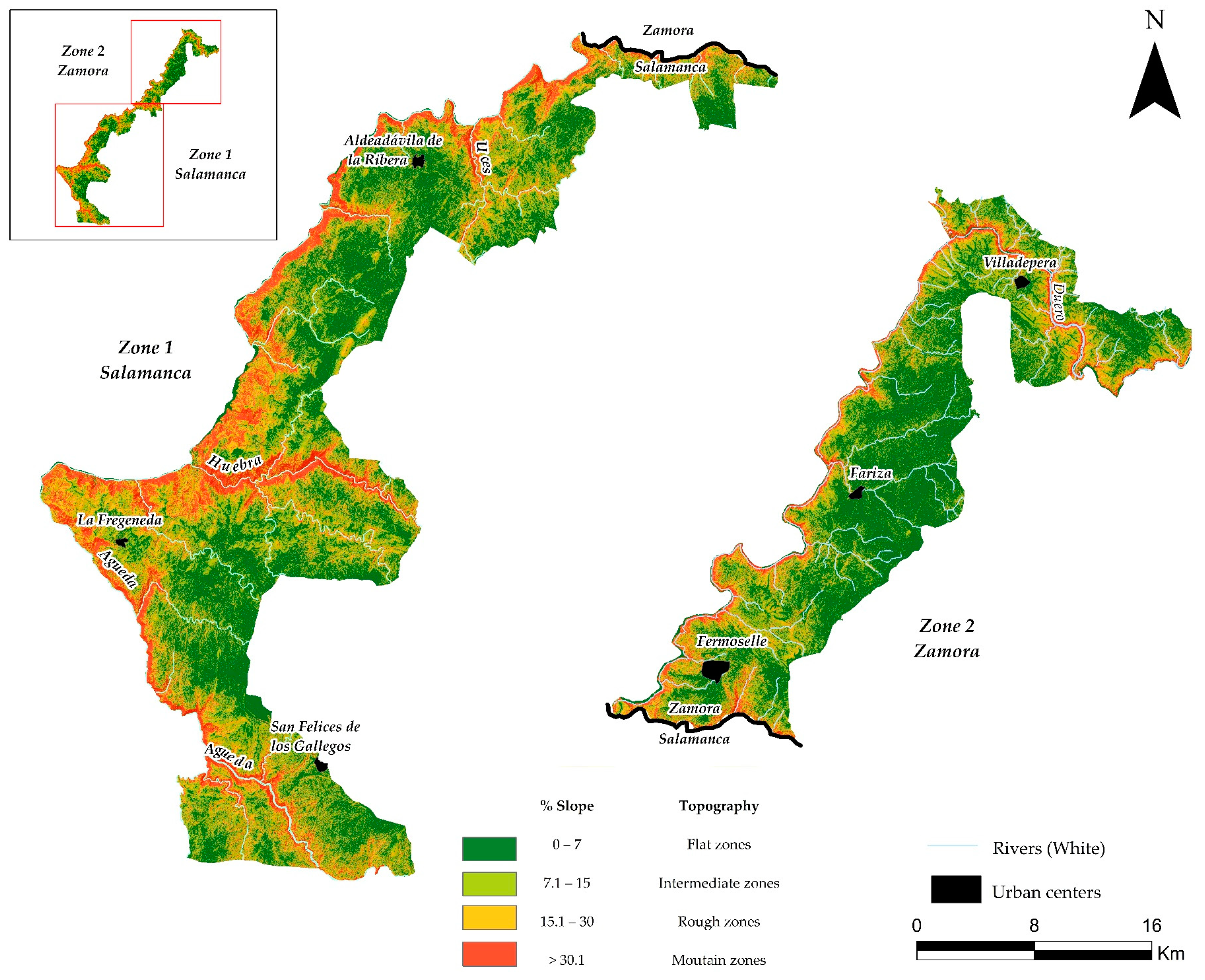
Finally, topographically, we can find different areas: flat, with slopes of 0 to 7%, i.e., erosion surfaces; intermediate areas, with slopes of 7 to 15%, corresponding to the slopes or glaciers; and steep areas with slopes of over 15%, such as the valleys of the Duero river (Figure 3) [37].
The hydrographic network belongs to the Duero hydrographic basin, the most important watercourses being, logically, the Duero, which borders Portugal at its north-western end, and its tributaries Tormes, Huebra and Águeda [37].
In terms of surface runoff, this can be considered good, except in localised areas. On the other hand, infiltration is very superficial due to the existence of impermeable rocks/soils substrates. The most permeable areas correspond to the floodplain [37].

3. Materials and Methods

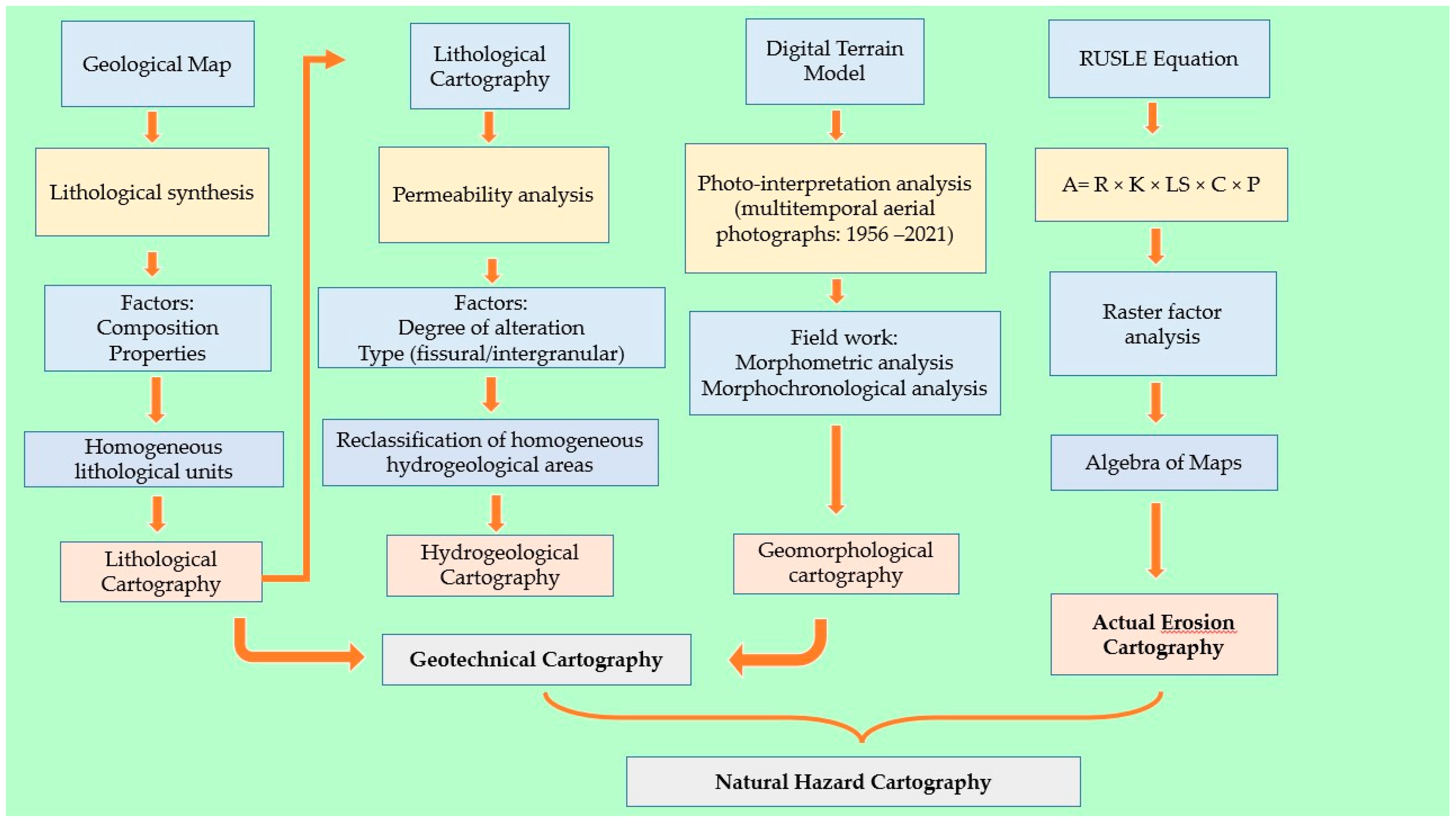
The methodology followed in this article (Figure 4), combines field work with desk research, from which a series of cartographies are obtained that serve to establish the natural hazards and risks, in order to take measures to avoid them. The desk research focuses on the study of photographs, thematic maps and existing studies. All this information is contrasted with field work, by obtaining data such as lithological resistance using the Schmidt hammer or sclerometer, as well as observation and subsequent taking of photographs. In this way, to update and validate these data, tools from current methodologies have been used, such as the survey of four types of geomechanical station for each lithology [40,41,42].
In this way, considering the information previously indicated, the initial thematic cartographies (lithological, hydrogeological and geomorphological) are made, which in turn form the basis of the two final cartographies: “Geotechnical Cartography” and “Risk Cartography”. The implementation of a Geographic Information System (ArcGis 10.8) has made it possible to work with georeferenced digital thematic layers.
The Geotechnical Cartography has been carried out by superimposing a series of thematic cartographies that will serve to establish territorial zoning categories, based on the grouping of homogeneous characteristics, where the response of the terrain can be similar according to its geotechnical behaviour [20,22]. They can be categorized as follows:
  • Lithological mapping: to make this map we have based ourselves on the grouping of areas that have similar characteristics in terms of composition and geomechanical behaviour. As for the characterization of the substratum, the existing geological maps have been used as a basis, grouping the materials according to composition and properties to create homogeneous areas. In the study area, there are three zones that have been classified, according to the age of the rocks that form them, as follows: Area I made up of plutonic outcrops (granites and gneisses); Area II corresponds to the Lower Paleozoic (metamorphic rocks); and Area III made up of Quaternary deposits (conglomerates, pebbles, sand and silty clays).
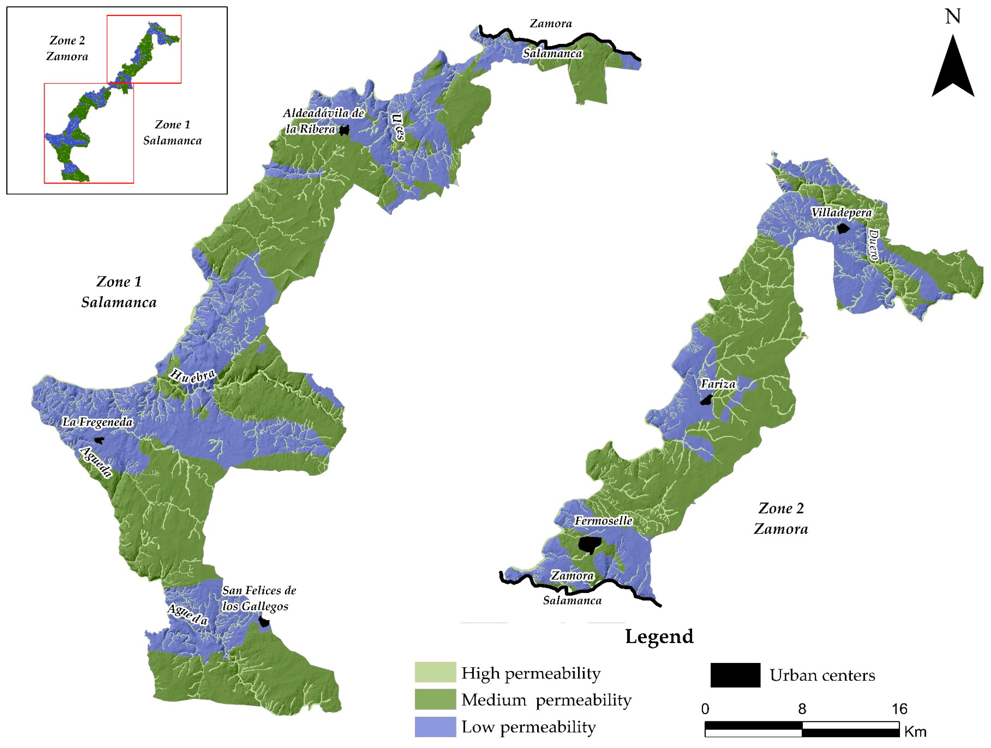
  • Hydrogeological mapping: this map has been made considering the characterization of the materials from the point of view of lithology and hydraulic parameters. For this purpose, the three previous areas have been reclassified according to the degree of alteration (high, medium and low) and type of permeability (by porosity, fracturing, dissolution and alteration).
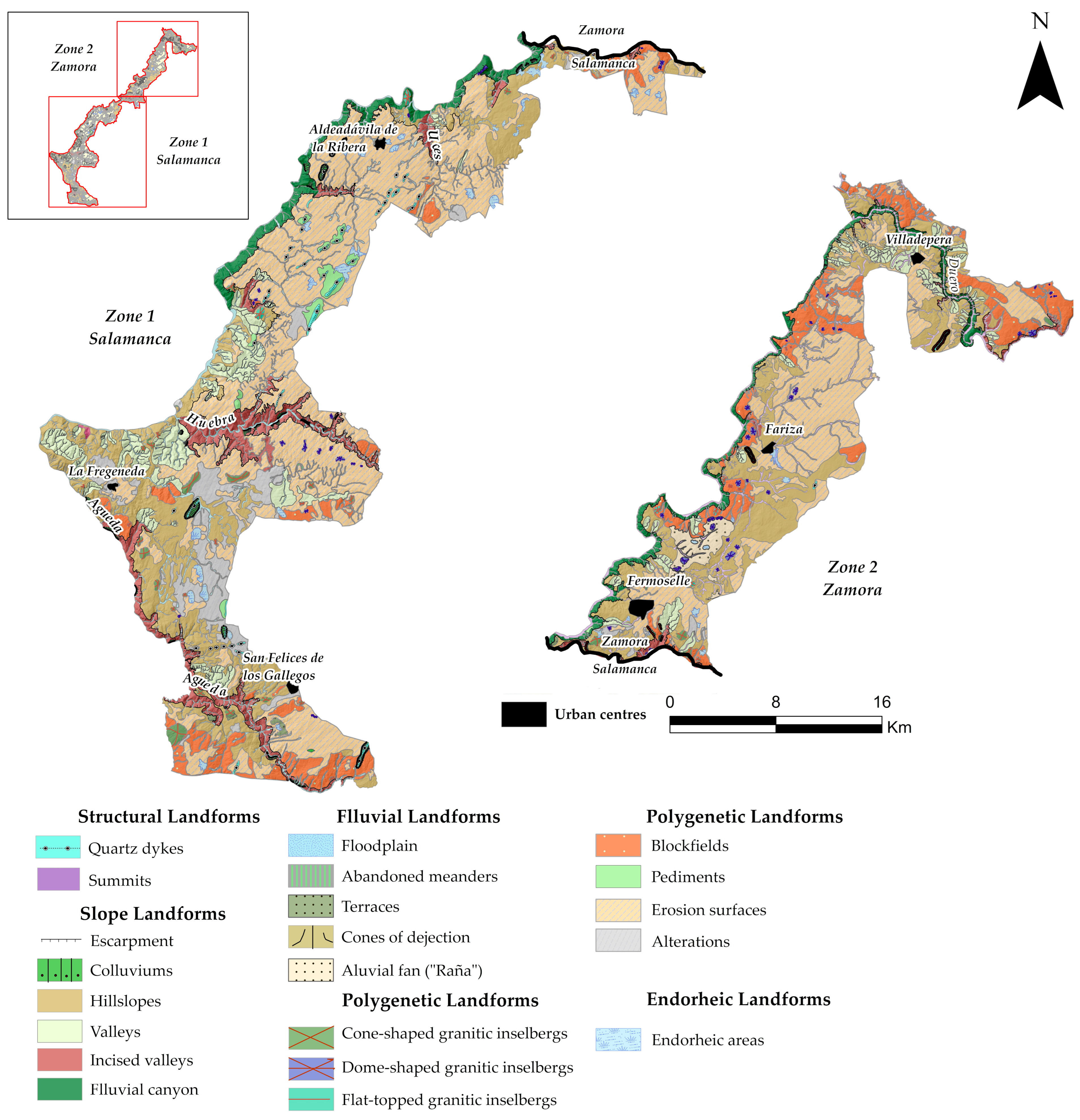
  • Geomorphological mapping: the main morphological features that indicate their possible repercussions on the behaviour of the terrain have been taken into account, as well as the 1 m digital terrain model and the interpretation of aerial photographs and existing maps. Once this cartography has been carried out, a synthesised map is made with the fundamental aspects of the relief, in order to indicate only the most relevant physiographic characteristics, which can influence the geotechnical characterization and grouping of similar morphologies.
  • Actual Erosion Mapping: this is carried out on the basis of potential erosion mapping, which is obtained by multiplying three of the factors that make up the universal soil loss equation (RUSLE): R factor (erosivity), K factor (erodibility) and LS factor (slope). For the R factor, the average annual and monthly rainfall is taken into account, for the R factor, the granulometric characteristics of the soil and, for the LS factor, the length and steepness of the slope. Once this mapping has been obtained, the actual erosion mapping is carried out, taking into account the two remaining factors of the RUSLE: factor C (vegetation cover) and factor P (conservation practices). This mapping, together with the land uses, is useful to determine the conservation practices needed to mitigate erosion losses.
Natural Hazard Mapping, on the other hand, is based on the sectoral analysis of external geodynamic processes that can potentially lead to active processes. This mapping predicts, spatially, the existence of a certain hazard risk, based on geotechnical zoning and erosion rates [19,20]. In this way, it considers the Geotechnical Mapping carried out previously and the existing erosion map [37], which serves to add the risk of soil loss to the areas subject to other geomorphological, hydrological and geotechnical risks [19,20].

4. Results

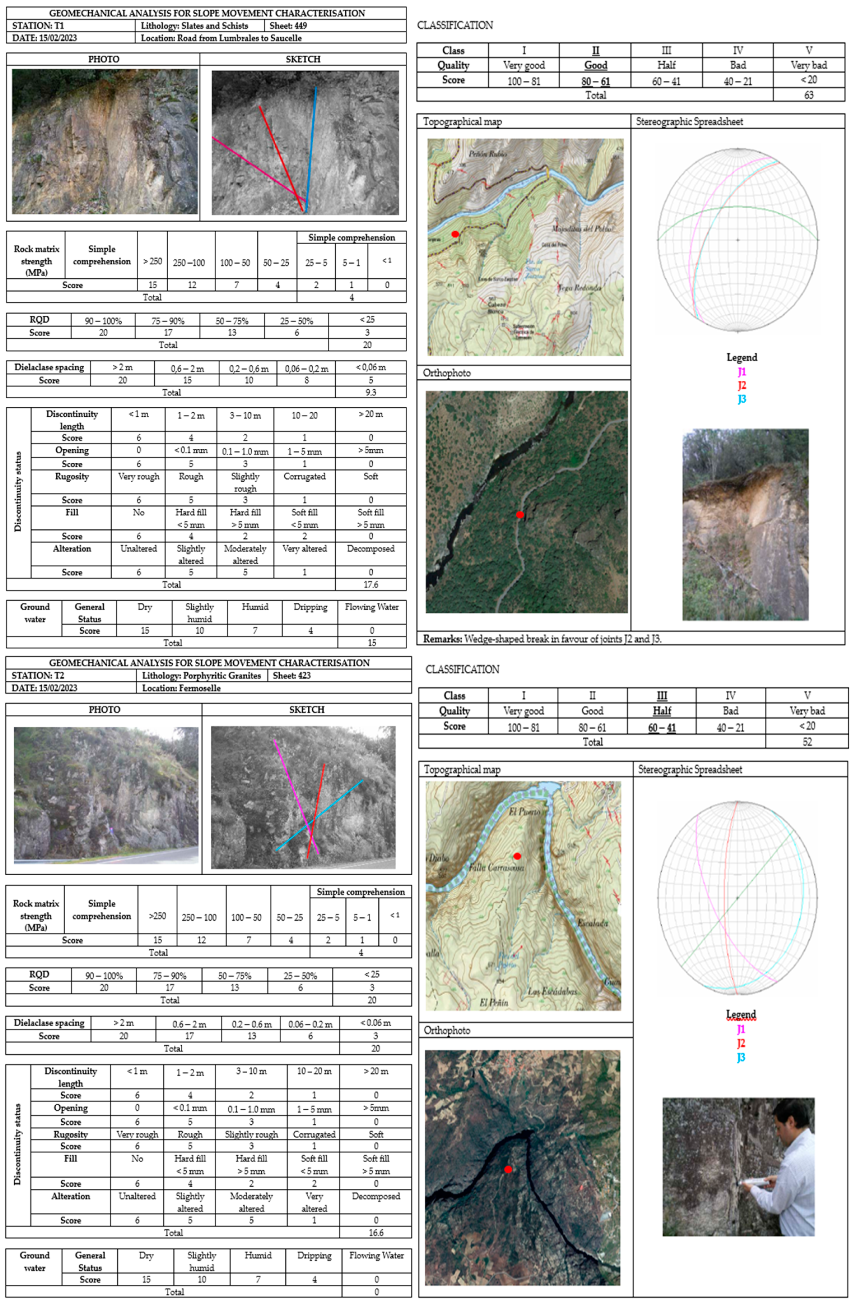
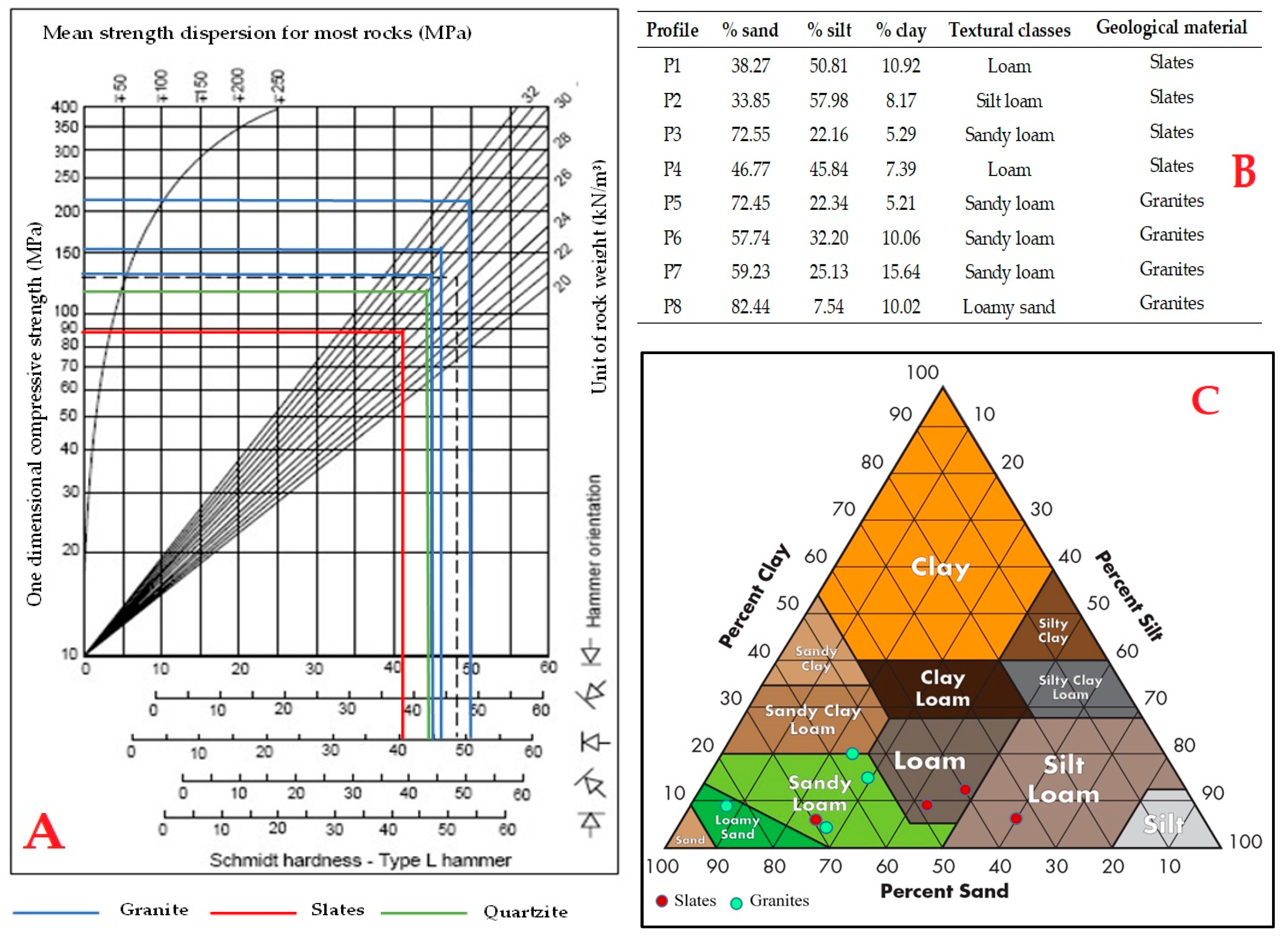
In the study area, given its extension, we have installed four mechanical stations, the cards of two of them, specifically, one located on porphyritic granites and the other on slates and schists (Figure 5). Next, the resistance of the rock matrix is characterised by calculating the simple compression with the sclerometer or the Schmidt hammer (Figure 6A), as well as obtaining other useful data (Figure 6B,C).

4.1. Geotechnical Cartography

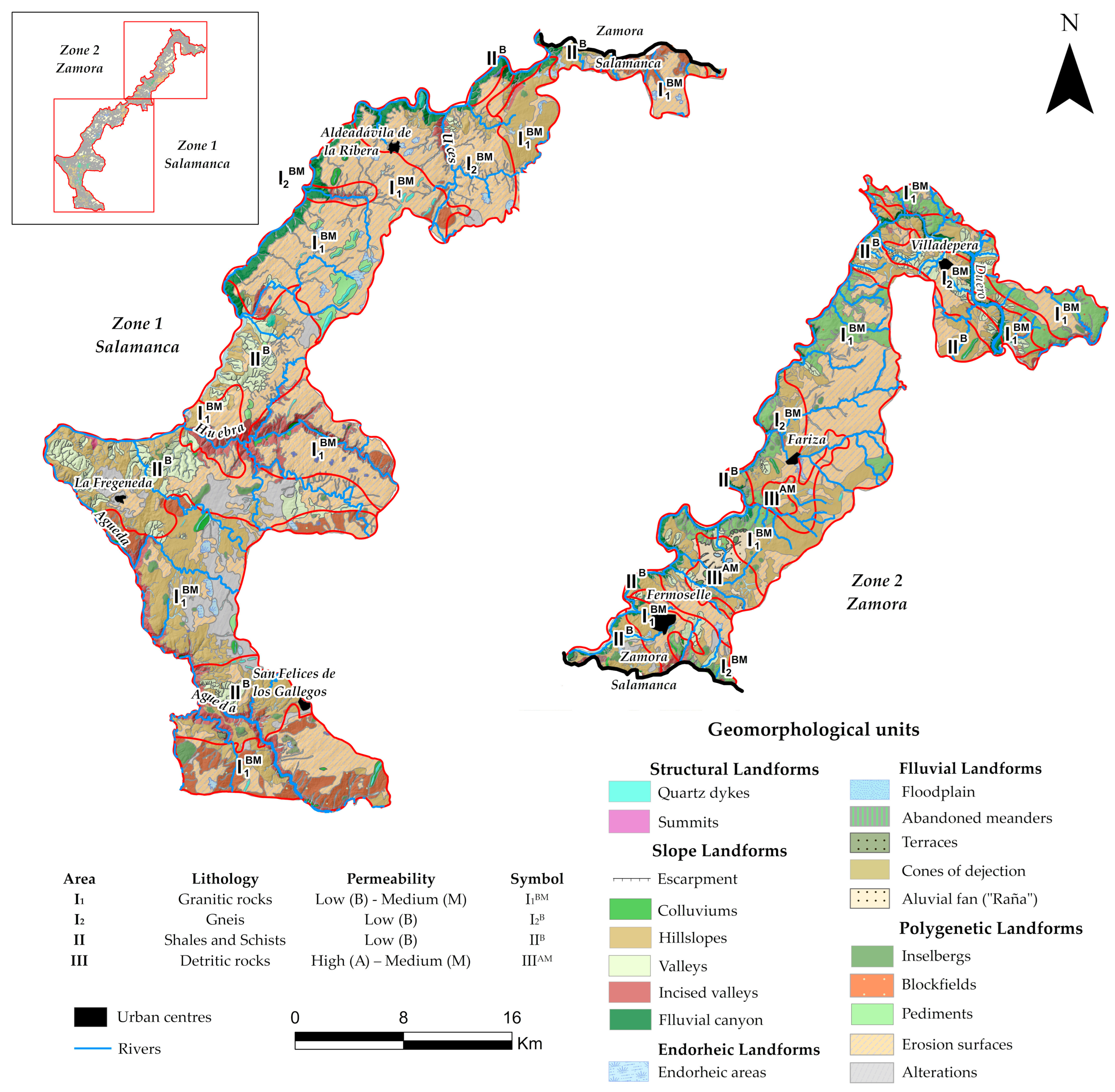
The Geotechnical Cartography has been made from the superposition of the lithological (Figure 7), hydrogeological (Figure 8) and geomorphological (Figure 9) cartographies, differentiating three areas that have been grouped according to homogeneous characteristics. The areas are described below (Figure 10):
Area I1: from the lithological point of view, it corresponds to granitic outcrops (equigranular leucogranites, biotitic granites and granodiorites, porphyritic granites) with textures varying from fine-grained to porphyritic. It is frequent that the mass is crossed by dykes and veins of aplite pegmatites and quartz. In terms of geomorphological characteristics, the area is generally flat, with the exception of the western edge, in the vicinity of the Duero, which is steep. In addition, there are numerous outcrops, giving rise to the morphology typical of these, with extensive, hilly crags. Overall, taking into account the two previous characteristics, this area is considered to be stable. In terms of hydrogeological characteristics, it is considered to be impermeable material with a semi-permeable granular coating, with scarce internal drainage due to fracturing and diaclasation and acceptable external drainage due to active surface runoff. Thus, considering the above and after superimposing the different cartographies, we can conclude that the geotechnical characteristics of this area have a high load capacity and no foreseeable settlements.
Area I2: in contrast to the previous one, the outcrops in this area are scattered and consist of glandular gneisses and micacites. In terms of geomorphological characteristics, it has a flat topography, with slopes of less than 7%, except in the Duero river junction, which gives rise to a sharp drop in slope. Thus, taking into account the lithological and geomorphological characteristics, this area is considered to be stable. The hydrogeological characteristics indicate that they are impermeable on a large scale, although with a certain degree of internal drainage due to fractures and diaclases, with the presence of a more or less accentuated porosity. As far as drainage is concerned, it is good by active surface runoff. Thus, taking into account the above, the geotechnical characteristics of this area, similar to I1, present a high load-bearing capacity in areas of sound rock. However, if the foundations are laid on fractured areas, the bearing capacity can be significantly reduced, and therefore the settlement cannot be of high altitude.
Area II: the lithology corresponds to Palaeozoic metasediments, made up of slate, schist, greywacke, quartzite and limestone. It has a flat topography, with the exception of the Duero river, where it becomes abrupt. The slate materials make this area unstable, without ruling out strong instability phenomena such as landslides. As for the hydrogeological characteristics, these are impermeable materials, with clay-loam textured soils, with very little internal drainage and active surface runoff. Finally, the geotechnical characteristics observed indicate that this area presents materials with a high load-bearing capacity although, due to the degree of fracturing and slate in the area, the existence of weak zones is possible.
Area III: the characteristic materials are a series of isolated quaternary outcrops, corresponding to the alluvial ones, with granular materials and with a variable percentage of silt and clay, generally loose, linked to the fluvial network, not presenting lithological problems. In terms of geomorphological characteristics, it is characterised by a flat topography with good stability. In terms of hydrogeological characteristics, the materials are generally permeable with variable internal drainage due to intergranular porosity, which varies according to the percentage of clays. Surface runoff is acceptable to favourable, with alluvial deposits being the worst. Finally, the geotechnical characteristics have a bearing capacity ranging from medium to low, which will depend on the lithological composition and the position of the water table.

4.2. Natural Hazard Cartography

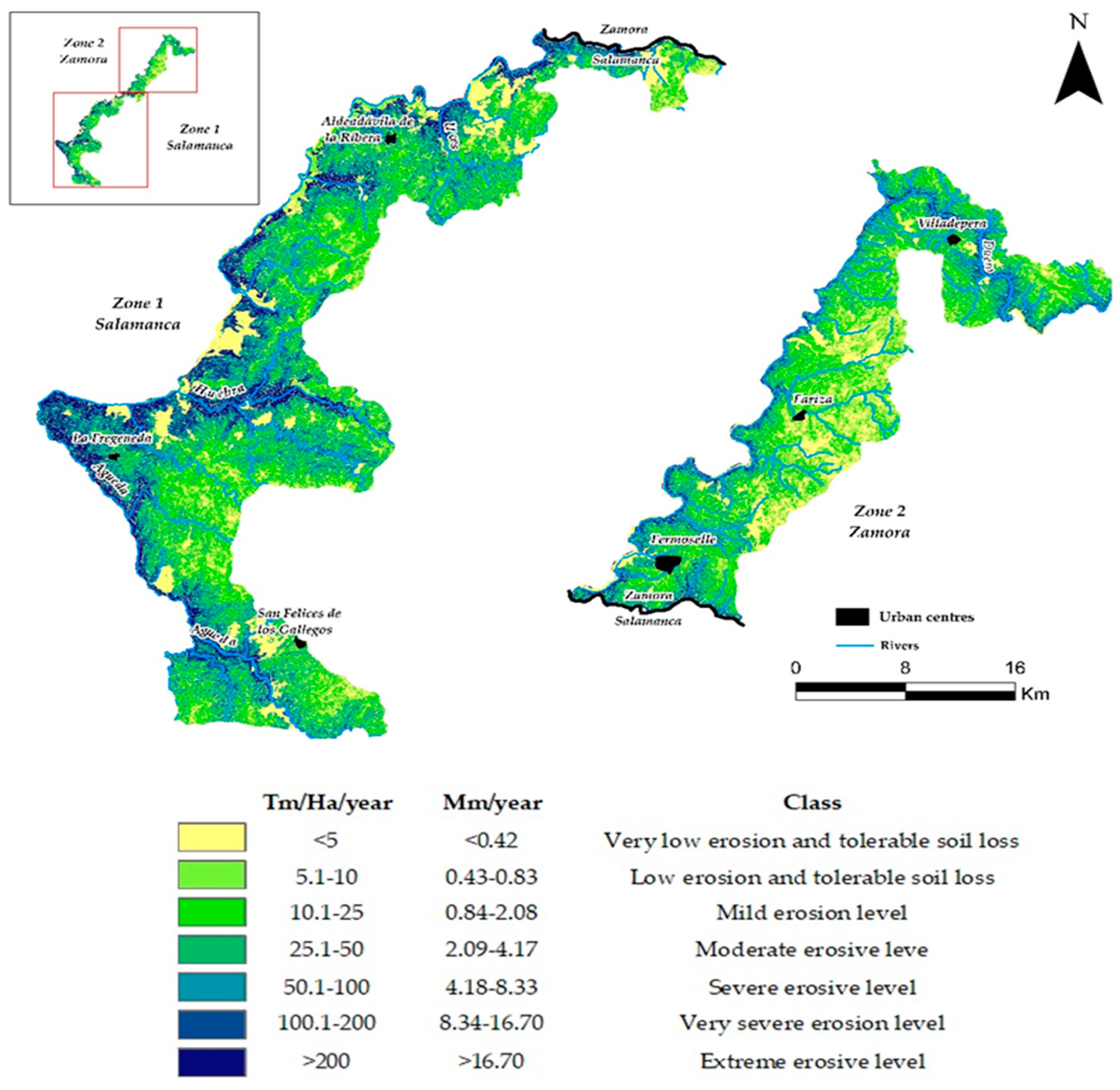
This mapping has been carried out on the basis of the interpretation of the previous geotechnical mapping and considering the actual erosion mapping (Figure 11) [43]. In this way, it is possible to establish the different problems that may arise most frequently, as well as the determining aspects of their evaluation.
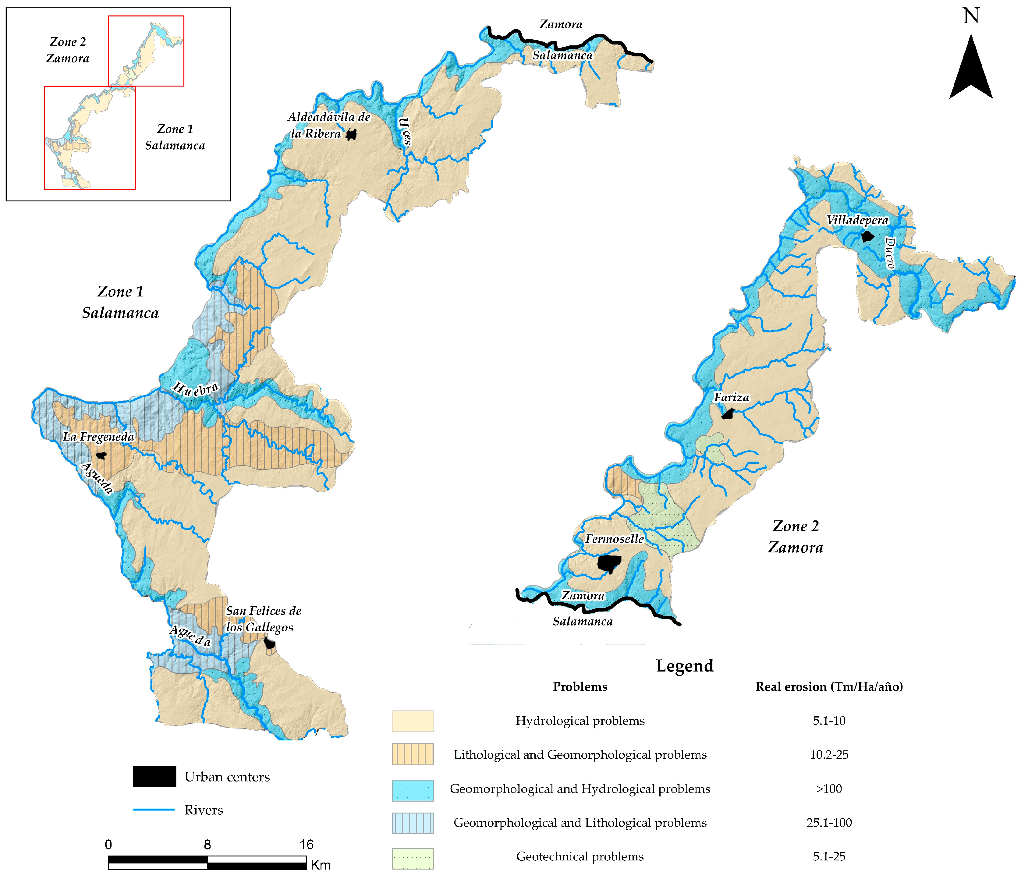
In the Arribes del Duero Natural Park there are five types of problems: hydrological problems; lithological and geomorphological problems; geomorphological and hydrological problems; geomorphological and lithological problems; and geotechnical problems.
The types of problems observed in the study area and their associated mapping are described as follows (Figure 12):
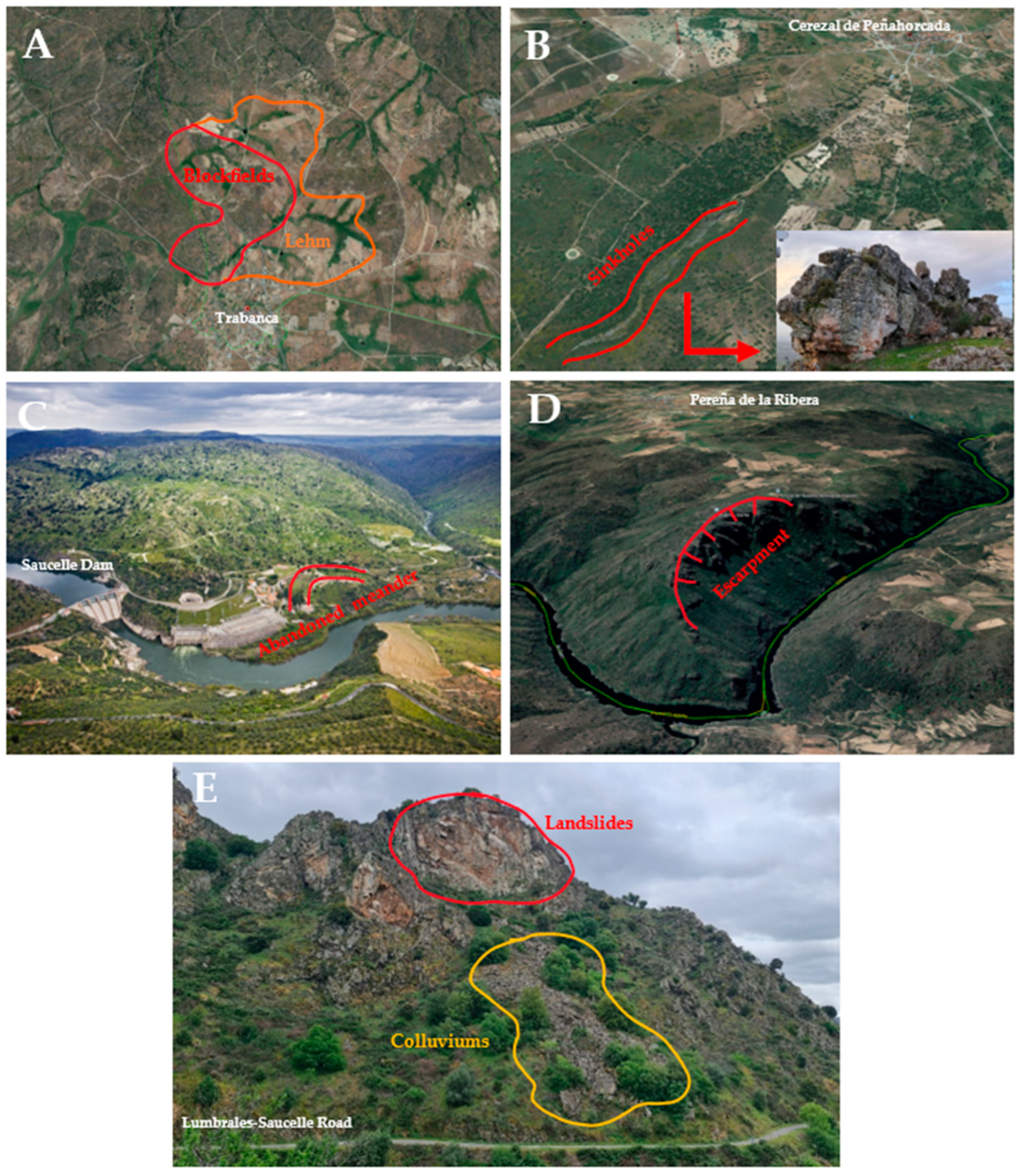
Hydrological problems: these occur in a large part of Area I1 and I2, whose materials are impermeable, with semi-permeable granular coatings. As far as surface runoff is concerned, it is active in a large part of the area, therefore, the possible problems would be very localised. In terms of erosion rates, these areas are considered tolerable soil losses (5.1–10 Tm/Ha/year), thanks to the fact that the existing vegetation is of high density and herbaceous cover and, in addition, with more developed soils whose intrinsic characteristics provide greater protection against possible erosion. For example, in the locality of Trabanca, we can observe a blockfield followed by a lehm, the first one composed of granitic boluses that have resisted weathering, whereas the second one is alteration material with a sandy appearance, formed as a consequence of the penetration of water through the fractures in the granites, favouring the processes of chemical and physical weathering (hydrolysis, hydroclastia, dissolution, etc.) (Figure 13A).
Lithological and geomorphological problems: lithological problems predominate, due to the fact that, although the materials are impermeable, there may exist planes of weakness such as diaclases, fractures or slate that cause instability but under the action of man. In the case of quartzite levels, there are excavation and drilling problems due to their hardness. In terms of geomorphological problems, these occur in areas with a slight slope and average erosion rates (10.1–25 Tm/Ha/year). Unlike the previous ones, the soils are of medium development, with a lower percentage of herbaceous cover, giving the soil less protection, which is why the reason for noticeable greater erosion losses. For example, the Sierro de Peñahorcada is formed by the filling of old fractures with quartz, highlighting the landscape and presenting a very good geotechnical resistance and quality of the massif (Figure 13B).
Geomorphological and hydrological problems, which correspond to Areas I1 and I2 but are located in areas of steep slopes, caused by the confinement of the fluvial network, especially of the Duero river. There may be problems of instability under the action of man, favoured by the presence of covering materials of an arcosic nature, with a greater or lesser clay content, and also by surface infiltration of runoff water.
In terms of erosion rates, we find values of over 100 Tm/Ha/year, which is considered a severe-extreme erosive level, largely due to the high slopes, which is why geomorphological problems predominate over hydrological ones and, furthermore, with vegetation of little protective power and low coverage percentages, thus further accentuating the vulnerability of the soils which are already underdeveloped. For example, as a consequence of the silting up of the Duero river and erosive processes, we can observe abandoned meanders such as the Saucelle dam (Figure 13C) or also rotational and gravitational landslides (Figure 13D) and landslides (Figure 13E).
Geomorphological and lithological problems, with materials from Area II, also located in areas of steep slopes topography and due to the presence of planes of weakness caused by slate, diaclases, faults, etc. All of this conditions the possible existence of instabilities under the action of man, due to the fact that it breaks the complicated established equilibrium. With regard to erosion rates, it is possible to observe areas with moderate and medium erosion levels, with values between 25.1 and 100 Tm/Ha/year, located in areas with lower slopes, with respect to the previous one, where soils of intermediate development predominate, with more clay content and a vegetation with greater coverage, making them less susceptible to erosion.
Geotechnical problems are observed in a small area near Fermoselle and correspond to Quaternary materials, i.e., Area III. These are loose, permeable, sandy materials with a low load capacity. The erosion levels in this area are characterised by low to medium erosion levels, with values between 5.1 and 25 Tm/Ha/year, with poorly developed soils and dense vegetation and acceptable coverage, in addition to low slopes.

5. Conclusions

At present, special planning comprises numerous GIS resources (orthophotos, metric and centimetric lidar models, the use of UAVs, etc.) which, implemented in GIS, allow a simple analysis of the different natural processes. Geotechnical mapping makes it possible to establish basic information prior to decision-making by means of natural hazard mapping. In this way, geotechnical mapping has been carried out in the Arribes del Duero Natural Park, based on the detailed analysis of the lithological, hydrogeological and geomorphological characteristics and, subsequently, the natural hazard mapping, focused on the correct territorial planning.
In the geotechnical mapping, we have differentiated three geotechnical areas, grouped according to homogeneous lithological, hydrological and geomorphological characteristics. Area I1, made up of granitic, impermeable and semi-permeable rocks, with a high load capacity, has favourable to acceptable geotechnical characteristics. Area I2 is made up of gneisses with low permeability, topographically located in stable areas, with a high load capacity in geotechnical terms. On the other hand, Area II, with slate type rocks, impermeable, with variable topography (flat and sloping areas), with high load capacity. Finally, Area III, made up of a series of Quaternary outcrops, with high and medium permeability, with medium to low bearing capacity.
In the natural hazard mapping, five types of problems can be listed as follows: hydrological problems; lithological and geomorphological problems; geomorphological and hydrological problems; geomorphological and lithological problems; and geotechnical problems. These problems have been classified and distinguished according to their lithological, hydrological and geotechnical characteristics and, in addition, the real erosion rates have been taken into account. The hydrological problems are the most extensive, occupying most of the eastern part of the study area, coinciding with the flat areas. The lithological and geomorphological problems are concentrated between the town of La Fregeneda and the river Huebra, with higher slopes. The geomorphological and hydrological problems are located in the steeper areas, i.e., in the Duero river canyon or in the valleys of the tributaries such as the Huebra, Águeda or Tormes. Likewise, in areas of steep slopes, although with valleys that are not embedded, such as in the area around La Fregeneda. Finally, the geotechnical problems are the least extensive, being located in a limited area to the south of Fermoselle. Finally, it is important to highlight that the geotechnical mapping would allow us to delimit areas of recommendations and limitations of uses in terms of construction activities and the mapping of natural hazards, which will allow us to establish a potential risk mapping method for rational and sustainable territorial planning.

Author Contributions

Conceptualisation, L.M., A.M.M.-G., M.C. and C.E.N.; methodology, L.M.; software, L.M. and A.M.M.-G.; validation, L.M. and A.M.M.-G.; formal analysis, L.M., A.M.M.-G., M.C. and C.E.N.; investigation, L.M. and A.M.M.-G.; resources, L.M., A.M.M.-G., M.C. and C.E.N.; data curation, L.M. and A.M.M.-G.; writing—original draft preparation, L.M. and A.M.M.-G.; writing—review and editing, L.M. and A.M.M.-G.; visualisation, L.M. and A.M.M.-G.; supervision, A.M.M.-G.; project administration, A.M.M.-G.; funding acquisition, A.M.M.-G. All authors have read and agreed to the published version of the manuscript.

Funding

Grant 131874B-I00 funded by MCIN/AEI/10.13039/501100011033.

Data Availability Statement

Not applicable.

Acknowledgments

This research was assisted GEAPAGE research group (Environmental Geomorphology and Geological Heritage) of the University of Salamanca.

Conflicts of Interest

The authors declare no conflict of interest.

References

  1. De Silva, M.; Kawasaki, A. Socioeconomic vulnerability to disaster risk: A case study of flood and drought impact in a rural Sri Lankan community. Ecol. Econ. 2018, 152, 131–140. [Google Scholar] [CrossRef]
  2. Skilodimou, H.D.; Bathrellos, G.D.; Chousianitis, K.; Youssef, A.M.; Pradhan, B. Multi-hazard assessment modeling via multi-criteria analysis and GIS: A case study. Environ. Earth Sci. 2019, 78, 47. [Google Scholar] [CrossRef]
  3. Skilodimou, H.D.; Bathrellos, G.D.; Maroukian, H.; Gaki-Papanastassiou, K. Late Quaternary evolution of the lower reaches of Ziliana stream in south Mt. Olympus (Greece). Quat. Phys. Geogr. Dyn. 2014, 37, 43–50. [Google Scholar]
  4. Bathrellos, G.D.; Skilodimou, H.D.; Maroukian, H. The spatial distribution of Middle and Late Pleistocene cirques in Greece. Geogr. Ann. Ser. A Phys. Geogr. 2014, 96, 323–338. [Google Scholar] [CrossRef]
  5. Bathrellos, G.D.; Skilodimou, H.D.; Chousianitis, K.; Youssef, A.M.; Pradhan, B. Suitability estimation for urban development using multi-hazard assessment map. Sci. Total Environ. 2017, 575, 119–134. [Google Scholar] [CrossRef] [PubMed]
  6. Bathrellos, G.D.; Skilodimou, H.D.; Maroukian, H. The Importance of Tectonism in the Greek Glaciations. Geol. Soc. London Spec. Publ. 2017, 433, 237–250. [Google Scholar] [CrossRef]
  7. Bathrellos, G.D.; Skilodimou, H.D.; Maroukian, H.; Gaki-Papanastassiou, K.; Kouli, K.; Tsourou, T.; Tsaparas, N. Pleistocene glacial and lacustrine activity in the southern part of Mount Olympus (central Greece). Area 2017, 49, 137–147. [Google Scholar] [CrossRef]
  8. Abdulwahid, W.M.; Pradhan, B. Landslide vulnerability and risk assessment for multi-hazard scenarios using airborne laser scanning data (LiDAR). Landslides 2017, 14, 1057–1076. [Google Scholar] [CrossRef]
  9. Althuwaynee OF, Pradhan B Semi quantitative landslide risk assessment at Kuala Lumpur Metropolitan City using GIS and exposure-based analysis. Geomat. Nat. Hazards Risk 2016, 8, 706–732.
  10. Bathrellos, G.D.; Kalivas, D.P.; Skilodimou, H.D. GIS-based landslide susceptibility mapping models applied to natural and urban planning in Trikala, Central Greece. Geol. Stud. 2009, 65, 49–65. [Google Scholar] [CrossRef]
  11. Rozos, D.; Skilodimou, H.D.; Loupasakis, C.; Bathrellos, G.D. Application of the revised universal soil loss equation model on landslide prevention. An example from N. Euboea (Evia) Island, Greece. Environ. Earth Sci. 2013, 70, 3255–3266. [Google Scholar] [CrossRef]
  12. Youssef, A.M.; Pradhan, B.; Al-Kathery, M.; Bathrellos, G.D.; Skilodimou, H.D. Assessment of rockfall hazard at Al-Noor Mountain, Makkah city (Saudi Arabia) using spatio-temporal remote sensing data and field investigation. J. Afr. Earth Sci. 2015, 101, 309–321. [Google Scholar] [CrossRef]
  13. Skilodimou, H.; Livaditis, G.; Bathrellos, G.; Verikiou-Papaspiridakou, E. Investigating the flooding events of the urban regions of Glyfada and Voula, Attica, Greece: A contribution to Urban Geomorphology. Geogr. Ann. Ser. A Phys. Geogr. 2003, 85, 197–204. [Google Scholar] [CrossRef]
  14. Chousianitis, K.; Del Gaudio, V.; Sabatakakis, N.; Kavoura, K.; Drakatos, G.; Bathrellos, G.D.; Skilodimou, H.D. From Arias intensity to spatial distribution of slope resistance demand. Bull. Seismol. Soc. Am. 2016, 106, 174–188. [Google Scholar] [CrossRef]
  15. Das, H.O.; Sonmez, H.; Gokceoglu, C.; Nefeslioglu, H.A. Influence of seismic acceleration on landslide susceptibility maps: A case study from NE Turkey (the Kelkit Valley). Landslides 2013, 10, 433–454. [Google Scholar] [CrossRef]
  16. Jebur, M.N.; Pradhan, B.; Shafri, H.Z.M.; Yusoff, Z.M.; Tehrany, M.S. An integrated user-friendly ArcMAP tool for bivariate statistical modelling in geoscience applications. Geosci. Model Dev. 2015, 8, 881–891. [Google Scholar] [CrossRef]
  17. Pham, B.T.; Pradhan, B.; Bui, D.T.; Prakash, I.; Dholakia, M.B. A comparative study of different machine learning methods for landslide susceptibility assessment: A case study of Uttarakhand area (India). Environ. Model. Softw. 2016, 84, 240–250. [Google Scholar] [CrossRef]
  18. Safani, J.; Matsuoka, T. Soft-geotechnical zone determination using surface-wave for geotechnical hazard mitigation. Procedia Environ. Sci. 2013, 7, 354–360. [Google Scholar] [CrossRef]
  19. Bender, S. Primer on Natural Hazard Management in Integrated Regional Development Planning; Organization of American States, Department of Regional Development and Environment. Executive Secretariat for Economic and Social Affairs: Washington, DC, USA, 1991. [Google Scholar]
  20. El Morjani, Z.E.A.; Ebener, S.; Boos, J.; Abdel Ghaffar, E.; Musani, A. Modelling the spatial distribution of five natural hazards in the context of the WHO/EMRO Atlas of Disaster Risk as a step towards the reduction of the health impact related to disasters. Int. J. Health Geogr. 2007, 6, 8. [Google Scholar] [CrossRef]
  21. Kappes, M.S.; Papathoma-Koehle, M.; Keiler, M. Assessing physical vulnerability for multi-hazards using an indicator-based methodology. Appl. Geogr. 2012, 32, 577–590. [Google Scholar] [CrossRef]
  22. Schmidt, J.; Matcham, I.; Reese, S.; King, A.; Bell, R.; Henderson, R.; Heron, D. Quantitative multi-risk analysis for natural hazards: A framework for multi-risk modelling. Nat. Hazards 2011, 58, 1169–1192. [Google Scholar] [CrossRef]
  23. Martínez-Graña, A.M.; Goy, J.L.; Zazo, C. Peligrosidad Natural en el Espacio Protegido de las Batuecas-S Francia, Quilamas y su entorno (Salamanca). Análisis integrado de los factores potenciales de riesgo. Geogaceta 2004, 36, 71–74. [Google Scholar]
  24. Martínez-Graña, A.M.; Silva, P.G.; Goy, J.L.; Elez, J.; Valdés, V.; Zazo, C. Geomorphology applied to landscape analysis for planning and management of natural spaces. Case study: Las Batuecas-S. de Francia and Quilamas natural parks, (Salamanca, Spain). Sci. Total Environ. 2017, 584, 175–188. [Google Scholar] [CrossRef] [PubMed]
  25. López Santiago, F. Mapa Geotécnico y de Peligrosidad Natural de la Ciudad de León y Su Aglomeración Urbana; ITGE: Madrid, Spain, 1991; p. 64. [Google Scholar]
  26. Martínez-Graña, A. Estudio Geológico-Ambiental Para la Ordenación de los Espacios Naturales de “Las Batuecas-Sierra de Frabncia y Quilamas”. Aplicaciones Geomorfológicas al Paisaje, Riesgos e Impactos Ambientales. Ph.D. Thesis, Universidad de Salamanca, Salamanca, Spain, 2010. Volume 2. pp. 371+684. [Google Scholar]
  27. Martinez-Graña, A.M.; Goy, J.L.; Cimarra, C. 2D to 3D geologic mapping transformation using virtual globes and flight simulators and their applications in the analysis of geodiversity in natural areas. Environ. Earth Sci. 2015, 73, 8023–8034. [Google Scholar] [CrossRef]
  28. Criado, M.; Martinez-Graña, A.; Santos-Frances, F.; Veleda, S. Integration of GIS technology in the urban planning to extend the city of Zamora, Spain. Environ. Eng. Manag. J. 2019, 18, 1399–1409. [Google Scholar]
  29. Marino Alfonso, J.L.; Poblete Piedrabuena, M.Á.; Beato Bergua, S. Paisajes de interés natural (PIN) en los Arribes del Duero (Zamora, España). Investig. Geográficas 2020, 73, 95–119. [Google Scholar] [CrossRef]
  30. Martínez, F.J. Estudio del Área Metamórfica y Granítica de los Arribes del Duero (Provincias de Salamanca y Zamora). Ph.D. Thesis, Universidad de Salamanca, Salamanca, Spain, 1974; p. 286. [Google Scholar]
  31. López Plaza, M. Contribución al Conocimiento de la Dinámica de los Cuerpos Granítlcos en la Penillanura Salmantino- Zamorana. Ph.D. Thesis, Universidad de Salamanca, Salamanca, Spain, 1982; p. 333. [Google Scholar]
  32. Martínez, F.J.; Julivert, M.; Sebastian, A.; Arboleda, M.L.; Gil-Ibarguchi, J.I. Structural and termal evolution of higt-grade áreas in the northwestern parts of the iberian massif. Am. J. Sci. 1988, 288, 969–996. [Google Scholar] [CrossRef]
  33. Díez Balda, M.A.; Vegas, R.; González Loderiro, F. Structure of Central Iberian Zone. In Pre-Mesozoic Geology in Iberia; Dallmeyer, R.D., Martínez García, E., Eds.; Springer: Berlin/Heidelberg, Germany, 1990; pp. 172–188. [Google Scholar]
  34. Alonso-Castro, E.; López Plaza, M. Estudio petrológico y estructural del área antiformal del oeste de Pereruela (Provincia de Zamora). Stud. Geol. 1994, 29, 65–100. [Google Scholar]
  35. Escudero Viruete, J.; Indares, A.; Arenas, R. P-T path determinations in the tormes dome, NW Iberian Massif, Spain. J. Metamorph. Geol. 1997, 15, 645–663. [Google Scholar] [CrossRef]
  36. López Moro, J.; López Plaza, M. Monzonitic series from the Variscan Tormes Dome (Central Iberian Zone): Petrogenetic evolution from monzogabbro to granite magmas. Lithos 2003, 72, 19–44. [Google Scholar] [CrossRef]
  37. López Plaza, M.; López Moro, J.; Gonzalo Corral, J.C.; Gómez-Rodulfo, A.C. Asociaciones de rocas básicas e intermedias de afinidad calcoalcalina y shoshonítica y granitoides relacionados en el Domo Hercínico del Tormes (Salamanca y Zamora). Bol. Soc. Esp. Mineral. 1999, 22, 211–234. [Google Scholar]
  38. Merchán, L.; Martínez-Graña, A.M.; Egido, J.A.; Criado, M. Geomorphoedaphic Itinerary of Arribes Del Duero (Spain). Sustainability 2022, 14, 7066. [Google Scholar] [CrossRef]
  39. Sanz Santos, M.A.; Rubio Pascual, F.J. “Geomorfología”, en L. R. Rodríguez Fernández, Memoria Explicativa de la Hoja 423 del Mapa Geológico de España; Instituto Tecnológico Geominero de España: Madrid, Spain, 2000; pp. 109–118. [Google Scholar]
  40. González de Vallejo, L.I.; Ferrer Gijón, M.; Ayala Carcedo, F.J.; Beltrán de Heredia Artadi, F. Catálogo Nacional de Riesgos Geológicos; Instituto Geológico y Minero de España: Madrid, Spain, 1988; pp. 1–263. [Google Scholar]
  41. Ferrer Gijón, M.; Ayala Carcedo, F.J.; Andreu Posse, F.J.; Fe Marques, M. Manual de Ingeniería de Taludes; Instituto Geológico y Minero de España: Madrid, Spain, 2006; pp. 1–456. [Google Scholar]
  42. González de Vallejo, L.I.; Ferrer Gijón, M. Manual de Campo Para la Descripción De Macizos Rocosos en Afloramientos; Instituto Geológico y Minero de España: Madrid, Spain, 2007; pp. 1–83. [Google Scholar]
  43. Merchán, L.; Martínez-Graña, A.M.; Alonso Rojo, P.; Criado, M. Water Erosion Risk Analysis in the Arribes del Duero Natural Park (Spain) Using RUSLE and GIS Techniques. Sustainability 2023, 15, 1627. [Google Scholar] [CrossRef]
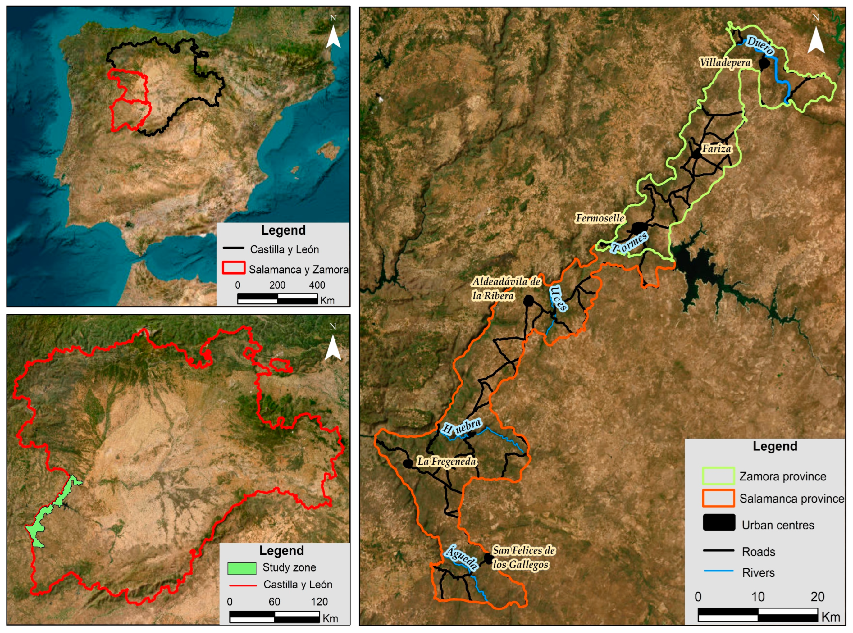
Figure 1. Study area. (Top left): Spain; (bottom left): Castilla y León; (right): study area divided into the provinces of Zamora and Salamanca.
Land 12 00995 g001
Figure 2. Geological map.
Land 12 00995 g002
Figure 3. Slope map.
Land 12 00995 g003
Figure 4. Methodological scheme.
Land 12 00995 g004
Figure 5. Geomechanical stations sheets.
Land 12 00995 g005
Figure 6. (A): Application of Schmidt’s hammer; (B): particle-size distribution of soil samples; (C): soil texture classes (USDA).
Land 12 00995 g006
Figure 7. Lithological cartography.
Land 12 00995 g007
Figure 8. Cartografía hidrogeológica.
Land 12 00995 g008
Figure 9. Geomorphological cartography.
Land 12 00995 g009
Figure 10. Geotechnical synthetic cartography (lithology + hydrogeology + geomorphology).
Land 12 00995 g010
Figure 11. Actual erosion map.
Land 12 00995 g011
Figure 12. Hazard cartography.
Land 12 00995 g012
Figure 13. (A) Blockfield and lehm de Trabanca; (B) Sierro de Peñahorcada with quartz dyke; (C) abandoned meander at Presa de Saucelle; (D) rotational landslide at Pereña; (E) landslides.
Land 12 00995 g013
Disclaimer/Publisher’s Note: The statements, opinions and data contained in all publications are solely those of the individual author(s) and contributor(s) and not of MDPI and/or the editor(s). MDPI and/or the editor(s) disclaim responsibility for any injury to people or property resulting from any ideas, methods, instructions or products referred to in the content.