
Geodiversity and Geoheritage to Promote Geotourism Using Augmented Reality and 3D Virtual Flights in the Arosa Estuary (NW Spain)

 ,
, 
 ,
,
Abstract
1. Introduction
2. Materials and Methods
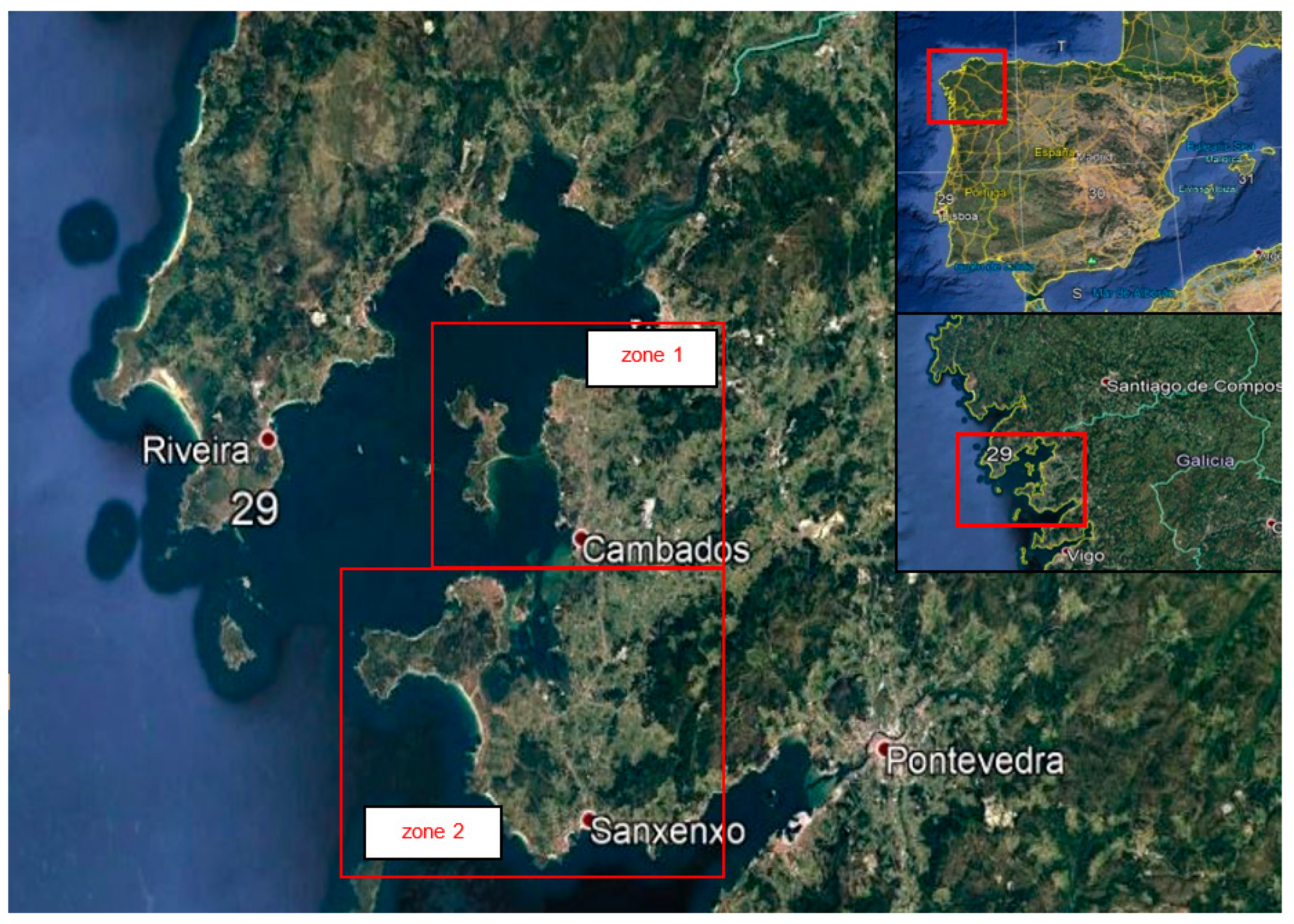
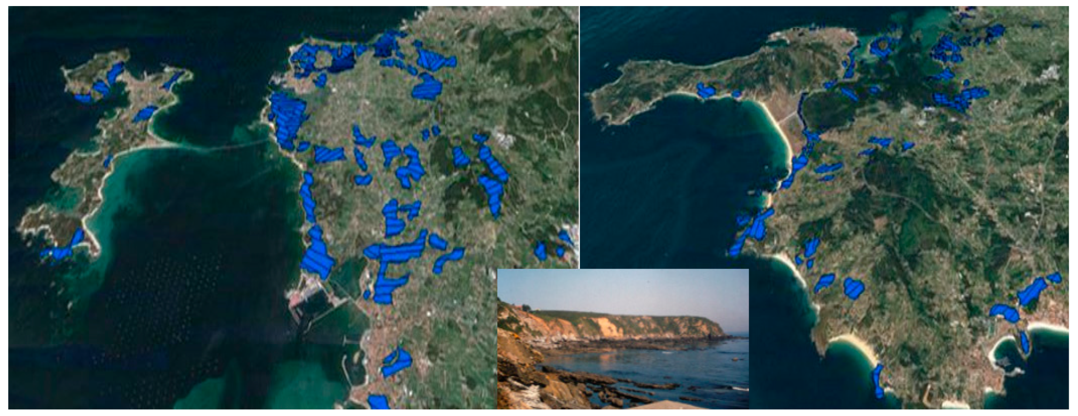
2.1. Study Area
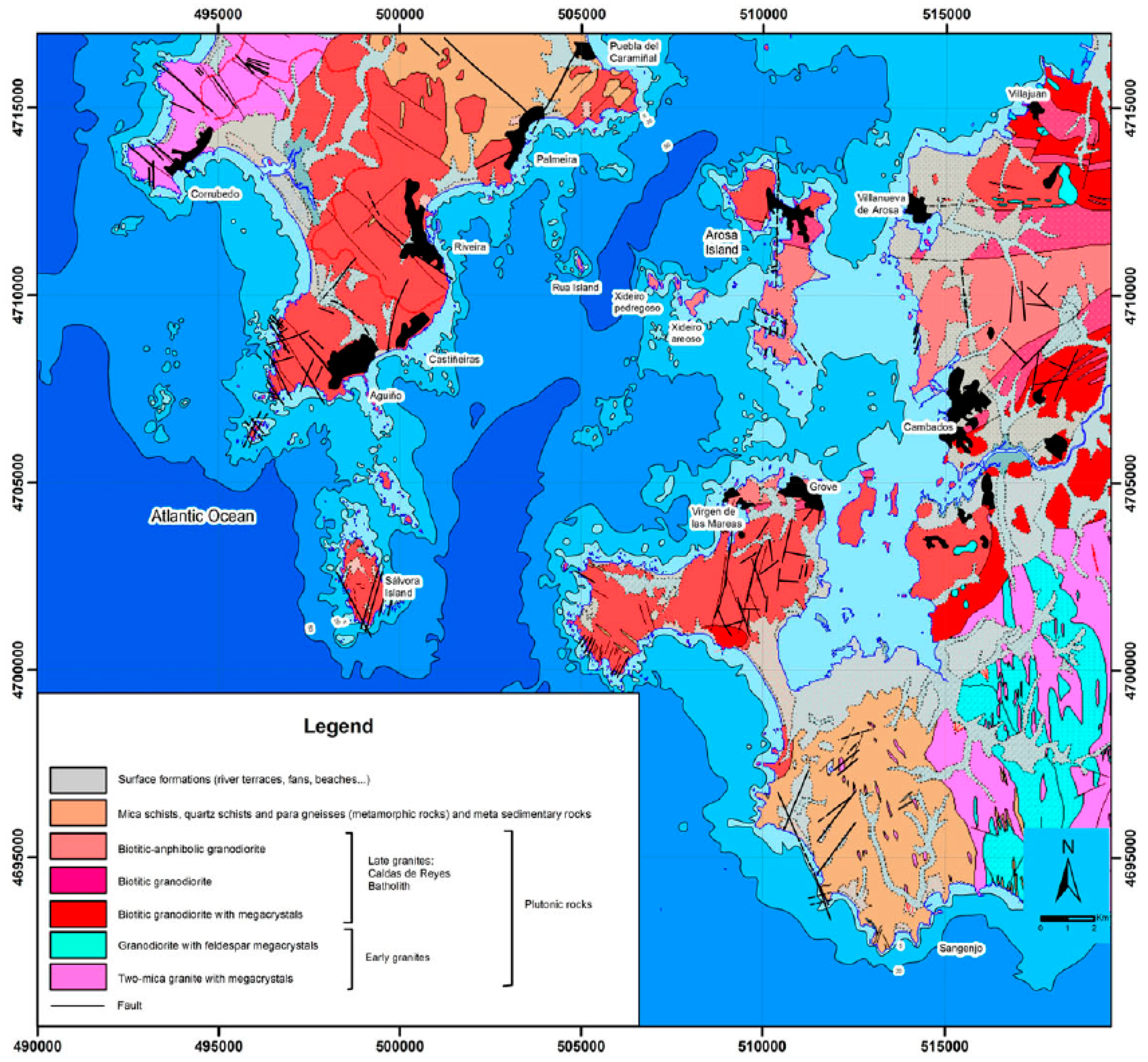
2.2. Geological Context
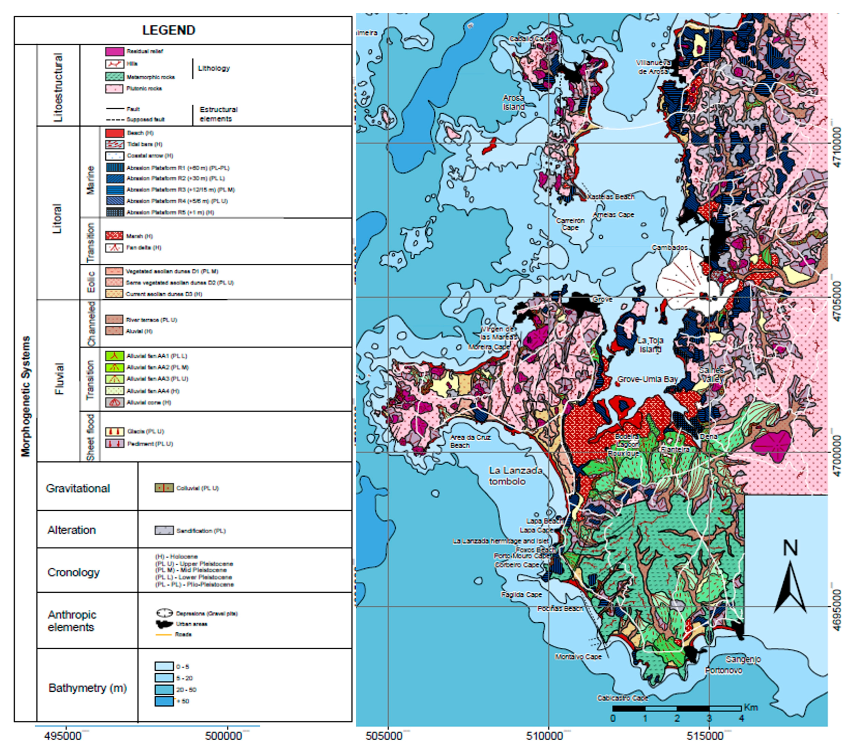
2.3. Geomorphological Context
2.4. Methods
2.4.1. Geosite Evaluation
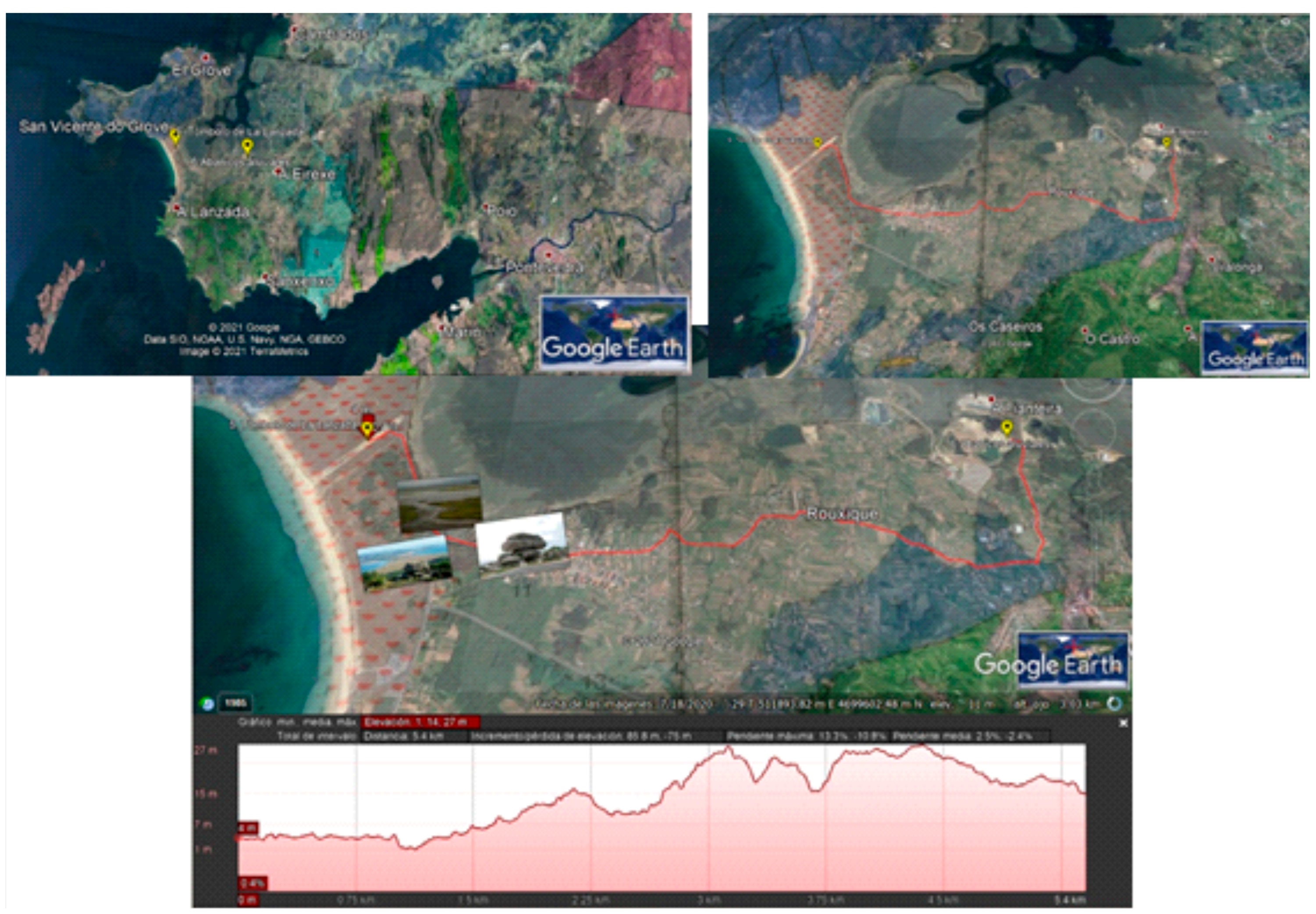
2.4.2. Three-Dimensional Virtual Itinerary
3. Results and Discussion
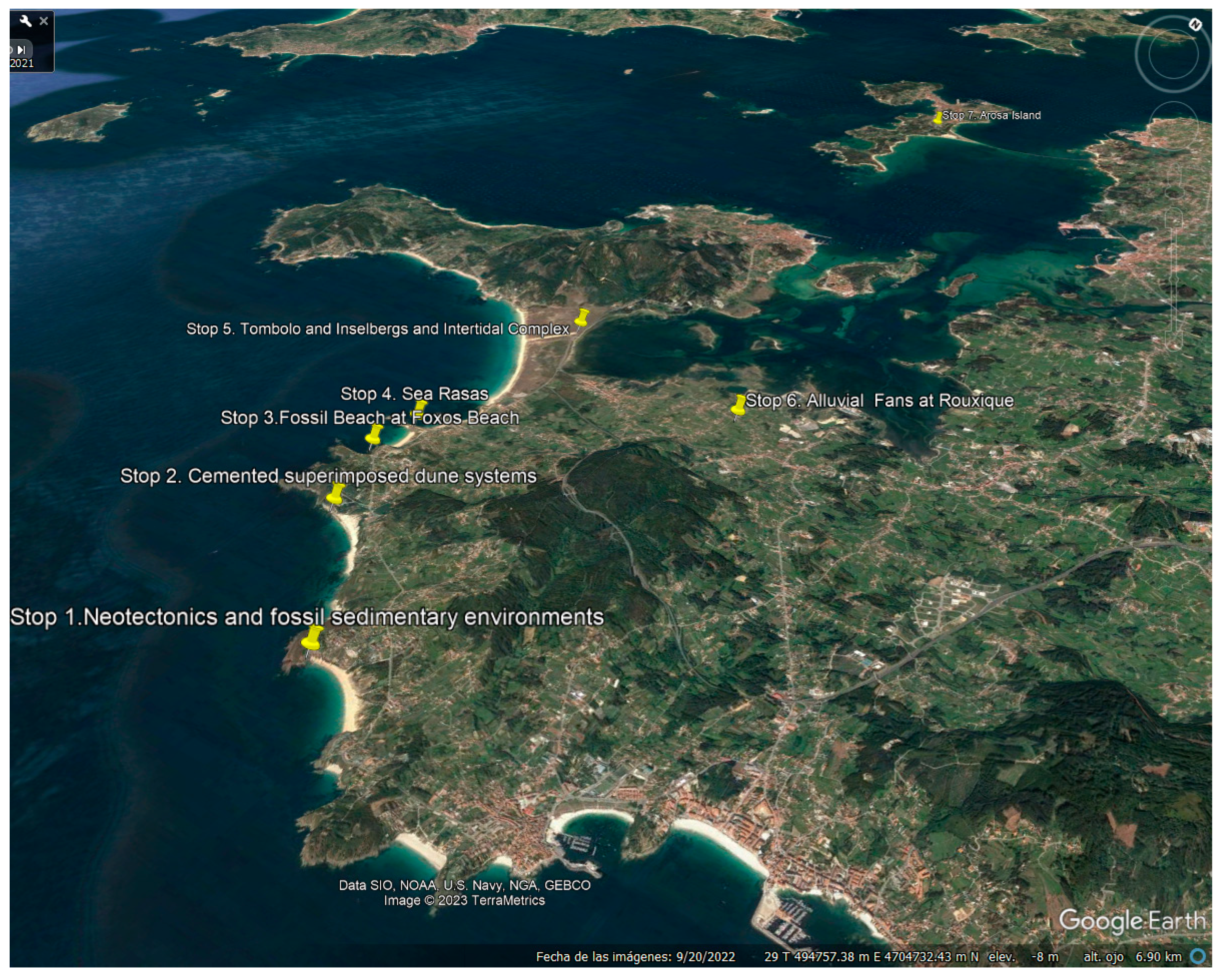
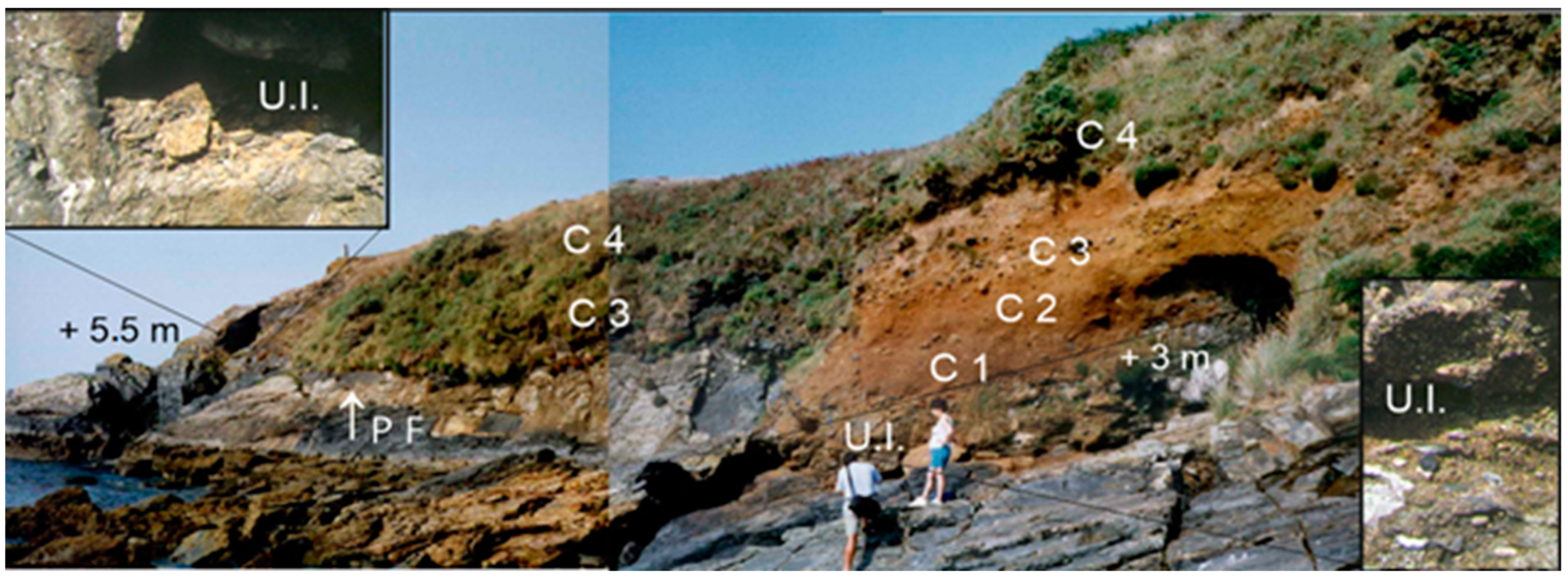
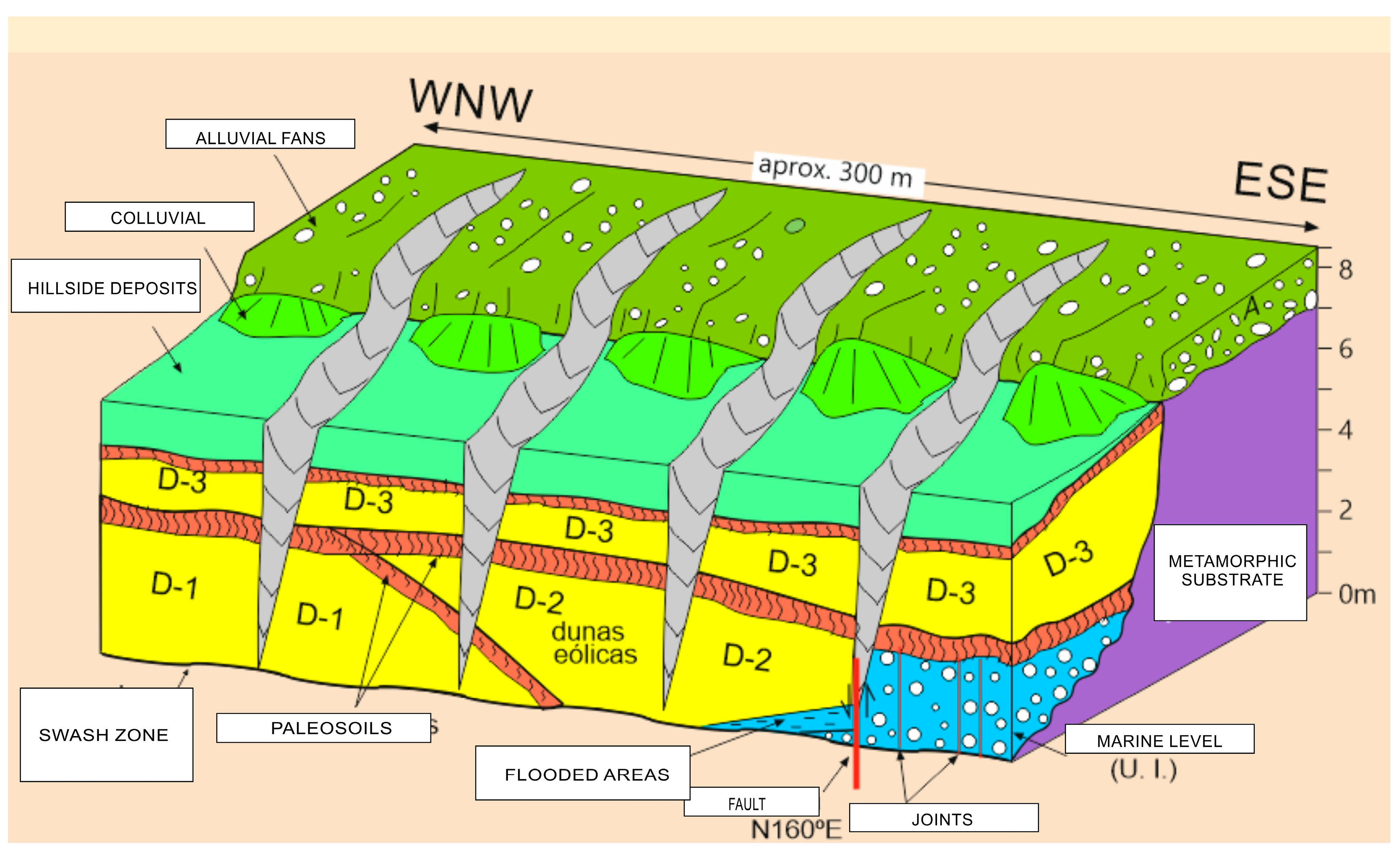
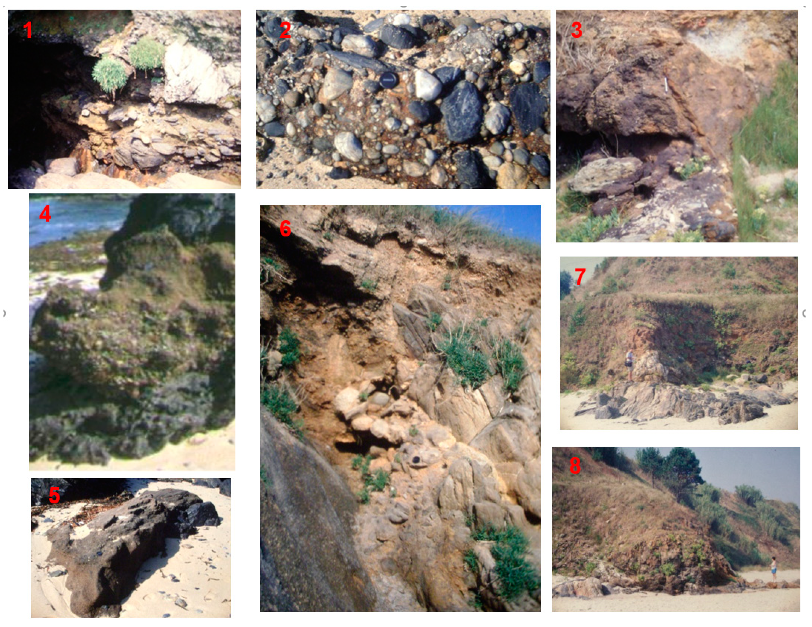
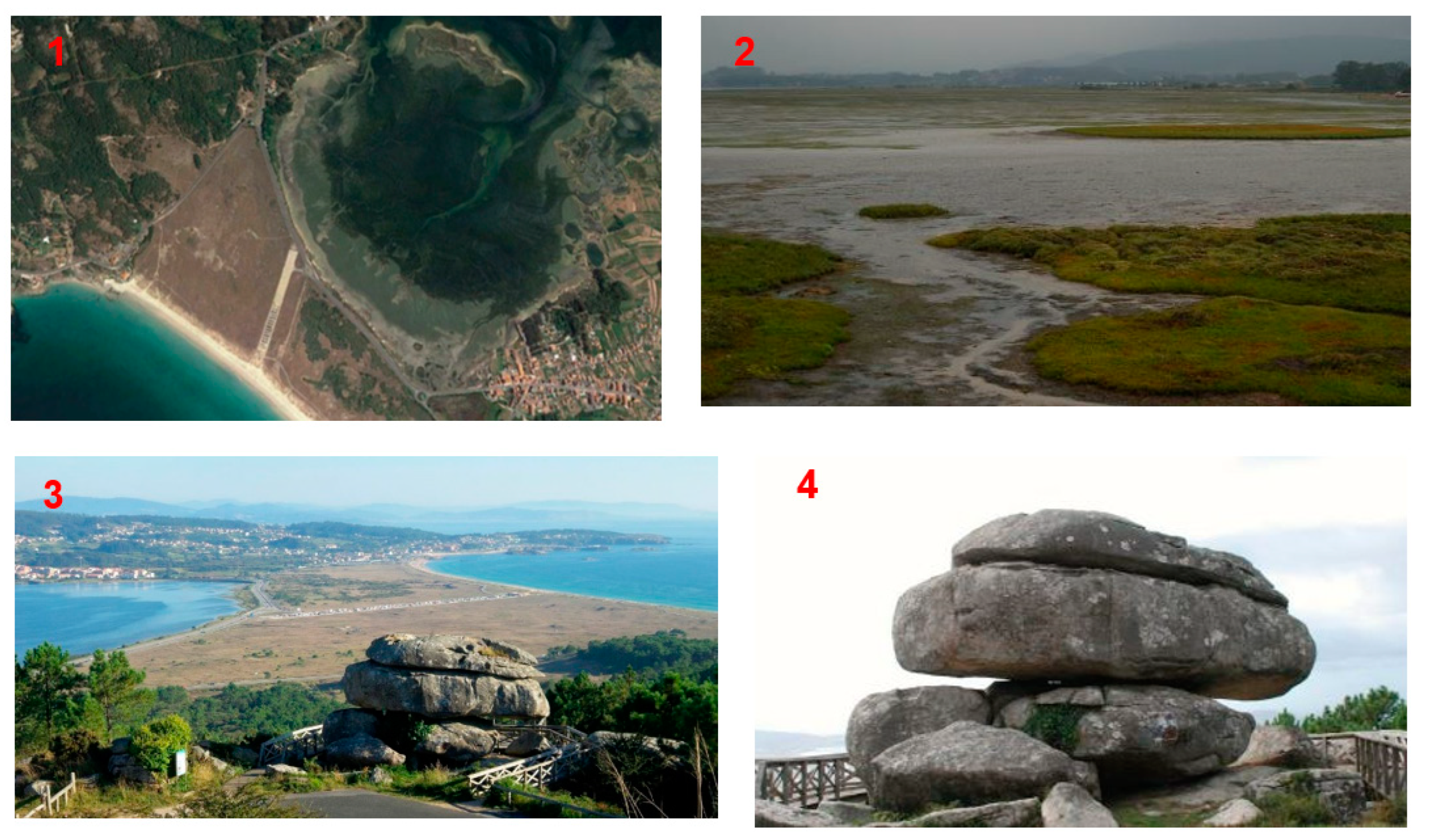
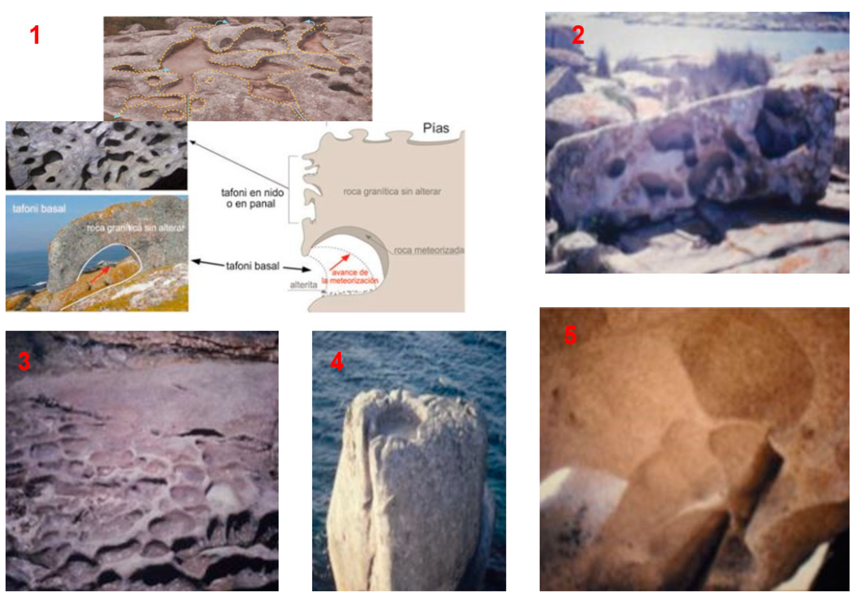
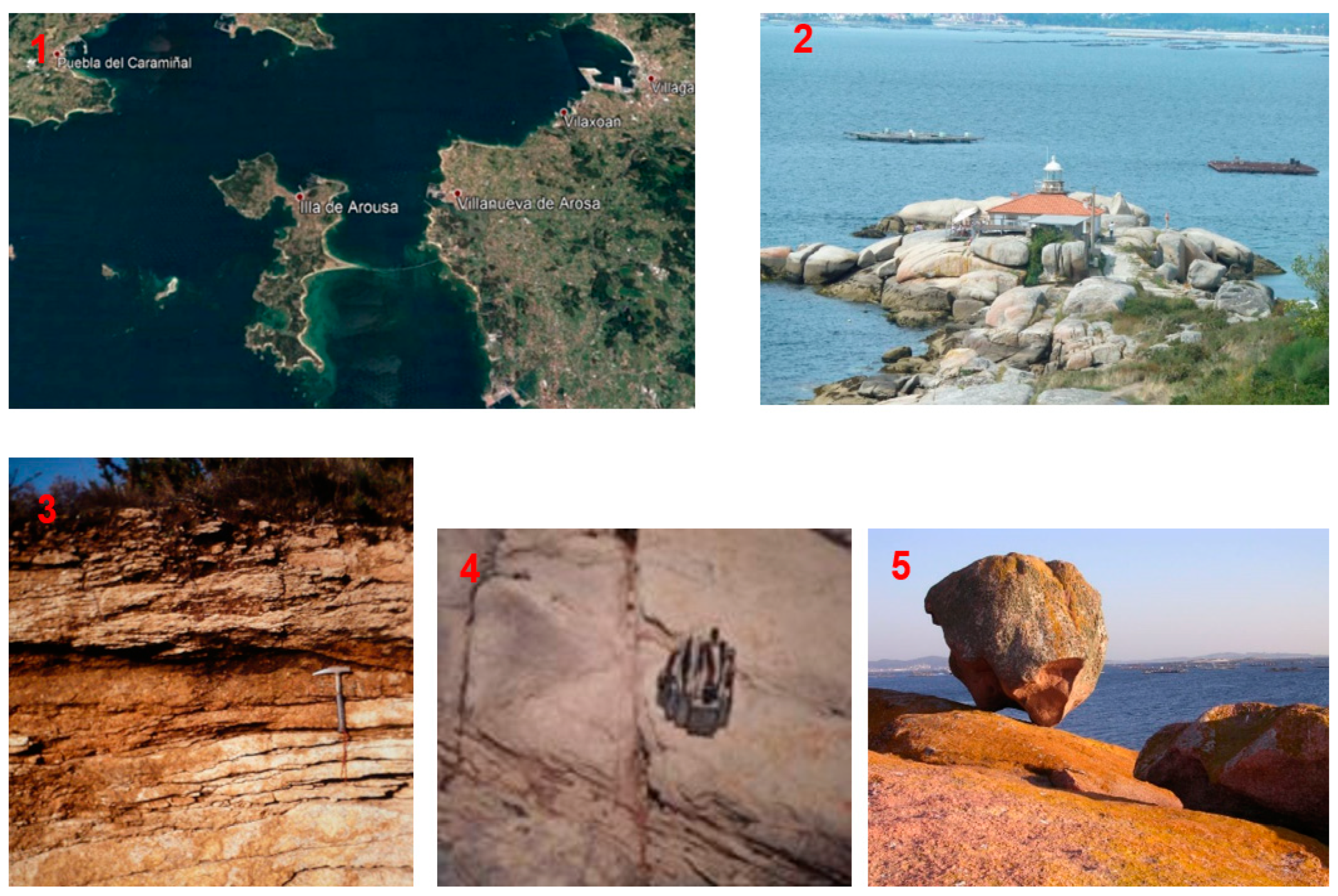
3.1. Geosites Description
3.2. Geoheritage Evaluation
3.3. Three-Dimensional Virtual Itinerary
4. Conclusions
Author Contributions
Funding
Data Availability Statement
Acknowledgments
Conflicts of Interest
References
- Díaz-Martínez, E.; Salazar, Á.; Cortés, Á.G. El patrimonio geológico en España. Enseñanza Cienc. Tierra 2014, 22, 25. [Google Scholar]
- Méndez, G.; Rey, D. Perspectiva histórica del conocimiento geológico de las rías gallegas. J. Iber. Geol. 2000, 26, 21–44. [Google Scholar]
- Nonn, H. Los sedimentos antiguos de la Arosa estuary. Algunas conclusiones geomorfológicas. Notas Comun. Inst. Geológico Min. España 1964, 74, 143–155. [Google Scholar]
- Sole Sabaris, L.; De teran, M.; Otros. Geografía Regional de España. Tomo II; Editorial Ariel S.A.: Madrid, Spain, 1983; pp. 31–58. [Google Scholar]
- Martín Serrano, A. El relieve del Macizo Hespérico: Génesis y cronología de los principales elementos morfológicos. Cuad. Lab. Xeolóxico Laxe 1994, 19, 37–56. [Google Scholar]
- Martínez-Graña, A. Formación y Dinámica de las Rías Gallegas; de Pesca, C., Ed.; Xunta de Galicia: Madrid, Spain, 1994; pp. 1–36. [Google Scholar]
- García-Cortés, Á.; Carcavilla, L.; Vegas, J.; Díaz-Martínez, E. Documento Metodológico para la Elaboración del Inventario Español de Lugares de Interés Geológico; Instituto Geológico y Minero de España, IGME: Madrid, España, 2018; Available online: http://www.igme.es/patrimonio/descargas/METODOLOGIA%20IELIG%20V16%20actualizaci%C3%B3n%202018.pdf (accessed on 15 April 2023).
- Carcavilla Urqauí, L.; López Martínez, J.; Durán Valsero, J.J. Patrimonio Geológico y Geodiversidad: Investigación, Conservación, Gestión y Relación con los Espacios Naturales Protegidos; Instituto Geológico y Minero de España (IGME), Ministerio de Educación y Ciencia, Cuadernos Museo Geominero: Madrid, Spain, 2007; Volume 7, p. 360. [Google Scholar]
- Carcavilla, L.; Durán, J.J.; y López-Martínez, J. Geodiversidad: Concepto y relación con el patrimonio geológico. Geo-Temas 2008, 10, 1299–1303. [Google Scholar]
- Pescatore, E.; Bentivenga, M.; Giano, S.I. Geoheritage and Geoconservation: Some Remarks and Considerations. Sustainability 2023, 15, 5823. [Google Scholar] [CrossRef]
- Zakharovskyi, V.; Németh, K. Quantitative qualitative method for quick assessment of geodiversity. Land 2021, 10, 946. [Google Scholar] [CrossRef]
- Brilha, J. Inventory and quantitative assessment of geosites and geodiversity sites: A review. Geoheritage 2016, 8, 119–134. [Google Scholar] [CrossRef]
- Fepuleai, A.; Weber, E.; Németh, K.; Muliaina, T.; Lese, V. Eruption styles of Samoan volcanoes represented in tattooing, language and cultural activities of the indigenous people. Geoheritage 2017, 9, 395–411. [Google Scholar] [CrossRef]
- Zakharovskyi, V.; Németh, K. Comparison of different scales of qualitative-quantitative as-sessment of geodiversity. Geographies 2022, 12, 45–55. [Google Scholar]
- Pedraza Gilsanz, J.D. Geomorfología: Principios, Métodos y Aplicaciones; Rueda: Madrid, Spain, 1996. [Google Scholar]
- Sanjaume, E.; Gracia, F.J. Las Dunas en España; España: Cadiz, Spain, 2011. [Google Scholar]
- Sánchez-Ferris, E.J.; Fierro-Bandera, I.; Aberasturi-Rodríguez, A.; Navarro-Pedreño, J.; Montoya-Belló, P. La valoración del patrimonio geológico y paleontológico como herramienta de gestión: El Modelo FOPALI. Span. J. Palaeontol. 2019, 34, 35–56. [Google Scholar] [CrossRef]
- Martínez-Graña, A.M.; Goy, J.L.; González-Delgado, J.Á.; Cruz, R.; Sanz, J.; Cimarra, C.; De Bustamante, I. 3D virtual itinerary in the geoheritage from natural areas in Salamanca-Ávila-Cáceres, Spain. Sustainability 2019, 11, 144. [Google Scholar] [CrossRef]
- Hincapie, M.; Cifuentes, L.M.; Valencia-Arias, A.; Quiroz-Fabra, J. Geoheritage and immersive technologies: Bibliometric analysis and literature review. Episodes 2022, 46, 022016. [Google Scholar] [CrossRef]
- Garofano, M. Geowatching, a term for the popularisation of geological heritage. Geoheritage 2015, 7, 25–32. [Google Scholar] [CrossRef]
- Newsome, D.; Dowling, R. Geoheritage and geotourism. In Geoheritage: Assessment, Protection, and Management; Elsevier Inc.: Amsterdam, The Netherlands, 2018; pp. 305–321. [Google Scholar] [CrossRef]
- Pica, A.; Reynard, E.; Grangier, L.; Kaiser, C.; Ghiraldi, L.; Perotti, L.; Del Monte, M. GeoGuides, Urban Geotourism Offer Powered by Mobile Application Technology. Geoheritage 2018, 10, 311–326. [Google Scholar] [CrossRef]
- Graña, A.M.M.; Goy, J.L.; Zazo, C. Cartografia geomorfologica y patrimonio geologico Cuaternario en la Arosa estuary (Pontevedra-La Coruña, Galicia, España). Contrib. Estud. Periodo Cuatern. 2007, 229–230. [Google Scholar]
- Gül, M.; Küçükuysal, C. Geotourism activities via marine excursion: Muğla, SW Türkiye. Geoheritage 2023, 15, 64. [Google Scholar] [CrossRef]
- Stanley, K.B.; Resler, L.M.; Carstensen, L.W. A Public Participation GIS for Geodiversity and Geosystem Services Mapping in a Mountain Environment: A Case from Grayson County, Virginia, U.S.A. Land 2023, 12, 835. [Google Scholar] [CrossRef]
- Silva, J.P.; Rodrigues, C.; Pereira, D.I. Mapping and Analysis of Geodiversity Indices in the Xingu River Basin, Amazonia, Brazil. Geoheritage 2015, 7, 337–350. [Google Scholar] [CrossRef]
- Bétard, F.; Peulvast, J.-P. Geodiversity Hotspots: Concept, Method and Cartographic Application for Geoconservation Purposes at a Regional Scale. Environ. Manag. 2019, 63, 822–834. [Google Scholar] [CrossRef]
- Vital, H.; Domínguez, J.M.L.; Bastos, A.C.; de Araújo, T.C.M. Geodiversidad y Biodiversidad de la Plataforma Tropical del Nordeste de Brasil. In Tropical Marine Environments of Brazil. La Serie de Libros de Estudios Latinoamericanos; Dominguez, J.M.L., de Kikuchi, R.K.P., Filho, M.C.d.A., Schwamborn, R., Vital, H., Eds.; Springer: Cham, Switzerland, 2023. [Google Scholar] [CrossRef]
- Martinez-Graña, A.M.; Goy, J.L.; Cardeña, C.Z. Natural heritage mapping of the las batuecas-sierra de Francia and Quilamas Nature Parks (SW Salamanca, Spain). J. Maps 2011, 7, 600–613. [Google Scholar] [CrossRef]
- González-Delgado, J.A.; Martínez-Graña, A.; Holgado, M.; Gonzalo, J.C.; Legoinha, P. Augmented Reality as a Tool for Promoting the Tourist Value of the Geological Heritage around Natural Filming Locations: A Case Study in “Sad Hill” (The Good, the Bad and the Ugly Movie, Burgos, Spain). Geoheritage 2020, 12, 34. [Google Scholar] [CrossRef]
- Marino Alfonso, J.L.; Poblete Piedrabuena, M.A.; Beato Bergua, S. Paisajes de Interés Natural (PIN) en los Arribes del Duero (Zamora, España). Investig. Geográficas 2020, 73, 95–119. [Google Scholar] [CrossRef]
- Graña, A.M.M.; Goy, J.L.; Zazo, C. Actividad tectónica en el Noroeste Peninsular, en base a los registros de los depósitos costeros de los últimos 130.000 años (rías Arosa-Pontevedra, Galicia). Geotemas 2000, 1, 263–266. [Google Scholar]


| Parameter | Scientific Interest | Educational Interest | Tourist/Recreational Interest |
|---|---|---|---|
| Representativeness (R) | 30 | 5 | --- |
| Character type locality (T) | 10 | 5 | --- |
| Degree of scientific knowledge of the location (K) | 15 | --- | --- |
| State of conservation (C) | 10 | 5 | --- |
| Viewing conditions (O) | 10 | 5 | 5 |
| Rarity (A) | 15 | 5 | --- |
| Geological diversity (D) | 10 | 10 | --- |
| Learning objectives/educational use (Cdd) | --- | 20 | --- |
| Logistics infrastructure (Il) | --- | 15 | 5 |
| Population density (Dp) | --- | 5 | 5 |
| Accessibility (Ac) | --- | 15 | 10 |
| Intrinsic fragility (E) | --- | --- | 15 |
| Association with elements natural and/or cultural (NH) | --- | 5 | 5 |
| Beauty or spectacularity (B) | --- | 5 | 20 |
| Informative content/use (Cdv) | --- | --- | 15 |
| Potential for tourism/recreation activities (Ptr) | --- | --- | 5 |
| Proximity to recreational areas (Zr) | --- | --- | 5 |
| Socioeconomic environment (Es) | --- | --- | 10 |
| TOTAL | 100 | 100 | 100 |
| S1 | S2 | S3 | S4 | S5 | S6 | S7 | |
|---|---|---|---|---|---|---|---|
| Representativeness | 2 | 2 | 2 | 2 | 2 | 2 | 2 |
| Character type locality | 1 | 1 | 1 | 1 | 1 | 1 | 1 |
| Degree of scientific knowledge about the place | 4 | 4 | 2 | 2 | 2 | 2 | 2 |
| State of conservation | 2 | 2 | 2 | 2 | 2 | 2 | 4 |
| Viewing conditions | 4 | 4 | 4 | 4 | 4 | 2 | 4 |
| Rarity | 0 | 0 | 2 | 2 | 0 | 0 | 2 |
| Geological diversity | 4 | 4 | 2 | 0 | 0 | 2 | 4 |
| Learning objectives/educational use | 2 | 2 | 2 | 2 | 2 | 2 | 2 |
| Logistics infrastructure | 4 | 4 | 4 | 4 | 4 | 4 | 4 |
| Population density | 2 | 2 | 2 | 2 | 2 | 2 | 2 |
| Accessibility | 1 | 0 | 0 | 4 | 4 | 2 | 2 |
| Intrinsic fragility | 1 | 1 | 0 | 1 | 4 | 4 | 1 |
| Association with elements of nature/culture heritage | 4 | 4 | 4 | 4 | 4 | 4 | 4 |
| Beauty or spectacularity | 1 | 1 | 1 | 0 | 1 | 1 | 1 |
| Informative content/use | 2 | 2 | 2 | 2 | 2 | 2 | 2 |
| Potential for activities tourism/recreation | 1 | 2 | 2 | 2 | 2 | 1 | 1 |
| Proximity to recreational areas | 4 | 4 | 4 | 4 | 4 | 4 | 4 |
| Socioeconomic environment | 1 | 1 | 1 | 1 | 1 | 1 | 1 |
| Total | 36 | 37 | 37 | 39 | 41 | 38 | 43 |
| S1 | S2 | S3 | S4 | S5 | S6 | S7 | |
|---|---|---|---|---|---|---|---|
| Scientific interest (Vc) | 230 | 230 | 210 | 160 | 160 | 160 | 200 |
| Educational interest (Vd) | 235 | 225 | 210 | 220 | 240 | 230 | 245 |
| Tourist/recreational interest (Vt) | 180 | 175 | 160 | 195 | 260 | 225 | 190 |
| Total | 565 | 630 | 580 | 575 | 660 | 615 | 635 |
| Vc = value out 10 | 5.8 | 5.8 | 5.3 | 4.0 | 4.0 | 4.0 | 5.0 |
| Vd = value out 10 | 5.9 | 5.6 | 5.3 | 5.5 | 6.0 | 5.8 | 6.1 |
| Vt = value out 10 | 4.5 | 4.4 | 4.0 | 4.9 | 6.5 | 5.6 | 4.8 |
| Vc = algorithm | 95 | 95 | 90 | 74 | 74 | 74 | 84 |
| Vd = algorithm | 66 | 63 | 59 | 63 | 65 | 64 | 68 |
| Vt = algorithm | 44 | 42 | 36 | 42 | 69 | 62 | 46 |
| S1 | S2 | S3 | S4 | S5 | S6 | S7 | |
|---|---|---|---|---|---|---|---|
| Geosite size factor (EF) | 0.015 | 0.008 | 0.015 | 0.008 | 0.003 | 0.003 | 0.003 |
| Fragility (F) | 5 | 20 | 10 | 5 | 20 | 10 | 5 |
| Natural threats (AN) | 10 | 20 | 10 | 20 | 20 | 1 | 10 |
| Degradation susceptibility (SDN) | 0.75 | 3.00 | 1.5 | 0.75 | 1.00 | 0.03 | 0.13 |
| Interest for mining or water exploitation (VuM) | 0 | 0 | 0 | 0 | 2 | 0 | 4 |
| Vulnerability to plunder (VuEX) | 0 | 1 | 0 | 0 | 0 | 0 | 0 |
| Proximity to activities and infrastructures (VuI) | 1 | 1 | 1 | 1 | 1 | 2 | 4 |
| Accessibility (Ac) | 1 | 0 | 1 | 1 | 4 | 1 | 4 |
| Protection regime(P) | 4 | 4 | 4 | 4 | 1 | 4 | 4 |
| Physical or indirect protection (PF) | 4 | 4 | 4 | 4 | 4 | 4 | 4 |
| Land ownership and access regime (TS) | 4 | 4 | 4 | 4 | 4 | 4 | 4 |
| Population density (DP) | 2 | 2 | 2 | 2 | 2 | 2 | 2 |
| Proximity to recreational areas (ZR) | 4 | 4 | 4 | 4 | 4 | 4 | 4 |
| Anthropic degradation susceptibility (SDA) | 1.73 | 0.98 | 1.73 | 0.86 | 0.45 | 0.33 | 0.73 |
| Degradation Risk (RDNC) | 0.435 | 1.74 | 0.795 | 0.3 | 0.4 | 0.01 | 0.06 |
| Degradation Risk (RDND) | 0.4425 | 1.68 | 0.795 | 0.412 | 0.6 | 0.0145 | 0.076 |
| Degradation Risk (RDNT) | 0.337 | 1.32 | 0.6 | 0.367 | 0.65 | 0.014 | 0.06 |
| Degradation Risk (RDAC) | 1.000 | 0.5655 | 0.914 | 0.345 | 0.18 | 0.13 | 0.348 |
| Degradation Risk (RDAD) | 1.017 | 0.546 | 0.914 | 0.474 | 0.27 | 0.188 | 0.442 |
| Degradation Risk (RDAT) | 0.776 | 0.429 | 0.69 | 0.422 | 0.2925 | 0.182 | 0.348 |
Disclaimer/Publisher’s Note: The statements, opinions and data contained in all publications are solely those of the individual author(s) and contributor(s) and not of MDPI and/or the editor(s). MDPI and/or the editor(s) disclaim responsibility for any injury to people or property resulting from any ideas, methods, instructions or products referred to in the content. |
© 2023 by the authors. Licensee MDPI, Basel, Switzerland. This article is an open access article distributed under the terms and conditions of the Creative Commons Attribution (CC BY) license (https://creativecommons.org/licenses/by/4.0/).
Share and Cite
Martínez-Graña, A.; González-Delgado, J.A.; Nieto, C.; Villalba, V.; Cabero, T. Geodiversity and Geoheritage to Promote Geotourism Using Augmented Reality and 3D Virtual Flights in the Arosa Estuary (NW Spain). Land 2023, 12, 1068. https://doi.org/10.3390/land12051068
Martínez-Graña A, González-Delgado JA, Nieto C, Villalba V, Cabero T. Geodiversity and Geoheritage to Promote Geotourism Using Augmented Reality and 3D Virtual Flights in the Arosa Estuary (NW Spain). Land. 2023; 12(5):1068. https://doi.org/10.3390/land12051068
Chicago/Turabian StyleMartínez-Graña, Antonio, José Angel González-Delgado, Carlos Nieto, Vanessa Villalba, and Teresa Cabero. 2023. "Geodiversity and Geoheritage to Promote Geotourism Using Augmented Reality and 3D Virtual Flights in the Arosa Estuary (NW Spain)" Land 12, no. 5: 1068. https://doi.org/10.3390/land12051068
APA StyleMartínez-Graña, A., González-Delgado, J. A., Nieto, C., Villalba, V., & Cabero, T. (2023). Geodiversity and Geoheritage to Promote Geotourism Using Augmented Reality and 3D Virtual Flights in the Arosa Estuary (NW Spain). Land, 12(5), 1068. https://doi.org/10.3390/land12051068