Article

Using a Geotrail for Teaching Geography: An Example of the Virtual Educational Trail “The Story of Liberec Granite”

Department of Geography, Faculty of Science, Humanities and Education, Technical University of Liberec, Komenského 2, 46005 Liberec, Czech Republic
Land 2023, 12(4), 828; https://doi.org/10.3390/land12040828
Submission received: 25 February 2023 / Revised: 25 March 2023 / Accepted: 31 March 2023 / Published: 4 April 2023

Abstract

:
Geotrails are valuable resources for the field teaching of geography and natural history, as they amusingly explain the phenomena associated with inanimate nature and geoheritage. However, not all geotrails are frequently used for field education, in fact, most of them are only used sporadically. In order to identify the key elements needed for a geotrail to be used frequently and successfully for field education, an evaluation of the virtual nature trail “The Story of Liberec Granite”, which is one of the most used trails for educational purposes in the Czech Republic, was carried out. The evaluation was conducted using a questionnaire survey and structured interviews with teachers and other educational staff who have used the geotrail at least three times in their teaching. The results of the evaluation showed that the proximity of the geotrail to the school building is very important, that all geotrail materials must be developed with the target group in mind, i.e., school-age children, and that they must be professionally designed to appeal to the pupils. The geotrail should be accompanied by materials that can be used in field education (such as worksheets), containing tasks for pupils so that they do not remain only the passive recipients of information but become active participants in discerning information. Teachers will also appreciate it if there are methodological materials accompanying the geotrail that explain how to design the fieldwork.

1. Introduction

With the development of geotourism in the world, more and more geotrails are being built. Geotrails are thematic educational trails that serve to popularise knowledge in the field of natural sciences, especially geology, geography and biology [1,2,3]. They seek to convey knowledge about the objects of inanimate nature that visitors may see on their journey in an entertaining and popular way. They are therefore most often built in geoparks, national parks and other nature reserves. However, there are geotrails that focus on linking natural and cultural heritage and pass through towns or built-up areas [4,5,6].
In addition to being used for geotourism, geotrails can also be used for education [1,7]. For this purpose, it is advisable for a group of pupils or students to be led by a guide who explains the contents of the geotrail message to them personally. The guide must be able to engage the target group of children or adolescents, be an expert on the subject, be able to explain the phenomena in a simple and understandable way, use activating teaching methods (so that some less motivated pupils do not start to disturb the programme), use different objects in the surroundings (so that the pupils use their different senses to explore, and have the opportunity to ‘feel’ the object) and generally follow the principles of good interpretation [8,9,10]. The overall concept of a guided visit to the geotrail is that of a comprehensive educational programme with clearly defined objectives, a programme adapted to the target group in accordance with the client’s specifications. However, guided tours of geotrails are not common in all places. Generally, most of them are organised in geoparks [11,12], some in national parks and other nature reserves and relatively few are organised outside these regions [13,14].
Most often, the teacher is faced with the question of how to use the geotrail in his teaching. If it were a classical nature trail, with boards placed at the various points of interest, then teachers usually combine their own interpretation with tasks that use the text on the boards, which can be rather monotonous. Teachers are also limited by the extent of their knowledge, which is usually not at the level of a trained professional. It is therefore worth considering how to design geotrails in a way that teachers in all schools can use them in a more exciting and effective way that stimulates pupils’ and students’ interest in the subject [15,16,17,18].
This article presents the experience gained during the creation and subsequent evaluation of the usability of the urban geotrail called “The Story of Liberec Granite” [19], for educational purposes. The geotrail was created in 2020 as one of the outputs of the project “Geodiversity within the city: perception, function, potential”, where the aim was to test to what extent the theme of inanimate nature in the city is able to attract tourists. Due to the limited possibilities of placing educational signs in the area of the listed buildings, it was decided that the geotrail would take the form of a virtual educational trail, i.e., its content would be available on a website, the existence of which the visitor would learn at the place of its start (the North Bohemian Museum in Liberec) or at the local tourist information centre. The content of the geotrail was supplemented with educational materials (worksheets), as we expected it to be an interesting field learning opportunity in geography and natural history for local schools. The information about the existence of the virtual nature trail was subsequently disseminated to teachers in all schools and educators in non-profit organisations in the region, and after (less than) three years since the creation of the geotrail, a qualitative evaluation of its actual usability in teaching was carried out.

2. Theoretical Background

Geotrails are a form of geotourism module that can be found both inside and outside of geoparks [1]. It is a guided or self-guided trail of multiple (geo)sites that interprets geology and landscapes. A geotrail is made up of multiple sites that have landscapes and heritage significance that would be of interest to tourists and thus add to the visitor experience [20]. Geotrail is therefore one form of educational trails that focuses on inanimate nature and its links to the living nature and the cultural environment.
Geotrails are one of the products of geotourism, a type of tourism focused on the beauty of inanimate nature [21,22,23,24,25]. Geotourism is defined as “a form of natural area tourism that specifically focuses on geology and landscape. It promotes tourism to geosites and the conservation of geo-diversity and an understanding of Earth Sciences through appreciation and learning. This is achieved through independent visits to geological features, use of geo-trails and viewpoints, guided tours, geo-activities and patronage of geosite visitor centers” [25].
The targets of geotourism are places, known as geosites, which are part of the so-called geoheritage. “Geoheritage encompasses global, national, statewide, and local features of geology, at all scales that are intrinsically important sites or culturally important sites offering information or insights into the evolution of the Earth; or into the history of science, or that can be used for research, teaching, or reference” [26]. A geosite is then “a single location that offers tourism experiences through geology and landscape interpretation” [20].
Geotrails are not only a destination for geotourism, but can also be used for educational purposes. In this case, we are talking about geoeducation, which is understood as the teaching of geo-scientific facts [1]. Geoeducation is considered “a part of environmental education and education for sustainable development, which creates holistic access to geoscientific knowledge, geotourism opportunities, but also to geosite protection and regional awareness” [1,27].
An important part of geoeducation is the interpretation of facts, contexts and the surrounding environment, referred to as geointerpretation. Geointerpretation is not just about explaining facts, but is the whole art of communicating something essential about our natural or cultural heritage in such a way that the visitor, reader or listener accepts it, thinks about it and starts acting [28]. Geointerpretation is all the more complicated because geological phenomena include scales with which the human mind has no experience, therefore it is very difficult to imagine such situations (millions and billions of years, enormous pressures, temperatures, masses of rock, etc.) [29,30]. However, geointerpretation is an essential part of geoeducation, and therefore it is very important that the teacher or educator is also a good interpreter.
Although geoeducation can take place directly in schools or other educational institutions, it can also be used for fieldwork, which provides added value in that the subject matter can be seen live around you. Fieldwork is highlighted by a number of authors [31,32,33,34,35] as one of the best forms of learning, as it combines elements of experiential education, research and project teaching, and involves working in teams and cooperation in non-traditional activities, etc. However, on the other hand, fieldwork puts increased demands on teachers and is more time-consuming than regular teaching, due to the need to get out into the field [36,37]. Despite this, fieldwork is a key part of geoeducation [38,39].

3. Materials and Methods

The case study described in this article analyses a selected geotrail, the virtual nature trail “The Story of Liberec Granite”, which was co-designed by the author of this article The geotrail uses a part of the territory of the city of Liberec, namely the north-eastern surroundings of the city centre, where there are historical buildings from the 19th and early 20th century, a number of former quarries for Liberec granite and beautiful natural scenery around the Harcov dam. The content of the virtual nature trail can be found at https://geostezka.fp.tul.cz/ (accessed on 30 March 2023) [19]. All texts are unfortunately only in Czech, their translation into English is in Appendix A.
Given the educational focus of the article, it is also worth mentioning the address from where the didactic materials, that form a key part of the educational superstructure of the geotrail, can be downloaded: https://geostezka.fp.tul.cz/images/Didakticke-materialy.pdf (accessed on 30 March 2023) [40]. The file includes an introductory text explaining the use of the worksheets created, which are used afterwards. The worksheets are designed as black and white A4 sheets printed on both sides, and three of them are included in the file: one for primary school level 1 (ages 6–11), one for primary school level 2 (ages 11–15) and one for secondary school (ages 15–19).
Two methods were used to evaluate the usability of the geotrail, namely qualitative content analysis of teachers’ and other educators’ responses to the online questionnaire, and structured interviews with selected teachers and other educators. The online questionnaire was created using Google Forms and contained the following open-ended questions:
  • With which groups did you visit the virtual nature trail “The Story of Liberec Granite”?
  • Did you use didactic materials from the nature trail website in your fieldwork? In what way?
  • Have you used videos, texts and images from the nature trail website in your fieldwork? In what way?
  • Did your field training include the whole route of the nature trail or only a part of it? Why did you choose this option?
  • What was the response of your pupils or students to the virtual nature trail “The Story of Liberec Granite”? What did they like and what did they like less?
  • What do you personally like or dislike about the virtual nature trail “The Story of Liberec Granite”? What could we improve?
  • Is everything clear to you from the texts on the website, or have your pupils or students asked you a question you couldn’t answer?
  • Do you think that a similar virtual nature trail could work in the countryside, or is it more suited to the city?
The online questionnaire was not intended for the general public, but was to be filled out only by teachers and other educators who had walked the virtual nature trail “The Story of Liberec Granite” at least three times with a group of pupils or students aged 6–18. The link to the questionnaire was sent out by email and through social networks. The condition of at least three excursions was already pointed out in this email or social media post, but also was stated at the beginning of the questionnaire. In total, 33 respondents answered the questionnaire, of which 18 were primary school teachers, 7 secondary school teachers and 8 after-school teachers.
The second method used was structured interviews, which were conducted with teachers and other educators who had walked the geotrail at least six times with a group of pupils or students. The recruitment of this group was conducted in the same way as the first method, except that the teachers who met the requirement of six field trips were not asked to complete a questionnaire, but were asked to make an appointment for an interview. The interview was conducted online via Google Meet and the questions were the same as for the online questionnaire. The difference, however, was that the interviewer asked for more details about the respondent’s answers. A total of 8 respondents participated in the structured interviews, namely 4 primary school teachers, 1 secondary school teacher and 3 after-school teachers.
Before the implementation of both the aforementioned methods, a pilot survey using structured interviews was conducted on the experience of using the geotrail in teaching for a sample of 10 teachers. As a part of this pilot testing, it became clear that teachers who had completed the program with students only once or twice often failed to use the full potential of the materials we developed. On the contrary, one of the answers mentioned that “as I did the program for the sixth time, I already had it perfectly learned and prepared”. The results of the pilot survey led us to chose the aforementioned boundaries—three visits and six visits—as the threshold for inclusion in our research.
It should also be mentioned that all respondents had a university degree in the field of geography, biology, or related natural sciences, as this is required by Czech laws for the employment of a teacher. This is not a requirement for out-of-school education, however, organisations operating in out-of-school education usually require it because they want to provide high-level services. The majority of respondents were from Liberec (it is the closest to the trail and have a large number of residents), but almost 40% of respondents were from nearby towns and villages. The respondent from the farthest locality was from the town of Česká Lípa, which was 50 km away.

4. Results

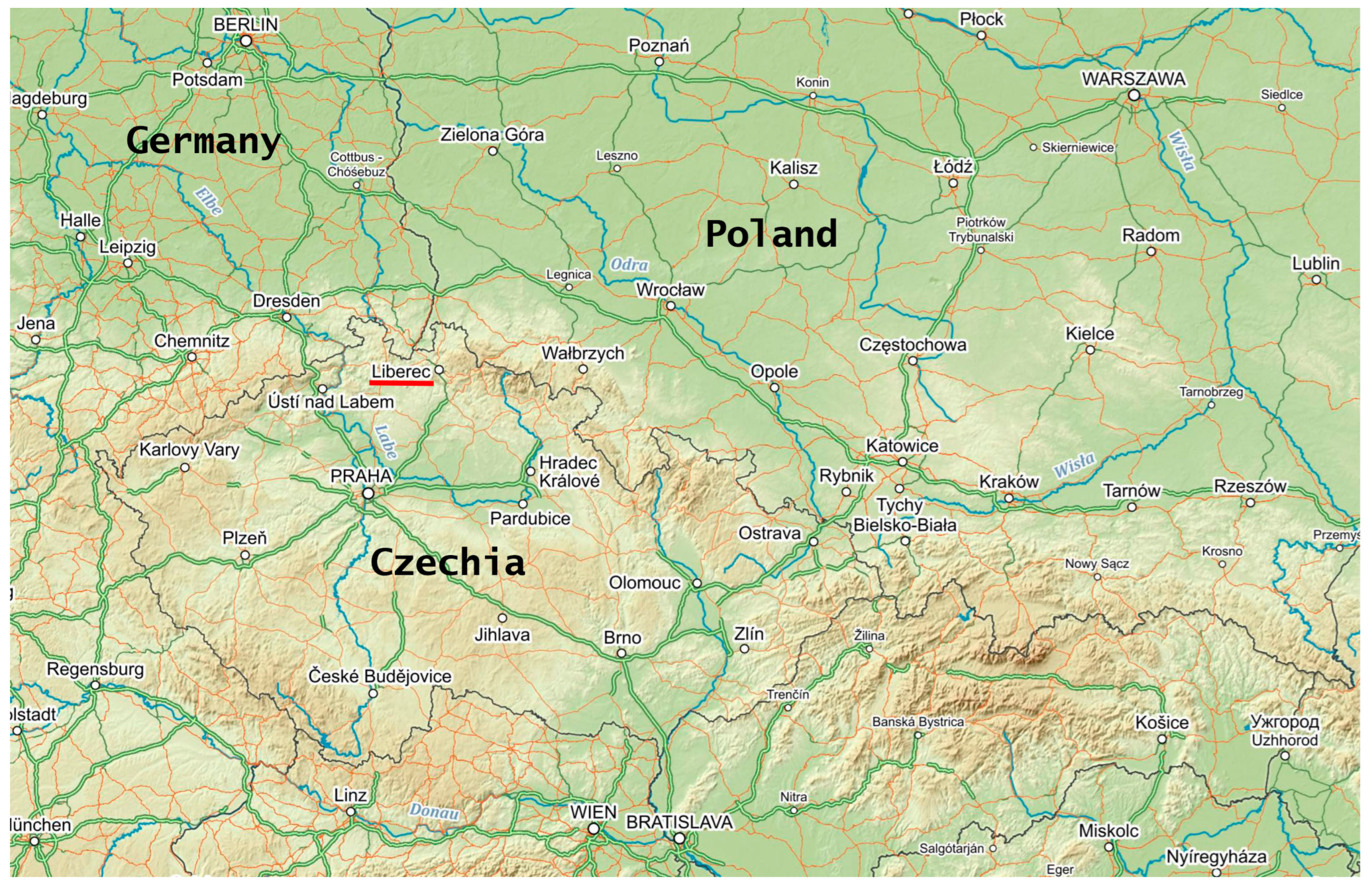
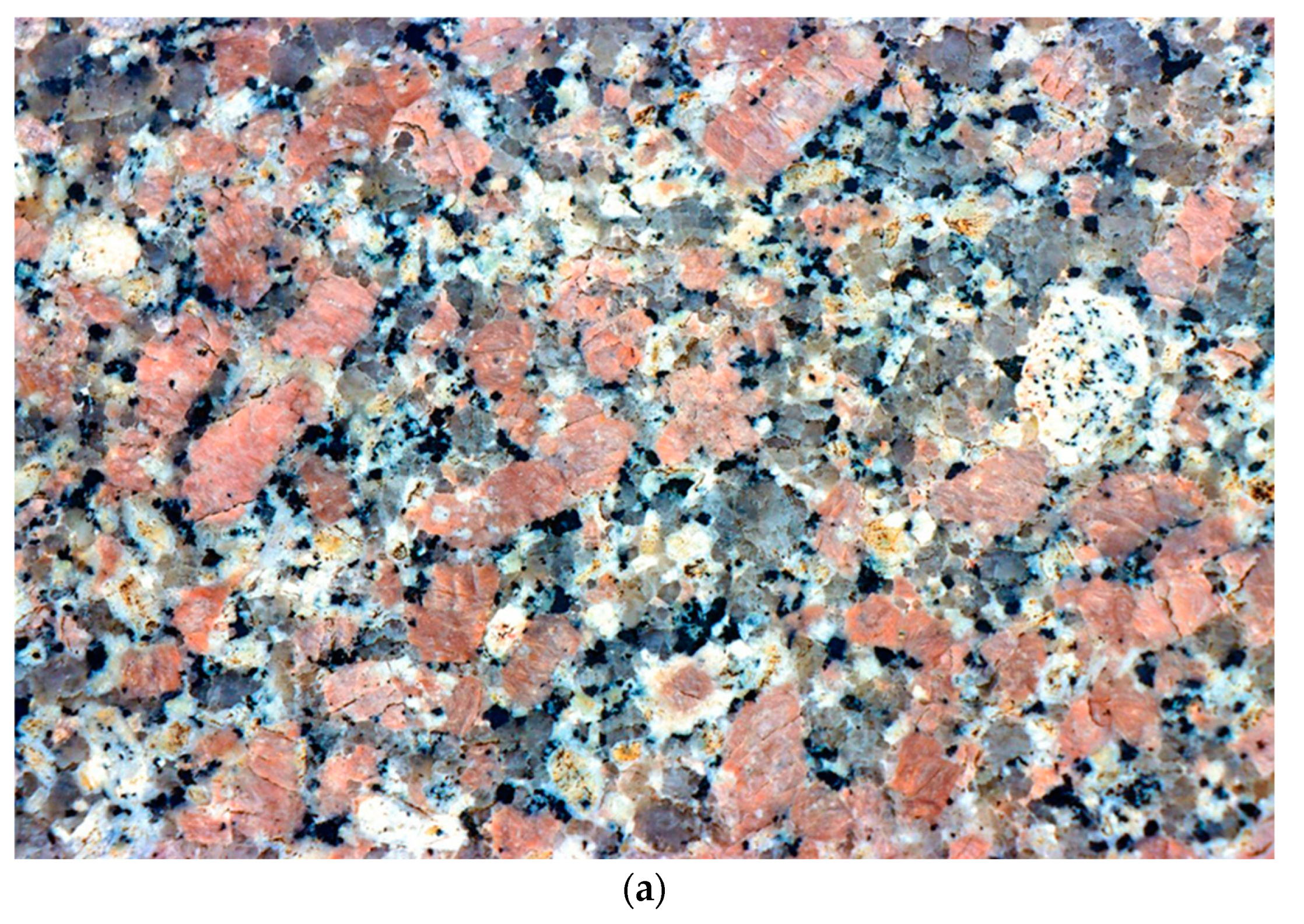
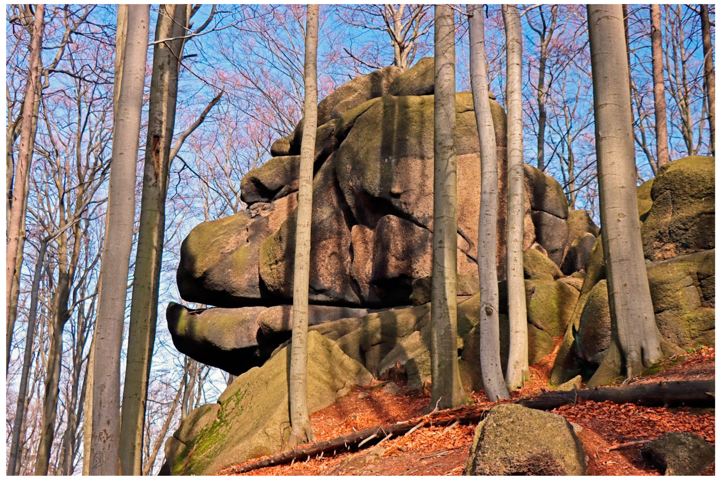
4.1. The Theme of the Geotrail “The Story of Liberec Granite”

The city of Liberec—in whose north-eastern part the geotrail is located—is situated in the northern part of the Czech Republic (see Figure 1). It is the regional capital with a population of about 105,000 inhabitants. Originally a small town, it became the largest and most important town in the area during the Industrial Revolution, known for its engineering and textile industries, as well as for the mining of local granite [41,42]. Liberec granite is the traditional trade name for the coarse-grained igneous rock that makes up most of the bedrock in Liberec. Its characteristic light pink colour (see Figure 2) is mainly due to the pink crystals of potassium feldspar, which occupy up to half of the rock’s volume. Their shape is usually thickly tabular, with sections of the largest growths measuring about 3 × 2 cm. In addition to potassium feldspar, the coarse-grained parent material contains sodic calcareous feldspar, quartz, biotite and amphibole, muscovite and small amounts of zircon, apatite, titanite, orthite, magnetite and pyrite. [43] Its age has been dated at 319.52 Ma [44]. According to the current state of knowledge, it was formed during the slow solidification of magma during the Variscan orogeny as a part of some processes in the Krkonoše-Jizera plutonic complex [43,44,45,46,47].
Currently, the Liberec granite rises to the surface in a long belt bordering the Jizera Mountains from the west, south and southeast [42]. The core of the Jizera Mountains consists of the Jizera granite, which is very similar to the Liberec granite. The only difference between them is that the Jizera granite has an even coarser porphyritic structure [43]. Thanks to its physical properties, the Liberec granite forms attractive rock outcrops on the surface, which are popular with hikers and climbers (see Figure 3). Many of the buildings in the region are at least partly made of Liberec granite, which thus co-creates the genius loci of these places (see Figure 4).
Since Liberec granite is a unique local product, which also influences the appearance of the city of Liberec and its surroundings, we created the aforementioned virtual nature trail to bring this topic closer to the public. It is a sad fact that the majority of the city’s inhabitants do not know of the existence of Liberec granite and might not even guess that this ubiquitous pink stone is granite at all, because granite looks different (fine-grained grey-black) in pictures in school textbooks. However, the physical and chemical properties of granite have a significant impact on the appearance of the surrounding nature, and the remains of former mining are practically ubiquitous in the town. The topic of granite in Liberec is thus a good way to explain how geology influences the relief, climate, water flows, biota and the life of the people in the region.

4.2. Practical Implementation of the Geotrail “The Story of Liberec Granite”

The geotrail, “The Story of Liberec Granite”, was created in the form of a virtual educational trail. This means that a visitor who wants to follow the trail loads a web page on his/her smart device and follows further instructions. The route of the geotrail can be found in the enclosed map or navigated by GPS coordinates. When a visitor arrives at the stopping point, he/she loads the relevant page and reads its content. As the current younger generation is not very interested in reading, a short video is embedded at the beginning of the page explaining the basics of the stop (see Figure 5), replacing the live guide. Ideally, the visitor should watch the video first and then read the text to learn more about the topic. The stops are conceived as individual chapters in a ‘story’, thus building on each other and gradually revealing more context. The text is written to be understood by the general public and uses simple language with few technical terms to make it understandable to children.
From the educational point of view, the geotrail represents a coherent material dealing with the central theme of Liberec granite. It can therefore be used for field education, especially in geography and natural history, where geological topics appear. The concept of using the geotrail for field education is that the teacher briefly presents the topic at each station (instead of a video) and then the pupils work on the tasks from the worksheet. The worksheet (included in the didactic materials mentioned above, an example of which is shown in Figure 6) contains different types of tasks that test their abilities and skills (the worksheet takes into account the school curriculum and the expected knowledge and skills of pupils of different ages). Firstly, there are research tasks in which the pupils have to work out a fact or a rule; an example would be a task in which the pupils have to sort the different minerals according to their freezing points, based on the observation of the size of the crystals (larger crystals solidify earlier). Then there are tasks in which pupils undertake an observation of their surroundings; an example might be a task in which pupils have to find out what all the granites along the way is made of. In another task, pupils use information from the geotrail to answer questions that test their ability to think in context and apply what they have learned to other situations; an example of this is a task where pupils have to identify which rock formations are made of granite by the shape of the relief. The worksheet for secondary school students also includes tasks that test their general knowledge; an example would be a task that asks students to identify the geological period in which a rock was formed based on the known age of the rock. Last but not least, there are tasks that are light-hearted and playful in nature to make the worksheet fun to complete; for example, an eight-square or a maze. Some tasks are linked to specific stations, while others are completed sequentially. The geotrail and the tasks will take pupils about 4 h to complete.
In order to ensure that teachers and other educators are adequately trained before they use field education for their students, we have given several guided tours of the geotrail to interested students, one of which was part of an annual regional conference of geography and science teachers focused on environmental education. As a result, awareness of its existence spread among the target group and the geotrail started to be used for educational purposes.

4.3. Evaluation of the Usability of the Geotrail “The Story of Liberec Granite” in Teaching

Data from the questionnaire and structured interviews were analysed using standard qualitative coding (for more about the method see [48]), whereby responses were transcribed from sentences or spoken speech into keyword form and the relationships between them were recorded. Some questions included a quantitative figure (e.g., did you use? ≥ yes/no), in which case this response was also recorded. The results are presented in Table 1 and Table 2, with Table 1 showing the results of responses to questions relating to the chosen form of fieldwork, while Table 2 shows the results of responses to questions relating to the evaluation of the geotrail content.
The results presented in Table 1 show that the majority of teachers accepted the structure of the geotrail and used the whole route, the proposed didactic materials and the content of the website. These materials were most often used to supplement the teacher’s explanation, and the form of their use varied between respondents. As far as didactic materials are concerned, many teachers appreciated that they were already prepared and they did not have to curate them themselves. Some teachers saw them as a method of engaging pupils to ensure that they paid attention, focused on the fieldwork topic and actively did something themselves. A number of teachers also reported that they used the worksheets as an ongoing task to keep pupils occupied during transfers. Some teachers used the didactic materials for group work because they found them too difficult for individuals or to promote the pupils’ ability to work together. Teachers who did not use didactic materials did so on the basis that they did not like to use worksheets in fieldwork, that the activity would delay them (they had little time), their pupils were not used to it, etc.
For the second question, 100% of the respondents said they had used at least some of the content on the geotrail website. Only a few respondents used videos because they are demanding in terms of the download volume. This could have been avoided by downloading them to school tablets, which some teachers did. Others, however, did not use videos at all in their fieldwork. The variety of different uses of the website content was interesting, with a popular form being that pupils were divided into groups, asked to study the content of one paragraph and then tell the others about it. This method was recommended in the workshops and teacher conference (see above) where we introduced geotrail, and from the teachers’ reactions we can say that it was a success. Some teachers saw the use of the website as practising working with text, for example, devising their own questions for pupils to answer. The use of smart devices also varied, with some teachers showing the website content themselves on special large screen tablets, others putting school tablets in groups or having pupils use their own smartphones.
About 75% of the teachers had walked the entire route of the geotrail with their pupils and appreciated its good dramaturgy and emphasis on a coherent story. These were usually the teachers who had more time for fieldwork and had older pupils. The remaining quarter, on the other hand, adapted or shortened the route, mostly because the route was a bit long and some topics were too complex for pupils in the first year of primary school (6–11 years old). Even in our didactic materials, we recommend not to walk the whole geotrail route with this age group and to use only the first four stops. Some teachers adapted the route because they needed to go in a different direction (to the school, to a public transport stop, etc.).
The results presented in Table 2 address the evaluation of the geotrail content, thus providing us with feedback on whether the virtual nature trail concept and its specific implementation is evaluated favourably or not. In general, positive evaluations prevail. If any teacher considered the geotrail a waste of time, he or she would have probably not completed it three times with his or her students (which was a requirement for completing the questionnaire). However, the evaluation also contains some thought-provoking criticisms. The first of this block of questions asked about the pupils’ response to the geotrail. The pupils were intrigued by the unusual topic (‘how can ordinary granite be interesting’), the interesting interdisciplinary relationships (what all geology affects), the exploratory tasks, the tasks interacting with the environment and the fact that it was a walk through a beautiful environment. Conversely, some students were not interested in the geology topic, complained about going up a big hill during the geotrail, or were frustrated that they could not find or interpret things in the field that the worksheet asked them to do. One respondent commented on this in a structured interview as follows:
“Many students complained that the worksheets were difficult and that they were just guessing the outcome of the task. But that is the result of a bad education system, where for years they have been asked to memorize the answers or, at most, to find them in the text, not to come up with them themselves. If they are then even asked to find the answers in the field, they are completely lost.”
Regarding the teachers’ own assessment of the geotrail, the positive responses were largely consistent. Critical comments were more often about the graphic design of the worksheets and the map, which some teachers printed out for the pupils and then let them navigate between the stations. It should be noted here that the geotrail was created as a by-product of a research project where there was no funding for graphic work. Therefore, the graphic design of the output is not of a professional standard. Other criticisms focused on the fact that some teachers lacked comprehensive methodological material explaining the details of the use of the geotrail in the classroom and giving all the correct answers. It should be noted here that these methodological guidelines were explained at the events when the geotrail was introduced to the educators, i.e., at the workshops and the teachers’ conference. However, respondents who did not attend these events would have appreciated such material, which may provide inspiration for future geotrail implementations. On the other hand, however, we do not consider it appropriate that teachers should also receive material with the correct answers, because if they want their pupils to have these answers, they should be able to find them themselves or discover them in the field (especially if we consider that all teachers have a university degree in geography, biology or other natural sciences). In addition, it is advisable for teachers to go through the geotrail, familiarise themselves with the surroundings and the tasks in the worksheet, and create their own scenario to follow before undertaking the fieldwork with their pupils.
Another question asked respondents if they were surprised by any question from students during their fieldwork that they did not know how to answer (and the answer was not included in the geotrail materials). About 22% of the respondents reported that they did, and this was usually a question asking for details about the extraction of granite, its physical properties, specific quarries in the area, use in specific buildings, etc. Given that the questions were quite unique and did not relate to any one key issue, it can be inferred that no key information is likely to be missing from the geotrail materials.
The last question asked whether respondents thought that the concept of a virtual nature trail could be used outside the city, in the countryside. Around two-thirds of the respondents thought so, with the main argument being that there is now good mobile signal coverage almost anywhere, and that the concept could be used even better in the countryside (especially research and fieldwork tasks). On the other hand, sceptics of the use of the virtual nature trail concept mostly argued that there is a poor mobile signal in the countryside or the quality of the data connection is not sufficient to load videos. It should be noted that when using the virtual nature trail concept, local conditions (i.e., whether the mobile signal quality is sufficient in a given location) should always be taken into account. However, the content can be stored on school tablets (which are now widely available in the Czech Republic) and thus be virtually independent of mobile connections.

5. Discussion

If we compare the results with similar studies described in the literature [1,49,50,51], we can conclude that since the geotrail is a kind of nature trail, it can be used for field education in geography and natural history. However, in order to be a really valuable resource that can be used without much input from the teacher (where a good teacher can use almost anything for field education), it needs to meet certain principles that emerged from the evaluation of our developed geotrail “The Story of Liberec Granite”. These principles are discussed below, supplemented with references to studies that confirm them:
  • The geotrail should have one strong central theme that links the themes of all the stops [8,9,10,28]. This can engage students more than information about all the different things that can be seen in the area. The presence of a strong central theme was very much appreciated by the respondents and was able to engage even pupils who did not have a very positive relationship with geology.
  • The stops on the geotrail should have a well-developed dramaturgy that gradually reveals new information and context [8,9,10,28]. Each stop is actually another chapter in a story that starts at the first stop and ends at the last. The content should target human emotions and use the principles of good interpretation. This is the only way for pupils to remember something.
  • All texts should be written in clear language without excessive use of technical terms so that children (i.e., the target group) can understand them [1,9,10,28]. Although this was not mentioned by our interviewees, various other studies have mentioned that geological nature trails, in particular, are written in overly technical and incomprehensible language to the layperson. This is a big mistake, nature trails are not made for experts but for non-specialists.
  • As younger generations are increasingly becoming less interested in reading, they need to be reached in other ways, such as through videos [1,51,52,53]. All texts should be rather shorter and interspersed with rich visual material. In addition, the short split text can also be used in fieldwork; some teachers have used it for group assignments.
  • In order to draw students into the story told by the geotrail and not just be passive recipients of information, it is necessary to use engaging teaching methods [9,10,28,50]. The evaluation showed the best results for research-oriented tasks, where pupils try to figure out a fact or rule based on an experiment or observation, and for tasks requiring interaction with the environment, where pupils try to find out something directly in the field. Ideally, a set of such tasks should be available to the geotrail in the form of some didactic material. The didactic materials we developed have been evaluated very positively by teachers, although they have some shortcomings. However, teachers appreciated the fact that they did not have to create them themselves, which would have taken a lot of time.
  • The use of modern technologies is possible, but not necessary. In the case of our geotrail, we used the virtual form because it was not possible to place the educational boards in the area of a listed building (moreover, the virtual trail is significantly cheaper and there is no need to deal with vandalism problems). However, the use of modern technology has certain pitfalls, hence the respondents’ reactions in this regard were varied. There are various examples of the use of modern technology in field education [52,53,54,55,56,57], with virtual and augmented reality in particular being very attractive to pupils, but the more sophisticated the technology, the more demand it places on equipment and possible internet connectivity. Some teachers thus prefer simpler options [8,49,50,51].
  • The content should be appropriate for the age group [1,9,10,28,50]. The didactic materials we developed had three variants according to the age of the pupils or students. For the variant used in secondary schools, some respondents mentioned that their students found the tasks too difficult. This could have been because the tasks were aimed more at pupils of grammar schools, i.e., selective schools, and thus may have been too difficult for other students.
  • If the geotrail is to be used for educational purposes, it is advisable to use professionals to graphically process all outputs and prepare the best possible support material for teachers [1,9,10,50,51]. These two things were relatively criticised with our geotrail and we would do better next time. Good graphic design increases the attractiveness of any content, and good quality methodological materials increase teachers’ willingness to use the geotrail for fieldwork. We need to figure out how to distribute the methodological materials so that students cannot download them from the internet to find out the correct answers.
Within the article, only one possible form of geotrail was presented. Of course, it can also take the form of a classic nature trail, a leaflet or brochure that visitors take with them, use an app, etc. There are geotrails in the Czech Republic that use more advanced technologies, are better graphically processed, or pass through a more attractive environment (e.g., in one of the national geoparks). Worth mentioning is, for example, the mobile app, Hidden Stories [54], which contains virtual nature trails with tasks on various topics across the Czech Republic. Augmented reality and a 360° video sphere include, for example, the virtual nature trail “Behind the Iron Treasure”, created by the Ralsko National Geopark [55]. Virtual reality and thematic videos are used, for example, in the “Granite Trail through Horky”, created by the National Geopark Železné hory [56] (more about the topic of using interactive elements in education can be found in [57]).
However, if the “Story of Liberec Granite” is a leader in anything, it is the use of this geotrail for field education, because in less than three years of its existence, over 150 educational programmes have been held here, with the youngest participants being 8 years old (3rd grade of primary school) and the oldest over 80 (excursions within the university of the Third Age course). This is why we think that it makes sense to share the experiences we have gained. The reasons for this success are the facts that the geotrail is located directly in the city and is thus easily accessible (compared to geotrails in national parks and geoparks), it uses modern interactive methods, there are already developed didactic materials for it, and several workshops have been held to promote the geotrail wherein the educational concept of the geotrail was thoroughly introduced to the target group of teachers.

6. Conclusions

Geotrail is one form of geoheritage popularisation, useful for Earth Sciences education. Geotrails are usually located in areas with attractive geotopes, such as geoparks, national parks and other nature reserves. However, from an educational point of view, it is better if geotrails are located closer to schools so that they can be used during the class and not only as destinations for day trips. Therefore, it also makes sense to build geotrails passing through or close to cities. The article introduced the geotrail “The Story of Liberec Granite”, which differs from the usual nature trails in two ways: firstly, it only passes through the city (although it also passes through parks and urban greenery) and secondly, it is only virtual, i.e., there are no signs or similar things placed in the terrain. Moreover, one of the main goals in creating the geotrail was to use it for education, so didactic materials for schools were developed and the geotrail was introduced to teachers and other out-of-school educators in several educational events. After less than three years of the geotrail’s existence, an evaluation of the geotrail in terms of its use in education was carried out.
The results of the evaluation showed that although the proposed geotrail had some shortcomings, overall the teachers were happy that it existed. The interesting topic (Liberec granite as a local unique) and its accessible treatment (according to the principles of the theory of good interpretation), as well as the route of the geotrail (nice surroundings) and its dramaturgy (each stop as another chapter in the story) were positively evaluated. On the other hand, the graphic design of some of the outputs and the lack of methodological material for teachers have been criticised. For the didactic materials, the research tasks and the tasks requiring pupils to interact with the environment were positively evaluated. The graphic design and the high-difficulty level of the tasks in the secondary school version were criticised.
As a part of the survey, respondents were also asked how exactly they use geotrail materials in their fieldwork. The responses indicated that they varied quite a bit, resulting from the form of fieldwork teaching preferred by the teacher in question. Some teachers used the worksheets to engage their students after their explanation at each station, while others had students complete the tasks continuously, even at transfer points. There were also differences in whether the worksheet was completed by each pupil or by groups of pupils. Additionally, there were differences in whether teachers gave pupils school tablets and whether they saved the videos to internal storage on these tablets beforehand. However, despite all the differences in the different teachers’ conceptions of fieldwork, all were happy that worksheets were created for the geotrail and that they did not have to create them themselves.
From our analysis and conclusions, we have drawn out certain recommendations for future geotrails. First, the proximity of geotrails to schools is important, so it makes sense to build geotrails in urban environments. Although there are certainly better developed geotrails in the Czech Republic, which use more advanced technologies (virtual and augmented reality, etc.) and pass through more attractive environments, the presented trail “The Story of Liberec Granite” is probably the most used for educational purposes because it is located right in the city centre. Secondly, all geotrail materials must be developed with the target group in mind, i.e., school-age children. It is important to avoid the overuse of technical terms, ensure to use simple language to explain messages, use similes, and appeal to the emotions and life experiences of the target group. In general, it is advisable to be aware of the principles of good interpretation, as only well-interpreted knowledge will be understood by the target group. Furthermore, it should be taken into account that younger generations read less and receive much more information often through videos. Texts should therefore must be shorter and interspersed with rich visual material. Thirdly, in order to ensure that field education is not just a passive stopping-off point, it is necessary to use engaging teaching methods that bring pupils into contact with their surroundings. Based on the above results, we can recommend the inclusion of exploratory tasks and tasks requiring pupils to interact with the environment in the worksheets. Fourth, the design of the geotrail must be of a professional standard and provide maximum comfort to the teacher. In addition to the content, the medium of imparting is also important, i.e., the graphic design of the deliverables and the use of modern technologies. The teacher should thus receive not only prepared worksheets but also methodological material explaining how to design the whole fieldwork. The less energy the teacher is forced to put into preparing the fieldwork, the more willing and frequent he/she will be to do it with his/her pupils. I hope that your geotrails will be as popular in the classroom as our “The Story of Liberec Granite”.

Funding

The research was financially supported by the Technology Agency of the Czech Republic (ETA Program), Project “Geodiversity within urban areas: perception, function, potential” (project code: TL02000219).

Institutional Review Board Statement

The author declares that the study was conducted in accordance with the ethical rules that are generally accepted for humanities research.

Informed Consent Statement

Informed consent was obtained from all subjects involved in the study. All respondents participated in the research voluntarily and were informed about it in advance.

Data Availability Statement

Data are available on request from the author.

Conflicts of Interest

The author declares no conflict of interest.

Appendix A. Translation of the Geotrail Text at Each Location into English

Authors Emil Drápela and Kamil Zágoršek
Location 1: Area in front of the museum
Meet: Liberec granite
Granite is a deep-sea igneous rock. What does that mean? It is a rock formed from magma, i.e., the lava that did not make it to the surface. Geologists think of it as heat from the Earth’s core rising through weakened parts of the Earth’s mantle to the crust. At the boundary between the mantle and the crust, this heat is so great that it brings the surrounding rocks to a liquid state. These rocks then rise further through the crust. If they find a fault in the crust, they rise to the surface of the Earth and form volcanoes from which the lava flows. If, however, the crust of the Earth is so solid in that particular place that it does not allow this molten rock to rise to the surface, then the rock slowly solidifies somewhere below the surface. Because it solidifies slowly, individual minerals have “time” to crystallize and form large crystals.
Typical Liberec granite, photo: Emil Drápela
Each mineral has a different crystallisation temperature. When the cooling rock reaches this temperature, the mineral begins to crystallise. If the rest of the rock is still liquid, the mineral has a lot of space and forms large crystals. The more solidified the rock, the lesser space the left and hence the crystals become smaller. In the Liberec granite, you can see that the pink potassium feldspar, whose crystals are the largest and of the main components the latest to crystallise are the micas, form only tiny shiny crystals.
Another view of Liberec granite, photo: Emil Drápela
Beauty in pink
The original molten rock (magma) has a different composition. The closer the mantle (i.e., deeper) to the original location of the molten rock, the more the presence of dark minerals in the resulting rock and the more basic (alkaline) its chemical reaction. One the other hand, the closer the mantle to the Earth’s crust, especially the continental crust where the original magma was formed, the lighter the rock and the more acidic the chemical reaction. Granite forms in the continental crust, relatively far from the mantle. Therefore, its colour is light and its reaction is acidic. Dark minerals have lower viscosity and are heavier than light minerals. Thus, the light magma rises higher to the Earth’s surface and the dark magma stays in the mantle. This is why light deep-sea rocks (granites, diorites) are more common in nature than dark ones (gabbro).
The Liberec granite is a coarse-grained igneous rock forming the majority of the bedrock in the town of Liberec. The characteristic light pink colour is mainly due to the pink outgrowths of potassium feldspar, which occupy up to half of the rock volume. Their shape is usually thickly tabular. The sections of the largest outgrowths are 3 × 2 cm. In addition to the potassium feldspar, the coarse-grained (5–10 mm) groundmass also contains sodic calcareous feldspar (plagioclase), quartz, biotite and amphibole, muscovite and, in small quantities, zircon, apatite, titanite, ortite, magnetite and pyrite.
Xenolith in Liberec granite. Xenolith is a piece of foreign rock that entered the granite when it was still in a plastic state, photo: Ivan Rous
There is no two same granites
The Earth’s crust and mantle are not homogeneous and have different compositions in different parts of the Earth. Each magma originates in a different place in the Earth’s crust or mantle and has a different chemical composition. It only takes a small difference in the ratio of different molecules and the resulting magma is significantly different. This is why we can find different types of deep-sea igneous rocks even in a relatively small area.
At first glance, the pinkish granite from Liberec differs from the usual black-gray-white granite from other parts of the country; in the world we can also find granites of deep red or dark green. Some granites are very fine-grained, while others contain large crystals that can take on unusual shapes, such as the spherical crystals of orthoclase feldspar in the Finnish rapakivi granite. Several types of granite can be found in the immediate vicinity of Liberec: Jizera, Tanvald, Fojtka and others. The Jizera granite is significantly coarse-grained and contains more biotite (dark mica) than the Liberec granite, which is why it is technically called granodiorite and not granite. The Tanvald granite is medium-grained and contains more muscovite (light mica) and biotite (dark mica), while the Fojtka granite is fine-grained and contains considerably more amphibole and is therefore considerably darker than the Liberec granite.
Tanvald granite, photo: Jakub Šrek
Radiometric dating determined the Upper Carboniferous age (from about 320 to 295 million years) for rocks in the vicinity of Liberec. Based on the mutual contacts of different granites we assume the following succession (from the oldest to the youngest): the Tanvald-Fojtka-Jizera-Liberec-Harrachov-Krkonoše granite.
Two types of granite are found directly in the town of Liberec: the Liberec granite and the Fojtka granite. Some minor variations in structure and composition also have vernacular names, e.g., granite from Miksch’s quarry in Na Bída Street was called “cockade granite”. It is a fine-grained igneous rock exposed in an abandoned wall quarry, where it forms a dome-shaped body, tens of metres wide than the older Liberec granite. The characteristic feature of this unusual rock is the abundant 2–3 cm large spherical clusters of quartz and feldspar with coarse-grained aggregates of biotite in its centre. The Fojtka granite is found in several separate blocks in the forest near the top of the Výšina peak, where it forms enclosures in the Liberec granite. The black mottled fine-grained rock consists of potassium and sodic calcium feldspar, dark mica (biotite), amphibole and quartz.
Fojtka granite, photo: Jakub Šrek
Location 2: Crossroad by the pond
Hard as granite
Liberec granite is really hard, its compressive strength is between 149,600 and 221,800 MPa. Just for comparison, a force of approximately 20 MPa is enough to crush a walnut. In addition, Liberec granite has very low porosity, the porosity is only 0.57%. This is related to the low absorption of steady weight, which is about 0.298 to 0.303%. It is therefore very suitable for use in the construction of monuments. It lasts for a very long time, and almost not at all, in the sense of human measurement of time, subject to erosion.
All these properties mean that wherever the Liberec granite is in the bedrock, there is almost no groundwater. There is nowhere for water to soak in and nowhere for it to run off, unless the granite is cracked by tectonic movements. This is evidenced by the common occurrence of peat bogs in the Jizera Mountains. The upper parts of the Jizera Mountains are made of Liberec granite, and that is why water is held there. Due to the higher altitude, which is not suitable for common trees and herbs, peat bogs such as the Na čihadle (on the Chihadle) form in these lagoons.
Peat bog Na čihadle, photo: Emil Drápela
Feldspar—the pearl of Liberec granite
Feldspars are a group of rock-forming minerals from the silicate department. They make up 60% of the Earth’s crust. Feldspars are divided according to their chemical composition into: sodium-potassium feldspars or alkaline feldspars or orthoclases, soda-lime feldspars or plagioclases, and potassium-barium feldspars.
The Liberec granite is characterised by pink orthoclases, which occupy up to half of the rock volume and reach dimensions of up to 3 × 6 cm. Their chemical composition is KAlSi3O8. The pink colour is due to the high aluminium content. These orthoclases have a high crystallisation temperature, so they crystallised first when the original magma solidified. They therefore have a semi-liquid mass around them and can grow to large sizes. Other minerals crystallise at a much lower temperature and therefore do not have as much space and form much smaller crystals.
What else does Liberec granite contain?
Another component of the Liberec granite is white-grey plagioclase, i.e., calcareous feldspars. These usually encase the pink orthoclase, as the feldspars are commonly mixed together. Thus, when the magma solidified, the orthoclase acted as a crystallisation core and the plagioclase precipitated around the already finished orthoclase crystals.
Another mineral that crystallised from the magma was a dark mica, biotite. Mica is the name given to a very broad group of minerals belonging to the aluminosilicates. They have perfect basal cleavage, which is manifested by a pearly lustre on cleavage surfaces. This characteristic feature is due to their layered crystal structure. Biotite is a trioctahedral mica; chemically, it is K(Mg,Fe2+)3[(OH,F)2(Al,Fe3+)Si3O10], dark to black in colour. It forms small black crystals in the Liberec granite, but it is not the only dark mineral in the Liberec granite. In addition to biotite, the Liberec granite contains small amounts of dark tourmaline.
Quartz was the last to crystallise from the magma, filling the last free space between the already solidified minerals and thus solidifying the whole rock. Quartz, chemically SiO2, is a common component of all granites. In the Liberec granite, it forms small, semi-transparent crystals evenly dispersed throughout the rock.
Crystal of gneiss (coloured variety of quartz) from the quarry in Ruprechtice, photo: Emil Drápela
Location 3: Lidové sady Park
What is granite good for?
Liberec granite has good mechanical properties, which makes it an excellent building stone. It can be quarried in large blocks to create unique buildings or works of art; smaller blocks are usually used for paving blocks of various sizes. In the quarry, no piece of it goes to waste aseven granite rubble is used as a quality gravel material, which can be seen in the park where you are. Since granite in a quarry does not form an absolutely homogeneous mass, in some places it is of higher quality and forms large blocks, while in others it is much disturbed by cracks and the individual minerals are less mixed (forming so-called pegmatite), thus the quarrymen must know which part of the rock to break off in order to obtain material suitable for the purpose.
Pegmatite is a rock that has the same composition as granite, but the individual mineral components are much less mixed, photo: Veronika Ličaverová
As a building stone, Liberec granite is widespread in the surrounding area. Compared to soft sandstone or basalt, which is difficult to work, the Liberec granite is advantageous because it can be broken into blocks of desired shapes. In addition to paving, it can be found in many of the foundations of old Liberec villas, and it is used for retaining walls, fences, stairs and various architectural elements. After polishing, it is used to create exclusive interior paving or tiles, and it is also popular as a stone used for tombstones. Smaller polished slabs can be used for barbecues. At the turn of the 19th and 20th centuries, it was such a cheap and available building material that it can be said that the “old Liberec”, built at the time of the heyday of local industry, is largely made of it. It is Liberec granite that gives the historic centre of the city its unique atmosphere, which is not found in other cities.
Example of the use of granite in construction, building P TUL, photo: Emil Drápela
Liberec granite and art
Although granite from Liberec is a coarse-grained material that is not very easy to work and cannot be used for fine details, it is still popular among artists. In Liberec and its surroundings we can find several monuments or small works of art made of it, one of which you are standing by. Among the important works created from the Liberec granite are the monument Jan Žižka in Trocnov, the Liberation Monument in Frýdek-Místek, the Singing Fountain in Mariánské Lázně, fountains in Jindřichův Hradec, Frýdlant, Jablonec nad Nisou, and the former Stalin Monument in Prague’s Letná. Even today, however, it is an inspiring material, as evidenced by the commission of a 73-ton monolith by the sculptor Jaroslav Róna. Together with this block, a larger one weighing over 100 tonnes was quarried, which is the largest block of granite ever quarried in the modern history of the Czech Republic.
One hundred ton block mined in Ruprechtice quarry, photo: Martin Mašek
As far as applied art is concerned, Liberec granite is used in many places as a decorative paving, cladding or building element. It is well-known for its use as a decoration material in a number of Prague metro stations and the space between the old and new National Theatre buildings. In Liberec, it is a part of the pavement mosaic on Dr. E. Beneš Square. However, since Liberec granite is not only found in Liberec, but also in its surroundings, including a substantial part of Jablonec nad Nisou, we can find works of art made of Liberec granite there as well. An example is the representation of the town emblem above the main entrance to the Jablonec town hall.
Granite tiles—cobblestone cracked due to internal stress, photo: Emil Drápela
Symbol of strength and constancy
Granite is perceived as a symbol of durability and stability because of its mechanical properties. However, this is precisely why it has been used in the past to build realisations that were intended to celebrate various totalitarian regimes, their strength and “eternity”. Liberec granite, which is also aesthetically valuable, was also used in the past by both the Nazi and Communist regimes. In the 1930s, most of the granite from Liberec went to Nuremberg, where it was used to build a complex for the Nazi rallies, under a megalomaniacal project undertaken by the architect, Albert Speer. For local German businessmen, this was a profitable contract, and aggressive national socialist rhetoric was condescendingly ignored. Then in the 1950s, Prague saw the creation of an extraordinary work by sculptor Otakar Svec, the largest group sculpture in Europe, but one that celebrated the cult of personality of the dictator Stalin. The sculpture was removed after seven years of its existence for ideological reasons.
Stalin’s monument on Prague’s Letná street, source: Wikimedia Commons, Miroslav Vopata
Location 4: Quarries below the university
Bitten” Liberec valleys
When our ancestors in the Middle Ages needed stone as a building material, if it was not an important and large building but just an ordinary house, they did not buy it in quarries, but procured it themselves. In real life, this meant finding suitable boulders and rocks and breaking them into blocks of suitable size. The other option was to open a small quarry of your own on a steep slope where the rock reaches close to the surface and get the stone there. As the town of Liberec is situated between the steep slopes of the Jizera Mountains and the Ještěd-Kozak Ridge, there were plenty of suitable slopes. This is why dozens of small quarries gradually “bit” into the slopes of the Liberec valleys, the remains of which are still visible in the city today. Sometimes you can see the whole quarry walls, in other cases (such as here) the wall is hidden under rubble and overgrowth of trees. Nevertheless, we can tell from the shape of the relief that this place is not the result of natural erosion, but of human activity. This is even more visible in the digital terrain model, where the sharp modelled shape usually indicates human intervention.
Digital relief model of 5th generation, surroundings of Harcov water reservoir. Sharp edges of former granite quarries are clearly visible on the model, source.
How granite is mined
Quarry work has always been a hard and physically demanding occupation. In the past, quarry workers had to make do with simple tools, such as quarrying stone with wedges (called spikes) and sticks. The work was very tedious, as the workers had to know where exactly to break the rock so that it would crack well and not strain themselves unnecessarily. Using a series of wedges, they began to separate the outlined block from the rock mass. Once the block was broken out, it was further worked into smaller pieces. Gradually, various types of cable cars or trolley tracks were added to the quarries, and the introduction of pneumatic drills was a major advance. Despite all this, quarry work is still demanding today, as despite all the automation and the use of modern explosives, many tasks have to be carried out manually.
Ruprechtice quarry, photo: Martin Mašek
Ruprechtice quarry
Although the Liberec granite occurs in the belt that borders the northern, western and southern sides of the Jizera Mountains, today it is mined in only one quarry, in Ruprechtice, Liberec. The local quarry is managed by the company Ligranit, a. s., and occasionally, by arrangement, is used for excursions. You can see the quarry from the viewpoint above it, access is by an unmarked path from the Mlynář’s Cross. However, do not enter the quarry area! The quarry was formed by the gradual connection of three older quarries, namely the Lednice, Wagner I and Wagner II quarries. These quarries existed here in the 19th century and belonged to local German entrepreneurs. After 1945, the quarries were nationalised and united under the national company, Jizera-Krkonosze Granite Works, and later the North Bohemian Stone Industry. The state enterprise was transformed into the current private company in the 1990s.
Ruprechtice quarry, photo: Emil Drápela
Many people think of a modern quarry as a place where workers first drill into the rock and then use explosives to break it up into a pile of boulders. This method of blasting is called chamber blasting, and even today inferior stone is mined in this way to be used for building gravel. However, high-quality stone, such as the Liberec granite, is mined in a different way. The rock mass is drilled through a series of boreholes into which a small amount of explosive is then inserted, which does not break the block, but only breaks it off. In some cases, manual breakage with wedges is still used today, or the technology of so-called thermal cutting is used, where the rock is burned with a mixture of hot gases. Rough stone production takes place directly in the quarry, i.e., cutting the stone into blocks of the required size and shape. The processing of the stone by grinding, polishing, burning, blasting, etc. produces the products of fine stone production, whose plant is located in the Rochlice quarry (near the Králův háj housing estate).
Monument made of granite, photo: Emil Drápela
Location 5: Park behind building G
From the depths to the mountain tops
As we have already mentioned, the Liberec granite is a deep-seated igneous rock. So how did it get to the surface? The process is very lengthy, complicated and not always fully explained. The biggest role in this process is played by the so-called mountain-forming movements caused by the movement of the lithospheric plates. The lithospheric plates are relatively rigid bodies that form the uppermost part of the Earth and move slowly across the Earth’s mantle. This movement (at a maximum of 11 cm per year) is accompanied by collisions of individual plates. When two lithospheric plates collide, either one (the heavier plate) underlies the other and volcanoes are formed, or the edges of the plates collide “head-on” and the edges of both plates are “folded”, often merging several plates into one. This is also the case of the Jizera Mountains, which were formed by the folding and merging of two plates: the Scandinavian in the north and the European in the south. In this collision, the peripheral parts of the plates were lifted several kilometres above the original surface to form mountains—in our case the Jizera Mountains. The Jizera Mountains are thought to have been several kilometres high at the time of their formation, and experts have calculated that the highest peaks could have been as high as 8000 metres above sea level, making them as high as the present-day Himalayas. During the uplift of the Jizera Mountains, the bodies of deep-sea igneous rocks, which were originally several kilometres below the surface, were brought closer to the surface. This process took place about 200 million years ago.
Where did the granite on the surface come from?
The next phase in the “life” of the mountains is weathering. Due to the influence of the sun, water, wind and organisms, the Jizera Mountains began to crumble, such as the peaks of the mountain were eroded and their height decreased. As these weathered parts were gradually washed away by rivers, the inner parts of the mountains were exposed until the hardest core of the mountains, made of granite, was exposed. So over 200 million years, the peaks that were originally 8,000 metres high and made up of mostly soft rocks (limestone or sandstone) have shrunk to 1000 metres and are now made up of the hardest rocks, granite. The glacier of the last 100,000 years has shaped the peaks into what they are today, leaving us with granite on the surface.
The northern slope of the Jizera Mountains is the boundary between granite and less resistant rocks in the foothills, photo: Emil Drápela
The story of Ještěd
However, the surroundings of Liberec are shaped by another, significantly younger geological structure, the so-called Lužice Fault. The Lusatian Fault forms the boundary between the granites in the northeast and the sandstones of the Bohemian Cretaceous Basin in the southwest. It is about 110 km long and begins at Drazdan in Germany and ends at Jičín. In the vicinity of Liberec, it is most marked by the rise of the Ještěd Ridge above the surface of the Bohemian Cretaceous Basin and the occurrence of ore deposits in the vicinity of Liberec. During this uplift, small shrubs of rocks of Permian and Jurassic age were brought to the surface from the underlying Cretaceous sandstones. The last significant activity on this fault took place about 20 million years ago, and therefore erosion had considerably less time to cool them.
Křemencová vrása on Ještěd ridge near the 15th meridian, photo: Emil Drápela
Location 6: Rocks around the dam
When granite gets old
Although granite is a symbol of durability and permanence, it too will lose its strength and crumble over time. This process is called weathering and can be triggered by water, ice, wind, changing temperatures, living organisms, or the dissolution of certain minerals. In most cases, a combination of these factors is also involved. Weathering is more rapid where the rock is disturbed by faults and fissures, along which open spaces begin to form—the rock begins to split into individual boulders. The weathering of granite creates interesting spherical and loaf-like formations—many of which can be seen in the Jizera Mountains. These rock formations are the most durable granite cores that remain, even though most of the other rock material has been carried away.
Gorilla Rock above Oldřichovské sedlo, photo: Emil Drápela
What is created when granite rock crumbles? First, it is coarse-grained gravelly sand, which is called “perk” here. It looks similar to the granite rubble in the People’s Gardens Park. This can then break down into finer sand. In this process, the rock often breaks down into grains of individual minerals, so that it is no longer granite but feldspar or quartz. However, the individual minerals are eroded at different rates, with amphibole breaking down first, then micas, then feldspars and finally only quartz, which is the most resistant, remains. However, since nothing in nature is permanent and unchanging, and something new is created with each extinction, the disintegration of granite also creates a new future rock, and depending on how this happens, that is what its properties and name will be.
Perk, photo: Emil Drápela
From sand to sandstone
One of the possibilities of what can happen to such a grain of sand is that, it reaches the sea through rivers and settles on the bottom of the shallow sea at a short distance from the coast. Because of the seawater, other minerals dissolved in the water (mainly calcite), pressure and temperature, the individual grains begin to stick together, forming a hardened rock—sandstone—from the originally loose sand. The material, which was initially granite, has formed a completely different rock with different properties, i.e., sandstone. Sandstone is soft, easy to work and can be used to make sculptures with many details. It also weathers differently—it does not form spherical boulders, but rock cities with tall, slender towers, dotted with many small pits, honeycombs.
Rock town in the Bohemian Paradise near Hrubá skála, photo: Martin Mašek
However, not every grain of sand will form a sandstone. Larger grains settle closer to the coast, some in river alluvium. If a rock contains multiple grains larger than 2 mm, a different rock, called conglomerate, is formed. Conglomerate can form in a variety of environments, but is most often formed in a river. While the waves of the sea can sort the sand from the pebbles with their endless motion, the river cannot. Thus, river sediments contain small grains of sand as well as larger pebbles or even boulders. Their consolidation then creates what appears to be cemented rock—rock that seems to be made of all sorts of things.
Conglomerate, photo: Martin Mašek
Even stones change
However, neither sandstone nor conglomerate is the last stage of rock development. Through the action of mountain-building processes and the movement of the Earth’s plates, rocks that were originally on the surface can reach far below the Earth’s surface. Therein prevails enormous, almost unimaginable pressures and temperatures of hundreds to thousands of degrees. In such an environment, even rock begins to change: it melts, hardens, changes its structure, and new minerals are formed. In this way, transformed rocks are formed, for example, sandstone can be transformed into quartzite, which is a very hard and resistant rock that forms the upper parts of Ještěd, where you can see it in vast seas of stone. However, this too can gradually disintegrate, again in the form of grains to be deposited somewhere, or, on the contrary, sink to even greater depths below the surface, where it completely melts and can be formed again by gradual cooling, for example, granite.
Stone sea at Ještěd, photo: Martin Mašek
Location 7: Harcov Dam
Age of steam dams
At the end of the 19th century, several disastrous floods occurred in the Jizera Mountains, which prompted the construction of dams to protect human settlements in the foothills and to provide water for a number of local industrial enterprises. An association was formed for the purpose of building the dams, which brought together prominent industrialists and other personalities from the region. It hired Otto Intze, the greatest European dam expert of the time, to design the dams. The first dam to be built was in Liberec on the Harcovský Brook. Intze designed the so-called heavy masonry dam, which was to be the first in Central Europe. At first, this raised concerns. However, the project was successfully completed, and in 1904 the Harcov dam became the first valley reservoir in Bohemia. Its dam is built from blocks of various local granites, of course, a significant proportion of which is also Liberec granite. The quality of the construction is evidenced by the fact that it has not had to be significantly repaired in more than 100 years of its history.
Harcov Dam in Liberec, photo: Emil Drápela
Granite in the Jizera Mountains
Granite is not only present in the Jizera Mountains in the form of dams and rocks. It is under our feet and affects everything that grows and lives on the surface. In most parts of the Jizera Mountains we can find the Jizera granite, which is even more coarse-grained than in the Liberec region. The difference can be seen in the fact that several centimetres long plate-like crystals of potassium feldspar protrude from the rock formed by the Jizera granite. However, granite also significantly influences the water regime in the Jizera Mountains. It is a rock that does not absorb much water, and therefore drains quickly from the slopes (and can cause flash floods) and stands on the plateaus in the form of wetlands and peat bogs. Next time you walk through the Jizera Mountains, remember that their mysterious charm is primarily due to the granite bedrock. If they were made up of more absorbent rock, there would only be a relatively uninteresting economic forest.
Peaks of the Jizera Mountains, photo: Martin Mašek
Go and discover!
Here our walk together ends. However, that does not mean you have seen all the exciting places where you can find Liberec granite! You can discover many more on your own if you go for a walk around the city. We can recommend a tour of the pavement on Dr. E. Beneš Square, a visit to the Miksch Quarry in Na Bídě Street, or hiking on the slopes of the Jizera Mountains, where you will find the first rock formations behind the Výšina lookout tower. Sometimes you will find granite in unusual places, for example, in the Forum shopping centre, even if it is not local but imported. For those interested in a deeper understanding of local geology, we can recommend several publications where they can find out more: firstly, the granite quarries of Liberec and Jablonec by Jakub Šrek, then the Geology of the Jizera Mountains and Liberec by a team led by Ivan Rous, and last but not least the Urban Geology of Liberec by a team of authors led by Josef Klomínský. This publication can be downloaded from the website of the Czech Geological Survey. Above all, we hope that now you will find the granite of Liberec not just “some stone” but a stone with a name and a story that makes sense to look at.
Former granite quarry in Na Bídě Street, photo: Emil Drápela

References

  1. Stolz, J.; Megerle, H.E. Geotrails as a Medium for Education and Geotourism: Recommendations for Quality Improvement Based on the Results of a Research Project in the Swabian Alb UNESCO Global Geopark. Land 2022, 11, 1422. [Google Scholar] [CrossRef]
  2. Prieto, J.L.P.; Martinez, G.F.D.; Gonzalez, E.M.R. Geotrails in the Mixteca Alta UNESCO Global Geopark, Oaxaca, Mexico. Cuad. Geogr. 2019, 58, 111–125. [Google Scholar] [CrossRef]
  3. Lewis, I.D. Linking geoheritage sites: Geotourism and a prospective Geotrail in the Flinders Ranges World Heritage Nomination area, South Australia. Aust. J. Earth Sci. 2020, 67, 1195–1210. [Google Scholar] [CrossRef]
  4. Kang, K.; Cho, H.; Kim, H.J.; Kim, S.; Son, M.; Kim, J.S.; Paik, I.S. The value of the Busan National Geopark’s geosites and geoheritages: A case study focused on geotrail. J. Geol. Soc. Korea 2014, 50, 21–41. [Google Scholar] [CrossRef]
  5. Alberico, I.; Alessio, G.; Fagnano, M.; Petrosino, P. The Effectiveness of Geotrails to Support Sustainable Development in the Campi Flegrei Active Volcanic Area. Geoheritage 2023, 15, 15. [Google Scholar] [CrossRef]
  6. Kubalikova, L.; Drapela, E.; Kirchner, K.; Bajer, A.; Balkova, M.; Kuda, F. Urban geotourism development and geoconservation: Is it possible to find a balance? Environ. Sci. Policy 2021, 121, 1–10. [Google Scholar] [CrossRef]
  7. Suto, L.; Esik, Z.; Nagy, R.; Homoki, E.; Novak, T.J.; Szepesi, J. Promoting Geoheritage Through a Field-Based Geo-education Event: A Case Study of the Hungarian Geotope Day in the Bilkk Region Geopark. Geoconservation Res. 2020, 3, 81–96. [Google Scholar] [CrossRef]
  8. Drapela, E. Assessing the Educational Potential of Geosites: Introducing a Method Using Inquiry-Based Learning. Resources 2022, 11, 101. [Google Scholar] [CrossRef]
  9. Beck, L.; Cable, T. The Gifts of Interpretation. Fifteen Guiding Principles for Interpreting Nature and Culture; Sagamore Publishing: Urbana, IL, USA, 2011; p. 205. ISBN 978-1-57167-636-8. [Google Scholar]
  10. Ham, S. Interpretation—Making a Difference on Purpose; Fulcrum Publishing: Golden, CO, USA, 2013; p. 320. ISBN 1555917429. [Google Scholar]
  11. Koike, T.; Kikuchi, T. Relationships between Landscape Evaluations of Geo-tour Participants and Interpretations of Geo-tour Guides: A Case Study of Izu-Oshima Geopark. J. Geogr. (Chigaku Zasshi) 2016, 125, 857–870. [Google Scholar] [CrossRef] [Green Version]
  12. Cheung, L.T.O. The Effect of Geopark Visitors’ Travel Motivations on their Willingness to pay for Accredited Geo-guided Tours. Geoheritage 2016, 8, 201–209. [Google Scholar] [CrossRef]
  13. Drapela, E. Prevention of damage to sandstone rocks in protected areas of nature in northern Bohemia. AIMS Geosci. 2021, 7, 56–73. [Google Scholar] [CrossRef]
  14. Sawada, I.; Takeda, K.; Kawabe, M.; Fujiyama, H. Ideas for Designing a Geotour: Suggestions from Experimental Geotour for Professional Nature Guides in Hokkaido Island, Japan. J. Geogr. (Chigaku Zasshi) 2011, 120, 853–863. [Google Scholar] [CrossRef] [Green Version]
  15. MacKay, C.; Tran, K.; Lunstrum, E. Field-Based Experiential Education in Geography: Discovering and Rethinking Urban Environmental Challenges and Possibilities. J. Geogr. 2021, 120, 61–70. [Google Scholar] [CrossRef]
  16. Larsen, T.; Tabor, L.; Smith, P. End of the Field? Hacking Online and Hybrid Environments for Field-Based Learning in Geography Education. J. Geogr. 2020, 120, 3–11. [Google Scholar] [CrossRef]
  17. Wilson, H.; Leydon, J.; Wincentak, J. Fieldwork in geography education: Defining or declining? The state of fieldwork in Canadian undergraduate geography programs. J. Geogr. High. Educ. 2017, 41, 94–105. [Google Scholar] [CrossRef]
  18. Medzini, A.; Meishar-tal, H.; Sneh, Y. Use of mobile technologies as support tools for geography field trips. Int. Res. Geogr. Environ. Educ. 2015, 24, 13–23. [Google Scholar] [CrossRef]
  19. Drapela, E.; Zagorsek, K. Příběh Liberecké Žuly (The Story of Liberec Granite). Available online: https://geostezka.fp.tul.cz/ (accessed on 20 February 2023).
  20. Australian Geoparks Network. What Is a Geotrail? Available online: https://australiangeoparksnetwork.org/what-is-a-geotrail/ (accessed on 20 February 2023).
  21. Dowling, R.K.; Newsome, D. Handbook of Geotourism; Edward Elgar Publishing: Cheltenham, UK, 2018; ISBN 1785368850. [Google Scholar]
  22. Reynard, E.; Brilha, J.B. (Eds.) Geoheritage: Assessment, Protection, and Management; Elsevier: Amsterdam, The Netherlands, 2018; ISBN 9780128095317. [Google Scholar]
  23. Drapela, E. Geotouristic potential of former quarries in Northern Bohemia. IOP Conf. Ser. Earth Environ. Sci. 2020, 609, 012079. [Google Scholar] [CrossRef]
  24. Newsome, D.; Dowling, R.K. Geoheritage and Geotourism. In Geoheritage: Assessment, Protection, and Management; Reynard, E., Brilha, J.B., Eds.; Elsevier: Amsterdam, The Netherlands, 2018; pp. 305–321. ISBN 9780128095317. [Google Scholar]
  25. Dowling, R.K.; Newsome, D. Geotourism: The Tourism of Geology and Landscape; Goodfellow Publishers: Oxford, UK, 2010; ISBN 978-1906884093. [Google Scholar]
  26. Brocx, M.; Semeniuk, V. Geoheritage and geoconservation—History, definition, scope and scale. J. R. Soc. West. Aust. 2007, 90, 53–87. [Google Scholar]
  27. Zafeiropoulos, G.; Drinia, H.; Antonarakou, A.; Zouros, N. From Geoheritage to Geoeducation, Geoethics and Geotourism: A Critical Evaluation of the Greek Region. Geosciences 2021, 11, 381. [Google Scholar] [CrossRef]
  28. Tilden, F. Interpreting Our Heritage; The University of North Carolina Press: Chapell Hill, North Carolina, 1957; p. 120. [Google Scholar]
  29. Migon, P.; Pijet-Migon, E. Exploring Causal Relationships for Geoheritage Interpretation—Variable Effects of Cenozoic Volcanism in Central European Sedimentary Tablelands. Geoheritage 2022, 14, 9. [Google Scholar] [CrossRef]
  30. Drapela, E.; Buechner, J. Neisseland Geopark: Concept, Purpose and Role in Promoting Sustainable Tourism. In Public Recreation and Landscape Protection—With Sense Hand in Hand; Fialová, J., Ed.; Mendel University in Brno: Brno, Czech Republic, 2019; pp. 268–272. ISBN 978-80-7509-659-3. [Google Scholar]
  31. France, D.; Haigh, M. Fieldwork@40: Fieldwork in geography higher education. J. Geogr. High. Educ. 2018, 42, 498–514. [Google Scholar] [CrossRef]
  32. Higgitt, M. Addressing the new agenda for fieldwork in higher education. J. Geogr. High. Educ. 1996, 20, 391–398. [Google Scholar] [CrossRef]
  33. Munge, B.; Thomas, G.; Heck, D. Outdoor Fieldwork in Higher Education: Learning from Multidisciplinary Experience. J. Exp. Educ. 2018, 41, 39–53. [Google Scholar] [CrossRef] [Green Version]
  34. Skavhaug, T.W.; Andersen, H.P. Urban fieldwork in geographical education in Levanger, Norway. Nor. J. Geogr. 2013, 67, 179–183. [Google Scholar] [CrossRef]
  35. Raath, S.; Golightly, A. Geography Education Students’ Experiences with a Problem-Based Learning Fieldwork Activity. J. Geogr. 2017, 116, 217–225. [Google Scholar] [CrossRef]
  36. Drapela, E.; Bohm, H. Interpretation of secondary geodiversity: Experience from geotouristic guide practice. In Public Recreation and Landscape Protection—With Sense Hand in Hand; Fialová, J., Ed.; Mendel University in Brno: Brno, Czech Republic, 2019; pp. 235–238. ISBN 978-807509715-6. [Google Scholar]
  37. Svobodova, H.; Durna, R.; Misarova, D.; Hofmann, E. A proposal of a concept of outdoor education for primary and lower secondary schools—The case of the Czech Republic. J. Adventure Educ. Outdoor Learn. 2021, 21, 336–356. [Google Scholar] [CrossRef]
  38. Svobodova, H.; Misarova, D.; Durna, R.; Hofmann, E. Geography Outdoor Education from the Perspective of Czech Teachers, Pupils and Parents. J. Geogr. 2020, 119, 32–41. [Google Scholar] [CrossRef]
  39. Nadelson, L.S.; Jordan, J.R. Student Attitudes Toward and Recall of Outside Day: An Environmental Science Field Trip. J. Educ. Res. 2012, 105, 220–231. [Google Scholar] [CrossRef]
  40. Drapela, E.; Zagorsek, K. Didaktické Materiály k Virtuální Naučné Stezce, Příběh Liberecké Žuly“ (Didactic Materials for the Virtual Educational Trail “The Story of Liberec Granite”). Available online: https://geostezka.fp.tul.cz/images/Didakticke-materialy.pdf (accessed on 20 February 2023).
  41. Andel, R.; Kvacek, R.; Lhotova, M.; Melanova, M.; Portmann, K.; Svoboda, M. Liberec; Lidove Noviny: Prague, Czech Republic, 2017; p. 517. [Google Scholar]
  42. Srek, J. Žulové Lomy Liberecka a Jablonecka (Granite Quarries in Liberec and Jablonec Region); Petr Polda: Liberec, Czech Republic, 2012; p. 64. [Google Scholar]
  43. Klominsky, J. (Ed.) Urbanistická Geologie Města Liberce (Urban geology of the City of Liberec); Czech Geological Survey: Prague, Czech Republic, 2016; p. 152. [Google Scholar]
  44. Zak, J.; Verner, K.; Slama, J.; Kachlik, V.; Chlupacova, M. Multistage magma emplacement and progressive strain accumulation in the shallow-level Krkonose-Jizera plutonic complex, Bohemian Massif. Tectonics 2013, 32, 1493–1512. [Google Scholar] [CrossRef]
  45. Adamuszek, M.; John, T.; Dabrowski, M.; Podladchikov, Y.Y.; Gertisser, R. Assimilation and diffusion during xenolith-magma interaction: A case study of the Variscan Karkonosze Granite, Bohemian Massif. Mineral. Petrol. 2009, 97, 203–222. [Google Scholar] [CrossRef]
  46. Zak, J.; Klominsky, J. Magmatic structures in the Krkonose-Jizera Plutonic Complex, Bohemian Massif: Evidence for localized multiphase flow and small-scale thermal-mechanical instabilities in a granitic magma chamber. J. Volcanol. Geotherm. Res. 2007, 164, 254–267. [Google Scholar] [CrossRef]
  47. Zak, J.; Vyhnalek, B.; Kabele, P. Is there a relationship between magmatic fabrics and brittle fractures in plutons? A view based on structural analysis, anisotropy of magnetic susceptibility and thermo-mechanical modelling of the Tanvald pluton (Bohemian Massif). Phys. Earth Planet. Inter. 2006, 157, 286–310. [Google Scholar] [CrossRef]
  48. Linneberg, M.S.; Korsgaard, S. Coding qualitative data: A synthesis guiding the novice. Qual. Res. J. 2019, 19, 259–270. [Google Scholar] [CrossRef]
  49. Padua, S.M.; Tabanez, M.; de Souza, M.D. How can nature trails be more effective? Environ. Educ. Next Gener. 1997, 263–267. [Google Scholar]
  50. Nevrelova, M.; Ruzickova, J. Educational Potential of Educational Trails in Terms of Their Using in the Pedagogical Process (Outdoor Learning). Eur. J. Contemp. Educ. 2019, 8, 550–561. [Google Scholar] [CrossRef]
  51. Korcz, N.; Janeczko, E. Graphic design of educational boards in forest—Key to effective informal forest education. Sylwan 2022, 166, 141–151. [Google Scholar] [CrossRef]
  52. Friess, D.A.; Oliver, G.J.H.; Quak, M.S.Y.; Lau, A.Y.A. Incorporating “virtual” and “real world” field trips into introductory geography modules. J. Geogr. High. Educ. 2016, 40, 546–564. [Google Scholar] [CrossRef]
  53. Lahmidi, M.B. Field trips and Education for sustainable development. A proposal for youth participation using digital storytelling. Edmetic 2021, 10, 184–201. [Google Scholar] [CrossRef]
  54. Tripeduca. Skryte Pribehy. Skryté Příběhy (Hidden Stories). Available online: https://www.skrytepribehy.cz/ (accessed on 20 February 2023).
  55. Ralsko National Geopark. Za Železným Pokladem (Behind the Iron Treasure). Available online: https://www.visitralsko.com/virtualni-stezka/ (accessed on 20 February 2023).
  56. Zelezne Hory National Geopark. Žulová Stezka Horkami (Granite Trail through Horky). Available online: https://www.geoparkzh.cz/cs/home/zulova-stezka-horkami/ (accessed on 20 February 2023).
  57. Venturini, C.; Pasquaré Mariotto, F. Geoheritage promotion through an interactive exhibition: A case study from the Carnic Alps, NE Italy. Geoheritage 2019, 11, 459–469. [Google Scholar] [CrossRef]
Figure 1. Location of Liberec on the map of Central Europe. Source map: mapy.cz (accessed on 30 March 2023).
Land 12 00828 g001
Figure 2. Liberec granite: (a) polished section, (b) fragment in nature. Photos by author.
Land 12 00828 g002aLand 12 00828 g002b
Figure 3. Gorilla Rock made of Liberec granite. Photo by author.
Land 12 00828 g003
Figure 4. Harcov Dam, built of Liberec granite and other types of local granite. Photo by author.
Land 12 00828 g004
Figure 5. Example of a stop on the geotrail “The Story of Liberec Granite”—at the top of the page there is an introductory video, followed by text with pictures. For translation, see Appendix A (Location 3).
Land 12 00828 g005
Figure 6. Example of a geotrail worksheet—front and back of worksheet for Primary 2 (age 11–15). Translation of task assignments: When you complete the crossword puzzle, a term related to the topic of the first and second stations will come out. What is it, and what does it look like? Once you’ve completed the first two locations, you’ll surely decipher what granite-related things are hidden in the following gimmicks: The following pictures show different types of rocks. Without being there, can you tell which ones are made of granite? Go through the maze from top to bottom and note down the letters on the right path. You will find the secret mentioned in station number 3. Do you know what was built here from Liberec granite and what it was used for? At the fifth station, there is a parking lot in a small lane next to the road. Do you know other spaces and buildings in your area that use the areas of former quarries? What kind? Along the way, you were introduced to many new concepts. Cross out those connected with the Liberec granite from the octagon. Then there are 11 letters that make up the secret. Can you remember what the secret has to do with the theme of today’s walk?
Land 12 00828 g006
Table 1. Responses to the questions from the questionnaire regarding the chosen form of fieldwork.
QuestionAnswers Given by at Least 3 Respondents
Did you use didactic materials from the nature trail website in your fieldwork? In what way?90.2% yes (37 out of 41)
As a supplement to my explanation (33/41)
As an activation method (29/41)
As an ongoing task, which the students had to perform (7/41)
As a means of teamwork (6/41)
Have you used videos, texts and images from the nature trail website in your fieldwork? In what way?100% yes (41 out of 41)
As a supplement to my explanation (33/41)
The students were divided into groups and had to report to the others on the part they had studied (15/41)
As an ongoing task, which the students had to perform (6/41)
To practice working with text (5/41)
We used school tablets (5/41)
We downloaded videos to school tablets (5/41)
Did your field training include the whole route of the nature trail or only a part of it? Why did you choose this option?75.6% all the way (31 out of 41)
The whole route:
It makes the most sense to walk the whole trail (30/41)
It’s just long enough (12/41)
We wanted to use the full potential of the trail (9/41)
Only part of it:
We have too young pupils, it would be too long for them (8/41)
We didn’t have that much time (3/41)
Table 2. Responses to the questions from the questionnaire concerning the evaluation of the geotrail content.
QuestionAnswers Given by at Least 3 Respondents
What was the response of your pupils or students to the virtual nature trail “The Story of Liberec Granite”? What did they like and what did they like less?Liked it:
Unusual theme (15/41)
Surprising what all geology affects (13/41)
Nice walk (8/41)
Research tasks (7/41)
Search in the field (5/41)
Didn’t like it:
Some pupils were not interested in the topic (9/41)
Walking uphill (6/41)
Some students were not able to find the phenomena mentioned in the field (4/41)
What do you personally like or dislike about the virtual nature trail “The Story of Liberec Granite”? What could we improve?Liked it:
Interesting topic (38/41)
Nice walk (14/41)
Well elaborated dramaturgy (12/41)
Research tasks (11/41)
It’s close, we don’t have to go far (5/41)
What to improve:
Graphic design of some outputs (maps, worksheets) (16/41)
Give teachers methodological guidance (7/41)
Is everything clear to you from the texts on the website, or have your pupils or students asked you a question you couldn’t answer?22.0% encountered a question they could not answer (9 out of 41)
Do you think that a similar virtual nature trail could work in the countryside, or is it more suited to the city?68.3% yes, it can work in nature (28 out of 41)
Pros:
Today, there is good mobile signal coverage everywhere (8/41)
In nature, the experience can be even more intense (7/41)
Arguments against:
There’s a bad cell signal (11/41)
Couldn’t load videos (10/41)
Disclaimer/Publisher’s Note: The statements, opinions and data contained in all publications are solely those of the individual author(s) and contributor(s) and not of MDPI and/or the editor(s). MDPI and/or the editor(s) disclaim responsibility for any injury to people or property resulting from any ideas, methods, instructions or products referred to in the content.

