Article

Geodiversity and Geoheritage to Promote Geotourism Using Augmented Reality and 3D Virtual Flights in the Arosa Estuary (NW Spain)

by
Antonio Martínez-Graña
1,
José Angel González-Delgado
1,*,
Carlos Nieto
1,
Vanessa Villalba
1 and
Teresa Cabero
2
1
Department of Geology, Faculty of Sciences, University of Salamanca, 37008 Salamanca, Spain
2
Department of Statistics, Faculty of Sciences, University of Salamanca, 37008 Salamanca, Spain
*
Author to whom correspondence should be addressed.
Land 2023, 12(5), 1068; https://doi.org/10.3390/land12051068
Submission received: 20 April 2023 / Revised: 11 May 2023 / Accepted: 12 May 2023 / Published: 14 May 2023

Abstract

:
Geoheritage constitutes a natural resource that promotes sustainable rural tourism by creating employment and activities that allow population settlement in unpopulated areas with great natural heritage. The objective of this work is to value the singularity and variety of the geosites, which show a wide geodiversity, with lithological, geomorphological, tectonic and natural process diversity (fluvial, coastal, sedimentary, etc.). In the “Arosa estuary” (Galicia, Spain), seven Geosites have been identified, described and valued, determining their scientific, educational and tourist-recreational potential and obtaining values between 565 and 660 points. The state of conservation and risk of degradation is analyzed in order to proceed with their geoconservation, promoting sustainable geo-tourism. The values of degradation susceptibility range between 0.03 and 3 points, and anthropic degradation between 0.33 and 1.73 points. A 3D virtual itinerary is made using Google Earth, implementing descriptive sheets, interpreted diagrams and photographs, and analysis of the geological processes. An interactive virtual flight is presented for academic and tourist purposes to promote geotourism. The virtual tour also has geomatic didactic elements: geoapp and georeferenced thematic cartographies. These resources are helpful for the unknown geoheritage of the population that lives or visits the “Arosa estuary”, favoring sustainable development and fostering attitudes and skills of respect for nature.

1. Introduction

The Spanish law 42/2007 on Natural Heritage and Biodiversity defines geoheritage as “the set of geological natural resources of scientific, cultural and/or educational value, be they geological formations and structures, landforms, minerals, rocks, fossils, soils and other geological manifestations that allow us to know, study and interpret: the origin and evolution of the Earth, the modeling processes, the climates and landscapes of the past and present and the origin and evolution of Life”. Geoheritage groups together the set of geological elements that are important for scientific, educational or cultural value, and its study allows us to identify, disseminate, value and preserve those places of high interest. For the protection of geological heritage, a good knowledge of it is necessary through the preparation of inventories that include the geosites in each territory [1].
Rías are defined as the lowest part of a river near its entrance into the sea, where salt water will mix with fresh water [2]. They constitute singular elements of the coastal geomorphology of Galicia, constituting horst and grabens that confer a differential relief that allows, at certain times, with a rising sea level, the flooding of the fluvial valleys installed in the grabens by the sea. Specifically, the Arosa estuary has its origin in the Miocene-Pliocene and is delimited by the Barbaza and Castrove peninsulas to the north and south, respectively. Its morphology is not that of a typical estuary, but rather it was formed by the appearance of a large sedimentary basin, forming a space also known as the “sea of Arosa” [3,4,5,6].
The objective of this work is to carry out an inventory of geosites of geological and geomorphological interest on the southern margin of the Arosa estuary (Figure 1): the Isla de Arosa-Villanueva-Cambados (zone 1) and the Sierra de Grove-Castrove-Sangenjo (zone 2). For this, the main geosites were identified, proceeding to their description and assessment [7,8,9,10,11,12,13,14]. Finally, a virtual 3D itinerary was carried out, implementing the data of each geosite on the free Google Earth platform, available on smartphones in order to publicize the geological interest of this tourist area. The identification and cataloging of the geosites will allow the establishment of knowledge of the territory we inhabit and where we develop our daily life, but also enhancement through resources of great natural value that allows the development of sustainable geotourism and respect for environmental resources, promoting activities that will attract the population and allow employment to be generated as monitors of this heritage and establish a population in the short term.

2. Materials and Methods

2.1. Study Area

Regarding the geographical location of the Arosa estuary, it is located to the NW of the Iberian Peninsula, forming part of the Rías Bajas of the Autonomous Community of Galicia. Its northern margin belongs to the south of the province of La Coruña, and its southern margin to the province of Pontevedra.
The study area was subdivided into two zones (Figure 1) due to their different geomorphological characteristics. Zone 1, called Isla de Arosa-Villanueva-Cambados, occupies the northeastern region of the estuary, including the Isla de Arosa. This area is a peneplain with scattered low-altitude granite outcrops such as Rensa (213 m), Treviscoso (126 m) and San Mortillo (212 m), and is characterized by a coastal geomorphology made up of terraces and shallows at different altitudes due to the easy differentiated alteration of the Caldas de Reyes batholith that results from the formation of long sandstone surfaces. On the other hand, Zone 2 is El Grove-Sierra Castrove-Sangejo. This area occupies the Castrove Peninsula, which separates the Arosa estuary from the Pontevedra estuary to the south. In this peninsula, the relief is of lower altitude, with slightly pronounced granite morphologies and metamorphic substrate outcropping. This less abrupt metamorphic substrate confers a characteristic relief in such a way that the main drainage network is dendritic and radial. In summary, Zone 1 has gentler slopes because it is made up of current granular-type sediments, but with some dispersed granite outcrops, and Zone 2, as it presents a metamorphic substrate, has a more moderate relief because it presents greater erosion compared to the granite substrate.

2.2. Geological Context

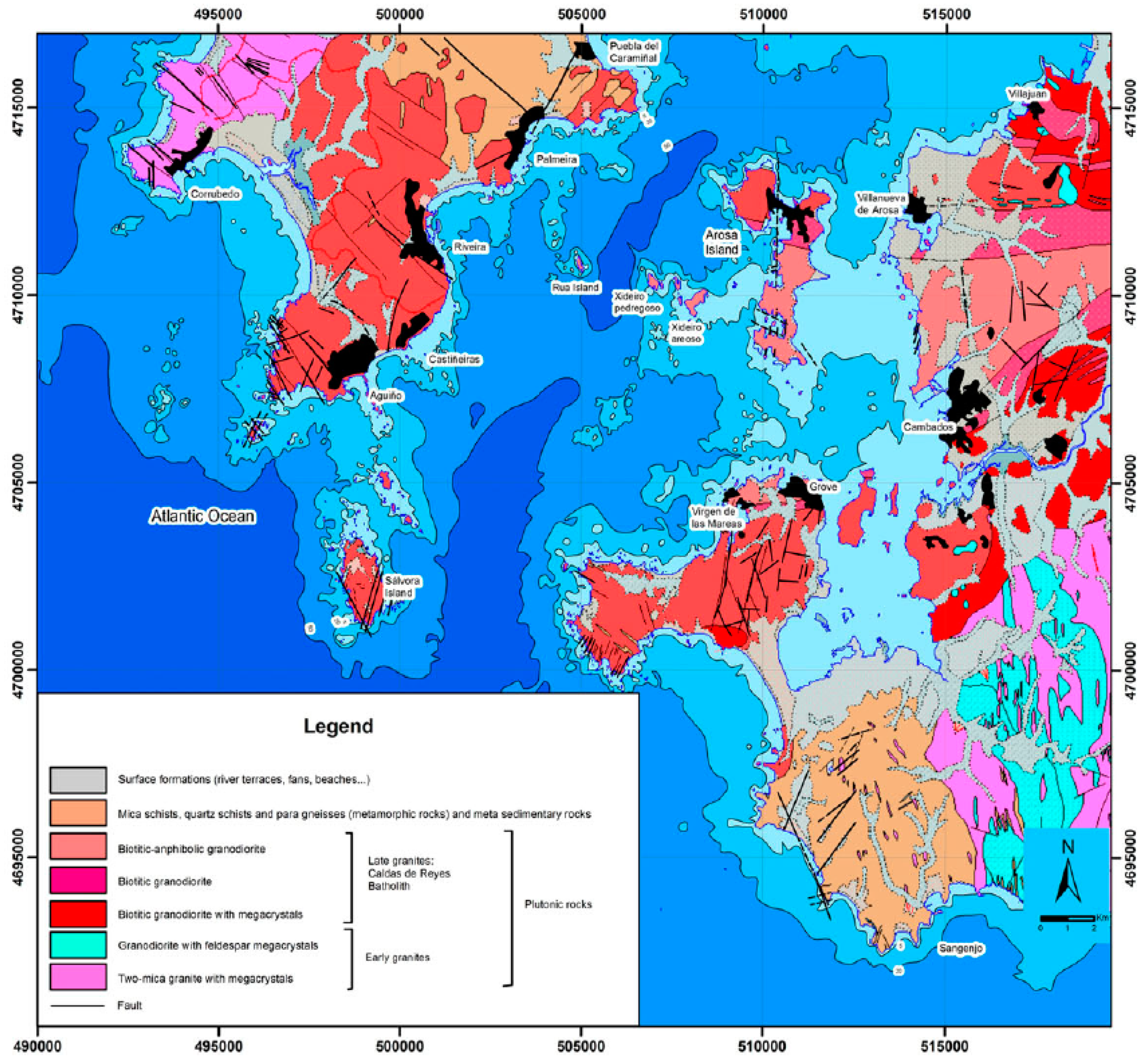
Galicia is located in the northwestern sector of the Variscan Massif, after an episode that occurred as a result of the clash between the continents of Gondwana and Laurentia. There are three differentiated geological domains around the Rías Bajas (Figure 2), based on their structural, tectonic and petrographic characteristics: Vigo-Pontevedra-Noya domain, the Migmatite and Granitic Rocks domain and Caldas de Reyes Granodiorite Domain. The Vigo-Pontevedra-Noya domain is a tectonic pit or “graben” formed by schists and gneisses originating between the Precambrian and the Cambrian. The Migmatite and Granitic Rocks domain, also called the Lage Group, can be divided into three complexes: the “Schisto-Grauvachic Complex”, the “El Rosal-La Lanzada” complex and the “Villagarcía-Cuntis” unit. Finally, the Late Carboniferous granitoid domain, or the Caldas de Reyes Granodiorite Domain, is defined by discordant contacts and originated after the Hercynian Orogeny (postkinematic). These domains are controlled by various factors such as the climate of the area, because physical–chemical alteration determines the characteristics of the rocks that form the substrate, the lithology determines the resistance of the rocks to weathering processes and erosion and marine dynamics determine coastal geomorphology.

2.3. Geomorphological Context

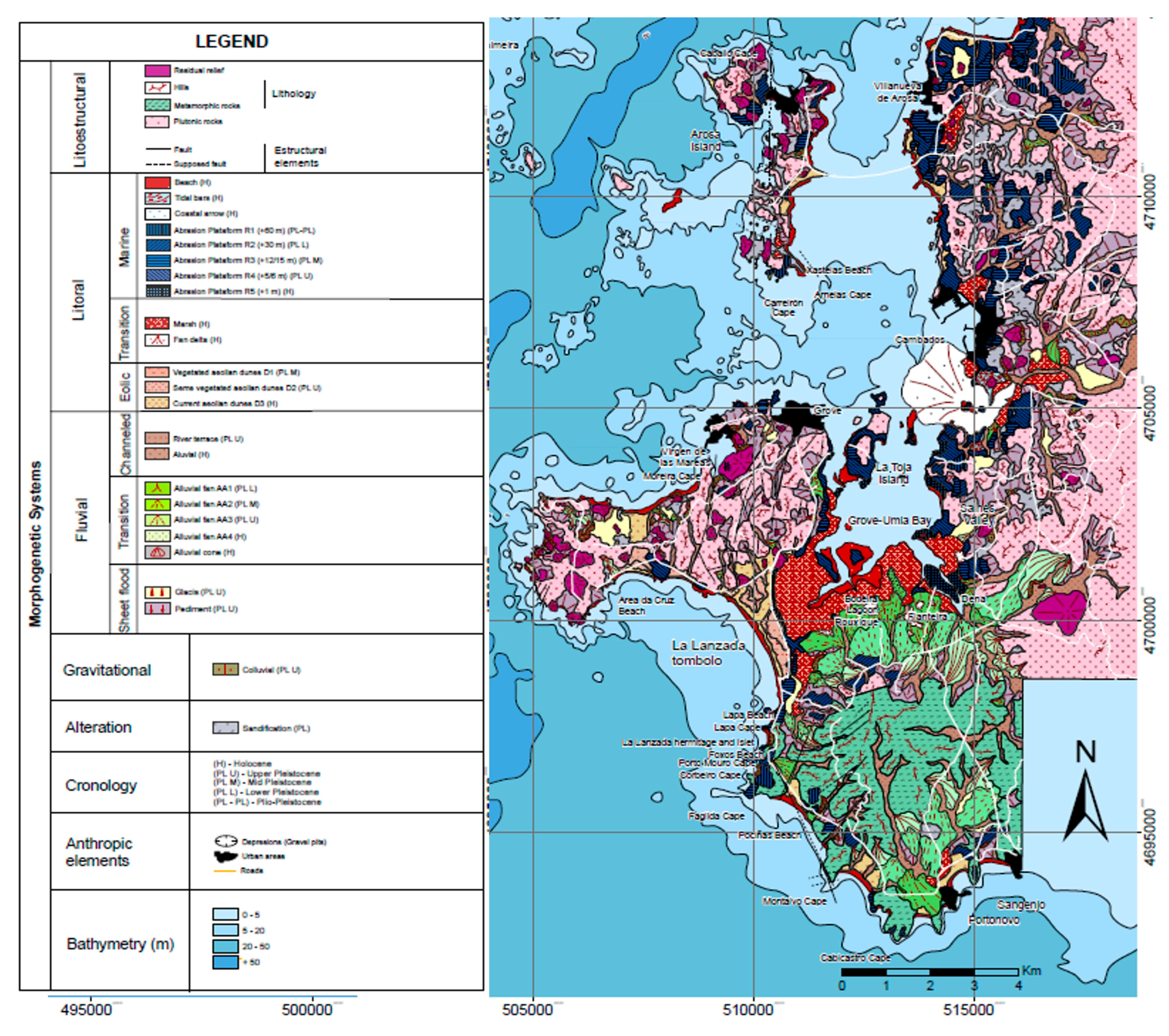
On the southern margin of the Arosa estuary we find different geomorphological units (Figure 3).
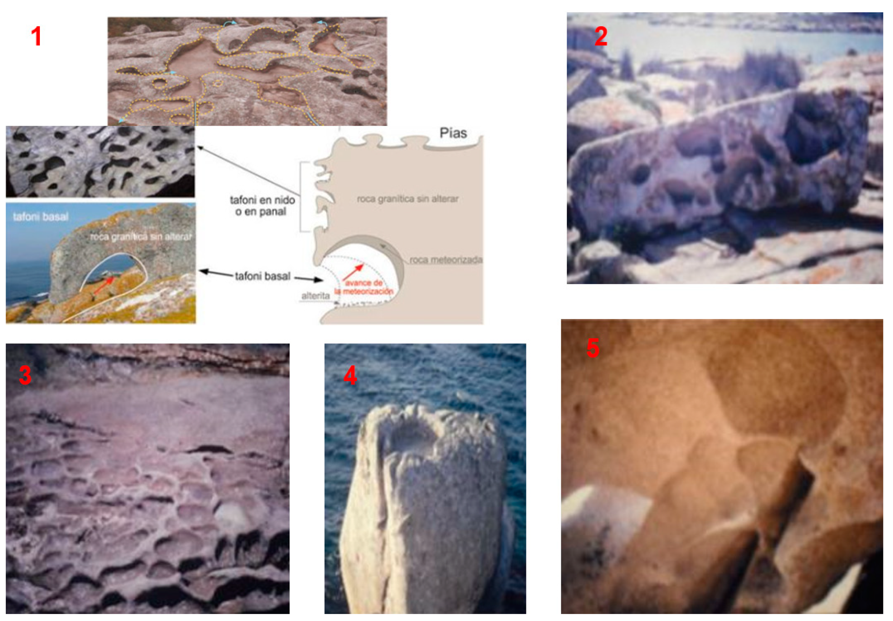
The lithostructural system of the Arosa estuary is characterized by the generation of inselbergs of magmatic origin and balconies, among other morphologies, which have been altered by external geological processes to define a granite model with different stages of erosion, differentiated by their dimensions on a large scale, such as the domes generated by a greater alteration in the slopes with respect to the highest areas and tors and stony slopes in the most developed areas of the domes. As smaller-scale forms, the gnammas and tafonis stand out, in whose development characteristic cavities known as honeycombing are generated. Likewise, landslides of the granite blocks are produced by their fragmentation, generating towers with suspended blocks or cavalry stones.
The coastal system originates as the zone of interaction or union between aquatic and terrestrial environments. The joint dynamics of waves, tides and currents generate different types of morphologies differentiated according to their origin: denudation or “destructive” processes or accumulation or “constructive” phenomena. In the marine environment, construction processes take place that generate forms of sediment accumulation differentiated according to their origin: allochthonous (river currents), para-autochthonous (wind origin and erosion of cliffs) and autochthonous (biological activity) [15]. Some examples are the beaches, the bars or the tombolos. As for the destructive processes of the marine environment, they are based on weathering such as marine terraces or flat ones.
In the transition environment, lagoons and marshes originate, which are forms of deposits of fine material originated from surface flooding, forming a humid ecosystem with a great wealth of biodiversity. In the wind environment, dunes differentiated by the type of vegetation and their age of formation originate. The dunes are accumulations of sand formed by the action of the wind, which grow from their centimeter scale in their initial states. In addition, they produce an exchange of sediments with the silvers, with which they are linked. There are several types, with desert (transversal, longitudinal, inverse, etc.) and coastal (embryonic, remontant or echo, among others) being the remontant the most characteristic in the area [16].
The fluvial system is characterized by the subsidence of blocks because during glacial periods erosion dominated, causing subsidence, while in interglacial periods the valleys were flooded. The morphology of the valley in the Arosa estuary is V-shaped. Within the channelized system are the floodplains and fluvial terraces, while in the transition system the alluvial fans and cones stand out. Finally, in the rolled system, foothills and glacis are formed.
Regarding the gravitational system, there are colluviums at the feet of the large granite rocks, since when the granite blocks are eroded or fractured they fall due to gravity. The phenomena are caused by microcracking and macrocracking due to small or large fractures in the blocks, by cryoclasty due to the freeze–thaw processes that cause water to penetrate through the fractures of the blocks, and by biological processes when the roots of higher plants penetrate into the fissures of the rock.
Regarding the alteration system, the granites are altered to different degrees depending on the speed of weathering and the area, being slower in the north. On the other hand, near the sea, chemical weathering will increase.

2.4. Methods

Geoheritage is a non-renewable resource whose degradation and alteration supposes a loss of scientific information and, therefore, of the knowledge of a part of the history of the Earth in each geosite that is destroyed or extracted. Currently, geoheritage is at risk due to increasing human activity and the pressure of anthropic activity (urbanizations, road infrastructure, unsustainable tourism with the deterioration and mismanagement of natural spaces, etc.). There is a need to conserve natural heritage, specifically geological heritage, which allows it to be used for scientific, educational, didactic, tourist/recreational and cultural purposes. For this, it is necessary to assess it for its protection and management geoheritage [7,17].

2.4.1. Geosite Evaluation

The first stage was to proceed by assessing the geosite considering three types of values: intrinsic, linked to the potentiality of use and the need for protection (this last parameter is valued once the other two have been valued).
The intrinsic value encompasses the parameters of representativeness (R: informs about the quality of the place to adequately illustrate the characteristics of the domain), type or reference locality character (T: informs about the quality of the place as a stratigraphic, paleontological, mineralogical, etc.), degree of scientific knowledge of the place (K: indicates that the geological relevance and scientific interest make it the object of scientific publications and studies), the state of conservation (C: indicates the greater or lesser ease that offers the environment to observe the feature), the observation conditions (O: indicates the greater or lesser facility that the environment offers to observe the feature), the rarity (A: reports the scarcity of features similar to the one described), geological diversity (D: reports the existence of various types of geological interest in the same place) and the spectacularity or beauty (B: reports the visual quality of the feature). For the intrinsic and use value, the parameters of content and informative use (Cdd: indicates whether the feature lends itself more or less easily to disclosure or is already used for this purpose), content and didactic use (Cdv: indicates whether the trait lends itself more or less easily to teaching or is already used for this purpose) and potentiality to carry out activities (Ptr: informs whether the place meets the conditions for carrying out leisure or recreational activities, or if it is already used for this purpose; also linked to the potentiality of use). The value of use takes into account the logistics infrastructure (Il: reports on the existence of accommodation and restaurants), the socioeconomic environment (Es: reports on the socioeconomic conditions of the region, which may favor the use of the place as a factor of local development) and the association of other elements of heritage (natural, historical, ethnological) (Nh: informs if the place also has other elements of non-geological interest, which can attract a greater number of visitors). Finally, the value linked to the need for protection takes into account the parameters of population density (Dp: linked to the potential number of visits but, on the other hand, to the greater possibility of acts of vandalism), accessibility (As: linked to a greater ease of visitor access but, on the other hand, to a greater ease for acts of vandalism), fragility or size of the geosite (E: indicates the ease of degradation of the place, due to its intrinsic characteristics: lithology, nature or dimensions) and proximity to recreational areas (Zr: indicates the presence of recreational or tourist areas near the place. Linked both to the potential number of visits and, conversely, to a greater possibility of acts of vandalism).
Next, the value of scientific, educational and tourist-recreational use was calculated by scoring the different parameters and multiplying by their weighting coefficients depending on the use; that is, each parameter was scored with a value from 0 to 4, and multiplied by their weight (Table 1).
Finally, each scientific (Vc), didactic (Vd) and tourist-recreational (Vt) value was determined by performing the following algorithm for each one (Equation (1)):
Vc = 1 / 40 × [ 30 × R + 15 × ( K + A ) + 10 + ( T + C + O + D ) ] Vd = 1 / 40 × [ 20 × Cdd + 15 × Tl + 10 × ( D + Ac ) + 5 × ( R + A + T + C + O + Dp + E + Nh + B ) ] V t = 1 / 40 × [ 20 × B + 15 × ( E + Cv ) + 10 × ( Ac + Es ) + 5 × ( O + Il + Dp + Nh + Ptr + Zr ) ]
If the final score of the geosite was higher than 6.65, it could be considered a Place of Geological Interest of very high value; if the score was between 3.33 and 6.65, it was a high value geosite; if it was less than 3.33 it was a geosite of average value; and finally, if the geosite had a score lower than 1.25 it was not included in the inventory.
In a second stage, the susceptibility and risk of degradation were assessed. Degradation susceptibility is the ease of degradation of a place of geological interest based on various factors such as size, fragility, or vulnerability that can be natural or anthropic. Therefore, fragility is the quality that a place of interest presents to be alterable due to its lithology or degree of weathering, among other characteristics.
The natural vulnerability (VN) evaluates the alteration produced by natural processes and threats in the place of geological interest, and in the event that the geodynamic processes that have formed the place are the same as those that cause its deterioration, called intrinsic vulnerability. On the other hand, the vulnerability is anthropic (VA) if it evaluates the deterioration of a place caused by actions and threats of human activities (constructions, mining activity, vandalism, etc.) that are important because they can be controlled and mitigated, unlike natural threats. Therefore, the natural vulnerability VN depends on the intensity and activity of the geological and biological processes on the geosite; according to the following formula (Equation (2)), the more fragile (F) the geosite, the more intense the alteration (AN) of natural processes:
VuN = F × AN
On the other hand, the anthropic vulnerability is expressed as the sum of various vulnerabilities (Equation (3)) according to the pressure exerted by the anthropic activity on the LIG: vulnerability due to water or mining interests (VuM), vulnerability due to the possibility of collection or looting (VuEX), vulnerability due to proximity to infrastructures (VuI) and general anthropic vulnerability (VuG) due to the fact that there is an anthropic activity.
VuA = VuM + VuEX + VuI + VuG
Therefore, the susceptibility to degradation (SD) is lower the larger the size of the geological interest site, represented by the following formula (Equation (4)), where EF is a factor inversely proportional to the size:
SD = Vu × EF
Therefore, the susceptibility to natural (SDN) and anthropogenic (SDA) degradation can be calculated with the following formulas (Equations (5) and (6)):
SDN = EF × VuN = EF × F × AN
SDA = EF × VuA = EF × (VuM + VuEX + VuI + VuAG)
Finally, the algorithm is used to determine SDA (Equation (7)):
SDA = EF × [25 × (VuM + VuEX) + 15 × VuI + 10 × AC + 5 × (P + PF + TS + DP + ZR)
Once the susceptibility and vulnerability of degradation have been evaluated, the risk of degradation (RD) can be determined, which is determined based on the degradation of the LIGs and the damage caused to the geological heritage, and is determined by the formula (Equation (8)):
RD = 1/10 × V × SD
Additionally, it is possible to determine the risk of degradation of each type of value (Equation (9)), scientific (Vc), didactic (Vd) and tourist-recreational (Vt), also discovering if the risk of degradation is due to natural causes (RDN) or anthropic (RDA):
RDNC = 1 / 10 × VC × SDN RDND = 1 / 10 × VD × SDN RDNT = 1 / 10 × VT × SDN RDAC = 1 / 10 × VC × SDA RDAD = 1 / 10 × VD × SDA RDAT = 1 / 10 × VT × SDA

2.4.2. Three-Dimensional Virtual Itinerary

The methodology followed to carry out the virtual itinerary of the 7 geosites consisted first of a compilation of the digital information of the different thematic layers: imported geological cartography in vector format and in kmz format, as well as a digital elevation model (DEM, spatial resolution 5 m). The orthophotos and satellite images were obtained from the platform of the National Geographic Institute of Spain in “raster” format. Subsequently, this information was integrated through a geographic information system, to be implemented in a virtual globe. Secondly, the 7 geosites were georeferenced and described, generating position marks with different symbols and adding field photographs, interpretive diagrams and valuation sheets for each site on the virtual globe [18,19,20,21,22].
The free and widely recognized platform Google Earth allows the export of georeferenced geosites in vector format (points) as a kml layer, or their generation with the “add” menu using a “placemark”. In the properties of each geosite, the user can add a description of the place and add different icons, in addition to adding photographs of the outcrop, structures or interpreted diagrams. This geoheritage information, implemented in Google Earth, allows the user to activate and deactivate each geosite, as well as modify it and add new images. The user can zoom in or out of each geosite, and, at higher zoom levels, the information (texts and images) and a descriptive text of geological-geomorphological interest are displayed. The user can superimpose georeferenced layers in “real time” of the territory that are of interest, such as roads, population centers, etc.
Next, we implemented didactic resources at each geosite in such a way that photographs were georeferenced and activated and could be shown when zooming in on each geosite, and could activate or deactivate the different resources that help us locate and interpret geological elements and structures. The overlay of photographs (unlike the thematic cartographies, which were georeferenced and exported in kml format from GIS to be overlaid on the 3D globe) was managed using algorithms integrated into Google Earth, capable of moving the figure both vertically and horizontally on the 3D globe. This allows you to interactively rotate the images by 360° and therefore view them from different positions. Finally, we uploaded digital information to the Google Earth platform to establish a series of 3D virtual flights on the itinerary. These were implemented in different formats (mpeg, avi, wma) so that they could be played on different multimedia systems (PC, DVD, etc.). The described methodology is compatible with the implementation of geoheritage cartography in web applications, viewers and geoportals, which allows the different thematic layers generated in this study to be supported in various applications of virtual viewers and geoportals [23,24,25,26,27,28,29,30,31]. This procedure facilitates the use of “augmented reality”, the purpose of which is to view and manage graphic information through an Internet browser, a mobile phone, a PDA or a laptop. These tools make it possible to integrate the geological structures that are seen on the ground at a given moment with the superimposition of interpreted images or schemes in the virtual reality of the smartphone so that users can search, visualize and combine information on geoheritage and geodiversity. This methodology aims to disseminate heritage information and apply geospatial resources in research, education, didactics and geotourism applications for their valorization and conservation.

3. Results and Discussion

3.1. Geosites Description

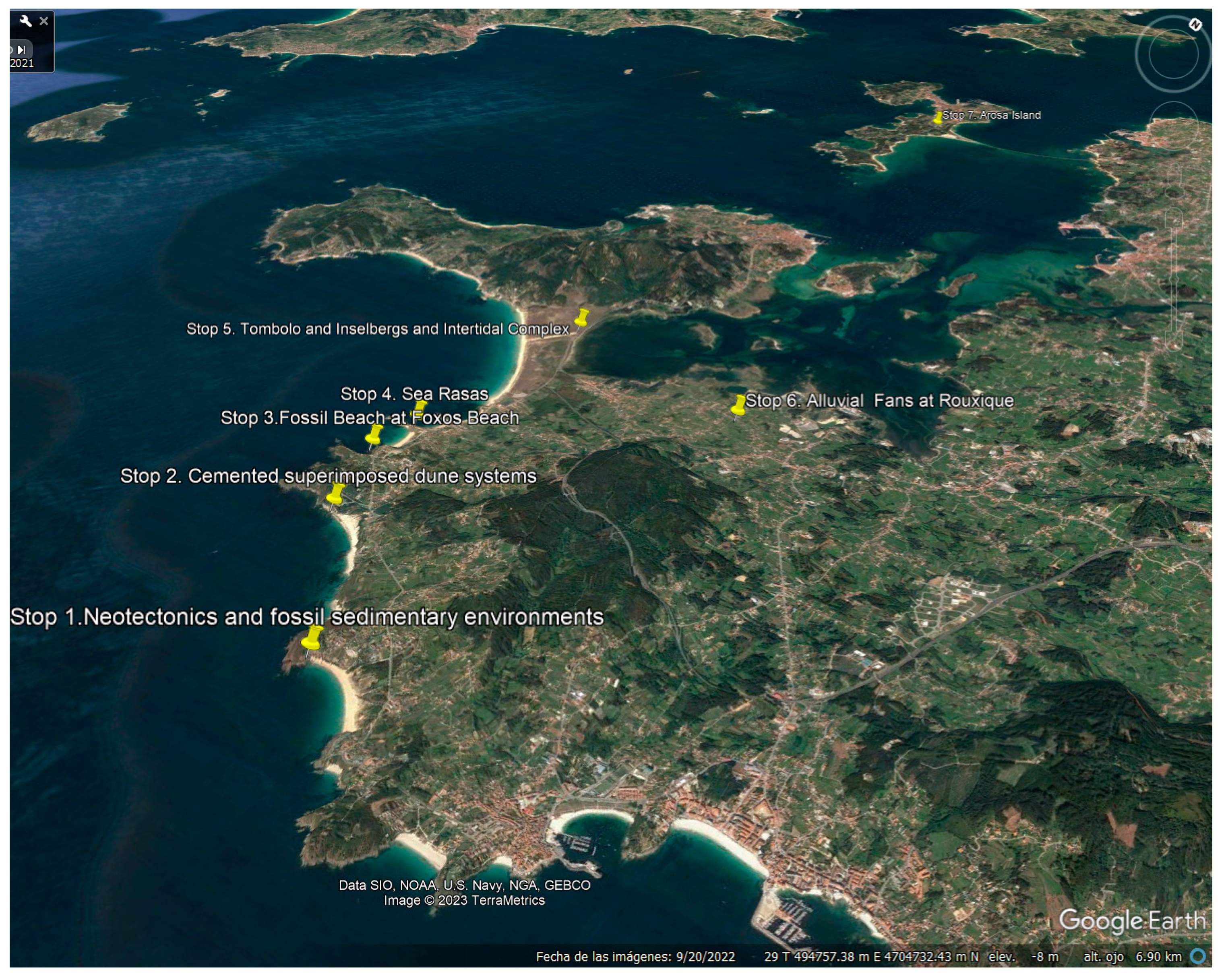
Seven geosites were identified, which from south to north are the following (Figure 4):
The geosites are described below in order to proceed with their assessment.
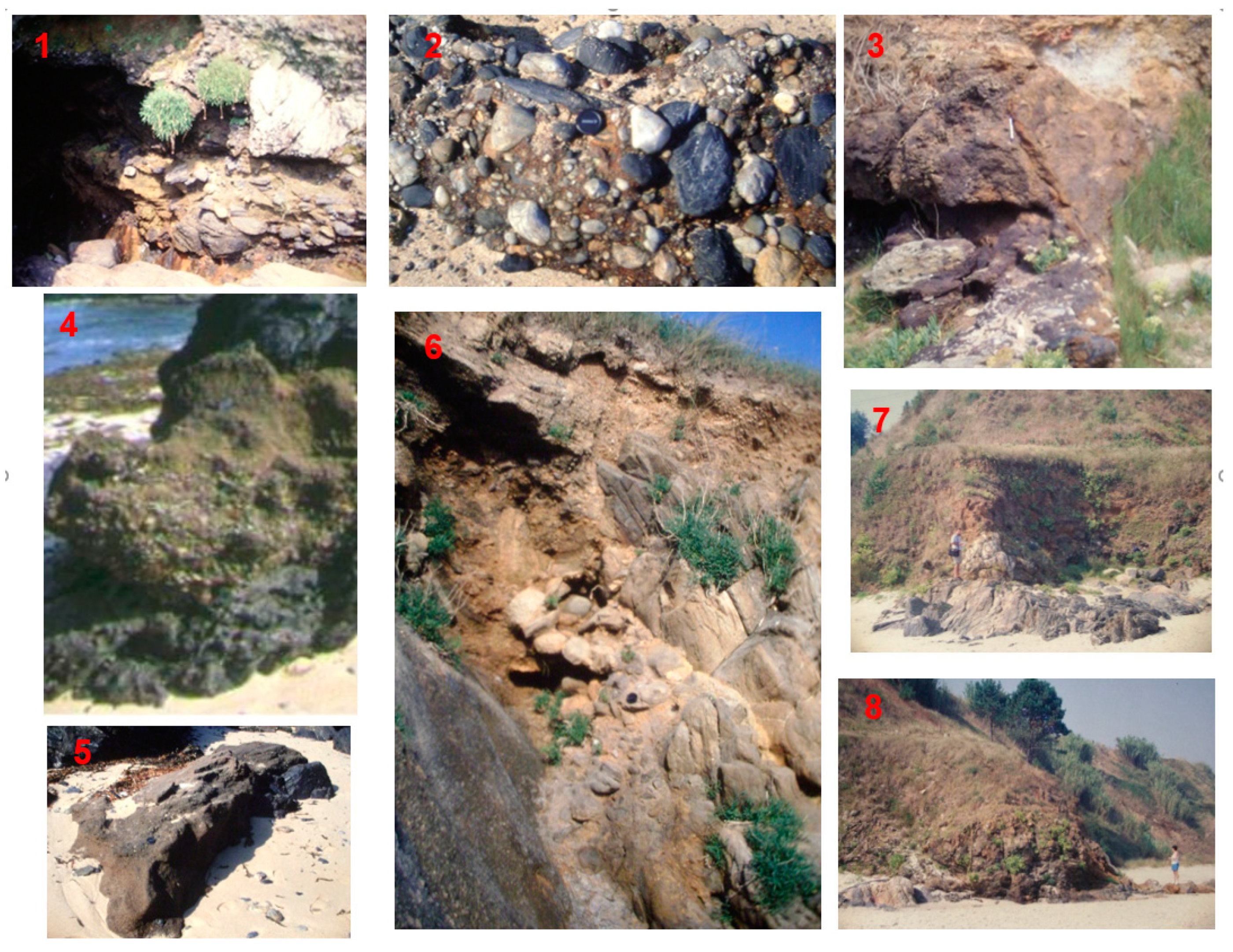
Stop 1. Neotectonics and fossil sedimentary environments. In this geosite, we observed a normal fault that cut the paleobeach of the last interglacial. Fossil dune systems, notches in Playa de Pociñas and paleoseismic structures were also observed in this sector.
This geosite is located on the coast of the Castrove Peninsula. Along the northern sector of Pociñas Beach there are conglomerates that correspond to a paleo-beach from 130,000 years ago affected by a normal fault with direction N 160° E. The area is located on the ledge of Punta Montalvo, which constitutes a level with an elevation of 50 m. In Punta Montalvo, this normal fault can be observed (Figure 5) in whose raised block (left) is located the fault plane on which the vertical displacement has occurred, which affects two colluvial sequences (C3 and C4) located on the marine deposits of the last interglacial conglomerate that reach up to 5.5 m in height. On the sunken right block, the current marine abrasion platform of metamorphic substrate has been developed with the fossil beach at a height of 3 m, on top of which up to four colluvium sequences have been deposited (C1, C2, C3 and C4). In the C3 colluvium there are paleoseismic structures such as micro-diapirs and micro-thrusts.
The micro-diapyrs are formed by the injection of fine material into the sediments, sands or conglomerates, and the micro-thrusts are formed obliquely to the direction of colluvium deposition, indicating neo-tectonic activity at least during the deposition of this C3 colluvium [32].
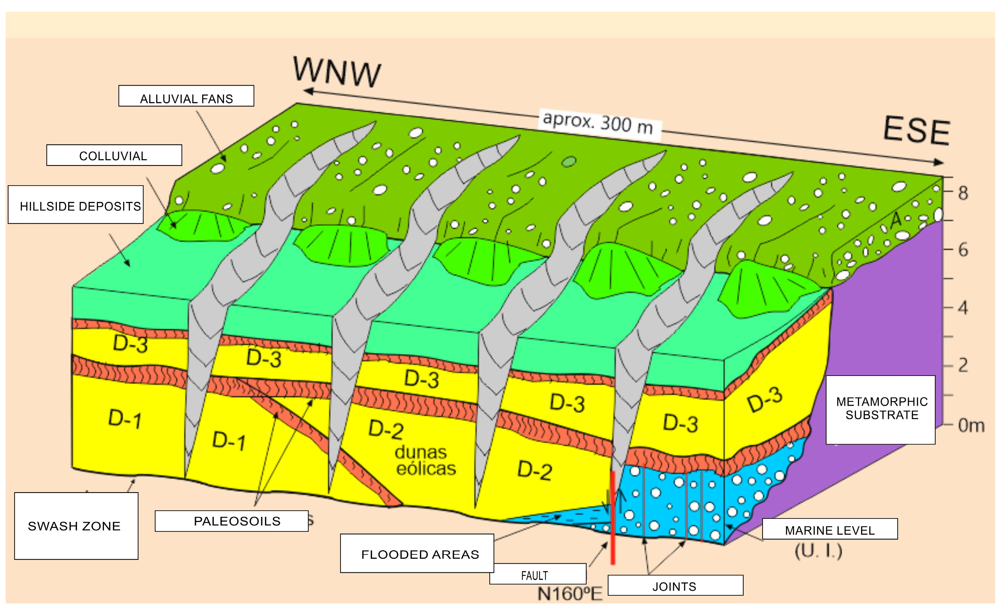
Stop 2. Cemented superimposed dune systems. In this geosite, we observed rampant dunes in three sequences (D-1, D-2 and D-3) that migrate in a WNW direction and are located on a conglomerate affected by the N 160° E normal fault. Due to the displacement of the fault, sequences of aeolian deposits and flooding zones have been formed (Figure 6). In the case of this beach, there are dune sequences and the normal fault N 160° E, affecting the height of the paleobeach and, in addition, the deposition of these dunes depending on whether they are on one side or the other of the fault. An alteration is observed in the separation of the D-2 dune system with respect to D-3, but also affecting the marine level of conglomerates from the Last Interglacial, which indicates that the movement of the fault has stopped between these two sequences. On the same beach, to the south, there are also undercuts formed by the shock of the waves on the walls of the cliffs until they are eroded at the base, which produces instability, and can cause their collapse and their retreat [32].
The exact chronology of sedimentary sequences such as conglomerates cemented by iron oxides or ferruginized is difficult to determine because no fauna can be found that can be dated, but in other coastal areas there are gastropods between 36,000 and 38,000 yBP, which places them in the last interglacial, thus making it a paleobeach prior to the last glaciation [32], while the dune and colluvium deposits are more modern, from the last glacier.
Stop 3. Fossil Beach at Foxos Beach. Foxos Beach is located to the south of the islet and Hermitage of La Lanzada. On this beach, a fossil beach can be seen in the form of black and cemented conglomerates (Figure 7). It is in this zone where the contact between the most fragile metamorphic rocks with respect to the granite of the Caldas de Reyes pluton appears. The curved shape contact has a SW-NE direction from the north of Foxos Beach towards the interior of the Castrove Peninsula, where it is covered with alluvial fan sediments. Foxos Beach is located on a coastal strip of 5–6 m. It is low-lying and without a deposit, such as the Hermitage of La Lanzada or some subordinate ones, such as the islet of La Lanzada, which will be the next geosite.
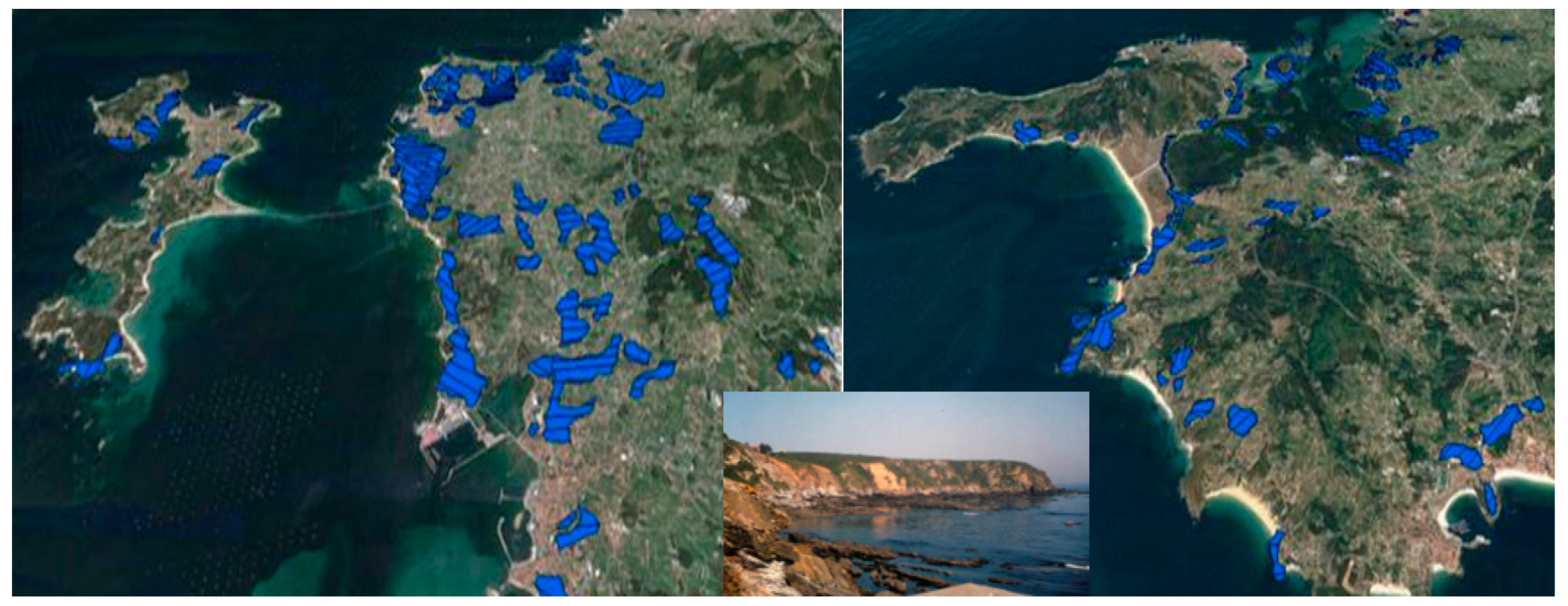
Stop 4. Sea Rasas. In this geosite, up to three levels of shallows can be observed on the islet of La Lanzada, the Hermitage of La Lanzada and in the surroundings there is impressive spheroidal weathering. The rasas are old platforms of marine abrasion, very characteristic of the landscape of the Galician western coast (Figure 8). The southern bank of the Arosa estuary is characterized by this type of surface at different heights without exceeding 60 m. These surfaces can be interpreted as a consequence of the formation of fluvial terraces due to a rise in sea level during the early Quaternary, due to coastal elevation since the late Pliocene. There are terraces without deposits, in which the sediments have been eroded by the action of the sea and redistributed along the coast. The high level is 25–30 m, the intermediate level is 12–15 m and made up of altered substrate materials, and finally the low level includes levels of 5–6 m and the current abrasion surface at 1 m submerged. At high tide, on the micro-cliff that forms to the south of La Lanzada beach at the end of the ledge where the Hermitage of La Lanzada is located, the phenomenon of sand formation that will give rise to spheroidal weathering can be observed. Erosive agents such as water or air penetrate the fractures of the rocks, causing their weathering through processes such as hydrolysis, by contact with salt water and rock, forming so-called “sanding corridors” around the cores of the blocks and giving rise to more rounded geometries, forming bowling pins. Once the alteration product erodes, these granitic spheroidal morphologies are exposed.
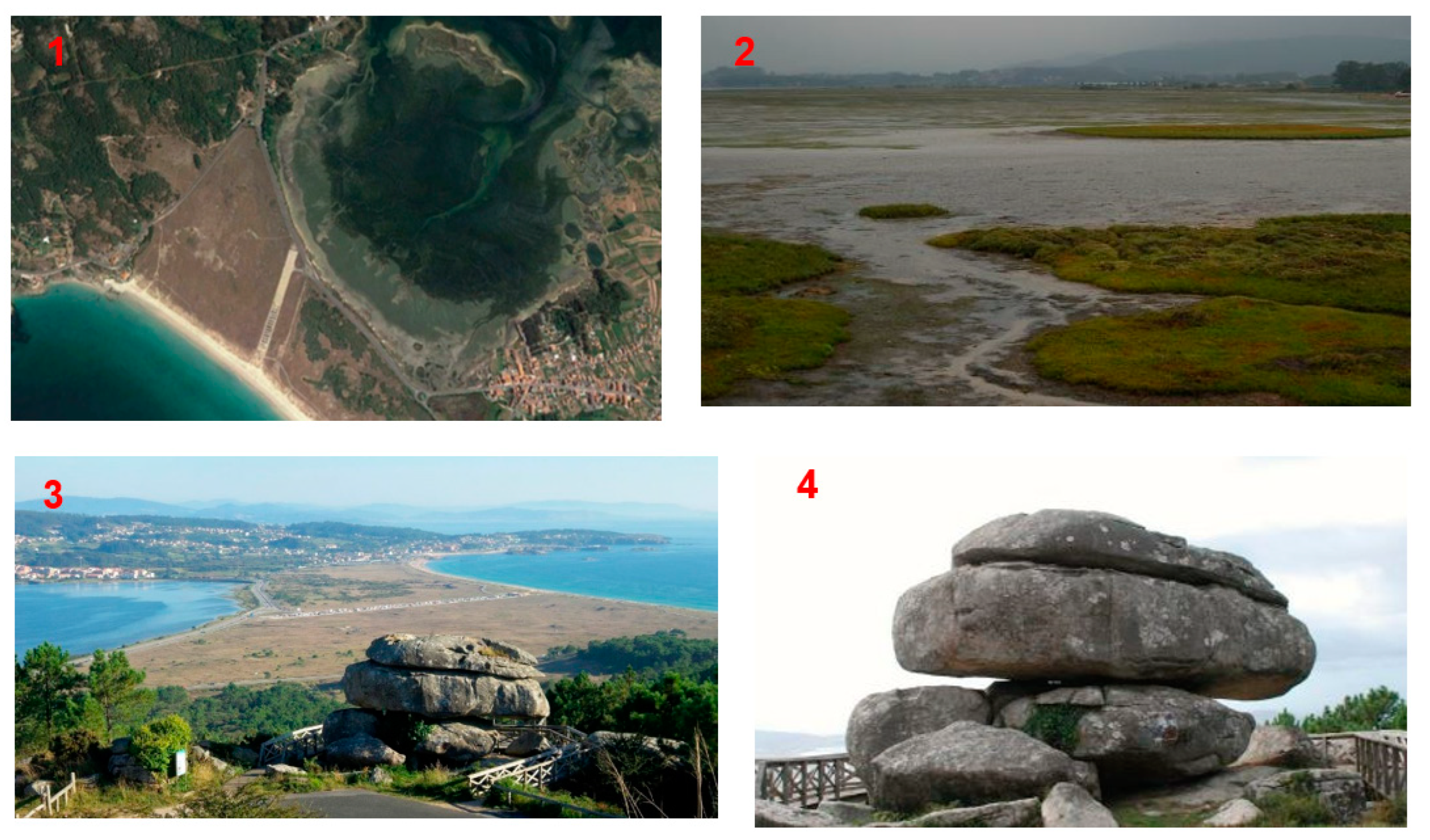
Stop 5. Tombolo and Inselbers and Intertidal Complex. The tombolo of La Lanzada joins the continent to the old Isla del Grove. The tombolo of La Lanzada has a length of about 13 km, increasing its width towards El Grove. In the tombolo there is a sequence of rampant or rising dunes of up to three dune systems that, due to the wind, rise up the slopes and adapt to the shape of the relief of the grove peninsula. Additionally, we find “echo dunes” that are generated by the shock of the suspended sand that is deposited at the foot of the relief against which it collides, remaining parallel [16].
The formation of lagoons are typical morphologies, sometimes due to human influence due to the indiscriminate extraction of sand. On other occasions, the lagoons originate highly mature marshes due to the continuous fluvial contribution, acting as forms of deposit and sedimentation, such as the most extensive ones located to the south of the Isla de Arosa, in the Umia-O Grove Intertidal Complex (Figure 9). The Umia-O Grove Intertidal Complex is formed due to the mouth of the Umia River, which originates a shallow intertidal zone. For this reason, it presents a great wealth of biodiversity and is protected by different figures of the Natura 2000 Network as a Site of Community Importance (SCI) and a Special Protection Area for Birds (ZEPA) for its ornithological richness, among other reasons.
Standing out in the relief of the Grove peninsula are cavalry stones such as those of Monte Xiradella (Figure 9). The granite reliefs present different superficial (inselbergs, domes, etc.) and internal (taffonis, gnamas, etc.) geoforms as a result of differential erosion on the plutonic masses. The first phase of differential modeling is based on chemical alteration, while the second is the dismantling of this material altered in the first phase.
This process is controlled by a series of variables such as the composition, which controls the speed at which the alteration is carried out, the texture, which determines the resistance capacity of the rock to weathering (more resistance the less porosity) and the cracking, which determines the possibility of weathering affecting internal layers.
Stop 6. Alluvial Fans at Rouxique. In this geosite, we observed sequences of alluvial fans, deltaic cone and granite alteration fronts generating kaolin (Figure 10). The formation of alluvial fans is directly related to fluvial courses, whose main determining factor is rainfall. In the formation of fans, the high precipitation and the slope of the relief favors runoff and sedimentation in the coastal plain. The fans present in this area are inactive in terms of the contribution of sediments, and reflect the activity of fluvial courses from past times, with the exception of the Umia river, which is still active. In the case of the contributions from the Umia river, these deposits constitute an actual delta of flow and reflection in a westerly direction. To the south of the Umia river, the fans belonging to the Umia-Grove zone are found in a kaolin alteration front, being in this case the advance of the fans to the north since they come from a mountainous front in a SW-NE direction.
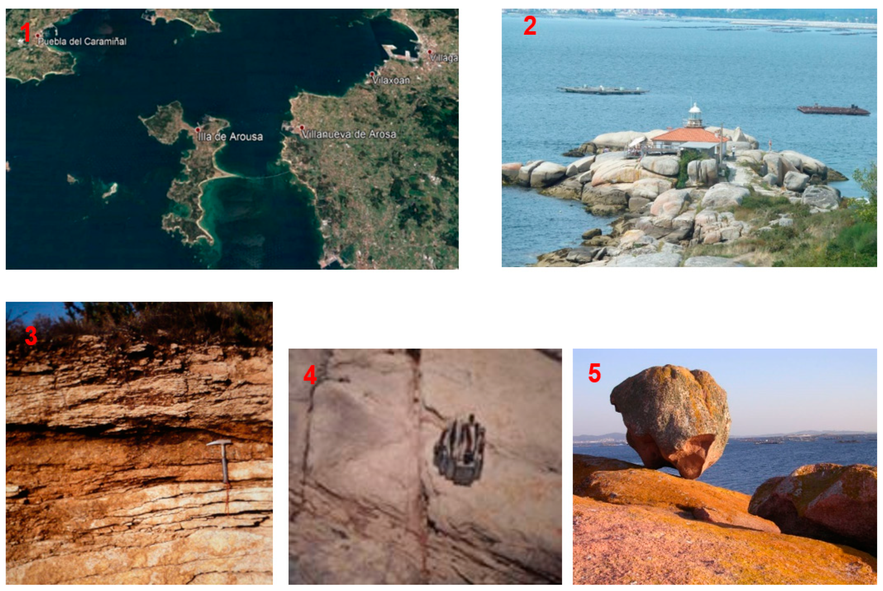
Stop 7. Arosa Island. Arosa Island. In this geosite, we can see the tombolo of the Isla de Arosa, decompression fractures, pias and taphonis, and an abrasion platform on temples. The southern sector of the island of Arosa presents a tombolo that joins the Carreirón Natural Park with the rest of the island of Arosa. The Island of Arosa was made up of three islets that have been joined by sand tombolos favored by the formation of fleche spor on the coastal dynamics and grouping the three islands into one: the island of Arosa. In the southern zone, we can observe numerous decompression fractures or joints, which initially originate as microcracks or microfractures produced by the release of gaining surface due to the removal of sediments eroded on the surface (Figure 11). In this geosite, the decompression of the granite masses causes a lajamiento that allows the circulation of water in the subsoil. It is worth highlighting the outcrop at the northern end of the island of syenite-type rocks that give a reddish color to the abrasion surfaces carved by the action of waves and currents.

3.2. Geoheritage Evaluation

Each geosite was evaluated by taking into account different parameters, obtaining the following results (Table 2).
We observed that the highest value was obtained by the Isla de Arosa (Stop 7) due to its geodiversity and the variety of geological oddities that can be seen in this sector, in addition to its presenting great naturalness and a very low anthropic state, and for this reason there are areas protected by specific regulations. The second-most-valued geosite was that of Tombolo de la Lanzada (Stop 5), since it constitutes a very well-developed sedimentary environment with diverse systems of dunes and associated fauna and vegetation of interest, bordering on the protected space of the intertidal complex. The rest of the geosites presented specific interests on aspects related to tectonics, geomorphology and mineral resources with an interval of values between 36 and 39, constituting more specific points and less geodiversity, although they do present remarkable geoheritage in their field.
Regarding the values of the geosites studied, we can indicate susceptibility and the risk of degradation (Table 3), and it was observed that the highest values of scientific interest were found in Stops 1 and 2, with a value of 230 (5.8 points, or high value), while the value of greatest didactic or educational interest stands out for Stop 7, with 245 (6.1 points, or very high value), leaving Stop 5 with the greatest recreational and tourist interest, obtaining 260 (6.5 points, or very high value).
For the values of susceptibility and risk of degradation (Table 4), it was observed that the highest susceptibility to natural degradation was found in Stop 2, and anthropic degradation occurred in Stops 1 and 3. Regarding the highest values of the risk of natural degradation, they were located, for scientific, didactic or educational, and tourist or recreational interest, in Stop 2, while the risk of anthropic degradation, for scientific, didactic or educational, and tourist or recreational interest, was located in Stops 1 and 3.

3.3. Three-Dimensional Virtual Itinerary

An itinerary was carried out once the location, identification, description and assessment had been carried out according to the methodology considering the Places of Geological Interest. The itinerary consisted of a tour in Google Earth of all the places and points of interest in the study area, indicated with yellow position marks and accompanied by layers in kml format, such as the geological map, a brief description and photographs of the rock outcrop, structure or morphology of interest. Once the route has been completed, it is possible to carry out virtual flights of the itinerary that can be obtained in different formats to be uploaded on platforms of geological interest, such as websites or geoportals, accessible from any electronic device that has internet, and thus the information is available and can promote knowledge of the geological heritage.
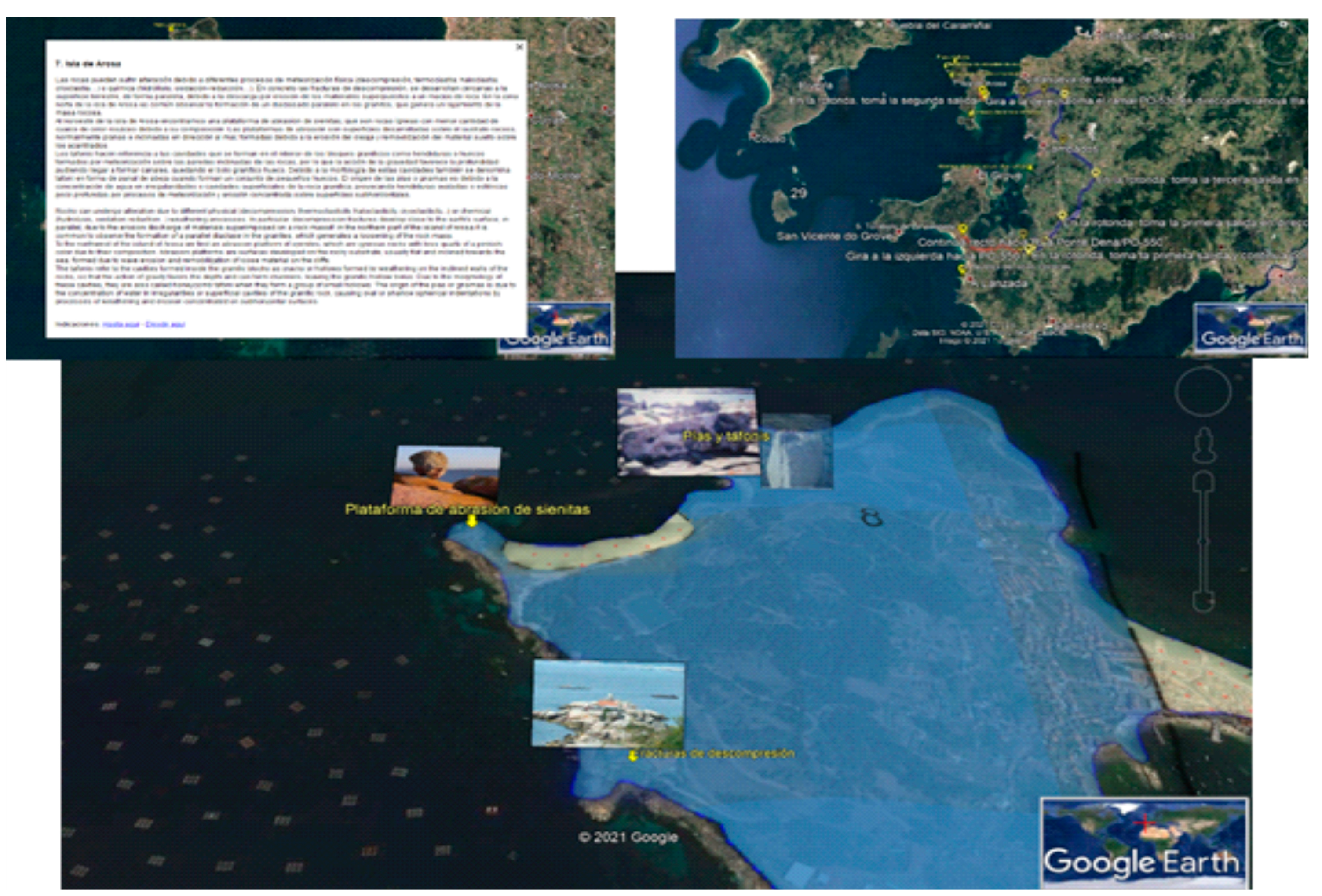
At each stop, a brief description of the place of interest and points is made, adding photographs of the place of interest, such as some representative ones where you can see the tombolo, the cavalier stones and the marshes of the Umia-O Grove Intertidal Complex. The route can be obtained automatically from the data of the georeferenced points, and with the GPS of a smartphone the platform itself traces the route and includes the directions from one stop to the next, in this case from the fifth stop “Tombolo de La Lanzada” to the sixth “Alluvial Fans”. It can also be drawn using the “Add a Path” tool with Google Earth. In addition, thematic layers such as geological cartography or the elevation profile of the route can be superimposed (Figure 12). Another example is the geosite “Isla de Arosa”, which includes the pias and taphonis morphologies, the decompression fractures and the syenite abrasion platform (Figure 13).

4. Conclusions

The Galician coast is intensely used by tourism and presents the following features: (1) unique geomorphological and landscape aspects; and (2) evident and observable examples of coastal geological processes. These coastal records allow us to know the history of the recent past and its environmental evolution. These characteristics allow the valuation of its geoheritage to reach high scores, either globally or through assessing the scientific, educational, and tourist-recreational interest.
This geological wealth constitutes a non-removable resource, so to promote its geo-conservation we must know and value these points so that society understands its meaning and value for its scientific, educational and tourist use, it being a sustainable natural resource that allows specialized geotourism through a descriptive itinerary complemented by geological cartography, photographs and descriptions.
The constant erosion of the flow of uncontrolled tourism and a lack of awareness of the natural values of this sector of study can lead to the alteration of the natural geosystem, negatively affecting the fauna and flora associated with these habitats protected by the Natura 2000 network.

Author Contributions

Conceptualization, A.M.-G. and J.A.G.-D.; methodology, V.V.; software, A.M.-G.; validation, V.V. and T.C.; formal analysis, C.N.; investigation, V.V. and C.N.; resources, V.V. and C.N.; data curation, T.C.; writing—original draft preparation, A.M.-G.; writing—review and editing, J.A.G.-D.; visualization, V.V.; supervision, J.A.G.-D.; project administration, A.M.-G.; funding acquisition, A.M.-G. All authors have read and agreed to the published version of the manuscript.

Funding

This research was supported by Spanish MCIN/AEI/10.13039/501100011033 and the GEAPAGE research group (Environmental Geomorphology and Geological Heritage) of the University of Salamanca.

Data Availability Statement

No applicable.

Acknowledgments

Acknowledgement is due to the members of the GEAPAGE research group (Environmental Geomorphology and Geological Heritage) of the University of Salamanca for their participation in field work.

Conflicts of Interest

The authors declare no conflict of interest.

References

  1. Díaz-Martínez, E.; Salazar, Á.; Cortés, Á.G. El patrimonio geológico en España. Enseñanza Cienc. Tierra 2014, 22, 25. [Google Scholar]
  2. Méndez, G.; Rey, D. Perspectiva histórica del conocimiento geológico de las rías gallegas. J. Iber. Geol. 2000, 26, 21–44. [Google Scholar]
  3. Nonn, H. Los sedimentos antiguos de la Arosa estuary. Algunas conclusiones geomorfológicas. Notas Comun. Inst. Geológico Min. España 1964, 74, 143–155. [Google Scholar]
  4. Sole Sabaris, L.; De teran, M.; Otros. Geografía Regional de España. Tomo II; Editorial Ariel S.A.: Madrid, Spain, 1983; pp. 31–58. [Google Scholar]
  5. Martín Serrano, A. El relieve del Macizo Hespérico: Génesis y cronología de los principales elementos morfológicos. Cuad. Lab. Xeolóxico Laxe 1994, 19, 37–56. [Google Scholar]
  6. Martínez-Graña, A. Formación y Dinámica de las Rías Gallegas; de Pesca, C., Ed.; Xunta de Galicia: Madrid, Spain, 1994; pp. 1–36. [Google Scholar]
  7. García-Cortés, Á.; Carcavilla, L.; Vegas, J.; Díaz-Martínez, E. Documento Metodológico para la Elaboración del Inventario Español de Lugares de Interés Geológico; Instituto Geológico y Minero de España, IGME: Madrid, España, 2018; Available online: http://www.igme.es/patrimonio/descargas/METODOLOGIA%20IELIG%20V16%20actualizaci%C3%B3n%202018.pdf (accessed on 15 April 2023).
  8. Carcavilla Urqauí, L.; López Martínez, J.; Durán Valsero, J.J. Patrimonio Geológico y Geodiversidad: Investigación, Conservación, Gestión y Relación con los Espacios Naturales Protegidos; Instituto Geológico y Minero de España (IGME), Ministerio de Educación y Ciencia, Cuadernos Museo Geominero: Madrid, Spain, 2007; Volume 7, p. 360. [Google Scholar]
  9. Carcavilla, L.; Durán, J.J.; y López-Martínez, J. Geodiversidad: Concepto y relación con el patrimonio geológico. Geo-Temas 2008, 10, 1299–1303. [Google Scholar]
  10. Pescatore, E.; Bentivenga, M.; Giano, S.I. Geoheritage and Geoconservation: Some Remarks and Considerations. Sustainability 2023, 15, 5823. [Google Scholar] [CrossRef]
  11. Zakharovskyi, V.; Németh, K. Quantitative qualitative method for quick assessment of geodiversity. Land 2021, 10, 946. [Google Scholar] [CrossRef]
  12. Brilha, J. Inventory and quantitative assessment of geosites and geodiversity sites: A review. Geoheritage 2016, 8, 119–134. [Google Scholar] [CrossRef]
  13. Fepuleai, A.; Weber, E.; Németh, K.; Muliaina, T.; Lese, V. Eruption styles of Samoan volcanoes represented in tattooing, language and cultural activities of the indigenous people. Geoheritage 2017, 9, 395–411. [Google Scholar] [CrossRef]
  14. Zakharovskyi, V.; Németh, K. Comparison of different scales of qualitative-quantitative as-sessment of geodiversity. Geographies 2022, 12, 45–55. [Google Scholar]
  15. Pedraza Gilsanz, J.D. Geomorfología: Principios, Métodos y Aplicaciones; Rueda: Madrid, Spain, 1996. [Google Scholar]
  16. Sanjaume, E.; Gracia, F.J. Las Dunas en España; España: Cadiz, Spain, 2011. [Google Scholar]
  17. Sánchez-Ferris, E.J.; Fierro-Bandera, I.; Aberasturi-Rodríguez, A.; Navarro-Pedreño, J.; Montoya-Belló, P. La valoración del patrimonio geológico y paleontológico como herramienta de gestión: El Modelo FOPALI. Span. J. Palaeontol. 2019, 34, 35–56. [Google Scholar] [CrossRef]
  18. Martínez-Graña, A.M.; Goy, J.L.; González-Delgado, J.Á.; Cruz, R.; Sanz, J.; Cimarra, C.; De Bustamante, I. 3D virtual itinerary in the geoheritage from natural areas in Salamanca-Ávila-Cáceres, Spain. Sustainability 2019, 11, 144. [Google Scholar] [CrossRef]
  19. Hincapie, M.; Cifuentes, L.M.; Valencia-Arias, A.; Quiroz-Fabra, J. Geoheritage and immersive technologies: Bibliometric analysis and literature review. Episodes 2022, 46, 022016. [Google Scholar] [CrossRef]
  20. Garofano, M. Geowatching, a term for the popularisation of geological heritage. Geoheritage 2015, 7, 25–32. [Google Scholar] [CrossRef]
  21. Newsome, D.; Dowling, R. Geoheritage and geotourism. In Geoheritage: Assessment, Protection, and Management; Elsevier Inc.: Amsterdam, The Netherlands, 2018; pp. 305–321. [Google Scholar] [CrossRef]
  22. Pica, A.; Reynard, E.; Grangier, L.; Kaiser, C.; Ghiraldi, L.; Perotti, L.; Del Monte, M. GeoGuides, Urban Geotourism Offer Powered by Mobile Application Technology. Geoheritage 2018, 10, 311–326. [Google Scholar] [CrossRef]
  23. Graña, A.M.M.; Goy, J.L.; Zazo, C. Cartografia geomorfologica y patrimonio geologico Cuaternario en la Arosa estuary (Pontevedra-La Coruña, Galicia, España). Contrib. Estud. Periodo Cuatern. 2007, 229–230. [Google Scholar]
  24. Gül, M.; Küçükuysal, C. Geotourism activities via marine excursion: Muğla, SW Türkiye. Geoheritage 2023, 15, 64. [Google Scholar] [CrossRef]
  25. Stanley, K.B.; Resler, L.M.; Carstensen, L.W. A Public Participation GIS for Geodiversity and Geosystem Services Mapping in a Mountain Environment: A Case from Grayson County, Virginia, U.S.A. Land 2023, 12, 835. [Google Scholar] [CrossRef]
  26. Silva, J.P.; Rodrigues, C.; Pereira, D.I. Mapping and Analysis of Geodiversity Indices in the Xingu River Basin, Amazonia, Brazil. Geoheritage 2015, 7, 337–350. [Google Scholar] [CrossRef]
  27. Bétard, F.; Peulvast, J.-P. Geodiversity Hotspots: Concept, Method and Cartographic Application for Geoconservation Purposes at a Regional Scale. Environ. Manag. 2019, 63, 822–834. [Google Scholar] [CrossRef]
  28. Vital, H.; Domínguez, J.M.L.; Bastos, A.C.; de Araújo, T.C.M. Geodiversidad y Biodiversidad de la Plataforma Tropical del Nordeste de Brasil. In Tropical Marine Environments of Brazil. La Serie de Libros de Estudios Latinoamericanos; Dominguez, J.M.L., de Kikuchi, R.K.P., Filho, M.C.d.A., Schwamborn, R., Vital, H., Eds.; Springer: Cham, Switzerland, 2023. [Google Scholar] [CrossRef]
  29. Martinez-Graña, A.M.; Goy, J.L.; Cardeña, C.Z. Natural heritage mapping of the las batuecas-sierra de Francia and Quilamas Nature Parks (SW Salamanca, Spain). J. Maps 2011, 7, 600–613. [Google Scholar] [CrossRef]
  30. González-Delgado, J.A.; Martínez-Graña, A.; Holgado, M.; Gonzalo, J.C.; Legoinha, P. Augmented Reality as a Tool for Promoting the Tourist Value of the Geological Heritage around Natural Filming Locations: A Case Study in “Sad Hill” (The Good, the Bad and the Ugly Movie, Burgos, Spain). Geoheritage 2020, 12, 34. [Google Scholar] [CrossRef]
  31. Marino Alfonso, J.L.; Poblete Piedrabuena, M.A.; Beato Bergua, S. Paisajes de Interés Natural (PIN) en los Arribes del Duero (Zamora, España). Investig. Geográficas 2020, 73, 95–119. [Google Scholar] [CrossRef]
  32. Graña, A.M.M.; Goy, J.L.; Zazo, C. Actividad tectónica en el Noroeste Peninsular, en base a los registros de los depósitos costeros de los últimos 130.000 años (rías Arosa-Pontevedra, Galicia). Geotemas 2000, 1, 263–266. [Google Scholar]
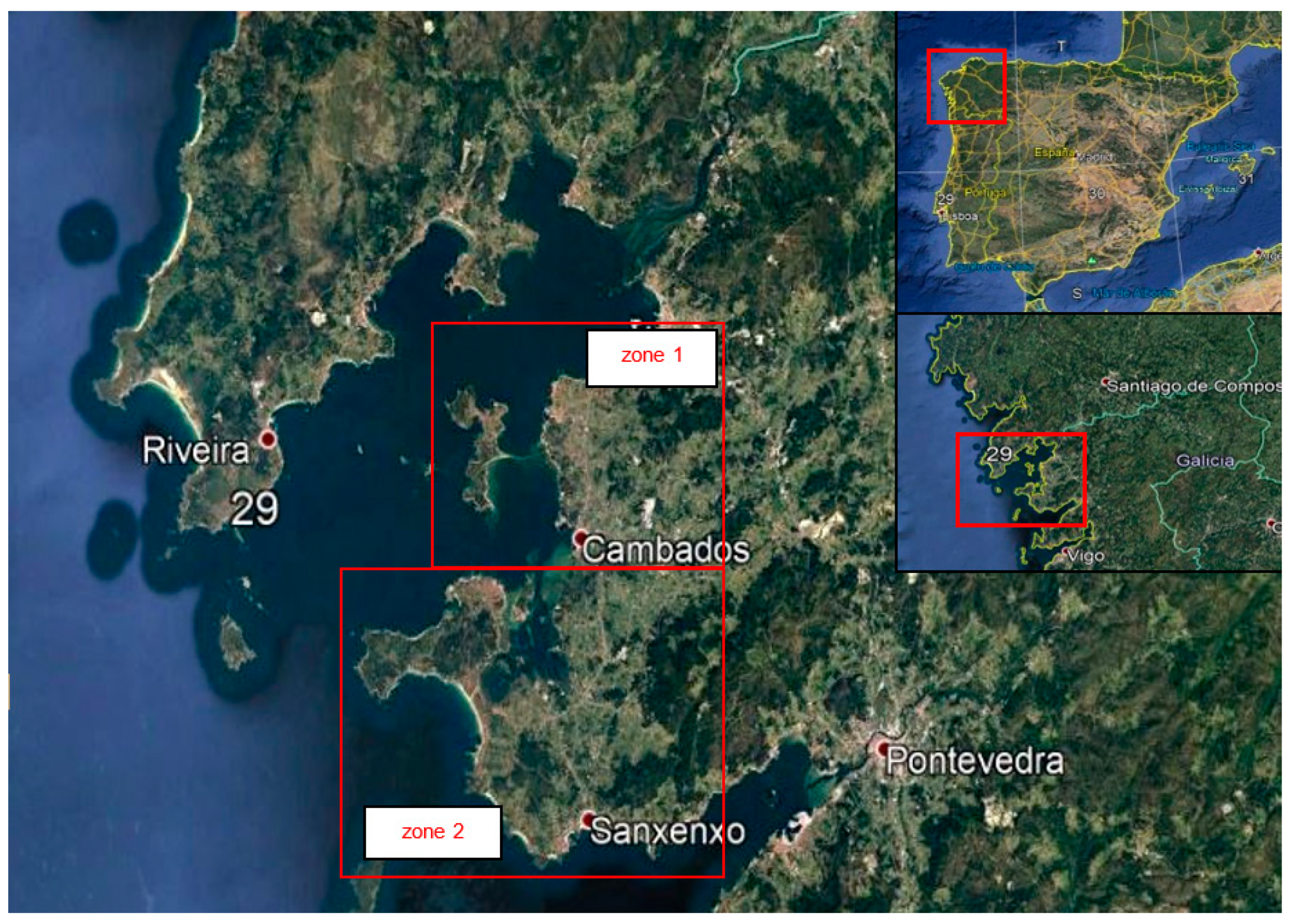
Figure 1. Location of the study areas: Isla de Arosa-Villanueva-Cambados (1) and Sierra de Grove-Castrove-Sangenjo (2).
Land 12 01068 g001
Figure 2. Geological map of the Arosa estuary.
Land 12 01068 g002
Figure 3. Geomorphological map of the Arosa estuary.
Land 12 01068 g003
Figure 4. Location of the geosites in the study area.
Land 12 01068 g004
Figure 5. Fault plane (PF) with striations and direction N 160° E, positions of the fossil beach of the last interglacial (U.I.) and the distribution of colluvium in both blocks.
Land 12 01068 g005
Figure 6. Diagram with the dune sequences (D-1, D-2 and D-3) and normal fracture N 160° E.
Land 12 01068 g006
Figure 7. Palaeobeach of the last interglacial in Punta Moltalvo (1). Dark-colored conglomerates from the paleobeach (2). Normal failure plane (3). Cemented fossil beach at Foxos Beach (4,5). Contact of the Caldas de Reyes granite with the metamorphic rocks of Foxos Beach (6). Notches with the dune sequences (D-1, D-2 and D-3) and normal fracture N 160° E (7,8).
Land 12 01068 g007
Figure 8. Distribution of sea beds on the study coastline.
Land 12 01068 g008
Figure 9. Tombolo of Lanzada and the Umia-O Grove Intertidal Complex (1). Umia-O Grove Intertidal Complex with a border of salt marshes (2). View of the Tombolo de La Lanzada and the cavalry stones (3,4) from Mount Xiradella on the Grove peninsula.
Land 12 01068 g009
Figure 10. Diagram of the morphology of the pias and taphonis (1). Rock block with tafonis (2). gnamas (3). Gnama with drainage channel (4). Honeycomb-shaped taphonis (5).
Land 12 01068 g010
Figure 11. Arosa Island (1). Lighthouse on the Isla de Arosa where the intense orthogonal fracturing can be seen (2). Decompression fractures (3). Joint crossing by orthogonal fractures (4). Syenite Abrasion Platform (5).
Land 12 01068 g011
Figure 12. Capture of the itinerary through Stop 5 with the background geological map, elevation profile and photographs.
Land 12 01068 g012
Figure 13. Geosite “Isla de Arosa”, with an itinerary that includes the base of the geological map, descriptive text and most representative photos of each outcrop.
Land 12 01068 g013
Table 1. Weights for each parameter as a function of interest.
ParameterScientific InterestEducational InterestTourist/Recreational Interest
Representativeness (R)305---
Character type locality (T)105---
Degree of scientific knowledge of the location (K)15------
State of conservation (C)105---
Viewing conditions (O)1055
Rarity (A)155---
Geological diversity (D)1010---
Learning objectives/educational use (Cdd)---20---
Logistics infrastructure (Il)---155
Population density (Dp)---55
Accessibility (Ac)---1510
Intrinsic fragility (E)------15
Association with elements natural and/or cultural (NH)---55
Beauty or spectacularity (B)---520
Informative content/use (Cdv)------15
Potential for tourism/recreation activities (Ptr)------5
Proximity to recreational areas (Zr)------5
Socioeconomic environment (Es)------10
TOTAL100100100
Table 2. Weights for each parameter for geosites.
S1S2S3S4S5S6S7
Representativeness2222222
Character type locality1111111
Degree of scientific knowledge about the place4422222
State of conservation2222224
Viewing conditions4444424
Rarity0022002
Geological diversity4420024
Learning objectives/educational use2222222
Logistics infrastructure4444444
Population density2222222
Accessibility1004422
Intrinsic fragility1101441
Association with elements of nature/culture heritage4444444
Beauty or spectacularity1110111
Informative content/use2222222
Potential for activities tourism/recreation1222211
Proximity to recreational areas4444444
Socioeconomic environment1111111
Total36373739413843
Table 3. Weighted values of the geosites according to their scientific, educational and touristic values.
S1S2S3S4S5S6S7
Scientific interest (Vc)230230210160160160200
Educational interest (Vd)235225210220240230245
Tourist/recreational interest (Vt)180175160195260225190
Total565630580575660615635
Vc = value out 105.85.85.34.04.04.05.0
Vd = value out 105.95.65.35.56.05.86.1
Vt = value out 104.54.44.04.96.55.64.8
Vc = algorithm95959074747484
Vd = algorithm66635963656468
Vt = algorithm44423642696246
Table 4. Weighted values of the geosites according to conservation status: susceptibility and risk of degradation.
S1S2S3S4S5S6S7
Geosite size factor (EF)0.0150.0080.0150.0080.0030.0030.003
Fragility (F)52010520105
Natural threats (AN)1020102020110
Degradation susceptibility (SDN)0.753.001.50.751.000.030.13
Interest for mining or water exploitation (VuM)0000204
Vulnerability to plunder (VuEX)0100000
Proximity to activities and infrastructures (VuI)1111124
Accessibility (Ac)1011414
Protection regime(P)4444144
Physical or indirect protection (PF)4444444
Land ownership and access regime (TS)4444444
Population density (DP)2222222
Proximity to recreational areas (ZR)4444444
Anthropic degradation susceptibility (SDA)1.730.981.730.860.450.330.73
Degradation Risk (RDNC)0.4351.740.7950.30.40.010.06
Degradation Risk (RDND)0.44251.680.7950.4120.60.01450.076
Degradation Risk (RDNT)0.3371.320.60.3670.650.0140.06
Degradation Risk (RDAC)1.0000.56550.9140.3450.180.130.348
Degradation Risk (RDAD)1.0170.5460.9140.4740.270.1880.442
Degradation Risk (RDAT)0.7760.4290.690.4220.29250.1820.348
Disclaimer/Publisher’s Note: The statements, opinions and data contained in all publications are solely those of the individual author(s) and contributor(s) and not of MDPI and/or the editor(s). MDPI and/or the editor(s) disclaim responsibility for any injury to people or property resulting from any ideas, methods, instructions or products referred to in the content.