Article

Scenario Analysis for Resilient Urban Green Infrastructure

1
School of Architecture and Art, Central South University, Changsha 410083, China
2
Faculty of Architecture and the Built Environment, Delft University of Technology, 2628 BL Delft, The Netherlands
3
Institute of Spatial Management, Wrocław University of Environmental and Life Sciences, 50-357 Wrocław, Poland
*
Author to whom correspondence should be addressed.
Land 2022, 11(9), 1481; https://doi.org/10.3390/land11091481
Submission received: 29 July 2022 / Revised: 30 August 2022 / Accepted: 1 September 2022 / Published: 4 September 2022

Abstract

:
With the advancement of urbanization, the stress on the green infrastructure around the urban agglomeration has intensified, which causes severe ecological problems. The uncertainty of urban growth makes it difficult to achieve effective protection only by setting protection red lines and other rigid measures. It is of practical significance to optimize the resilience of the stressed green infrastructure. To this end, we explore a scenario simulation analysis method for the resilience management of green infrastructure under stress. This research applies artificial neural network cellular automata to simulate the impacts of the Chang-Zhu-Tan urban agglomeration expansion on the green infrastructure in 2030 in three scenarios: no planning control, urban planning control, and ecological protection planning control. Based on the analysis, we identify four green infrastructure areas under stress and formulate resilience management measures, respectively. The results show that: (1) The distribution pattern of green infrastructure under stress is different in three scenarios. Even in the scenario of ecological protection planning and control, urban growth can easily break through the ecological protection boundary; (2) Residential, industrial, and traffic facility land are the main types of urban land causing green infrastructure stress, while forest, shrub, and wetland are the main types of the stressed green infrastructure; (3) Efficient protection of green infrastructure and the management of the urban growth boundary should be promoted by resilient management measures such as urban planning adjustment, regulatory detailed planning, development strength control and setting up the ecological protection facilities for the stressed green infrastructure areas of the planning scenarios and the no-planning control scenarios, for the areas to be occupied by urban land, and for the important ecological corridors. The results of this study provide an empirical foundation for formulating policies and the methods of this study can be applied to urban ecological planning and green infrastructure management practice in other areas as well.

1. Introduction

According to the data from the seventh census of China and the national population development plan, the urbanization rate of Chinese permanent residents has reached 63.89% in 2020 and will rise to 70% in 2030, while the figure was only 36.09% in 2000. Each 1% increase in China’s urbanization rate requires 3459 km2 of construction land [1]. Urban agglomerations, as the key receiving areas for the urbanized population, are expanding faster than independent cities in general, and therefore, the green infrastructure around them will be under more serious stress. Green infrastructure refers to the natural ecosystem with important ecological value, including green space such as forest and grassland, and blue space such as wetland and water systems, designed and managed to deliver different kinds of ecosystem services [2,3,4]. The green infrastructure of urban agglomerations not only has various functions such as maintaining regional biodiversity, regulating climate, providing recreational services, and guaranteeing water supply, but also plays an important role in promoting urban transformation and enhancing urban development dynamics [5,6,7,8]. Because of the need for construction land in the urbanization process, the green infrastructure of urban agglomerations is often more vulnerable to stress [9,10]. The green infrastructure of three major urban agglomerations in China—Yangtze River Delta, Pearl River Delta, and Beijing-Tianjin-Hebei—decreased by 951 km2, 97 km2, and 212 km2, respectively, from 1992 to 2010 [11]. In this regard, China’s territorial spatial planning system puts forward the spatial control requirements of “three zones and three lines”, which sets the urban development boundary, permanent basic agricultural land, and ecological protection red lines. However, such boundaries do not specify rigid space and flexible space. Therefore, it is of great practical significance to understand the dynamics of green infrastructure of urban agglomerations, and to protect the original function of green infrastructure while meeting the development of urban agglomerations with empirical analysis.
Green infrastructure management can be divided into two categories. One is focused on meeting urban development, mainly through the method of cellular automata simulation to delineate the urban-growth boundary (UGB), and the construction of green infrastructure outside the boundary is prohibited, as represented by Beijing, Huizhou, and other cities [12,13]. The other category takes green infrastructure protection as the starting point and delineates the green infrastructure protection boundary mainly through the evaluation results of ecological suitability, with Wuhan, Chengdu, and other cities as representatives [14].
Although the two management methods have different focuses, they both implement static rigid control of green infrastructure. While both cities and green infrastructure are complex network systems that are constantly changing dynamically, traditional static and rigid control measures can hardly solve the complex contradictory problems between urban development and green infrastructure protection [15,16]. This has led to the breakthrough of the red line of green infrastructure control. The core green infrastructure is difficult to hold, and different types of ecological protection red lines have been broken one after another.
A resilient urban green infrastructure can help to solve the problem of urban growth stressing green infrastructure, because of its adaption to a constantly changing environment dynamically. Resilience as a term was used by physicist Thomas Young in 1807 to describe elastic deformation in the context of materials science. While the traditional concept of resilience in ecology was used to describe the persistence of natural systems in response to changes in external elements and human factors, the concept of resilience has evolved to focus on “transformational capacity”, i.e., the ability of ecosystems to change, adapt, and change in response to pressures and constraints. Ecological resilience, on the other hand, emphasizes the amount of disturbance that an ecosystem can withstand without changing its self-organizing processes and structure, and refers to the degree to which an ecosystem can adapt to change in the face of external pressures and before reforming a stable structural system [17]. The main purpose of optimizing the resilience of green infrastructure is to enhance the ability of green infrastructure to resist disturbances, cope with changes and adapt to changes through relevant control measures and strategies to achieve the harmonious development of urban-ecological systems [18].
Research on ecological resilience has focused on ecosystem resilience evaluation and construction [19,20,21], ecological resilience optimization [22,23], and the role of ecological resilience [24]. In China, the research on ecological resilience is still in its infancy, and the relevant studies mainly focus on the application [25,26] and the theory of ecological resilience [27] in the ecological design of resilience, and there is a relative lack of research on the optimization of ecosystem resilience. Ecological resilience has an important impact on improving the self-organization capacity of urban ecosystems [28] and plays an important role in promoting the coordination of multiple objectives between the complex systems of urban development and green infrastructure protection [15]. While studies on green infrastructure optimization do exist, they mainly focus on ecological spatial structure [29,30], governance control measures [31,32], and spatial networks [33,34]. There is a relative lack of research on optimization and guiding control strategies for rapidly developing urbanized areas, especially in the study of ecological spatial toughness control and optimization of urban agglomerations [35].
Moreover, the development process between urban growth and green infrastructure protection is less considered, and the relevant optimization measures are still for the improvement of static rigid control measures. Green infrastructure protection and urban growth are the results of the joint action of self-organization and other organizations [36], and the traditional research methods are unable to identify the dynamic diffusion process of the two types of space. Regarding this issue, the minimum cumulative resistance model (MCR) can well reflect the intrinsic linkage process of ecological processes [37], and the self-organizing kernel embedded in the cellular automata model (CA model) can simulate the spatio-temporal evolution process of urban expansion [38]. Additionally, both of these methods are widely applied in this field.
To summarize, the current rapid urban development in China has imposed great stress on green infrastructure which is essential for biodiversity, and the existing controlling measures have problems coping with the dynamic urban space and green infrastructure change process. Resilient control measures are desired to protect green infrastructure under uncertainty. Therefore, this research aims to formulate resilient strategies for the green infrastructure stressed by uncertain urban growth.
More specifically, to achieve this, the following research questions will be answered:
  • How can the dynamic urban growth stressing green infrastructure under uncertainty be presented?
  • What are the stressed areas of the green infrastructure and their characteristics accordingly?
  • What are the resilient strategies for the identified stressed green infrastructure based on their characteristics?

2. Context and Data

2.1. Context

Chang-Zhu-Tan urban agglomeration is located in the central-eastern part of Hunan Province, including Changsha, Zhuzhou, and Xiangtan cities, which are distributed in the shape of a triangle along Xiangjiang River, with less than 20 km between them. With the development of the urban agglomeration, the green infrastructure of Chang-Zhu-Tan urban agglomeration is seriously reduced [39,40], among which the area of important green infrastructure is reduced by construction land in Muyun town from 2004 to 2010 by 427.67 hm2 [41]. At this stage, Changsha-Zhuzhou-Tan urban agglomeration is facing the development of urban integration. The pressure of green infrastructure around the urban agglomeration is further highlighted. Based on a collection of remote sensing images data, this study covers the main administrative areas of Changsha, Zhuzhou, and Xiangtan cities with a total area of 22,104.4 km2, including most of the districts and counties under the jurisdiction of Changsha, Zhuzhou, and Xiangtan cities, but excluding a few areas such as Ningxiang City, Shaoshan City, the western part of Xiangxiang City, and Yanling County (Figure 1).

2.2. Data Sources

The data used include the following: 30 m resolution satellite image data, DEM data, and vegetation cover data of Chang-Zhu-Tan Urban agglomeration in 1999, 2008, and 2018 (source: Geospatial Data Cloud, http://www.gscloud.cn/ (accessed on 8 July 2020)), the Chang-Zhu-Tan Urban agglomeration Regional Plan (2008–2020) (adjusted in 2014) [42], the Master Plan of Ecological Green Heart Area of Chang-Zhu-Tan Urban agglomeration (2010–2030) (revised in 2018) [43], the Changsha City Urban Master Plan (2003–2020) (revised in 2014) [44], the Xiangtan City Urban Master Plan (2010–2020) (revised in 2017) [45], and the Zhuzhou City Urban Master Plan (2006–2020) (revised in 2017) [46]. Among them, the satellite image data of Chang-Zhu-Tan urban agglomeration in 1999, 2008, and 2018 were classified into arable land, forest land, grassland, water area, construction land, and unused land by using Erdas Imagine supervised interpretation function [47,48,49]. Additionally, the color difference of the surface coverage patches shown in different areas is combined with the Erdas Imagine classification to determine the main landmark elements of the geographical areas. The decoded data from the three years are then used to compare with satellite images using visual corrections to obtain the land-use data of the Chang-Zhu-Tan urban agglomeration. To reduce the number of operations, the final relevant land-use data are obtained by resampling in 100 m units with the GIS nearest neighbor assignment.

3. Methods

This research follows the following steps: Firstly, the green infrastructure of Chang-Zhu-Tan urban agglomeration is identified by using the principles of landscape ecology. Additionally, then the Cellular Automata (CA) model is used to simulate the green infrastructure in different control measure scenarios. Finally, the characteristics of the green infrastructure under stress are analyzed and the relevant resilience control and development strategies are formulated. The relevant methodological flow is shown in Figure 2.

3.1. Integrated Green Infrastructure of Urban Agglomeration Identification and Extraction

The green infrastructure range identification of the Chang-Zhu-Tan urban agglomeration should be integrated with the principle of landscape ecological security patterns [39,50]. Firstly, three representative indicator species representing the main environment characteristics of the study area are selected, i.e., Chinese pool heron, red-billed leiothrix, and Siberian weasel, representing medium pheasants living in the wetland ecosystem, small pheasants living in the forest ecosystem, and mammals inhabiting in multiple ecosystems, respectively. They are used to identify the green infrastructure and species migration ecological corridors that have important values for species survival and reproduction [51]. Secondly, key habitats of indicator species need to be identified as green infrastructure of significant value. Thirdly, the minimal cumulative resistance (MCR) model is used to simulate the process of the indicator species overcoming spatial resistance to spread out from the habitat, and the core habitat space range of different species is used as the “source” to identify the biological migration corridor between different ecological patches [52,53,54]. Fourthly, the migration corridors of different species are superimposed. Additionally, the multi-species migration corridors are treated as primary corridors with a width of 200 m, considering the conservation of biodiversity [55]. Finally, the whole green infrastructure range can be obtained by integrating the habitat and ecological corridor. As a result, the ecological spatial context of the Chang-Zhu-Tan urban agglomeration is obtained comprehensively.
The formula used is:
M C R = f ( D i j × R i )
where MCR is the minimum cumulative resistance value, which reflects the minimum cost of indicator species in the process of moving from source to destination; f is a positive correlation function characterizing the relative accessibility of a path from a source patch to a point in space; Dij is the spatial distance of the landscape basal plane i traversed by a species from source patch j to a point in space; and R i   is the relative resistance coefficient of indicator species (Table 1).

3.2. Simulation of Urban Growth in Different Scenarios

The impacts of the urban growth of the Chang-Zhu-Tan urban agglomeration on the green infrastructure are simulated with the artificial neural network cellular automata model in the open source software “Geographic Simulation and Optimization System” (GeoSOS) [68]. This method is used to simulate the self-organized growth process of urban construction land expansion in a bottom-up manner and visualize the impact of urban growth on green infrastructure [69]. Additionally, this approach’s biggest advantage is that the model information can be obtained by training the neural network, which is especially suitable for research in the field of complex systems [70], and the used detailed formula is as follows:
P d , i j t = ( 1 + ( 1 n γ ) α ) × j w j , i 1 1 + e n e t j ( k , t )
where P d , i j t is the probability of a cell being developed, γ is a random number between 0 and 1, the value of α ranges from 1 to 10, neti(k,t) is the signal received by the jth neuron of the hidden layer, and wj,l is the weight between the hidden layer and the output layer [71]. The convertibility between different land uses is shown in Table 2, where 1 represents convertibility and 0 represents non-convertibility.
The spatial variables of the urban growth model are set with the 30 m resolution data of 2018 [72,73,74,75,76,77] (Table 3). All the influencing factors are normalized; this is the input into the artificial neural network CA model in GeoSOS as the parameter affecting the probability of land conversion, to simulate the urban growth in the year 2018 based on the urban growth law from the year 1999 to the year 2008. Additionally, after calibration, the simulated results are compared with the actual maps in 2018. In the simulation setting, α equals 5 and the conversion threshold is taken as 0.8 [78]. The validation results show that the overall accuracy of the model is 90.87% and the Kappa coefficient is 0.82, which is higher than the normally applied 0.8 [77]. Therefore, this calibrated model is used as the basis to simulate the expansion of Chang-Zhu-Tan urban agglomeration in the year 2030 with different control measures to understand the stress imposed on green infrastructure.
The spatial expansion of urban growth is a self-organizing process, but other organizational factors such as different development policies and control strategies can have a significant impact on the development of urban agglomerations [79]. In terms of the driving factors of other organizations affecting urban growth mainly urban planning and ecological protection planning have been included, we have analyzed the main influencing factors on the development of urban agglomerations in China and determined three scenarios of green infrastructure stress in Chang-Zhu-Tan urban agglomeration with different control measures, namely, “no planning control”, under control of urban planning, and ecological protection planning control. The “no planning control” scenario measure does not equal to the absence of control measures, but the simulation of urban growth with the original development pattern of urban agglomerations without new planning control measures. The second scenario is based on ongoing urban planning to predict future urban spatial development. According to urban planning, different conversion coefficients are assigned to land use, including urban comprehensive function area (1), urban new town group, high-tech group of science and education (3), industrial park (5), other non-urban land function areas (7), the ecological green heart protection area of urban agglomeration (9), and normalized processing is carried out [42]. The third scenario is to take the existing green infrastructure as the protection area of ecological planning and simulate its future situation under the stress of urban construction land. The conversion coefficient of green infrastructure is assigned 3, and the non-green infrastructure is assigned 7 [80].

3.3. Stressed Green Infrastructure Identification

By superposition analysis of the spatial changes of Chang-Zhu-Tan urban agglomeration in 2030 in three scenarios, the conflict areas between urban growth and green infrastructure in different scenarios are obtained, namely the stressed areas of the green infrastructure of urban agglomeration. This serves as the area for further analysis.

3.4. Green Infrastructure Stress Characteristics and Resilience Measures

By superimposing and analyzing the green infrastructure under stress in different areas, we have classified the areas into three categories based on degrees of stress on green infrastructure: first, the part of green infrastructure that will not be affected by urban growth in the three scenarios can be divided into the safety zone of green infrastructure; second, the green infrastructure affected by urban growth in two or one of the scenarios is under the stress of uncertainty, which requires the adoption of compatible and flexible management and control measures; third, in the three scenarios, the part of the green infrastructure to be occupied by urban growth will face the greatest pressure from urbanization. The development control measures, taking into account both ecological functions and construction land functions, should be considered. Therefore, the second and third parts of green infrastructure are threatened by urban growth and need to be included in key management zones.
In terms of the main driving force of urban expansion, self-organization growth, and other-organization planning, an ecological corridor plays an important role in maintaining regional green infrastructure [81,82,83]. The key management zones of green infrastructure are divided into the following categories (Table 4): (1) external factors that cause changed green infrastructure with urban planning control and the ecological protection planning control scenario; these spaces are further divided into stress zones with the urban planning control alone, with ecological protection planning control alone and joint stress zones of both; (2) the no planning control self-organizational model developed stressed green infrastructure, and the area affected by it alone are together classified as the stress zones in the no planning control, excluding the areas of the next type; (3) in all the three scenarios, the part of green infrastructure under the stress of urban growth are the zones that will soon be occupied by urban development land; (4) the biological migration corridor affected by urban growth is classified as the stress zones of the core ecological corridor.
The stress zones of green infrastructure may be invaded by urban growth, and there is great uncertainty in future development and construction, so resilience optimization measures need to be formulated. To do so, we firstly analyze the causes of stress in different areas and then the planning and control measures accordingly, such as adjustment of planning, replacement of land, and control of development intensity are advised, in order to enhance the ability of green infrastructure to adapt to the change [18,84,85]. On the other hand, the zones that will soon be occupied by urban development land are the key areas for future construction activities; control and guidance strategies can be formulated according to the compatibility of different development land types to different habitats [25,86,87,88] (Table 4).

4. Results

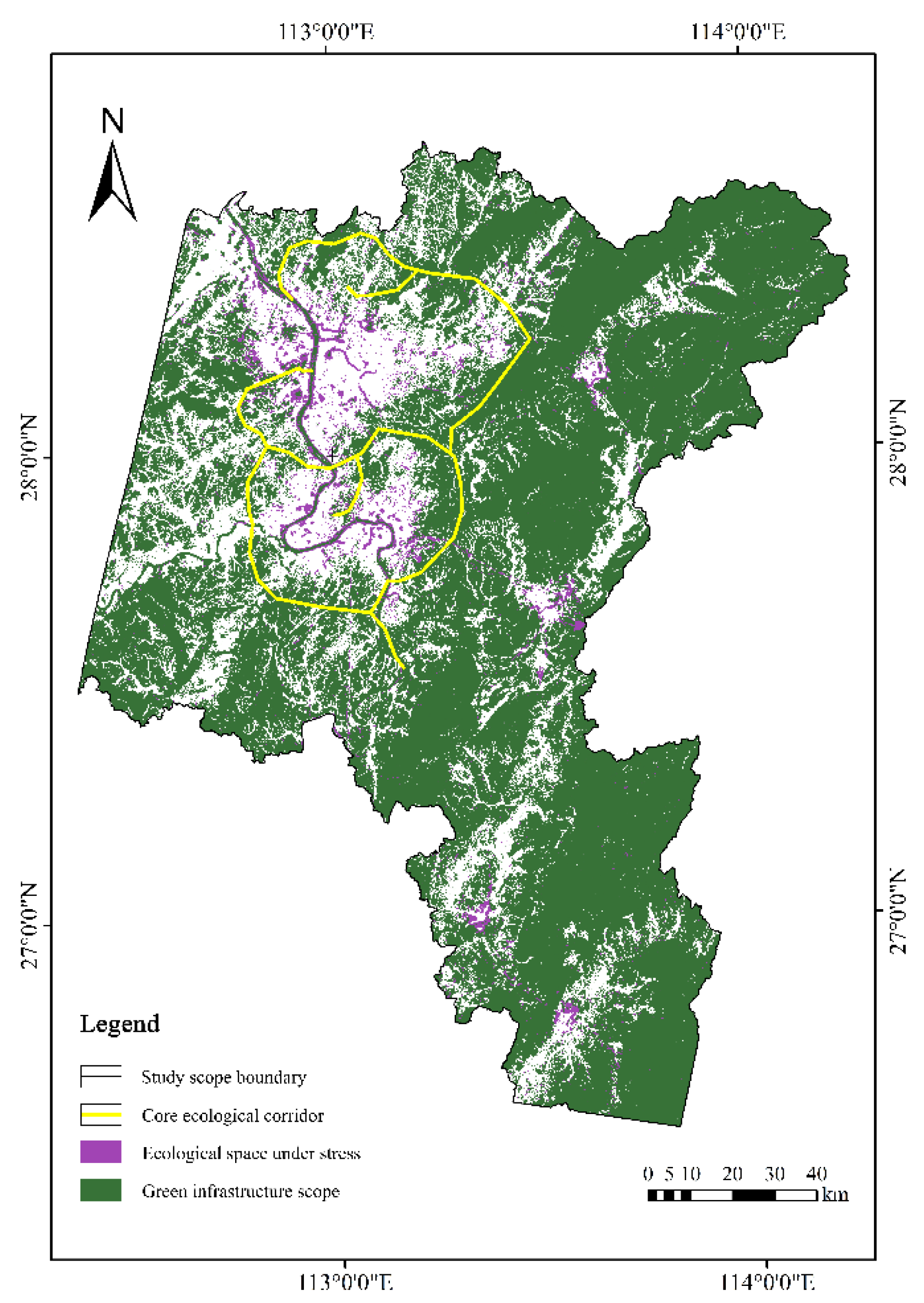
4.1. Green Infrastructure and Corridor in the Chang-Zhu-Tan Urban Agglomeration

The green infrastructure of the Chang-Zhu-Tan urban agglomeration is obtained by identifying the main habitats of different species and superimposing them together (Figure 3). The green infrastructure of the Chang-Zhu-Tan urban agglomeration has a total area of 15,690.19 km2, which is mainly concentrated in the western and eastern parts of the Changsha built-up area, the northwestern and southern parts of the Xiangtan built-up area, and the eastern and northern parts of the Zhuzhou built-up area. The length of primary corridors is 363.19 km long and areas are 143.56 km2, and they are mainly concentrated in the peripheral area of the built-up area of the urban agglomeration and the southern part of Changsha city, the northern part of Xiangtan city, and the southern part of Zhuzhou city.

4.2. Stressed Green Infrastructure Analysis in Different Scenarios

4.2.1. Stressed Green Infrastructure Characteristics

The simulation results show the patterns of the stressed green infrastructure in the “no planning control” scenario (Figure 4), the stressed green infrastructure in the urban planning control scenario (Figure 5), and the stressed green infrastructure in the ecological protection planning control scenario (Figure 6). The details of the stressed area and their characteristics are shown in Table 5.
The analysis of green infrastructure under stress in the three scenarios shows that the stressed zone of green infrastructure is the smallest in the ecological protection planning control scenario, the second largest in the “no planning control” scenario, and the largest in the urban planning control scenario. This indicates that when the construction is carried out according to urban planning, the surrounding green infrastructure is under greater pressure and the green infrastructure is more affected. Meanwhile, by analyzing the characteristics of the stressed areas, we find that the green infrastructure in the southwest of Changsha City, the north and east of Xiangtan City, and the north and west of Zhuzhou City are under greater pressure in the three scenarios, which also coincides with the development direction of the city integration and urban agglomeration development strategy of the Changsha-Zhuzhou-Tan urban agglomeration. The western area of Changsha City, as the key construction area of Xiangjiang New District, has stressed green infrastructure in all three scenarios. However, the stressed area in the northern part of Changsha City in the urban planning control scenario is significantly larger than that in the other two scenarios, which is also related to the fact that the northern part of Changsha City is considered the key development area in the urban general planning. Notably, this analysis proves that the planning and control as “other-organized” measures can only affect urban growth to a certain extent, but cannot fundamentally change the urban “self-organized” growth process. Secondly, the three scenarios have different impacts on the local green infrastructure, indicating that there are areas of the green infrastructure under uncertain urbanization stress, which are the areas for resilient green infrastructure control.

4.2.2. Identification of the Control Area of the Green Infrastructure

A comprehensive analysis of the stressed green infrastructure reveals that in the three scenarios, the safety zone of green infrastructure, which is not affected by urban growth, accounts for 98% of the total green infrastructure, while the total stressed zone of green infrastructure is only 269.86 km2 (Table 6 and Figure 7).

4.3. Resilient Strategies for the Identified Key Green Infrastructure Control Areas

4.3.1. Identification of Key Green Infrastructure Control Area

By overlaying the stressed green infrastructure patterns and urban land-use planning maps in different scenarios in GIS, four detailed types of key ecological control spaces are identified. The detailed information is shown in Table 7.

4.3.2. Resilience Management Strategies of the Stressed Green Infrastructure

The protection measures in Table 4 are applied to the stressed green infrastructure in the empirical case, and resilience management strategies are formulated according to the stress characteristics of the four key control areas of green infrastructure (Table 8).

5. Discussions

The research on urban growth and ecological resilience focuses on the representation of their feature of coupling relations [25,28,32,35] but there is a lack of comprehensive analysis in the context of urban growth uncertainty. Both cities and green infrastructure are complex network systems that are constantly changing, and traditional static and rigid control measures can hardly solve the complex contradictory problems between urban development and green infrastructure protection [15,16]. Uncertainty exists in organizational drivers, such as planning policies and their implementation, leading to different future patterns of urban growth. Therefore, this study proposes a scenario-analysis approach by combining the minimum cumulative resistance model (MCR) with cellular automata (CA) to reflect the intrinsic dynamic linkage process of ecological processes under uncertainties [37,38]. Based on our simulation results, urban land expansion in urban agglomeration is a self-organizing growth process under the influence of organizational planning measures which are also consistent with other studies [17,28,36]. The distribution pattern of green infrastructure under stress is different in three scenarios. Even in the scenario of ecological protection planning and control, urban growth can easily break through the ecological protection boundary. The applied artificial neural network CA model can be used to predict the uncertain future of urban growth scenarios, and it could be more conducive to solving the practical problems that may be faced by the stressed green infrastructure [89,90].
Furthermore, most of the existing studies on the ecosystem resilience assessment and management are limited to the evaluation and improvement of indicators [20,22,23,24] and ignore the difference in the diversification pattern caused by the spatial game of the future urban growth. The validation and calibration process and results confirmed our hypotheses that the process of urban growth stressing green infrastructure in various scenarios could be simulated and the stressed green infrastructure could be identified with different characteristics. Residential, industrial, and traffic facility land are the main types of urban land causing green infrastructure stress, while forest, shrub, and wetland are the main types of the stressed green infrastructure in our case. The green infrastructure stressed by urban growth is mainly concentrated around the urban built-up area, but the distribution pattern of the stressed green infrastructure varies with different scenarios. This is because the driving factors of urban self-organization determine the main trend of urban growth. For instance, the urban population of Chang-Zhu-Tan urban agglomeration is about 10.2 million in 2020, and it will rise to 14 million in 2030 as compared. Even in the scenario of ecological protection planning control, urban land use is easy to break through the protection boundary. The identification of stressed green infrastructure in various scenarios and the detailed analysis of their characteristics help identify the diversities and form resilience optimization measures for the stressed green infrastructure afterwards.
The importance of resilience for the green infrastructure has been discussed in the case study of Detroit in America [91] and in the review on relative research of America and Europe [92] but still in its infancy in China. The analysis results have proved clearly the hypothesis that the current rigid measures cannot cope with the dynamic, complex, changing processes of urban land use and green infrastructure, which, on the other hand, confirms that resilient measures are needed to improve the green infrastructure resilience for urban agglomerations in China. In contrast with the more frequent design proposals for green infrastructure protection, which almost exclusively gives static and rigid conservation boundaries, our approach provides alternatives for changing the landscape of urban agglomeration with more resilience. The in-depth analysis proposes that the resilience of green infrastructure could be achieved by resilient management measures, such as urban planning adjustment, regulatory detailed planning, development strength control, and setting up the ecological protection facilities for the stressed green infrastructure.
To summarize, this study has successfully formulated an effective methodology that provides a scenario analysis approach to identify the stressed ecological spatial patterns and form resilient measures for urban agglomerations in China. We comprehensively analyze the dynamic game process of the urban growth stress green infrastructure and identify the different types of stressed green infrastructure. This approach helps formulate efficient green infrastructure resilience control strategies according to the uncertainty of urban growth, ensuring that stressed ecosystems can resist disturbance, respond, and adapt to changes in different scenarios.
Nevertheless, this study has some limitations. The application of the resilience concept in green infrastructure is still in the exploration stage, and the future of urban growth under the influence of multiple driving forces is more complex than the scenario hypothesis in this research. The research on the stress impacts and resilience response of different urban land-use types on different green infrastructure needs to be further studied.

6. Conclusions

The resilience optimization of green infrastructure in rapidly developing urbanized areas, as a key yet difficult point in the ecological construction of urban agglomerations, has not received sufficient attention in relevant studies. The uncertainty of urban growth leads to the uncertainty of urban agglomeration green infrastructure. As it is difficult to adapt to such uncertainty, the previous planning measures for green infrastructure protection based on the demarcation of rigid protection red lines are easy to fail. To solve this problem, we have proposed a scenario simulation analysis method to identify the types of stressed green infrastructure and conduct resilience management based on the characteristics of self-organization growth of urban land and other-organization growth of urban planning. In this method, the cellular automata model of urban growth has been constructed by using an artificial neural network, and four types of green infrastructure under urban growth stress have been identified in three scenarios. Resilience management strategies have been proposed to adapt to the alternative futures of urban growth in detail based on land-use types.
Currently, China is still in a period of rapid urbanization, and the research on the optimization of the resilience of the stressed green infrastructure not only helps to solve the conflicts between urban expansion and ecological protection but also contributes to the construction of an ecological city. Through the study on the optimization of the resilience of the stressed green infrastructure of Chang-Zhu-Tan urban agglomeration, it is found that the strong urban self-organizing driving force dominates the future urban growth process, while the other organizing driving force of planning affects the future urban growth pattern to a certain extent. Although the protection planning of green infrastructure has a certain constraint effect on urban growth, its protection boundary is easily breached by urban land use. The identification of four types of stressed spaces in Chang-Zhu-Tan urban agglomeration and their resilience management is beneficial to improving the conservation efficiency of green infrastructure and the management efficiency of the urban-growth boundary by targeting the most suitable measures for the spaces with resilient potentials.

Author Contributions

Conceptualization, B.L. and T.W.; methodology, X.H.; formal analysis, X.H.; resources, T.W. and B.L.; writing—original draft preparation, Y.W., B.L., T.W. and J.K.K.; writing—review and editing, B.L., Y.W., T.W. and J.K.K.; visualization, X.H. and Y.W.; supervision, B.L. and T.W.; funding acquisition, T.W. and J.K.K. All authors have read and agreed to the published version of the manuscript.

Funding

This research was supported by the Hunan Province Philosophy and Social Science Foundation of China (09yba158). And the article processing costs are waived.

Institutional Review Board Statement

Not applicable.

Informed Consent Statement

Not applicable.

Data Availability Statement

Not applicable.

Acknowledgments

The authors would like to thank the reviewers for their valuable comments and suggestions.

Conflicts of Interest

The authors declare no conflict of interest.

References

  1. National Bureau of Statistics of China. Degree of Urbanization in China from 1980 to 2021; National Bureau of Statistics: Beijing, China, 2022.
  2. Brzoska, P.; Spage, A. From City- to Site-Dimension: Assessing the Urban Ecosystem Services of Different Types of Green Infrastructure. Land 2020, 9, 150. [Google Scholar] [CrossRef]
  3. Chatzimentor, A.; Apostolopoulou, E.; Mazaris, A.D. A review of green infrastructure research in Europe: Challenges and opportunities. Landsc. Urban Plan. 2020, 198, 103775. [Google Scholar] [CrossRef]
  4. Monteiro, R.; Ferreira, J.C.; Antunes, P. Green Infrastructure Planning Principles: An Integrated Literature Review. Land 2020, 9, 525. [Google Scholar] [CrossRef]
  5. Chu, M.R.; Lu, J.Y.; Sun, D.Q. Influence of Urban Agglomeration Expansion on Fragmentation of Green Space: A Case Study of Beijing-Tianjin-Hebei Urban Agglomeration. Land 2022, 11, 275. [Google Scholar] [CrossRef]
  6. Shen, Z.; Wu, W.; Chen, M.; Tian, S.Q.; Wang, J. Linking Greenspace Ecological Networks Optimization into Urban Expansion Planning: Insights from China’s Total Built Land Control Policy. Land 2021, 10, 1046. [Google Scholar] [CrossRef]
  7. Yang, Y.Y.; Bao, W.K.; Li, Y.H.; Wang, Y.S.; Chen, Z.F. Land Use Transition and Its Eco-Environmental Effects in the Beijing-Tianjin-Hebei Urban Agglomeration: A Production-Living-Ecological Perspective. Land 2020, 9, 285. [Google Scholar] [CrossRef]
  8. Wang, Y.C.; Shen, J.K.; Xiang, W.N. Ecosystem service of green infrastructure for adaptation to urban growth: Function and configuration. Ecosyst. Health Sustain. 2018, 4, 132–143. [Google Scholar] [CrossRef]
  9. Colding, J.; Gren, A.; Barthel, S. The Incremental Demise of Urban Green Spaces. Land 2020, 9, 162. [Google Scholar] [CrossRef]
  10. Sarkar, A.; Chouhan, P. Dynamic simulation of urban expansion based on Cellular Automata and Markov Chain Model: A case study in Siliguri Metropolitan Area, West Bengal. Modeling Earth Syst. Environ. 2019, 5, 1723–1732. [Google Scholar] [CrossRef]
  11. Wang, C.; Ding, L. Regional characterization of environmental problems in urban agglomerations in the context of urban expansion. Acta Ecol. Sin. 2017, 37, 8058–8066. [Google Scholar] [CrossRef] [Green Version]
  12. Tang, Y.; Zhan, L. Delineation of Urban Development Boundary Based on Coupled Neural Network and Cellular Automata-Taking Huizhou City as an Example. Planners 2018, 34, 101–106. [Google Scholar]
  13. Liao, H.; Zhang, J.; Zhao, Z.; Cui, J. Tongzhou District, Beijing: A Study on the Delimitation Method of “Two Lines in One” of Urban Development Boundary and Ecological Red Line. Beijing Plan. Constr. 2019, 2, 88–91. [Google Scholar]
  14. He, M.; Wang, Y. Research on the Construction and Protection Countermeasures of Urban Ecological System in Wuhan. Planners 2009, 25, 30–34. [Google Scholar] [CrossRef]
  15. Bajc, K.; Stokman, A. Design for Resilience: Re-Connecting Communities and Environments. Landsc. Archit. Front. 2018, 6, 14–31. [Google Scholar] [CrossRef]
  16. Xiao, X.; Li, M.; Yuan, L. Sustainable Green Space System in High-density Cities-Based on the GI Theory. In Proceedings of the AASRI International Conference on Industrial Electronics and Applications (IEA), London, UK, 27–28 June 2015; pp. 575–579. [Google Scholar]
  17. Gunderson, L.H. Ecological resilience—In theory and application. Annu. Rev. Ecol. Syst. 2000, 31, 425–439. [Google Scholar] [CrossRef]
  18. Hong, W.Y.; Jiang, R.R.; Yang, C.Y.; Zhang, F.F.; Su, M.; Liao, Q. Establishing an ecological vulnerability assessment indicator system for spatial recognition and management of ecologically vulnerable areas in highly urbanized regions: A case study of Shenzhen, China. Ecol. Indic. 2016, 69, 540–547. [Google Scholar] [CrossRef]
  19. Ingrisch, J.; Bahn, M. Towards a Comparable Quantification of Resilience. Trends Ecol. Evol. 2018, 33, 251–259. [Google Scholar] [CrossRef]
  20. Sterk, M.; Gort, G.; Klimkowska, A.; van Ruijven, J.; van Teeffelen, A.J.A.; Wamelink, G.W.W. Assess ecosystem resilience: Linking response and effect traits to environmental variability. Ecol. Indic. 2013, 30, 21–27. [Google Scholar] [CrossRef]
  21. De Meulder, B.; Shannon, K. Designing Ecologies for Resilient Urbanisms. Landsc. Archit. Front. 2018, 6, 12–33. [Google Scholar] [CrossRef]
  22. Barnett, L.A.K.; Baskett, M.L. Marine reserves can enhance ecological resilience. Ecol. Lett. 2015, 18, 1301–1310. [Google Scholar] [CrossRef]
  23. Schippers, P.; van der Heide, C.M.; Koelewijn, H.P.; Schouten, M.A.H.; Smulders, R.; Cobben, M.M.P.; Sterk, M.; Vos, C.C.; Verboom, J. Landscape diversity enhances the resilience of populations, ecosystems and local economy in rural areas. Landsc. Ecol. 2015, 30, 193–202. [Google Scholar] [CrossRef]
  24. Mumby, P.J.; Chollett, I.; Bozec, Y.M.; Wolff, N.H. Ecological resilience, robustness and vulnerability: How do these concepts benefit ecosystem management? Curr. Opin. Environ. Sustain. 2014, 7, 22–27. [Google Scholar] [CrossRef]
  25. Wu, X.; Zhang, J.J.; Geng, X.L.; Wang, T.; Wang, K.; Liu, S.D. Increasing green infrastructure-based ecological resilience in urban systems: A perspective from locating ecological and disturbance sources in a resource-based city. Sustain. Cities Soc. 2020, 61, 102354. [Google Scholar] [CrossRef]
  26. Zhang, H.; Liang, X.Y.; Chen, H.; Shi, Q.Q. Spatio-temporal evolution of the social-ecological landscape resilience and management zoning in the loess hill and gully region of China. Environ. Dev. 2021, 39, 100616. [Google Scholar] [CrossRef]
  27. Liu, J.G.; Cui, W.H.; Tian, Z.; Jia, J.L. Theory of stepwise ecological restoration. Chin. Sci. Bull. Chin. 2021, 66, 1014–1025. [Google Scholar] [CrossRef]
  28. Pickett, S.T.A.; McGrath, B.; Cadenasso, M.L.; Felson, A.J. Ecological resilience and resilient cities. Build. Res. Inf. 2014, 42, 143–157. [Google Scholar] [CrossRef]
  29. Wei, S.M.; Pan, J.H.; Liu, X. Landscape ecological safety assessment and landscape pattern optimization in arid inland river basin: Take Ganzhou District as an example. Hum. Ecol. Risk Assess. 2020, 26, 782–806. [Google Scholar] [CrossRef]
  30. Fu, Y.J.; Shi, X.Y.; He, J.; Yuan, Y.; Qu, L.L. Identification and optimization strategy of county ecological security pattern: A case study in the Loess Plateau, China. Ecol. Indic. 2020, 112, 106030. [Google Scholar] [CrossRef]
  31. Li, S.N.; Zhao, X.Q.; Pu, J.W.; Miao, P.P.; Wang, Q.; Tan, K. Optimize and control territorial spatial functional areas to improve the ecological stability and total environment in karst areas of Southwest China. Land Use Policy 2021, 100, 104940. [Google Scholar] [CrossRef]
  32. Sun, C.Z.; Xu, S.; Qi, W.; Chen, C.; Deng, Y.; Pei, N.C.; Konig, H.J. Biodiversity constraint indicator establishment and its optimization for urban growth: Framework and application. Environ. Res. Lett. 2019, 14, 125006. [Google Scholar] [CrossRef]
  33. Cui, L.; Wang, J.; Sun, L.; Lv, C.D. Construction and optimization of green space ecological networks in urban fringe areas: A case study with the urban fringe area of Tongzhou district in Beijing. J. Clean. Prod. 2020, 276, 124266. [Google Scholar] [CrossRef]
  34. Shen, Q.-w.; Lin, M.-l.; Mo, H.-p.; Huang, Y.-b.; Hu, X.-y.; Wei, L.-w.; Zheng, Y.-s.; Lu, D.-f. Ecological network construction and optimization in Foshan City, China. Yingyong Shengtai Xuebao 2021, 32, 3288–3298. [Google Scholar] [CrossRef] [PubMed]
  35. Wang, S.J.; Cui, Z.T.; Lin, J.J.; Xie, J.Y.; Su, K. The coupling relationship between urbanization and ecological resilience in the Pearl River Delta. J. Geogr. Sci. 2022, 32, 44–64. [Google Scholar] [CrossRef]
  36. Cheng, K.; Chen, Y. Progress and review of urban self-organization studies at home and abroad. Urban Probl. 2006, 25, 21–27. [Google Scholar] [CrossRef]
  37. Yu, Q.; Yue, D.P.; Wang, J.P.; Zhang, Q.B.; Li, Y.T.; Yu, Y.; Chen, J.X.; Li, N. The optimization of urban ecological infrastructure network based on the changes of county landscape patterns: A typical case study of ecological fragile zone located at Deng Kou (Inner Mongolia). J. Clean. Prod. 2017, 163, S54–S67. [Google Scholar] [CrossRef]
  38. Lei, Z.K.; Feng, Y.J.; Tong, X.H.; Liu, S.; Gao, C.; Chen, S.R. A spatial error-based cellular automata approach to reproducing and projecting dynamic urban expansion. Geocarto Int. 2022, 37, 560–580. [Google Scholar] [CrossRef]
  39. Lu, X.; Li, N.; Li, Z. Research on the protection and utilization of urban and rural green infrastructures in urban cluster regions: An example of Changzhutan ecological green heart region. Urban Dev. Stud. 2013, 20, 82–87. [Google Scholar] [CrossRef]
  40. Tang, Y.; Zou, B.; Xu, S.; Chen, J.; Li, M. Analysis of anthropogenic disturbance processes in the ecological landscape of Changzhutan in the past 40 years. Geomat. Spat. Inf. Technol. 2017, 40, 74–79. [Google Scholar] [CrossRef]
  41. Tang, C.; Fan, J.; Chen, X. Research on the coordination of land use based on regional functions—Taking the ecological green heart of Changzhutan Muyun Town as an example. J. Nat. Resour. 2012, 27, 1645–1655. [Google Scholar] [CrossRef]
  42. Zhang, P.; Zhu, Y.; Shi, Y.; Hu, Y. Regional Planning of Chang-Zhu-Tan City Cluster (2008–2020) (Adjusted in 2014). Available online: http://fgw.hunan.gov.cn/xxgk_70899/ghjh/201605/t20160517_3058399.html (accessed on 8 July 2020).
  43. Hunan Provincial Department of Natural Resources. Master Plan of Ecological Green Heart Area of Changzhutan City Cluster (2010–2030) (Revised in 2018). Available online: http://zrzyt.hunan.gov.cn/zrzyt/xxgk/tzgg/201909/t20190926_10466709.html (accessed on 8 July 2020).
  44. Changsha Planning & Design Survey Research Institute. Changsha City Master Plan (2003–2020) (Revised in 2014). Available online: http://www.csgky.net/product/30.html (accessed on 8 July 2020).
  45. Xiangtan City Natural Resources and Planning Bureau. Xiangtan City Urban Master Plan (2010–2020) (Revised in 2017). Available online: http://zygh.xiangtan.gov.cn/10604/10606/17643/content_828376.html (accessed on 8 July 2020).
  46. Zhuzhou Municipal Commission of Development and Reform. Zhuzhou City Urban Master Plan (2006–2020) (Revised in 2017). Available online: http://fgw.zhuzhou.gov.cn/c14814/20190926/i984185.html (accessed on 8 July 2020).
  47. Dorgan, S. Image Processing and Data Analysis with ERDAS IMAGINE. Photogramm. Eng. Remote Sens. 2020, 86, 597–598. [Google Scholar] [CrossRef]
  48. Long, W.; Sriharan, S.; IEEE. Land cover classification of SSC image: Unsupervised and supervised classification using ERDAS imagine. In Proceedings of the IEEE International Geoscience and Remote Sensing Symposium, Anchorage, AK, USA, 20–24 September 2004; pp. 2707–2712. [Google Scholar]
  49. Lei, N.; Hu, X.Y.; Zhou, X.H. Remote Image’s Geometry Revision Based on ERDAS IMAGINE: A Case Study in Jiaozhou Bay. In Proceedings of the AASRI Conference on Environmental Management and Engineering (AASRI-EME 2011), Wuhan, China, 26–27 November 2011; pp. 56–60. [Google Scholar]
  50. He, Y.; Tang, C.; Zhou, G.; He, S.; Qiu, Y.; Shi, L.; Zhang, H. Spatial Conflict Measurement in Rapidly Urbanizing Regions Based on Geography Perspective: An Example of Chang-Zhu-Tan City Cluster Region. J. Nat. Resour. 2014, 29, 1660–1674. [Google Scholar] [CrossRef]
  51. Yu, K. Security patterns and surface model in landscape ecological planning. Landsc. Urban Plan. 1996, 36, 1–17. [Google Scholar] [CrossRef]
  52. Huang, X.X.; Wang, H.J.; Shan, L.Y.; Xiao, F.T. Constructing and optimizing urban ecological network in the context of rapid urbanization for improving landscape connectivity. Ecol. Indic. 2021, 132, 108319. [Google Scholar] [CrossRef]
  53. Tang, F.; Zhang, P.-t.; Zhang, G.-j.; Zhao, L.; Zheng, Y.; Wei, M.-h.; Jian, Q. Construction of ecological corridors in Changli County based on ecological sensitivity and ecosystem service values. Yingyong Shengtai Xuebao 2018, 29, 2675–2684. [Google Scholar] [CrossRef] [PubMed]
  54. Li, Y.Y.; Zhang, Y.Z.; Jiang, Z.Y.; Guo, C.X.; Zhao, M.Y.; Yang, Z.G.; Guo, M.Y.; Wu, B.Y.; Chen, Q.L. Integrating morphological spatial pattern analysis and the minimal cumulative resistance model to optimize urban ecological networks: A case study in Shenzhen City, China. Ecol. Processes 2021, 10, 63. [Google Scholar] [CrossRef]
  55. Zhu, Q.; Yu, K.; Li, D. Ecological corridor width in landscape planning. Acta Ecol. Sin. 2005, 25, 2406–2412. [Google Scholar] [CrossRef]
  56. Liang, W.; Wong, L.C.; Wong, J.Y.P. Ardeid nesting colony survey in Hainan, China. Waterbirds 2006, 29, 69–75. [Google Scholar] [CrossRef]
  57. Hwang, J.-W.; Lee, J.-Y.; Choi, Y.-S.; Nam, H.-K.; Park, J.-Y.; Hur, W.-H.; Jeong_Chil, Y. Distribution and breeding of the Chinese Pond Heron (Ardeola bacchus) in Korea. Korean J. Ornithol. 2021, 28, 59–65. [Google Scholar] [CrossRef]
  58. Fasola, M.; Galeotti, P.; Dai, N.H.; Dong, Y.H.; Zhang, Y.M. Large numbers of breeding egrets and Herons in China. Waterbirds 2004, 27, 126–128. [Google Scholar] [CrossRef]
  59. Li, J.-Y.; Li, S.-P.; Sun, Y.-F.; Wu, Y.-F.; Wu, M.-L. Population dynamics and breeding space niche of four heron species in Tanghai wetlands. Zool. Res. 2006, 27, 351–356. [Google Scholar] [CrossRef]
  60. Ma, Q.; Xiao, W.-F.; Su, H.-L. The Preliminary Study on Breeding Habit of Leiothrix lutea at Xingshan County, Hubei. Chin. J. Zool. 2010, 45, 46–51. [Google Scholar] [CrossRef]
  61. Zhang, Z.Q.; Hou, D.H.; Xun, Y.; Zuo, X.W.; Yang, D.D.; Zhang, Z.W. Nest-site microhabitat association of red-billed leiothrix in subtropical fragmented forest in central China: Evidence for a reverse edge effect on nest predation risk? J. Nat. Hist. 2016, 50, 1483–1501. [Google Scholar] [CrossRef]
  62. Herrando, S.; Llimona, F.; Brotons, L.; Quesada, J. A new exotic bird in Europe: Recent spread and potential range of Red-billed Leiothrix Leiothrix lutea in Catalonia (northeast Iberian Peninsula). Bird Study 2010, 57, 226–235. [Google Scholar] [CrossRef]
  63. Tojo, H.; Nakamura, S. The breeding ecology of the introduced red-billed leiothrix on Mt. Tsukuba, central Japan. J. Ornithol. 2006, 147, 263. [Google Scholar] [CrossRef]
  64. Yadav, K.; Ghimirey, Y.; Ghimire, S.K.; Prajapati, A.; Acharya, R. Observations of Siberian Weasel Mustela sibirica in Api-Nampa Conservation Area, Darchula district and Humla district, Nepal. Small Carniv. Conserv. 2019, 57, 14–19. [Google Scholar]
  65. Hua, Y.; Zhang, W.; Xu, Y. Seasonal variation of pelage characteristics in Siberian weasel (Mustela sibirica) of Xiaoxing’ anling area, Heilongjiang, China. Acta Theriol. Sin. 2010, 30, 110–114. [Google Scholar] [CrossRef]
  66. Zhigalin, A. Siberian weasel Mustela sibirica Pallas, 1773 predatism on bats during winter period. Subterr. Biol. 2019, 32, 111–117. [Google Scholar] [CrossRef]
  67. Sasaki, H.; Ohta, K.; Aoi, T.; Watanabe, S.; Hosoda, T.; Suzuki, H.; Abe, M.; Koyasu, K.; Kobayashi, S.; Oda, S. Factors affecting the distribution of the Japanese weasel Mustela itatsi and the Siberian weasel M-sibirica in Japan. Mammal Study 2014, 39, 133–139. [Google Scholar] [CrossRef]
  68. Li, X.; Chen, Y.M.; Liu, X.P.; Li, D.; He, J.Q. Concepts, methodologies, and tools of an integrated geographical simulation and optimization system. Int. J. Geogr. Inf. Sci. 2011, 25, 633–655. [Google Scholar] [CrossRef]
  69. Gantumur, B.; Wu, F.L.; Vandansambuu, B.; Tsegmid, B.; Dalaibaatar, E.; Zhao, Y. Spatiotemporal dynamics of urban expansion and its simulation using CA-ANN model in Ulaanbaatar, Mongolia. Geocarto Int. 2022, 37, 494–509. [Google Scholar] [CrossRef]
  70. Li, X.; Yeh, A.G.O. Calibration of cellular automata by using neural networks for the simulation of complex urban systems. Environ. Plan. A Econ. Space 2001, 33, 1445–1462. [Google Scholar] [CrossRef]
  71. Chen, Y.; Li, X.; Liu, X.; Li, S. Early warning of farmland protection zones based on GeoSOS, a coupled geosimulation optimization system. Acta Geogr. Sin. 2010, 65, 1137–1145. [Google Scholar] [CrossRef]
  72. Zhang, Y.H.; Li, X.; Liu, X.P.; Qiao, J.G. Self-modifying CA model using dual ensemble Kalman filter for simulating urban land-use changes. Int. J. Geogr. Inf. Sci. 2015, 29, 1612–1631. [Google Scholar] [CrossRef]
  73. Li, X.; Yeh, A.G. Neural-network-based cellular automata for simulating multiple land use changes using GIS. Int. J. Geogr. Inf. Sci. 2002, 16, 323–343. [Google Scholar] [CrossRef]
  74. Li, X.; Yeh, A.G.O. Data mining of cellular automata’s transition rules. Int. J. Geogr. Inf. Sci. 2004, 18, 723–744. [Google Scholar] [CrossRef]
  75. Li, X.; Chen, G.Z.; Liu, X.P.; Liang, X.; Wang, S.J.; Chen, Y.M.; Pei, F.S.; Xu, X.C. A New Global Land-Use and Land-Cover Change Product at a 1-km Resolution for 2010 to 2100 Based on Human-Environment Interactions. Ann. Am. Assoc. Geogr. 2017, 107, 1040–1059. [Google Scholar] [CrossRef]
  76. Li, X.; Yeh, A.G.O. Knowledge discovery for geographical cellular automata. Sci. China Ser. D Earth Sci. 2005, 48, 1758–1767. [Google Scholar] [CrossRef]
  77. Ren, J.; Zhou, W.; Liu, X.L.; Zhou, L.; Guo, J.; Wang, Y.H.; Guan, Y.J.; Mao, J.T.; Huang, Y.H.; Ma, R.R. Urban Expansion and Growth Boundaries in an Oasis City in an Arid Region: A Case Study of Jiayuguan City, China. Sustainability 2020, 12, 210. [Google Scholar] [CrossRef]
  78. Xia, L. GeoSOS Tutorial. Available online: https://www.geosimulation.cn/GeoSOS/index.html (accessed on 8 July 2022).
  79. You, H.Y.; Yang, X.F. Urban expansion in 30 megacities of China: Categorizing the driving force profiles to inform the urbanization policy. Land Use Policy 2017, 68, 531–551. [Google Scholar] [CrossRef]
  80. Li, B.; Zhang, Y.; Gan, T. Analysis of spatial and temporal changes in the landscape pattern of ChangZhuTan city cluster. Chin. Foreign Archit. 2018, 11, 57–61. [Google Scholar]
  81. Huang, L.; Wang, D.R.; He, C.L. Ecological security assessment and ecological pattern optimization for Lhasa city (Tibet) based on the minimum cumulative resistance model. Environ. Sci. Pollut. Res. 2022, 29. [Google Scholar] [CrossRef]
  82. Han, Y.; Yu, C.Y.; Feng, Z.; Du, H.C.; Huang, C.S.; Wu, K.N. Construction and Optimization of Ecological Security Pattern Based on Spatial Syntax Classification-Taking Ningbo, China, as an Example. Land 2021, 10, 380. [Google Scholar] [CrossRef]
  83. Li, H.; Zhang, T.; Cao, X.S.; Zhang, Q.Q. Establishing and Optimizing the Ecological Security Pattern in Shaanxi Province (China) for Ecological Restoration of Land Space. Forests 2022, 13, 766. [Google Scholar] [CrossRef]
  84. Li, W.J.; Xie, S.Y.; Wang, Y.; Huang, J.; Cheng, X. Effects of urban expansion on ecosystem health in Southwest China from a multi-perspective analysis. J. Clean. Prod. 2021, 294, 126341. [Google Scholar] [CrossRef]
  85. Tajuddin, N.; Dabrowski, M. Enabling Socio-Ecological Resilience in the Global South: Insights from Chennai, India. Sustainability 2021, 13, 10522. [Google Scholar] [CrossRef]
  86. Hou, W.; Zhou, W.; Li, J.Y.; Li, C. Simulation of the potential impact of urban expansion on regional ecological corridors: A case study of Taiyuan, China. Sustain. Cities Soc. 2022, 83, 103933. [Google Scholar] [CrossRef]
  87. Meneguetti, K.S.; de Oliveira, F.L. Reconsidering green belts, green wedges and greenways. Acta Sci. Technol. 2021, 43, e55196. [Google Scholar] [CrossRef]
  88. Zheng, H.W.; Shen, G.Q.; Wang, H.; Hong, J.K. Simulating land use change in urban renewal areas: A case study in Hong Kong. Habitat Int. 2015, 46, 23–34. [Google Scholar] [CrossRef]
  89. Mitsova, D.; Shuster, W.; Wang, X.H. A cellular automata model of land cover change to integrate urban growth with open space conservation. Landsc. Urban Plan. 2011, 99, 141–153. [Google Scholar] [CrossRef]
  90. Yang, J.; Shi, F.; Sun, Y.Z.; Zhu, J. A Cellular Automata Model Constrained by Spatiotemporal Heterogeneity of the Urban Development Strategy for Simulating Land-use Change: A Case Study in Nanjing City, China. Sustainability 2019, 11, 4012. [Google Scholar] [CrossRef]
  91. Meerow, S.; Newell, J.P. Spatial planning for multifunctional green infrastructure: Growing resilience in Detroit. Landsc. Urban Plan. 2017, 159, 62–75. [Google Scholar] [CrossRef]
  92. Schiappacasse, P.; Müller, B. Planning Green Infrastructure as a Source of Urban and Regional Resilience—Towards Institutional Challenges. Urbani Izziv 2015, 26, S13–S24. [Google Scholar] [CrossRef]
Figure 1. Location of the study area and its land-use map in 2018.
Land 11 01481 g001
Figure 2. Research methodology.
Land 11 01481 g002
Figure 3. Green infrastructure and corridors in 2018.
Land 11 01481 g003
Figure 4. Stressed green infrastructure in the “no planning control” scenario in 2030.
Land 11 01481 g004
Figure 5. Stressed green infrastructure in the “urban planning control” scenario in 2030.
Land 11 01481 g005
Figure 6. Stressed green infrastructure in the “ecological protection planning control” scenario in 2030.
Land 11 01481 g006
Figure 7. Different control areas of the green infrastructure.
Land 11 01481 g007
Table 1. Relative resistance coefficients of indicator species (0–100).
Resistance Coefficients/Land Use TypeChinese Pool Heron (Ardeolabacchus) [56,57,58,59]Red-Billed Leiothrix
(Leiothrix lutea) [60,61,62,63]
Siberian Weasel
(Mustela sibirica) [64,65,66,67]
Tillable field15510
Woodland515
Grassland555
Waters51035
Construction land505040
Unused land20105
Table 2. Convertibility between different land-use types.
Land-Use TypeGrasslandTillable FieldWoodlandUnused LandWaterConstruction Land
Grassland111101
Tillable field111101
Woodland111101
Unused land000001
Waters000010
Construction land000001
Table 3. Spatial variables of the urban growth model.
TypeVariablesAbbreviationContents
TerrainDigital elevation model DEMEvaluate the impact of topography on scenario simulation.
LocationDistance to the central cityDisCentral cityEvaluate the impact of distance from the administrative center on scenario simulation.
TransportationDistance to the roadDisRoadEvaluate the impact of surface road distance on scenario simulation.
Distance to the railwayDisRail
Distance to the highwayDisHighway
Distance to the national highwayDisNational highway
Table 4. Stressed green infrastructure types and strategies.
Stressed Green Infrastructure TypesStressful SituationStrategies
Zones stressed by urban growth in one scenario(1) Stressed areas in the urban planning control scenarioAdjustment of planning
(2) Stressed areas in the ecological protection planning control scenarioStrengthening protection management
(3) Stressed areas in the “no planning control” scenarioFormulation ecological protection planning
Zones stressed by urban growth in two scenarios(1) Stressed areas in the urban planning control scenario and the ecological protection planning control scenarioAdjustment of planning and strengthening protection management
(2) Stressed areas in the urban planning control scenario and “no planning control” scenario Adjustment of urban planning and formulation ecological protection planning
(3) Stressed areas in the ecological protection planning control scenario and “no planning control” scenarioReplacement of urban development land and control of development intensity
Zones stressed by urban growths in all three scenariosZones that will be occupied by urban development landDevelopment compatible landscape ecological protection measures
Table 5. Characteristics of stressed green infrastructure in different scenarios.
ScenariosAreasRangesCharacteristics
“No planning control”202.80 km2The western and southern parts of the built-up area of Changsha, the northeastern part of the built-up area of Xiangtan, and the eastern and western parts of the built-up area of Zhuzhou.The urban agglomeration is in a “spread-out” expansion mode. The western and southern parts of Changsha, the northeastern part of Xiangtan, and the eastern and western parts of Zhuzhou, as areas of high ecological value, have relatively more stressed green infrastructure.
Urban planning control 210.35 km2The western and northern parts of the built-up area of Changsha, the northern part of the built-up area of Xiangtan, and the southeastern part of the built-up area of Zhuzhou.The expansion of the urban agglomeration to the north and west is evident, and the relevant areas are planned as key areas in the urban agglomeration plan, with urban functional areas such as new riverfront areas, ecological new towns, and industrial parks planned for the long term, exacerbating the state of green infrastructure under stress.
Ecological protection planning control182.64 km2The western and southern parts of the built-up area of Changsha, the eastern and northern parts of the built-up area of Xiangtan, and the southeastern part of the built-up area of Zhuzhou.The extent of the green infrastructure under stress corresponds to the key development areas. The western and southern parts of Changsha, as the key areas for the construction of the Xiangjiang New District, have been developing rapidly in recent years, while the eastern and northern parts of Xiangtan, as the direction of the development of the integrated city of Chang-Zhu-Tan Urban agglomeration, have been under greater pressure of green infrastructure.
Table 6. Different control areas of the green infrastructure.
TypesCharacteristicsAreasLocations
The safety zone of green infrastructureGreen infrastructure without stress15,420.33 km2Western and eastern Changsha, northwestern and southern Xiangtan, eastern and northern Zhuzhou
Green infrastructure with alternative future in multi-scenariosStressed green infrastructure133.64 km2Areas to the north and south of Changsha, northeast of Xiangtan, and south of Zhuzhou
Zones that will soon be occupied by urban development land136.22 km2The western part of the built-up area of Changsha, the northern part of the built-up area of Xiangtan, and the southeastern part of the built-up area of Zhuzhou
Table 7. Identification of key green infrastructure control areas.
TypesAreaLocationStressing Urban Development LandStressed Ecosystem Disturbed Species
Stressed area in the planning scenario67.12 km2North and west of the built-up area of Changsha, north of the built-up area of Xiangtan, and south of the built-up area of ZhuzhouResidential land, industrial land, and public service landForest, shrub, and wetlandSmall pheasant species, small mammal species, and wetland medium-sized pheasant species
Stressed area in the “no planning control” scenario23.00 km2The western and southern parts of the built-up area of Changsha, the northeastern part of Xiangtan, the western and southeastern part of ZhuzhouResidential land, public green land, and industrial landForest, shrub, and meadowSmall pheasant species and small mammal species
Zones that will soon be occupied by urban development land43.52 km2North and west of the built-up area of Changsha, north of the built-up area of Xiangtan, northeast, and south of the built-up area of ZhuzhouResidential land, public service land, and land for roads and transportation facilitiesForest, shrub, and wetlandSmall pheasant species and wetland medium-sized pheasant species
Stressed area of core Ecological Corridor 19.54 km2Biomigratory corridors in the north of Changsha and the east of XiangtanResidential land, public green land, and land for roads and transportation facilitiesForest, shrub, and wetlandSmall pheasant species, small mammal species, and wetland medium-sized pheasant species
Table 8. Measures to improve the resilience of the stressed green infrastructure.
TypesResilience Management Strategies
Stressed area in the planning scenarioResidential land: The planning of urban residential land should be adjusted, the important forest and wetland ecosystems should be retained, the scale and intensity of residential area construction should be strictly restricted, and the interference with the existing green infrastructure should be reduced in combination with the construction of community parks and residential green space.
Industrial land: Adjust the planning of urban industrial land, change the industrial land within the region to non-construction land, or change it into urban park green space.
Public service land: Adjust urban public service land planning to preserve important ecosystems; restrict the type of land used for low-density education, culture, and sports facilities, and strictly control their scales.
Stressed area in the “no planning control” scenarioResidential land: It should be included in the scope of urban ecological protection planning and control of detailed planning to avoid development as residential land.
Public green land: Special planning for urban public green space has been formulated; the original forest and wetland ecosystems should be retained, and local plants should be used to construct parks. The construction intensity of urban hard squares should be strictly controlled.
Industrial land: The key monitoring areas included in the urban ecological protection planning shall be strictly monitored and managed, and the industrial construction projects shall be guided to be replaced with industrial parks in non-stress areas.
Zones that will soon be occupied by urban development landResidential land: Priority should be given to the formulation of detailed control planning, strict restrictions should be given to building density and floor area ratio, and important woodland patches and wetland patches should be reserved as residential park green space.
Public service land: Priority should be given to the preparation of a detailed control plan, strictly limiting the building density and plot ratio, and retaining important ecological patches as public green space inside the park.
Land for roads and transportation facilities: Priority should be given to the compilation of detailed control planning, and the construction of road traffic attached green space should be combined with the requirements of urban ecological protection planning to avoid aggravating habitat fragmentation of protected species.
Stressed area of core Ecological Corridor Residential land: Priority should be given to the preparation of a detailed control plan and the corridor area should be designated as a residential green space to avoid the layout of residential buildings interfering with biological migration activities.
Public green land: Priority should be given to the formulation of detailed control planning, and local plants should be strictly used in the construction of green space in the park while ensuring the width of the biological migration corridor.
Land for roads and transportation facilities: Priority should be given to the preparation of detailed control plans and the construction of underpass culverts or ecological bridges for protected species to cross, to avoid roads interrupting the migration process.
Publisher’s Note: MDPI stays neutral with regard to jurisdictional claims in published maps and institutional affiliations.

