Abstract
Among landscapes, rural landscapes are important because they simultaneously present functional and cultural aspects. Rural landscapes are often created to modify the Earth’s surface according to different human needs and, among these modifying activities, terracing has significant anthropogenic effect. A multitemporal approach that covers a significant time interval is crucial for monitoring the integrity and cultural value of historical rural landscapes. The present research aims to study the fragmentation dynamics detectable in an active agricultural terraced system of historical and cultural relevance over a considerable time interval, by conducting a morphological spatial pattern analysis (MSPA). We analysed a period of about 60 years, from 1955 to 2014, considering five intermediate years (1976, 1989, 1998, 2008, and 2012) and investigated the dynamics that occurred. We detected a trend of abandonment of agricultural terraces, with a reduction in area from 813.25 ha (in 1955) to 118.79 ha (in 2014). The MSPA results showed a decrease in core areas, the most stable pattern, and an increase in the relative importance of other less stable classes. Moreover, we highlighted two different fragmentation dynamics, i.e., one between 1955 and 1976 and the other between 1998 and 2008.
1. Introduction
By its own definition, landscape should be considered to be a constantly changing entity that results from ongoing interactions between natural components and human activities [1,2,3]. Among the European landscapes, rural landscapes are the most important and representative; they are characterised by the simultaneous presence of functional aspects that are mostly connected to land use/land cover (LU/LC) and cultural aspects that are linked to modifications and adaptations by humans to shape the landscape to fit with their needs [4,5,6]. These landscapes are often created to modify the Earth’s surface according to different human needs. Among these modifying activities, terracing has significant anthropogenic effects, such as making the mountain slopes suitable for cultivation and affecting vegetation growth, soil nutrients, and soil hydrology [7,8,9]. Terracing practices also improve ecosystem services [10,11] such as biodiversity conservation [12,13], hydrogeological risk prevention [14,15], recreation [16,17], and carbon sequestration [18,19], and therefore, historical agricultural terraced landscapes are considered to be an important part of rural cultural heritage. According to the United Nations Educational, Scientific and Cultural Organization (UNESCO) classifications, terraced landscapes can be considered to be “cultural landscapes” in that they represent the “combined works of nature and of man” [20]. They are the product of social construction, changing continuously over time, and can be ascribed to the category of “organically evolved landscapes”, because they result “from an initial social, economic, administrative (…) imperative and have developed their present form by association with and in response to their natural environment. Such landscapes reflect that process of evolution in their form and component features” [20]. Integrity and the permanence of agricultural use are important criteria to consider to assess the cultural value of a terraced system and to outline appropriate strategies for its conservation and management. The integrity of historical cultural landscapes poses specific questions to be addressed. In particular, in the case of terraced agricultural landscapes, their integrity could be assessed by investigating the structure of the main landscape components and the structure of the landscape itself and analysing the changes over time at the local level [21], in other words, by analysing and interpreting their evolution over a sufficient time-lapse duration and with a higher level of thematic and geometrical resolutions. Most terraced landscapes are organized employing dry-stone retaining walls, which appear as the tangible signs of an intangible art, and also deserve to be protected for their cultural value. In fact, with reference to eight European countries, Italy among them, the “Art of dry-stone walling, knowledge and techniques” was inscribed, in 2018, on the UNESCO Representative List of the Intangible Cultural Heritage of Humanity (https://ich.unesco.org/en/RL/art-of-dry-stone-walling-knowledge-and-techniques-01393—last access 10 January 2022), thus, explicitly recognising that dry-stone walls, particularly when they contribute to reshape steep slopes into terraces, “play a vital role in preventing landslides, floods and avalanches, and in combating erosion and desertification of the land, enhancing biodiversity” [4,22,23,24]. In Italy, agricultural terraces are an important and centuries-old landscape feature [21]. Dating from the middle of the 20th century, they have undergone progressive disuse, agricultural redundancy, and abandonment [25,26,27,28,29,30,31], especially on steep sites which are not easy to access and where agriculture could not be easily mechanized. Here, landslide risk prevention would greatly benefit from maintaining the terraces’ dry-stone walls [32,33,34,35,36]. In turn, this could be granted by making agricultural land use more profitable for farmers, by increasing efficiency and by paying for the cultural ecosystem services (CESs) that the terraced systems provide, even if there is still a gap in connection between cultural landscapes and provided CEEs [37]. To both these ends, landscape fragmentation appears to be an important limitation and deserves to be thoroughly investigated to detect the driving forces which have determined it and to find appropriate management strategies [38]. In historical rural landscapes, a multitemporal approach covering a significant time interval is crucial for monitoring their integrity and cultural value [39]. As remarked by various scholars, in the case of the terraced landscape, coupling LU/LC with a pattern change analysis could help to detect the changes that have occurred over time in the spatial configuration of the whole system and its relevant features [10,29,40,41,42,43,44,45,46,47]. In particular, in this context, a landscape fragmentation analysis appears to be closely related to agricultural productivity and biodiversity conservation [48,49,50,51]. For this reason, the present research aims to study, over a significant time-interval duration, the fragmentation dynamics, understood as the splitting of an LU/LC type into smaller and less connected agricultural terraced patches [52], detectable in an active agricultural terraced system of historical and cultural relevance. We adopted a morphological spatial pattern analysis (MSPA) [53,54,55] that, to the best of our knowledge, is the first attempt to apply this method to study fragmentation dynamics in a man-made agricultural terraced landscape. These types of landscapes have undergone a progressive loss of their role linked to agricultural productivity, but their cultural and environmental value has been increasing and is better recognised by people. In this context and with specific reference to the framework of sustainable planning and management actions, the MSPA highlights stable classes to be protected and maintained as well as less stable classes. For the latter, there is a need to put in practice appropriate planning and design measures for their improvement. The area of Costa Viola in the province of Reggio Calabria (Southern Italy) was chosen as a case study which was investigated by focusing on the change dynamics that occurred over a significant time interval (1955–2014).
2. Materials and Methods
To achieve our goal, we adopted a multitemporal approach over a time interval of about 60 years, from 1955 to 2014. To better explore the dynamics that occurred during the selected period, we collected information concerning five intermediate years: 1976, 1989, 1998, 2008, and 2012, and obtained a picture of the studied terraced landscape for each of them. The multitemporal method (Figure 1) can be synthesised into the following four steps: (i) base maps implementation; (ii) LU/LC digitalisation; (iii) fragmentation analysis; (iv) statistical analysis.
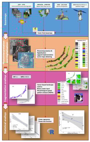
Figure 1.
Workflow of the multitemporal approach applied to the Costa Viola terraced landscape.
2.1. Study Area
Costa Viola is one of the main terraced areas of Italy and is listed in the National Register of Italian Historical Landscapes [21]. It is a strip of coastal land facing the Tyrrhenian Sea in the very south of the Italian Peninsula, in the region of Calabria, which lies along the strait which separates it from Messina and Sicily. Costa Viola, i.e., the Violet Coast, is so-called because of the particular colour the sea assumes at sunset. Its territory falls into five municipalities: Villa San Giovanni, Scylla, Bagnara Calabra, Seminara, and Palmi. This land has known civilization since ancient times. It is famous for the myth of Scylla and Charybdis, the legendary sea monsters, respectively, inhabiting the Calabrian and the Sicilian shores, narrated by Homer in the Odyssey. The study area (Figure 2) extends about 24.1 km2, being a strip 20 km long and 1–2 km large. It is characterised by steep slopes, mostly over 30° (54.74% of the whole area), cliffs, and deep valleys modelled over time by the erosive action of the so-called fiumare (the typical torrents characterising the Calabria region and the northeastern part of Sicily).
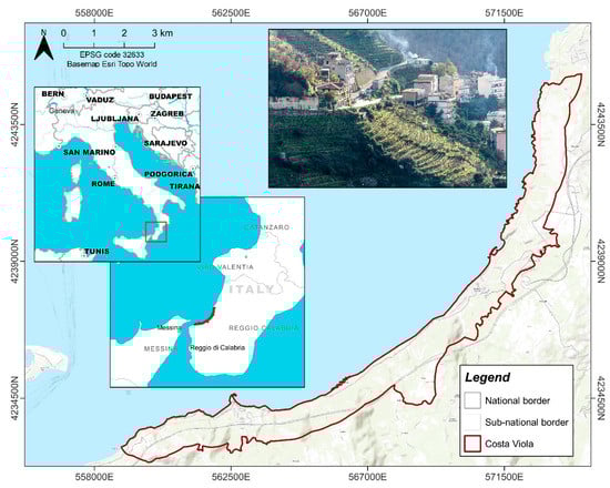
Figure 2.
Geolocalization of the study area, the Costa Viola landscape.
The present agricultural terraced system finds its original matrix in the work of landscape re-organization following the catastrophic earthquakes of 1783–1784 [56]. The narrow terraces are supported by earth retaining dry-stone walls integrated with complex drainage, irrigation, and circulation systems (channels, dry-stone stairs, and paths). Since the early 19th century, this terraced system in Costa Viola has made agriculture possible even on land with slopes over 70°, mainly for viticultural use and with a minor presence of olive and citrus growths. For decades, here, terraced viticulture has represented an almost heroic way of agricultural production, made possible in small and family-run farms and also by a favourable social and economic context. Over the 20th century, things have progressively and dramatically changed; since the 1930s, terraced viticulture, which requires very intense labour inputs, has undergone a general and rapid decline. Despite the loss of agricultural significance, the cultural importance of the terraced landscape of Costa Viola has, instead, progressively grown. Now, the need to manage this valuable landscape by coupling the original agricultural function (which needs to find new economic purposes) with the valorisation of its cultural attractiveness is widely recognised.
2.2. The Multitemporal Method
For the fragmentation-based framework of the analysed terraced landscape, first, the precise location of the terraced agricultural areas had to be determined. We identified the positions using aerial characteristic signs such as the presence of dry-stone walls. Moreover, to perform our analysis, we needed to know their shape, extent, and LU/LC in each investigated year. These data were obtained using a photointerpretation and manual digitalisation process. A georeferenced basemap for each of the seven investigated years was obtained as the first step of this process. Due to data availability and the temporal dimension of the analysed period, different sources were used (Table 1)

Table 1.
Main characteristics of the image sources used to obtain georeferenced base maps for each investigated year.
For the 1955 and 1976 images, a georeferencing process involving the use of ground control points (GCPs) directly collected in situ was followed to obtain orthophotos from the available aerial photos. More details about this process can be found in Modica et al., 2017 [29].
Once the base maps of the investigated years were obtained, a manual digitalisation was performed in a GIS environment following the regressive photointerpretation method [57]. Considering the high detail needed, digitalisation was conducted at a display scale between 1:900 and 1:1250, considering 0.20 ha as the minimum mapping unit. The CORINE land cover was adopted as the legend because of its hierarchical structure. Indeed, this legend is constructed according to precise hierarchies, starting from five items for the first hierarchical level and adding underlying levels as more information is provided [58]. The greater the number of details highlighted, the higher the hierarchical level will be [59]. This structure allowed us to add a specific hierarchical level dedicated to the terraced areas to discriminate them from the others. This process resulted in a vector layer with the LU/LC data, one for each investigated year, which were used to build the LU/LC maps. More details can be found in our previous studies on the same study area [29,44].
The obtained LU/LC maps were used to analyse the spatial patterns of the terraced agricultural areas highlighting their fragmentation dynamics. In this context, landscape metrics have been used to quantify and describe several spatial characteristics of landscape components [60,61]. Two simple vector-based landscape metrics were chosen to measure fragmentation dynamics in this study: the number of patches (NP), i.e., the number of terraced polygons showing active agricultural use during the photointerpretation process, and the mean patch size (MPS), i.e., the ratio between the total area occupied by agricultural terraces and the NP [47]. In our approach, a patch was not related to a single farm property, but it was a contiguous pattern of active agricultural terraces resulting from photointerpretation and digitalisation, without a link to the farm/property aspect. Moreover, to have a deeper view of the spatial structure and composition of the terraced agricultural areas (i.e., active terraces), we performed the MSPA [53,54,55] using the free open-source software Guidos (Graphical User Interface for the Description of image Objects and their Shape) Toolbox (GTB) version 2.9 [62]. The MSPA enabled the description of terraced systems by analysing the morphology of their main spatial constituents: core, islet, perforation, edge, loop, bridge, branch, core-opening, and border-opening (Table 2). Core indicates the most stable areas and represents the class to be preserved more than the others. In this view, for a deeper approach within core area dynamics, this morphological class was split into 3 subclasses: (i) small core (sCore), with an extent less than 1 ha; (ii) medium core (mCore), with an extent between 1 and 10 ha; (iii) large core (lCore), with an extent greater than 10 ha. The MSPA in GTB consists of binary raster-based analysis, considering just two data classes: “foreground”, the areas of which we want to know the spatial dynamics (i.e., active terraced systems) and “background”, all other areas. To obtain an active terraces/non-active terraces raster-based map, to be used as input for the MSPA, all vector-based LU/LC maps obtained during the previous phase were rasterised with a spatial resolution of 5 m. Adopting this resolution, the minimum map unit considered during the digitalisation process (0.2 ha) was sufficiently larger than the pixel size (about 80 times). Moreover, this resolution was a good compromise between spatial accuracy and needed processing time. The rasterisation process assigned the value 2 to all active agricultural terraced LU/LC (foreground) and 1 to all other LU/LC classes (background).
Table 2.
Main morphological spatial classes analysed and their short description [53,62].
Based on input data and given the objectives of this work, two spatial parameters were set to perform the MSPA in GTB: the foreground connectivity and the edge width. Foreground connectivity defines the connection of the centre pixel of a 3 × 3 moving window. Two possibilities are available: (i) 4-connectivity, considering the four pixels up, bottom, left, and right to the centre pixel and (ii) 8-connectivity, considering all pixels surrounding the centre pixel [62]. In this work, 8-connectivity was chosen. Edge width defines the width of the non-core area classes. A high edge width leads to a decrease in core areas and an increase in border areas [62]. Considering the high detail of the input data, a value of 1 was chosen for this parameter.
2.3. Statistical Analysis
The time series of class-level morphological spatial pattern metrics were tested for significance using a linear regression model for the period 1955–2014. Therefore, edge, bridge, and branch MSP classes were grouped into a single class named “connection”. Then, a linear model was fitted for relevant core, islet, edge, and connection classes metrics. A significant slope (β) parameter was considered to be a measure of the direction of the trend and the magnitude of the adjusted coefficient of determination (adjR2) as a morphological spatial pattern metrics trend [63]. The time series of landscape metrics were examined to characterise the landscape’s agricultural terraced patch dynamics and to provide information on the organization and stability of landscape composition and configuration. The base 10 logarithm values of MPS and NP, for the period 1955–2014, were plotted against and fitted by a power-law function for detecting breaks in the fit and were assumed to be related to disjunctions or departures from linearity of the observed agricultural terraced patch dynamics [64]. The statistical analysis was conducted in the R (4.1.0) software environment [65].
3. Results
The LU/LC maps were used to identify the total area occupied by active agricultural terraced LU/LC classes and their spatial configurations for each of the investigated years (Figure 3). In 1955, the total area occupied by active terraces, the main target of this study, was 813.25 ha, and a year-on-year decline occurred, thus, reaching 118.79 ha in 2014 (Table 3). More detail about other LU/LC classes can be found in Modica et al., 2017 [29]. An opposite tendency was highlighted for the NP metric that showed an increasing trend from 98 patches (in 1955) to 122 patches (in 2014), with a maximum of 157 patches (in 2008). This increase is linked with a decrease in the MPS from 8.30 ha (in 1955) to 0.97 ha (in 2014). Table 3 reports the total area occupied by agricultural terraces, the NP, and the MPS for each investigated year.
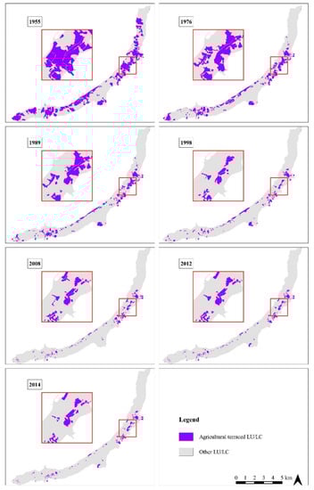
Figure 3.
The spatial configuration of agricultural terraced land use/land cover (LU/LC) for each of the years investigated in the time interval 1955–2014.
Table 3.
The extent of active agricultural terraced areas, number of patches (NP), and mean patch size (MPS) for each analysed year.
Concerning the MSPA, Figure 4 shows the spatial distribution of all analysed classes, while Figure 5 shows a synoptic framework of all classes in each of the investigated years. Due to different extensions of active agricultural terraces, representing foreground in the input data, the results are presented in terms of the occupied surface by each MSP class, expressed in hectares (Table 4 and Figure A1), and in terms of the relative importance of each class in the composition of the foreground, expressed in percentage (Table 5 and Figure A2).
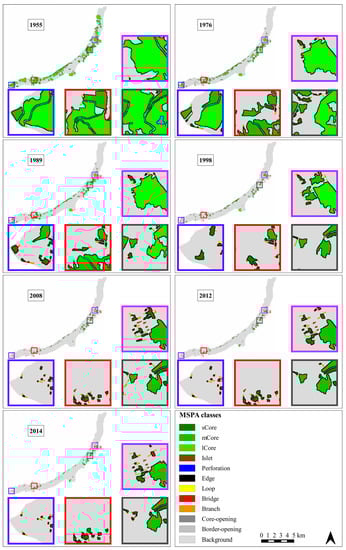
Figure 4.
Spatial configuration of morphological spatial pattern classes for each of the years investigated in the time interval 1955–2014.
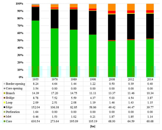
Figure 5.
Spatial morphological pattern class composition of the study area for each of the years investigated.
Table 4.
The total surface occupied by morphological spatial pattern classes analysed for each of the years investigated.
Table 5.
The relative importance of each morphological spatial pattern class expressed as a percentage of the total foreground area analysed for each of the years investigated.
Considering the core area class, it decreased from 630.54 ha (in 1955), representing 76.74% of the total foreground area, to 60.68 ha (in 2014) representing 51.71% of foreground area. The lowest percentage was recorded in 2008, with 49.03% of the total foreground classes area occupied, corresponding to 68.93 ha. Considering the three core subclasses, the sCore area increased from 12.20 ha (in 1955) to 14.59 ha (in 2014), and its relative percentage increased from 1.93% to 24.04% of the total area occupied by the core class. The mCore area decreased from 158.24 ha (in 1955) to 46.09 ha (in 2014), but its relative percentage increased from 25.10% to 75.96%. Finally, the lCore, which occupied a surface of 460.10 ha (in 1955), representing 72.97% of the core class area, disappeared in 2014. As a consequence of this trend, the edge class area constantly decreased from 152.04 ha (in 1955) to 39.77 ha (in 2014). Considering its percentages, an opposite trend was shown, increasing from 18.50% (in 1955) to 33.89% (in 2014), with a maximum of 35.16% (in 2008). Moreover, islet class (i.e., areas too small to contain core) increased from 0.46 ha (in 1955) to 1.14 ha (in 2014), representing 0.06% and 0.97%, respectively. The maximum surface occupied by this class was 1.87 ha (in 2008), while the maximum percentage was 1.43% (in 2012). Even loop, bridge, and branch classes (i.e., connection classes) showed a decrease in terms of the surface but an increase in terms of relative percentage. Loop slightly decreased from 2.09 ha (in 1955) to 1.15 ha (in 2014), but its relative percentage increased from 0.25 to 0.98 in the same years. Bridges decreased from 8.78 ha (in 1955) to 3.87 ha (in 2014), but the relative importance of this class increased from 1.07% to 3.29% at the two extreme years of the analysed period. Branches decreased from 14.39 ha (in 1955), corresponding to 1.75%, to 10.34 ha (in 2014), corresponding to 8.81%. The maximum area occupied by this class was 17.20 ha (in 1976), while the maximum percentage occupied was 9.51% (in 2008).
The time-series trend analysis of class-level morphological spatial pattern metrics showed a significant decreasing trend for core, edge, and connection class metrics. In contrast, the islet increasing trend was not significant (Figure 6). As expected, the relation between the landscape metrics did not display a power-law function, as the study area was an artificial environment. Nevertheless, two major breaks from the trend were detected (Figure 7).
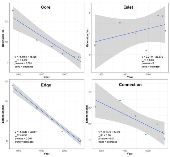
Figure 6.
The time-series trend analysis of the study area’s class-level morphological spatial pattern metrics from 1955 to 2014.
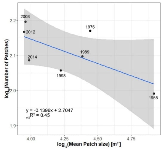
Figure 7.
The agricultural terraced patch dynamics of the study area from 1955 to 2014.
4. Discussion
By analysing the results of the digitalisation process, a decreasing trend of active agricultural terraced areas could be noticed. These areas registered a total loss of 694.46 ha during the analysed time interval, representing a percentage decrease of −85.39%. This dynamic is in line with the findings of other studies conducted in the same study area [29,43,44,46,66]. Moreover, as highlighted in several other studies, this decrease was strictly linked, on the one hand, with the more general abandonment of agricultural activities [67,68,69,70], especially in mountain areas [28,71], and on the other hand, with the abandonment of terraced agricultural systems [7,72,73,74,75,76]. It is important to highlight how, in these kinds of landscapes, fragmentation at the parcel/farm level, although resulting from specific dynamics, may reveal as strictly connected with fragmentation at the landscape level. We analysed a cultural landscape whose main constituents are agricultural terraces managed by single farmers. Should farmers, for different reasons, reduce or abandon the agricultural use of the land they own, this would inevitably reflect a lack of maintenance, and then progressive obsolescence and abandonment. This would reduce the functionality of the specific terraced parcels and also of the other adjacent parcels, progressively affecting, to a large extent, the functionality and the appearance of the wider and more complex terraced landscape system. In this process, the social construction and the social perception of landscape go together. If abandonment affects small areas distributed across the landscape, the integrity and continuity of its elements could be preserved without changing the perception of the whole landscape. If changes, instead, affect larger areas or are concentrated in restricted parts of the analysed territory, the perception of the landscape, being diminished in its distinctive character, could be greatly altered. The loss of cultural attractiveness, in turn, eliminates the advantage of the terraced landscape as a major feature, and the focus is on other important farm-based activities (tourism, cultural/educational initiatives, etc.) that can provide farmers with integrative incomes and offer additional motivations for keeping the agricultural use.
The MSPA results show fragmentation dynamics on the terraced agricultural systems. Core areas decrease and islets increase. Two main fragmentation dynamics have been highlighted thanks to the analysis of the intermediate years of the considered time interval. In fact, the first fragmentation dynamic occurs between 1955 and 1976 with an increase in islet areas from 0.46 ha to 1.53 ha. This class represents a less stable pattern. After the increase due to fragmentation, a decreasing trend is shown from 1976 to 1998, losing 1.32 ha and assessing the total amount of surface occupied by islet areas to be 0.21 ha. Then, a second fragmentation dynamic occurs between 1998 and 2008. This trend is highlighted by an increase in the total islet class area from 0.21 ha to 1.87 ha. After this year, again, a disappearing trend of this class can be noticed, decreasing from 1.87 ha to 1.14 ha. In addition, the edge class area decreases but its relative percentage increases. This means that during the analysed time interval, core areas became smaller, thus, less stable and subject to further future phenomena of fragmentation. If the fragmentation dynamic occurs in a core area, the result could be either a smaller core area or a pattern of smaller classes (bridges, branches, islets, etc.). If the fragmentation dynamic occurs at the expense of smaller classes, there is a real risk of permanent loss of those elements (Figure 4). The analysis of core area subclasses gives further evidence of this trend. In fact, the lCore class disappeared between 1998 and 2008 and the importance of the mCore and sCore classes increased during the entire time interval. This trend was in line with the findings of Heider et al. [45] who highlighted that small parcels were persistently cultivated in a Spanish terraced landscape. In other words, these small parcels can be interpreted as remnants of the original terraced landscape, gradually abandoned during the last century.
As a consequence of this fragmentation trend, loop, bridge, and branch (i.e., different kinds of connections between MSP classes) importance given by their relative percentages increase with a maximum peak that corresponds with the second fragmentation period highlighted (1998–2008). In this view, these connection classes can be considered to be the remains of bigger core areas that link different smaller ones. Finally, the values of perforation and core-opening classes that represent discontinuities inside core areas can be read as a sign of fragmentation dynamics that occurred before 1955, of which we do not have more details because it is outside of our considered time-span period and because of the lack of an available dataset.
The two above highlighted fragmentation dynamics are also shown by the analysis of the two considered landscape metrics. In fact, the NP values highlighted an initial increase in agricultural terraced patches between 1955 and 1976, then, a gradual decrease and another increase between 1988 and 2008, followed by another decreasing trend. These values are also accompanied by a reduction in MPS value, meaning that fragmentation affects the composition of the terraced agricultural landscape, moving from a situation characterised by a few agricultural terraced patches of larger size to another with many more patches but of much smaller size. Moreover, the analysis of agricultural terraced patch dynamics in the period 1955–2014 indicated a disjunction between both 1955–1976, and 1998–2008, and thus, confirmed that landscape fragmentation occurred in these time intervals. During these two time intervals, as reported by the Italian National Institute of Statistics (ISTAT, https://demo.istat.it—last access 10 January 2022), a significant decrease in the number of inhabitants of the five municipalities composing the study area can be noticed.
A comparison of the MSPA results, landscape metrics, and LU/LC mapping, clearly showed how fragmentation dynamics were strictly connected with the abandonment of the agricultural terraces. This finding was in line with the results of other scholars that have highlighted a connection between fragmentation and land abandonment [51,77].
5. Conclusions
This work aimed to describe the dynamics of a terraced landscape of historical and cultural relevance following a multitemporal fragmentation-based analysis approach. The main strength of this approach is the multitemporal dimension of the analysis. In fact, we considered the two extreme years of the time period investigated and five intermediate years. This approach allowed us to highlight two different fragmentation trends that otherwise could not have been identified. Furthermore, we showed the reliability of an MSPA (usually adopted to describe processes in the natural environment) adopted to a man-made landscape, to describe the dynamics that occurred, giving a detailed framework of the spatial composition of agricultural terraces by analysing the morphology of their components. This analysis can be a reliable tool for decision-makers to calibrate timely and tailored planning measures to protect specific core areas, and to improve other classes, in other words, to implement proper contrasting actions of the ongoing fragmentation and ensure the integrity and continuity of the constituting elements of a cultural landscape.
The main limitation of the multitemporal fragmentation-based analysis approach adopted is the need for up-to-date aerial base map images coupled with the time-consuming activities of photointerpretation and manual digitalisation of LU/LC to detect active agricultural terraces. Further research activities should involve the use of different remote sensing sources such as very high-resolution (VHR) satellite data with daily revisiting times to obtain constantly updated images. Satellite data could be integrated with unmanned aerial vehicles (UAVs) equipped with photogrammetric sensors to obtain detailed images, or with lidar sensors to easily detect terraced systems. Moreover, terrestrial laser scanner (TLS) and airborne laser scanner (ALS) data could be used for accurate investigations of the maintenance conditions of dry-stone walls. Finally, to avoid the time-consuming tasks of photointerpretation and manual digitalisation, a machine learning/deep learning approach could be implemented to achieve a semiautomatic classification of LU/LC.
A deeper knowledge of fragmentation dynamics and linked abandonment trends is a helpful tool in the decision-making process. It can be used to improve the knowledge of terraced agricultural landscape by identifying areas to be subjected to special protection and conservation measures and those to be subjected to improvement policies. In addition, it is a helpful tool on the basis of “integrity” criteria, particularly, in the examined area that UNESCO has listed in the convention for the safeguarding of intangible heritage in 2018.
The results of this study could be used to support the activities of decision-makers in contrasting the fragmentation dynamics, thus, preserving the role and the functionalities of the terraced agricultural landscape. In this view, in the last five years, the work of a few “heroic farmers” has been, in part, countering the abandonment dynamics outlined above by rescuing small terraced areas from abandonment and resuming cultivation practices. These areas should be the object of specific planning measures to improve their stability over time by offering structural conditions (infrastructures, financial support, and technical innovation) which can encourage those agriculture uses and farm-based complementary activities valorising the historical terraced landscape.
Author Contributions
Conceptualization, S.P., F.S., and G.M.; data curation, S.P.; formal analysis, investigation, methodology, software, S.P. and F.S.; supervision, S.D.F. and G.M.; validation, visualization, writing—original draft, writing—review and editing, S.P., F.S., S.D.F., and G.M. All authors have read and agreed to the published version of the manuscript.
Funding
The research of Dr Salvatore Praticò was partially funded by the project “PON Research and Innovation 201-2020—European Social Fund, action I.2 Attraction and International Mobility of Researcher—AIM1832342-1”.
Institutional Review Board Statement
Not applicable.
Informed Consent Statement
Not applicable.
Data Availability Statement
The data presented in this study are available in article.
Acknowledgments
The authors would like to thank the three anonymous reviewers for their insightful comments on the earlier version of the manuscript, contributing improving it significantly.
Conflicts of Interest
The authors declare no conflict of interest.
Appendix A

Figure A1.
Morphological spatial pattern analysis (MSPA) results in terms of the surface occupied by each class in each investigated year.
Figure A1.
Morphological spatial pattern analysis (MSPA) results in terms of the surface occupied by each class in each investigated year.


Figure A2.
Morphological spatial pattern analysis (MSPA) results in terms of the relative importance of each class in the composition of the foreground for each investigated year and expressed as a percentage.
Figure A2.
Morphological spatial pattern analysis (MSPA) results in terms of the relative importance of each class in the composition of the foreground for each investigated year and expressed as a percentage.

References
- Antrop, M. Why landscapes of the past are important for the future. Landsc. Urban Plan. 2005, 70, 21–34. [Google Scholar] [CrossRef]
- Council of Europe. European Landscape Convention; Council of Europe: Florence, Italy, 2000. [Google Scholar]
- Latocha, A. Land-use changes and longer-term human-environment interactions in a mountain region (Sudetes Mountains, Poland). Geomorphology 2009, 108, 48–57. [Google Scholar] [CrossRef]
- Di Fazio, S.; Modica, G. Historic Rural Landscapes: Sustainable Planning Strategies and Action Criteria. The Italian Experience in the Global and European Context. Sustainability 2018, 10, 3834. [Google Scholar] [CrossRef]
- Latocha, A.; Reczyńska, K.; Gradowski, T.; Świerkosz, K. Landscape memory in abandoned areas—Physical and ecological perspectives (Central European mountains case study). Landsc. Res. 2019, 44, 600–613. [Google Scholar] [CrossRef]
- Troiano, C.; Buglione, M.; Petrelli, S.; Belardinelli, S.; De Natale, A.; Svenning, J.C.; Fulgione, D. Traditional free-ranging livestock farming as a management strategy for biological and cultural landscape diversity: A case from the southern apennines. Land 2021, 10, 957. [Google Scholar] [CrossRef]
- Tarolli, P.; Preti, F.; Romano, N. Terraced landscapes: From an old best practice to a potential hazard for soil degradation due to land abandonment. Anthropocene 2014, 6, 10–25. [Google Scholar] [CrossRef]
- Moser, K.F.; Ahn, C.; Noe, G.B. The Influence of Microtopography on Soil Nutrients in Created Mitigation Wetlands. Restor. Ecol. 2009, 17, 641–651. [Google Scholar] [CrossRef]
- Agnoletti, M.; Errico, A.; Santoro, A.; Dani, A.; Preti, F. Terraced landscapes and hydrogeological risk. Effects of land abandonment in Cinque Terre (Italy) during Severe rainfall events. Sustainability 2019, 11, 235. [Google Scholar] [CrossRef]
- Wei, W.; Chen, D.; Wang, L.; Daryanto, S.; Chen, L.; Yu, Y.; Lu, Y.; Sun, G.; Feng, T. Global synthesis of the classifications, distributions, benefits and issues of terracing. Earth-Sci. Rev. 2016, 159, 388–403. [Google Scholar] [CrossRef]
- Deng, C.; Zhang, G.; Liu, Y.; Nie, X.; Li, Z.; Liu, J.; Zhu, D. Advantages and disadvantages of terracing: A comprehensive review. Int. Soil Water Conserv. Res. 2021, 9, 344–359. [Google Scholar] [CrossRef]
- Košulič, O.; Michalko, R.; Hula, V. Recent artificial vineyard terraces as a refuge for rare and endangered spiders in a modern agricultural landscape. Ecol. Eng. 2014, 68, 133–142. [Google Scholar] [CrossRef]
- Collier, M.J. Field Boundary Stone Walls as Exemplars of ‘Novel’ Ecosystems. Landsc. Res. 2013, 38, 141–150. [Google Scholar] [CrossRef]
- Biddoccu, M.; Zecca, O.; Audisio, C.; Godone, F.; Barmaz, A.; Cavallo, E. Assessment of Long-Term Soil Erosion in a Mountain Vineyard, Aosta Valley (NW Italy). Land Degrad. Dev. 2018, 29, 617–629. [Google Scholar] [CrossRef]
- Brandolini, P.; Cevasco, A.; Capolongo, D.; Pepe, G.; Lovergine, F.; Del Monte, M. Response of Terraced Slopes to a Very Intense Rainfall Event and Relationships with Land Abandonment: A Case Study from Cinque Terre (Italy). Land Degrad. Dev. 2018, 29, 630–642. [Google Scholar] [CrossRef]
- Kladnik, D.; Kruse, A.; Komac, B. Terraced landscapes: An increasingly prominent cultural landscape type. Acta Geogr. Slov. 2017, 57, 73–81. [Google Scholar] [CrossRef]
- Zhang, Y.; He, L.; Li, X.; Zhang, C.; Qian, C.; Li, J.; Zhang, A. Why are the Longji Terraces in Southwest China maintained well? A conservation mechanism for agricultural landscapes based on agricultural multi-functions developed by multi-stakeholders. Land Use Policy 2019, 85, 42–51. [Google Scholar] [CrossRef]
- Zhang, W.; Ricketts, T.H.; Kremen, C.; Carney, K.; Swinton, S.M. Ecosystem services and dis-services to agriculture. Ecol. Econ. 2007, 64, 253–660. [Google Scholar] [CrossRef]
- Chen, D.; Wei, W.; Daryanto, S.; Tarolli, P. Does terracing enhance soil organic carbon sequestration? A national-scale data analysis in China. Sci. Total Environ. 2020, 721, 137751. [Google Scholar] [CrossRef] [PubMed]
- United Nations Educational Scientific and Cultural Organisation (UNESCO). Convention Concerning the Protection of the World Cultural and Natural Heritage. 1972. Available online: https://whc.unesco.org/en/conventiontext/ (accessed on 10 January 2022).
- Agnoletti, M.; Santoro, A.; Gardin, L. Italian Historical Rural Landscapes; Environmental History; Agnoletti, M., Ed.; Springer: Dordrecht, The Netherlands, 2013; Volume 1, Available online: http://link.springer.com/10.1007/978-94-007-5354-9 (accessed on 10 January 2022).
- Santoro, A.; Venturi, M.; Agnoletti, M. Agricultural heritage systems and landscape perception among tourists. The case of Lamole, Chianti (Italy). Sustainability 2020, 12, 3509. [Google Scholar] [CrossRef]
- Rössler, M. UNESCO and cultural landscape protection. In Cultural Landscapes of Universal Value Components of a Global Strategy; Von Droste, B., Plachter, H., Rössler, M., Eds.; Gustav Fischer Verlag: New York, NY, USA, 1993; pp. 42–49. [Google Scholar]
- United Nations Educational Scientific and Cultural Organisation (UNESCO). Operational Guidelines for the Implementation of the World Heritage Convention; UNESCO: Paris, France, 2021. [Google Scholar]
- Modica, G.; Vizzari, M.; Pollino, M.; Fichera, C.R.; Zoccali, P.; Di Fazio, S. Spatio-temporal analysis of the urban-rural gradient structure: An application in a Mediterranean mountainous landscape (Serra San Bruno, Italy). Earth Syst. Dyn. 2012, 3, 263–279. [Google Scholar] [CrossRef]
- Lasanta, T.; Arnáez, J.; Pascual, N.; Ruiz-Flaño, P.; Errea, M.P.; Lana-Renault, N. Space–time process and drivers of land abandonment in Europe. Catena 2017, 149, 810–823. [Google Scholar] [CrossRef]
- Ramankutty, N.; Foley, J.A. Estimating historical changes in global land cover: Croplands from 1700 to 1992. Glob. Biogeochem. Cycles 1999, 13, 997–1027. [Google Scholar] [CrossRef]
- MacDonald, D.; Crabtree, J.; Wiesinger, G.; Dax, T.; Stamou, N.; Fleury, P.; Gutierrez Lazpita, J.; Gibon, A. Agricultural abandonment in mountain areas of Europe: Environmental consequences and policy response. J. Environ. Manag. 2000, 59, 47–69. [Google Scholar] [CrossRef]
- Modica, G.; Praticò, S.; Di Fazio, S. Abandonment of traditional terraced landscape: A change detection approach (a case study in Costa Viola, Calabria, Italy). Land Degrad. Dev. 2017, 28, 2608–2622. [Google Scholar] [CrossRef]
- Lasanta, T.; Errea, M.P.; Nadal-Romero, E. Traditional Agrarian Landscape in the Mediterranean Mountains. A Regional and Local Factor Analysis in the Central Spanish Pyrenees. Land Degrad. Dev. 2017, 1640, 1626–1640. [Google Scholar] [CrossRef]
- Lieskovský, J.; Bezák, P.; Špulerová, J.; Lieskovský, T.; Koleda, P.; Dobrovodská, M.; Bürgi, M.; Gimmi, U. The abandonment of traditional agricultural landscape in Slovakia—Analysis of extent and driving forces. J. Rural Stud. 2015, 37, 75–84. [Google Scholar] [CrossRef]
- Garcìa-Ruiz, J.M.; Lana-Renault, N.N.; García-Ruiz, J.M.; Lana-Renault, N.N. Hydrological and erosive consequences of farmland abandonment in Europe, with special reference to the Mediterranean region—A review. Agric. Ecosyst. Environ. 2011, 140, 317–338. [Google Scholar] [CrossRef]
- Llorens, P.; Latron, J.; Gallart, F. Analysis of the role of agricultural abandoned terraces on the hydrology and sediment dynamics in a small mountainous basin (High Llobregat, Eastern Pyrenees). Pirineos 1992, 139, 27–46. Available online: http://pirineos.revistas.csic.es/index.php/pirineos/article/view/180/179 (accessed on 10 January 2022). [CrossRef]
- Moreno-de-las-Heras, M.; Lindenberger, F.; Latron, J.; Lana-Renault, N.; Llorens, P.; Arnáez, J.; Romero-Díaz, A.; Gallart, F. Hydro-geomorphological consequences of the abandonment of agricultural terraces in the Mediterranean region: Key controlling factors and landscape stability patterns. Geomorphology 2019, 333, 73–91. [Google Scholar] [CrossRef]
- Romero Díaz, A.; Marín Sanleandro, P.; Sánchez Soriano, A.; Belmonte Serrato, F.; Faulkner, H. The causes of piping in a set of abandoned agricultural terraces in southeast Spain. Catena 2007, 69, 282–293. [Google Scholar] [CrossRef]
- Arnáez, J.; Lana-Renault, N.; Lasanta, T.; Ruiz-Flaño, P.; Castroviejo, J. Effects of farming terraces on hydrological and geomorphological processes. A review. Catena 2015, 128, 122–134. [Google Scholar] [CrossRef]
- Tilliger, B.; Rodríguez-Labajos, B.; Bustamante, J.; Settele, J. Disentangling Values in the Interrelations between Cultural Ecosystem Services and Landscape Conservation—A Case Study of the Ifugao Rice Terraces in the Philippines. Land 2015, 4, 888–913. [Google Scholar] [CrossRef]
- Praticò, S.; Solano, F.; Di Fazio, S.; Modica, G. A Fragmentation-Based Analysis of Costa Viola (Southern Italy) Agricultural Terraces. In Innovation in Urban and Regional Planning INPUT 2021 Lecture Notes in Civil Engineering; La Rosa, D., Privitera, R., Eds.; Springer: Berlin/Heidelberg, Germany, 2022; Volume 242, pp. 152–159. [Google Scholar] [CrossRef]
- Cillis, G.; Statuto, D.; Picuno, P. Historical gis as a tool for monitoring, preserving and planning forest landscape: A case study in a mediterranean region. Land 2021, 10, 851. [Google Scholar] [CrossRef]
- Capolupo, A.; Kooistra, L.; Boccia, L. A novel approach for detecting agricultural terraced landscapes from historical and contemporaneous photogrammetric aerial photos. Int. J. Appl. Earth Obs. Geoinf. 2018, 73, 800–810. [Google Scholar] [CrossRef]
- Demoulin, A.; Bovy, B.; Rixhon, G.; Cornet, Y. An automated method to extract fluvial terraces from digital elevation models: The Vesdre valley, a case study in eastern Belgium. Geomorphology 2007, 91, 51–64. [Google Scholar] [CrossRef]
- Agnoletti, M.; Conti, L.; Frezza, L.; Santoro, A. Territorial analysis of the agricultural terraced landscapes of Tuscany (Italy): Preliminary results. Sustainability 2015, 7, 4564–4581. [Google Scholar] [CrossRef]
- Di Fazio, S.; Modica, G. The valorisation and characterisation of the agrarian terraced landscape. A case study in the Costa Viola area (Italy). In Proceedings of the International Conference of Agricultural Engineering CIGR-AgEng, Valencia, Spain, 8–12 July 2012. [Google Scholar]
- Modica, G.; Praticò, S.; Pollino, M.; Di Fazio, S. Geomatics in Analysing the Evolution of Agricultural Terraced Landscapes. In Lecture Notes in Computer Science (Including Subseries Lecture Notes in Artificial Intelligence and Lecture Notes in Bioinformatics); Springer: Cham, Switerland, 2014; pp. 479–494. [Google Scholar] [CrossRef]
- Tarolli, P.; Sofia, G.; Calligaro, S.; Prosdocimi, M.; Preti, F.; Dalla Fontana, G. Vineyards in Terraced Landscapes: New Opportunities from Lidar Data. Land Degrad. Dev. 2015, 26, 92–102. [Google Scholar] [CrossRef]
- Lanucara, S.; Praticò, S.; Modica, G. Harmonization and Interoperable Sharing of Multi-temporal Geospatial Data of Rural Landscapes. In Smart Innovation, Systems and Technologies; Springer: Cham, Switerland, 2019; pp. 51–59. [Google Scholar] [CrossRef]
- Solano, F.; Praticò, S.; Piovesan, G.; Chiarucci, A.; Argentieri, A.; Modica, G. Characterising historical transformation trajectories of the forest landscape in Rome’s Metropolitan area (Italy) for effective planning of sustainability goals. Land Degrad. Dev. 2021, 32, 4708–4726. [Google Scholar] [CrossRef]
- Penghui, J.; Dengshuai, C.; Manchun, L. Farmland landscape fragmentation evolution and its driving mechanism from rural to urban: A case study of Changzhou City. J. Rural Stud. 2021, 82, 1–18. [Google Scholar] [CrossRef]
- Rahman, S.; Rahman, M. Impact of land fragmentation and resource ownership on productivity and efficiency: The case of rice producers in Bangladesh. Land Use Policy 2009, 26, 95–103. [Google Scholar] [CrossRef]
- Modica, G.; Praticò, S.; Laudari, L.; Ledda, A.; Di Fazio, S.; De Montis, A. Implementation of multispecies ecological networks at the regional scale: Analysis and multi-temporal assessment. J. Environ. Manag. 2021, 289, 112494. [Google Scholar] [CrossRef] [PubMed]
- Heider, K.; Rodriguez Lopez, J.M.; Balbo, A.L.; Scheffran, J. The state of agricultural landscapes in the Mediterranean: Smallholder agriculture and land abandonment in terraced landscapes of the Ricote Valley, southeast Spain. Reg. Environ. Chang. 2021, 21, 23. [Google Scholar] [CrossRef]
- Turner, M.G.; Gardner, R.H. Landscape Ecology in Theory and Practice; Springer: New York, NY, USA, 2015; Available online: http://link.springer.com/10.1007/978-1-4939-2794-4 (accessed on 10 January 2022).
- Soille, P.; Vogt, P. Morphological segmentation of binary patterns. Pattern Recognit. Lett. 2009, 30, 456–459. [Google Scholar] [CrossRef]
- Vogt, P.; Riitters, K.H.; Iwanowski, M.; Estreguil, C.; Kozak, J.; Soille, P. Mapping landscape corridors. Ecol. Indic. 2007, 7, 481–488. [Google Scholar] [CrossRef]
- Vogt, P.; Riitters, K.H.; Estreguil, C.; Kozak, J.; Wade, T.G.; Wickham, J.D. Mapping Spatial Patterns with Morphological Image Processing. Landsc. Ecol. 2007, 22, 171–177. [Google Scholar] [CrossRef]
- Graziani, L.; Maramai, A.; Tinti, S. A revision of the 1783–1784 Calabrian (southern Italy) tsunamis. Nat. Hazards Earth Syst. Sci. 2006, 6, 1053–1060. [Google Scholar] [CrossRef]
- Andrieu, E.; Ladet, S.; Heintz, W.; Deconchat, M. History and spatial complexity of deforestation and logging in small private forests. Landsc. Urban Plan. 2011, 103, 109–117. [Google Scholar] [CrossRef]
- Solano, F.; Colonna, N.; Marani, M.; Pollino, M. Geospatial Analysis to Assess Natural Park Biomass Resources for Energy Uses in the Context of the Rome Metropolitan Area. In International Symposium on New Metropolitan Perspectives; Springer: Cham, Switzerland, 2019; pp. 173–181. [Google Scholar] [CrossRef]
- Buttner, G.; Kosztra, B.; Maucha, G.; Pataki, R.; Kleeschulte, S.; Hazeu, G.; Vittek, M.; Schroder, C.; Littkopf, A. Copernicus Land Monitoring Service. CORINE Land Cover User Manual. European Union, Copernicus Land Monitoring Service 2001, European Environment Agency (EEA). 2021, p. 129. Available online: https://www.eea.europa.eu/publications/COR0-landcover (accessed on 10 January 2022).
- McGarigal, K. Landscape Pattern Metrics. In Encyclopedia of Environmetrics; Wiley StatsRef Stat Ref Online: Hoboken, NJ, USA, 2014; pp. 1–13. [Google Scholar] [CrossRef]
- Vizzari, M.; Sigura, M. Urban-rural gradient detection using multivariate spatial analysis and landscape metrics. J. Agric. Eng. 2013, 44. [Google Scholar] [CrossRef]
- Vogt, P.; Riitters, K. GuidosToolbox: Universal digital image object analysis. Eur. J. Remote Sens. 2017, 50, 352–361. [Google Scholar] [CrossRef]
- Olsen, L.M.; Washington-Allen, R.A.; Dale, V.H. Time-Series Analysis of Land Cover Using Landscape Metrics. GIScience Remote Sens. 2005, 42, 200–223. [Google Scholar] [CrossRef]
- Milne, B.T. “Fundamentals of Landscape Organization: Coupled Networks, Thresholds, and Allometry” in Integration of Societal and Landscape Heterogeneity: Problems and Solutions. In Proceedings of the 15th Annual Symposium of the US Regional Association and International Association of Landscape Ecology and Second Conference of the Walt Dineen Society, Ft. Lauderdale, FL, USA, 15–19 April 2012. [Google Scholar]
- R Core Team. R: A Language and Environment for Statistical Computing; R Foundation for Statistical Computing: Vienna, Austria, 2021; Available online: https://www.r-project.org/ (accessed on 10 January 2022).
- Agnoletti, M.; Cargnello, G.; Gardin, L.; Santoro, A.; Bazzoffi, P.; Sansone, L.; Pezza, L.; Belfiore, N. Traditional landscape and rural development: Comparative study in three terraced areas in northern, central and southern Italy to evaluate the efficacy of GAEC standard 4.4 of cross compliance. Ital. J. Agron. 2011, 6, 16. [Google Scholar] [CrossRef]
- Lambin, E.F.; Meyfroidt, P. Global land use change, economic globalization, and the looming land scarcity. Proc. Natl. Acad. Sci. USA 2011, 108, 3465–3472. [Google Scholar] [CrossRef] [PubMed]
- Baumann, M.; Kuemmerle, T.; Elbakidze, M.; Ozdogan, M.; Radeloff, V.C.; Keuler, N.S.; Prishchepov, A.V.; Kruhlov, I.; Hostert, P. Patterns and drivers of post-socialist farmland abandonment in Western Ukraine. Land Use Policy 2011, 28, 552–562. [Google Scholar] [CrossRef]
- Rey Benayas, J.M. Abandonment of agricultural land: An overview of drivers and consequences. CAB Rev. Perspect. Agric. Vet. Sci. Nutr. Nat. Resour. 2007, 2. [Google Scholar] [CrossRef]
- Marcheggiani, E.; Gulinck, H.; Galli, A. Detection of Fast Landscape Changes: The Case of Solar Modules on Agricultural Land. In International Conference on Computational Science and Its Applications; Springer: Berlin/Heidelberg, Germany, 2013; pp. 315–327. [Google Scholar] [CrossRef]
- Molinillo, M.; Lasanta, T.; García-Ruiz, J.M. Managing Mountainous Degraded Landscapes after Farmland Abandonment in the Central Spanish Pyrenees. Environ. Manag. 1997, 21, 587–598. [Google Scholar] [CrossRef] [PubMed]
- Koulouri, M.; Giourga, C. Land abandonment and slope gradient as key factors of soil erosion in Mediterranean terraced lands. Catena 2007, 69, 274–281. [Google Scholar] [CrossRef]
- Lesschen, J.P.; Cammeraat, L.H.; Nieman, T. Erosion and terrace failure due to agricultural land abandonment in a semi-arid environment. Earth Surf. Process. Landf. 2008, 33, 1574–1584. [Google Scholar] [CrossRef]
- Stavi, I.; Rozenberg, T.; Al-Ashhab, A.; Argaman, E.; Groner, E. Failure and collapse of ancient agricultural stone terraces: On-Site effects on soil and vegetation. Water 2018, 10, 1400. [Google Scholar] [CrossRef]
- Kizos, T.; Dalaka, A.; Petanidou, T. Farmers’ attitudes and landscape change: Evidence from the abandonment of terraced cultivations on Lesvos, Greece. Agric. Hum. Values 2010, 27, 199–212. [Google Scholar] [CrossRef]
- Petanidou, T.; Kizos, T.; Soulakellis, N. Socioeconomic dimensions of changes in the agricultural landscape of the Mediterranean basin: A case study of the abandonment of cultivation terraces on Nisyros Island, Greece. Environ. Manag. 2008, 41, 250–266. [Google Scholar] [CrossRef] [PubMed]
- Sakellariou, M.; Psiloglou, B.E.; Giannakopoulos, C.; Mylona, P.V. Integration of Abandoned Lands in Sustainable Agriculture: The Case of Terraced Landscape Re-Cultivation in Mediterranean Island Conditions. Land 2021, 10, 457. [Google Scholar] [CrossRef]


Publisher’s Note: MDPI stays neutral with regard to jurisdictional claims in published maps and institutional affiliations. |
© 2022 by the authors. Licensee MDPI, Basel, Switzerland. This article is an open access article distributed under the terms and conditions of the Creative Commons Attribution (CC BY) license (https://creativecommons.org/licenses/by/4.0/).