Article

Urban-Rural Dependencies and Opportunities to Design Nature-Based Solutions for Resilience in Europe and China

1
Department of Urban and Environmental Sociology, UFZ-Helmholtz Centre for Environmental Research, 04318 Leipzig, Germany
2
Department of Educational Anthropology, Danish School of Education, Aarhus University, 2400 Copenhagen, Denmark
3
Paris Region Biodiversity Agency, Paris Region Institut, CEDEX 15, 75740 Paris, France
4
Department of Asian Studies, Faculty of Humanities, Hebrew University of Jerusalem, Jerusalem 9190401, Israel
5
Department of Environmental Sciences, Aarhus University, 4000 Roskilde, Denmark
6
UK Centre for Ecology & Hydrology, Environment Centre Wales, Deiniol Road, Bangor LL57 2UW, UK
7
Department of Politics, University of Exeter, Exeter EX4 4QG, UK
8
Ministry of Education Key Laboratory for Biodiversity Science and Ecological Engineering, Coastal Ecosystems Research Station of the Yangtze River Estuary, Shanghai Institute of EcoChongming (SIEC), Fudan University, Shanghai 200433, China
9
Ministry of Education Key Laboratory for Earth System Modeling, Department of Earth System Science, Institute for Global Change Studies, Tsinghua University, Beijing 100084, China
10
Department of Environmental Science & Aarhus University Interdisciplinary Centre for Climate Change (iCLIMATE), Aarhus University, 4000 Roskilde, Denmark
*
Author to whom correspondence should be addressed.
Land 2022, 11(4), 480; https://doi.org/10.3390/land11040480
Submission received: 22 February 2022 / Revised: 21 March 2022 / Accepted: 23 March 2022 / Published: 26 March 2022
(This article belongs to the Special Issue Urban-Rural-Partnerships: Sustainable and Resilient)

Abstract

:
Interrelationships between urban and rural areas are fundamental for the development and safeguarding of viable future living conditions and quality of life. These areas are not well-delineated or self-sufficient, and existing interrelations may privilege one over the other. Major urban challenges facing China and Europe are related to changes in climate, environment, and to decision-making that makes urban and rural landscapes more susceptible to environmental pressures. Focusing on the six European and Chinese cities and surrounding rural areas, under study in the joint EC and MOST-funded REGREEN project, we examine how nature-based solutions (NBS) may assist in counteracting these pressures. We explore urban-rural dependencies and partnerships regarding NBS that can enhance resilience in Europe and China. We analyse differences between European and Chinese systems of governance, reflecting on the significance of the scale of research needed to understand how NBS provide benefits. We highlight interactions between differently delineated sheds (watershed, airshed, natureshed, and peopleshed), which influence the interrelationships between urban and rural areas. There may be one-way or two-way interdependence, and the impact may be uni or multi-directional. The European and Chinese solutions, exemplified in this article, tackle the nexus of environmental and peoplesheds. We discuss complex human interactions (and how to model them) that may, or may not, lead to viable and equitable partnerships for implementing NBS in cities within Europe and in China.

1. Introduction

Urbanisation is one of the most challenging processes we face in the 21st century. This calls for new thinking to create robust collaboration across urban-rural areas that fosters sustainable development in both [1]. While many interrelations between urban and adjacent rural areas exist, these may be skewed in ways that favour one over the other [2,3]. To ensure that such interrelations contribute to a balanced regional partnering from which both areas benefit, interdependencies must be made explicit, with potential asymmetries sounded out [4,5]. Forging sustainable and resilient urban-rural partnerships requires formulating central questions and acknowledging challenges [6]. Especially when designing nature-based solutions (NBS), we must understand that water, air, and nature provide ecosystem services for people, both in and across the areas in which they live and work [7]. Hence, the partnering of urban-rural interests, in relation to watersheds, airsheds, and naturesheds in urban-rural spaces, should be beneficial for an entire peopleshed, which is understood, here, to encompass all who live and work in and across a particular rural and urban area [8,9]. By renewing our understanding of these interlinkages, we may re-adjust our strategies for forging well-functioning and equitable partnerships.
Urban and rural areas are not well-delineated, bounded, or self-sufficient spaces [10]. Rather, comprising areas of different land cover and land use, as well as the different mobility patterns this entails, they are closely intertwined and intensively dependent on each other [11,12]. In a physical sense, they are simultaneously sources and sinks in the resource cycle, especially when it comes to nutrition, water, energy, waste, and housing [1,13,14]. Their interrelationship is, thus, fundamental for the development and safeguarding of viable living conditions and the quality of life in a particular region. Viability, here, relates to jobs and livelihoods, housing markets, recreation, education, and basic supply for residents in a well-balanced way across rural and urban areas [15]. The United Nations’ global Sustainability Development Goals (SDGs) propose, in SDG target 11a, that urban-rural links are a critical nexus for planning well-functioning regions [16]. Such a nexus must be based on a more sustainable design of economic, social, political, and environmental urban-rural interaction.
Drawing on the ongoing REGREEN project (https://www.regreen-project.eu/, accessed on 22 March 2022 ), this article presents examples from China and Europe, which help to understand the importance of different local and cultural contexts for restoring, enhancing, and creating urban and rural, as well as green and blue, infrastructure. We consider cultural histories, societal challenges, topographies, climate, governance systems, and economic and social structures as underlying factors that influence resilience and social cohesion in urban and rural areas. We use and combine these factors to illustrate good examples on both continents. The aim is to generate transferable knowledge of sustainable urban development under different conditions, which can be directly applicable to other cities. Interactions between ecosystems and human societies are highly complex [17,18,19], with multiple forms of interaction and feedback loops that constantly change both natural and societal systems. For this reason, we follow a holistic social-ecological framework that outlines interrelationships between ecological and social issues to restore and rehabilitate urban ecosystems, as well as enhance sustainable urbanisation in China and Europe.
Major urban challenges, pertinent to both China and Europe, are related to changes in climate and environment. They are also related to historical and current decision-making and management approaches that make urban and adjacent rural landscapes more susceptible to pressures such as flooding or noise, resulting in loss of urban biodiversity, green areas, and open streams. Urbanisation and mass transport have a persistent impact on air quality and health. Different population densities steer accessibility to greenspace and induce asymmetries between urban and rural areas. We will examine how NBS may assist in counteracting these challenges by focusing on six focal European and Chinese cities, and their surrounding rural areas, that are our study sites in the above-mentioned EC and MOST funded project. Acknowledging differences between European and Chinese systems of governance, we learn from exploring the cultural contexts in and between China and Europe. The study seeks to understand urban-rural dependencies and partnerships, regarding NBS, which contribute to amending resilience in Europe and China. The novelty of this research is in the interlinkage of various “sheds” to foster NBS in urban-rural areas. To do so, we put emphasis on conceptualising “people” in urban-rural interlinkages to assess urban-rural NBS, the broad benefits to people, and the challenge of how best to manage the use of, and people’s interaction with, the natural environment in urban and rural areas. Our paper seeks to address the following questions:
  • How can we explore viable NBS at different scales, and how may they differ in China and Europe?
  • How does governance contribute to balancing the specific needs of urban and rural areas in China and Europe?
  • How can we tackle the complex human interactions in urban-rural areas with regard to implementing NBS?
The novelty of this research contribution lies in the comparison of governance structures and NBS implementation strategies, between European and Chinese cities with a regional focus… With a view to the conceptual contribution, the novelty is highlighting the concept of peopleshed, as a non-metric size, and linking it to the NBS scales of watershed, airshed, and natureshed to bring in a broader and more differentiated view on the benefits of NBS.

2. Conceptual Understanding of Urban-Rural Interaction in Selected European and Chinese Regions

2.1. Study Area Selection

The selected cities are all participants in the EC- and MOST funded REGREEN project. The advantage of this selection is manifold. First, to actively participate in this project, these cities have committed themselves to implement NBS for a more equitable, greener, and healthier city. With departments of these cities as active project members, we have a common understanding of all the research efforts we undertake to foster NBS. Second, to comprehend and chart urban areas at various extents, it is important to exemplify representative types. Hence, we have chosen to include megacities such as Shanghai, Beijing, and the Paris Region, as well as typical medium-sized cities, such as Ningbo in China and Aarhus in Europe, and even a small Croatian town of Velika Gorica, in the study. Finally, this selection affords valuable data and information, such as scale dependencies, functional areas, governance structures, knowledge about different ‘scales’, and initial experiences, that we are using to improve urban-rural partnerships through NBS. Dependent on the illustration of urban-rural partnerships in the different cases (see Section 3), we may relate to the city’s boundary or to the functional urban area in which interlinkages with and within peoplesheds occur. Finally, we also have the relevant expertise to illustrate and elaborate the different aspects of the significant European and Chinese situations.

2.2. Developing NBS at Various Urban-Rural Boundaries

Following the call for new integrated territorial planning approaches, as well as people and place-based development at urban-rural interfaces, aligned with localised SDGs, we present and discuss recent attempts to develop such approaches. Integrated planning accounts for the manifold interrelations and linkages between urban and rural spaces.
During periods of rapid urbanisation, intricate, historically evolved urban-rural metabolisms are often at risk, exacerbating environmental, social, and economic sustainability challenges. In this context, NBS offer a useful conceptual framework in which to readdress contemporary multidimensional and multi-scalar challenges—climate change resilience, biodiversity loss, and social inequity—facing both urban and rural areas. To enable the implementation of NBS, governance structures must be understood and addressed. These structures vary between China and Europe, as well as within Europe, at both national and regional levels. Although research on urban governance has increased in recent years, it still lacks analyses of spatial concern, spatial effectiveness, and further-reaching approaches that address space-based solutions for integrated food and substance circuits, as well as innovative settlement models in—particular, cultural landscapes. Steering urban-rural space calls for new forms of institutional collaboration, and here, governance research is still at the beginning (Section 2.3).
When targeting sustainable regional development and, more specifically, how best to achieve an integrated governance of urban-rural relationships, our descriptions and analyses must address conceptual, methodological, and empirical issues. Balancing interests between urban and rural areas in ways that respect their particularities is important for achieving equitable qualities of life. While such questions of urban-rural dependencies and parities are not yet resolved, it is imperative to address them to encourage and promote ways of “partnering” that provide attractive and viable living conditions in an entire region. A myriad of bottlenecks has become obvious and discussed [20,21,22,23]. Overcoming such bottlenecks may lead to novel ways of partnering between urban and rural communities to create viable and lasting solutions. Efficient land-use management plays a significant role when it comes to developing regionally integrated patterns of settlement. We thus need to exemplify mechanisms and best practices that may lead to implementing processes of resilient urban development, which are also transferable to other locations. For example, interventions for air quality purification can be planned either in suburban or rural areas in order to decrease air pollution in cities [24,25]. The optimum locations for planting new woodlands can be evaluated and planned using modelling approaches, which evaluate where there will be lowered concentrations of pollutants (the benefit-plume) as a result of planting new woodland. These show the calculated change in PM2.5 concentration that result from pollution removal by woodland in that location, taking into account real-world emission sources and meteorology. Such model applications can be used to reduce the PM2.5 concentrations in urban areas as well as providing aesthetic values in the rural area. Additionally, city-regional strategies can align political priorities across urban-rural divides and provide green and blue corridors, as well as local water retention areas, to alleviate risks of flooding in cities as well as in rural villages and farmlands (see Section 3.2) [26].
Tackling the issue of whether urban-rural interactions are continuous or dis-continuous raises questions around spatial attributes [27]. We may define urban-rural space as a physical continuity delimited by a catchment area (see Section 2.4) or by other (topographical) features that restrict and channel movement. We may also define urban-rural space as bounded administrative units, well-delineated to manage spatial planning. More striking, perhaps, is the less-used spatial defining tool of “peopleshed”, referring, in general, to people who reside and work in and across an urban-rural area, who make social demands on, and undertake recreational and cultural activities in both, and thus set socio-cultural boundaries at another dimension. Juxtaposing these defining criteria reveals the blurred and dynamic quality of urban-rural demarcation. In contrast to the urban footprint, a peopleshed has no hard boundary. What constitutes the urban and rural is, thus, much more than just the spatial extent or administrative assignment. We must explore static and dynamic spatial patterns over time to gain a deeper understanding of their dynamics, especially in terms of land-use management and conflicts resulting from this. Interactions between urban and rural areas are not stable over time. For this reason, we might need to forge a more complex definition of what comprises urban and rural by delineating their mutual functionalities, the movements and flows between them, variations in nightlight intensities, and their physical, administrative, conceptual, and social boundaries. While current thinking focuses on how biophysical structures and processes (natural capital) support services that benefit people, it is important to consider how they are co-produced across social strata.

2.3. Developing NBS at Multiple Scales

Spatial scales are key to understanding how NBS deliver benefits. Several principles underlie this claim. First, the ecological processes, which deliver benefits, operate at different scales. The cooling of heat island effects by urban greenspace is primarily a local benefit, felt within a greenspace area such as a park, and typically up to 200–300 m away [28]. At the other end of the scale, carbon sequestration benefits are transferred globally, due to atmospheric mixing and the long timescales involved in climate change [29]. Even for a single benefit, such as cooling by a park, there are scale effects—the direct shading from the sun only occurs under the tree canopy, while evapotranspirative cooling of the local air may extend a few hundred metres [30,31]. Second, those processes provide benefits to people only when there are people to receive them; this is also called “realised ecosystem services” [32] or demand [33]. Ecological processes, such as water flows and air mass movement, together with the daily or seasonal patterns of human mobility, produce complex spatial interactions in the supply and delivery of ecosystem service benefits. Given that urban and rural areas do not exist in isolation of each other, inter-relations between the two can be used to help enhance the supply of NBS benefits in both directions. Hutchins et al. [34] propose multi-domain relationships, which explain both size-dependency effects of NBS and distance-decay relationships for the benefit received from a given NBS (see Figure 1). These relationships are often non-linear and vary by type of benefit provided. Knowing how these processes work, and the scales (and directions) at which they operate, it is possible to define “sheds”, which are differently delineated areas with various kinds of interactions between urban and rural areas (Figure 1). They interdepend in a one-way or two-way flow, they may be uni or multi-directional, and they will differ for the respective domains such as water, air, nature, and people. These domains can be referred to as watersheds, airsheds, or naturesheds, and beyond these, most importantly, as peoplesheds (see Section 2.4).
Watersheds, airsheds, and peoplesheds seldom completely overlap. They are differently delineated and characterized by different drivers, structures, and dynamic patterns of movement and flow. Watershed, airshed, and natureshed are defined by their regional extent, their temporal limitation, and their environmental importance for urban-rural interaction. In the urban-rural interface, peoplesheds comprise biophysical, socio-demographic, socio-economic, and socio-cultural scales of human influence, as well as mobility aspects, with varying boundaries, trajectories, and flows of people (Section 2.4).

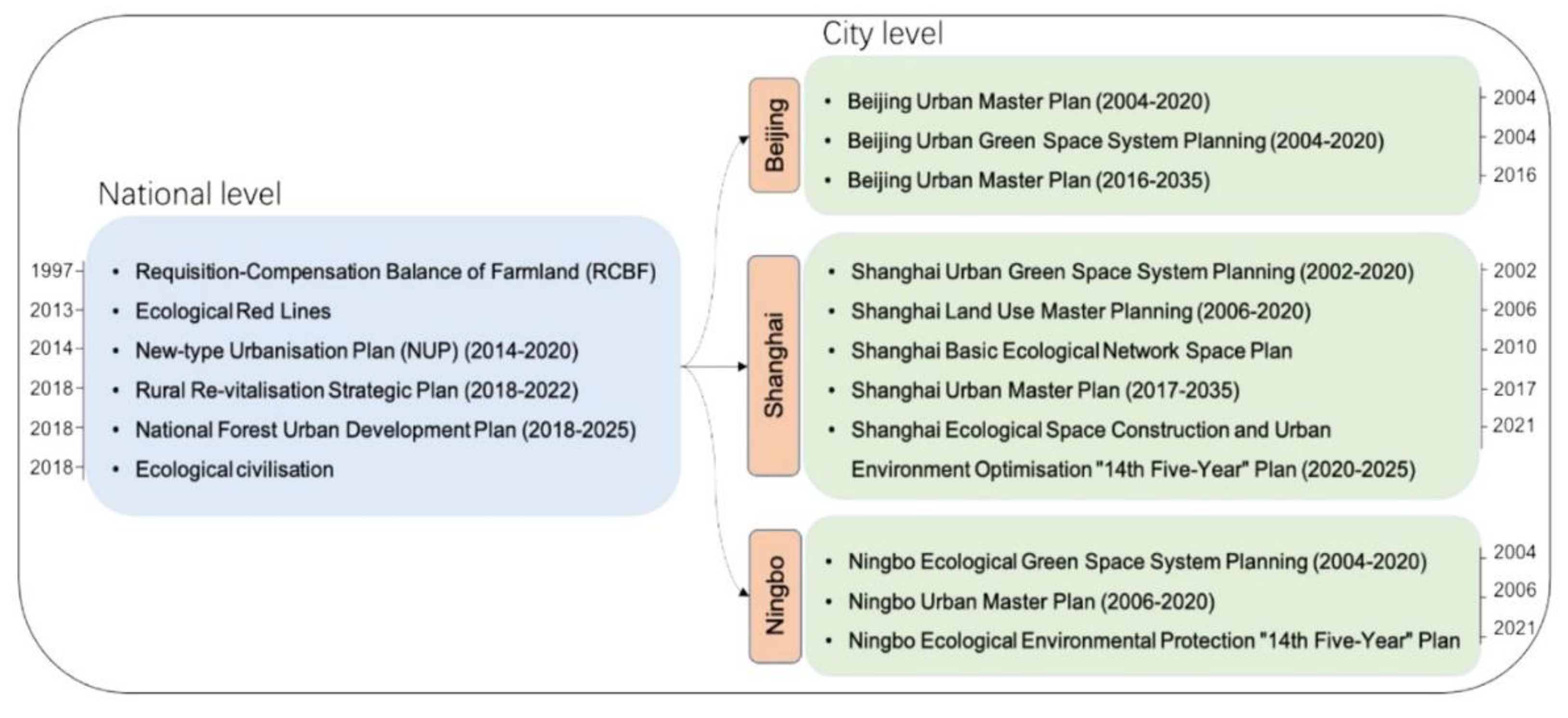
2.4. Governance of Urban-Rural Interaction across China and Europe

Various regulatory and market-based instruments exist to govern urban-rural relationships that enhance resilience. Urban strategies, land use planning, and zoning are efficient instruments to coordinate, prepare, and design the (multi-)functionality of areas and sectoral activities. Such urban strategies and planning laws, and especially how they are conceived and implemented, differ across European countries and between Europe and China, accentuated by different governance and planning systems, governing capacities, and resources. Furthermore, the extent, speed, and intensity of urban sprawl varies greatly between European and Chinese urban areas. While case-study cities in Europe have grown at a modest pace (11.6%) over the last 20 years, significant growth rates (84%) in Chinese case-study cities have, during the same period, led to a massive expansion into adjacent rural regions (Figure 2).
Governance is influential in limiting the process of urban sprawl, stimulating change in land use functions, and fostering a more sustainable development of urban and rural areas, even deepening their interactions. With the growing challenges of climate hazards, notably flooding and biodiversity degradation, additional land management instruments in urban-rural zones will often be needed. Policy instruments to manage urban-rural interactions involve command and control (e.g., deciding planning and zoning laws), market-based compulsory financial mechanisms (e.g., charges on landowners if their land does not meet requirements to retain water locally), and market-based voluntary incentives (e.g., land acquisition and pre-acquisition, easements, subsidies/compensation, or conditional performance contracting). Changes in policymaking and planning procedures, as well as altered political priorities, may also affect the urban-rural interactions, leading, e.g., to coordinated climate adaptation interventions [36] and influencing NBS-based business development [37] across the urban-rural divide. Depending on a society’s reference point for determining whether a landowner’s practices represent a negative or a positive externality [38], the urban-rural relationship may be dominated by regulations and taxes (e.g., on landowners, both urban and rural, who fail to meet environmental standards, in land management, that protect urban and rural areas) or dominated by incentives (e.g., to landowners who change land use practices towards natural flood management beyond regulations).
The Chinese government has proposed many urban-rural interaction policies since the 1990s [39,40,41] (Figure 3). In 1997, the central government issued the policy of “Requisition-compensation Balance of Farmland (ECBF)”, which is a strict policy aimed at controlling farmland conversion and replenishing farmland loss caused by urban expansion. In 2012, the concept of “ecological civilization” was formally adopted as a national development strategy, and “Beautiful China” was set up as the main goal. Written into the Chinese constitution in 2018, the concept of ecological civilisation has become the guiding policy for China to achieve a balance between environmental protection and development. A central theme of ecological civilisation is to realize an integrated development between urban and rural areas. In 2013, “Ecological Red Lines” was implemented as a national policy aimed at reforming eco-protection management and promoting ecological civilisation. In 2014, China issued the “New-type Urbanization Plan (NUP) (2014–2020)”, which is directed to a more sustainable urbanisation, expanding domestic demand, and rural-urban coordination. Since 2018, the government proposed the “Rural Re-vitalization Strategic Plan (2018–2022)” in which terms such as “green development”, “strengthening resource conservation and utilization”, “clean agricultural production”, and “rural ecological protection and restoration” are explained in detail. At the city level, the three urban agglomerations, Beijing, Shanghai, and Ningbo, have proposed various policies related to urban-rural interactions (Figure 3). For example, the Beijing government issued the “Beijing Urban Master Plan (2016–2035)”, which aimed to build a new type of city with green wisdom, distinctive features, liveability, and workability. Shanghai’s Ecological Space Construction and Urban Environment Optimization “14th Five-Year” Plan (2020–2025) targeted the building of an “ecological city”, with the aim of improving the ecological quality and functions of the urban and rural park system. Ningbo’s Ecological Environmental Protection “14th Five-Year” Plan also defined air quality as “fresh”, water quality as “clear”, and introduced various soil quality concepts to improve urban-rural interactions.
The governance situation in the European Union (EU) is very different from that seen in China. In the European Union, decision-making competencies and governance, surrounding urban-rural interactions and NBS, reside primarily with member states. How urban-rural relationships work in the European Union is, therefore, very much dependent on the constitutional composition of the member state, urban strategies, and localised planning policies. This means that some urban municipalities (e.g., Paris) in some member states are fairly strong political actors in and of themselves, risking rather fragmented governance between urban areas and their rural counterparts. Other urban municipalities—for example, in more federal systems—can be less powerful and subordinate to a higher tier of government that is the principal regional decision-maker able to enact policy approaches that cut across urban-rural divides. This is not to say that there are no policies at the EU level that seek to address urban-rural relations and NBS, but unlike the situation in China, these tend to be soft, non-binding policies, and they are less explicitly focused on urban-rural relationships in relation to NBS. This is mainly due to the EU subsidiarity principle that prompted the formulation and adoption of the European Spatial Development Perspective, with the aim of providing a common basis for member states’ planning. The Perspective has pushed spatial policies to be placed under EU cohesion policy [42,43], which implies that planning is a member-state competence, while many adjacent policy areas, such as climate mitigation, water policy, and air quality, are subject to EU policies and regulations. In 1999, the European Spatial Development Perspective had a specific objective relating to the development of urban-rural partnerships [44]. While non-binding, this objective provides guidelines to all tiers of planning authorities. More recently, an informal meeting of member state planning ministers agreed on the Territorial Agenda 2030 (https://territorialagenda.eu/ accessed on 22 March 2022) to help promote territorial cohesion in European regions, including cohesion between urban and rural areas. Moreover, Cohesion Funds, aimed at programmes seeking to reduce disparities between regions in the EU, may also play a role in facilitating stronger urban-rural relationships.
In relation to NBS, the European Union’s Urban Agenda [45] highlights the importance of NBS and related biodiversity for adapting to climate change, but it does not explicitly deal with urban-rural relationships in this context. The EU initiated a Research and Innovation policy agenda on NBS to include the re-naturing of cities and territorial resilience [46]. Preceding this EU agenda on NBS, the EU committed to a GI strategy for the protection of natural capital [47], and the Resource Efficiency Roadmap [48] identified investment in Green Infrastructure as an important step towards protecting natural capital. Over the past decade, the EU has placed the use of nature and ecosystem-based approaches at the centre of several policies with urban-rural implications, including climate change adaptation [47], flood management [49], water retention [50], biodiversity [48], and disaster risk management [51,52]. More recently, the ambitions of working with nature have been strengthened in the EU Biodiversity Strategy for 2030 [53], with legally binding nature restoration targets, the Strategy on Adaptation to Climate Change [54], and the Forest Strategy [54]. These policies represent key pillars of the European Green Deal [55], relying on NBS to, i.a., increase resilience to climate change impacts by preserving and restoring ecosystems and managing forests sustainably. Given that these policies are generic, they can be applied at a scale that encompasses urban-rural linkages, and, indeed, they would require enhanced collaboration between urban and rural communities.
The patchwork of EU policies related to NBS and urban-rural relationships, coupled with the fact that decision-making on these aspects rests largely with member states, means that governance structures in this area are rather fragmented. It is, therefore, not surprising that the approaches taken in the three European cities studied in REGREEN are very different. For instance, Velika Gorica (Croatia) is still in the early stages of NBS planning; with an interest primarily in green roofs, planning is more focused on the urban built-up area. In contrast, the Paris region (France) and Aarhus (Denmark) have more encompassing polices in place, which, among other things, involve interventions on the urban-rural boundaries (see Section 3).

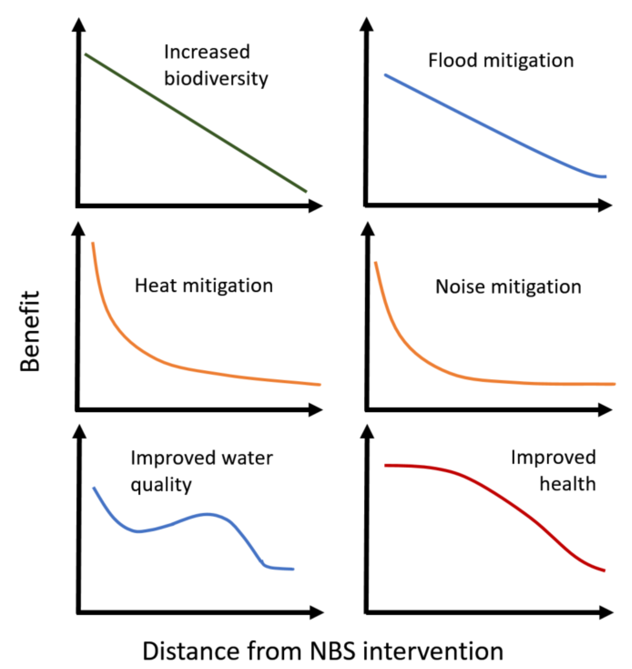
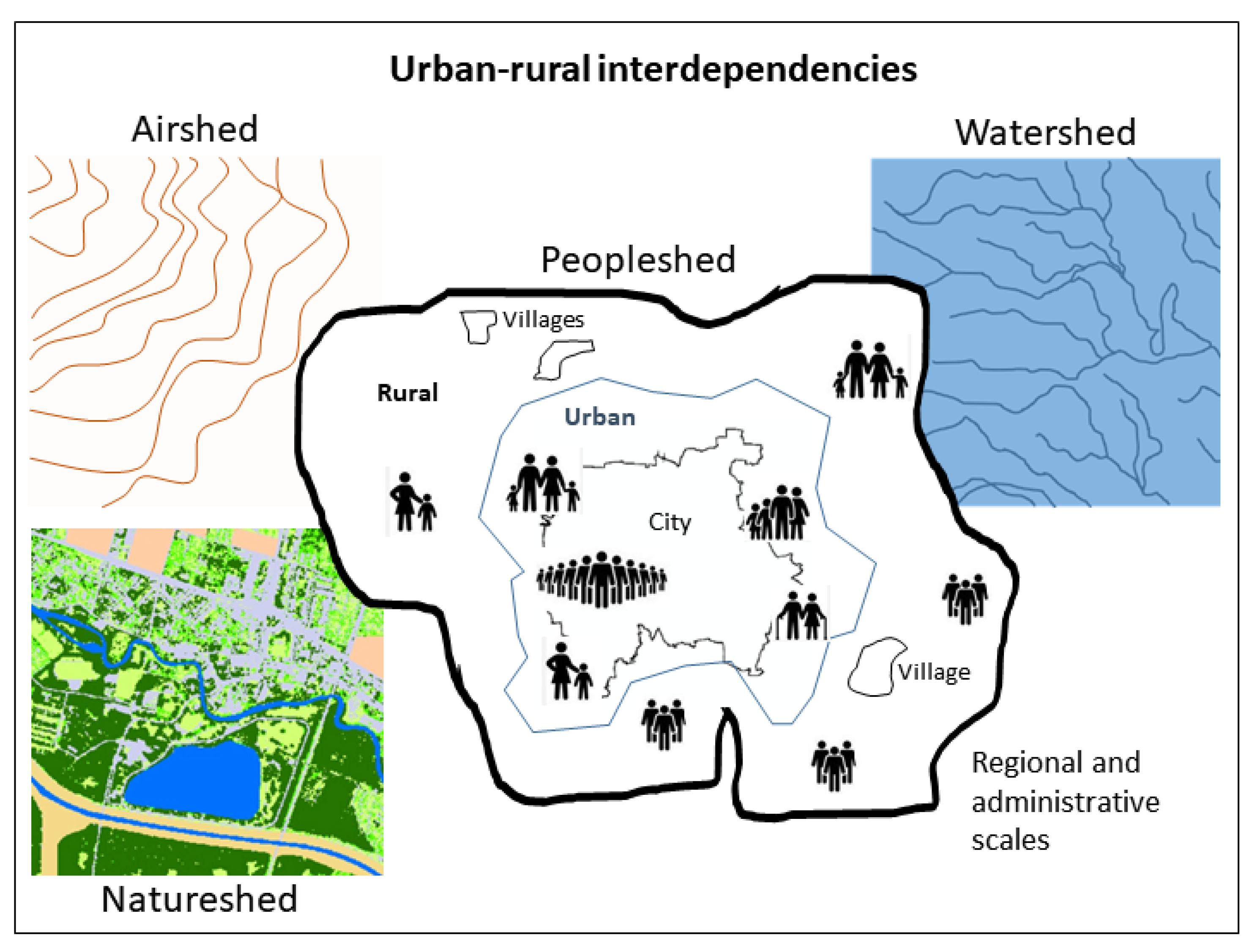
2.5. Supply and Demand of ES for Urban-Rural Interdependencies for Various “Sheds”

Direct regional interdependencies between urban and rural areas become very clear when modelling ecosystem services such as flood regulation. Localised urban-rural regions are also part of a larger space in which several urban and rural areas are interconnected. In the following, we discuss how watersheds, airsheds, naturesheds, and peoplesheds exemplify this larger spatial context in different ways. Due to the spatial context for the urban-rural interconnectedness, the origin of impacts, as well their effects, differ in space and time.
Watersheds are a central concept in hydrology and simply illustrate the principle that activities in a catchment, upstream of a rural area or a city, will affect the volume and timing of water flows, as well as the sediment load and agrochemical content [56] of the water flowing through the settlement. A watershed may be understood as an area from which all precipitation flows to a single stream or set of streams [57]. Its drainage divides natural, as well as built, areas in their respective boundaries: surface water, ground water, as well as larger and smaller subunits. In contrast to rural areas, the large impermeable space of cities is much more exposed to extreme events, such as flash floods. Together, the surface and sub-surface drainage infrastructure, designed to rapidly shift water away from the city, will also affect water flows into rural areas downriver and, possibly, other cities further downstream [58]. Similarly, industrial processes, traffic, air pollution, and waste management infrastructures are likely to substantially affect water quality downstream [59]. Watersheds neatly illustrate how inter-connected rural and urban areas are at multiple scales.
The same principles apply to airsheds. They may be understood as a highly dynamic “catchment area” above land, the extent of which varies on any given day, according to the current weather situation. Comprising a much larger area than watersheds, airsheds are differently bounded with different patterns of flow, transportation, and deposition. Air pollutant emissions from urban areas upwind, agricultural emissions of ammonia compounds, and bare ground, leading to the entrainment of dust particles, are all potential air pollutants that then travel over cities and affect the background atmospheric pollution load [60], which, in turn, affects the health of city residents as much as the locally generated air pollutants in the city. Air masses moving over a city will pick up additional pollutants from the city and transport them over downwind rural areas. Ground-level (tropospheric) ozone concentrations are typically higher in rural areas [61] because the precursor chemicals generated in urban areas are transported downwind, while some of the more reactive chemicals, such as nitric oxide, which reduce ozone concentrations in cities, only travel much shorter distances before they are broken down.
Naturesheds, or biodiversity sheds, can be seen as the circulating interactions of plants and animals across rural and urban areas. These interactions may, for example, include the use of water bodies in cities as stopping points for migratory wildfowl, particularly in arid areas. There are also daily foraging or roosting patterns for species, which might roost or lay up in rural areas while sleeping but move into cities during the day (or night) to feed, taking advantage of gardens or waste as food sources. Some species show the opposite behaviour—for example, bats that roost under bridges but move out into the surrounding rural areas to feed at night.
As with air, water, flora, and fauna, people are both situated and mobile. A peopleshed may, thus, be delineated by patterns of human dwellings and mobility across broader, interdependent urban-rural areas in ways that variously impact them. Such patterns encompass daily commutes, weekend and holiday travel, recreational activities, and configurations of public and private space. They may be driven by basic needs (livelihood, shelter, education) or social organisation, forms of relatedness, and cultural understandings (identity, well-being, social networks, place attachment, and aesthetic preference). More importantly, people are not, in essence, urban or rural. They may reside and work in, or across, urban and rural areas. This mobility may be patterned by age (children and the elderly are often more sedentary than working adults) and by life cycles, as people move to urban areas for education/work and “back to the country” to raise families or retire. Finally, a peopleshed may be delineated as a “community type”, a linked social and biophysical spatial entity invested by ownership, stewardship, social relations, and, most importantly, by values placed on socio-physical landscape characteristics [62,63,64] (see Section 3.3 and Section 3.4). Peoplesheds, thus delineated, place social demands on ecosystems, water, woodland, air, and biodiversity, which may be both ecologically and socially beneficial [64] (see Section 3.4).
In conceptualizing urban-rural interaction, and in modelling the “reach” of various NBS benefits, we must consider interdependencies forged by flows of air, water, animals, plants, goods, and people. Taken together, watersheds, airsheds, naturesheds, and peoplesheds allow for a comprehensive assessment of urban-rural NBS, the totality of its benefits to people, and how best to manage people’s use of, and engagement with, natural environments in urban and rural areas (Figure 4).

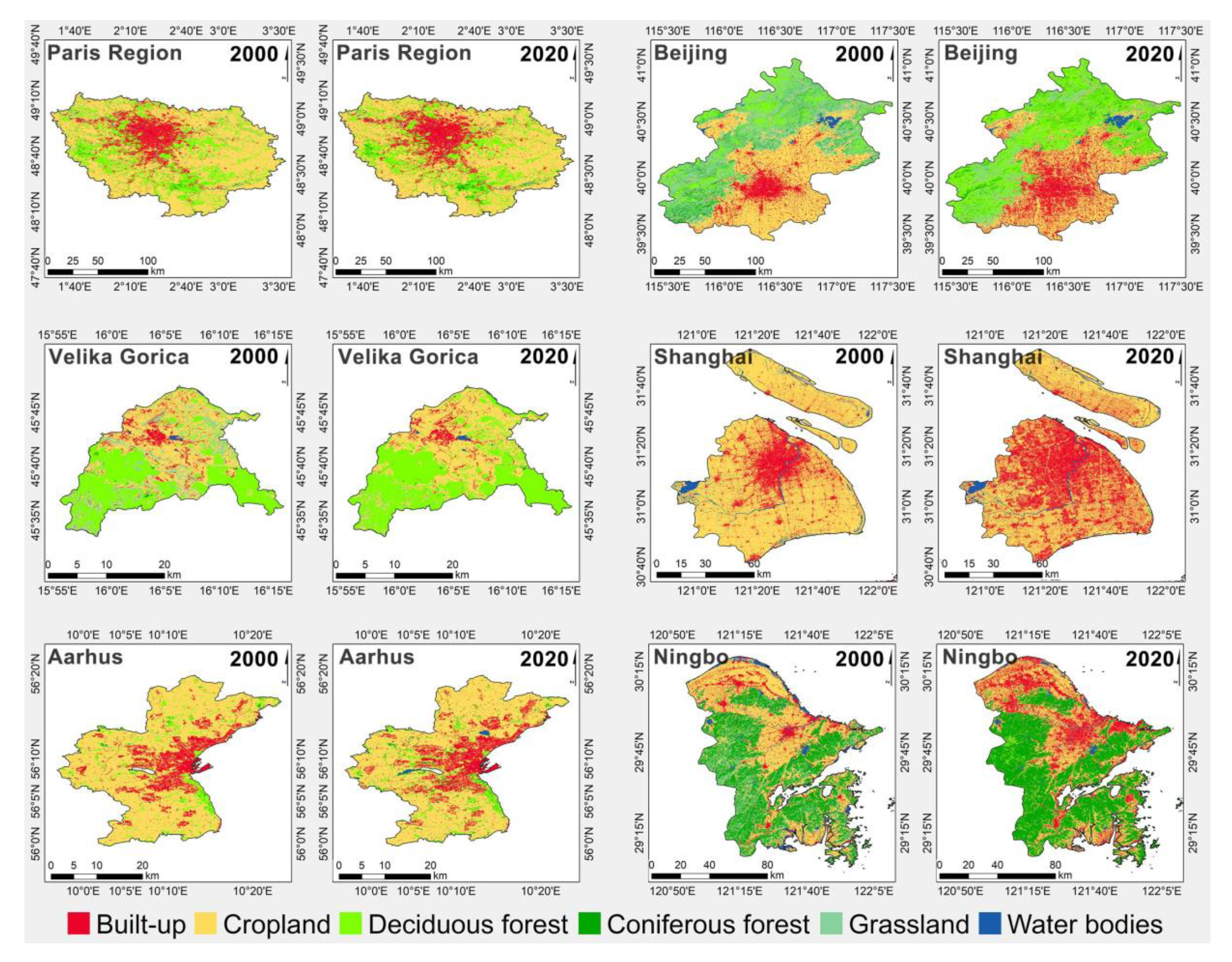
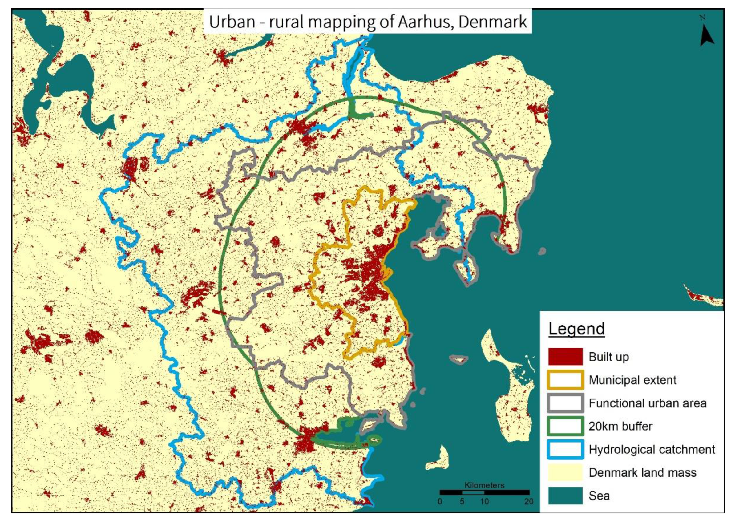
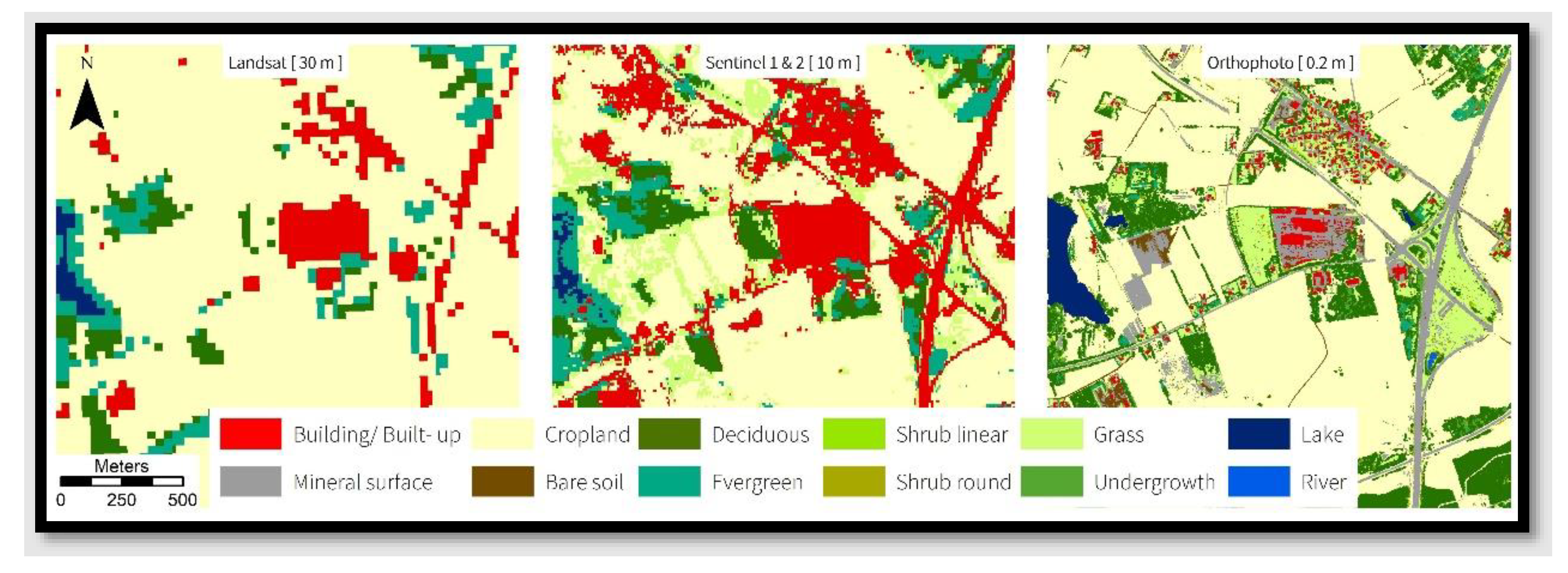
2.6. Defining and Mapping Urban and Rural Areas

To better understand specific urban-rural interactions, consistent mapping approaches are needed [65]. This mapping should include all the mentioned interrelated factors if they can be spatially explicit. Aside from gridded population data and maps of human settlements, which both imply a peopleshed, available global or continental land cover products do not distinguish precisely between urban and rural areas. They are somewhat lacking, as their goal is either to map an urban landscape in the functional urban area, including peri-urban and suburban areas, as well as commuting zones [66], but leaving out surrounding rural areas, or to create maps of a more global nature.
Thus, different thematic and spatial resolutions do not necessarily represent both the urban and rural land cover [67]. Most importantly, the focus and resolution of the thematic contents vary widely; they may, for example, either favour urban land-cover classes (e.g., a built-up area) or generalise them for a more homogeneous output linked to the spatial resolution of the respective “shed” [68,69].
These biases can be partially overcome by studying the differences in existing information in urban and rural peoplesheds. Different spatial extents picture administrative delineations and model other representations, such as the functional urban area that encompasses a peopleshed, delineated by human mobility. This functional urban area stretches further beyond the city and the municipal limits. The different extents enhance the understanding of the benefits that NBS of different scales provide (Figure 5). By comparing different markers, i.e., (i) administrative boundaries, (ii) urban extent, and the above-mentioned (iii) watershed, airshed, natureshed, and peopleshed, we attempt to find balance between the size of the area of interest and the spatial extent needed to study urban-rural interactions. For this reason, we added a 20 km buffer to undertake analyses in the different sheds.
To map different structures and patterns of urban and rural areas, we need to define the appropriate scale, as the influence of scale on mapping land cover has long been documented [70]. The scale is usually adapted to the smallest element, which can vary extremely between urban and rural settings. Therefore, finding an appropriate scale that best pictures an urban and rural area can be challenging. To avoid losing any details, we suggest a smallest common denominator approach: choosing the best-fitting scale based on the smallest element of interest.
In the REGREEN project, we made these considerations when defining goals for mapping urban-rural interactions. Figure 6 illustrates the differences in represented land cover classes, based on the chosen scale, and the resolution of the input data influencing the thematic resolution. The low-resolution mapping focuses on the extent of municipal boundaries. A buffer was extended for the mapping of Sentinel 1 and 2 data to cover the airshed of a given city. As for the high-resolution mapping, a smaller buffer was created around the municipal boundaries to include rural areas. Such a buffer was mostly restricted by computational time, but it could be extended further in the future.
The novelty of this study is to connect the different “sheds”, such as watersheds, airsheds, and naturesheds, with peoplesheds. All of them tackle different scales in the urban-rural extents. Consequently, we neither relate to just one urban scale, nor do we determine one single spatial extent for all NBS implementations (Section 3). We profit from the myriad of data we have at hand, at the various scales, to conceptualise our approach and illustrate it with initial solutions.

3. Solutions for Improving Urban-Rural Partnerships through NBS to Increase Resilience

In this section, we highlight cases from Europe and China that show the employment of NBS, through different forms of urban-rural collaboration, with the aim of mitigating environmental challenges to urban areas. In many of these cases, rural partners (stakeholders representing a particular livelihood) have received economic compensation for their part in creating and maintaining NBS (forest, wetlands) that benefit urban dwellers, regarding challenges posed by air pollution and flooding. The presentation is followed by a brief discussion of the potential contribution of relevant peopleshed models to NBS design and collaboration.

3.1. Collaborative NBS Solutions for Addressing Airshed Problems by Tackling Resource Dependency—The Million-Mu Afforestation Project around Beijing, China

Urban expansion often takes a toll on rural areas. Farmlands, wetlands, and other lands of important ecological value are converted into built-up areas. The impact is the strongest at the urban-rural interface. In addition to land loss, these interfaces are often sites for placing waste, generated in landfills, in the urban fringe. Polluted environment conditions cause a decrease in crop yields and lead to health problems, such as a rising incidence of chronic diseases among rural residents [71]. While farmers may have a strong desire to tackle the problem, they often lack the skill and resources to act alone. Solutions originating from urban areas, on the other hand, often do not take the social and economic welfare of farmers into consideration. For example, the idea in China to turn illegal dumping sites on farmlands into suburban parks may solve the pollution problem, but it simultaneously creates livelihood issues for rural residents.
The “Million-mu Afforestation Project” (one million mu ≈ 66,667 ha), initiated in Beijing, China, provides an example of how authorities may work together, across the rural-urban interface, to address environmental problems in both zones while simultaneously maintaining livelihoods in rural areas. The project, initiated in 2012, aimed to plant one million mu tree plantations in Beijing over a five-year period. Most plantations are located on fallowed farmlands and waste lands located at the current urban-rural interface [72]. The planting programme was a response to deteriorating urban environment conditions, as Beijing has just experienced the worst smog problem in its history. In addition, each spring, the city suffers from heavy dust storms blowing in particulate matter from remote bare land or from the desert. During this same period, the city experienced rapid expansion. Between 2000 and 2020, built-up areas increased from 1640 km2 to 2860 km2—a 74% increase [35]. It was urgent to control the rapid urban sprawl to protect residents in both urban and rural areas. The planting programme thus served the dual purposes of improving the environment and containing rapid urban expansion. Unlike other planting programmes in China, the “Million-mu Afforestation Project” set up a mechanism to financially benefit rural residents. Instead of expropriating farmland, the city government rents the land, thereby providing farmers with a stable source of income. In addition, the Beijing government hires farmers to care for the plantations, providing them with yet another income source.
With the support of farmers, the five-year project was completed in less than four years. In 2018, the government initiated another “Million-mu Afforestation Project” for the period of 2018–2022. So far, the project has been credited for a series of ecosystem services, which include removing air pollutants, alleviating the urban heat island, improving urban biodiversity, and providing recreational opportunities [73,74]. There is also evidence that farmers benefit, both ecologically and economically, from the project [75]. The example shows that understanding urban and rural residents, as an integrated peopleshed delineated by their common dependency on clear air, can lead to ways of addressing environmental problems without sacrificing the social and economic welfare of one group of residents and landowners over the other. Urban authorities compensate rural landowners and residents through land rent and job opportunities associated with the project, and both areas receive ecosystem services in return. Urban and rural areas share, more equitably, the responsibility of creating a better environment at the urban-rural interface. Moreover, the million-mu afforestation project has laid an important foundation for green, intelligent, and distinctive urban planning in Beijing that maintains, and even enhances, the quality of life in the city and the surrounding rural areas.

3.2. NBS Solutions for Addressing Watershed Risks around the Yangtze River, China and the Need to Consider Peoplesheds

Changes in rural land cover and land management, leading to habitat destruction, can cause significant flood risks at the watershed level for both urban and rural communities. During July–August of 1998, the mid and lower reaches of the Yangtze River basin experienced the worst flooding in 40 years. People living in around 100,000 square kilometres were evacuated, and 13.3 million houses were damaged or destroyed [76], resulting in 3656 lives lost, 15 million homeless, and $44 billion in economic losses [77]. Had these severe measures not been taken by opening the dykes and flooding rural farmland and villages, urban destruction would have been far more serious, resulting in an even greater loss of life and infrastructure damage.
Subsequent investigation into the cause of the floods came to two main conclusions: (i) Extensive deforestation in the upper reaches of the Yangtze River basin resulted in reduced infiltration of rainwater into soils and increased transportation of sediment and deposition in the mid and lower reaches of the river, thereby reducing discharge flow and channel capacity, which resulted in flooding [78]; (ii) reduction in the area of buffer lakes, especially the Poyang and Dongting Lakes, in the lower reaches of the Yangtze. These lakes and wetlands act as a safety valve for overflow water from the Yangtze River during the monsoonal rains and thereby mitigate the extent and impact of flooding. However, during the past 50 years, these lake areas have been reduced significantly due to farmland encroachment. Through the construction of small dams, dykes, and polders, farmers replaced the lake wetlands with agriculture and settlements [79].
To mitigate and prevent the future flooding of both rural and urban areas, the Chinese government undertook three initiatives: (i) a total logging ban and reafforestation programme, initiated in 1998 in 18 of China’s 31 provinces and extended to regions outside the Yangtze river basin, including northeast China; (ii) a “Grain for Green” programme, running from 1999 until 2004, converting agricultural land on slopes above 25 degrees to forests, for which farmers received, in compensation, 150 jin (75 kg) grain and 150 RMB per mu/year (€450/ha/year) for 8 years [80]; (iii) restoration of Poyang and Dongting Lake areas by breaking down the dams, dykes, and polders as well as converting farmland back to lake wetlands. The ongoing restoration process has been hampered by the completion of the Three Gorges Dam, which also provides flood mitigation measures. Restoration efforts have also been met with some resistance from farmers occupying the lake areas, demanding higher compensation. According to Liang et al., 2012 [80], compensation offered to farmers in the Poyang Lake area to restore farmland to wetland was insufficient to induce change (See peopleshed as a community type in Section 2.4 and Section 3.1).
The “Grain for Green” programme and wetland restoration measures have greatly contributed to the construction of China’s ecological civilisation and promoted a design that creates more sustainable land use in Chinese cities and the surrounding rural areas. The example shows that, while large-scale strategic implementation to reverse non-sustainable land-use practices, by introducing NBS upstream and across at the watershed level, does reduce flood risk, it is not entirely without conflict between rural stakeholders and the government. A major drawback is that the application of NBS in rural areas, in the floodplain of the Yangtse River, had a direct impact upon the livelihoods of villagers by affecting local enterprises, which was a disadvantage that was not fully taken into account during the policymaking and planning period. In the Grain for Green programme, it has become clear that farmers who gave up their agricultural land for tree planting have, in the long-term, lost their means of generating household income [80]. Similarly, logging bans in forest areas have caused significant loss of livelihood that could not be entirely compensated by undertaking tree planting activities. Restoration of the wetland areas of Poyang and Dongting lakes also met resistance from local farmers, resulting in a compromise situation in which only a small part of the lakes was restored, reducing their effectiveness in acting as buffer lakes against flooding [81].
This example demonstrates the import of considering the nexus between watersheds and peoplesheds when planning and designing NBS, as well as forging viable partnerships across urban and rural interests. In this specific case, delineating peoplesheds, either by means of resource dependency or by specific community type, may have helped mitigate the loss of lives, livelihood, and concomitant local resistance (See Section 2.4).

3.3. Farmers as Water Managers in Europe—Creating a New Type of Contract Connecting Peopleshed and Watershed

Urban areas located around rivers and streams are prone to fluvial flooding during extreme rain events or sudden snow melts, disrupting traffic and damaging buildings and other assets. This risk to urban areas is exacerbated due to modifications and constrictions of watercourses, in both rural and urban areas, not leaving enough space in the landscape for water to be retained and slowed down. Urban areas can, to some degree, adapt to increasing peak flows but are highly dependent on solutions in peri-urban and rural areas to create more space for water in the landscape and, thus, reduce the flood risks in urban areas. An example of how urban and rural communities have partnered together to alleviate urban fluvial flood risks is the municipality of Holstebro, Denmark, which has negotiated a common contract with 57 landowners, a peopleshed upstream of the local river, to allow their land to be flooded for a short period of time, on average, every five years. The flooding would be controlled over 148 ha of agricultural land (mostly permanent grass out of rotation) through the construction of a dam and a sluice that can withhold up to a 1:100-year flood event. Farmers are paid a one-off compensation of 1300 EUR/ha for entering the contract. Specific compensation may be paid for any losses during flooding, and farmers will have the opportunity to file compensation claims if flooding causes other documented damages [82]. This example shows how urban residents, property owners, and businesses, represented by the municipality, are, to a large extent, dependent on rural landowners to help solve an urban flood risk problem, which would be far more expensive if the hazard were to be handled uniquely within the urban area. This example of municipal partnering with rural landowners, who were equitably compensated for any damages to productive rural land within the watershed, illustrates a novel approach that recognises the resource interdependency of an urban-rural peopleshed.

3.4. Multifactorial Land Distribution in Europe—Seeking Win-Win Solutions between Farmers and Municipal Planners to Solve Watershed and Livelihood Problems

In the past, substantial amounts of low-lying peat lands across Europe have been drained to provide more farmland. Such farmlands, located in peri-urban landscapes, could provide significant multiple benefits, and at multiple scales, if ecologically restored, but livelihood concerns represent a significant barrier. Aarhus Municipality, Denmark, works with upland farmers to redistribute land, such that low-lying peat land owned by the farmers is exchanged with high quality farmland owned by the municipality or other landowners interested in selling their land. Through this voluntary land redistribution programme, farmers obtain better land, often located nearer to their farms, while the municipality and residents stand to gain several benefits: (1) protection of groundwater against pesticides and nutrients, (2) improved water quality, (3) more areas available in the landscape for water storage, (4) reduction in the risk of urban flooding, and (5) the creation of higher quality natural sites, which, in combination with investment in recreational infrastructure, provide recreational and well-being benefits to all residents. Finally, the re-wetting of low-lying peatlands will stop the release of carbon emissions, which a global benefit. This example shows the mutually beneficial outcome of multifunctional land distribution, forged in common by rural landowners and municipal planners, and providing benefits that operate at multiple scales, from global (carbon sequestration) to watershed (adaptation, water quality) and peopleshed (livelihood, recreation, landscape aesthetics, well-being).

3.5. NBS Solutions Combining Watersheds, Naturesheds and Peoplesheds to Provide Multiple Benefits in Paris, Europe

The residential area named “Le Vignois” of Gonesse city, in the Paris Region, France, was frequently flooded, due to the channelling and concreting of the Croult riverbed and to large amounts of rainwater. During a storm, the level of the river could rise from 20 centimetres to 2 metres in 10 to 15 min. In 2019, to mitigate flooding in the Vignois district, the local water authority SIAH (Syndicat Intercommunal d’Aménagement Hydraulique of Croult and Petit Rosne) led an ecological river restoration project on former agricultural land to create a natural floodplain with a capacity of 55,000 m3.
The ecological restoration project covered 12.8 ha of privately owned agricultural land, where 28 farmers cultivated horticulture in the upstream area and cereal crops in the downstream area on 19 plots. SIAH, with the support of the city of Gonesse, negotiated with the farmers to acquire the necessary land. After negotiations, SIAH bought the land from 23 farmers but had to expropriate 2.5 ha from another five farmers. Governmental agencies such as SIAH can resort to expropriation, requiring a “déclaration d’utilité publique”, i.e., a declaration of public interest, to justify the public benefit. In this case, the public interest was about protecting citizens from flooding. The total cost of land acquisition was 1 million euros.
The course of the Croult was restored over 800 linear metres, such that it regained its former riverbed, with meanders and planted banks. The mono-bioculture, in which the river used to flow, was transformed into a 12-hectare wetland, high in biodiversity, while absorbing floodwater and runoff. During heavy rainfall, the river can again overflow into this wetland, preventing flooding in the residential area. In addition to the hydrological process, SIAH focused on the ecological aspects. The floodplain (banks, stream, and water bodies) has been designed to offer new habitats for species to rest and find shelter or food.
To ensure the ecological monitoring of flora and fauna, the Paris Region Biodiversity Agency works with SIAH, as well as with the Office for Insects and their Environment and the natural research office EcoloGIE. One year after the last work, the first results of on-site inventories show a good recovery with 14 wildlife habitats, 110 species of flora, 27 species of dragonflies, 24 species of rhopalocera, 70 species of heterocera, 13 species of orthopterans, 3 species of amphibians, 66 species of birds, and 8 species of chiropterans (Figure 7).
This example shows how the implementation of a peri-urban NBS, to regulate watercourses and prevent urban flooding (watershed), can and should incorporate biodiversity (natureshed). In this multifunctional approach, new high-value habitats were created while providing opportunities for recreation (peopleshed).

3.6. Configuring Peoplesheds in Urban-Rural Partnering

Most of the above examples illustrate partnerships forged between municipalities in Europe and China, represented by local and national authorities, as well as individual rural landowners/farmers in specific watersheds and airsheds. These asymmetric partnerships aim to implement nature-based solutions that increase resilience and provide benefits—e.g., protection against pollution or flooding—for urban as well as rural residents. The examples demonstrate the importance of considering how urban-rural interlinkages between air, water, nature, and people are understood, prioritised, and spatially represented. They also demonstrate the need to carefully consider how “people”, differently categorised as “residents”, “landowners”, “populations”, “authorities”, or “citizens”, are represented in analyses of urban-rural interlinkages. Finally, they demonstrate the need to examine the different forms of national and local governance, and the power relations at play, in forging rural–urban partnerships to implement nature-based solutions.
Precisely deployed, the concept of peopleshed helps conceptualise and spatially delineate “people” in specified rural-urban areas regarding: (1) who contributes to (un)sustainable land use and management, (2) who benefits from NBS, and (3) who resists or advances viable partnerships that promote NBS. Peoplesheds, spatially delineated by human resource dependency (as depicted in Figure 4), ideally take rural and urban populations into account equitably. This model is useful for gaining broad spatial understanding of resource use and demand, as well as the potential reach of NBS benefits, when rearranging the rural land cover land use and management typology (see Section 3.2 and Section 3.3).
Differences in resource dependency across space and livelihood point out potential conflicts of interest. To better understand resistance to NBS, it is useful to delineate peoplesheds by ‘community type’ [65]. A rural peopleshed, for example, models resource dependency (productive farmland or forest access), as well as the socio-spatial extent of valued landscapes, multigenerational relations, local knowledge, and environmental strategies experienced by rural landowners and residents. Peoplesheds delineated by community type contribute more in-depth spatial and sociocultural understanding regarding conflicts of interest, value clashes, and incommensurate losses. Including this model could conceivably contribute to the forging of more robust partnerships and mutually beneficial NBS.

4. Discussion

This paper explores urban-rural dependencies and partnerships regarding NBS that can enhance resilience in Europe and China. It addresses the research questions on the contribution of governance, on scale dependent solutions, and on tackling the complex human interactions in urban-rural areas The following sub-sections address these questions [83].

4.1. Governance Contributing to Balancing the Specific Needs of Urban and Rural Areas in China and Europe

Policies and corresponding measures are important to ensure that NBS can be implemented in a systemic, sustained, and viable manner. China and Europe display significant differences in governance, policy making, and policy implementation systems and cultures. Chinese policy implementation in regional, urban, and local policies is consistent and responsive from the national level to the city scale, which provide the basis for direct coordination of the implementation of NBS policies. An example of this is the national Sponge City Programme that has translated into numerous municipal sponge city plans [84]. In centralised governance systems such as the Chinese, this direct link can lead to large-scale strategic NBS implementation, as in the cases of flood management in the Yangtze River Basin and the Million-mu Afforestation Project around Beijing mentioned above. Partnering between this centralised governance system and rural landowners may, however, not always be optimal in terms of securing sustainable livelihoods during and after the implementation of NBS.
Governance of and with NBS in EU member-states differs greatly from China’s strong centralisation. This is due to both the national systems and cultures of governing and to the character of EU policy making and planning under the auspice of EU’s territorial cohesion policy and the European Spatial Development Perspective [85]. The European countries exemplified how each have governance systems for implementing NBS to promote environmentally, socially, and economically viable urban-rural interactions and cohesion, as well as the spatial and land-use plans to sustain these. Governance systems that vary across national and local borders may impede progress in developing and harvesting the range of multiple benefits flowing from NBS—especially when seeking NBS solutions that cross urban-rural boundaries [86]. To address this limitation requires, not only deeper understanding of specific NBS but also of the political policy contexts in which urban nature is introduced as a solution to major challenges. The above-listed references witness hardly any recent studies with a focus on both Europe and China, which is central to this study.
Despite the differences in urban development stages and governance structures in China and Europe, both illustrate ways towards synergistic urban and rural development. Building on previous work in this field, this research has shifted the emphasis to a direct comparison of Europe and China, in a differentiated way, rather than looking at the global level as a whole [87]. All the included governance systems have, to a varying extent, an inclination towards evidence-based policy making and planning, while also building on theoretical frameworks of NBS to solve the mounting problems of flooding, air pollution, climate hazards, health, biodiversity, and the well-being of citizens living in both urban and rural areas.
In this process, governmental intervention through coordinated policies, capacity building, and citizen and stakeholder participation are essential prerequisites for successful NBS implementation. Particularly when constructing frameworks for NBS that may foster urban-rural partnerships, it is valuable to target the comprehensive identified benefits of NBS programmes. These include the common interests of urban and rural residents, social inclusion, and progress in urban nature restoration, air and water quality, climate adaptation, as well as the combined benefits of environmental protection and sustainable economic development.

4.2. Exploring Solutions for NBS at Different Scales in Europe and China

When investigating urban-rural interactions to design NBS for resilience, the spatial scale, at which the study can be mapped, is a crucial factor. While it is possible to choose a reasonable scale at which both urban and rural features are represented, the question of scale remains central, as different methods and models need different spatial resolutions. When considering different sheds, as we do in this paper, it becomes clear that they can either be a subset (partial quantity) of each other or an intersection. As such, the proposed workflow is still far from all-encompassing. However, the exploration of NBS has been demonstrated at different scales to offer some first solutions for fostering urban-rural interactions.
To tackle challenges such as air pollution, flood risks, or water quality, it is necessary to operate at a large extent that requires urban-rural spatial integration. Since larger extents are usually mapped at a coarser resolution, details are inevitably neglected. When implementing NBS on the ground, detailed information and an analysis are brought in and nested in a multi-scale plan. If one decides to work with the drawbacks that are inherent to aggregation, such as losing details at a coarse resolution, individual scales and spatial extents can be set for tackling targeted environmental constraints, such as air pollution, water quality, and access to green spaces.
However, considering different dependencies and opportunities of watersheds, with upstream and downstream impacts, as well as directional and non-directional effects, selecting an appropriate multifunctional NBS is a challenge. With this in mind, a subdivision is likely to be more in order, as each aspect can be studied at the scale and spatial extent which is the most fitting. The scale at which the study takes place thus remains a central, yet only partially solved, question.
This paper shows the difficulties, but also the opportunities, inherent in bringing together natural boundaries, administrative boundaries, conceptual boundaries, and boundaries constructed by patterns of settlement, land use, mobility, and community. Spatial representations of cities, based on jurisdictional boundaries, are too narrowly defined and lack the human aspect of peoplesheds, as well as ecological aspects, such as ecosystem service provision and natureshed. Considering that, this article expands the discussion on urban boundaries towards a more nature and human-centred perspective [88,89]. As complex NBS can span multiple administrative units, exchanges between neighbouring administrative units and levels, in terms of relevant peoplesheds, play a key role in finding and taking appropriate measures. Such exchanges are necessary, for instance, in the case of downstream and upstream effects when dealing with watersheds. As the NBS can be part of the urban-rural intersection, and cover both rural and urban areas, this exchange becomes even more important.

4.3. Fashioning Equitable Urban-Rural Interactions and Partnerships

Unsustainable land management, in both Europe and China, provokes or exacerbates existing environmental risks. This includes uncontrolled urban sprawl, logging steep-sloped woodlands, and draining and reclaiming wetlands. Polluting landfills, located at the urban fringe, with waste from urban centres also cause local health and livelihood problems. Reversing such unsustainable land management practices requires integrated governance of urban-rural interlinkages and partnerships that takes respective singularities and interests into account. Such equitable urban-rural partnerships can build on experiences from urban areas [90].
While mutual interaction and learning across urban and rural spaces supports viable urban-rural partnering, to productively conceptualise these multi-dimensional partnerships, we need to consider not only the flow—e.g., of water or money—but also of people, ideas, attachments, habits, and policies regarding areas designated as urban and rural. Moreover, we must not lose sight of the dyadic conceptualisations, ideologies, and economic realities of governance that may favour one “partner” over the other [27,91] (Section 3.3).
Urban-rural interaction is often grounded in valorised conceptual binaries and asymmetric power relations that can lead to political prioritisation of one over the other [91,92] (Section 3.3). With increasing urbanisation, both planned and unplanned, it is important to understand whether, and how, asymmetric relations, and the valorised imaginaries they draw on and sustain, impinge on policies and planning for resilience and sustainability. Awareness-raising and dialogue that considers the viewpoints and perceptions of individuals and local communities is crucial to developing on-the-ground support for viable and efficient NBS. Without appropriate recognition of the conditions and needs of rural, as well as urban, landowners and livelihoods, implementation of NBS in rural areas, for the benefit of mainly urban residents, may not reach the desired scale or quality to ensure sufficient resilience. Interestingly, present discourses of resilience and sustainability may be pushing an understanding of urban-rural partnerships between equivalent, interdependent areas and stakeholders—a move which, in time, may drive a more symmetrical rural-urban valorisation [83].

4.4. Conceptualizing “People” in Urban-Rural Interlinkages and Partnerships

Including socio-cultural contexts for implementing and living with NBS is essential for grasping their complex interplay in and across rural and urban areas. Although not yet well developed, the concept of peopleshed is useful for modelling, designing, and negotiating NBS across rural-urban interfaces. Unlike watersheds, peoplesheds do not just exist ‘out there’. They are spatially modelled on different dimensions, such as patterns of human mobility and dwelling, mutual resource dependency, or community type. Selecting which dimensions are most relevant for modelling peoplesheds in specific cases is important for processes of rural-urban partnering, largely because partnerships are forged by people [93] with different experiences, knowledge, senses of place, environmental concerns, degrees of investedness, and political power [94] (Section 3.2). Mapping the relationship between a particular NBS and a specifically delineated peopleshed points out the mutual embeddedness of rural-urban environments and the different ways NBS may play into everyday lives and existing practices.
Considering peoplesheds is crucial for indexing human factors that impact local environments and resource management. A peopleshed delineated by mutual resource dependency may, for example, help ensure more equitable partnering across rural and urban areas, interests, and population segments by taking different kinds of dependencies into account. A peopleshed delineated by human mobility that indexes flows of people across landscapes highlights specific channels, routes, and hubs that affect the environment and resource management. A peopleshed depicting the extent of human mobility in and near the coastal Danish city of Aarhus, a REGREEN study site, would, for example, include commuters from the city’s rural “hinterlands” and from an array of other inland and coastal urban areas, as people in this region move easily across multiple watersheds and urban-rural areas. Finally, a peopleshed delineated by community type [64] couples the biophysical investigation of perennial practices with social landscape analysis to explore stakeholders’ sense of place and valuation of “their” landscape. This knowledge is important for landscape changes in areas that are privately owned.
Whereas scientific study and municipal planning are commonly delineated by administrative and ecological boundaries, various urban and rural stakeholders may envision “their” rural countryside, or urban or peri-urban neighbourhood, as a linked social and biophysical spatial entity, delimited by landscape characteristics, lifestyles and aesthetics, local communities, and social networks [95]. It is thus useful to consider the dimension of community, together, with resource dependency when delineating peoplesheds of relevance to viable and robust rural-urban partnering.
The concept of peopleshed allows us to explore links between biophysical and social scales as well as, of equal import, to explore how diverse stakeholders themselves link these scales based on concerns with global environments, livelihoods, the resources necessary to sustain them, recreational consumption, land ownership and stewardship, and aesthetics associated with a sense of place [94,95]. Pursuing urban-rural partnerships for implementing NBS may be the first step in conceptualizing urban peoplesheds and naturesheds in their own right—ones that do not just draw ecosystem benefits from rural partners (Section 3.2 and Section 3.3) but that reciprocate with ecosystem services of their own.
Finally, more in-depth analysis of (social) consequences of NBS implementation, in and across rural and urban areas, is required. This is associated with follow-up monitoring and evaluation to ensure that both the desired physical and social results are achieved in the long-term. A key feature is transdisciplinary involvement in the policy and planning process, as well as the subsequent monitoring.

5. Conclusions

The different perspectives on NBS, in the urban-rural interfaces addressed in this paper, give rise to novel and necessary questions concerning understanding, designing, and adopting multifunctional NBS. Attempting to balance specific needs across rural and urban land areas, interests, and communities reveals manifold, complex, and cross-disciplinary linkages of interventions to implement beneficial NBS. To understand opportunities, obstacles, and resistance, we need to consider issues of governance and relevant peopleshed dimensions to forge partnerships less constrained by technical fixes and administrative lock-ins. This will lead to new avenues for appraising efforts undertaken, and benefits achieved, at the level of multifunctional and multipurpose interventions. It will also lead to understandings of peoplesheds with much less a priori rural-urban divide.
Planning for NBS in rural areas by regulating ecosystem services in airsheds, watersheds, and naturesheds, to reduce risks of pollution and flooding, enhance biodiversity, and improve opportunities for recreation, health, and well-being, can substantially improve resilience, although primarily for urban residents. An increasing number of strong examples where this has taken place are emerging in both China and Europe. Differences in the application of NBS between China and Europe become especially evident in the scale of intervention of NBS, e.g., afforestation and flood plain restoration. With the strong centralist focus in China, compared to the rather fragmented governance structures in Europe, in relation to NBS and urban-rural relationships, Chinese NBS initiatives can move both faster and further than is tradition, and feasible, in Europe. With the regional focus on NBS implementation in many Chinese cases, the potential for trade-offs and conflicts between environmental or disaster risk-reduction benefits and the livelihoods of local people becomes particularly apparent. The differences in NBS application are closely linked to the territorial division and how urban-rural relationships are governed. Drawing on a number of novel practices and good examples of implementing NBS at a landscape scale in Europe and China, this article also shows some of the pitfalls when policies are not equitable enough for rural residents.
For designing sustainable and effective NBS in the urban-rural interface, we find the following dependencies and opportunities. First, the ecological processes of NBS that deliver benefits to people operate at different scales, ranging from very local benefits to global benefits. Moreover, these NBS benefits depend on the size and connectedness of NBS. Both the size-dependency effects of NBS and the distance-decay relationships for benefits received from a given NBS are central to planning implementation. Second, the use of nature, air, and water “sheds” is key to clarifying interdependencies, directions of ecological processes, and the level of needed urban-rural interaction when designing NBS at landscape scale. Third, peoplesheds are instrumental spatial tools for tackling complex human interaction when implementing large-scale NBS in or across urban-rural areas. Mapping the different dimensions of peoplesheds—human resource dependency, community type, and patterns of human dwelling and mobility—provides a key opportunity for forging mutually beneficial partnerships in the urban-rural interface that extends beyond stereotypical administrative or biophysical boundaries. Finally, regardless of how centralised or decentralised a governance system is, policies that incorporate fair and equitable processes, instruments, and compensatory measures are far more likely to lead to higher acceptance of NBS and a more optimal scale of implementation.
This study is an initial investigation of the urban-rural connection and its importance for implementing sustainable and efficient NBS. Most studies and projects take a purely urban perspective or a larger regional perspective. Very few studies investigate the intricate relationship, dependencies, and conflicts between urban and rural areas with regard to NBS. By introducing “peoplesheds” into the analysis, we propose an important linkage to the typical “airshed”, “natureshed” or “watershed” analyses. Peoplesheds and their connotations are often overlooked, and this aspect brings in the necessary added value.
It is generally understood that there is a myriad of imbalances and biased dependencies between rural and urban areas. Thus, this article highlights promising practices for successful partnering, around the implementation of NBS, which make both urban and rural areas more resilient.

Author Contributions

Conceptualization, E.B., L.J., S.A. and M.Z.; methodology, E.B., L.J., S.A. and M.Z.; investigation, E.B., W.W., J.K., M.Z., S.A., R.H., D.R., J.Y., G.L., G.G., A.J. and L.J.; resources, E.B., J.K., G.G., J.Y., R.H. and M.Z.; data curation, J.K. and G.L.; writing—original draft preparation, E.B., S.A. and M.Z.; writing—review and editing, E.B., W.W., J.K., M.Z., S.A., R.H., D.R., J.Y., G.L., G.G., A.J. and L.J.; visualization, J.K., G.L., E.B. and W.W.; project administration, E.B. and M.Z.; funding acquisition, E.B., M.Z., S.A., R.H., D.R., J.Y., G.L., G.G., A.J. and L.J.; formal analysis, n.a.; software n.a.; supervision, n.a.; validation, n.a. All authors have read and agreed to the published version of the manuscript.

Funding

This research was funded by the European Commission, Horizon 2020 programme, grant number 821016, and the National Key R&D Program Intergovernmental Cooperation in International Science and Technology Innovation from Ministry of Science and Technology of China (Grant no. 2021YFE93100).

Institutional Review Board Statement

Not applicable.

Informed Consent Statement

Not applicable.

Data Availability Statement

No new data were created or analyzed in this study. Data sharing is not applicable to this article.

Acknowledgments

We greatly appreciate research and discussions with practitioners through the EC REGREEN Nature-based Solutions project (regreen-project.eu/) which enabled our inter- and transdisciplinary collaboration. This project has received funding from the European Union’s Horizon 2020 research and innovation programme under grant agreement No 821016, and the National Key R&D Program Intergovernmental Cooperation in International Science and Technology Innovation from Ministry of Science and Technology of China (Grant no. 2021YFE93100).

Conflicts of Interest

The authors declare no conflict of interest.

References

  1. UN-Habitat. The Value of Sustainable Urbanization; United Nations Human Settlements Programme: Nairobi, Kenya, 2020. [Google Scholar]
  2. Zhu, Y.-G.; Reid, B.J.; Meharg, A.A.; Banwart, S.A.; Fu, B.-J. Optimizing Peri-URban Ecosystems (PURE) to re-couple urban-rural symbiosis. Sci. Total Environ. 2017, 586, 1085–1090. [Google Scholar] [CrossRef] [PubMed]
  3. Jamshed, A.; Birkmann, J.; Feldmeyer, D.; Rana, I.A. A Conceptual Framework to Understand the Dynamics of Rural–Urban Linkages for Rural Flood Vulnerability. Sustainability 2020, 12, 2894. [Google Scholar] [CrossRef] [Green Version]
  4. Preiss, P.; Charão-Marques, F.; Wiskerke, J.S. Fostering sustainable urban-rural linkages through local food supply: A transnational analysis of collaborative food alliances. Sustainability 2017, 9, 1155. [Google Scholar] [CrossRef] [Green Version]
  5. UN-Habitat. HABITAT III the New Urban Agenda 2016. Available online: https://uploads.habitat3.org/hb3/NUA-English.pdf (accessed on 7 December 2021).
  6. UN-Habitat. Implementing the New Urban Agenda by Strengthening Urban-Rural Linkages—Leave No One and No Space Behind; United Nations Human Settlements Programme: Nairobi, Kenya, 2017. [Google Scholar]
  7. Gebre, T.; Gebremedhin, B. The mutual benefits of promoting rural-urban interdependence through linked ecosystem services. Glob. Ecol. Conserv. 2019, 20, e00707. [Google Scholar] [CrossRef]
  8. Bencardino, M.; Nesticò, A. Demographic changes and real estate values. A quantitative model for analyzing the urban-rural linkages. Sustainability 2017, 9, 536. [Google Scholar] [CrossRef] [Green Version]
  9. Khan, S.; Hwang, G.J.; Azeem Abbas, M.; Rehman, A. Mitigating the urban–rural educational gap in developing countries through mobile technology-supported learning. Br. J. Educ. Technol. 2019, 50, 735–749. [Google Scholar] [CrossRef]
  10. Scheuer, S.; Haase, D.; Volk, M. On the Nexus of the Spatial Dynamics of Global Urbanization and the Age of the City. PLoS ONE 2016, 11, e0160471. [Google Scholar] [CrossRef]
  11. Sharma, A. Urban proximity and spatial pattern of land use and development in rural India. J. Dev. Stud. 2016, 52, 1593–1611. [Google Scholar] [CrossRef]
  12. Duvivier, C.; Li, S.; Renard, M.-F. Are workers close to cities paid higher nonagricultural wages in rural China? Appl. Econ. 2013, 45, 4308–4322. [Google Scholar] [CrossRef] [Green Version]
  13. Cook, P. Infrastructure, rural electrification and development. Energy Sustain. Dev. 2011, 15, 304–313. [Google Scholar] [CrossRef]
  14. Lerner, A.M.; Eakin, H. An obsolete dichotomy? Rethinking the rural–urban interface in terms of food security and production in the global south. Geogr. J. 2011, 177, 311–320. [Google Scholar] [CrossRef]
  15. Rutherford, J.; Coutard, O. Urban Energy Transitions: Places, Processes and Politics of Socio-Technical Change; Sage Publications: London, UK, 2014. [Google Scholar]
  16. De Jong, M.; Joss, S.; Schraven, D.; Zhan, C.; Weijnen, M. Sustainable–smart–resilient–low carbon–eco–knowledge cities; making sense of a multitude of concepts promoting sustainable urbanization. J. Clean. Prod. 2015, 109, 25–38. [Google Scholar] [CrossRef] [Green Version]
  17. Gatzweiler, F.W.; Boufford, J.I.; Pomykala, A. Harness urban complexity for health and well-being. In Urban Planet Knowledge towards Sustainable Cities; Cambridge University Press: Cambridge, UK, 2018; pp. 113–129. [Google Scholar] [CrossRef]
  18. Gulsrud, N.M.; Hertzog, K.; Shears, I. Innovative urban forestry governance in Melbourne?: Investigating “green placemaking” as a nature-based solution. Environ. Res. 2018, 161, 158–167. [Google Scholar] [CrossRef] [PubMed]
  19. Li, L.; Cheshmehzangi, A.; Chan, F.K.S.; Ives, C.D. Mapping the research landscape of nature-based solutions in urbanism. Sustainability 2021, 13, 3876. [Google Scholar] [CrossRef]
  20. Iojă, C.I.; Niţă, M.R.; Vânău, G.O.; Onose, D.A.; Gavrilidis, A.A. Using multi-criteria analysis for the identification of spatial land-use conflicts in the Bucharest Metropolitan Area. Ecol. Indic. 2014, 42, 112–121. [Google Scholar] [CrossRef]
  21. Bontje, M.; Musterd, S.; Pelzer, P. Inventive City-Regions: Path Dependence and Creative Knowledge Strategies; Routledge: London, UK, 2011. [Google Scholar]
  22. Borzacchiello, M.T.; Nijkamp, P.; Koomen, E. Accessibility and urban development: A grid-based comparative statistical analysis of Dutch cities. Environ. Plan. B Plan. Des. 2010, 37, 148–169. [Google Scholar] [CrossRef] [Green Version]
  23. Mahendra, A.; Seto, K.C. Upward and Outward Growth: Managing Urban Expansion for More Equitable Cities in the Global South; World Resources Institute: Washington, DC, USA, 2019. [Google Scholar]
  24. Vieno, M.; Heal, M.R.; Twigg, M.M.; MacKenzie, I.A.; Braban, C.F.; Lingard, J.; Ritchie, S.; Beck, R.; Móring, A.; Ots, R. The UK particulate matter air pollution episode of March–April 2014: More than Saharan dust. Environ. Res. Lett. 2016, 11, 044004. [Google Scholar] [CrossRef]
  25. Jones, L.; Vieno, M.; Fitch, A.; Carnell, E.; Steadman, C.; Cryle, P.; Holland, M.; Nemitz, E.; Morton, D.; Hall, J. Urban natural capital accounts: Developing a novel approach to quantify air pollution removal by vegetation. J. Environ. Econ. Policy 2019, 8, 413–428. [Google Scholar] [CrossRef] [Green Version]
  26. Kythreotis, A.P.; Jonas, A.E.; Howarth, C. Locating climate adaptation in urban and regional studies. Reg. Stud. 2020, 54, 576–588. [Google Scholar] [CrossRef]
  27. Heathcott, J.; Rogan, K. Landscape Entaglements: Toward a descriptive project for Planning. Berkeley Plan. J. 2020, 31, 68–99. [Google Scholar] [CrossRef]
  28. Hamada, S.; Ohta, T. Seasonal variations in the cooling effect of urban green areas on surrounding urban areas. Urban For. Urban Green. 2010, 9, 15–24. [Google Scholar] [CrossRef]
  29. Fisher, B.; Turner, K.; Zylstra, M.; Brouwer, R.; De Groot, R.; Farber, S.; Ferraro, P.; Green, R.; Hadley, D.; Harlow, J. Ecosystem services and economic theory: Integration for policy-relevant research. Ecol. Appl. 2008, 18, 2050–2067. [Google Scholar] [CrossRef] [PubMed] [Green Version]
  30. Lin, W.; Yu, T.; Chang, X.; Wu, W.; Zhang, Y. Calculating cooling extents of green parks using remote sensing: Method and test. Landsc. Urban Plan. 2015, 134, 66–75. [Google Scholar] [CrossRef]
  31. Yu, Z.; Fryd, O.; Sun, R.; Jørgensen, G.; Yang, G.; Özdil, N.C.; Vejre, H. Where and how to cool? An idealized urban thermal security pattern model. Landsc. Ecol. 2021, 36, 2165–2174. [Google Scholar] [CrossRef]
  32. Jones, L.; Norton, L.; Austin, Z.; Browne, A.; Donovan, D.; Emmett, B.; Grabowski, Z.; Howard, D.; Jones, J.P.; Kenter, J. Stocks and flows of natural and human-derived capital in ecosystem services. Land Use Policy 2016, 52, 151–162. [Google Scholar] [CrossRef]
  33. Tallis, H.; Mooney, H.; Andelman, S.; Balvanera, P.; Cramer, W.; Karp, D.; Polasky, S.; Reyers, B.; Ricketts, T.; Running, S. A global system for monitoring ecosystem service change. Bioscience 2012, 62, 977–986. [Google Scholar] [CrossRef] [Green Version]
  34. Hutchins, M.G.; Fletcher, D.; Hagen-Zanker, A.; Jia, H.; Jones, L.; Li, H.; Loiselle, S.; Miller, J.; Reis, S.; Seifert-Dähnn, I. Why scale is vital to plan optimal nature-based solutions for resilient cities. Environ. Res. Lett. 2021, 16, 044008. [Google Scholar] [CrossRef]
  35. Banzhaf, E.; Wu, W.; Luo, X.; Knopp, J. Integrated Mapping of Spatial Urban Dynamics—A European-Chinese Exploration. Part 1—Methodology for Automatic Land Cover Classification Tailored towards Spatial Allocation of Ecosystem Services Features. Remote Sens. 2021, 13, 1744. [Google Scholar] [CrossRef]
  36. Russel, D.; Castellari, S.; Capriolo, A.; Dessai, S.; Hildén, M.; Jensen, A.; Karali, E.; Mäkinen, K.; Ørsted Nielsen, H.; Weiland, S. Policy Coordination for National Climate Change Adaptation in Europe: All Process, but Little Power. Sustainability 2020, 12, 5393. [Google Scholar] [CrossRef]
  37. Mayor, B.; Toxopeus, H.; McQuaid, S.; Croci, E.; Lucchitta, B.; Reddy, S.E.; Egusquiza, A.; Altamirano, M.A.; Trumbic, T.; Tuerk, A. State of the art and latest advances in exploring business models for nature-based solutions. Sustainability 2021, 13, 7413. [Google Scholar] [CrossRef]
  38. Bromley, D.W.; Hodge, I. Private property rights and presumptive policy entitlements: Reconsidering the premises of rural policy. Eur. Rev. Agric. Econ. 1990, 17, 197–214. [Google Scholar] [CrossRef]
  39. Ye, X.; Christiansen, F. China’s urban-rural integration policies. J. Curr. Chin. Aff. 2009, 38, 117–143. [Google Scholar] [CrossRef] [Green Version]
  40. Chen, K.; Long, H.; Liao, L.; Tu, S.; Li, T. Land use transitions and urban-rural integrated development: Theoretical framework and China’s evidence. Land Use Policy 2020, 92, 104465. [Google Scholar] [CrossRef]
  41. Wu, W.-B.; Ma, J.; Meadows, M.E.; Banzhaf, E.; Huang, T.-Y.; Liu, Y.-F.; Zhao, B. Spatio-temporal changes in urban green space in 107 Chinese cities (1990–2019): The role of economic drivers and policy. Int. J. Appl. Earth Obs. Geoinf. 2021, 103, 102525. [Google Scholar] [CrossRef]
  42. Faludi, A. A historical institutionalist account of European spatial planning. Plan. Perspect. 2018, 33, 507–522. [Google Scholar] [CrossRef] [Green Version]
  43. Richardson, T.; Jensen, O.B. Discourses of mobility and polycentric development: A contested view of European spatial planning. Eur. Plan. Stud. 2000, 8, 503–520. [Google Scholar] [CrossRef]
  44. Zonneveld, W.; Stead, D. European territorial cooperation and the concept of urban–rural relationships. Plan. Pract. Res. 2007, 22, 439–453. [Google Scholar] [CrossRef]
  45. European Commission. The Urban Agenda for the EU; European Commission: Publications office of the European Union: Luxembourg, 2016. [Google Scholar]
  46. Cecchi, C. Towards an EU Research and Innovation Policy Agenda for Nature-Based Solutions & Re-Naturing Cities. Final Report of the Horizon 2020 Expert Group on Nature-Based Solutions and Re-Naturing Cities; European Commission: Publications office of the European Union: Luxembourg, 2015. [Google Scholar]
  47. European Commission. Communication from the Commission to the European Parliament, the Council, the European Economic and Social Committee and the Committee of the Regions. An EU Strategy on Adaptation to Climate; COM(2013) 216; European Commission: Publications office of the European Union: Luxembourg, 2013. [Google Scholar]
  48. European Commission. Our Life Insurance, Our Natural Capital: An EU Biodiversity Strategy to 2020. Communication from the Commission to the European Parliament, the Council, the Economic and Social Committee and the Committee of the Regions Our Life Insurance, Our Natural Capital: An EU Biodiversity Strategy to 2020; COM(2011)244; European Commission: Publications office of the European Union: Luxembourg, 2011. [Google Scholar]
  49. European Union. Directive 2007/60/EC of the European Parliament and of the Council of 23 October 2007 on the Assessment and Management of Flood Risks; European Union: Publications office of the European Union: Luxembourg, 2007. [Google Scholar]
  50. European Commission. A Blueprint to Safeguard Europe’s Water Resources. Communication from the Commission to the European Parliament, the Council, the European Economic and Social Committee and the Committee of the Regions.; COM(2012)673; European Commission: Publications office of the European Union: Luxembourg, 2012. [Google Scholar]
  51. European Commission. Towards Better Environmental Options for Flood Risk Management; European Commission: Publications office of the European Union: Luxembourg, 2011. [Google Scholar]
  52. European Environmental Agency. Nature-Based Solutions in Europe: Policy, Knowledge and Practice for Climate Change Adaptation and Disaster Risk Reduction; EEA Report No 01/2021; Publications office of the European Union: Luxembourg, 2021. [Google Scholar]
  53. European Commission. Communication from the Commission to the European Parliament, the Council, the European Economic and Social Committee and the Committee of the Regions; COM(2020) 380 Final; European Commission: Publications office of the European Union: Luxembourg, 2020. [Google Scholar]
  54. European Commission. Communication from the Commission to the European Parliament, the Council, the European Economic and Social Committee and the Committee of the Regions—Forging a Climate-Resilient Europe—The New EU Strategy on Adaptation to Climate Change; European Commission: Brussels, Belgium, 2021. [Google Scholar]
  55. European Commission. Communication from the Commission to the European Parliament, the Council, the European Economic and Social Committee and the Committee of the Regions—The European Green Deal; European Commission: Brussels, Belgium, 2019. [Google Scholar]
  56. Foley, J.A.; DeFries, R.; Asner, G.P.; Barford, C.; Bonan, G.; Carpenter, S.R.; Chapin, F.S.; Coe, M.T.; Daily, G.C.; Gibbs, H.K. Global consequences of land use. Science 2005, 309, 570–574. [Google Scholar] [CrossRef] [Green Version]
  57. Brooks, P.D.; Chorover, J.; Fan, Y.; Godsey, S.E.; Maxwell, R.M.; McNamara, J.P.; Tague, C. Hydrological partitioning in the critical zone: Recent advances and opportunities for developing transferable understanding of water cycle dynamics. Water Resour. Res. 2015, 51, 6973–6987. [Google Scholar] [CrossRef] [Green Version]
  58. Miller, J.D.; Hutchins, M. The impacts of urbanisation and climate change on urban flooding and urban water quality: A review of the evidence concerning the United Kingdom. J. Hydrol. Reg. Stud. 2017, 12, 345–362. [Google Scholar] [CrossRef] [Green Version]
  59. McGrane, S.J. Impacts of urbanisation on hydrological and water quality dynamics, and urban water management: A review. Hydrol. Sci. J. 2016, 61, 2295–2311. [Google Scholar] [CrossRef]
  60. Lelieveld, J.; Evans, J.S.; Fnais, M.; Giannadaki, D.; Pozzer, A. The contribution of outdoor air pollution sources to premature mortality on a global scale. Nature 2015, 525, 367–371. [Google Scholar] [CrossRef] [PubMed]
  61. Chan, C.Y.; Chan, L.Y. Effect of meteorology and air pollutant transport on ozone episodes at a subtropical coastal Asian city, Hong Kong. J. Geophys. Res. Atmos. 2000, 105, 20707–20724. [Google Scholar] [CrossRef] [Green Version]
  62. Lidén, H. Common neighbourhoods–diversified lives: Growing up in urban Norway. In Children’s Places; Routledge: London, UK, 2013; pp. 123–141. [Google Scholar]
  63. Gullestad, M. Symbolic “fences” in urban Norwegian neighbourhoods. Ethnos 1986, 51, 52–70. [Google Scholar] [CrossRef]
  64. Flotemersch, J.E.; Shattuck, S.M.; Aho, K.B.; Cox, C.E.; Cairns, M.R. Factors influencing social demands of aquatic ecosystems. Ecol. Soc. J. Integr. Sci. Resil. Sustain. 2019, 24, 1–9. [Google Scholar] [CrossRef] [Green Version]
  65. Cattaneo, A.; Nelson, A.; McMenomy, T. Global mapping of urban–rural catchment areas reveals unequal access to services. Proc. Natl. Acad. Sci. USA 2021, 118, e2011990118. [Google Scholar] [CrossRef]
  66. European Commission. Mapping Guide v6.2 for a European Urban Atlas; Publications office of the European Union: Luxembourg, 2020; Volume 6.2. [Google Scholar]
  67. Buchhorn, M.; Lesiv, M.; Tsendbazar, N.-E.; Herold, M.; Bertels, L.; Smets, B. Copernicus global land cover layers—Collection 2. Remote Sens. 2020, 12, 1044. [Google Scholar] [CrossRef] [Green Version]
  68. Treitz, P.M.; Howarth, P.J.; Gong, P. Application of satellite and GIS technologies for land-cover and land-use mapping at the rural-urban fringe: A case study. Photogramm. Eng. Remote Sens. 1992, 58, 439–448. [Google Scholar]
  69. Liu, L.; Zhang, X.; Gao, Y.; Chen, X.; Shuai, X.; Mi, J. Finer-Resolution Mapping of Global Land Cover: Recent Developments, Consistency Analysis, and Prospects. J. Remote Sens. 2021, 2021, 5289697. [Google Scholar] [CrossRef]
  70. Feng, Y.; Liu, Y. Fractal dimension as an indicator for quantifying the effects of changing spatial scales on landscape metrics. Ecol. Indic. 2015, 53, 18–27. [Google Scholar] [CrossRef]
  71. Li, C.; Sun, G.; Wu, Z.; Zhong, H.; Wang, R.; Liu, X.; Guo, Z.; Cheng, J. Soil physiochemical properties and landscape patterns control trace metal contamination at the urban-rural interface in southern China. Environ. Pollut. 2019, 250, 537–545. [Google Scholar] [CrossRef] [PubMed]
  72. Yao, N.; van den Bosch, C.C.K.; Yang, J.; Devisscher, T.; Wirtz, Z.; Jia, L.; Duan, J.; Ma, L. Beijing’s 50 million new urban trees: Strategic governance for large-scale urban afforestation. Urban For. Urban Green. 2019, 44, 126392. [Google Scholar] [CrossRef]
  73. Pei, N.; Wang, C.; Jin, J.; Jia, B.; Chen, B.; Qie, G.; Qiu, E.; Gu, L.; Sun, R.; Li, J. Long-term afforestation efforts increase bird species diversity in Beijing, China. Urban For. Urban Green. 2018, 29, 88–95. [Google Scholar] [CrossRef]
  74. Tang, X.; Pan, Y.; Gao, B.; Gao, Y. Evaluation of ecosystem service value of plain afforestation in Beijing. Acta Sci. Nat. Alium Univ. Pekin. 2016, 52, 274–278. [Google Scholar]
  75. Xue, W.; Fan, Y. The afforestation project in plain area of Beijing to boost rural revitalization in the capital region. For. Econ. 2018, 6, 54–59. [Google Scholar] [CrossRef]
  76. Spignesi, S.J. Catastrophe!: The 100 Greatest Disasters of All Time; Citadel Press: New York, NY, USA, 2004. [Google Scholar]
  77. Biswas, A.K.; Tortajada, C. Counting the Costs of Floods in China; Asia & The Pacific Policy Society. Available online: http://www.policyforum.net/counting-costs-floods-china/ (accessed on 24 March 2016).
  78. Lang, G. Forests, floods, and the environmental state in China. Organ. Environ. 2002, 15, 109–130. [Google Scholar] [CrossRef]
  79. Shankman, D.; Davis, L.; De Leeuw, J. River management, landuse change, and future flood risk in China’s Poyang Lake region. Int. J. River Basin Manag. 2009, 7, 423–431. [Google Scholar] [CrossRef]
  80. Liang, Y.; Li, S.; Feldman, M.W.; Daily, G.C. Does household composition matter? The impact of the Grain for Green Program on rural livelihoods in China. Ecol. Econ. 2012, 75, 152–160. [Google Scholar] [CrossRef]
  81. Lin, H. Policy Impact on the Relationships among Environment, Public Health, and Regional Economic Development in Poyang Lake, China; University of Michigan: Ann Arbor, MI, USA, 2005. [Google Scholar]
  82. Zandersen, M.; Oddershede, J.S.; Pedersen, A.B.; Nielsen, H.Ø.; Termansen, M. Nature Based Solutions for Climate Adaptation-Paying Farmers for Flood Control. Ecol. Econ. 2021, 179, 106705. [Google Scholar] [CrossRef]
  83. Derkzen, P.; Franklin, A.; Bock, B. Examining power struggles as a signifier of successful partnership working: A case study of partnership dynamics. J. Rural Stud. 2008, 24, 458–466. [Google Scholar] [CrossRef]
  84. Meng, M.; Dabrowski, M.; Stead, D. Shifts in spatial plans for flood resilience and climate adaptation: Examining planning procedure and planning mandates. Sustainability 2020, 12, 105. [Google Scholar] [CrossRef] [Green Version]
  85. Gemmer, M.; Wilkes, A.; Vaucel, L.M. Governing Climate Change Adaptation in the EU and China: An Analysis of Formal Institutions. Adv. Clim. Change Res. 2011, 2, 1–11. [Google Scholar] [CrossRef]
  86. Biesbroek, G.R.; Swart, R.J.; Carter, T.R.; Cowan, C.; Henrichs, T.; Mela, H.; Morecroft, M.D.; Rey, D. Europe adapts to climate change: Comparing National Adaptation Strategies. Glob. Environ. Chang. 2010, 20, 440–450. [Google Scholar] [CrossRef]
  87. Biesbroek, R.; Wright, S.J.; Korswagen Eguren, S.; Bonotto, A.; Athanasiadis, I.N. Policy attention to climate change impacts, adaptation and vulnerability: A global assessment of National Communications (1994–2019). Clim. Policy 2022, 22, 97–111. [Google Scholar] [CrossRef]
  88. Taubenböck, H.; Weigand, M.; Esch, T.; Staab, J.; Wurm, M.; Mast, J.; Dech, S. A new ranking of the world’s largest cities—Do administrative units obscure morphological realities? Remote Sens. Environ. 2019, 232, 111353. [Google Scholar] [CrossRef]
  89. Acedo, A.; Johnson, P.A. Home range and habitat: Using platial characteristics to define urban areas from the bottom up. Trans. GIS 2020, 24, 819–841. [Google Scholar] [CrossRef]
  90. van Ham, C.; Klimmek, H. Partnerships for Nature-Based Solutions in Urban Areas—Showcasing Successful Examples. In Theory and Practice of Urban Sustainability Transitions Nature Based Solutions to Climate Change Adaptation in Urban Areas; Kabisch, N., Korn, H., Stadler, J., Bonn, A., Eds.; Springer: Cham, Switzerland, 2017. [Google Scholar] [CrossRef]
  91. Kelly-Reif, K.; Wing, S. Urban-rural exploitation: An underappreciated dimension of environmental injustice. J. Rural Stud. 2016, 47, 350–358. [Google Scholar] [CrossRef]
  92. Hommes, L.; Boelens, R.; Harris, L.M.; Veldwisch, G.J. Rural–urban water struggles: Urbanizing hydrosocial territories and evolving connections, discourses and identities. Water Int. 2019, 44, 81–94. [Google Scholar] [CrossRef] [Green Version]
  93. Basquill, E.J. Saving the Planet through People. Leadersh. Manag. Eng. 2007, 7, 158–162. [Google Scholar] [CrossRef]
  94. Flotemersch, J.; Aho, K. Factors influencing perceptions of aquatic ecosystems. Ambio 2021, 50, 425–435. [Google Scholar] [CrossRef]
  95. Atwell, R.C.; Schulte, L.A.; Westphal, L.M. Landscape, community, countryside: Linking biophysical and social scales in US Corn Belt agricultural landscapes. Landsc. Ecol. 2009, 24, 791–806. [Google Scholar] [CrossRef]
Figure 1. Distance-decay functions for the influence of benefit with distance from the NBS. Modified from [7].
Land 11 00480 g001
Figure 2. Monitoring land-cover changes in three European and three Chinese cities over the last 20 years. Data modified after Banzhaf et al., 2021 [35].
Land 11 00480 g002
Figure 3. Policy evolution in China, on urban-rural interactions, from 1997 to 2021. To the left, the evolution is explained at the national level; to the right, it is exemplified in more detail, for the three urban areas of the REGREEN project, at city level.
Land 11 00480 g003
Figure 4. Interdependencies of various “sheds”. Own sources.
Land 11 00480 g004
Figure 5. Different extents of the urban area, including the functional urban area, according to the EC [66] and boundaries not set by humans, e.g., watershed or airshed, and a 20 km buffer zone around the municipal border.
Land 11 00480 g005
Figure 6. Scale-dependent aggregation of spatial knowledge consisting of land-cover and land-use data obtained by remote sensing techniques. The change in distribution of the different land cover and land use can be seen along the gradient of the spatial resolution. While Landsat and Sentinel 2 are optical remote sensing satellites, Sentinel 1 uses radar for imaging. The orthophotos were taken using airplanes.
Land 11 00480 g006
Figure 7. Newly created wetlands: river expands to a larger floodplain, thus preventing flooding in neighbouring settlement while providing habitats for many species © SIAH: Syndicat Intercommunal d’Aménagement Hydraulique of Croult and Petit Rosne.
Land 11 00480 g007
Publisher’s Note: MDPI stays neutral with regard to jurisdictional claims in published maps and institutional affiliations.

