
Modeling Future Land Use Development: A Lithuanian Case


Abstract
:1. Introduction
2. Materials and Methods
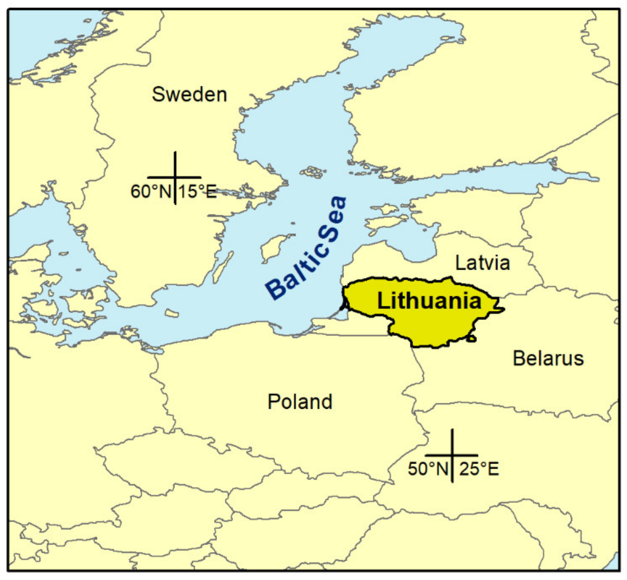
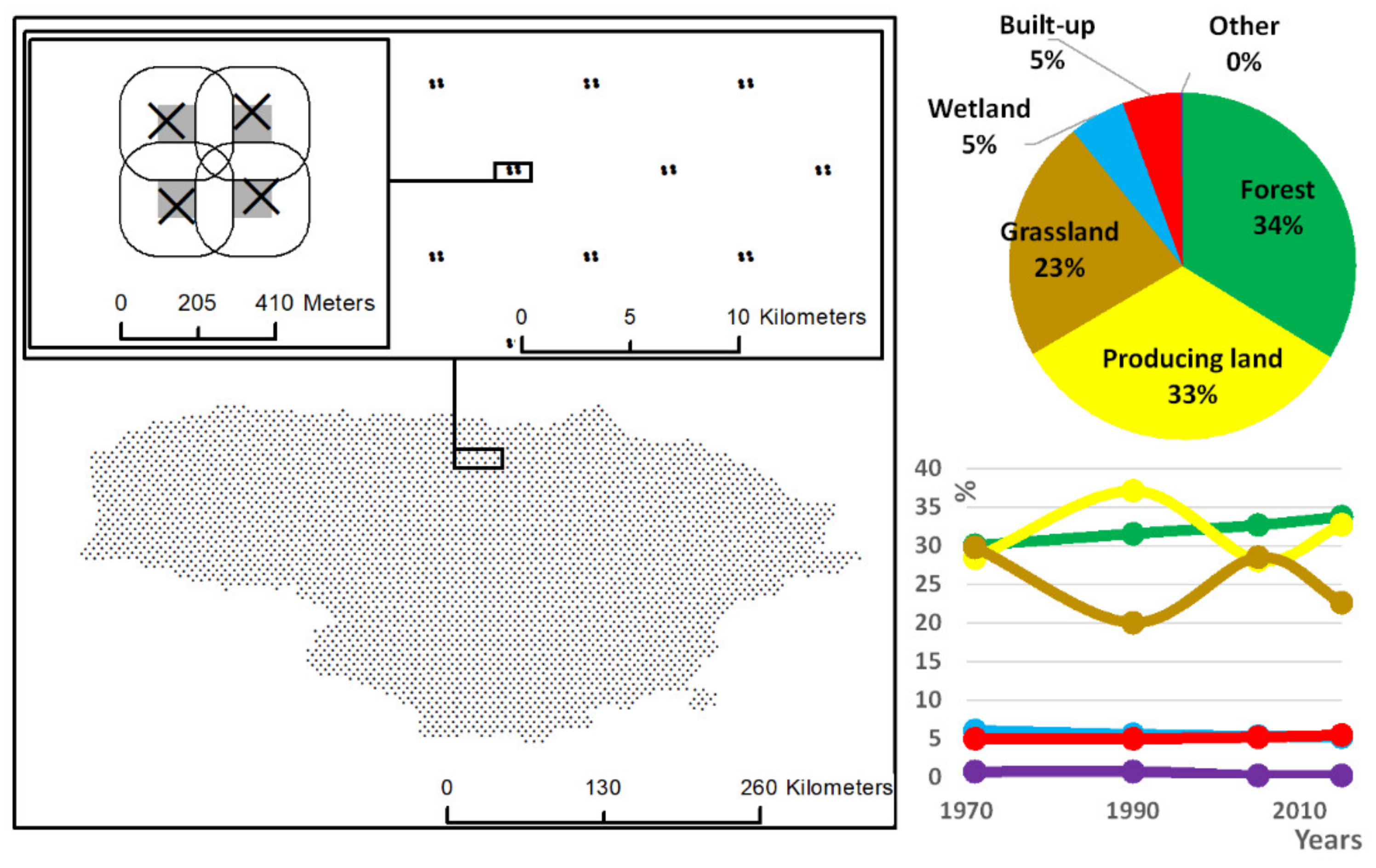
2.1. Study Area
2.2. Input Data
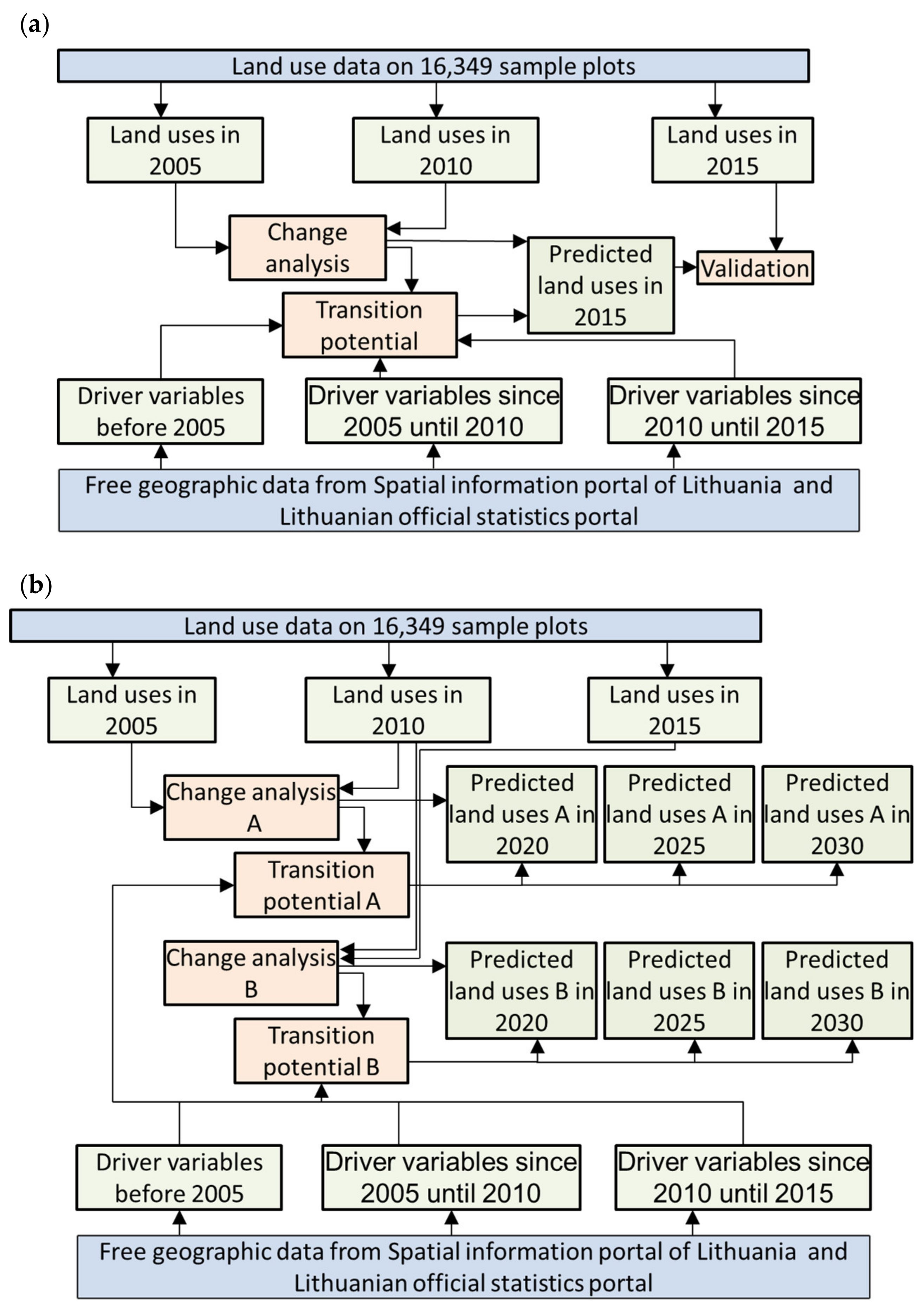
2.3. Modeling Land Use Development
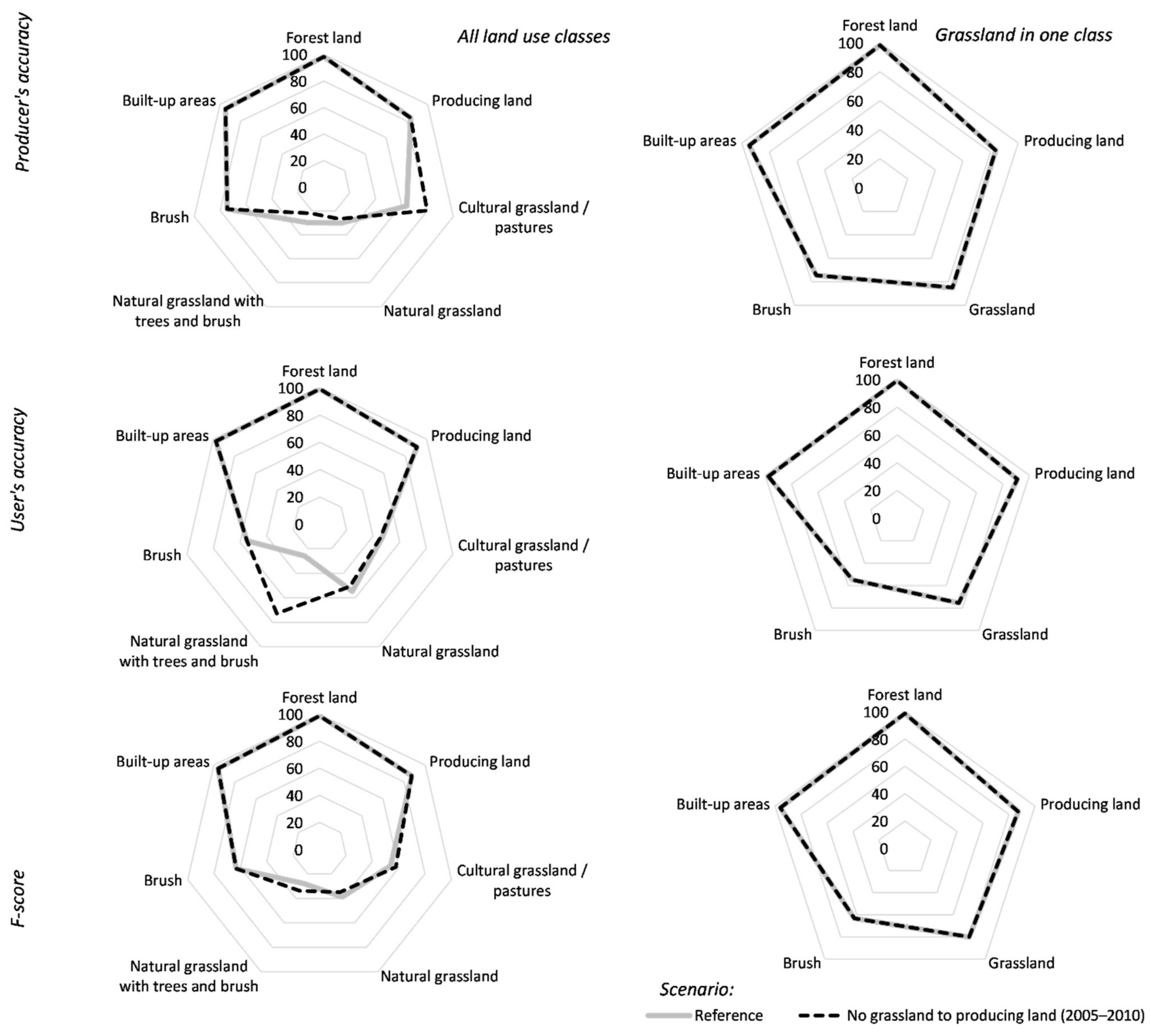
2.4. Validation Approaches
3. Results
3.1. Calibration and Validation of Land Use Change Models
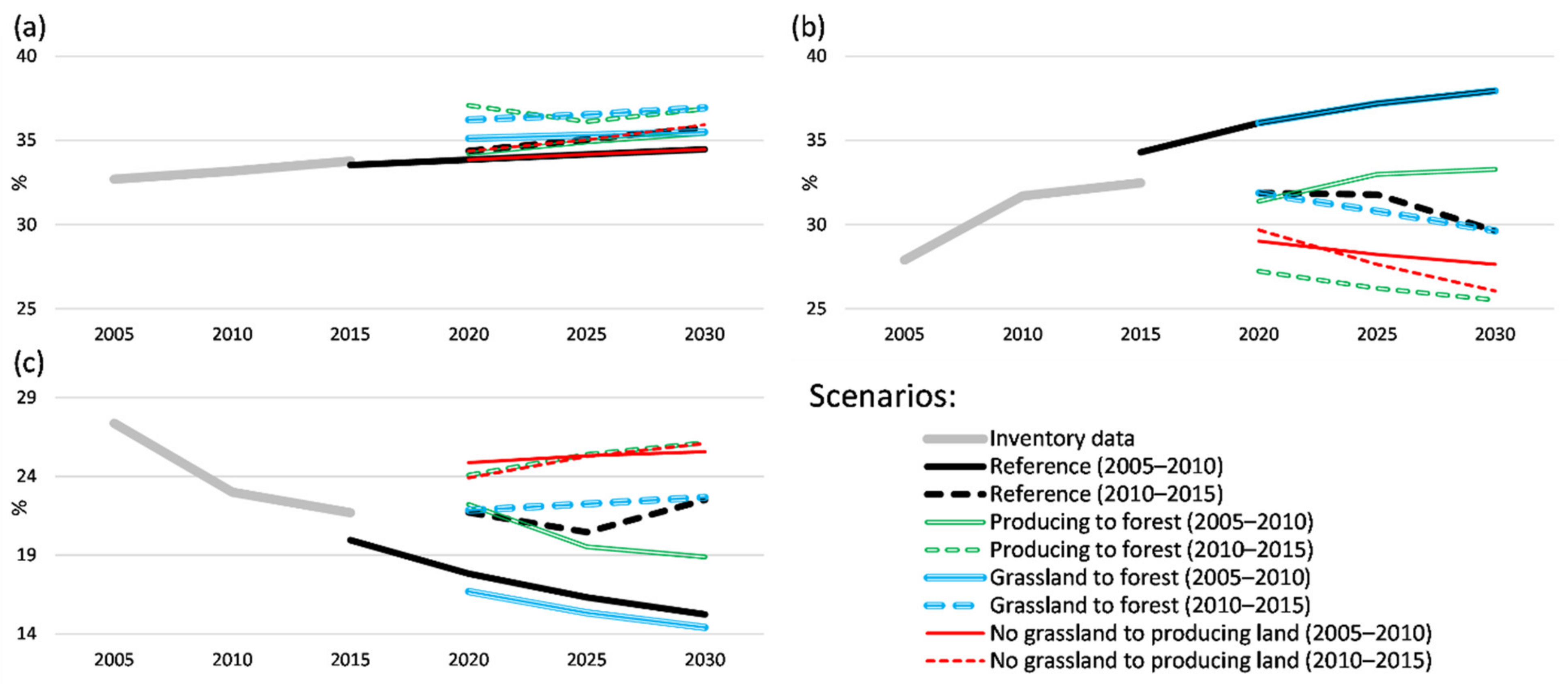
3.2. Land Use Changes in the Future
4. Discussion
5. Conclusions
Author Contributions
Funding
Institutional Review Board Statement
Informed Consent Statement
Data Availability Statement
Acknowledgments
Conflicts of Interest
Appendix A

| Land Use Subtype | Area Proportion in 2015 * |
|---|---|
| Forest land | 33.78 |
| Arable (producing) land | 32.49 |
| Cultural meadows and pastures | 11.44 |
| Natural grassland | 5.16 |
| Natural grassland covered by trees and brush | 5.06 |
| Cities, settlements and homesteads | 3.84 |
| Natural lakes and rivers | 3.02 |
| Roads and railways | 1.35 |
| Brush | 0.95 |
| Land reclamation ditches | 0.87 |
| Wetlands covered by trees and brush | 0.64 |
| Wetlands | 0.34 |
| Peat bogs | 0.34 |
| Orchards | 0.15 |
| Other built-up land | 0.15 |
| Routes and electricity lines | 0.10 |
| Queries | 0.10 |
| Berry fields | 0.08 |
| Other other land use | 0.07 |
| Other meadows and pastures | 0.02 |
| Other waters and wetlands | 0.02 |
| Short rotation plantations, willow plantations | 0.02 |
| Other producing land | 0.02 |
| Stony land | 0.01 |
| Description of the Variable | Source Database |
|---|---|
| Distance based variables | |
| Distance to the nearest agricultural block in KŽS. If the distance equals 0, then the plot is located in agricultural block | KŽS |
| Distance to the nearest built-up block in KŽS. If the distance equals 0, then the plot is located in built-up block | |
| Distance to the nearest miscellaneous block in KŽS (basically, forest). If the distance equals 0, then the plot is located in miscellaneous block | |
| Distance to the nearest road block in KŽS. If the distance equals 0, then the plot is located on the road | |
| Distance to the nearest block around linear hydrographic object in KŽS. If the distance equals 0, then the plot is located on the linear hydrographic object | |
| Distance to the nearest block around areal hydrographic object in KŽS. If the distance equals 0, then the plot is located on areal hydrographic object | |
| Area proportion-based variables | |
| Proportion of agricultural land in the zone around the NFI sample plot | |
| Proportion of built-up land in the zone around the NFI sample plot | KŽS |
| Proportion of miscellaneous land (basically, forest) in the zone around the NFI sample plot | |
| Proportion of land associated with the road blocks in the zone around the NFI sample plot | |
| Proportion of land associated with the blocks around linear hydrographic object in KŽS in the zone around the NFI sample plot | |
| Proportion of land associated with areal hydrographic object in KŽS in the zone around the NFI sample plot | |
| Proportion of land associated with the miscellaneous blocks with dominance of land not used for agriculture in KŽS in the zone around the NFI sample plot (for the period after 2010 only) | |
| Proportion of protected areas in the zone around the NFI sample plot | SŽNS_DR10LT |
| Proportion of nature heritage areas in the zone around the NFI sample plot | |
| Proportion of protective zones in the zone around the NFI sample plot | |
| Proportion of abandoned agricultural land in the zone around the NFI sample plot | AZ_DRLT |
| Variables available from land declaration data | |
| Proportion of producing land in the zone around the NFI sample plot | Spatial data set on the farmland, cropland and crop types |
| Proportion of berry-field land in the zone around the NFI sample plot | |
| Proportion of orchard land in the zone around the NFI sample plot | |
| Proportion of other producing land in the zone around the NFI sample plot | |
| Proportion of forest land in the zone around the NFI sample plot | |
| Proportion of pastures and meadows in the zone around the NFI sample plot | |
| Proportion of natural grassland in the zone around the NFI sample plot | |
| Proportion of other pastures and meadows in the zone around the NFI sample plot | |
| Proportion of waters and wetlands in the zone around the NFI sample plot | |
| Other variables | |
| Average soil productivity grade in the zone around the NFI sample plot | Dirv_DR10LT |
| Population density in 1 km2 cell, the NFI sample plot belongs to | Population and housing census 2011 |
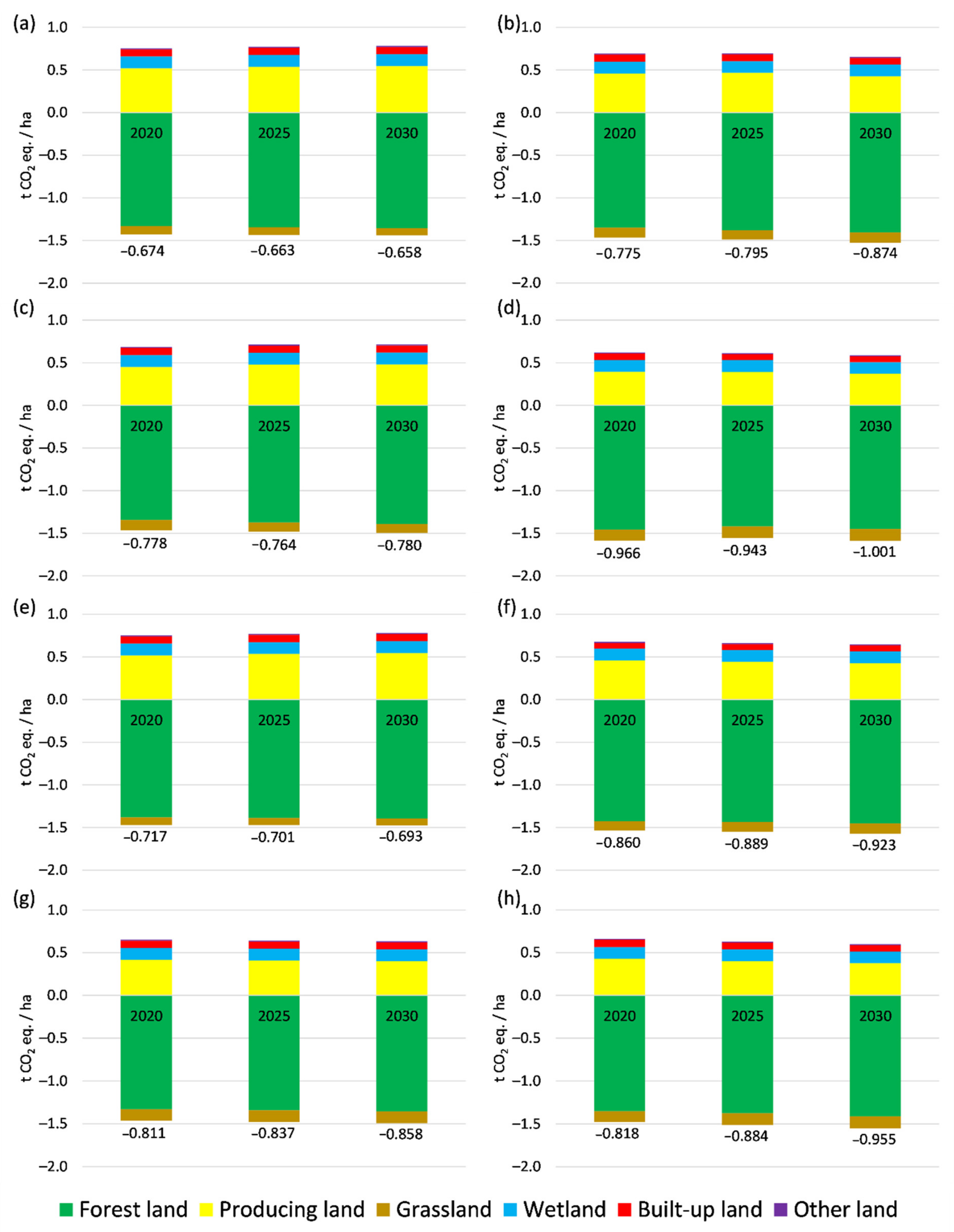
| Land Use Type | Prediction Years | |||||
|---|---|---|---|---|---|---|
| 2020 | 2025 | 2030 | 2020 | 2025 | 2030 | |
| Reference (2005–2010) | Reference (2010–2015) | |||||
| Forest land | −1.331 | −1.343 | −1.355 | −1.351 | −1.378 | −1.406 |
| Producing land | 0.519 | 0.535 | 0.546 | 0.460 | 0.468 | 0.428 |
| Grassland | −0.098 | −0.090 | −0.085 | −0.117 | −0.112 | −0.123 |
| Wetland | 0.139 | 0.139 | 0.139 | 0.138 | 0.134 | 0.138 |
| Built-up land | 0.084 | 0.084 | 0.084 | 0.083 | 0.080 | 0.077 |
| Other land | 0.013 | 0.013 | 0.013 | 0.011 | 0.011 | 0.011 |
| GHG balance in LULUCF sector | −0.674 | −0.662 | −0.658 | −0.775 | −0.795 | −0.874 |
| GHG balance in agricultural land | 0.421 | 0.445 | 0.461 | 0.343 | 0.357 | 0.305 |
| Producing land to forest (2005–2010) | Producing land to forest (2010–2015) | |||||
| Forest land | −1.345 | −1.372 | −1.392 | −1.458 | −1.419 | −1.449 |
| Producing land | 0.451 | 0.479 | 0.480 | 0.393 | 0.393 | 0.369 |
| Grassland | −0.120 | −0.107 | −0.103 | −0.128 | −0.136 | −0.140 |
| Wetland | 0.139 | 0.139 | 0.139 | 0.138 | 0.138 | 0.138 |
| Built-up land | 0.084 | 0.084 | 0.084 | 0.078 | 0.070 | 0.071 |
| Other land | 0.013 | 0.013 | 0.013 | 0.011 | 0.011 | 0.011 |
| GHG balance in LULUCF sector | −0.778 | −0.764 | −0.780 | −0.966 | −0.943 | −1.001 |
| GHG balance in agricultural land | 0.331 | 0.372 | 0.377 | 0.265 | 0.257 | 0.228 |
| Grassland to forest (2005–2010) | Grassland to forest (2010–2015) | |||||
| Forest land | −1.380 | −1.388 | −1.395 | −1.424 | −1.436 | −1.452 |
| Producing land | 0.519 | 0.535 | 0.546 | 0.460 | 0.444 | 0.428 |
| Grassland | −0.091 | −0.084 | −0.080 | −0.112 | −0.116 | −0.119 |
| Wetland | 0.139 | 0.139 | 0.139 | 0.138 | 0.138 | 0.138 |
| Built-up land | 0.084 | 0.084 | 0.084 | 0.067 | 0.069 | 0.071 |
| Other land | 0.013 | 0.013 | 0.013 | 0.011 | 0.011 | 0.011 |
| GHG balance in LULUCF sector | −0.717 | −0.701 | −0.693 | −0.860 | −0.889 | −0.923 |
| GHG balance in agricultural land | 0.427 | 0.451 | 0.466 | 0.348 | 0.329 | 0.309 |
| No grassland to producing land (2005–2010) | No grassland to producing land (2010–2015) | |||||
| Forest land | −1.331 | −1.343 | −1.355 | −1.351 | −1.377 | −1.412 |
| Producing land | 0.418 | 0.407 | 0.399 | 0.428 | 0.399 | 0.376 |
| Grassland | −0.134 | −0.136 | −0.137 | −0.128 | −0.136 | −0.141 |
| Wetland | 0.139 | 0.139 | 0.139 | 0.138 | 0.138 | 0.134 |
| Built-up land | 0.084 | 0.084 | 0.084 | 0.083 | 0.080 | 0.077 |
| Other land | 0.013 | 0.013 | 0.013 | 0.011 | 0.011 | 0.011 |
| GHG balance in LULUCF sector | −0.811 | −0.837 | −0.858 | −0.818 | −0.884 | −0.955 |
| GHG balance in agricultural land | 0.285 | 0.271 | 0.261 | 0.300 | 0.263 | 0.235 |
References
- IPCC. Summary for Policymakers. In Climate Change 2014: Synthesis Report. Contribution of Working Groups I, II and III to the Fifth Assessment Report of the Intergovernmental Panel on Climate Change; Core Writing Team, Pachauri, R.K., Meyer, L.A., Eds.; IPCC: Geneva, Switzerland, 2014; 151p. [Google Scholar]
- Deemer, B.R.; Harrison, J.A.; Li, S.; Beaulieu, J.J.; DelSontro, T.; Barros, N.; Bezerra-Neto, J.F.; Powers, S.M.; Dos Santos, M.A.; Vonk, J.A. Greenhouse Gas Emissions from Reservoir Water Surfaces: A New Global Synthesis. Bioscience 2016, 66, 949–964. [Google Scholar] [CrossRef] [PubMed]
- Frank, D.; Esper, J.; Raible, C.C.; Büntgen, U.; Trouet, V.; Stocker, B.; Joos, F. Ensemble reconstruction constraints on the global carbon cycle sensitivity to climate. Nature 2010, 463, 527–530. [Google Scholar] [CrossRef]
- Fleurbaey, M.; Edenhofer, O.; Pichs-Madruga, Y.; Sokona, E.; Farahani, S.; Kadner, P.E.K.; Seyboth, A.; Adler, I.; Baum, S.; Brunner, T.Z.J.C.M.; et al. (Eds.) Sustainable Development and Equity. In Climate Change 2014: Mitigation of Climate Change. Contribution of Working Group III to the Fifth Assessment Report of the Intergovernmental Panel on Climate Change; Cambridge University Press: Cambridge, UK; New York, NY, USA, 2014; pp. 283–350. [Google Scholar]
- Holland, E.A.; Braswell, B.H.; Lamarque, J.F.; Townsend, A.; Sulzman, J.; Mtiller, J.F.; Dentener, F.; Brasseur, G.; Levy, H.; Penner, J.E.; et al. Variations in the predicted spatial distribution of atmospheric nitrogen deposition and their impact on carbon uptake by terrestrial ecosystems. J. Geophys. Res. 1997, 102, 15849–15866. [Google Scholar] [CrossRef]
- Houghton, J.T.; Ding, Y.; Griggs, D.J.; Noguer, M.; van der Linden, P.J.; Dai, X.; Maskell, K.; Johnson, C.A. (Eds.) Climate Change 2001: The Scientific Basis; Cambridge University Press: Cambridge, UK, 2001. [Google Scholar]
- Friedlingstein, P.; Cox, P.; Betts, R.; Bopp, L.; Von Bloh, W.; Brovkin, V.; Cadule, P.; Doney, S.; Eby, M.; Fung, I.; et al. Climate–Carbon Cycle Feedback Analysis: Results from the C4MIP Model Intercomparison. J. Clim. 2006, 19, 3337–3353. [Google Scholar] [CrossRef]
- Raupach, M.R.; Marland, G.; Ciais, P.; Le Quéré, C.; Canadell, J.G.; Klepper, G.; Field, C.B. Global and regional drivers of accelerating CO2 emissions. Proc. Natl. Acad. Sci. USA 2007, 104, 10288–10293. [Google Scholar] [CrossRef] [PubMed] [Green Version]
- Cox, P.; Jones, C. Climate change—Illuminating the modern dance of climate and CO2. Science 2008, 321, 1642–1644. [Google Scholar] [CrossRef]
- Leung, D.Y.C.; Caramanna, G.; Maroto-Valer, M.M. An overview of current status of carbon dioxide capture and storage technologies. Renew. Sustain. Energy Rev. 2014, 39, 426–443. [Google Scholar] [CrossRef] [Green Version]
- Cuéllar-Franca, R.M.; Azapagic, A. Carbon capture, storage and utilisation technologies: A critical analysis and comparison of their life cycle environmental impacts. J. CO2 Util. 2019, 9, 82–102. [Google Scholar] [CrossRef]
- IPCC. 2006 IPCC Guidelines for National Greenhouse Gas Inventories; Prepared by the National Greenhouse Gas Inventories Programme; Eggleston, H.S., Buendia, L., Miwa, K., Ngara, T., Tanabe, K., Eds.; IGES: Tokyo, Japan, 2006. [Google Scholar]
- European Parliament and Council. Regulation (EU) 2018/841 of the European Parliament and of the Council of 30 May 2018 on the Inclusion of Greenhouse Gas Emissions and Removals from Land Use, Land Use Change and Forestry in the 2030 Climate and energy Framework, and Amending Regulation (EU) No 525/2013 and Decision No 529/2013/EU. Available online: https://eur-lex.europa.eu/legal-content/EN/TXT/?uri=uriserv:OJ.L_.2018.156.01.0001.01.ENG (accessed on 27 December 2020).
- European Parliament and Council. Regulation (EU) 2018/842 of the European Parliament and of the Council of 30 May 2018 on Binding Annual Greenhouse Gas Emission Reductions by Member States from 2021 to 2030 Contributing to Climate Action to Meet Commitments under the Paris Agreement and amending Regulation (EU) No 525/2013. Available online: https://eur-lex.europa.eu/legal-content/EN/TXT/?uri=celex%3A32018R0842 (accessed on 27 December 2020).
- Schaldach, R.; Priess, A. Integrated Models of the Land System: A Review of Modeling Approaches on the Regional to Global Scale. Living Rev. Landsc. Res. 2008, 2, 1–34. [Google Scholar] [CrossRef] [Green Version]
- Wang, S.H.; Huang, S.L.; William, W.; Budd, W.W. Integrated ecosystem model for simulating land use allocation. Ecol. Model. 2012, 227, 46–55. [Google Scholar] [CrossRef]
- Haase, D.; Schwarz, N. Simulation Models on Human—Nature Interactions in Urban Landscapes: A Review Including Spatial Economics, System Dynamics, Cellular Automata and Agent-based Approaches. Living Rev. Landsc. Res. 2009, 3, 2. [Google Scholar] [CrossRef]
- Sangermano, F.; Eastman, J.R.; Zhu, H. Similarity Weighted Instance-based Learning for the Generation of Transition Potentials in Land Use Change Modeling. Trans. GIS 2010, 14, 569–580. [Google Scholar] [CrossRef]
- Batty, M. Geocomputation using cellular automata. In Geocomputation; Openshaw, S., Abrahart, R., Eds.; Taylor and Francis: London, UK, 2000; pp. 95–126. [Google Scholar]
- De Almeida, C.M.; Batty, M.; Monteiro, A.M.V.; Câmara, G.; Soares-Filho, B.S.; Cerqueira, G.C.; Pennachin, C.L. Stochastic cellular automata modeling of urban land use dynamics: Empirical development and estimation. Comput. Environ. Urban Syst. 2003, 27, 481–509. [Google Scholar] [CrossRef]
- Parker, D.C.; Manson, S.M.; Janssen, M.A.; Hoffmann, M.J.; Deadman, P. Multi-Agent Systems for the Simulation of Land-Use and Land-Cover Change: A Review. Ann. Assoc. Am. Geogr. 2003, 93, 314–337. [Google Scholar] [CrossRef] [Green Version]
- Reisinger, A.; Havlík, P.; Riahi, K.; Van Vliet, O.; Obersteiner, M.; Herrero, M. Implications of alternative metrics for global mitigation costs and greenhouse gas emissions from agriculture. Clim. Chang. 2012. [Google Scholar] [CrossRef]
- Oliver, T.H.; Morecroft, M.D. Interactions between climate change and land use change on biodiversity: Attribution problems, risks, and opportunities. Wiley Interdiscip. Rev. Clim. Chang. 2014, 5, 317–335. [Google Scholar] [CrossRef] [Green Version]
- Kuramochi, T.; Höhne, N.; Schaeffer, M.; Cantzler, J.; Hare, B.; Deng, Y.; Sterl, S.; Hagemann, M.; Rocha, M.; Yanguas-Parra, P.A.; et al. Ten key short-term sectoral benchmarks to limit warming to 1.5 °C. Clim. Policy 2017, 18, 287–305. [Google Scholar] [CrossRef]
- Riahi, K.; Kriegler, E.; Johnson, N.; Bertram, C.; Den Elzen, M.; Eom, J.; Schaeffer, M.; Edmonds, J.; Isaac, M.; Krey, V.; et al. Locked into Copenhagen pledges—Implications of shortterm emission targets for the cost and feasibility of long-term climate goals. Technol. Forecast. Soc. Chang. 2015, 90 Pt A, 8–23. [Google Scholar] [CrossRef]
- Rogelj, J.; Popp, A.; Calvin, K.V.; Luderer, G.; Emmerling, J.; Gernaat, D.; Fujimori, S.; Strefler, J. Scenarios towards limiting global mean temperature increase below 1.5 °C. Nat. Clim. Chang. 2018, 8, 325–332. [Google Scholar] [CrossRef]
- Dzieszko, P. Land-cover modelling using CORINE Land Cover data and multi-layer perceptron. Quaest. Geogr. 2014, 33, 5–22. [Google Scholar] [CrossRef] [Green Version]
- Konstantinavičiūtė, I.; Byčenkienė, S.; Kavšinė, A.; Zaikova, I.; Juška, R.; Žiukelytė, I.; Lenkaitis, R.; Kazanavičiūtė, V.; Mačiulskas, M.; Juraitė, T.; et al. Lithuania’s National Inventory Report 2018: Greenhouse Gas Emissions 1990–2016. Ministry of Environment, Environmental Protection Agency; State Forest Service: Vilnius, Lithuania, 2018; p. 617. Available online: https://am.lrv.lt/uploads/am/documents/files/%C5%A0ESD%20apskaitos%20ir%20kt%20ataskaitos/LT_NIR_FINAL_2018.pdf (accessed on 9 November 2020).
- Kulbokas, G.; Jurevičienė, V.; Kuliešis, A.; Augustaitis, A.; Petrauskas, E.; Mikalajūnas, M.; Vitas, A.; Mozgeris, G. Fluctuations in gross volume increment estimated by the Lithuanian National Forest Inventory compared with annual variations in single tree increment. Balt. For. 2019, 25, 105–112. [Google Scholar] [CrossRef]
- Barreiro, S.; Schelhaas, M.-J.; Kändler, G.; Antón-Fernández, C.; Colin, A.; Bontemps, J.-D.; Alberdi, I.; Condés, S.; Dumitru, M.; Ferezliev, A.; et al. Overview of methods and tools for evaluating future woody biomass availability in European countries. Ann. For. Sci. 2016, 73, 823–837. [Google Scholar] [CrossRef] [Green Version]
- Orazio, C.; Montoya, R.C.; Régolini, M.; Borges, J.G.; Garcia-Gonzalo, J.; Barreiro, S.; Botequim, B.; Marques, S.; Sedmák, R.; Smreček, R.; et al. Decision Support Tools and Strategies to Simulate Forest Landscape Evolutions Integrating Forest Owner Behaviour: A Review from the Case Studies of the European Project, INTEGRAL. Sustainability 2017, 9, 599. [Google Scholar] [CrossRef] [Green Version]
- Mozgeris, G.; Brukas, V.; Pivoriūnas, N.; Činga, G.; Makrickiene, E.; Byčenkienė, S.; Marozas, V.; Mikalajūnas, M.; Dudoitis, V.; Ulevičius, V.; et al. Spatial pattern of climate change effects on Lithuanian forestry. Forests 2019, 10, 809. [Google Scholar] [CrossRef] [Green Version]
- Packalen, T.; Sallnäs, O.; Sirkiä, S.; Korhonen, K.; Salminen, O.; Vidal, C.; Robert, N.; Colin, A.; Belouard, T.; Schadauer, K.; et al. The European Forestry Dynamics Model: Concept, Design and Results of First Case Studies; EUR 27004; Publications Office of the European Union: Luxembourg, 2014. [Google Scholar] [CrossRef]
- Konstantinavičiūtė, I.; Miškinis, V.; Galinis, A.; Lekavičius, V.; Tarvydas, D.; Norvaiša, E.; Pažėraitė, A.; Bobinaitė, V.; Gatautis, R.; Alėbaitė, I.; et al. Nacionalinių Išmetamų į Atmosferą Šiltnamio Efektą Sukeliančių Dujų Kiekio Prognozių Rengimo Metodinių Gairių Parengimas: Galutinė Ataskaita; Lietuvos Energetikos Institutas: Kaunas, Lithuania, 2016. [Google Scholar]
- Juknelienė, D.; Valčiukienė, J.; Atkocevičienė, V. Assessment of regulation of legal relations of territorial planning: A case study in Lithuania. Land Use Policy 2017, 67, 65–72. [Google Scholar] [CrossRef]
- Kuliešis, A.; Kasperavičius, A.; Kulbokas, G. Lithuania (Book Chapter). National Forest Inventories—Assessment of Wood Availability and Use; Vidal, C., Alberdi, I., Hernandez, L., Redmond, J., Eds.; Springer International Publishing: Cham, Switzerland, 2016; Chapter 28; pp. 521–547. [Google Scholar]
- IPCC. Good Practice Guidance for Land Use, Land-Use Change and Forestry; Institute for Global Environmental Strategies: Kanagawa, Japan, 2003. [Google Scholar]
- Eastman, J.R. TerrSet Manual; Clark University: Worcester, MA, USA, 2015; 394p, Available online: www.clarklabs.org (accessed on 3 January 2021).
- Lithuania‘s National Inventory Report 2018. Greenhouse Gas Emissions 1990–2016. Vilnius, Lithuania. 2018. Available online: https://klimatas.gamta.lt/files/LT_NIR_20180415_final.pdf (accessed on 3 January 2021).
- Landis, J.R.; Koch, G. The measurement of observer agreement for categorical data. Biometrics 1977, 33, 159–174. [Google Scholar] [CrossRef] [PubMed] [Green Version]
- Congalton, R.G.; Green, K. Assesing the Accuracy of Remotely Sensed Data—Principles and Practices; CRC Press: Boca Raton, FL, USA, 1999. [Google Scholar]
- Soares-Filho, B.S.; Cerqueira, G.C.; Pennachin, C.L. Dinamica—A stochastic cellular automata model designed to simulate the landscape dynamics in an Amazonian colonization frontier. Ecol. Model. 2002, 154, 217–235. [Google Scholar] [CrossRef]
- Pontius, R.G.; Schneider, L.C. Land-cover change model validation by a ROC method. Agric. Ecosyst. Environ. 2001, 85, 239–248. [Google Scholar] [CrossRef]
- Verburg, P.; De Koning, G.; Kok, K.; Veldkamp, A.; Bouma, J. A spatial explicit allocation procedure for modelling the pattern of land use change based upon actual land use. Ecol. Model. 1999, 116, 45–61. [Google Scholar] [CrossRef]
- Pijanowski, B.C.; Brown, D.G.; Shellito, B.A.; Manik, G.A. Using neural networks and GIS to forecast land use changes: A Land Transformation Model. Comput. Environ. Urban Syst. 2002, 26, 553–575. [Google Scholar] [CrossRef]
- Juknelienė, D.; Mozgeris, G. The spatial pattern of forest cover changes in Lithuania during the second half of the twentieth century. Žemės ūkio Mokslai 2015, 22, 209–215. [Google Scholar] [CrossRef] [Green Version]
- Lithuania’s National Inventory Report 2021. Greenhouse Gas Emissions 1990–2019. Draft. 2021. Available online: https://am.lrv.lt/uploads/am/documents/files/KLIMATO%20KAITA/%C5%A0ESD%20apskaitos%20ir%20kt%20ataskaitos/NIR_2021_01_15%20FINAL.pdf (accessed on 10 January 2021).
- Estel, S.; Mader, S.; Levers, C.; Verburg, P.H.; Baumann, M.; Kuemmerle, T. Combining satellite data and agricultural statistics to map grassland management intensity in Europe. Environ. Res. Lett. 2018, 13, 074020. [Google Scholar] [CrossRef]
- Lithuanian Statistical Yearbook of Forestry. Ministry of Environment, State Forest Service. 2019. Available online: http://www.amvmt.lt/index.php/leidiniai/misku-ukio-statistika/2019 (accessed on 14 January 2021).
- Lietuvos Respublikos Teritorijos Bendrasis Planas. Konkretizuoti Sprendiniai: Teritotinių Elementų Vystymas. Available online: http://www.bendrasisplanas.lt/wp-content/uploads/2020/07/LR-BP-Teritorini%C5%B3-element%C5%B3-vystymas.pdf (accessed on 14 January 2021).
- Decision No. 569. 2012. Available online: https://e-seimas.lrs.lt/portal/legalAct/lt/TAD/TAIS.425608 (accessed on 22 January 2021).
- Order No. D1-199. 2008. Available online: https://www.e-tar.lt/portal/lt/legalAct/TAR.E0061030F4E1/asr (accessed on 22 January 2021).
- Decision No. 1131. 2011. Available online: https://e-seimas.lrs.lt/portal/legalAct/lt/TAD/TAIS.407618?jfwid=-1n2mj1nis (accessed on 22 January 2021).
- Lietuvos 2007–2013 m. Kaimo Plėtros Programa: Europos Komisija, 2007 m. rugsėjo 19 d. Nr.1698/2005. Available online: https://zum.lrv.lt/uploads/zum/documents/files/LT_versija/Veiklos_sritys/Kaimo_pletra/Lietuvos_kaimo_pletros_2007%E2%80%932013%20m._programa/KPP20072013LT20141222.pdf (accessed on 22 January 2021).
- Lietuvos 2014–2020 m. Kaimo Plėtros Programa. Europos Komisija, 2015 m. vasario 13 d.Nr. C(2015)842. Available online: https://ec.europa.eu/info/sites/info/files/food-farming-fisheries/key_policies/documents/rdp-lithuanua-fulltext_lt.pdf (accessed on 22 January 2021).
- European Parliament and Council. Regulation (EU) No 1307/2013 of the European Parliament and of the Council of 17 December 2013 Establishing Rules for Direct Payments to Farmers under Support Schemes within the Framework of the Common Agricultural Policy and Repealing Council Regulation (EC) No 637/2008 and Council Regulation (EC) No 73/2009. Available online: http://data.europa.eu/eli/reg/2013/1307/oj (accessed on 14 January 2021).
| Strategy of Using Driver Variables | Versions of KŽS | AZ_DRLT, SŽNS_DR10LT, Dirv_DR10LT, and Census Data | Land Use Declaration Data | Optimization of Explanatory Variables | ||
|---|---|---|---|---|---|---|
| Before 2005 | Between 2005 and 2010 | After 2010 | ||||
| 1 | + | + | ||||
| 2 | + | + | + | |||
| 3 | + | + | + | |||
| 4 | + | + | + | + | ||
| 5 | + | + | + | + | + | |
| 6 | + | + | + | + | + | + |
| Scenario Title | Main Features for Building the Markov Matrix | |
|---|---|---|
| Period | Manual Transformations of Transition Probabilities | |
| Reference (2005–2010) | 2005–2010 | - |
| Reference (2010–2015) | 2010–2015 | |
| Producing land to forest (2005–2010) | 2005–2010 | The probability of transformation of the following land into the forest is doubled: arable land, natural grassland with trees and brush, brush |
| Producing land to forest (2010–2015) | 2010–2015 | The probability of transformation of arable land into cultural grassland and pastures is doubled, and the remaining natural grassland with trees and brush is transformed into cultural grassland and pastures |
| Grassland to forest (2005–2010) | 2005–2010 | All natural grasslands with trees and shrubs are transformed into forest land. |
| Grassland to forest (2010–2015) | 2010–2015 | |
| No grassland to producing land (2005–2010) | 2005–2010 | There is no transformation of grassland/pasture land into producing land, and all other land use changes follow trends during the reference period |
| No grassland to producing land (2010–2015) | 2010–2015 | |
| Strategy of Using Driver Variables | All Land Use Subtypes | Grasslands Merged into One Class | Z Statistics | ||
|---|---|---|---|---|---|
| Overall Prediction Accuracy | Kappa | Overall Prediction Accuracy | Kappa | ||
| Scenario: Reference | |||||
| 1 | 81.9 | 0.76 | 87.7 | 0.83 | 1.296 * |
| 2 | 82.1 | 0.76 | 88.0 | 0.84 | 1.310 * |
| 3 | 82.2 | 0.76 | 88.3 | 0.84 | 1.361 * |
| 4 | 82.1 | 0.76 | 88.2 | 0.84 | 1.369 * |
| 5 | 82.8 | 0.77 | 88.6 | 0.84 | 1.295 * |
| 6 | 81.9 | 0.76 | 88.9 | 0.86 | 1.783 * |
| Scenario: No grassland to producing land (2005–2010) | |||||
| 1 | 82.8 | 0.77 | 89.5 | 0.86 | 0.268/0.467 ** |
| 2 | 82.9 | 0.77 | 89.6 | 0.86 | 0.228/0.414 ** |
| 3 | 83.0 | 0.78 | 89.8 | 0.86 | 0.248/0.394 ** |
| 4 | 82.8 | 0.77 | 89.5 | 0.86 | 0.235/0.349 ** |
| 5 | 83.1 | 0.78 | 89.7 | 0.86 | 0.112/0.292 ** |
| 6 | 83.1 | 0.78 | 89.8 | 0.86 | 0.254/−0.022 ** |
Publisher’s Note: MDPI stays neutral with regard to jurisdictional claims in published maps and institutional affiliations. |
© 2021 by the authors. Licensee MDPI, Basel, Switzerland. This article is an open access article distributed under the terms and conditions of the Creative Commons Attribution (CC BY) license (http://creativecommons.org/licenses/by/4.0/).
Share and Cite
Mozgeris, G.; Juknelienė, D. Modeling Future Land Use Development: A Lithuanian Case. Land 2021, 10, 360. https://doi.org/10.3390/land10040360
Mozgeris G, Juknelienė D. Modeling Future Land Use Development: A Lithuanian Case. Land. 2021; 10(4):360. https://doi.org/10.3390/land10040360
Chicago/Turabian StyleMozgeris, Gintautas, and Daiva Juknelienė. 2021. "Modeling Future Land Use Development: A Lithuanian Case" Land 10, no. 4: 360. https://doi.org/10.3390/land10040360
APA StyleMozgeris, G., & Juknelienė, D. (2021). Modeling Future Land Use Development: A Lithuanian Case. Land, 10(4), 360. https://doi.org/10.3390/land10040360