
Determinants of the Land Registration Information System Operational Success: Empirical Evidence from Ethiopia

Abstract
1. Introduction
2. Literature Review
2.1. Land Tenure and Registration in Ethiopia
2.2. Land Information System in Ethiopia
3. Theoretical Base
4. Materials and Methods
4.1. Study Site
4.2. Sampling Method
4.3. Sample Size
5. Results
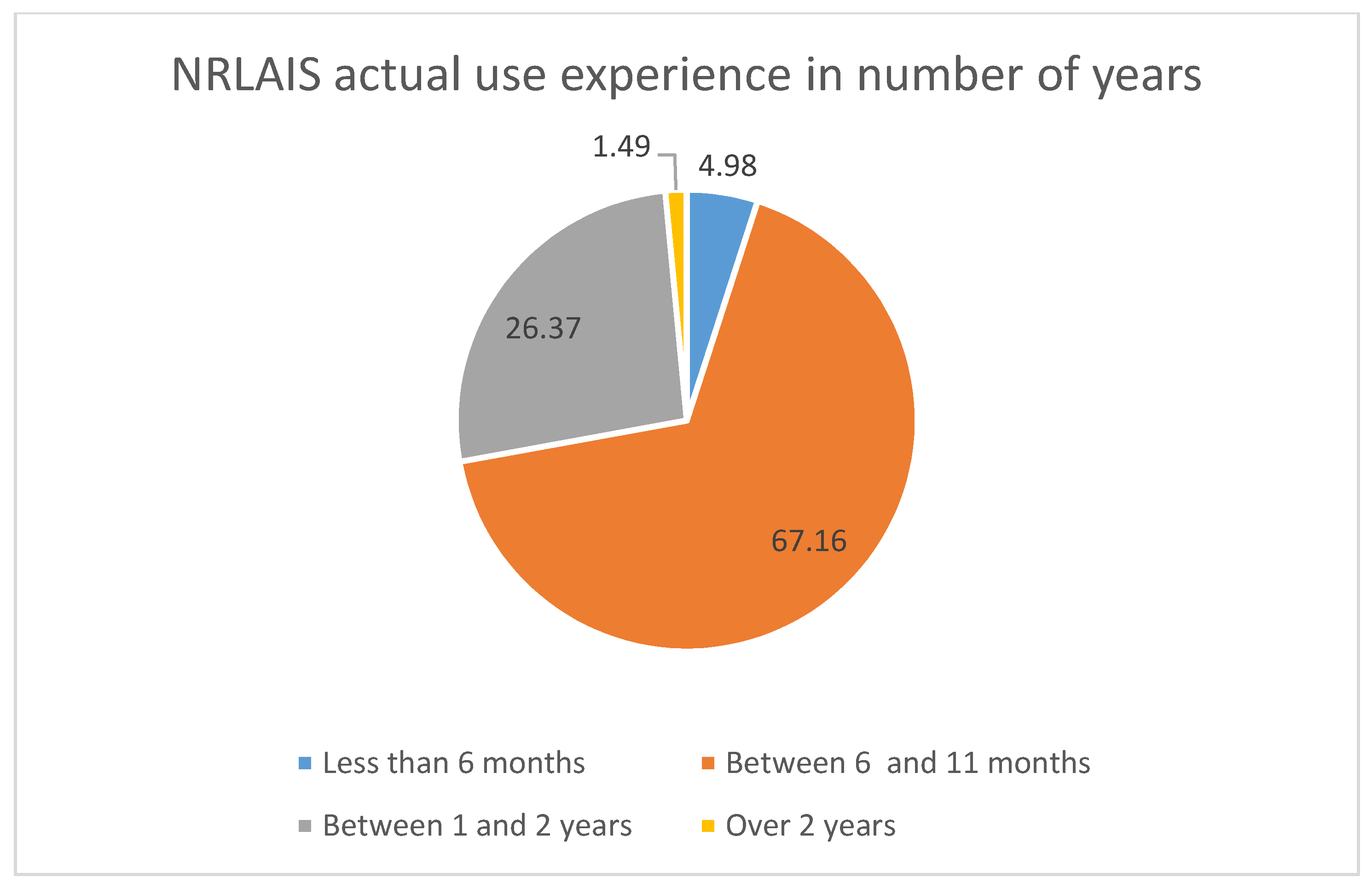
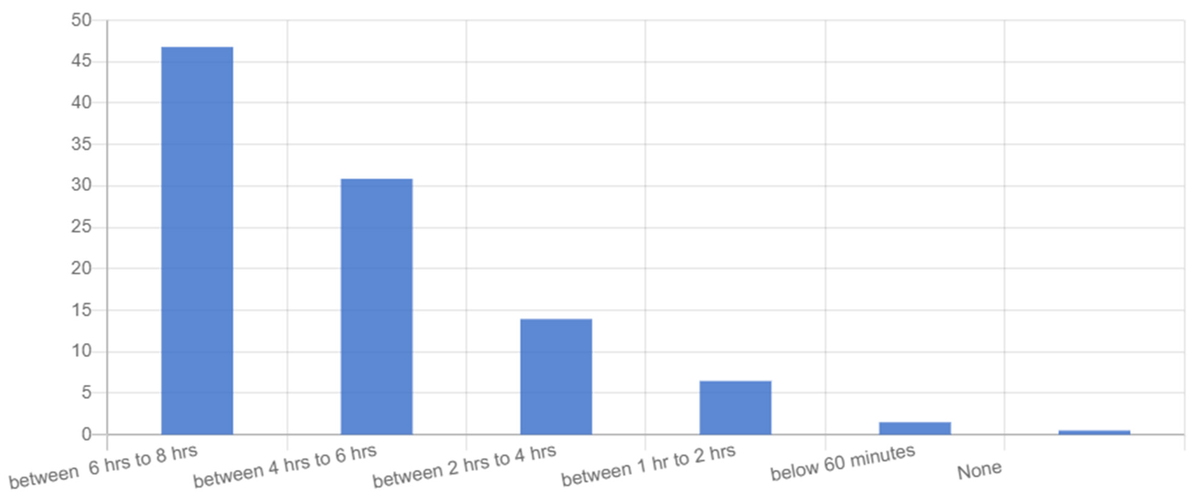
5.1. Characteristics of Respondents
5.2. Validity and Reliability
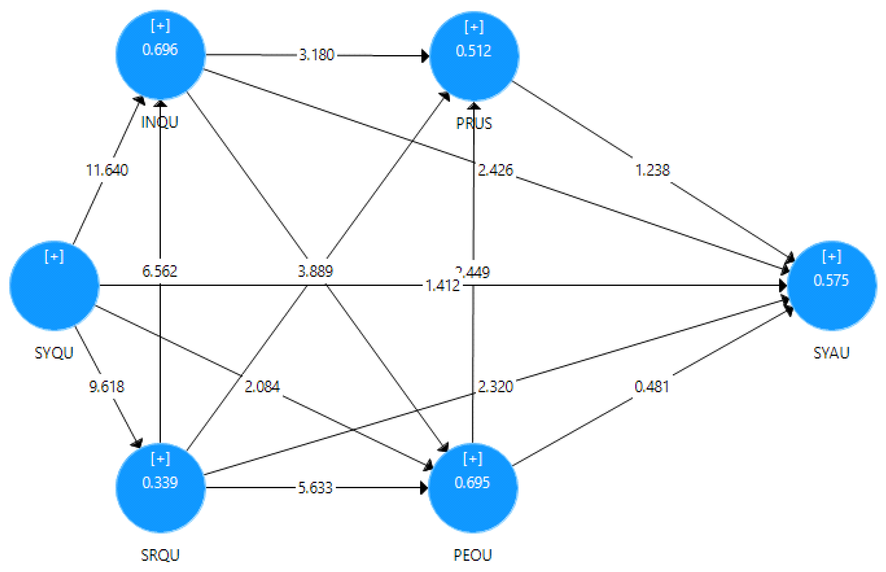
5.3. Structural Model (Inner Model) Analysis
5.4. Mediation Analysis
6. Discussion
7. Conclusions
Author Contributions
Funding
Institutional Review Board Statement
Informed Consent Statement
Data Availability Statement
Acknowledgments
Conflicts of Interest
References
- Bennett, R.M.; Unger, E.M.; Lemmen, C.; Dijkstra, P. Land administration maintenance: A review of the persistent problem and emerging fit-for-purpose solutions. Land 2021, 10, 509. [Google Scholar] [CrossRef]
- Framework for Effective Land Administration Expert Group on Land Administration and Management United Nations Committee of Experts on Global Geospatial Information Management (UN-GGIM) Content. 2020. Available online: https://ggim.un.org/meetings/GGIM-committee/10th-Session/documents/E-C.20-2020-29-Add_2-Framework-for-Effective-Land-Administration.pdf (accessed on 23 September 2021).
- Masuda, Y.J.; Kelly, A.C.; Robinson, B.E.; Holland, M.B.; Bedford, C.; Childress, M.; Game, E.T.; Ginsburg, C.; Hilhorst, T.; Lawry, S.W.; et al. How do practitioners characterize land tenure security? Conserv. Sci. Pract. 2020, 2, e186. [Google Scholar] [CrossRef]
- Byamugisha, F.F.K. Experiences and development impacts of securing land rights at scale in developing countries: Case studies of China and Vietnam. Land 2021, 10, 176. [Google Scholar] [CrossRef]
- Mitchell, D.; Barth, B.; Ho, S.; Sait, M.S.; McEvoy, D. The benefits of fit-for-purpose land administration for urban community resilience in a time of climate change and COVID-19 pandemic. Land 2021, 10, 563. [Google Scholar] [CrossRef]
- Singirankabo, U.A.; Ertsen, M.W. Relations between land tenure security and agricultural productivity: Exploring the effect of land registration. Land 2020, 9, 138. [Google Scholar] [CrossRef]
- Krigsholm, P.; Riekkinen, K.; Ståhle, P. The changing uses of cadastral information: A user-driven case study. Land 2018, 7, 83. [Google Scholar] [CrossRef]
- McLain, R.; Lawry, S.; Guariguata, M.R.; Reed, J. Toward a tenure-responsive approach to forest landscape restoration: A proposed tenure diagnostic for assessing restoration opportunities. Land Use Policy 2021, 104, 103748. [Google Scholar] [CrossRef]
- Lawry, S.; Samii, C.; Hall, R.; Leopold, A.; Hornby, D.; Mtero, F. The impact of land property rights interventions on investment and agricultural productivity in developing countries: A systematic review. J. Dev. Eff. 2017, 9, 61–81. [Google Scholar] [CrossRef]
- Schwartz, M.W.; Cook, C.N.; Pressey, R.L.; Pullin, A.S.; Runge, M.C.; Salafsky, N.; Sutherland, W.J.; Williamson, M.A. Decision Support Frameworks and Tools for Conservation. Conserv. Lett. 2018, 11, e12385. [Google Scholar] [CrossRef]
- Ingram, G.K.; Hong, Y. Property Rights and Land Policies; Lincoln Institute of Land Policy: Cambridge, MA, USA, 2009; ISBN 9781558441880. [Google Scholar]
- Jing, Y.; Bennett, R.; Zevenbergen, J. Up-to-dateness in land administration: Setting the record straight. Coordinates 2014, 10, 37–42. [Google Scholar]
- Biraro, M.; Zevenbergen, J.; Alemie, B.K. Good practices in updating land information systems that used unconventional approaches in systematic land registration. Land 2021, 10, 437. [Google Scholar] [CrossRef]
- Aydinoglu, A.C.; Bovkir, R. Generic land registry and cadastre data model supporting interoperability based on international standards for Turkey. Land Use Policy 2017, 68, 59–71. [Google Scholar] [CrossRef]
- Unger, E.M.; Bennett, R.M.; Lemmen, C.; Zevenbergen, J. LADM for sustainable development: An exploratory study on the application of domain-specific data models to support the SDGs. Land Use Policy 2021, 108, 105499. [Google Scholar] [CrossRef]
- UN-GGIM. Framework for Effective Land Administration A Reference for Developing, Reforming, Renewing, Strengthening or Modernizing Land Administration and Management Systems Expert Group on Land Administration and Management United Nations Committee of Experts on Global Geospatial Information Management (UN-GGIM). 2019. Available online: https://ggim.un.org/meetings/GGIM-committee/9th-Session/documents/E_C.20_2020_10_Add_1_LAM_background.pdf. (accessed on 20 January 2021).
- Zeng, Z.; Cleon, C.B. Factors affecting the adoption of a land information system: An empirical analysis in Liberia. Land Use Policy 2018, 73, 353–362. [Google Scholar] [CrossRef]
- Bolwig, S.; Cold-Ravnkilde, S.M.; Rasmussen, K. Achieving Sustainable Natural Resource Management in the Sahel after the Era of Desertification Markets, Property Rights, Decentralisation and Climate Change; Danish Institute for International Studies: København, Denmark, 2009; ISBN 9788776053086. [Google Scholar]
- Byamugisha, F. Securing Land Tenure and Easing Access to Land; African Center for Economic Transformation: Accra, Ghana, 2016. [Google Scholar]
- Peters, P.E. Challenges in Land Tenure and Land Reform in Africa: An Anthropological Perspective; CID Working Paper No. 141; Center for International Development at Harvard University: Cambridge, MA, USA, 2007. [Google Scholar]
- Byamugisha, F.F.K. Agricultural Land Redistribution and Land Administration in Sub-Saharan Africa: Case Studies of Recent Reforms; Direction in Development Agriculture and Rural Development; World Bank: Washington, DC, USA, 2014. [Google Scholar]
- Simbizi, M.C.D.; Bennett, R.M.; Zevenbergen, J. Land tenure security: Revisiting and refining the concept for Sub-Saharan Africa’s rural poor. Land Use Policy 2014, 36, 231–238. [Google Scholar] [CrossRef]
- Enemark, S.; Mclaren, R.; Lemmen, C.; Antonio, D.; Gitau, J.; De Zeeuw, K.; Dijkstra, P.; Quinlan, V.; Freccia, S. Fit-For-Purpose Land Administration: Guiding Principles for Country Implementation; Global Land Tool Network: Nairobi, Kenya, 2016. [Google Scholar]
- Zevenbergen, J.; Augustinus, C.; Antonio, D.; Bennett, R. Pro-poor land administration: Principles for recording the land rights of the underrepresented. Land Use Policy 2013, 31, 595–604. [Google Scholar] [CrossRef]
- Mitchell, D.P.; Zevenbergen, J.A. Toward Land Administration Systems to Support Climate Change Mitigation Payments. Land Tenure J. 2011, pp. 57–79. Available online: http://www.fao.org/nr/tenure/land-tenure-journal/index.php/LTJ/article/view/33. (accessed on 23 September 2021).
- James, K.; Geosystems, L. Improving Rwanda Land Administration Information Systems. Geomat. Indaba 2016-Stream 2016, 1. [Google Scholar]
- Cochrane, L.; Hadis, S. Functionality of the land certification program in Ethiopia: Exploratory evaluation of the processes of updating certificates. Land 2019, 8, 149. [Google Scholar] [CrossRef]
- Ministry of Agriculture. Upgraded Information System/IT Strategy for National Rural Land Administration Information System (NRLAIS), 2017–2021. Federal Democratic Republic of Ethiopia Ministry of Agriculture and Natural Resources, Rural Land Administration and Use Directorate Supported by Ministry for Foreign Affairs of Finland; Responsible and Innovative Land Administration in Ethiopia (REILA II): Addis Ababa, Ethiopia, 2017.
- Wubie, A.M.; de Vries, W.T.; Alemie, B.K. Synthesizing the dilemmas and prospects for a peri-urban land use management framework: Evidence from Ethiopia. Land Use Policy 2021, 100, 105122. [Google Scholar] [CrossRef]
- Lemmen, C.; Zevenbergen, J.; Lengoiboni, M.; Deininger, K.; States, U.; Burns, T. First experiences with High Resolution Imagery Based Adjudication Approach for Social Tenure Domain Model in Ethiopia. In Proceedings of the FIG—World Bank Conference: Land Governance in Support of the Millennium Development Goals, Responding to New Challenges, Washington, DC, USA, 9–10 March 2009. [Google Scholar]
- Bruce, J.W.; Hoben, A.; Rahmato, D. After the Derg: An Assessment of Rural Land Tenure Issues in Ethiopia; Land Tenure Center, University of Wisconsin-Madison: Madison, WI, USA, 1994. [Google Scholar]
- Shimeles, A.; Verdier-Chouchane, A.; Boly, A. Building a Resilient and Sustainable Agriculture in Sub-Saharan Africa; Springer International Publishing: Cham, Switzerland, 2018; ISBN 9783319762227. [Google Scholar]
- Bezu, S.; Holden, S. Demand for second-stage land certification in Ethiopia: Evidence from household panel data. Land Use Policy 2014, 41, 193–205. [Google Scholar] [CrossRef]
- Belay, G. Toolbox for the Development of Cadastral and Registration Proclamation for Second Level Certification Program in Ethiopia. Int. J. Sci. Basic Appl. Res. 2014, 13, 244–259. [Google Scholar]
- Crewett, W.; Korf, B. Ethiopia: Reforming land tenure. Rev. Afr. Polit. Econ. 2008, 35, 203–220. [Google Scholar] [CrossRef]
- Dessalegn, R. Land rights and tenure security: Rural land registration in Ethiopia. In Legalising Land Rights: Local Practices, State Responses and Tenure Security in Africa, Asia and Latin America; Leiden University Press: Leiden, The Netherlands, 2009. [Google Scholar]
- Wabelo, T.S. Legal and Institutional Frameworks Regulating Rural Land Governance in Ethiopia: Towards a Comparative Analysis on the Best Practices of Other African Countries. Beijing Law Rev. 2020, 11, 64–98. [Google Scholar] [CrossRef]
- Adam, A.G.; Birhanu, T.A. Decentralised Rural Land Administration in Ethiopia. J. Land Rural Stud. 2018, 6, 34–39. [Google Scholar] [CrossRef]
- Belachew, M.; Aytenfisu, S. Facing the challenges in building sustainable land administration capacity in Ethiopia. In Proceedings of the FIG Congress 2010 Facing the Challenges—Building the Capacity, Sydney, Australia, 11–16 April 2010. [Google Scholar]
- Deininger, K.; Ali, D.A.; Alemu, T. Impacts of Land Certification on Tenure Security, Investment, and Land Markets: Evidence from Ethiopia; World Bank: Washington, DC, USA, 2008; Available online: https://openknowledge.worldbank.org/handle/10986/6897 (accessed on 8 December 2021).
- Persha, L.; Greif, A.; Huntington, H. Assessing the Impact of Second-Level Land Certification in Ethiopia. In Proceedings of the 2017 World Bank Conference on Land and Poverty, Washington, DC, USA, 20–24 March 2017. [Google Scholar]
- Chekole, S.D.; de Vries, W.T.; Durán-Díaz, P.; Shibeshi, G.B. Analyzing the effects of institutional merger: Case of cadastral information registration and landholding right providing institutions in ethiopia. Land 2021, 10, 404. [Google Scholar] [CrossRef]
- MoA National Rural Land Administration Information System (NRLAIS) Implementation Progress Report, Addis Ababa. 2021.
- DOrsolya, K. Operational Acceptance Test Report: National Rural Land Administration Information System (NRLAIS) Software Operational Acceptance Test Report ver. 1.0 Responsible and Innivative Land Administration in Ethiopia (REILA), Addis Ababa, Ethiopia. 2018. [Google Scholar]
- Dečman, M. Factors that increase active participation by higher education students, and predict the acceptance and use of classroom response systems. Int. J. High. Educ. 2020, 9, 84. [Google Scholar] [CrossRef]
- Oye, N.D.; A.Iahad, N.; Ab.Rahim, N. The history of UTAUT model and its impact on ICT acceptance and usage by academicians. Educ. Inf. Technol. 2014, 19, 251–270. [Google Scholar] [CrossRef]
- Wang, H.-Y.; Wang, S.-H. User acceptance of mobile internet based on the Unified Theory of Acceptance and Use of Technology: Investigating the determinants and gender differences. Soc. Behav. Personal. Int. J. 2010, 38, 415–426. [Google Scholar] [CrossRef]
- Nugroho, Y.; Prasetyo, A. Assessing information systems success: A respecification of the DeLone and McLean model to integrating the perceived quality. Probl. Perspect. Manag. 2018, 16, 348–360. [Google Scholar] [CrossRef]
- Petter, S.; DeLone, W.; McLean, E. Measuring information systems success: Models, dimensions, measures, and interrelationships. Eur. J. Inf. Syst. 2008, 17, 236–263. [Google Scholar] [CrossRef]
- Bakhit Jaafreh, A. Evaluation Information System Success: Applied DeLone and McLean Information System Success Model in Context Banking System in KSA. Int. Rev. Manag. Bus. Res. 2017, 6, 829–845. [Google Scholar]
- Zhu, K.; Kraemer, K.L.; Xu, S. The process of innovation assimilation by firms in different countries: A technology diffusion perspective on e-business. Manag. Sci. 2006, 52, 1557–1576. [Google Scholar] [CrossRef]
- Adeyemi, I.O.; Issa, A.O. Integrating Information System Success Model (ISSM) And Technology Acceptance Model (TAM): Proposing Students’ Satisfaction with University Web Portal Model. Rec. Libr. J. 2020, 6, 69–79. [Google Scholar] [CrossRef]
- Rahimi, B.; Nadri, H.; Afshar, H.L.; Timpka, T. A systematic review of the technology acceptance model in health informatics. Appl. Clin. Inform. 2018, 9, 604–634. [Google Scholar] [CrossRef] [PubMed]
- Fathali, S.; Okada, T. Technology acceptance model in technology-enhanced OCLL contexts: A self-determination theory approach. Australas. J. Educ. Technol. 2018, 34, 138–154. [Google Scholar] [CrossRef]
- Malik, B.H.; Shuqin, C.; Qamar, S.; Mattiullah, B. Examining Success of Land Record Information Systems (LRMIS) in Pakistan: Validating an incorporated IS success model. Eur. Sci. J. ESJ 2016, 12, 258. [Google Scholar] [CrossRef]
- Malik, B.H.; Shuqin, C.; Mastoi, A.G.; Ahmed Ghais, A.H.A. Citizen’s Adoption Of Mobile Land Record Information Systems (mLRMIS): A Case of Pakistan. Eur. Sci. J. ESJ 2016, 12, 393. [Google Scholar] [CrossRef][Green Version]
- Ramírez-Correa, P.; Alfaro-Peréz, J.; Cancino-Flores, L. Meta Analysis of the DeLone and MacLean IS sucess model at individual level: An examination of the heterogeinity of the studies. Espacious 2015, 36, 11. [Google Scholar]
- McLean, E.; Sedera, D.; Tan, F. Reconceptualizing System Use For Contemporary Information Systems. In Proceedings of the 15th Pacific Asia Conference on Information Systems (PACIS), Brisbane, Australia, 7–11 July 2011. [Google Scholar]
- Yu, P.; Qian, S. Developing a theoretical model and questionnaire survey instrument to measure the success of electronic health records in residential aged care. PLoS ONE 2018, 13, e0190749. [Google Scholar] [CrossRef]
- DeLone, W.H.; McLean, E.R. The DeLone and McLean Model of Information Systems Success: A Ten-Year Update. J. Manag. Inf. Syst. 2003, 19, 9–30. [Google Scholar]
- Contractor, N.S.; DeChurch, L.A. Integrating social networks and human social motives to achieve social influence at scale. Proc. Natl. Acad. Sci. USA 2014, 111, 13650–13657. [Google Scholar] [CrossRef] [PubMed]
- Barry, M.; Muhsen, A.; Molero, R.; Muhsen, A.-R. Evolutionary Land Tenure Information System Development: The Talking Titler Methodology Evolutionary Land Tenure. In Proceedings of the 8th FIG Regional Conference 2012 Surveying towards Sustainable Development, Montevideo, Uruguay, 26–29 November 2012. [Google Scholar]
- Enemark, S.; McLaren, R.; Lemmen, C. Fit-for-Purpose Land Administration—Providing Secure Land Rights at Scale. Land 2021, 10, 972. [Google Scholar] [CrossRef]
- Ijadi Maghsoodi, A.; Saghaei, A.; Hafezalkotob, A. Service quality measurement model integrating an extended SERVQUAL model and a hybrid decision support system. Eur. Res. Manag. Bus. Econ. 2019, 25, 151–164. [Google Scholar] [CrossRef]
- Lepmets, M.; Mesquida, A.L.; Cater-Steel, A.; Mas, A.; Ras, E. The evaluation of the IT service quality measurement framework in industry. Glob. J. Flex. Syst. Manag. 2014, 15, 39–57. [Google Scholar] [CrossRef]
- Peluso, N.L.; Kelly, A.B.; Woods, K. Context in Land Matters: Access Effects and History in Land Formalization. In Proceedings of the Fourteenth Biennial Conference of the International Association for the Study of the Commons, Mt. Fuji, Japan, 3–7 June 2013. [Google Scholar]
- Bollen, K.A. Structural Equations with Latent Variables; Wiley: Hoboken, NJ, USA, 2014. [Google Scholar] [CrossRef]
- Population Projection. Available online: https://www.statsethiopia.gov.et/population-projection/ (accessed on 3 December 2021).
- World Bank. Ethiopia Urbanization Review; World Bank: Washington, DC, USA, 2020. [Google Scholar]
- Gavonel, M.F. Patterns and Drivers of Internal Migration Among Youth in Ethiopia, India, Peru and Vietnam; Young Lives: Oxford, UK, 2017. [Google Scholar]
- Gashu, A.; Bahir, A. Urbanization and the Struggle for Land in the Peri-Urban Areas of Ethiopia. Available online: http://cega.berkeley.edu/assets/miscellaneous_files/22_-ABCA_Urbanization-research_paper-ABCA.pdf (accessed on 23 September 2021).
- Knippenberg, E.; Jolliffe, D.; Hoddinott, J. Land Fragmentation and Food Insecurity in Ethiopia. Am. J. Agric. Econ. 2019, 102, 1557–1577. [Google Scholar] [CrossRef]
- Soper, D.S. A-priori Sample Size Calculator for Structural Equation Models [Software]. 2019. Available online: http//www.danielsoper.com/statcalc (accessed on 10 June 2021).
- Ministry of Agriculture and Natural Resources. Technical Specifications-NRLAIS PILOT Note: These Technical Requirements Are Presented in a Format Based on the World Bank International Competitive Bidding template for “Supply and Installation of Information systems”. Section VI. Technical Requirements, Responsible and Innovative Land Administration in Ethiopia, Addis Ababa, Ethiopia.
- Schuberth, F. Confirmatory composite analysis using partial least squares: Setting the record straight. Rev. Manag. Sci. 2021, 15, 1311–1345. [Google Scholar] [CrossRef]
- Rose, N.; Wagner, W.; Mayer, A.; Nagengast, B. Model-based manifest and latent composite scores in structural equation models. Collabra Psychol. 2019, 5, 9. [Google Scholar] [CrossRef]
- Voorhees, C.M.; Brady, M.K.; Calantone, R.; Ramirez, E. Discriminant validity testing in marketing: An analysis, causes for concern, and proposed remedies. J. Acad. Mark. Sci. 2016, 44, 119–134. [Google Scholar] [CrossRef]
- Bentler, P.M.; Bonett, D.G. Significance tests and goodness of fit in the analysis of covariance structures. Psychol. Bull. 1980, 88, 588–606. [Google Scholar] [CrossRef]
- Hamdan, M.N.M.; Al-Hajri, N.J. The effect of information systems success factors on user satisfaction in accounting information systems. Manag. Sci. Lett. 2021, 11, 2045–2052. [Google Scholar] [CrossRef]
- Subaeki, B.; Rahman, A.A.; Putra, S.J.; Alam, C.N. Success model for measuring information system implementation: Literature review. J. Phys. Conf. Ser. 2019, 1402, 077015. [Google Scholar] [CrossRef]
- Al-Fraihat, D.; Joy, M.; Masa’deh, R.; Sinclair, J. Evaluating E-learning systems success: An empirical study. Comput. Hum. Behav. 2020, 102, 67–86. [Google Scholar] [CrossRef]
- Kosicka, E.; Gola, A. The Use of QFD for the Design of a Maintenance Service Support System. MATEC Web Conf. 2019, 252, 06012. [Google Scholar] [CrossRef][Green Version]
- Floropoulos, J.; Spathis, C.; Halvatzis, D.; Tsipouridou, M. Measuring the success of the Greek Taxation Information System. Int. J. Inf. Manage. 2010, 30, 47–56. [Google Scholar] [CrossRef]
- Machdar, N.M. The effect of information quality on perceived usefulness and perceived ease of use. Bus. Entrep. Rev. 2019, 15, 131–146. [Google Scholar] [CrossRef]
- Chaula, J.A.; Institutionen för data-och systemvetenskap (Stockholm). A Socio-Technical Analysis of Information Systems Security Assurance: A Case Study for Effective Assurance; Department of Computer and Systems Sciences, Stockholm University/KTH DSV: Stockholm, Sweden, 2006; ISBN 9171553398. [Google Scholar]
- Hsieh, J.J.P.A.; Wang, W. Explaining employees’ extended use of complex information systems. Eur. J. Inf. Syst. 2007, 16, 216–227. [Google Scholar] [CrossRef]
- Kulkarni, U.R.; Ravindran, S.; Freeze, R. A knowledge management success model: Theoretical development and empirical validation. J. Manag. Inf. Syst. 2006, 23, 309–347. [Google Scholar] [CrossRef]
- Chaudhry, B.; Wang, J.; Wu, S.; Maglione, M.; Mojica, W.; Roth, E.; Morton, S.C.; Shekelle, P.G. Systematic review: Impact of health information technology on quality, efficiency, and costs of medical care. Ann. Intern. Med. 2006, 144, 742–752. [Google Scholar] [CrossRef] [PubMed]


| Variables | Code | INQU | PEOU | PRUS | SRQU | SYAU | SYQU |
|---|---|---|---|---|---|---|---|
| Information Quality | INQU1 | 0.698 | 0.507 | 0.432 | 0.453 | 0.458 | 0.571 |
| INQU2 | 0.862 | 0.569 | 0.578 | 0.571 | 0.654 | 0.672 | |
| INQU3 | 0.890 | 0.716 | 0.556 | 0.608 | 0.602 | 0.741 | |
| INQU5 | 0.743 | 0.599 | 0.501 | 0.577 | 0.568 | 0.508 | |
| Perceived Ease of Use | PEOU1 | 0.588 | 0.796 | 0.462 | 0.560 | 0.426 | 0.560 |
| PEOU2 | 0.608 | 0.863 | 0.578 | 0.641 | 0.507 | 0.593 | |
| PEOU3 | 0.512 | 0.724 | 0.622 | 0.588 | 0.519 | 0.428 | |
| PEOU5 | 0.718 | 0.867 | 0.507 | 0.699 | 0.631 | 0.626 | |
| Perceived Usefulness | PRUS1 | 0.452 | 0.402 | 0.737 | 0.411 | 0.424 | 0.404 |
| PRUS2 | 0.412 | 0.434 | 0.680 | 0.472 | 0.340 | 0.309 | |
| PRUS3 | 0.288 | 0.350 | 0.591 | 0.249 | 0.184 | 0.302 | |
| PRUS4 | 0.489 | 0.483 | 0.807 | 0.432 | 0.451 | 0.441 | |
| PRUS5 | 0.469 | 0.502 | 0.801 | 0.489 | 0.458 | 0.429 | |
| PRUS6 | 0.640 | 0.663 | 0.773 | 0.624 | 0.576 | 0.484 | |
| Service Quality | SRQU1 | 0.498 | 0.615 | 0.433 | 0.756 | 0.458 | 0.405 |
| SRQU2 | 0.371 | 0.455 | 0.322 | 0.668 | 0.266 | 0.296 | |
| SRQU3 | 0.570 | 0.613 | 0.482 | 0.806 | 0.489 | 0.482 | |
| SRQU4 | 0.482 | 0.553 | 0.509 | 0.730 | 0.526 | 0.422 | |
| SRQU5 | 0.585 | 0.570 | 0.541 | 0.721 | 0.570 | 0.499 | |
| System Actual Use | SYAU1 | 0.648 | 0.599 | 0.506 | 0.696 | 0.750 | 0.545 |
| SYAU2 | 0.491 | 0.502 | 0.431 | 0.398 | 0.733 | 0.465 | |
| SYAU3 | 0.475 | 0.391 | 0.347 | 0.364 | 0.718 | 0.467 | |
| SYAU4 | 0.417 | 0.318 | 0.375 | 0.315 | 0.725 | 0.347 | |
| System Quality | SYQU1 | 0.737 | 0.643 | 0.535 | 0.551 | 0.626 | 0.843 |
| SYQU2 | 0.462 | 0.423 | 0.316 | 0.327 | 0.430 | 0.786 | |
| SYQU3 | 0.662 | 0.561 | 0.449 | 0.504 | 0.477 | 0.819 |
| Cronbach’s Alpha | rho_A | Composite Reliability | Average Variance Extracted (AVE) | |
|---|---|---|---|---|
| INQU | 0.811 | 0.827 | 0.877 | 0.644 |
| PEOU | 0.829 | 0.837 | 0.887 | 0.664 |
| PRUS | 0.831 | 0.856 | 0.875 | 0.541 |
| SRQU | 0.791 | 0.799 | 0.856 | 0.544 |
| SYAU | 0.720 | 0.730 | 0.822 | 0.535 |
| SYQU | 0.754 | 0.776 | 0.857 | 0.666 |
| INQU | PEOU | PRUS | SRQU | SYAU | SYQU | |
|---|---|---|---|---|---|---|
| INQU | 0.802 | |||||
| PEOU | 0.749 | 0.815 | ||||
| PRUS | 0.648 | 0.664 | 0.736 | |||
| SRQU | 0.692 | 0.767 | 0.632 | 0.737 | ||
| SYAU | 0.715 | 0.645 | 0.581 | 0.644 | 0.732 | |
| SYQU | 0.782 | 0.681 | 0.548 | 0.582 | 0.639 | 0.816 |
| Original Sample (O) | Sample Mean (M) | 95% | 99% | Original Sample (O) | Sample Mean (M) | 95% | 99% | |
|---|---|---|---|---|---|---|---|---|
| Saturated Model | 0.100 | 0.059 | 0.070 | 0.074 | 3.520 | 1.241 | 1.727 | 1.944 |
| Estimated Model | 0.100 | 0.060 | 0.072 | 0.075 | 3.521 | 1.298 | 1.808 | 1.963 |
| β | STDEV | T Tatistics | p Values | 2.50% | 97.50% | |
|---|---|---|---|---|---|---|
| INQU -> PEOU | 0.275 | 0.072 | 3.818 | 0.000 | 0.154 | 0.420 |
| INQU -> PRUS | 0.283 | 0.085 | 3.347 | 0.001 | 0.105 | 0.427 |
| INQU -> SYAU | 0.436 | 0.121 | 3.600 | 0.000 | 0.182 | 0.655 |
| PEOU -> PRUS | 0.291 | 0.114 | 2.556 | 0.011 | 0.083 | 0.508 |
| PEOU -> SYAU | 0.086 | 0.101 | 0.852 | 0.395 | −0.111 | 0.294 |
| PRUS -> SYAU | 0.111 | 0.086 | 1.285 | 0.199 | −0.039 | 0.290 |
| SRQU -> INQU | 0.356 | 0.053 | 6.681 | 0.000 | 0.246 | 0.453 |
| SRQU -> PEOU | 0.465 | 0.084 | 5.537 | 0.000 | 0.285 | 0.615 |
| SRQU -> PRUS | 0.213 | 0.096 | 2.222 | 0.027 | 0.022 | 0.401 |
| SRQU -> SYAU | 0.208 | 0.101 | 2.057 | 0.040 | 0.027 | 0.416 |
| SYQU -> INQU | 0.575 | 0.048 | 12.019 | 0.000 | 0.477 | 0.665 |
| SYQU -> PEOU | 0.194 | 0.091 | 2.128 | 0.034 | −0.006 | 0.355 |
| SYQU -> SRQU | 0.583 | 0.059 | 9.879 | 0.000 | 0.475 | 0.693 |
| SYQU -> SYAU | 0.639 | 0.064 | 10.019 | 0.000 | 0.503 | 0.752 |
| R2 | Q2 | |||||
| INQU | 0.697 | 0.434 | ||||
| PEOU | 0.695 | 0.451 | ||||
| PRUS | 0.512 | 0.252 | ||||
| SRQU | 0.340 | 0.175 | ||||
| SYAU | 0.567 | 0.258 | ||||
| SYQU | 0.000 |
| Total Effect | T | Sig | Direct Effect | Sig | Specific Indirect Effect | Effect | T | Sig | |
|---|---|---|---|---|---|---|---|---|---|
| SR -> SYAU | 0.464 | 7.397 | 0.000 | 0.208 | 0.040 | SRQU -> INQU -> SYAU | 0.251 | 3.665 | 0.000 |
| SRQU -> PEOU -> SYAU | 0.040 | 2.000 | 0.046 | ||||||
| SRQU -> PRUS -> SYAU | 0.024 | 2.000 | 0.322 |
Publisher’s Note: MDPI stays neutral with regard to jurisdictional claims in published maps and institutional affiliations. |
© 2021 by the authors. Licensee MDPI, Basel, Switzerland. This article is an open access article distributed under the terms and conditions of the Creative Commons Attribution (CC BY) license (https://creativecommons.org/licenses/by/4.0/).
Share and Cite
Abab, S.A.; Wakjira, F.S.; Negash, T.T. Determinants of the Land Registration Information System Operational Success: Empirical Evidence from Ethiopia. Land 2021, 10, 1394. https://doi.org/10.3390/land10121394
Abab SA, Wakjira FS, Negash TT. Determinants of the Land Registration Information System Operational Success: Empirical Evidence from Ethiopia. Land. 2021; 10(12):1394. https://doi.org/10.3390/land10121394
Chicago/Turabian StyleAbab, Shewakena Aytenfisu, Feyera Senbeta Wakjira, and Tamirat Tefera Negash. 2021. "Determinants of the Land Registration Information System Operational Success: Empirical Evidence from Ethiopia" Land 10, no. 12: 1394. https://doi.org/10.3390/land10121394
APA StyleAbab, S. A., Wakjira, F. S., & Negash, T. T. (2021). Determinants of the Land Registration Information System Operational Success: Empirical Evidence from Ethiopia. Land, 10(12), 1394. https://doi.org/10.3390/land10121394