Article

Water Dams of the Krakow Fortress: Potential of a Vanishing Heritage

1
Faculty of Architecture, Cracow University of Technology, 31-155 Kraków, Poland
2
Faculty of Environmental and Power Engineering, Cracow University of Technology, 31-155 Kraków, Poland
*
Author to whom correspondence should be addressed.
Land 2021, 10(11), 1273; https://doi.org/10.3390/land10111273
Submission received: 22 October 2021 / Revised: 16 November 2021 / Accepted: 17 November 2021 / Published: 20 November 2021

Abstract

:
Cultural heritage conservation is a constant process of preserving the valuable historical legacy and transferring it to future generations. The ability to adapt the matter under conservation to changing needs and environmental conditions is an essential element of this process. In this context, climate change and its consequences are a growing challenge, requiring innovative and often simultaneous efforts. This study was conducted in response to the discovery of previously unknown documents on nineteenth-century impoundment structures of the Krakow Fortress’s defensive system. At present, the facilities are almost entirely ruined, yet the need to restore and preserve the memory of their culturally valuable legacy merits investigation. The conditions and requirements of the management of Krakow’s changing hydrological environment became a vital component of this study. The uncovered archival documents were subjected to historical-interpretative analysis. Virtual modeling contributed to identifying the original scope of the dams’ impact. Analysis of the city’s spatial planning documents pointed to their contemporary potential. The entirety of the material collected aided in determining the framework in which protective measures targeting this dying heritage are currently possible. This study features a proposal for a new form of recreating the structures under investigation by assigning them a range of possible simultaneous uses. Thus, the presented research proposal is a form of concern for preserving this historical legacy and an attempt at rising to contemporary challenges posed by an intensively changing environment.

1. Introduction

Military engineering structures have always been an essential element of cultural heritage and have had a key impact on the development of civilization. The technical means they featured by shaping defensibility often significantly affected the natural and cultural landscape of the area they protected [1].
Along with technological advancement, changing needs, and intensive urbanization, many such structures were (and still are) altered in numerous ways, and many have irreversibly disappeared [2,3].
Therefore, the issue at stake is the ability to protect this heritage, especially where its value is undeniable. Equally essential is the ability to transfer this knowledge to successive generations while understanding dynamically changing conditions and accounting for environmental changes and sustainable development [4]. It can be observed in recent years that due to climate change the frequency and magnitude of extreme climate events such as heavy rains, flooding, and drought is increasing throughout Europe (Linnerooth-Bayer, Dubel and Sendzimir, 2015) [5]. Different risk management strategies are currently enforced in Central Europe, dealing with challenges of potential resilience-building measures and protection of cultural heritage against floods or fire (Cacciotti, Kaiser, and Sardella, 2021) [6].
The concept of heritage itself has evolved. It began with UNESCO’s 1962 recommendation, raising the need to protect landscapes, natural and cultural environments that form a natural, harmonious whole. In the 1972 UNESCO Convention on the Protection of Heritage, “cultural heritage” appears, encompassing monuments and sites of outstanding universal value (Vecco, 2010) [7].
There has been some critical discussion of value typologies for heritage conservation and management in light of a review of published literature on heritage values (Fredheim and Khalaf, 2016). Considering the specificity of typologies derived from a particular context, a broad framework for assessing and communicating this meaning is proposed. This approach prevents the false division and separation of heritage into cultural and natural or tangible and intangible [8].
Another nuance is that the future of heritage is also loaded with our contemporary perceptions of the past. Given the relationship between attachment to a physical place, a sense of belonging, and the resulting importance to community life, heritage places suffer if the community does not feel connected to them. This results in neglect and vandalism (Spennemann 2011) [9].
This study was based on a separate query (performed by one of the authors) of archival documents concerning the original functioning of the Krakow Fortress. This extensive and culturally valuable complex that surrounds the city of Krakow, Poland, was built in the nineteenth century on the order of Emperor Franz Joseph I and is an element of numerous academic studies [10,11,12].
The original investigation conducted in the years 2014–2020 focused on the linkages between the city and its fortifications [3,13], urban structure revitalization, heritage site revitalization, and the role of modern-period fortifications in urban space, which accurately aligned itself with the scope of this study.
As a result, archival photographic and cartographic documentation was collected, presenting three poorly known water damming structures that had once been an element of the fortress’s defensive system. Their general location has been shown on a plan of contemporary Krakow (Figure 1).
This study was based on documentation that includes the historical maps of Krakow’s fortification system (drawn to a scale of 1:10,000, sheets: no. 16 “Rakowice,” no. 20 “Olszanica,” no. 33 “Opatkowice”) [14], extension plans from the First World War (drawn to a scale of 1:10,000), and unpublished archival photographs from 1915.
In the literature on the fortress, most studies have a cross-sectional and synthetic character and refer to its history as one structure. The use of water obstacles in Krakow’s defensive system has not been previously investigated. Thus, the archival materials found have supplemented the knowledge resulting mainly from the war manuals and historical standards, including an Austrian instruction for engineering and sapper forces [15,16], an Austrian permanent fortifications manual [17], and a Polish field fortifications manual [18].
These materials also provided a basis for evaluating the contemporary management of the city’s aquatic environment in the context of current challenges and needs, including heritage conservation. The fortification elements studied had long lost their defensive significance, and despite the hypothetical protection afforded to historical monuments, became utterly forgotten. However, it appears that they can and should find a new application under current environmental conditions, restoring the invaluable memory of their operation in the cityscape. Based on the collected archival material and recent planning documents, this study reports on an investigation of solutions that can be best suited to preserve the disappearing heritage while also serving the goals of sustainable development.

2. Materials and Methods

An archival query was performed in search of source documentation. The study was divided into stages, and began with historical-interpretative research. The use of archival materials, iconographic sources (primarily photographs), and field research demonstrated the link between the structures identified during the query with their spatial context and relevant past events.
The authors also performed a simplified military site analysis. With this tool, hidden under the acronym KOCOA (meaning Key Terrain Observation and Fields of Fire, Cover, and Concealment, Obstacles, Avenues of Approach), it is possible to read the broad background of design and construction decisions [19]. The results of this analysis are included in the illustrations of the existing condition, provided further in the text. The location of the forts, the range of fire and mutual fire support, the blind spots, the course of wire obstacles, the relief of the terrain making observation difficult, and the expected attack directions were read from staff maps. All these elements, when superimposed, showed a rather broad approach to be dangerous for the defenders in the area of the Wilga, Dłubnia, and Rudawa river valleys.
The investigation of the context included an inspection of selected sites and the collection of photographic documentation. A literature review was performed during the comparative analysis of damming structures to other Austrian fortifications across Europe. Furthermore, spatial and environmental policy documents for Krakow were analyzed, especially in their relationships with the areas under study and the role they assigned to them.
Initial virtual modeling was applied in the study. Sections of the site in the vicinity of the former dams were modeled by CAD software. Since relief and land use have changed over the centuries, contours from historical maps were used as input data. An attempt was made to present the damming result in its original state and in a form that can currently be reconstructed. The work was carried out in three stages.

2.1. Analysis of Documentation Content—The Past Significance of the Structures

During the first stage, the archival documentation was analyzed. The technical details of the damming structures were excluded from the study as a separate problem related to heritage conservation rather than landscape planning and the environmental impact of fortifications.
During the investigation, an attempt was made to estimate the area and depth of the flooding area that resulted from impoundment during the period when Krakow’s fortifications had been in active use. This analysis also concerned the potential consequences of these effects. Analytical work was based on similar studies by other teams of researchers. In the Polish literature, similar research was performed by a group of academics from Wrocław [20,21]. The subject of this study covered light fortifications erected at the turn of the twentieth century and linked with Wrocław’s contemporaneous fluvial network. This research involved the modelling of historical flows and recreating the scope of flooding on the Ślęza and Widawa rivers caused by impounding the water with military dams. Based on the data collected, it also became possible to build a hydraulic model of water damming by historical weirs of the Wrocław Fortress [20].
The publications presented above became an inspiration for this study, as they covered:
  • Identification of impoundment functioning and impact in the original period;
  • Investigation of the obtained information’s significance about state of the art.

2.2. Analysis of the Existing State and Applicable Formal and Legal Documents—Heritage in the Present Day

The insight gathered during the first stage was confronted with the current functioning of the structures or their remains. The second stage of the study began with a site visit. The investigation also focused on the role and possible significance of the facilities under study in Krakow’s applicable spatial development policy documents.
The investigation included:
  • A survey of the current state of the structures and an identification of changes in local development (relative to the original form);
  • An assessment of the significance of the structures in currently applicable frameworks of local management and development policies and reference to the threat posed by climate change.

2.3. Synthesis of the Information Collected in the Context of the Potential for Contemporary Conservation and Use of Disappearing Cultural Heritage

During the final stage, the information collected during the previous stages became a basis for an in-depth discussion of the contemporary potential for preserving the heritage under study against Krakow’s dynamic development background. Thus, key elements of phase three were:
  • An identification of possible weaknesses in the policy formulated by the municipality (especially in the light of the archival materials uncovered);
  • A search for directions of integrating efforts towards sustainable development, including the conservation of a disappearing cultural heritage and its incorporation into contemporary forms of use and countering climate change.

3. Results and Discussion

3.1. Results of the Analysis of the Collected Documentation and Its Application Potential

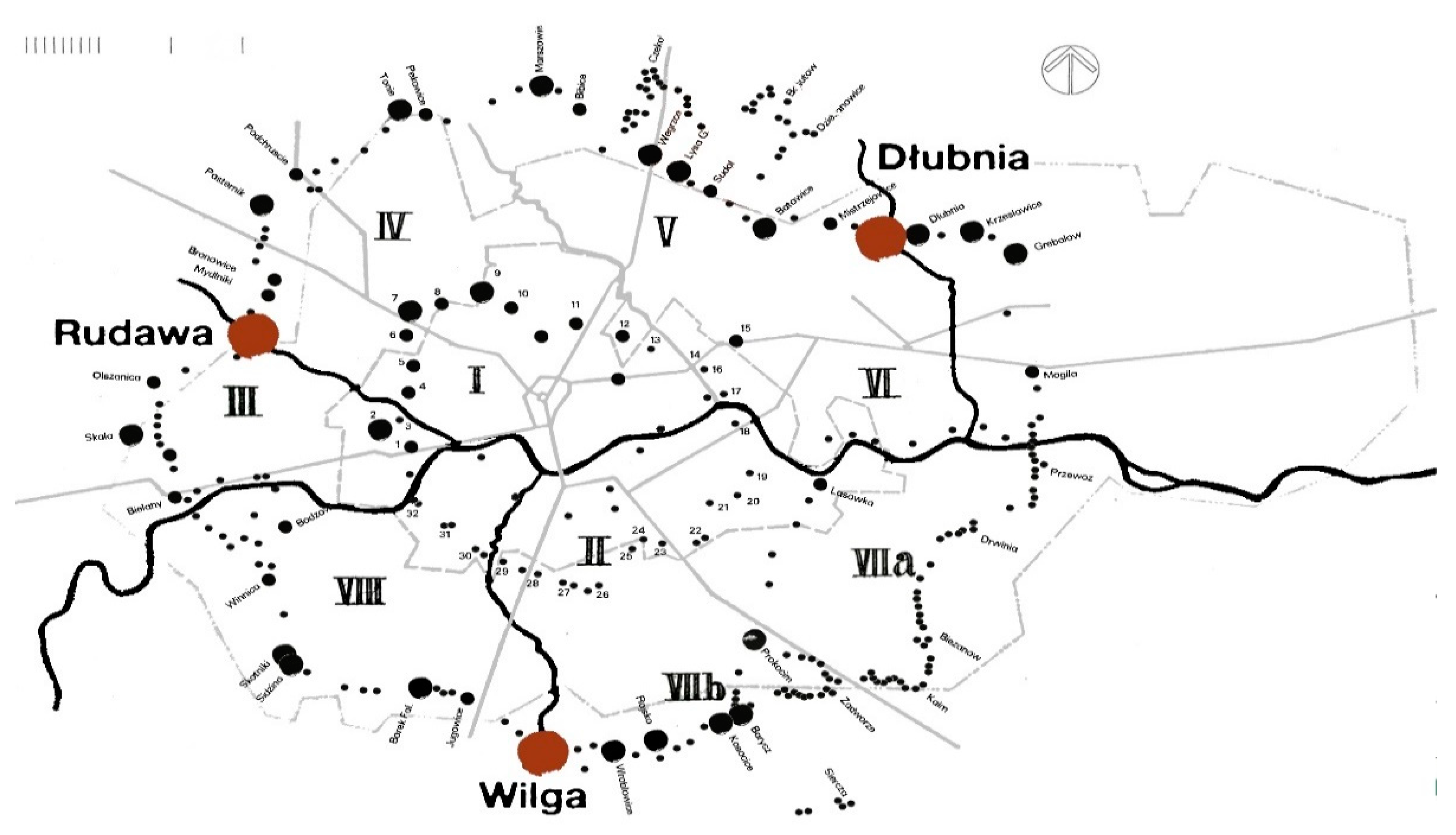
3.1.1. General Overview of the Three Artificial Dams

Nineteenth-century defensive doctrines assumed organizing most fortresses as ring-type structures, with an external ring of forwarding forts located in the foreground and an internal ring of continuous fortifications in direct proximity to the city they defended. Considerable tracts of land were used for defensive purposes and occupied by defensive structures (divided into covers, emplacements and obstacles) [22]. Construction bans were enacted around cities to leave a free field of fire and facilitate observation. Furthermore, military doctrine assumed supplementing the permanent fortification strip (forts and batteries) with field fortifications, necessary during a state of immediate threat and mobilization [17,22] (Figure 2).
Adaptive means and actions mainly involved “clearing the foreground” which entailed clearing forests, demolishing buildings, land leveling, etc. A constant readiness to quickly destroy bridge crossings was maintained. The potential for using water bodies and waterways for local impoundment was noted, as it would flood specific areas and make them impassable. Sapper instructions [16] highlighted the potential use of wide riverbeds and other terrain fortifications as obstacles. A watercourse could be turned into an obstacle by building hydraulic structures that formed artificial wetlands, blockages (weirs), or flooding. Depending on local conditions, they were either makeshift or comprehensive structures.
In the Krakow Fortress, the first and second defensive circuits were formed by the cities of Krakow and Podgórze, respectively, separated by the Vistula River. The borders of the remaining defensive circuits included water divisions. In the north, the third circuit stretched between the Vistula and Rudawa Rivers, the fourth from the Rudawa to the Białucha, the fifth from the Białucha to the Dłubnia, and the sixth from the Dłubnia to the Vistula. In the south, the fortification ring ran from east to west, towards the Vistula and was divided by the Wilga River into two defensive circuits [23]. With defensibility in mind, at the junction of the circuits mentioned earlier (Wilga, Rudawa, and Dłubnia), hydraulic structures were designed and built in 1914, enabling the creation of artificial inundation areas parallel to the frontline. The quality and effectiveness of these obstacles were defined using “storm resistance” ratings (originally called Sturmfreiheit in German). The mild or heavy flooding and wetlands created with them were to become a significant terrain obstacle [16].
Design operations preceded the process of creating such obstacles. The borders of future inundation areas were delineated, and the potential associated costs were assessed. The evaluation covered the profile of a river or channel, soil characteristics, bank incline parameters, water velocities, and information about pre-existing structures (bridges, levees, sluices, etc.). The sites for the newly designed crossings were also marked in the field, while accounting for the apparent optimization of means and resources [18].
Similar operations concerned the construction of the three dams on Dłubnia, Wilga, and Rudawa.
The Dłubnia River was impounded by improvising a blockage of the clearance under a bridge, with the concrete abutments simultaneously constituting the abutments of the weir (initially named the Dłubnia Stauanlage). These abutments featured vertical niches visible in the figure below, used to fasten a flat barrier (Figure 3). The dam was located along a road that connected Mogiła with Krakow. The nearest known and surviving fortification is Fort 49a Dłubnia, situated around 1 km to the north.
The Wilga’s waters were dammed using a particular complex of buildings and devices. Its course could be closed using the fortress’s valve weir and a second levee across the river valley (originally named Wilga Schleuße, Staudamm a.d. Wilga). They formed an extensive hydraulic structure dedicated strictly to military needs (Figure 4). Relatively near the weir, at around 0.5 km to the west, is the surviving Fort 52a Jugowice-Łapianka.
Water impoundment in the Rudawa river valley was performed between two waterways, namely between the Rudawa and its millrace, the Młynówka. It was located around 0.5 km to the south of Fort 41a Mydlniki. The impoundment was possible by building an earthen levee across the valley along with the channel connecting both waterways (originally named Rudawa Inundationsdamm). The inundation channel along with an embankment between the Rudawa and Rudawa’s millrace were built in an agricultural area. An archival photograph shows a fragment of the structure with the completed earthworks and the reinforcement of the levee bank using a layer of stone. The bed of the channel had a circular cross-section, typical for structures from the beginning of the twentieth century. The photograph also shows the reinforcement of the bank zone with a system of fascines, further strengthened by fences from wooden posts and wicker. From the side where attacks were to take place, a strip of obstacles from wire on barrier rods was built (Figure 5).

3.1.2. Overview of the Size and Depth of the Inundation Areas under Study

The material collected allowed for an in-depth analysis of the size of potential inundation areas. The literature (Biesiekierski, 1922) [18] points to the application of needle dams [24] with a maximum restriction level set at around 1.8 m. By analogy, this level was also assumed for the structures under analysis.
Archival maps drawn to a scale of 1:10,000 from 1899–1902 and 1914–1915 were used, as they contained a sufficient amount of information to complete the investigation. The authors determined the flood zones based on the analysis of the topographic layout of the area. The contour lines existing on the historical map were taken into account. The assumed maximum possible level of water accumulation (approx. 1.8 m) and the contour lines indicated the range of potential inundation zones.
In the case of archival maps from the end of the nineteenth and the beginning of the twentieth century, the investigation encountered obstacles in identifying permanent points (objects) that could be referenced to contemporary landmarks. In most cases, only the forts that have survived to the present day provided an anchor. The historical maps were overlaid on the existing maps of spatial development plans and the current topographic maps to identify the relation between the historical flood zones and the recent development of the analyzed areas.
Throughout the investigation concerning the Dłubnia weir, it was possible to determine the old inundation area as potentially being up to 62.2 ha (Figure 6). The inundation surrounding Fort Dłubnia from the west strengthened the designated division between the defensive districts.
As a result of the impoundment of the Wilga with a fortress levee, an inundation was produced that was confined by a railway embankment from the west and the natural terrain layout from the east (Figure 7). The estimated total area of the historical inundation is around 29.7 ha.
Fort Mydlniki and its foreground were protected using a levee that closed a historical inundation and its accompanying parallel channel. The inundation area closed off by the levee, estimated based on historical maps and calculations, was approximately 17.9 ha (Figure 8).

3.2. Subject of the Study in the Present Day

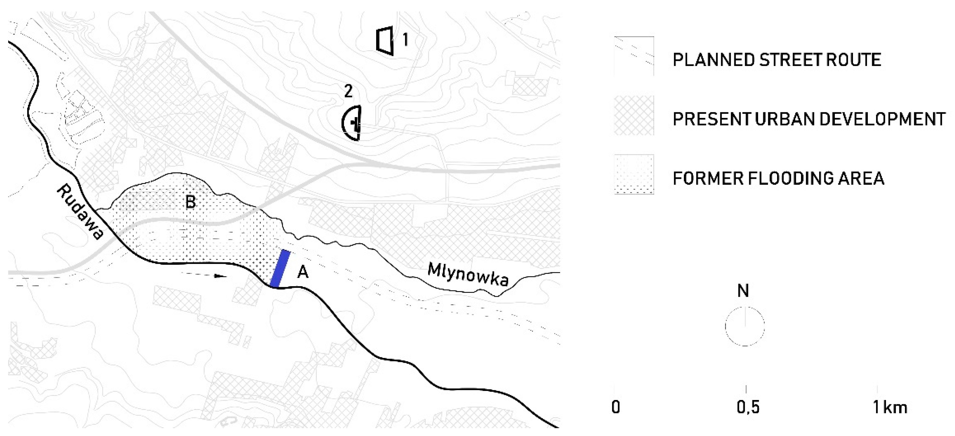
3.2.1. Site Inspection Results and Their Confrontation with Archival Materials

The investigation was located in the inundations in the contemporary structure of Krakow. A detailed site inspection was performed to search for any remains.
In the Dłubnia River area, due to the remodeling of the transport system, the construction of a new bridge crossing (Figure 9), and dynamic urbanization, no remains of historical hydraulic structures have survived.
In the Wilga riverbed, one can find the remains of its weir, in the form of a broken-up concrete slab and the fragment of the northern abutment of an earthen levee. The structural elements of the levee are visible, namely, the spaces between the stone walls filled with non-reinforced concrete and large-fraction lime aggregate. The area of the levee and weir complex is currently located in direct proximity to Krakow’s expressway bypass. A part of the complex abuts the roadway, while another is an overgrown area covered with wild plants (Figure 10).
In the Rudawa valley, urbanization processes and development expansion did not transform the area under study to a significant degree. Yet, agriculture and melioration work erased the course of the channel and the levee. Only a meadow is now present, slowly being overgrown with high greenery (Figure 11). The area is used to a minimal degree, mostly for farming and partially for strolling through non-landscaped greenery. The only site fully developed for recreation is a footpath that abuts the millrace bed. The technical infrastructure in the area is also not without significance: it consists of two underground Ø1200 water supply collector pipes and a high-voltage overhead power line.

3.2.2. Analysis of the Municipality’s Management Policies for the Areas under Study

The investigation of spatial development and environmental protection policy documents for Krakow first focused on the Spatial Development Conditions and Directions Study [25]. The analysis also covered other, more detailed documents on this subject, i.e., local spatial development plans drafted based on said Study [26,27,28,29] and relevant sectoral documents concerning development management.
In terms of the desired spatial structure [25] (Map K1: Spatial structure—development directions and precepts) the areas under study were assigned in both the study and applicable local plans for non-landscaped greenery conservation and design. The presence of various forms of surface waters and landscaped greenery, including parks, green squares, river parks and buffer greenery was also permitted [25] (Volume III—Guidelines for Local Plans, p. 10). Furthermore, in the Rudawa River area, a land reserve (crossing a green area) was created for the construction of a road that would connect Krakow’s downtown area with the Balice airport.
The study identifies a range of climate determinants, including potential threats such as “floods and inundations, draughts, cold and heat waves, mass soil movements” [25] (Volume I Development determinants, p. 74). In terms of proposed development rules and directions, all three locations were included in a landscape preservation and shaping zone, but not in the fortified landscape conservation zone [25] (Map K2: cultural environment—development and protection directions and precepts). Consequently, local development plans were also found not to highlight the historical significance of the locations in question. They were all included in the wildlife system structure as elements of river parks and cross-ventilation ecological corridors [25] (Map K3: natural environment—conservation and development conditions and precepts).
Another crucial document for this analysis is the Framework Conservation and Revitalization Program for the Historical-Landscape Complex of the Krakow Fortress [30].
The declared objectives of the program are to place fortification structures and their surrounding “fortified” landscape under legal protection, which includes the provision of local spatial development plans. The program assumes the need to revitalize these structures via their adaptive reuse as public or commercial facilities. The most valuable sites should be used as museums and exhibition spaces. The others had a range of research and academic, cultural, educational, recreational, and tourism-related uses assigned to them. The program identified a need for the general accessibility of restored fortifications by regulating legal and ownership-related matters. The structures of the fortress in possession of the Krakow municipality should be combined into a uniform historical-landscape complex, in which fortress greenery is to form a part of park areas. This document is a general collection of guidelines for the protection of fortification elements but does not mention water impoundment structures.
The document titled Development and Management Directions for Green Areas in Krakow for the years 2017–2030 is another source important to this study [31].
It asserts the necessity to form sequences of green areas that would act as ecological corridors. It indicates a need to integrate the scattered greenery structure into a continuous system, namely, the linking of existing and new public green areas via pedestrian and bicycle paths and green space sequences, to improve circulation potential and develop recreation. The document assumes a need to provide at least 10 m2 of landscaped recreational green areas per citizen. It also points to a need to support the conservation of cultural landscape zones by managing existing green space and establishing new green places.
The 2030 Krakow Climate Change Adaptation Plan [32] is an especially crucial document to this investigation. It concerns the consequences of ongoing climate change that are compounded by spatial development. It points to frequent torrential rain, inundation, flooding, and long periods with high temperatures, as well as intensive expansion of development and the growing number of vehicles. These phenomena result in a decrease in biologically active areas and water assets. The document specifies necessary preventative measures, including “informational and educational actions,” “organizational actions,” and “engineering actions” [20] (p. 6). The document provides a detailed list of necessary forms of activity and their associated capital expenditure. The highest priority was given to countering the consequences of floods, heatwaves, and worsening air quality via the development of broadly understood blue and green infrastructure.
The 2020–2030 Environment Protection Program Draft for the City of Krakow [33] is the last major document. Until September 2021, it had not been completed, yet its draft included crucial proposals for regulation intended to shape a socially acceptable city development strategy focused on environmental protection. In parallel, the program should facilitate socio-economic development. It includes a range of long-term goals, including the protection of Krakow’s wildlife and landscape assets, increasing the share of green areas, a rational water and waste management policy, improvements to air quality, a minimization of flood risk, and ecological education for residents. The draft comprehensively corresponds with the subject of the city’s spatial development and references other development strategy documents.

3.3. Analysis of the Collected Documentation in the Context of Modern Needs and Possibilities of Protecting the Heritage under Investigation

3.3.1. Analysis Conclusions

The analysis of archival materials presented in this study and their comparison with contemporary development strategy documents for Krakow indicated a need to take parallel action. The primary measures to be featured in these actions include:
  • The need for greater protection of the Krakow Fortress complex, including measures intended to conserve and restore the memory of buildings which are the most endangered and at risk of being forgotten.
This is the most obvious need, tied to raising public awareness about Krakow’s cultural identity. The materials present new elements of Krakow’s fortifications that were not previously covered by development plan provisions. The need for their greater protection nevertheless has a basis in the city’s general development strategies. It is also reflected in the Polish Act on Monument Protection and Preservation [34].
b.
The need to develop the city’s green spaces to strengthen recreational and educational functions.
In this context, establishing a waterfront park system is an excellent opportunity to create valuable leisure spaces that would be in a state of symbiosis with the river. The necessary directions of action highlighted in the strategy documents examined are confirmed in the literature. The cases of London, Toronto, or New York demonstrate how establishing waterfront park systems facilitates ecological education and even the promotion of the city [35].
c.
The need to find and design small-scale water retention sites in the spatial management system with the intent to make better use of dwindling water assets and limit the risk of local inundation.
The intensive urbanization observed over the past decades, in the absence of an effective planning system, increased Krakow’s vulnerability to floods. Creating water-absorbing areas is therefore a priority that is extensively noted in the city’s development strategies. Furthermore, these measures should account for the proper distribution of retention areas and thus improve their effectiveness [36], reduce the intensity of water surges [37,38], and enhance biodiversity in floodplains [39,40].
d.
The need to use and create a reserve of undeveloped land for creating cross-ventilation corridors, especially along waterways.
River valleys are areas of intensive air circulation. Ensuring they are corridors free from development is thus a priority for the correct cross ventilation of the city. This need is highlighted both in the analyzed strategy document and in many academic studies [41].
e.
The need for integrated action.
Listed last, the need for integrated action deserves a special mention. This integration, often articulated in the analyzed strategy documents, supports parallel action intended to diversify the funding of advanced and costly projects. This direction finds extensive application in numerous European and global means of formulating local development policies [42,43]. The literature highlights the significance of ensuring the spatial continuity of systems, which enhances recreational potential, improves the quality of the natural environment, and the effectiveness of valley retention [44,45]. It also points to cases of comprehensive attempts at solving hydrotechnical problems, matters of shaping landscape composition and creating recreational spaces for the city [46,47] in the form of “green chains” abutting rivers.

3.3.2. Proposal of Development Action for the Subject of the Study

The need for integration listed above resulted in an analysis of possible reconstructive action in the three spaces under study. The analysis covered possible forms of action, including the capacity to form new impoundments, their potential location under contemporary conditions, possible size, and significance.
Impoundment of the Dłubnia:
The confrontation of the original inundation area with the current land development showed that contemporary recreation of the historical state is not possible. A renewed attempt at impoundment would negatively affect the structure of a roadway embankment and would reduce the safety of Okulickiego Street, which runs to its south. However, such action is partially in alignment with the city’s policy, in the form of a waterfront park that would stretch along the bed of the Dłubnia, covering undeveloped space. This is an area with a length of around 500 m and a width that ranges between 80 and 230 m, occupying an area of 10.8 ha. This area could become the site of a so-called rain garden with a system of scattered, small reservoirs (ponds) which would infiltrate stormwater directly into the soil. An example of the possible layout of such ponds shall be presented in a reconstruction displayed in Figure 12. It was assumed that their combined area would not exceed half of the available site. By increasing small-scale water retention, this concept would provide a leisure space, develop biodiversity, and protect the surrounding space. This proposal should be supplemented by a properly developed information and education system (including historical photographs and a mockup of a reconstruction of the damming structure), which would propagate knowledge about the no-longer-existing fortress’s elements.
Impoundment of the Wilga:
The historical inundation area of the Wilga River determined in this study was also found to be impossible to recreate. The original impoundment significantly extends beyond present-day undeveloped areas. Photographic documentation allows for the precise determination of the architectural form and dimensions of the sluice itself. One possible action is to rebuild it and delineate a small inundation area that would be safe for the present-day surroundings, occupying around 3.8 ha. This proposal would be a reference to the historical impoundment, creating attractive conditions for recreation, including fishing. The inundation area could be supplemented by a waterfront park, located along the left bank of the Wilga and the highway, namely, at the site in which a larger inundation area would potentially threaten the road’s structural integrity. Such a park would occupy around 4.9 ha of land, and no more than half of the space would consist of water reservoirs laid out in a “chain” pattern (Figure 13). The recreated sluice, with displays showcasing its history, would be the main element of the complex, in compliance with the provisions of the Fortress Revitalization Program. Encompassing the nearby Borek, Jugowice and Wróblowice forts, all restored in 2021, the resultant complex would be highly valuable in terms of education and recreation.
The Rudawa River inundation area:
The former inundation area of the Rudawa is currently difficult to recreate. The primary hindrance here is underground municipal infrastructure that perpendicularly crosses the area, thereby limiting potential interventions. The land reserve stipulated in the area’s local spatial development plan, intended for road construction, is an obstacle here. Another difficulty is the inability to precisely identify the channel’s location. There are no clear traces of its presence in the area, and the applicable land development plan does not feature an obligation to reconstruct it. Despite this, the need for non-landscaped greenery which predominates in planning guidelines, can be used as a pretext for the location of a new hydrotechnical structure, and the channel identified in this study appears to be the most attractive element for reconstruction. Placed as it had been originally, perpendicular to the bed of the Rudawa, it would act as a retention reservoir that would allow water infiltration into the soil, with the possibility of draining its excess into the river [48]. The estimated area of the channel, delimited by the reserve of the planned road, is proposed to be around 0.3 ha. The channel would be primarily an earthen structure, linked with nearby transport and circulation routes, especially pedestrian ones. It would also be an excellent example for implementing similar solutions used for periodical retention in contemporary development. Analogously to other sites, it would require proper infrastructure and annotation, providing historical knowledge (Figure 14).
As a part of the investigation, an attempt was made to determine the effectiveness of the proposals presented by simulating their operation based on area estimates (Table 1).
The analysis covered the infiltration potential of the proposed solutions, as defined in three working models, while noting that the infiltration would be performed by the proposed reservoirs. The effectiveness of the total operation of the reservoirs in the waterfront parks of the Dłubnia and the Wilga was calculated, assuming maximum use. Analogous calculations were performed for the Rudawa channel. The total area of the reservoirs was set at a level of 40% of the area of the accompanying waterfront park. Each reservoir (pond) would receive surface runoff, retain it, and allow it to be absorbed into the soil. Any excess runoff would be redirected to the adjacent river [49,50]. Filtration speed was assumed to have the conditions of a unidimensional set flow through the soil, either partially or fully saturated with water, as found in Darcy [47]. It was also assumed that soil humidity increases along with depth, until the groundwater table is reached [51]. The initial groundwater level was assumed in concordance with the real-world conditions present in the areas under study [52]. The infiltration volumes for the proposed reservoir sizes, listed in m3∙s−1, are presented in Figure 15.
Furthermore, assuming an average depth for the infiltration reservoirs of only 1 m, their retention capacity would amount to 3000 m3 in the case of the Rudawa, 19,700 m3 in the case of the Dłubnia, and 43,000 m3 for the Wilga. These are volumes that can retain runoff from a fifteen-minute bout of torrential rain on a fully paved surface with an area of 30.8 ha. The areas were identified from which runoff towards the receiving waters is possible in terms of their topographic configuration. The retention capacity of the adopted solutions was estimated, The literature shows that the most significant influence on the value of the runoff coefficient is the type of catchment area coverage [53,54]. Therefore, to determine the average value of the runoff coefficient, the authors analyzed the land use of these areas (impervious roofs, roadways with asphalt surface, clinker surfaces, prefabricated concrete substrates, gravel paths, green spaces, etc.).
The analysis of the effectiveness of the proposed solutions demonstrates their significant potential. The final size selection of reservoirs requires detailed hydrological, hydraulic and topographic data. However, the findings presented prove the feasibility of simultaneous actions in which retention and infiltration significantly diminish the consequences of climate change, contributing to the conservation of cultural heritage. The authors primarily considered the risks associated with water management and extreme hydrometeorological events: heavy, violent rains, rising rivers, and periods of drought in the absence of adequate drainage and water accumulation.

4. Summary & Conclusions

The fortress structures under study, previously unknown in the literature and the city’s strategic documents, presented against the background of Krakow’s spatial development needs and dynamically changing climate conditions, were used to perform an in-depth analysis of their contemporary potential.
The investigation revealed potential for the protection of a dying heritage in the form of simultaneous efforts aligned with a wider spatial management and development conducive to recreation and even the promotion of the city. This protection, more directly than before, would also address climate threats and challenges, while creating the necessary blue–green infrastructure.
The investigation produced three proposals of design solutions that combine the following goals:
  • A presentation of knowledge about disappearing elements of the Krakow Fortress to a wide audience;
  • The revitalization of selected spaces, in full compliance with the applicable city development framework policy and higher-order legal acts;
  • The creation of new, attractive park spaces;
  • The implementation of solutions that would counteract the growing threats related specifically with sudden water surges or long-term water shortages;
  • The implementation of measures in a holistic, integrated system;
  • The implementation of activities towards diversifying funding sources (during construction and later operation) due to significance to cultural heritage, flood protection, establishing ecological corridors, developing tourism, recreation, and active social education.
The findings presented in this paper are a comprehensive proposal for taking action that would restore the memory of a widely unknown and disappearing cultural heritage and lay the groundwork for the implementation of the wider policy of sustainable development. Moreover, the concept of heritage, identification as part of the history of a place and its reception by inhabitants of Krakow, appears as a future research field.

Author Contributions

Conceptualization, methodology: F.S., W.K., validation, M.Ł., F.S., and W.K.; formal analysis: W.K.; investigation and resources: F.S. and M.Ł.; data curation, M.Ł. and F.S.; writing—original draft preparation, M.Ł., F.S., and W.K.; writing—review and editing, W.K.; visualization, F.S.; supervision, W.K.; project administration, W.K.; funding acquisition, W.K. All authors have read and agreed to the published version of the manuscript.

Funding

This publication received financial support from the Polish Ministry of Science and Higher Education under subsidy for science for the FA CUT in 2021.

Institutional Review Board Statement

Not applicable.

Informed Consent Statement

Not applicable.

Data Availability Statement

The input data in this research can be found within the article or accessed freely from online sources.

Conflicts of Interest

The authors declare no conflict of interest. The funders had no role in the design of the study; in the collection, analyses, or interpretation of data; in the writing of the manuscript, or in the decision to publish the results.

References

  1. Bogdanowski, J. Architektura Obronna w Krajobrazie Polski: Od Biskupina do Westerplatte; PWN: Warszawa, Poland; Kraków, Poland, 1996; ISBN 83-01-12223-4. (In Polish) [Google Scholar]
  2. Brzoskwinia, W.; Janczykowski, J. Zabytki Fortyfikacji Twierdzy Kraków: Ochrona i Konserwacja w Latach 1991–1998; seria II, t. 1; Atlas Twierdzy Kraków; Agencja Wydawnicza “ZEBRA”: Kraków, Poland, 1998; ISBN 83-87219-18-5. (In Polish) [Google Scholar]
  3. Suchoń, F. “The iron ring”. The fortification system as the constituting factor in the hybrid structure of the city-fortress. In Hybrid Urban Structures; PK: Kraków, Poland, 2016. [Google Scholar]
  4. Myczkowski, Z.; Wielgus, K.; Środulska-Wielgus, J.; Rymsza-Mazur, W.; Chajdys, K. Rejestracja Krajobrazów Warownych Jako Podstawa Rewitalizacji Dawnych Twierdz; Zarząd Główny Stowarzyszenia Konserwatorów Zabytków: Kraków, Poland, 2008. (In Polish) [Google Scholar]
  5. Linnerooth-Bayer, J.; Dubel, A.; Sendzimir, J.; Hochrainer-Stigler, S. Challenges for mainstreaming climate change into EU flood and drought policy: Water retention measures in the Warta River Basin, Poland. Reg. Env. Chang. 2015, 15, 1011–1023. [Google Scholar] [CrossRef]
  6. Cacciotti, R.; Kaiser, A.; Sardella, A.; De Nuntiis, P.; Drdacky, M.; Hanus, C.; Bonazza, A. Climate change-induced disasters and cultural heritage: Optimizing management strategies in Central Europe. Clim. Risk Manag. 2021, 32, 100301. [Google Scholar] [CrossRef]
  7. Vecco, M. A definition of cultural heritage: From the tangible to the intangible. J. Cult. Herit. 2010, 11, 321–324. [Google Scholar] [CrossRef]
  8. Fredheim, L.H.; Khalaf, M. The significance of values: Heritage value typologies re-examined. Int. J. Herit. Stud. 2016, 22, 466–481. [Google Scholar] [CrossRef]
  9. Spennemann, D.H.R. Beyond “Preserving the Past for the Future”: Contemporary Relevance and Historic Preservation. CRM J. Herit. Steward. 2011, 8, 7–22. [Google Scholar]
  10. Środulska-Wielgus, J. Rola Turystyki Kulturowej w Obronie i Udostępnieniu Krajobrazu Warownego; PK: Kraków, Poland, 2016. (In Polish) [Google Scholar]
  11. Środulska-Wielgus, J. Zieleń Twierdzy Kraków; seria II, t. 4; Atlas Twierdzy Kraków; Urząd Miasta Krakowa. Wydział Kultury i Dziedzictwa Narodowego. Oddział Ochrony Zabytków: Kraków, Poland, 2005. (In Polish) [Google Scholar]
  12. Myczkowski, Z.; Środulska-Wielgus, J.; Staniewska, A.; Wielgus, K.; Rymsza-Mazur, W. O przyszłość Twierdzy Kraków: Opracowanie Studialne Dla Programu Planu Ochrony Zespołu Historyczno-Krajobrazowego Twierdzy Kraków; CZUWAJMY: Kraków, Poland, 2010. (In Polish) [Google Scholar]
  13. Suchoń, F. 20th century fortress gates in Kraków as spatial marks of the city limits. In Tradition and Heritage in the Contemporary Image of the City: Monograph. Vol. 3, Practice and Process; Wydawnictwo PK: Kraków, Poland, 2014. [Google Scholar]
  14. Festungs-Umgebungs-Plan von Krakau, Special-Übersichts-Plan. K.u.k. Militär-Comité 1899. Hadtörténeti Intézet és Múzeum Budapest. Available online: https://maps.hungaricana.hu/en/HTITerkeptar/35477/view (accessed on 6 July 2021).
  15. Erd-, Bekleidungs- und Zimmermannsarbeiten: Befestigung. In Feld-Taschenbuch fur Officiere des Geniestabes und der Pionnier-Truppe; L.W. Seidel & Sohn: Wien, Austria, 1902. (In German)
  16. Theil, A: Feld- und beständige Befestigung. In Technischer Unterricht für die k. u. k. Pionnier-Truppe; k.k. Hof- und Staatsdruckerei: Wien, Austria, 1898. (In German)
  17. Brunner, M., Jr. Die beständige Befestigung. Für die k. u k. Militärbildungsanstalten und zum Selbstunterrichte für Offiziere aller Waffen; L.W. Seidel & Sohn: Wien, Austria, 1909. (In German) [Google Scholar]
  18. Biesiekierski, K. Fortyfikacja Polowa; Główna Księgarnia Wojskowa: Warszawa, Poland, 1922. (In Polish) [Google Scholar]
  19. Spennemann, D.H. Using KOCOA Military Terrain Analysis for the Assessment of Twentieth Century Battlefield Landscapes. Heritage 2020, 3, 753–781. [Google Scholar] [CrossRef]
  20. Czamara, W.; Olearczyk, D.; Stodolak, J.; Pardela, Ł. Możliwości wykorzystania historycznych danych topograficznych, hydrologicznychi hydraulicznych w procesie modelowania przepływu na przykładzie rzeki Ślęzy i Widawy. (Possibility of Historicaal Topographical, Hydrological and Hydraulic Data Use in Flow Modelling on Example of Ślęza and Widawa Rivers). Zesz. Naukowe. Inżynieria Sr. Uniw./Zielonogórski 2014, 154, 13–21. (In Polish) [Google Scholar]
  21. Stodolak, R.; Olearczyk, D.; Pardela, Ł.; Piecuch, T.; Tymiński, T. Budowle hydrotechniczne na potrzeby obronne Twierdzy Wrocław przełomu XIX i XX w. In Wybrane Zagadnienia Dokumentowania i Ochrony Zabytków Hydrotechniki; Kałuża, T., Wosiewicz, B., Eds.; Bogucki Wydawnictwo Naukowe: Poznań, Poland, 2017; pp. 65–77. (In Polish) [Google Scholar]
  22. Wilson, E.E.B.H. Some Recent Tendencies in Field Engineering. Prof. Mem. Corps Eng. United States Army Eng. Dep. Large 1912, 4, 638–668. [Google Scholar]
  23. Bogdanowski, J. Warownie i Zieleń Twierdzy Kraków; Wydawnictwo Literackie: Kraków, Poland, 1979. (In Polish) [Google Scholar]
  24. Kolouszek, S.; Pardela, Ł. Twierdza Wrocław jako unikalny zabytek, Achitectura Militaris, (Fortress Wroclaw—unique heritage of Architectura Militaris). Zesz. Nauk. WSOWL 2013, 2, 68–82. (In Polish) [Google Scholar]
  25. Kraków City Office. Uchwała Nr CXII/1700/14 Rady Miasta Krakówa z Dnia 9 Lipca 2014 r. w Sprawie Uchwalenia Zmiany Studium Uwarunkowań i Kierunków Zagospodarowania Przestrzennego Miasta Krakowa—Dokument Ujednolicony 2014. 2014. Available online: https://www.bip.krakow.pl/?id=48 (accessed on 2 August 2021).
  26. Kraków City Office. Uchwała Nr LXXII/1048/13 Rady Miasta Krakowa z Dnia 24 Kwietnia 2013 r. w Sprawie Uchwalenia Miejscowego Planu Zagospodarowania Przestrzennego Obszaru “Bieńczyce—Park Rzeczny Dłubni”. 2013. Available online: https://www.bip.krakow.pl/?dok_id=56021 (accessed on 6 July 2021).
  27. Kraków City Office. Uchwała Nr LVIII/776/12 Rady Miasta Krakowa z Dnia 10 Października 2012 r. w Sprawie Uchwalenia Miejscowego Planu Zagospodarowania Przestrzennego Obszaru “Młynówka Królewska—Zygmunta Starego”. 2012. Available online: https://www.bip.krakow.pl/?dok_id=53047 (accessed on 6 July 2021).
  28. Kraków City Office. Uchwała Nr CVII/2738/18 Rady Miasta Krakowa z Dnia 4 Lipca 2018 r. w Sprawie Uchwalenia Miejscowego Planu Zagospodarowania Przestrzennego Obszaru “Dolina Rudawy”. 2018. Available online: https://www.bip.krakow.pl/?dok_id=100574 (accessed on 6 July 2021).
  29. Kraków City Office. Uchwała Nr XII/130/11 Rady Miasta Krakowa z Dnia 13 Kwietnia 2011 r. w Sprawie Uchwalenia Miejscowego Planu Zagospodarowania Przestrzennego Obszaru “Swoszowice Uzdrowisko” z późn. Zmianami. 2011. Available online: https://www.bip.krakow.pl/?dok_id=45260 (accessed on 6 July 2021).
  30. Kraków City Office. Uchwała Nr CXIX/1294/06 Rady Miasta Krakowa z Dnia 25 Października 2006 r. w Sprawie Przyjęcia Dokumentu: ‘‘Ramowy Program Ochrony i Rewitalizacji Zespołu Historyczno—Krajobrazowego Twierdzy Kraków. 2006. Available online: https://www.bip.krakow.pl/_inc/rada/uchwaly/show_pdf.php?id=31042 (accessed on 7 July 2021).
  31. Kraków City Office. Kierunki Rozwoju i Zarządzania Terenami Zielonymi w Krakowie na lata 2019-2030”, Dokument Przyjęty Zarządzeniem Prezydenta Miasta Krakowa nr 2282/2019 z Dnia 09 Września 2019 r. 2019. Available online: https://www.bip.krakow.pl/?dok_id=115410 (accessed on 6 July 2021).
  32. Kraków City Office. Plan Adaptacji Krakowa do Zmian Klimatu do Roku 2030, Dokument Powstały w Ramach Projektu Ministerstwa Środowiska. Opracowanie Planów Adaptacji do Zmian Klimatu Miast Powyżej 100 tys. Mieszkańców. 2019. Available online: https://ngo.krakow.pl/zalacznik/319113 (accessed on 6 July 2021).
  33. Kraków City Office. Projekt Programu Ochrony Środowiska dla Miasta Krakowa na lata 2020–2030. 2021. Available online: https://www.bip.krakow.pl/?dok_id=139074 (accessed on 6 July 2021).
  34. Art. 6. Ustawy z Dnia 23 Lipca 2003 r. o Ochronie Zabytków i Opiece nad Zabytkam. Dz. U. 2003 Nr 162 poz. 1568 ze Zmianami. 2003. Available online: https://isap.sejm.gov.pl/isap.nsf/DocDetails.xsp?id=WDU20031621568 (accessed on 6 July 2021).
  35. Gordon, D.L.A. Planning, Design and Managing Change in Urban Waterfront Redevelopment. Town Plan. Rev. 1996, 67, 261–290. [Google Scholar] [CrossRef]
  36. Dunglas, J.; Chastan, B.; Lang, M.; Poulard, C.; Royet, P. Le Ralentissement Dynamique Pour la Prevention des Inondations. Guide des Aménagements Associant L’épandage des Crues Dans le Lit Majeur et Leur Écrętement Dans de Petits Ouvrages; Irstea: Rennes, France, 2004. [Google Scholar]
  37. Bai, T.; Mayer, A.L.; Shuster, W.D.; Tian, G. The Hydrologic Role of Urban Green Space in Mitigating Flooding (Luohe, China). Sustainability 2018, 10, 3584. [Google Scholar] [CrossRef] [PubMed] [Green Version]
  38. Xu, D.; Ouyang, Z.; Wu, T.; Han, B. Dynamic Trends of Urban Flooding Mitigation Services in Shenzhen, China. Sustainability 2020, 12, 4799. [Google Scholar] [CrossRef]
  39. Amoros, C.; Bornette, G. Connectivity and biocomplexity in waterbodies of riverine floodplains. Freshw. Biol. 2002, 47, 761–776. [Google Scholar] [CrossRef]
  40. Naiman, R.J.; Décamps, H.; Pollock, M. The role of riparian corridors in maintaining regional biodiversity. Ecol. Appl. 1993, 3, 209–212. [Google Scholar] [CrossRef] [PubMed]
  41. Szmelter, A.; Zdunek-Wielgoaska, J. Pre-war Inspirations in Shaping Green Spaces in Post-war Warsaw. IOP Conf. Ser. Mater. Sci. Eng. 2020, 960, 042003. [Google Scholar] [CrossRef]
  42. Buurman, J.; Babovic, V. Adaptation Pathways and Real Options Analysis: An approach to deep uncertainty in climate change adaptation policies. Policy Soc. 2016, 35, 137–150. [Google Scholar] [CrossRef] [Green Version]
  43. Hammond, M.; Chen, A.S.; Batica, J.; Butler, D.; Djordjević, S.; Gourbesville, P.; Manojlović, N.; Mark, O.; Veerbeek, W. A new flood risk assessment framework for evaluating the effectiveness of policies to improve urban flood resilience. Urban Water J. 2018, 15, 427–436. [Google Scholar] [CrossRef]
  44. Januchta-Szostak, A. Multifunctional Riverside Buffer Parks—The Research on Nature-Urban Revitalisation of River Valleys. J. Sustain. Arcitecture Civ. Eng. 2013, 4, 42–50. [Google Scholar]
  45. Januchta-Szostak, A. The Water Impact on the Quality of Urban Space. Research on urban river spaces revitalisation processes in the northern Poland. In Landscape Legacy. Landscape Architecture and Planning Between Art and Science; Carsjens, G.J., Ed.; Wageningen University: Wageningen, The Netherlands, 2010. [Google Scholar]
  46. Zachariasz, A. Woda Jako Element Kompozycji Parków Publicznych, (Water as a Composition Element of Public Parks), Woda w Przestrzeni Przyrodniczej i Kulturowej; Komisja Krajobrazu Kulturowego PTG, Oddział Katowicki PTG: Sosnowiec, Poland, 2003; pp. 325–336. (In Polish) [Google Scholar]
  47. Zachariasz, A. Architekt Krajobrazu Frederick Law Olmsted Senior Oraz Amerykańskie Parki i Systemy Parków Miejskich, (Landscape Architect Frederick Law Olmsted Senior and American Parks and City Pak Systems); Teka Komisji Urbanistyki i Architektury, T.35; Polska Akademia Nauk Oddział Kraków: Kraków, Poland, 2004; pp. 153–166. (In Polish) [Google Scholar]
  48. Zelenakova, M.; Diaconu, D.C.; Haarstad, K. Urban water retention measures. Struct. Phys. Asp. Constr. Eng. Procedia Eng. 2017, 190, 419–426. [Google Scholar]
  49. Edel, R. Odwodnienie Dróg; Wydawnictwa Komunikacji i Łączności WKŁ: Warszawa, Poland, 2000. (In Polish) [Google Scholar]
  50. Geiger, W.; Dreseitl, H. Nowe Sposoby Odprowadzania wód Deszczowych. Poradnik Retencjonowania i Infiltracji wód Deszczowych do Gruntu na Terenie Zabudowanym; Oficyna Wydawnicza Projprzem-EKO: Bydgoszcz, Poland, 1999. (In Polish) [Google Scholar]
  51. Zevenbergen, C.; Cashman, A.; Evelpidou, N.; Pasche, E.; Garvin, S.; Ashley, R. Urban Flood Management; CRC Press: London, UK, 2011. [Google Scholar]
  52. Pociask-Karteczka, J. Wody podziemne. In Opracowanie Ekofizjograficzne Miasta Krakowa do Zmiany Studium Uwarunkowań i Kierunków Zagospodarowania Przestrzennego; Degórska, B., Ed.; Urząd Miasta Krakowa: Kraków, Poland, 2010. (In Polish) [Google Scholar]
  53. Suligowski, Z. Infrastruktura Kanalizacyjna w Gospodarce Komunalnej; Wydawnictwo, P.G., Ed.; Politechnika Gdańska: Gdańsk, Poland, 2006. (In Polish) [Google Scholar]
  54. Lallam, F.; Megnounif, A.; Ghenim, A.N. Estimating the runoff coefficient using the analytic hierarchy process. J. Water Land Dev. 2018, 38, 67–74. [Google Scholar] [CrossRef] [Green Version]
Figure 1. Diagrammatic plan of the Krakow Fortress with the locations of previously unknown impoundment structures marked in dark brown, accompanied by the boundaries of defensive areas I through VIII.
Land 10 01273 g001
Figure 2. Fragment of the original plans from 1915 concerning field fortifications, an obstacle course, and a water damming on Dłubnia. From the authors’ private collection.
Land 10 01273 g002
Figure 3. View of a bridge on the Dłubnia, archival photo from 1933. Note the massive concrete abutments that were also used by the weir. From the collection of the Polish National Digital Archives, signature no. 3/1/0/8/3240.
Land 10 01273 g003
Figure 4. View of the damming wall of the Wilga-Schleuße fortress weir, seen from the side of the inundation area. Archival photograph from 1915. From the author’s collection.
Land 10 01273 g004
Figure 5. View of the levee and inundation channel from the side of the Rudawa millrace. Archival photograph from 1915, from the author’s collection.
Land 10 01273 g005
Figure 6. Reconstruction of the Dłubnia inundation area for the state from 1915. The watercourse was blocked by an improvised blockade under a bridge clearance. The water flowing downstream (due south) spilled successively into the river valley. Markings: A. location of the levee, B. inundation area, C. wire obstacle strip; 1. Fort Dłubnia, 2. Earthwork 1/Dłubnia, 3. Fort Mistrzejowice, 4. Fort Batowice, and 5. Fort Sudół. The expected avenues of attack are marked with arrows.
Land 10 01273 g006
Figure 7. Reconstruction of the Wilga inundation area for the state from 1915. The watercourse was blocked by the fortress weir. The water flowing downstream (due north) spilled successively into the river valley. Markings: A. location of the levee, B. inundation area, C. wire obstacle strip; 1. Fort Borek, 2. Fort Jugowice (a.k.a. Łapianka), and 3. Fort Wróblowice. The expected avenues of attack are marked with arrows.
Land 10 01273 g007
Figure 8. Reconstruction of the Rudawa inundation area for the state from 1915. A channel was made connecting the river bed with the millstream (Młynówka). The water current filled the flat area between the two flows. Markings: A. location of the levee, B. inundation area, C. wire obstacle strip; 1. Fort Bronowice Małe, 2. Fort Mydlniki, and 3. Earthwork 1/Olszanica with batteries 1/Olszanica and 2/Olszanica. The expected avenues of attack are marked with arrows.
Land 10 01273 g008
Figure 9. Current state of preservation of the Dłubnia inundation area, 2021.
Land 10 01273 g009
Figure 10. Current state of preservation of the remains of the fortress weir on the Wilga River, 2021.
Land 10 01273 g010
Figure 11. Current state of preservation of the Rudawa impoundment area, 2021.
Land 10 01273 g011
Figure 12. Proposal of a new inundation zone (as a part of a waterfront park) of the Dłubnia River. Markings: A. original location of the impoundment weir, B. border of the historical inundation area; 1. Fort Dłubnia, and 2. Fort Mistrzejowice.
Land 10 01273 g012
Figure 13. Proposal for a new inundation zone for the Wilga River. Markings: A. location of the weir and levee, B. border of the historical inundation area; 1. Fort Jugowice (a.k.a. Łapianka, currently a Scout Movement Museum).
Land 10 01273 g013
Figure 14. Proposal of an infiltration channel for the Rudawa River. Markings: A. location of the historical levee and irrigation channel—proposed site for the channel and infiltration reservoir, B. border of the historical inundation area; 1. Fort Bronowice Małe, and 2. Fort Mydlniki.
Land 10 01273 g014
Figure 15. Infiltration volume changes for the proposed infiltration reservoirs located in the Dłubnia and the Wilga waterfront parks and the Rudawa channel.
Land 10 01273 g015
Table 1. Estimation of the area size of historical and proposed inundation areas.
RiverHistorical Inundation Area (ha)Presently Available Space for Inundation Area Reconstruction (ha)Proposed Form of UseProposed Form of Use Area [ha]/Infiltration Area (ha)
Wilga29.78.7Reservoir3.8/---
Waterfront park with infiltration reservoirs4.9/2.0
Dłubnia65.210.8Waterfront park with infiltration reservoirs10.8/4.3
Rudawa17.90.3Infiltration channel0.3/0.3
Publisher’s Note: MDPI stays neutral with regard to jurisdictional claims in published maps and institutional affiliations.

