European Land Use Spatial Data Sources and Their Role in Integrated Planning: Opportunities and Challenges for Poland
Abstract
1. Introduction
2. Theoretical Background of the Research
2.1. The Evolution of Land Use Planning in the World
2.2. Evolution of Land-Use and Spatial Planning in Europe
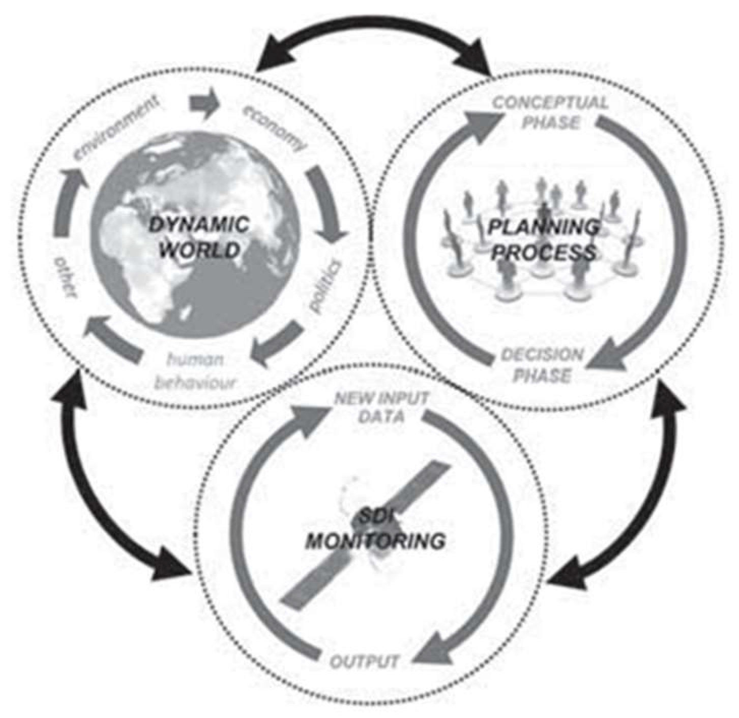
2.2.1. Spatial Data Infrastructure and Its Role in Contemporary Planning
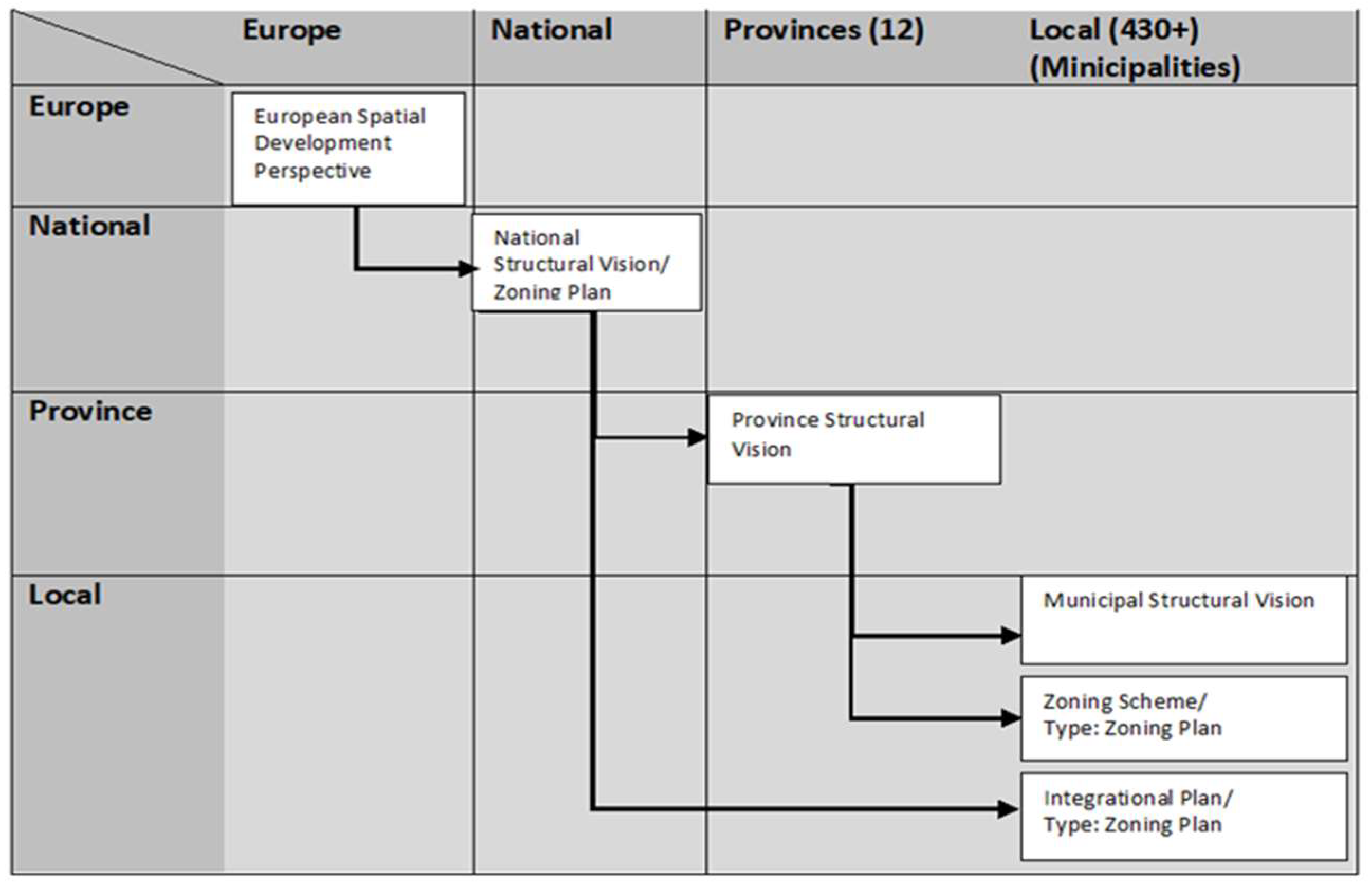
2.2.2. Classification of Spatial Planning System in EU
- Nationwide comprehensive collections of urban planning standards;
- Direct, obligatory planning guidelines of higher order plans to local plans;
- Control systems for the implementation of these safeguards.
- Planning the regional economy (‘economic and regional’);
- Comprehensive planning (‘comprehensive integrated’);
- Based on land use management (‘land’);
- Urban planning (‘defined as urbanism’).
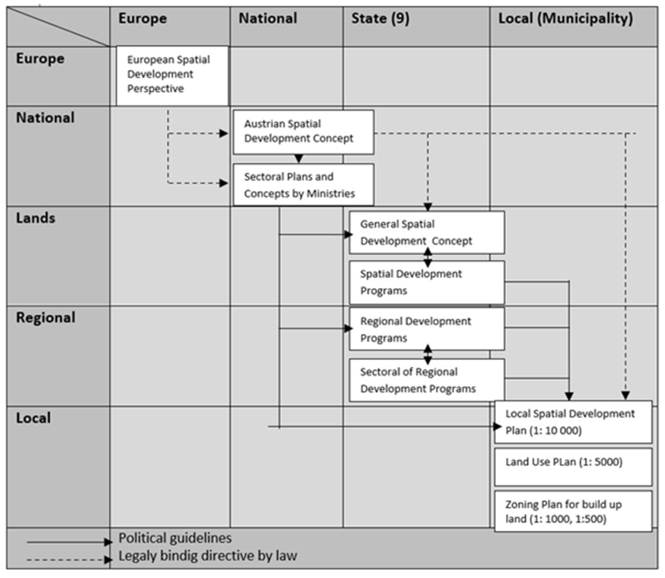
2.2.3. European Spatial Planning in Practice: Selected Countries
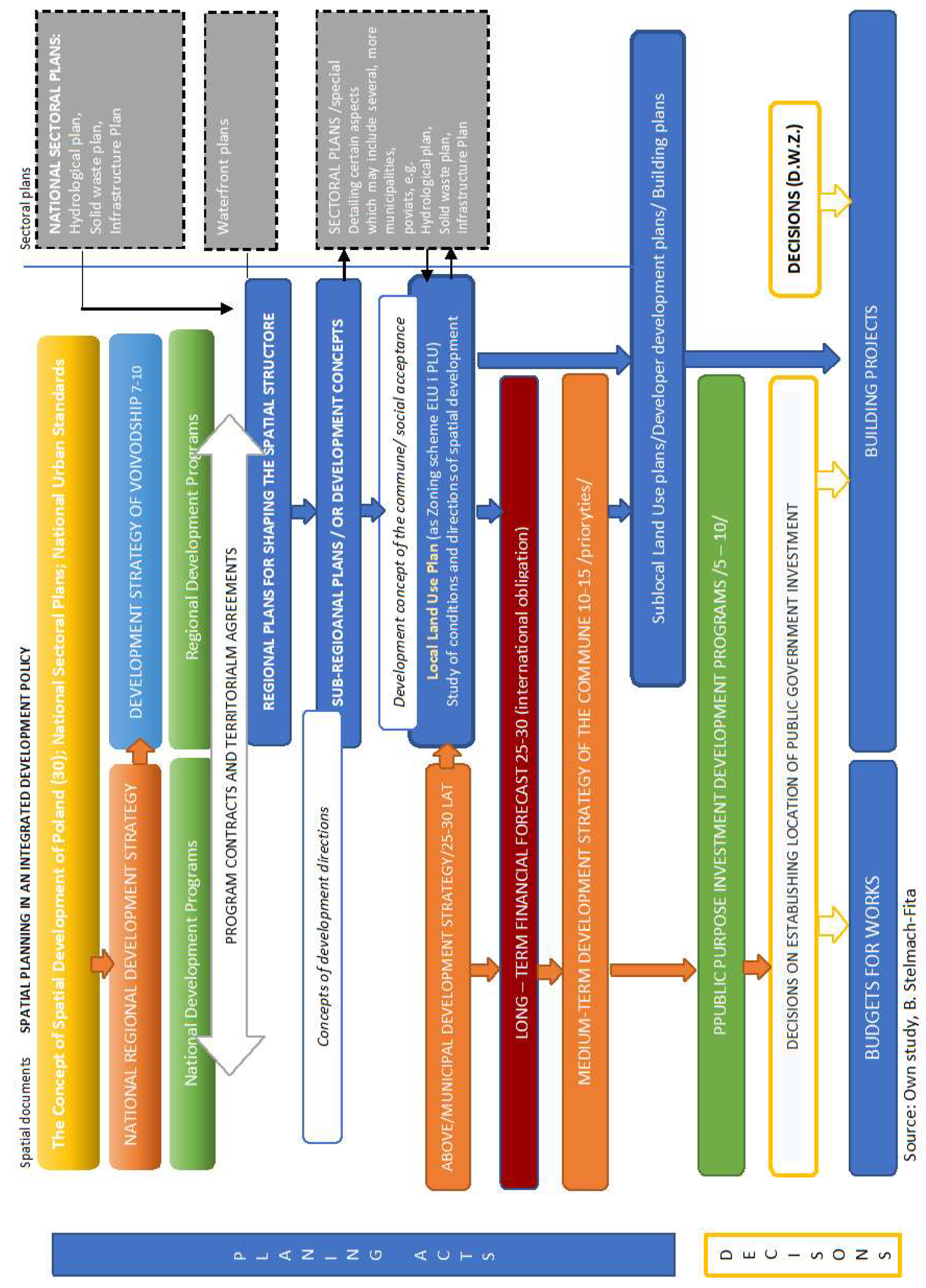
2.2.4. Spatial Planning Acts Versus Location Decisions in Poland
3. Material and Methods
4. Results
4.1. Author’s Analysis of Technical Guidelines Inspire for Land Use
4.2. The Empirical Part 2011–2013
4.2.1. The Survey Aimed at Key Specialists and Experts—2011
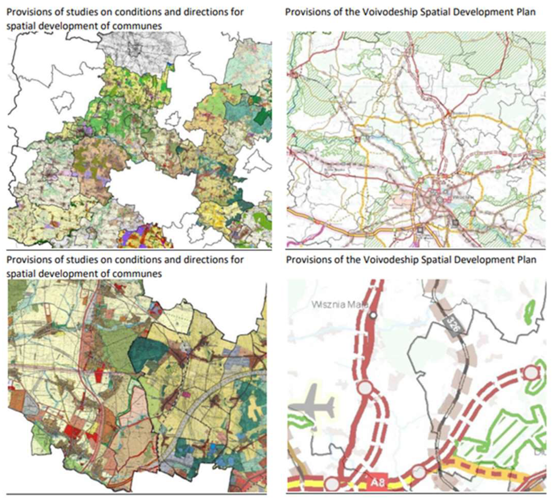
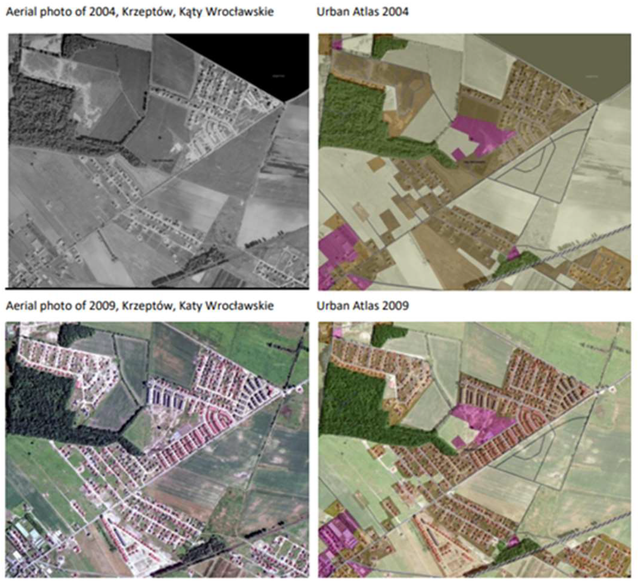
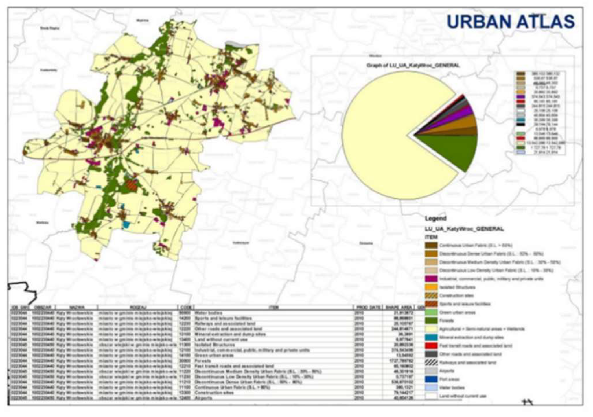
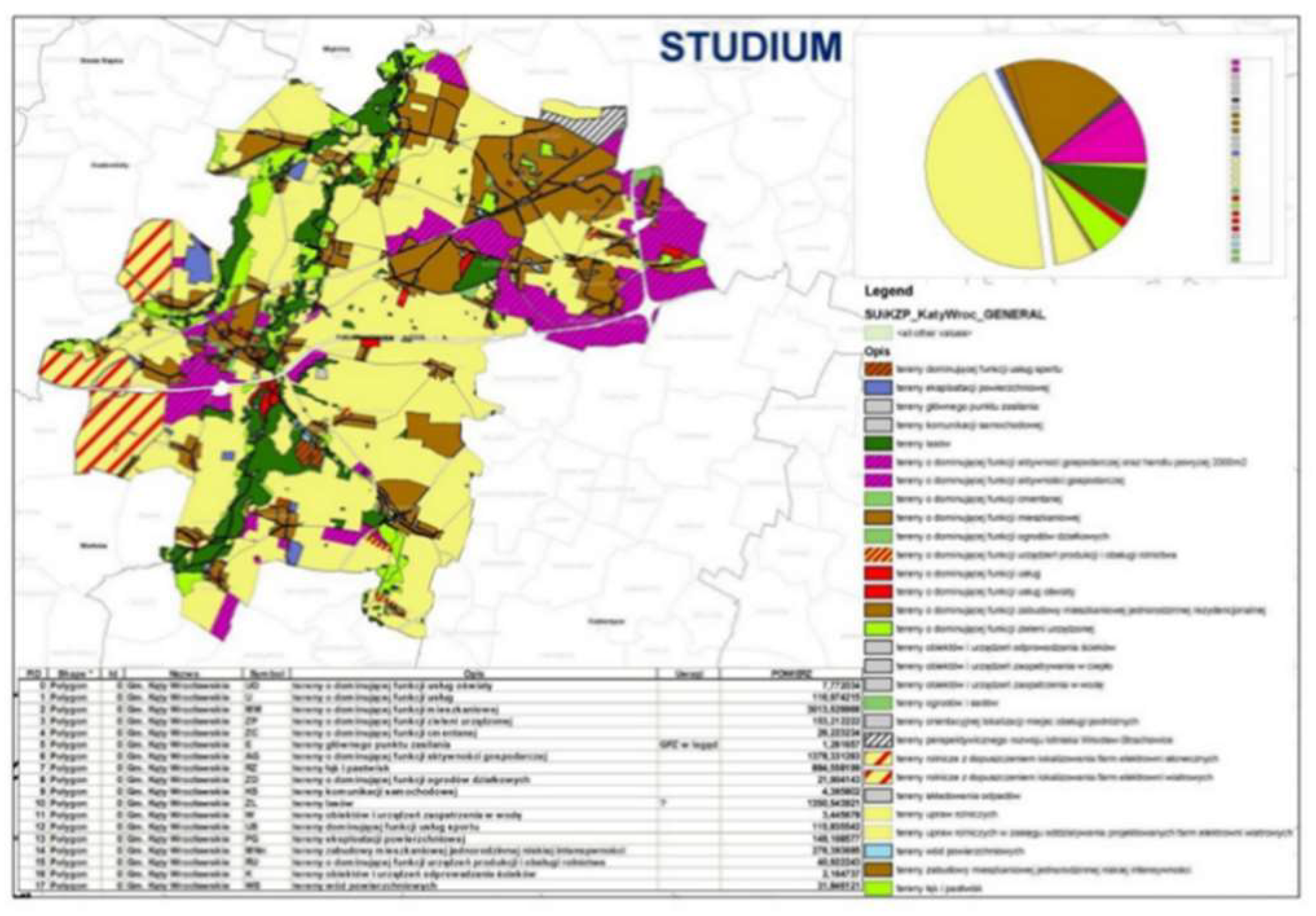
4.2.2. Case Study of Activities Undertaken in a Planning Unit at the Regional Level in the Lower Silesian Voivodeship
| The Directions of Spatial Development from the ‘Study’ (Suikzp) Harmonized in UA English | Urban Atlas |
|---|---|
| Areas with the dominant function of sports services | Sports and leisure |
| Areas of surface exploitation | Mineral extraction and dump sites |
| Main point of electro-magnetic power | Isolated structures |
| Car communication areas | Other areas and associated land |
| Forest areas | Forest |
| Areas with the dominant function of economic activity and trade >2000 m2 | Industrial, commercial, public, military, and private unis |
| Areas with a dominant economic function | Industrial, commercial, public, military, and private unis |
| Areas with a dominant cemetery function | Green urban areas |
| Areas with a dominant residential function | Discontinuous medium density urban fabric |
| Areas with the dominant function of allotment gardens | Green urban areas |
| Areas with a dominant function of agricultural production and service equipment | Agricultural, semi-natural, and wetland areas |
| Areas with a dominant service function | Industrial, commercial, public, military, and private unis |
| Areas with the dominant function of educational services | Industrial, commercial, public, military, and private unis |
| Areas with a dominant function of single-family residential housing | Continues urban fabric |
| Areas with a dominant function of arranged greenery | Green urban areas |
| Areas of facilities and devices for sewage disposal | Industrial, commercial, public, military, and private unis |
| Areas of facilities and equipment for supplying heat | Industrial, commercial, public, military, and private unis |
| Areas of water supply facilities and devices | Industrial, commercial, public, military, and private unis |
| Garden and orchard areas | Agricultural, semi-natural and wetland |
| Areas of indicative service of passenger service areas | Industrial, commercial, public, military, and private unis |
| Areas of prospective development of the Wroclaw–Starachowice airport | Industrial, commercial, public, military, and private unis |
| Agricultural land with the possibility of locating solar farms | Agricultural, semi-natural, and wetland |
| Agricultural crops within the impact range of the designed wind farms | Agricultural, semi-natural, and wetland |
| Surface water areas | Water |
| Low-intensity residential development areas | Discontinuous law density urban fabric |
| Areas of meadows and pastures | Agricultural, semi-natural, and wetland |
4.3. Empirical Part of Research—2017–2019
4.3.1. A Questionnaire Survey Addressed to 16 Marshal Offices in Poland—2017
A—Departments for Spatial Information Infrastructure
- Does the regional SDI node include the voivodeship development plan?
- 2.
- Does the regional SDP contain decision location maps in services: wms, wfs?
- 3.
- Does the regional SDP node contain other datasets?
- 4.
- Could the Marshal’s Office provide SDP for the needs of the Voivode’s Office for the collection of locations of decisions issued by the Voivode when establishing legal regulations?
B—Spatial Planning Office
- Are decision location maps needed in the Marshal’s registers, available in the WFS, WMS, and SDP network services to update the PZPW (PZPW—this is the acronym of the name of the Voivodeship Development Plan)?
- 2.
- Do you need to update the PZPW with decision location maps from the Voivode’s registers as available in the form of network services?
- 3.
- Do you use cooperation with ROT (ROT—this is an acronym of the Regional Territorial Observatory) to update/create a new PZPW for the purposes of spatial analyzes, e.g., in the field of collecting information?
- 4.
- Should decision location maps issued at the local and voivodship level be made available to investors, entrepreneurs, entities agreeing, giving opinions or other users?
4.3.2. Case Study of Activities in a Planning Unit at the Regional Level in the Pomeranian Voivodship
4.3.3. Analysis of the Legal Status, Model Self-Correction
- voivodeship spatial development plans, including spatial development plans for the functional urban area of a voivodeship center,
- framework studies of the conditions and directions of spatial development of the metropolitan association,
- studies,
- local plans,
- local reconstruction plans,
- local revitalization plans.
5. Discussion
Supplementary Materials
Funding
Institutional Review Board Statement
Informed Consent Statement
Data Availability Statement
Acknowledgments
Conflicts of Interest
Appendix A
References
- Annoni, A. INSPIRE and the Digital Agenda for Europe. Spatial Data Infrastructures Unit; European Commission. Polish Association for Spatial Information, Annals of Geomatics; Institute for Environment and Sustainability; Joint Research Centre: Warszawa, Poland, 2011; Volume IX, pp. 17–27. Available online: http://rg.ptip.org.pl/index.php/rg/artcle/view/RG2011-5-Annoni/1402 (accessed on 12 August 2021).
- Stelmach-Fita, B. European Sources of Spatial Data on Land Use: Need Constraints. In Studies of the Industrial Geography Commission of the Polish Geographical Society; Polish Geographical Society—Industrial Geography Commission, Pedagogical University of Krakow and Institute of Geography, Department of Entrepreneurship and Spatial Management: Krakow, Poland, 2017; Volume 31, pp. 185–203. [Google Scholar] [CrossRef]
- Toth, K.; Portele, C.; Lilert, A.; Lutz, M.; Nunes de Lima, N. Model Koncepcyjny Rozwijania Specyfikacji Interoperacyjności w Infrastrukturach Danych Przestrzennych. Raporty Referencyjne IRC.; Raport EUR 25280 EN.; Komisja Europejska, Urząd Publikacji Unii Europejskiej: Luxembourg, 2012. Available online: http://www.radaiip.gov.pl/__data/assets/pdf_file/0004/29614/IES_Spatial_Data_InfrastructuresPL.pdf (accessed on 21 July 2021).
- Chmielewski, J. Analiza zmian legislacyjnych dokonywanych od 1961 do 2003 roku, z punktu widzenia charakterystyki zmian ustrojowych i ich wpływ na usytuowanie (kompetencje, prawa i obowiązki) wszystkich podmiotów biorących aktywny udział w planowaniu i rzutujących na sprawność procesu planowania. In Planowanie Przestrzenne w Polsce po Wprowadzeniu Ustroju Samorządu. Diagnoza Stanu i Nowe Propozycje; IGPIM: Warszawa, Poland, 2008; pp. 7–89. [Google Scholar]
- Chmielewski, J. Teoria I praktyka planowania przestrzennego. Urbanistyka Europy, 1st ed.; Oficyna Wydawnicza Politechniki Warszawskiej: Warsaw, Poland, 2016; pp. 212–214. [Google Scholar]
- Tölle, A. Integrated forms of planning and managing local development and the planning toolkit. The contrast between the polish and German system. Studia Reg. i Lokalne 2014, 3. Available online: https://studreg.uw.edu.pl/pl/archiwum,zintegrowane-formy-planowania-i-zarzadzania-rozwojem-lokalnym-a-instrumentarium-planistyczne-system-polski-na-tle-systemu-niemieckiego (accessed on 29 August 2021). [CrossRef]
- Stelmach-Fita, B. Public access to the data on Land Use. Needs and limitations. In Współczesne Uwarunkowania Gospodarowania Przestrzenią-Szanse i Zagrożenia dla zróWnoważonego Rozwoju. Społeczny Wymiar Gospodarowania Przestrzenią. Seria “Monografie. Gospodarka Przestrzenna; Maciejewska, A., Ed.; Wydział Geodezji Politechniki Warszawskiej: Warszawa, Poland, 2014; T. VI; pp. 9–23. [Google Scholar]
- Stelmach-Fita, B. Rola geoinformacji we współdziałaniu jednostek samorządowych z przedsiębiorcami. In Przedsiębiorczość—Edukacja (12); Pedagogical University of Krakow: Krakow, Poland, 2016; pp. 85–97. [Google Scholar] [CrossRef]
- Izdebski, W.; Śleszyński, P.; Malinowski, Z.; Kursa, M. Analiza Morfologiczna Planów Miejscowych w Polsce, Commission of Technical Rural Infrastructure; Polish Academy of Sciences: Krakow, Poland, 2018. [CrossRef]
- Ustawa o Infrastrukturze Informacji Przestrzennej z 4 Marca 2010 Roku (t. j. Dz. U. 2021 poz. 214). Available online: http://isap.sejm.gov.pl/isap.nsf/download.xsp/WDU20210000214/T/D20210214L.pdf (accessed on 21 August 2021).
- Kaczmarek, I.; Iwaniak, A.; Łukowicz, J. New Spatial Planning Data Methods through the Implementation of the Inspire Directive. Real Estate Manag. Eval. 2014, 22, 12–14. [Google Scholar] [CrossRef][Green Version]
- Maciejewska, A.; Andrzejewska, M.; Augustynowicz, A.; Bielecka, E.; Brzeski, B.; Kozak, J.; Mączewski, K.; Sikora, E.; Śleszyński, P.; Widz, R.; et al. Geoinformacja Zmienia Świat; Maciejewska, A., Ed.; Główny Urząd Geodezji i Kartografii: Warszawa, Poland, 2018; pp. 155–163.
- Laurence, E.L., Jr.; Hernrich, C.J.; Hill, C.J. Studying Governance and Public Management: Challenges and Prospects. J. Public Adm. Res. Theory 2000, 10, 233–262. [Google Scholar] [CrossRef]
- Matternicht, G. Land Use Planning. 2017. Available online: https://knowledge.unccd.int/sites/default/files/2018-06/6.%20Land%2BUse%2BPlanning%2B__G_Metternicht.pdf (accessed on 23 August 2021).
- Australia, S.O.W. Review of Planning and Development and Development Act 2005.2013: Perth, WA, Australia, 39. Available online: https://www.legislation.wa.gov.au/legislation/prod/filestore.nsf/FileURL/mrdoc_29428.pdf/$FILE/Planning%20and%20Development%20Act%202005%20-%20%5B04-c0-02%5D.pdf?OpenElement (accessed on 23 August 2021).
- Schrank, M.; Neuschmis, J.; Petti, D.; Wasserburger, W. Interoperability, SDI and spatial planning. In Plan4all Project Interoperability for Spatial Planning; Salvemini, M., Vico, F., Lannucci, C., Eds.; Plan4all Consortium: Horní Bříza, Czech Republic, 2011; pp. 41–54. [Google Scholar]
- Vancutsem, D. Spatial planning and ICT. In Plan4all Project Interoperability for Spatial Planning; Salvemini, M., Vico, F., Iannucci, C., Eds.; Plan4all Consortium: Horní Bříza, Czech Republic, 2011; pp. 27–38. [Google Scholar]
- Stelmach-Fita, B. New Integrated Planning in the Context of Shaping and Development of Industrial and Service Areas in Metropolitan Regions. In Changes in Industry and Its Environment in Spatial Systems; Studies of the Industrial Geography Commission of the Polish Geographical Society; Polish Geographical Society—Industrial Geography Commission Pedagogical University of Krakow and Institute of Geography Departament of Entrepreneurship and Spatial Management: Krakow, Poland, 2019; Volume 33, pp. 260–282. [Google Scholar] [CrossRef]
- Cieślak, A. Narodowa strategia ZZOP: Zarys polskiego punktu widzenia. In Integrate Coastal Zone Management at the Szczecin Lagoon: Exchange of experiences in the region. Coastline Rep. 2005, 6, 11–18. Available online: http://www.ibwpan.gda.pl/storage/app/media/inet/02_cieslak.pdf (accessed on 21 July 2021).
- Dylewski, R.; Nowakowski, M.; Szopa, M.; Niewiadomski, Z.; Tomaszek, S. Poradnik Urbanisty: Standardy, Przykłady, Przepisy, 2nd ed.; Towarzystwo Urbanistów Polskich: Warszawa, Poland, 2004. [Google Scholar]
- Schrank, M.; Neuschmis, J.; Wasserburger, W. Planning systems in Europe and SDIs. In Plan4all Project Interoperability for Spatial Planning; Salvemini, M., Vico, F., Lannucci, C., Eds.; Plan4all Consortium: Horní Bříza, Czech Republic, 2011; pp. 65–76. [Google Scholar]
- Ledwoń, S. Planowanie inwestycji wielkiej skali w europejskich systemach planowania przestrzennego. In Planowanie i Realizacja Przedsięwzięć Urbanistycznych. Miasto.Metropolia.Region, 1st ed.; Politechnika Gdańska: Gdańsk, Poland, 2011; pp. 6–22. Available online: https://arch.pg.edu.pl/documents/174968/51761959/skrypt%204.pdf (accessed on 23 August 2021).
- Larsson, G. Systemy Planowania Przestrzennego w Europie Zachodniej, 1st ed.; Mazowiecka Okręgowa Izba Architektów RP: Warszawa, Poland, 2013; pp. 192–201. [Google Scholar]
- Concept Regulation of Minister of Housing, Spatial Planning and Environment of 2008. Holand. Available online: http://ec.europa.eu/enterprise/tris/pisa/cfcontent.cfm?vFile=120080195EN.PDF (accessed on 12 November 2012).
- Topczewska, T. Zintegrowane Planowanie Rozwoju i Rewitalizacji Miast w Wybranych Krajach ”Starej” UE i w Polsce. Człowiek i Środowisko; Instytut Gospodarki Przestrzennej i Mieszkalnictwa: Warszawa, Poland, 2010; Volume 1–2, pp. 8–16. [Google Scholar]
- Śleszyński, P.; Andrzejewska, M.; Cerić, D.; Deręgoeska, A.; Komornicki, T.; Rusztecka, M.; Solon, J.; Sudra, P.; Zielińska, B. Analiza stanu i uwarunkowań prac planistycznych w gminach w 2014 roku. In IGiPZ PAN, na Zlecenie Ministra Infrastruktury I Rozwoju; MiiR: Warszawa, Poland, 2016. [Google Scholar]
- Jaroszewicz, J.; Parzyński, J. Informacja Referencyjna dla Planów Zagospodarowania Przestrzennego w Systemach Geoinfomacyjnych Reference Information for Spatial Management Plans in Geo-Information Systems; Polskie Towarzystwo Informacji Przestrzennej, Roczniki Geomatyki: Warsaw, Poland, 2016; T. XIV; Volume 3, pp. 331–342. [Google Scholar]
- Jaroszewicz, J.; Kowalski, P.; Głażewski, A. Plany Zagospodarowania Przestrzennego w Systemie Geoinformacyjnym—INSPIRE I co dalej? Local Spatial Development Plan in a Geoinformation System—INSPIRE and What Next? Polskie Towarzystwo Informacji Przestrzennej, Roczniki Geomatyki: Warsaw, Poland, 2016; T. XIV; Volume 3, pp. 319–330. [Google Scholar]
- Śleszyński, P.; Kowalewski, A.; Markowski, T.; Legutko-Kobus, P.; Nowak, M. The Contemporary Economic Costs of Spatial Chaos: Evidence from Poland. Land 2020, 9, 214. [Google Scholar] [CrossRef]
- Izdebski, W. Dobre Praktyki Udziału Gmin i Powiatów w Tworzeniu Infrastruktury Danych Przestrzennych w Polsce; Geosystem: Warsaw, Poland, 2018; Available online: http://www.izdebski.edu.pl/kategorie/Publikacje/WaldemarIzdebski_2018_dobre_praktyki_udzialu_gmin_i_powiatow_w_tworzeniu_IDP_w_Polsce.pdf (accessed on 20 October 2021).
- Łachowski, W. Zarządzanie Danymi w Miastach. Podręcznik dla Samorządów; Among Others, Ministry of Funds and Regional, Institute of Urban and Regional Development: Warsaw, Poland, 2021. Available online: http://obserwatorium.miasta.pl/wp-content/uploads/2021/10/IRMiR_Zarzadzaniedanymi_20210922-4.pdf (accessed on 20 October 2021).
- Heffner, K.; Gibas, P. Rozproszenie Zabudowy Mieszkaniowej a Dostępność do Usług Rynkowych i Publicznych. Biuletyn KPZK PAN”, no. 271: Gospodarowanie Przestrzenią Miast i Regionów—Współczesne Teorie i Wyzwania Praktyki; Luchter, B., Serafin, P., Eds.; PAN, National Spatial Development Committee: Warszawa, Poland, 2018; pp. 303–315. Available online: https://journals.pan.pl/dlibra/publication/128655/edition/112241/content (accessed on 21 July 2021).
- Śleszyński, P.; Gibas, P.; Sudra, P. The Problem of Mismatch between the Corine Land Cover Data Classification and Development of Settlement in Poland. Remote Sens. 2020, 12, 2253. [Google Scholar] [CrossRef]
- Guranowska-Gruszecka, K. Urban Planning Situation in Poland. Space Form 2021, 45, 163–182. Available online: http://www.pif.zut.edu.pl//images/pdf/pif%2045/DOI%2010_21005_pif_2021_45_C-05_Guranowska-Gruszecka.pdf (accessed on 21 July 2021).
- Pecenik, P. Spatial Planning in France from the renaissance to present day. Selected aspects. Space Form 2021, 45, 193–212. Available online: http://www.pif.zut.edu.pl//images/pdf/pif%2045/DOI%2010_21005_pif_2021_45_C-07_Pecenik.pdf (accessed on 28 July 2021).
- Romańczyk, K.M. Krakow—The city profile revisited. Cities 2017, 73, 138–150. [Google Scholar] [CrossRef]
- Ustawa z 27 marca o Planowaniu i Zagospodarowaniu Przestrzennym. 2003. Available online: https://isap.sejm.gov.pl/isap.nsf/download.xsp/WDU20030800717/U/D20030717Lj.pdf (accessed on 28 September 2021).
- Malczewski, P. Autorska ocena Projektu Standardowych Modeli Danych oraz Profilu Metadanych dla Opracowań Planistycznych oraz ”Profilu Metadanych Plan4All” Wraz z Autorską Analizą w Zakresie Branżowego Profilu Metadanych w Zagospodarowaniu Przestrzennym pod Katem Różnic i Skutków dla Tworzonej Infrastruktury Informacji Przestrzennej Wynikające z Doświadczeń Projektowych—Seminarium 1–2 Grudzień. Poland. 2011. Available online: https://www.igpim.pl/wp-content/uploads/2013/01/Profil_metadanych_PM.pdf (accessed on 12 November 2016).
- Opracowanie Strategii Harmonizacji na Poziomie Tematu Zagospodarowanie Przestrzenne (Land Use) na Podstawie Projektu Pilotażowego w Gminach w Zakresie Harmonizacji Zbiorów, Metadanych i Usług Danych Przestrzennych (UNEP/GRID Warszawa), Warszawa, Poland. 2012. Available online: http://www.radaiip.gov.pl/__data/assets/pdf_file/0004/63409/Zal6_A_Program_Budowy_IIP_MIiR_zp.pdf (accessed on 12 November 2016).
- Stelmach-Fita, B.; Bartoszczuk, P.; Pękalska, M. Information Services in New Integrated Planning as a Factor Determining the Developmemt of Enterpises. In Studies of the Industrial Geography Commision of the Polish Geographical Society; Polish Geographical Society—Industrial Geography Commission, Pedagogical University of Krakow and Institute of Geography Departament of Entrepreneurship and Spatial Management: Krakow, Poland, 2018; Volume 32, pp. 216–236. [Google Scholar] [CrossRef]
- Stelmach-Fita, B.; Brodowicz, D. Baza wiedzy o regionie i jej rola w rozwoju terytorium. Knowledge base about the region and its role in the development of the territory. In “Biuletyn KPZK PAN”; no. 268; PAN, Komitet Przestrzennego Zagospodarowania Kraju: Warsaw, Poland, 2017; Available online: https://journals.pan.pl/dlibra/publication/117896/edition/102528/content (accessed on 28 September 2021).
- D2.8.III.4 Data Specification on Land Use—Draft Guidelines in English. Available online: https://inspire.ec.europa.eu/id/document/tg/lu (accessed on 30 August 2021).
- D2.8.III.4 Data Specification on Land in Polish. Available online: https://archiwum.miir.gov.pl/media/52916/ZagospodarowaniePrzestrzenneSpecyfikacjaDanych_11122014.pdf (accessed on 30 August 2021).
- Rossa, M.; Gogołek, W.; Łukasiewicz, A. Geostandardy, Metadane i Dyrektywa INSPIRE. Poradnik Metodyczny Zintegrowanego Systemu Kartografii Geologicznej IKAR.; Państwowy Instytut Geologiczny, Państwowy Instytut Badawczy: Warszawa, Poland, 2009; p. 38. Available online: https://www.pgi.gov.pl/docman-tree-all/publikacje-2/ksiazki/naukowe-i-metodyczne/243-geostandardy-metadane-i-dyrektywa-inspire/file.html (accessed on 14 August 2021).
- Geodetic and Cartographic Law. 17 May 1989. Available online: https://isap.sejm.gov.pl/isap.nsf/download.xsp/WDU19890300163/U/D19890163Lj.pdf (accessed on 30 August 2021).

Publisher’s Note: MDPI stays neutral with regard to jurisdictional claims in published maps and institutional affiliations. |
© 2021 by the author. Licensee MDPI, Basel, Switzerland. This article is an open access article distributed under the terms and conditions of the Creative Commons Attribution (CC BY) license (https://creativecommons.org/licenses/by/4.0/).
Share and Cite
Stelmach-Fita, B. European Land Use Spatial Data Sources and Their Role in Integrated Planning: Opportunities and Challenges for Poland. Land 2021, 10, 1138. https://doi.org/10.3390/land10111138
Stelmach-Fita B. European Land Use Spatial Data Sources and Their Role in Integrated Planning: Opportunities and Challenges for Poland. Land. 2021; 10(11):1138. https://doi.org/10.3390/land10111138
Chicago/Turabian StyleStelmach-Fita, Beata. 2021. "European Land Use Spatial Data Sources and Their Role in Integrated Planning: Opportunities and Challenges for Poland" Land 10, no. 11: 1138. https://doi.org/10.3390/land10111138
APA StyleStelmach-Fita, B. (2021). European Land Use Spatial Data Sources and Their Role in Integrated Planning: Opportunities and Challenges for Poland. Land, 10(11), 1138. https://doi.org/10.3390/land10111138


