1. Introduction
National development policies play a pivotal role in shaping water management and spatial planning in Thailand. In rapidly urbanizing and environmentally stressed regions, these policies—in ambivalent and unforeseen ways—significantly influence resource allocation, landscape transformation, and community interactions with their environments [
1]. Scholarship on Thailand frequently emphasizes policy failure, highlighting gaps between state plans and practices (see [
2,
3,
4]). While such perspectives highlight governance limitations, they often overlook how policies actively reconfigure relations between water, land, and communities, producing legitimacy, authority, control, and governance outcomes that reshape landscapes and institutional arrangements across scales.
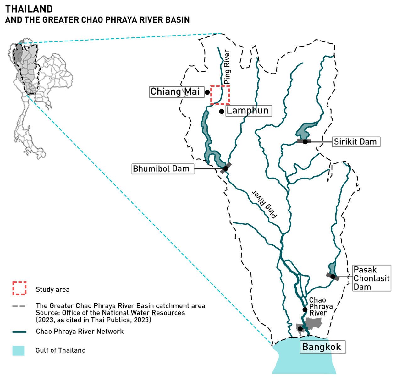
This is particularly evident in Chiang Mai, situated in the headwaters of the Chao Phraya River Basin (
Figure 1), where national directives, spatial planning, and water governance intersect, generating ecological disruptions and governance challenges. Despite decades of state-led development, and current emphasis on sustainability and infrastructure development, national policies often prioritize top-down approaches that inadequately address hydrological variability, ecological interconnections, and socio-ecological contexts. Although water systems are hydro-ecologically interconnected, Thailand’s fragmented governance—with water and land managed separately by multiple agencies, often according to land cover categories, and limited inter-agency coordination—undermines ecological integrity and discourages creative responses to rapid environmental change.
Located in a mountainous region of northern Thailand, Chiang Mai’s landscape consists of approximately 80% mountainous terrain and 70% forested area [
6]. It is critical to national water provisioning, as the source of the Ping River, the main tributary feeding Thailand’s largest irrigation and hydroelectric dam and the Chao Phraya River basin [
7]. National development has driven landscape changes with cascading effects on broader water systems, ecosystems, and livelihoods (see [
8,
9,
10]). While national development policies increasingly emphasize sustainable development with water as a key resource, outcomes often diverge from stated objectives. The Ping River basin is drastically impacted by policy implementation, yet a nuanced understanding of these effects remains insufficiently understood. This is exemplified by the degrading Muang-Fai systems, northern Thailand’s centuries-old community-based irrigation systems that historically governed water distribution for subsistent agriculture in more participatory and context-sensitive ways (see [
11]).
This research investigates how top-down national policies shape water governance and landscape transformations in Chiang Mai, drawing on Mosse’s [
12] framework of policy performance, alongside insights from political ecology, scalar politics, and landscape ecology. Adopting a critical ethnographic approach to the social life of policy [
12,
13,
14], it analyzes how development policies, environmental planning, and spatial governance are implemented in practice, and how broad policy trajectories generate effects and disputes in local contexts. The study focuses on the implications of these transformations for social–ecological systems and local policy implementation, considering state hydrosocial interventions in heterogeneous landscapes, where spatial fragmentation affects ecosystems, biodiversity, and water use systems.
Focusing on contested and evolving riverine landscape governance surrounding the Ping River basin, this research investigates Chiang Mai Province through the Phaya-Kham Muang-Fai system, the largest traditional gravity-based irrigation network in the basin. Located in Chiang Mai’s peri-urban area, the system and its community experience drastic landscape changes, illustrating how national policies materialize locally. Chiang Mai was selected as the primary study area because of its strategic location at the headwaters of the Chao Phraya basin. This renders it a vital and nationally representative site where water supplies, spatial planning, and development pressures intersect. The Phaya-Kham system was chosen as the primary case due to its peri-urban setting, which situates it at the convergence of urban expansion, agricultural intensification, and traditional community governance—factors that illuminate the tensions explored in this study.
The paper draws on research conducted from October 2023 to May 2025. It combines systematic policy document and archival analysis, spatial mapping drawing on national land use data and aerial imagery, fieldwork, and 35 in-depth semi-structured interviews conducted across national, provincial, and local scales. Of the 35 interviewees, 21 were state officials spanning water, land, environmental, and planning sectors; eight were local community members and farmers associated with the Phaya-Kham system; and six were activists and researchers. Participants were selected purposively, with additional participants identified through snowball sampling. Interview material was analyzed thematically and discursively to identify patterns related to institutional fragmentation, scale mismatches, and the gap between policy intentions and outcomes. Documentary data were examined through discourse analysis to trace how sustainability objectives function symbolically across planning instruments. Analytical rigor was strengthened through triangulation across all data sources. All interviews were conducted with informed consent. Given the politically sensitive nature of governance and resource conflicts in the study area, interviewees are identified only by broad actor category and approximate interview period to protect confidentiality within a relatively small governance community. The research thereby addresses the gap between overarching policies and local transformation processes in practice. It emphasizes the understanding of local contexts and power dynamics shaping resource management practices [
12,
15], which may either reinforce or challenge existing inequalities.
This paper inquires how Thailand’s national development policies and planning frameworks influence and legitimize self-confirming approaches to water governance and landscape transformation in Chiang Mai. It argues that current policy implementation is trapped in self-confirming and self-reinforcing vicious circles, reinforced by overlapping mandates and institutional silos. Breaking these cycles urgently requires people-, power- and context-sensitive strategies that consider the diverse socio-economic and ecological factors influencing water governance and distribution. It thereby seeks to offer a nuanced perspective that considers the everyday multi-actor and multi-scale complexities of resource governance and calls for a critical examination of the assumptions underlying conventional spatial planning and water management paradigms in Thailand.
The following section outlines the conceptual framework.
Section 3 examines the relationship between water policy, spatial change, and economic development in Thailand.
Section 4 explores how Thailand’s diverse spatial development pathways influence landscape change in Chiang Mai.
Section 5 analyzes development effects on the Phaya-Kham system on a local scale. Lastly,
Section 6 examines how scalar politics and policy performance interact with landscape heterogeneity. We underscore the need for planning frameworks that address power relations, social-ecological complexity, and local realities.
2. Theoretical Framework
Socio-environmental research increasingly examines human–ecosystem interconnections to tackle growing environmental pressures. Framed as ‘human–environment systems’, landscapes—understood as place-based, hierarchical patch mosaics—become core analytical units [
16,
17,
18,
19]. They represent a critical scale domain where most environment-related decisions are made and where relevant institutions and local or indigenous knowledge are actively applied [
19]. Governance and biophysical processes entwine in shaping landscapes, in the dynamic interplay between naturally and socially constructed spaces [
19,
20].
While landscape ecology provides powerful spatial analysis tools for examining landscape patterns and processes across spatial and temporal scales in landscape governance, it often overlooks the power dynamics underpinning institutional decisions and their ecological consequences. Cumming and Epstein [
21] highlight the need to understand spatially mediated feedback between institutions, governance mechanisms, landscape patterns and processes to sustain a landscape’s capacity to provide long-term, location-specific ecological functions vital for human well-being. They challenge the common assumption in social-ecological studies that institutions influence ecosystems without reciprocal effects. Turner and Robbins [
22] equally argue for the need for a more detailed analysis of the workings of power in land change sciences, yet such research remains rare and is seldom spatially explicit. This gap calls for integrating political ecology with landscape governance to better understand how power influences environmental outcomes and policy.
Political ecology provides important conceptual tools and reveals that development policies are both technical and political instruments. Ferguson’s [
23] influential critique of development projects as an “anti-politics machine” demonstrated how technical framings depoliticize complex issues such as poverty and marginalization (see also [
24]), obscuring how power relations extend state authority. Building on this, subsequent works show that policies are socially and politically constructed, continually reshaped through the actions, relationships, and negotiations of actors in practice (e.g., [
12,
25,
26,
27,
28]). Mosse [
12,
13,
29], for instance, highlights how, first, development practice is driven more by organizational culture and complex relational networks than by policy itself. Second, policies are political and social processes, often functioning as symbolic tools for mobilizing support, securing funding, and coordinating actors, and shaped more by institutional constraints and relationships than by practical implementation. Third, frontline actors reshape policies by actively creating the appearance of policy success to maintain legitimacy and funding, despite actual outcomes that often diverge. Fourth, development success relies heavily on relational networks among various actors, including donors, government agencies, and local communities, who mediate the interpretation and enactment of policies. Consequently, understanding and supporting the social processes of implementation is more critical than labeling projects as ‘successes’ or ‘failures,’ as such assessments oversimplify their on-the-ground effects. As Mosse [
12] (pp. 663–664) stresses, “Projects are successful because they sustain policy models offering a significant interpretation of events, not because they turn policy into reality. In this way the gap between policy and practice is constantly negotiated away.”
Building on this critique, Mosse [
13] critically reframes development discourses as a tool to sustain state top-down power dynamics. Knowledge and policies guiding development are socially constructed through the daily practices and interactions of people involved [
12,
29] (see also [
30]). Although widely used in development, water governance and political ecology studies (e.g., [
31,
32,
33,
34]), these insights remain underutilized in landscape research, despite their potential to explain how institutional actions influence spatial configurations. Incorporating these insights into landscape governance can help uncover how institutional power and political incentives reshape landscapes through sustainability or progress discourses. This reflects a pervasive “will to improve” [
35] operating as an ideological force. It shapes the actions and discourses of various actors and legitimizes interventions that often extend state or market control regardless of a project’s on-the-ground success or ecological and social outcomes.
The hydrosocial territory framework [
36] emerging from political ecology provides a valuable lens for examining the techno-politics and cultural-institutional power dynamics shaping water-centered landscapes. It investigates the contested spatial configurations of humans, water flows, institutions, technologies, and biophysical environments formed around and interwoven through water. These spatial configurations shape and are shaped by a variety of physical, social, political, and symbolic dimensions, resulting in the active production of territoriality. Thus, the framework provides analytical insights in multi-actor and multi-scalar territory-based techno-political and socio-ecological interactions, struggles and power dynamics (see [
37,
38,
39,
40]). More specifically, as Boelens et al. [
36] (p. 427) elaborate, the framework allows “analyzing, and potentially changing, claims of authority over a space, its waters and human and nonhuman beings—an analysis in which space and colliding space-making claims are understood as material–geographic, social–political, cultural and symbolic.” Concurrently, people shape their physical environments by utilizing, inhabiting, and managing them based on their ideologies, knowledge, and socio-economic and political power.
Landscape patterns, expressed through landscape heterogeneity and connectivity, thus reflect diverse imaginaries, ideologies and interests concerning the realization of hydrosocial territories. Hydrosocial territories analysis, for that, adds to Mosse’s [
12,
29] perspective. It has the “explicit aim to read and follow power and politics in waterscapes, thereby repoliticizing water and space,” and seeks to unmask different power mechanisms, including through governmentality analysis. It thereby is both “an academic-analytical endeavor but also crucially a political project…” [
36] (p. 428). In this transformation process, policy-actors aim for particular hydro-territorial transformation, and policy-embedded power dynamics are performative. This perspective complements Mosse’s [
29] argument that development policy proposes, devises, incentivizes, validates, and approves particular institutions in self-confirming, circular ways, driven by a persistent ‘will to improve’ [
35].
Hereby, scalar politics play a central role in shaping landscapes. Different actors manipulate scale rhetorically and institutionally to assert control, often privileging dominant interests over others [
41,
42,
43,
44]. Scalar politics operate from both above and below (see [
45,
46,
47,
48]), and critical institutional approaches further reveal how formal governance reforms often reproduce rather than challenge existing power arrangements [
49,
50], reflecting how state institutions are themselves socionatural effects shaped by power dynamics [
51]. But planning and policy, including those with landscape ecological approaches, consider spatial and temporal scales in strongly apolitical ways (see [
52,
53]). Relational and political approaches (such as the above hydrosocial territories approach) can contribute by providing understanding of how landscapes are socially constructed, contested, and reconfigured through everyday actions that extend beyond physical boundaries, including river landscapes. They emphasize networks, connectivity, and human/nonhuman dynamic interactions [
42,
54,
55]. They show how various actors use rhetorical claims about scale to further their own agendas, with the relative power and strength of these actors determining which scales dominate analysis and decision-making [
41,
44]. This echoes Mosse’s [
12] observation that development projects—here, dominant hydroterritorial and institutional arrangements—strive to preserve their consistency as policy ideas and representational systems to normalize the operational systems they consider convenient.
The choice of scale in scientific assessments of environmental changes is therefore inherently political, shaped by both biophysical attributes and political factors [
41]. Combining Mosse’s insights with hydrosocial territory analysis enables critical scrutiny of landscape governance and scalar politics engaged in landscape changes. In Thailand, the production and governance of landscapes, especially around river systems, are embedded in scalar struggles among state agencies, communities, and markets. These scalar politics influence whose knowledge counts, how plans are formulated, and which landscapes are prioritized or marginalized. Recognizing these dynamics is crucial for understanding the Ping River landscape in Chiang Mai, where diverse imaginaries of hydrosocial development coexist and compete. These dynamics are further illuminated by research on multi-scalar water governance that shows how hydro-scalar negotiations shape resource control across governance levels [
56,
57,
58]. By examining narratives, knowledge claims, and governance mechanisms across spatial and temporal scales, the research aims to provide a more integrated understanding of how land/waterscapes are governed and contested in practice.
3. Spatial Changes, Water Policy and Economic Development: From Policy to Practices
Thailand has long identified itself as an agricultural country [
59], with over one-third of the populations engaged in agriculture, and farmlands covering more than 40% of its land area [
60]. Today, agriculture, industry, and tourism underpin national economic growth, with urbanization serving as the principal development trajectory [
61].
Currently, Thailand’s development framework is structured as a cascading hierarchy of plans: the 20-year National Strategy (NS, 2018–2037) as the primary development framework, the five-year National Economic and Social Development Plans (NESDPs) as the second-tier framework, and their sector-specific implementations at the agency level. This emerges from decades of economic-priority planning since the first Economic Development Plan in 1961, which later became NESDPs [
62], with the NS launching in 2018 as the first constitutionally mandated long-term development framework. Today’s frameworks are framed around sustainability, well-being and social equity, governmental efficiency and environmental quality [
61,
63]. Currently, the 13th NESDP (2023–2027) translates these objectives into quantitative milestones measurable within its fixed five-year cycles, including targets for water supply expansion and annual reservoir inflows, growth in certified and organic agricultural areas, and smart city development [
63]. While ambitious, these indicators are broad and emphasize numerical outputs, limiting sensitivity to contextual and socio-ecological complexities. Global environmental discourses, including the Sustainable Development Goals and participatory resource governance, further inform state approaches across scales. While sustainability terminology is widely incorporated into national frameworks and agency visions, these guiding frameworks remain broad and unspecific, functioning more as legitimizing language than actionable plans.
These frameworks are primarily implemented through Thailand’s three-tier administration system—central, provincial, and local [
64]. While there are regional offices working on these frameworks, regional authorities function primarily as regulators rather than implementers, leaving substantive decision-making to central authorities and local actors (pers. comm., government officials, 2024–2025).
Socio-economic developments directly reshape spatial patterns, ecosystems, resource uses, and livelihoods (see [
9,
65,
66,
67]). Despite decades of rapid economic growth [
68] and nationwide rapid urbanization [
69], Thailand’s spatial development frameworks have lagged, with policies guiding comprehensive spatial planning remaining weak and fragmented [
69,
70]. This uneven development has produced Bangkok as the sole primate city [
71]. Although NESDPs recognized regional imbalance, economic growth has largely proceeded without formal national or regional spatial policies to guide or regulate the developments [
64]. Centralized governance, insufficient preparatory studies, and weak inter-agency collaboration have further contributed to fragmented and impractical land use strategies, generating persistent issues in spatial development and natural resource management [
64,
72].
In 2002, the Department of Public Works and Town and Country Planning (DPT) under the Ministry of Interior (MOI) was tasked with nationwide urban planning and developing the National-Regional Plan to guide spatial development [
64]. The plan outlined a 50-year vision to 2057, with shorter-term strategies emphasizing sustainable growth, quality of life, and regional and international integration [
64]. However, inconsistencies with other policies and local contexts drew public criticism [
73,
74]. Although amendments were later proposed to align the plan with the first NS [
75], it remains under revision and has yet to be enforced (pers. comm., planner, March 2025).
Within this fragmented planning context, Thailand’s land cover is commonly classified into five key types: urban and built-up land, agriculture, forest, water bodies, and miscellaneous land [
76]. Each is governed under separate jurisdictions, complicating coordination, particularly for spatial and water management in rapidly urbanizing regions. As economic development accelerates, these spatial changes and institutional arrangements significantly influence land use patterns and water governance outcomes across Thailand.
Currently, land use strategies and regulating policies are dispersed across multiple bodies spanning 20 ministries, primarily under the Ministry of Natural Resources and Environment (MNRE), MOI, and Ministry of Agriculture and Cooperatives (MOAC). Broadly, MOI agencies are responsible for land administration and statutory land use planning, primarily in urban areas; MNRE governs forests and designated protection and conservation zones; and MOAC oversees agricultural land and agricultural zoning development. Additionally, sectoral agencies, such as those under the Ministry of Transport (MOT) or the Ministry of Industry, also influence physical landscapes through situational and project-based interventions (see
Table 1).
Water governance reflects similar fragmentation. Despite hydrological connectivity, responsibilities are divided among multiple agencies with competing sectoral interests. Key institutions include the Royal Irrigation Department (RID) under the MOAC, which manages irrigation zones and key surface water sources, while under the MNRE, the Department of Water Resources (DWR) oversees surface water beyond irrigation zones, and the Department of Groundwater Resources (DGR) regulates groundwater. To address this, Thailand established the Office of the National Water Resources (ONWR) in 2017 as a central agency to regulate and oversee policies for integrated national water resource management. It enacted the first National Water Resource Act in 2018 and National Water Resource Master Plan B.E. 2561–2580 (2018–2037) [
77]. The 20-Year plan serves as Thailand’s overarching strategy for long-term water governance, emphasizing domestic supply; production and economic activities; flood and drought management; water quality and aquatic ecosystem conservation; and forest and upstream watershed management for ecological balance and strengthening institutional coordination and stakeholder participation [
77]. These frameworks aim to balance ecological sustainability with economic development and equitable water resource management.
ONWR consolidated multiple agencies into the Prime Minister-chaired National Water Resource Commissions (NWRC), composed mainly of appointed members, through which all water-related projects nationwide must undergo approval and budget allocation via the centralized “Thai Water Plan” system [
78]. The ONWR also produces a spatial database indicating the water system and hydraulic infrastructure nationwide (pers. comm., government official, July 2024). The Water Act and water agenda are thus firmly under ONWR’s jurisdiction. The NWRC also codifies national water allocation priorities as follows: (1) Consumption; (2) Ecosystem preservation; (3) Disaster relief; (4) Traditions; (5) Transportation; (6) Agriculture; (7) Industry; (8) Commerce; and (9) Tourism [
79].
Despite this reform, implementation remains largely with pre-existing agencies. Although inter-agency collaboration has improved, genuinely integrated strategies remain elusive—with many local state officers reporting that they operate in isolation from other agencies (pers. comm., government officials, July–August 2024). Centralized frameworks clarify priorities and budgetary mechanisms but also reinforce a top-down approach that often sidelines local contexts. Ultimately, water remains governed separately from land under overlapping jurisdictions. Freshwater, groundwater, wastewater, and seawater are administratively segregated, whereas rivers and public waterways are governed by multiple authorities despite their physical connectivity. Moreover, spatial planning gives limited attention to water resource and flood management plans [
70].
Agriculture—which accounts for roughly 75% of national water use [
80]—involves multiple agencies, each often seeking additional sources to meet the demands. Additionally, rapid urbanization and industrial expansion further strain water systems, affecting water availability and exacerbating issues related to flooding, droughts, wastewater management, and the natural processes in watershed forests, including soil erosion. Consequently, water management strategies must grapple with meeting sectoral demands while managing broader landscape transformations driven by shifting water availability and use.
4. Thailand’s Spatial Development Pathways and Landscape Changes in Chiang Mai
Thailand’s developments have long been propelled by resource extraction and infrastructural expansion, converting natural resources into commodities for economic and political gain since the 1800s [
81,
82]. These processes have significantly reshaped landscapes, livelihoods, and patterns of natural resource use, a dynamic that continues today.
In Chiang Mai, these fragmented development frameworks continue to shape landscape change, transforming social, ecological, and hydrological systems locally, with cascading downstream impacts across the greater Chao Phraya River system. Although development proposals are formally required to align with the NS, its broad and non-specific directives allow flexible interpretation; as an officer noted, “you can easily set any goals to meet those requirements” (pers. comm., government official, July 2024). Developed within these broadly defined frameworks, Chiang Mai’s Provincial Strategic Plan 2023–2027 (2566–2570 B.E.) prioritizes economic growth—driven by tourism, value-added agriculture, and the creative economy—as central to improving quality of life [
83].
Projects in Chiang Mai framed under “sustainable” narratives often focus on short-term initiatives aimed at meeting annual targets, with limited contribution to long-term objectives. Interviewees attributed this tendency to fiscal-year budgeting practices, which require agencies to spend allocated funds within the fiscal year (pers. comm., government officials, July–August 2024). As agencies compete for budgets, projects are frequently designed to secure funding rather than address long-term challenges. This multi-agency involvement has produced rapid, unpredictable spatial development and resource management, outpacing state oversight and generating significant environmental impacts (pers. comm., activists and researchers, July–August 2024).
The following subsections analyze spatial governance in Thailand concerning water management, with particular emphasis on Chiang Mai and the Ping River Basin. The analysis employs standard state land cover categories to examine their impact on water systems, governance, and environmental change.
4.1. Built-Up Areas
For decades, Comprehensive Plans prepared under the DPT’s Town and Country Planning Act (TPA) B.E. 2518 (1975) formed Thailand’s main spatial planning framework. These five-year plans regulate urban land use through color-coded zoning schemes for private development and traffic management [
72], while excluding most of the country and neglecting essential infrastructure such as drainage, wastewater treatment, and parks [
84]. Additionally, plan preparation and approval often exceed the intended five-year enforcement timeframe, creating gaps where expired plans remain unreplaced [
69]. The Act also permits discretionary zoning changes under vaguely defined “public benefit” clauses, allowing influential actors to override existing plans and regulations [
3,
85]. These vacuum periods and discretionary powers contribute to urban sprawl and investor-driven zoning adjustments [
69], with large-scale landowners and private sectors frequently influencing zoning decisions to serve their interests (pers. comm., planners, July 2024).
To foster integrated urban–rural development, the 2019 TPA replaced the 1975 Act, with a three-tier system comprising national, regional, and provincial plans, supported by maps outlining infrastructure, special zones, resources and conservation areas. However, state interviewees see these supporting plans as remaining broad and lacking regulatory strength (pers. comm., government officers, July 2024). Despite holistic ambitions, planners indicated the 2019 TPA is undermined by fragmented agency operations and bureaucratic inefficiency, leaving spatial and resource management challenges unresolved (pers. comm., planners and government officials, July 2024). Public engagement remains minimal: the DPT-organized hearings are largely consultative rather than participatory decision-making. Most officials reported low engagement in planning processes, and the sense of institutional disconnection extends within agencies themselves (pers. comm., government officials, July–August 2024). One state officer in the water sector noted, “it is not our missions, and we do not see ourselves as a part of the planning processes” (pers. comm., government official, July 2024). While spatial plans under the 2019 Act are currently undergoing revisions and approvals, many existing Comprehensive Plans nationwide have already expired (pers. comm., planner, July 2024). This illustrates how the planning system, with complex legal and administrative procedures, often legitimizes industrial and urban-capitalist development rather than effectively regulating it.
Beyond TPA-regulated zones, rural areas are often unmapped and loosely governed by municipal ordinances without formal spatial development frameworks. Other land use types (e.g., conservation and agriculture) fall under separate authorities, with unclear jurisdictional boundaries and limited inter-agency coordination, with agencies maintaining separate sectoral datasets (pers. comm., government officials, July–August 2024). In Chiang Mai, sprawls typically follow road corridors or agricultural zones due to cheaper land costs and legal loopholes [
11]. Urbanization also intensifies due to tourism development [
9]. Yet the involved agencies, including agricultural, tourism, and highway authorities, exhibit limited engagement with spatial planning processes.
Fragmented governance also facilitates the misuse of state lands. For instance, the government allocates lands known as Sor-Por-Kor (agricultural land title deeds for agricultural use) to landless or low-income farmers for agricultural use under the Agricultural Land Reform Act B.E. 2518 (1975). Though these lands are state-owned and legally non-transferable, they are often illegally sold or converted into non-agricultural uses such as residential or commercial uses [
86]. Informal settlements similarly expand outside planning oversight, creating social and environmental pressures (see [
87]).
Community-based planning initiatives to manage rural developments also exist across agencies, but remain largely advisory rather than enforceable (pers. comm., July–August 2024). Such projects include ecological management plans under the MNRE and the MOI’s village-level planning projects (pers. comm., government officials, July–August 2024). An officer involved in a recent nationwide village planning project described these initiatives as impractical, calling them “another window-dressing project” (pers. comm., government official, July 2024).
Infrastructure and environmental management in built-up areas also reveal significant implementation gaps, despite state policies promoting holistic and environmentally responsible development. For instance, developments near highways frequently exploit the road infrastructures beyond their intended capacity, causing pollution from inadequate sewerage and waste management systems, yet agencies responsible for these developments neglect accountability (pers. comm., government officials, July 2024). As one state actor observed, “urban expansions along these corridors are approved without adequate sewage provision, ultimately overburdening systems designed solely for highway” (pers. comm., government official, July 2024). Despite these overlaps, highway agencies have minimal involvement in broader spatial planning process, citing their organizations’ primary focus on road design and construction for traffic and connectivity (pers. comm., government officials, July 2024). Moreover, although highway agencies claim road designs are context-specific, feasibility studies are typically commissioned by their Bangkok headquarters, conducted by external consultants using standardized criteria, with limited local input (pers. comm., government officials, July 2024). These top-down designs often prioritize engineering solutions to local site constraints, such as roads elevated above flood levels in low-lying areas to prevent flood damage but inadvertently acting as dikes that obstruct water flow [
11]. Although highway officers argued road culverts suffice for water passage (pers. comm., government officials, July 2024), community members reported these roads often obstruct the flows, causing prolonged floods, and culverts are often undersized for the flow (pers. comm., Chiang Mai residents, June–August 2024). Ultimately, despite local officers often possessing more grounded knowledge of on-the-ground conditions, design and planning roles remain centralized at headquarters, leaving local departments confined to road maintenance responsibilities—including the management of flood-affected sections (pers. comm., government officials, July 2024).
In built-up areas, flooding is the primary water-related concern, with multiple agencies—including the DPT, RID, and local municipalities—responsible for mitigation. The DPT designates flood-prone zones in the Comprehensive Plans (pers. comm., planner, July 2024). However, this strategy has proven ineffective in mitigating floods in high-risk zones, such as Chiang Mai’s business districts along the Ping River, where economic priorities override restrictions. As one state officer noted, “…due to the economic purposes, we have to leave it like that” (pers. comm., government official, July 2024).
By contrast, water supply in Chiang Mai is treated as secure, while wastewater receives limited attention. The Provincial Waterworks Authority provides potable water in urbanized zones, primarily relying on sources managed by the RID, while areas outside its coverage rely on local groundwater sources regulated by the DGR and local municipalities. Wastewater is usually handled by the local municipalities under the MOI, whereas wastewater in the large-scale buildings falls under a local environmental authority operating under the MNRE (pers. comm., government officials, June 2024). Meanwhile, waste management, including waste entering waterways, is overseen by the Ministry of Public Health, and industrial wastewater by the Ministry of Industry.
Although these agencies are involved in water-related planning, they commonly assume that water demand will be met and wastewater does not constitute an urgent policy issue. These assumptions are reinforced by persistent data gaps and inconsistencies, as the ONWR’s water maps—still pending official release—are often outdated or misaligned with current spatial plans (pers. comm., planners, June–July 2024). Together, overlapping mandates, institutional silos, and weak coordination generate unresolved grey areas in water governance, with significant consequences for landscapes.
4.2. Agricultural Areas
Agriculture, Thailand’s largest sector, significantly shapes landscapes. While recent policies emphasize sustainable approaches, implementation remains inconsistent across agencies. Several institutional tools under the MOAC offer agricultural planning guidance. Agri-Map, the online national agricultural map, defines suitable zones for different types of agriculture [
88]. The Land Development Department [LDD], another MOAC department, provides maps and datasets on soil types, land cover, and agricultural water sources, categorized into subtypes. These datasets constitute essential cartographic resources for multiple state authorities, including the DPT (pers. comm., government official, March 2025). Yet, these tools remain advisory and lack legal enforceability (pers. comm., government official, July 2024). Officials acknowledged that although agencies rely on LDD data, they often use only the basic layers, omitting subcategories necessary to capture landscape complexity. Similarly, key agricultural acts function as guidelines rather than binding regulations, leaving farm-level planning largely in limbo and subject to market forces. “We can’t control the farmers. The role of agencies is limited to providing assistance rather than directing agricultural decisions,” one official remarked (pers. comm., government official, July 2024).
Policy directions are also unstable, shifting with ministers and officials assuming office, often following election promises, with limited consideration of broader environmental impacts: “They often change based on who is elected into positions” (pers. comm., government official, July 2024). The Agri-Map, for instance, suggests economically viable crops suited to local ecological conditions and water availability based on MOAC’s research. In practice, however, “farmers tend to cultivate prevailing cash crops aligned with current price guarantee programs, often regardless of local ecological suitability or water availability” (pers. comm., government official, July 2024). Similarly, related legislation inadequately regulates water or chemical use in agriculture. While national development policies emphasize environmentally responsible agricultural practices, the MOAC’s campaigns often promote specific methods or market-oriented crops without any geographical controls. “We cannot prohibit farmers from cultivating specific crops; we can only encourage them to grow those in demand or with strong market value” (pers. comm., government official, July 2024). Interviews indicate the state largely responds to farmers’ choices rather than enforcing restrictions on agricultural inputs and environmentally responsible practices. However, “when crops are widely produced, prices are regulated by market mechanisms, and farmers are responsible for managing surpluses and associated risks” (pers. comm., government official, July 2024).
The Chiang Mai flood in 2024 revealed the significant presence of agricultural chemicals in the environment, raising concerns over water quality. Floodwater carried high chemical loads from the Ping River, causing visible ecological disruptions in the Phaya-Kham irrigation system and surrounding areas. “Weeds and grasses turned yellow and died within days. The floodwater had a strong odor. After it receded, insects in the soil disappeared,” (pers. comm., farmer, March 2025). Laboratory analysis of soil samples confirmed elevated sodium levels, commonly associated with herbicides. An ecologist explained that agricultural chemicals released into natural systems often structurally transform and bind with other elements in soil and water, leaving only elevated elemental concentrations detectable, and making the original compounds difficult to trace (pers. comm., researcher, June 2024). These findings highlight the complex, interrelated challenges of land and water management. Despite these issues, agricultural waste management remains a low priority for state authorities.
Groundwater exemplifies another regulatory gap, often treated as an alternative and unlimited agricultural resource without proper control. Consequently, borewells are frequently constructed without government permission, including in Chiang Mai. Outside the RID’s irrigation zones, agricultural agencies reported implementing projects to develop groundwater wells for agricultural purposes as an organization target (pers. comm., government officials, July 2024). Although parts of Chiang Mai report the depletion of groundwater in recent decades, responsible agencies continue to consider current usage levels acceptable (pers. comm., government official, July 2024). While one local officer acknowledged water table reductions of around 5 cm in some areas (pers. comm., government official, July 2024), elderly farmers in peri-urban Chiang Mai observed that groundwater levels are visibly lower than they were in their youth (pers. comm., farmers, 2024–2025), reflecting a deeper experiential knowledge of landscape change that formal monitoring fails to capture.
Similar regulatory gaps are evident in animal husbandry and aquaculture, both classified as agriculture under the MOAC’s jurisdiction. Economically valuable species are often cultivated intensively without sufficient oversight and minimal ecological regulation. The Department of Fisheries (DOF), also under MOAC, promotes cage culture in natural water bodies—now widespread nationwide, including the Ping River system. Despite this, officials acknowledge limited information and regulatory authority to assess the ecological impacts of introducing non-native species into natural streams (pers. comm., government officials, June–July 2024). The DOF maintains that cage-based farming does not pose environmental risks, as the fish are confined. As one official remarked, “The farmers would incur substantial losses if the fish were released from the cages” (pers. comm., government official, July 2024). This reflects a broader trend within agricultural agencies to prioritize economic output over social and environmental consequences, which current laws and regulations inadequately address. Farmers often exceed physical and ecological limits to maximize profits, while state policies, including price guarantee programs, inadvertently amplify environmental and societal challenges.
4.3. Forest Areas
Under the MNRE, forests are classified into two main categories: protected areas—including national parks, wildlife sanctuaries, and other sub-types managed by the Department of National Parks, Wildlife and Plant Conservation—and reserved forests overseen by the Royal Forest Department. Each category is regulated under separate legal frameworks, despite ecological and physical connectivity. Roads, waterways, and other infrastructure within forest areas often fall under other agencies, creating overlapping mandates and inconsistent regulations. Fragmented jurisdictions have created overlapping official boundaries [
89], complicating management and enforcement. For example, some national parks—legally prohibiting human activities—overlap with Sor-Por-Kor lands or reserved forests, where limited use is permitted. Thailand launched the One Map initiative in 2019, aiming to integrate state land boundaries into a unified database for consistency and standardize guidelines across agencies [
89]. Yet, implementation remains incomplete (pers. comm., government official, July 2024). These inconsistencies have produced unclear land rights, and conflicting mandates between conservation and development objectives.
Approximately 10–12 million people nationwide live within forest areas [
90], including over 1000 villages in Chiang Mai, primarily in the uplands (pers. comm., activist, April 2025). These communities, particularly indigenous groups, have longstanding dependence on forests, often predating conservation laws introduced in the 1960s (pers. comm., activist, April 2025). Traditionally, they practiced rotational swidden agriculture, alternating cultivation with fallow periods that allowed the land to recover for future use [
91]. This method sustained both livelihoods and ecosystems, with communities actively protecting fallow vegetation from bushfires to maintain its suitability for future cultivation (pers. comm., activist, April 2025). Conservation laws disrupted these practices by establishing protected areas with strict prohibitions on human activity, while reserved forests permit only limited use. State policy further prohibits traditional swidden practices by allocating Sor-Por-Kor lands in the forest area, limiting agricultural areas available to forest communities. Consequently, many continue to use forest land illegally, increasingly adopting intensive swidden practices focused on cash crops and monocultures in response to socioeconomic pressures (pers. comm., activist, April 2025). Laws intended to protect forests and minimize human impact have thus fueled conflicts over overlapping land uses, restricted community participation in forest governance, and limited access for forest-dependent populations. Conversely, these measures often promote market-oriented, intensive agriculture and modernization [
86,
92]. As one activist noted, excluding long-term forest populations from decision-making undermines both livelihoods and the regulation of human activity in forests (pers. comm., activist, April 2025).
Forest governance also intersects with water governance. Current water policies prioritize restoring degraded headwater forests and preventing soil erosion, but “…neglect strategies for sustaining pristine forests that generate water” (pers. comm., government official, April 2025). Policy discussions often center on national water allocation figures, while the actual volumes generated in upstream forests remain unknown (see [
93]). Current practices rely on theoretical estimates based on forest cover and precipitation data. “In reality, water flowing from these forests into the dams is being used all the way. We should know how much water we should use from the upstream” (pers. comm., government official, April 2025). Meanwhile, agricultural areas within forest communities often fall outside the agricultural authority oversights, as the land is legally classified as forest, whereas forest officials lack agricultural expertise (pers. comm., government official, April 2025). This jurisdictional gap is compounded by the largely advisory and unenforceable nature of agricultural policies, which leaves ecologically sensitive forest areas particularly vulnerable to intensification pressures. Under market-driven capitalist developments, this has enabled widespread agricultural intensification and extensive agrochemical use with broader ecological consequences that cross jurisdictional boundaries and remain largely unregulated (fieldwork observations, 2023–2025).
State land classifications further complicate governance. Grasslands, groves, and bamboo forests are often classified as abandoned or degraded lands—usually placed under ‘miscellaneous’ categories—overlooking their ecological functions, dynamics, and sensitivity. Such areas are frequently reallocated as Sor-Por-Kor lands or targeted for reforestation (pers. comm., government official, June 2024). Concurrently, large-scale reforestation efforts focus on increasing forest cover to meet institutional performance targets, often annual goals, despite ecological processes requiring far longer to mature. One officer stated, “…they only focus on measurable outputs, not the outcome” (pers. comm., July 2024).
Research has shown that expanding forest cover in upland watershed areas can reduce both groundwater recharge and surface water flows downstream, thereby diminishing water availability for other uses [
94,
95,
96]. Nonetheless, Thailand’s development policies continue to tie forest cover targets to annual planning and budgeting cycles. Forest communities are confined within reserved forest areas and required to maintain buffer zones with state-prescribed vegetation, which often become afforestation project sites (pers. comm., activist, April 2025). Thailand’s carbon neutrality initiatives further promote afforestation, often using fast-growing invasive species, such as
Acacia auriculiformis, approved for carbon credit schemes (pers. comm., government official, April 2025). Private donors and companies use these projects to earn carbon credits for state tax reduction. While achieving these targets is prioritized, one state officer noted “the budgeting system undermines forest resilience” (pers. comm., government official, April 2025), underscoring the tension between short-term fiscal cycles and long-term ecological processes.
Contradictions also arise in development projects. While forest communities face restrictions on Sor-Por-Kor lands, state agencies often secure permits for water infrastructure projects, such as concrete check dams, and pipelines in ecologically sensitive areas, often drawing directly from natural sources and citing community development needs (pers. comm., government official, April 2025). Such interventions often proceed without adequate environmental assessment, risking disruption to natural water flows and ecosystem functions in ostensibly protected areas (pers. comm., activist and researchers, 2024–2025). This occurs despite forest authorities claiming that such infrastructure should support ecosystem restoration and preservation, revealing fragmented and uncoordinated environmental governance that produces policy contradictions and governance gaps in practice.
4.4. Water Bodies
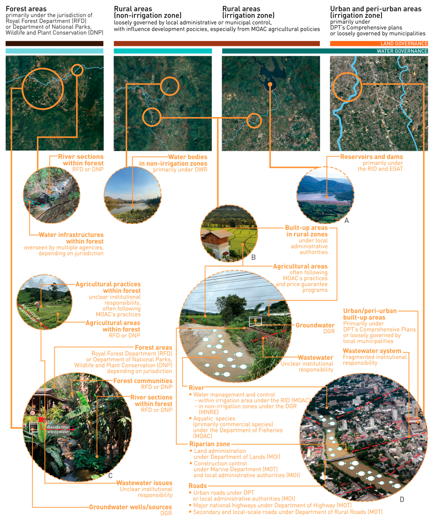
Water bodies in Thailand are governed by multiple agencies exercising overlapping jurisdictions and limited coordination over the same water systems, often under different land-cover and functional classifications. Irrigation zones, non-irrigated areas, forests, riparian infrastructure, land administration, water quality, and aquatic species fall under separate institutional mandates, often requiring complex multi-agency approvals (see
Figure 2). This compartmentalized governance prioritizes economic and infrastructural functions over ecological dynamics, resulting in the structural neglect of freshwater and riparian ecosystems, as one aquatic ecologist observed: “They don’t care about the aquatic species in the river” (pers. comm., ecologist, June 2024). This neglect has tangible ecological consequences, as government interventions progressively alter the biological foundations of river systems.
This fragmentation reinforces a commodified view of water. Although national policies, including the Water Resource Master Plan, promote sustainability, implementations prioritize fundable, measurable interventions with quantitative, human-centered targets over long-term ecological functions. National water allocation frameworks rank consumption above ecosystem preservation [
79], which in practice means maintaining minimum dry-season flows rather than sustaining broader ecological processes. Fiscal-year budgeting pressures further incentivize quick, measurable outputs. At the provincial level, water system development, particularly small reservoir construction, is promoted as an environmental solution for social and economic growth by increasing water supply [
83], reflecting broader trends of contested hydraulic infrastructure development [
102]. Yet, officials struggle to identify additional surface water sources to meet rising demand (pers. comm., government officials in water sector, 2024–2025).
Today, wetlands, marshes and swamps are increasingly recognized as key water sources (pers. comm., July 2024). Although frequently classified as “miscellaneous” land under the state system, they have officially fallen under the DWR’s jurisdiction since 2009 and are primarily managed through dredging. Officials stated that “nature-based solutions” now guide wetland management, with dredging serving as a "nature-based", soft-engineering approach (pers. comm., government officials, July 2024). One officer explained, “Earlier dredging designs focused on water storage, whereas current approaches emphasize the human-nature coexistence—favoring organic shapes over rigid square ones and using natural materials instead of concrete” (pers. comm., government official, July 2024). Despite their ecological importance [
103], fiscal-year targets constrain broader ecological objectives, limiting wetland management to short-term dredging interventions.
Current management of water bodies heavily relies on engineering solutions and hard infrastructure, seen as the fastest way to meet fiscal-year targets (pers. comm., government officials, 2024–2025). However, the real-world impacts are not monitored or seen as less important. The ONWR allocates national budgets for water-related projects through the “Thai Water Plan” portal, requiring different authorities to submit proposals for approval and funding within each fiscal cycle (pers. comm., government officials, July 2024). This project-based funding system further reinforces infrastructure-led approaches, particularly during crises. Chiang Mai’s 2024 floods illustrate how crises trigger surges in state-led infrastructure projects, with floodwalls and river dredging prioritized as the primary solutions of water(-related) authorities based on available budgets, while long-proposed upstream reservoir projects were also revisited.
Officials identify climate change and encroachment into floodplains and waterways as major contributors to recent flooding, yet these issues remain largely unaddressed despite official awareness (pers. comm., government officials, 2024–2025). Meanwhile, landowners in low-lying areas commonly rely on earth-filling and floodwalls as flood protection measures (pers. comm., Chiang Mai residents, 2024–2025), reinforcing risk exposure elsewhere. Although the ONWR proposes flood zoning maps nationwide, they remain under revision and pending approval due to anticipated political resistance and potential challenges to property rights and land values (pers. comm., government officials, March 2025). Dominant players’ modifications of the river’s dynamic channels further challenge management. Another officer admitted avoiding discussions of waterway encroachment in meetings due to limited institutional support and political repercussions (pers. comm., government official, February 2025), reflecting institutional reluctance to challenge powerful actors.
Without clear boundary maps, zoning indicators, or ecological safeguards, ecologically sensitive areas such as riverbanks, wetlands, and forests are highly vulnerable to legal and illegal alterations and encroachment. For instance, Thai law grants ownership of newly formed alluvial land along rivers to adjacent landowners, yet the ecological importance of riparian zones is seldom addressed in official narratives (pers. comm., government officials, June–July 2024). A state officer working in environmental management openly indicated, “riparian zones had not previously been considered within our concern” (pers. comm., government official, June 2024). This reflects a broader pattern in which both private and public actors modify riparian zone and other types of ecologically sensitive areas under weak regulatory oversight.
The Ping River system, home to several endemic species, has been largely neglected by the state, with contemporary farming and development practices severely impacting river ecology. An aquatic ecologist noted, “The upstream of the Ping used to have a lot of endemic species. Natural stones in the river contain many microorganisms crucial to the river system—when rivers are dredged, these stones disappear, removing the food source for everything else in the river” (pers. comm., ecologist, June 2024). New developments—including concrete floodwalls and dredging to accelerate flood-season flows (pers. comm., activists, 2024–2025)—have further altered river landscapes. Floodwalls, varying in height and design, are constructed by different agencies in response to local petitions [
11]. Ahead of each fiscal year, many residents petition authorities to construct floodwalls to protect property, prompting these agencies to allocate budgets for construction. Wastewater management remains minimal, with one officer noting, “Resolving this is time-consuming and costly. No one wants to take responsibility for this” (pers. comm., government official, September 2024).
Today, state preference for engineered solutions remains strong, because they are “achievable within a one-year fiscal budgeting period, unlike slower, less practical ecological measures” (pers. comm., government official, June 2024). Consequently, critical areas such as riparian and freshwater ecosystems continue to be marginalized, accelerating environmental degradation and undermining local livelihoods.
5. Holistic Efforts or Chaotic Process: Development and Landscape Changes in Chiang Mai and the Phaya-Kham System
Historical evidence shows that Chiang Mai and surrounding regions have limited water resources due to geographical constraints, identified in early spatial planning as a critical development trajectory [
104]. Today, development in Chiang Mai largely follows state-defined narratives, with “water efficiency” dominating water management discourse amid rapid landscape changes.
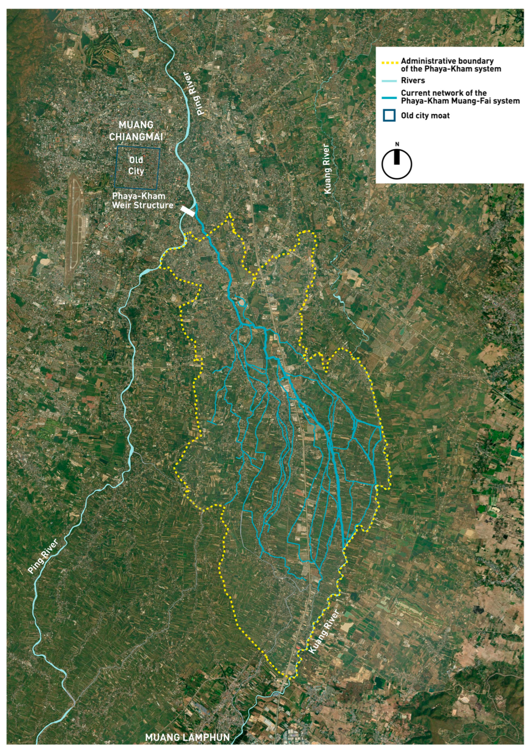
The Phaya-Kham irrigation system, a centuries-old Muang-Fai system in Chiang Mai, exemplifies how national and regional policies materialize locally. Historically, it was sustained through community-based arrangements regulating seasonal rice farming, collective canal maintenance, and fishing in irrigation channels, enabling collective water management within available flows. Today, however, state policies, urban pressures, and shifting agricultural markets have deeply reshaped the system (see
Figure 3).
Under centralized water governance, the Electricity Generating Authority of Thailand (EGAT) oversees water regulation in large-scale reservoirs and the RID controls most river systems and reservoirs, together serving as the primary authorities managing Thailand’s water supply (pers. comm., government official, July 2024). Chiang Mai and its neighboring province, Lamphun, rely on water from the Ping River and the upstream dams managed by these agencies. Meanwhile, rising demands have intensified groundwater extraction, with signs of depletion and deteriorating water quality reported (pers. comm., farmers and government officials, July–August 2024). National development frameworks have fueled urban growth in both provinces, particularly through tourism and industrial projects, escalating urban water demands (pers. comm., government officials, July 2024). “Lamphun’s groundwater is unusable due to high mineral content, yet the state has promoted a new industrial estate there. We will need to find more water sources” (pers. comm., government official, July 2024). Simultaneously, agricultural policies have transformed traditional rice cultivation—previously dependent on seasonal water availability—into intensive year-round farming to increase exports, significantly increasing water demand in the Phaya-Kham system and beyond. Then, declining rice prices, labor shortages, and dry-season water scarcity, have pushed many farmers toward longan (
Dimocarpus longan, longan or “dragon’s eye,” is a tropical fruit tree in the soapberry family, related to lychee) cultivation, a state-promoted economic crop, requiring less water and labor. When longan prices drop and market guarantees weaken, farmers increasingly sell their land to real estate developers or convert it into other land uses [
11]. As one farmer expressed, “longan is less tiring than cultivating rice,” yet market dependency remains precarious—“if the longan price drops again, I don’t want to do this anymore. Selling the land would be a better option” (pers. comm., Phaya-Kham farmer, December 2023). These changes illustrate how national agricultural and urban policies directly reconfigure Phaya-Kham’s hydrosocial territory. Once sustained by seasonal cycles and collective knowledge, the system is now shaped by external demands, weakened community practices, and ecological health, rendering livelihoods more precarious (see also [
28,
106]).
The consequences are massive. The Phaya-Kham fishing communities recall, “We previously had plenty of fish in the irrigation canals to sell and make a living. Now, with these concrete structures and polluted water, they are all gone” (pers. comm., July 2024). Top-down hard-engineered flood control projects, such as floodwalls, sluice gates, and canal concreting, prioritized quick budget-compliant solutions but disrupted aquatic habitats and groundwater recharge. Ecological balance—once stabilized by the interconnectedness of forests, canals, and fields—has been undermined by upstream deforestation, chemical-intensive monocropping, and state-engineered waterways. Biodiversity loss, declining aquatic species, and disrupted hydrological cycles are visible within the Phaya-Kham system itself.
Forest communities upstream further illustrate how overlapping mandates affect downstream conditions. While forest authorities formally oversee forest zones, agricultural practices inside these areas remain inadequately regulated, leading to monocropping, forest fires, and chemical use. These disturbances accelerate erosion, flash floods, and landslides, which directly affect the Phaya-Kham system. Climate change intensifies these vulnerabilities, creating cascading effects across the irrigation network.
Ecological stability and dynamics are central to understanding ecosystem structure and function. However, increasing disturbances, such as rapid development, deforestation, land use change, and engineered flood control measures, have significantly disrupted this ecological balance, with cascading effects on biodiversity, specifically aquatic habitats, and hydrological cycles. Ecological degradation in the Phaya-Kham system and surrounding areas further demonstrates the fragility of these ecosystems under the mismatch of policy plans and interventions. One state officer explained, “Development policies and existing environmental management regulations cannot be uniformly applied across all local contexts,” (pers. comm., government official, June 2024). True, but fundamentally, disconnecting national policies from local realities may be the real issue. With multiple actors, conflicting interests and diverse responsibilities, addressing ecological degradation and promoting socially and ecologically responsible futures remain a significant challenge.
6. Discussion and Conclusions: Insights from Landscape Governance, Scalar Politics, and Landscape Heterogeneity
Applying Mosse’s [
12] framework, the Chiang Mai case demonstrates that policies in landscape and water governance in the Ping River system are often performed symbolically rather than substantively implemented. Policy intentions diverge from practice not through outright failure, but because fragmented governance and competing institutional logics create mismatched scalar politics that shape how development unfolds in practice. These dynamics are particularly evident in water resource management, where overlapping mandates and self-confirming policy cycles prevent cohesive on-the-ground planning, implementation and monitoring, resulting in persistent disjunctions between policy frameworks and local realities.
Rather than functioning as actionable plans, policies operate primarily as legitimizing discourses performed through negotiation, symbolic alignment, and strategic interventions [
12]. In Chiang Mai, policy performativity is visible in how agencies demonstrate compliance with national agendas while responding to local pressures, budget cycles, and institutional constraints. Development is performed through fundable, visible interventions, most notably hard infrastructure [
107], often ignoring ecological limitations. The neglect of interconnected ecosystems across land and water, avoidance of challenging powerful landowners, preference for measurable outputs, and short-term pragmatism over social or ecological outcomes illustrate how institutional logics and symbolic action shape landscapes.
This dynamic is clearly illustrated in the paper. Selective legal enforcement against forest communities, alongside expanding afforestation, irrigation, and state water projects, demonstrate how fiscal, political, and donor imperatives outweigh social-ecological consequences. Authorities often focus on localized physical landscape changes within narrowly defined project areas, prioritizing quantifiable targets rather than addressing landscapes as interconnected social-ecological systems. Similarly, marginalization of indigenous knowledge and reclassifying ecologically valuable landscapes as “degraded” legitimizes technocratic interventions. These outcomes reflect how scalar politics and institutional logics shape what counts as legitimate policy action, privileging certain narratives and actors over others.
Planning instruments further illustrate symbolic governance. Expired plan gaps, vague “public benefit” clauses, and investor-driven zoning changes often function to legitimize development. Advisory tools, such as community plans or the Agri-Map, signal alignment with national agendas but lack enforceability. The inability of authorities to regulate agricultural practices shows how policy operates more as a symbolic tool, preserving the appearance of oversight while leaving practices largely ‘autonomous’ to a ‘wild-west’ market.
Policy “success” in Chiang Mai is thus defined largely by completing checklists to secure funding and legitimacy, whereby these developments are deemed successful upon the interpretation and execution of policies. Floodwalls along the Ping River, for example, vary in height and design, reflecting ad hoc responses to local petitions and fiscal-year deadlines rather than hydrological realities. Similarly, wetland dredging framed as a “nature-based solution,” exemplifies interventions achievable within fiscal cycles but undermine ecological integrity. Overlapping mandates and ill-defined territories reinforce fragmented and uncoordinated development, amplifying landscape changes across scales.
Overlapping mandates with institutional silos also encourage agencies to prioritize their own organizational requirements and constraints over coordinated implementation. Although the ONWR formally oversees national water governance, it often acts more as a budgetary gatekeeper than an inter-agency coordinator, enabling decision-makers to exert power over others, and reinforcing institutional hierarchies. Divergent planning cultures—such as highway departments’ top-down road planning versus the more flexible, decentralized DPT’s system—further illustrate how institutional cultures shape development outcomes independently of overarching policy frameworks. The disconnect between formal water allocation priorities versus actual water uses and landscape changes also exemplifies this. This echoes Mosse’s assertion [
12] that development initiatives are often driven more by institutional logics, than by overarching policy goals, and even less by equitable and environmentally healthy outcomes in practice.
Scalar politics further complicate governance [
44]. State actors manipulate scales to assert control, privileging dominant interests while marginalizing local voices and knowledge systems. Policies designed at macro scales often overlook local contexts, requiring reinterpretation at local scales due to the disconnect between frameworks and actual conditions [
12,
28,
35]. National policy frameworks articulate broad goals for sustainability and economic growth, but rarely translate into place-specific action, neglecting the distinct and heterogeneous landscapes of Chiang Mai across spatial and temporal scales.
The Phaya-Kham system exemplifies this disjuncture. Historically sustained by local knowledge and collective practices, it enabled community-based water governance within resource and ecological limitations. Today, modernization pressures, urban expansion, shifting agricultural markets, and state incentives for crop intensification undermine these historical arrangements. These pressures influence diverse hydrosocial territories, reshape landscapes, ecological systems, water allocation and management, and generate conflicts across scales (see also [
28,
106]).
These changes have profound environmental consequences. Ecological processes and human–landscape interactions operate across multiple spatial and temporal scales, yet policies often ignore these dynamics. This disconnection undermines long-standing practices of water and environmental stewardship and exacerbates socio-ecological inequalities in Chiang Mai. For example, national policies set long-term objectives to conserve headwater forest for biodiversity and water security. In practice, local authorities prioritize annual afforestation expansion targets, driving a short-term focus tied to fiscal cycles, despite the fact that ecological processes may require decades to reach equilibrium. These scale misalignments create unintended ecological consequences that also affect livelihoods.
These scale misalignments are further reflected in the absence of ecological and landscape assessment prior to engineering interventions, a significant governance gap. This is illustrated by cases such as ad hoc floodwall construction and wetland dredging driven by fiscal-year deadlines rather than ecological evidence. However, such assessment would depend on whose knowledge is recognized as legitimate within existing governance arrangements. As the findings show, community-based ecological knowledge systems, including that of the Muang-Fai system, are often marginalized in current development planning and policies, which privilege dominant technocratic knowledge. Assessments conducted within existing institutional arrangements and knowledge systems therefore risk reproducing these same power dynamics rather than genuinely informing decisions.
Achieving both social and ecological well-being in the landscapes is therefore inherently political. It critically requires confronting the power relations embedded in landscape and water governance and embracing inclusive decision-making processes that empower local communities. A landscape ecology approach—recognizing inherently intertwined social-ecological interconnections—can enhance understanding of the reciprocal influences between policy and landscape change, particularly when these interdependencies are examined through the lens of hydrosocial territories [
11,
36,
108]. This enables more effective and context-sensitive resource management strategies that balance ecological health with local livelihoods. Mosse’s reflections on policy implementation resonate strongly with the Chiang Mai case. Addressing challenges of scale and heterogeneity enables actors to bridge the gap between policy intentions and on-the-ground realities—critical for improving riverine landscape governance and fostering greater equity and long-term ecological health in dynamic and contested landscapes.
Riverine landscape governance in Chiang Mai is shaped by the complex interplay of policy, implementation, and power. Policies are performed symbolically, fragmented by institutional silos, and constrained by scalar politics, producing outcomes that often privilege measurable outputs over ecological or social well-being. These discrepancies reveal that Thailand’s spatial and water(-related) governance is driven less by technical gaps or limited capacity than by political struggles over authority, legitimacy, and resource control. The policies become self-confirming because governance actors, at all levels, consistently devise narratives that portray their actions as successful instances of authorized policy, regardless of on-the-ground reality. The self-validating (vicious) circles in Thailand’s landscape and water(-related) policy formulation and the (non-)monitoring of corresponding impacts on local hydrosocial realities lead policy agents to interpret ‘outcomes’ in ways that support the existing, biased views and preconceived expectations. This effectively forecloses the possibility of context-specific sustainable development pathways.
By integrating policy performativity, scalar politics, and hydrosocial territories, this paper illustrates how sustainability-oriented policy frameworks can nonetheless reproduce socio-ecological degradation, offering a conceptual contribution to riverine landscape governance. The challenges faced by the Phaya-Kham irrigation system, as a microcosm of broader landscape change, underscore the need for a paradigm shift toward governance that is responsive to socio-ecological diversity and context-sensitive across scales. This entails critically reassessing prevailing approaches and committing to more inclusive and context-specific strategies. Such strategies should ensure inclusive decision-making processes, value local knowledge, foster inter-agency collaboration, and confront the power dynamics shaping these processes. Recognizing diverse imaginaries and hydrosocial territories among actors could open possibilities for more equitable and socially–ecologically responsible futures for the Ping River system, the communities it sustains and beyond. Ultimately, sustainable pathways depend on a nuanced understanding of political dynamics, landscape heterogeneity, and embracing the interconnectedness of ecological and social systems.