Article

Early Identification of Rainfall-Induced Landslides in Rural Cut-Slope Construction Under Extreme Rainfall: A Case Study of Fujian Province, China

1
College of Environment and Civil Engineering, Chengdu University of Technology, Chengdu 610059, China
2
Geological Engineering Survey in Fujian Province, Fuzhou 350000, China
3
Key Laboratory of Geohazard Prevention of Hilly Mountains, Ministry of Natural Resources of China, Fuzhou 350002, China
4
Zijin School of Geology and Mining, Fuzhou University, Fuzhou 350108, China
*
Author to whom correspondence should be addressed.
Water 2026, 18(4), 460; https://doi.org/10.3390/w18040460
Submission received: 5 December 2025 / Revised: 26 January 2026 / Accepted: 30 January 2026 / Published: 10 February 2026
(This article belongs to the Special Issue Climate Change Impacts on Landslide Activity)

Abstract

Rural cut-slope construction constitutes a typical trigger of geological hazards in mountainous regions of developing countries, a risk exacerbated under climate change with the increased frequency and intensity of extreme rainfall events. This study developed an early identification framework for assessing landslide hazard potential associated with such construction, based on the Comprehensive Index Method (CIM). Using Fujian Province, China, as a case study, seven core influencing factors—including slope-wall distance, cut-slope height, and slope gradient—were selected to establish a differentiated weighting system. By integrating multi-source geospatial data, the framework enables automatic identification of potential hazards and risk classification. Results indicate that of the more than 144,000 potential hazard sites identified across the province, 21.20% were classified as medium-risk or higher-risk. High-risk sites display marked spatial clustering, predominantly located in inland counties of northwestern, central, and western Fujian, characterized by steep topography, frequent cut-slope activities, and extensively distributed clay soil layers—conditions highly sensitive to rainfall infiltration. Structural parameter analysis reveals that the vast majority of potential hazard sites exhibit typical engineering geological characteristics, including narrow slope-wall distance, steep cut-slope gradients, and moderate cut-slope height, collectively increasing the susceptibility to rainfall-induced instability. Validation based on two heavy rainfall events in 2024 (Super Typhoon Gaemi and the 9 June Wuping-Shanghang event) yielded identification match rates of 91.8% and 79.98%, respectively, with Kappa coefficients of 0.85 and 0.72, confirming the reliability and practical applicability of the method under extreme weather scenarios. The proposed framework offers valuable support for regional landslide prevention and climate adaptation planning in the context of ongoing climate change.

1. Introduction

Landslides, rockfalls, and other geological hazards are prevalent in mountainous regions, posing significant threats to human life, property safety, and sustainable regional development. Statistics reveal that areas in China with high and medium susceptibility to geological hazards comprise approximately 72% of the national land area, predominantly located in hilly and mountainous regions [1]. In addition to intrinsic geological conditions and natural triggers such as rainfall, human engineering activities—particularly unplanned slope-cutting for construction—have emerged as critical external factors that exacerbate the risks associated with geological hazards [2,3]. This issue is particularly pronounced in the mountainous areas of developing countries experiencing urbanization.
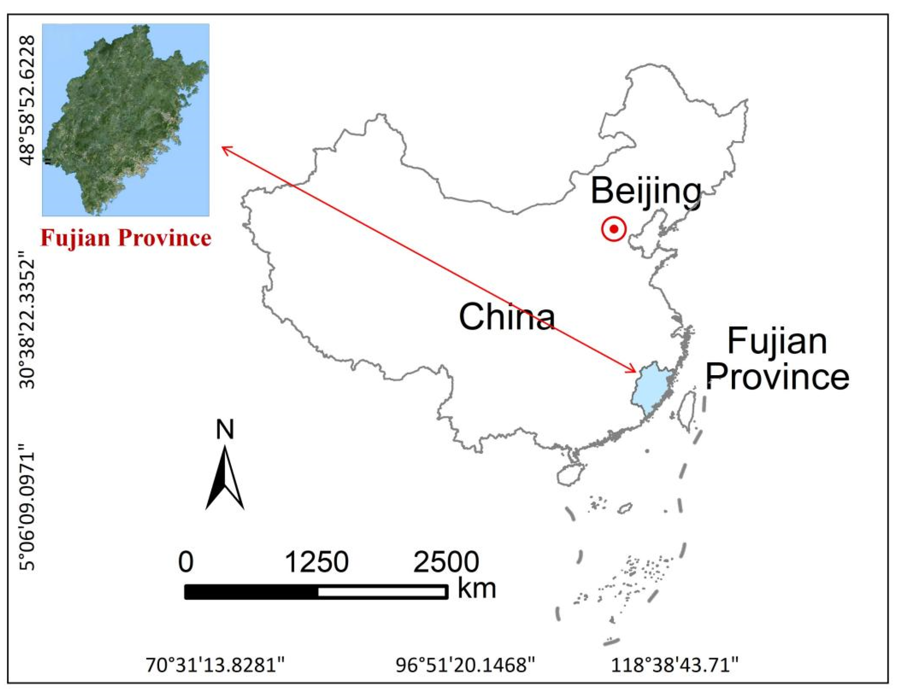
Fujian Province, situated in southeastern China (Figure 1), is predominantly characterized by mountainous and hilly terrain. Influenced by a subtropical monsoon climate, the region experiences abundant and concentrated rainfall, coupled with complex geological conditions, making it highly prone to geological hazards [4]. These hazards often exhibit characteristics such as small scale, strong concealment, and high suddenness, making effective early identification challenging through traditional field surveys and visual remote sensing interpretation, thereby presenting significant difficulties for disaster prevention [5].
In the domain of early geological hazard identification, research has transitioned from traditional field surveys to integrated observation systems that combine ‘space-air-ground’ collaborative monitoring. High-resolution optical remote sensing and unmanned aerial vehicle (UAV) surveys effectively detect potential surface deformations and micro-topographic features, demonstrating particular suitability for hazard detection in vegetated areas and steep slopes [6]. Additionally, Interferometric Synthetic Aperture Radar (InSAR) technology monitors surface deformation, offering dynamic identification and early warning capabilities for slow-moving landslides and ground subsidence [7]. Furthermore, the application of multi-source data fusion and machine learning methods in automatic hazard identification has significantly enhanced both accuracy and efficiency [8].
In susceptibility assessment, research methodologies have evolved from qualitative judgments to integrated evaluations that combine quantitative and intelligent approaches. Traditional methods, such as the Analytical Hierarchy Process (AHP) and information value models, depend on expert experience and historical data, rendering them suitable for small-scale areas or regions with limited information [9]. With the advancements in Geographic Information Systems (GIS) and remote sensing technology, deterministic models (e.g., Infinite Slope Model) and statistical models (e.g., Logistic Regression, Information Value Method) have become prevalent for regional-scale susceptibility mapping [10]. Recently, machine learning algorithms (e.g., Random Forest, Support Vector Machines) have emerged as robust tools for susceptibility assessment, owing to their strong nonlinear processing capabilities and high prediction accuracy. Research indicates that the Random Forest model excels in complex mountainous environments by effectively integrating multi-source environmental parameters and human activity factors, thereby significantly enhancing the reliability and spatial resolution of assessment outcomes [11]. Furthermore, susceptibility assessment is increasingly transitioning from static evaluations to dynamic simulations, including multi-scenario risk predictions under varying rainfall conditions or seismic triggers. This shift offers enhanced scientific support for decision-making in hazard risk management [12].
The Comprehensive Index Method (CIM) serves as a semi-quantitative evaluation approach that establishes a hierarchical indicator system by selecting key evaluation factors. Factor weights are assigned based on expert experience, and a comprehensive risk index is ultimately calculated through weighted summation [13]. This study identified seven evaluation factors, and the risk of artificial cut slopes was assessed based on their corresponding assigned scores and weights. The method’s advantages include the systematic integration of multi-source data, the quantitative representation of complex geological systems, and its strong operability and applicability, particularly for regional-scale risk screening and preliminary assessment [14]. However, existing research predominantly concentrates on regional-scale or natural slope susceptibility assessments, resulting in an underdeveloped specialized risk identification and evaluation system tailored to the specific context of “rural slope-cutting construction” that balances practicality and operability.
Despite the maturity of the comprehensive index method, its systematic application to the high-risk and poorly researched human engineering scenario of rural cut-slope construction remains a crucial and innovative endeavor. Furthermore, climate change is increasingly recognized as a critical driver of landslide activity worldwide [15]. Altered precipitation patterns, particularly the increased frequency and intensity of extreme rainfall events, are significantly modifying slope stability conditions across diverse geological settings [16]. In regions like Fujian Province, which is influenced by a subtropical monsoon climate, the heightened occurrence of typhoons and heavy rainfall episodes amplifies the triggering mechanisms of landslides, especially on slopes already destabilized by human engineering activities such as cut-slope construction [17]. While previous studies have extensively addressed regional landslide susceptibility [18,19], the compounded effects of climate change and specific human activities—particularly unplanned rural cut-slope construction—remain underexplored. Therefore, developing an early identification system that accounts for both intrinsic geotechnical parameters and extrinsic, climate-related triggers is imperative for proactive hazard management and climate adaptation planning.
This study, focusing on Fujian Province, utilizes the CIM to establish an early identification indicator system for assessing geological hazard potential related to rural cut-slope construction (GPU-accelerated computing platform, NVIDIA Corporation, Shanghai, China). Seven key evaluation factors were chosen: slope-wall distance, cut-slope height, cut-slope gradient, natural slope gradient (indicative of rock/soil hardness), soil layer thickness (reflecting structural plane conditions), soil type (representing geometric characteristics), and cut-slope age. Through the integration of diverse geospatial data sources, potential hazard sites were automatically identified, and risk classification was conducted. The framework enabled the identification of hazards, grading of risks, and validation of results on a regional scale (Python, Version 3.11.5). The primary objective of this approach is to establish a scientific foundation for the precise prevention and management of geological disasters and risks in rural mountainous regions.

2. Study Area Setting

2.1. Geological Environment

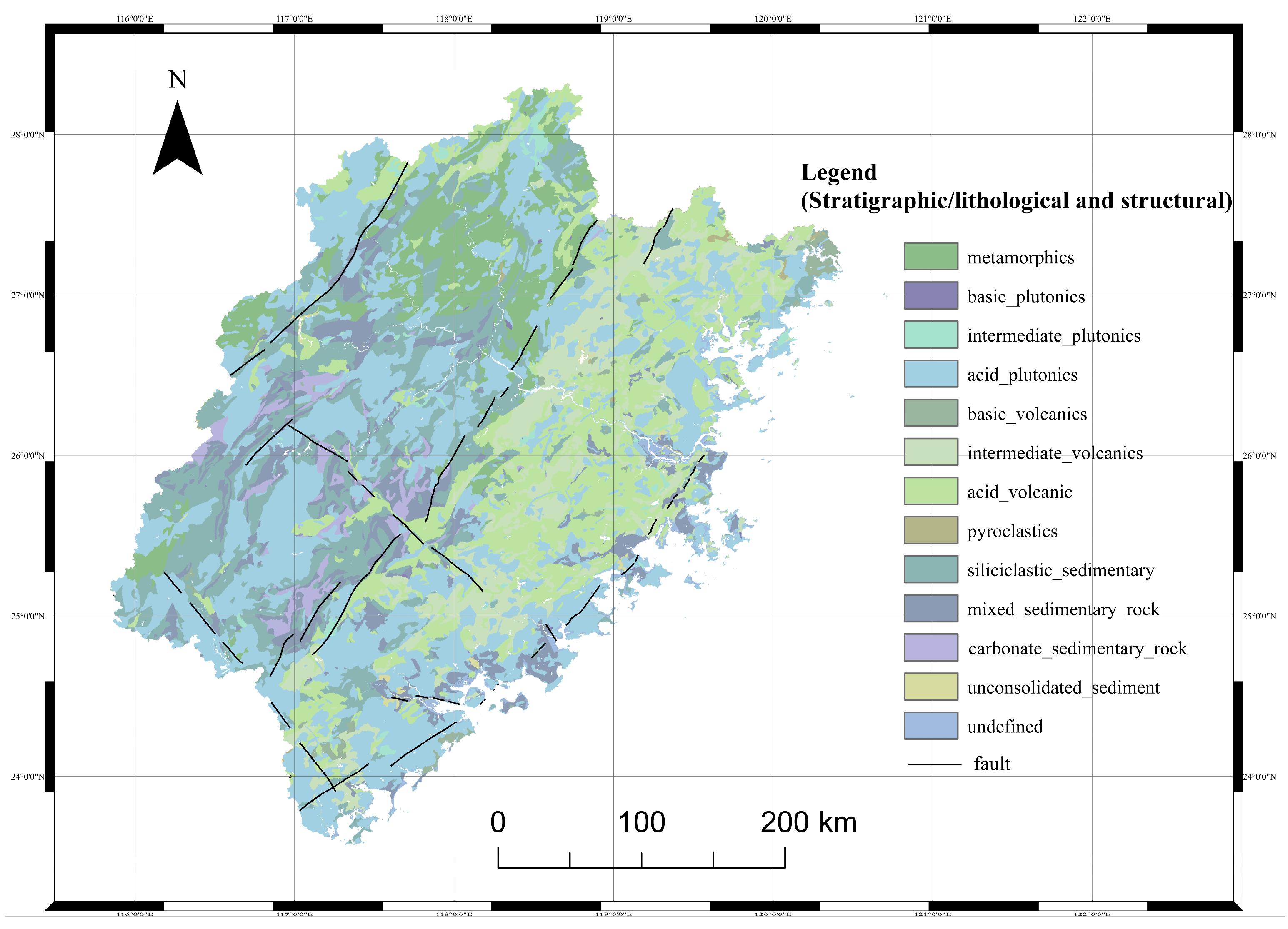
Fujian Province is situated on the southeastern margin of the Eurasian Plate, within the circum-Pacific tectonic-magmatic activity belt. The regional fault system is predominantly oriented in NNE–NEE trends, with additional multi-directional cross-cutting faults, collectively forming a tectonic framework characterized by “east–west zonation and north–south segmentation (Figure 2)”. The rock mass distribution exhibits distinct zoning: the northwestern part is composed of Proterozoic metamorphic rock series; the central to southwestern areas are widely covered by Sinian–Cretaceous weakly metamorphosed rocks and sedimentary-volcanic sequences; while the eastern region is dominated by Late Jurassic–Early Cretaceous thick continental volcanic rock series, with Quaternary unconsolidated sediments only sporadically distributed along the coast (Figure 2).
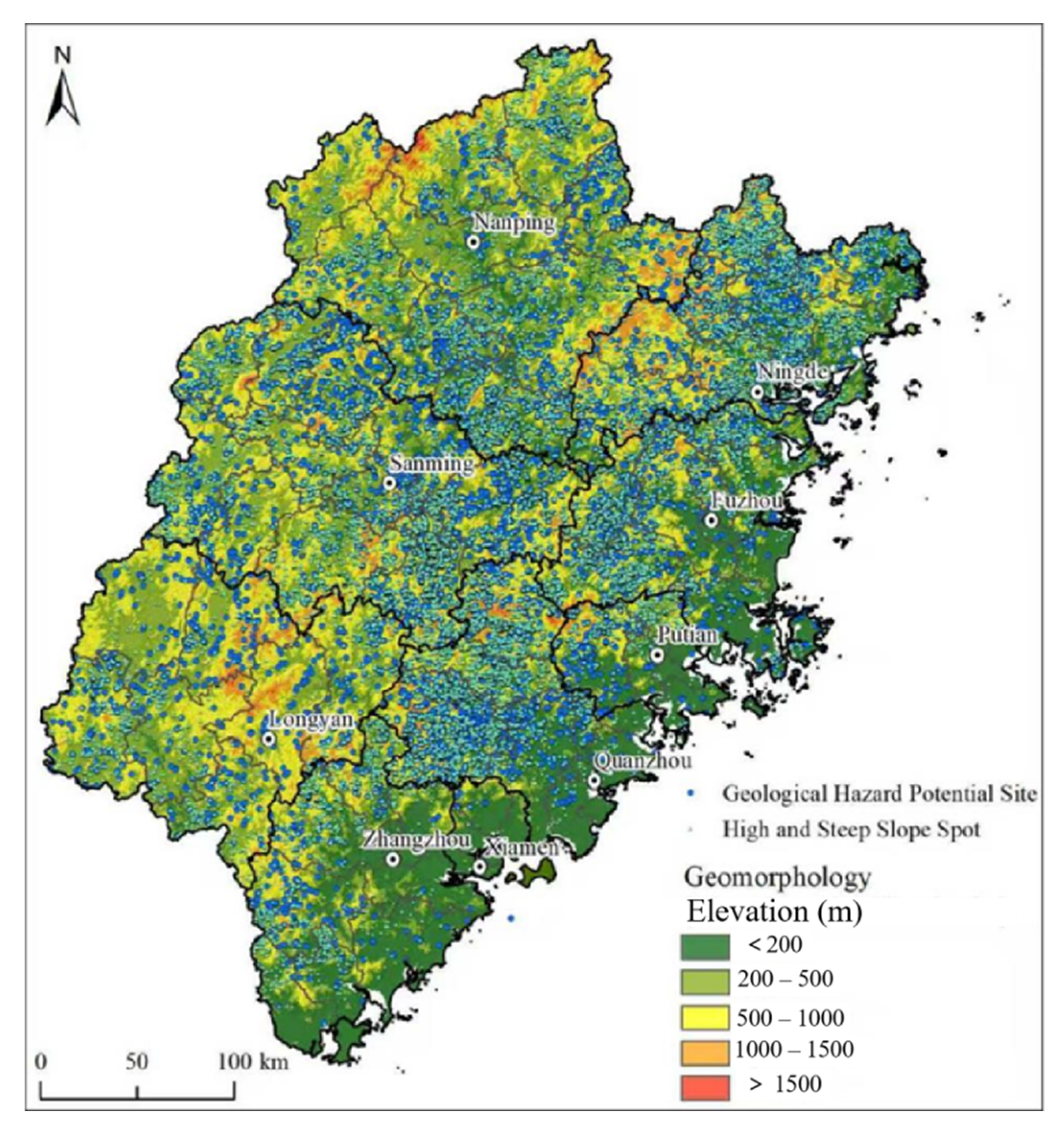
Topographically, the province presents a three-tiered staircase descending from northwest to southeast, where mountains and hills constitute approximately 90% of the land area. The Wuyi Mountains, with their highest peak, Huanggang Mountain, reaching an elevation of 2158 m, form an ecological boundary between Fujian and Jiangxi. Along the southeastern coast, four major plains—Fuzhou, Puxian, Quanzhou, and Zhangzhou—have developed, alongside 1546 islands. The landforms encompass various types, including Danxia, karst, and granitic marine erosion morphologies (Figure 3).
The region experiences a subtropical maritime monsoon climate. Mean annual temperatures range from 17 °C to 21 °C, with total annual accumulated temperatures based on daily mean temperatures ≥ 10 °C ranging from 5000 °C to 7600 °C. Precipitation is abundant and seasonal, with annual rainfall measuring 1400 mm to 2000 mm, 82% of which is concentrated from March to September. The river network density ranks among the highest nationally, and the average annual runoff is approximately 1.2 × 10¹¹ m3, indicating rich hydropower resources. The area is also significantly affected by meteorological-geological hazards such as typhoons, rainstorms, seasonal droughts, and cold waves. The combination of this complex geological setting, steep topography, and rainfall-rich monsoon climate establishes a regional background where slopes are highly susceptible to failure, especially when disturbed by human activities such as cut-slope construction.

2.2. Data Sources and Automated Extraction

This study collected cadastral survey polygon data of rural buildings, the building thematic layer from 1:10,000 Digital Line Graphics (DLG) (ArcMap, version 10.2), 1:10,000 Digital Elevation Models (DEM), and the latest available high-resolution remote sensing imagery (ArcMap, version 10.8.1) (Table 1).
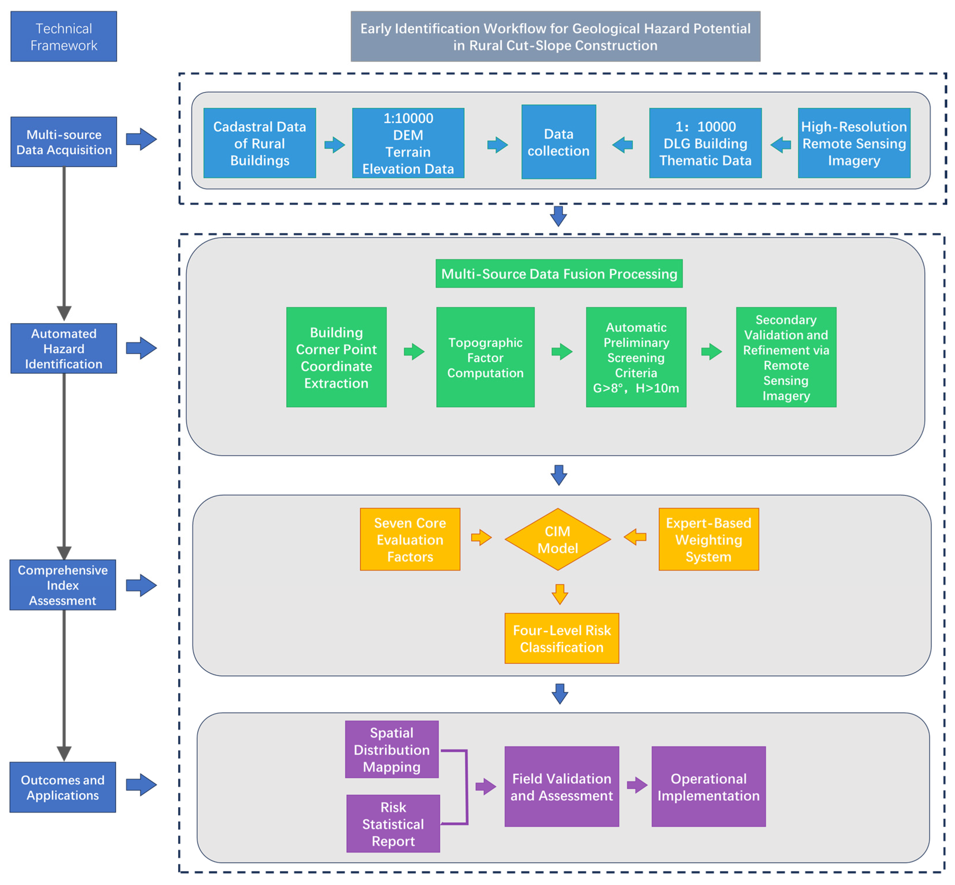
Based on our team’s preliminary investigations, rural cut-slope construction in Fujian Province exhibits the regional characteristics of “over 90% of slope-wall distances ≤ 3 m and cut-slope gradients mostly > 45°”. Therefore, by integrating multi-source geospatial data, the following rules were established for the automated identification and extraction of potential geological hazards induced by cut-slope construction: (1) Using semantic matching and geometric registration techniques, we integrated rural building cadastral survey polygons and 1:10,000 DLG to create a building footprint dataset, and extracted building corner points as evaluation units; (2) Based on a window gradient algorithm and using the 1:10,000 DEM, we computed the slope gradient and neighborhood elevation difference at corner points, and marked hazardous control points that met the criteria; (3) Using “slope > 8° and elevation difference > 10 m” as the judgment criterion, we screened suspected hazard patches containing hazardous corner points based on spatial containment relationships; (4) Combining high-resolution remote sensing imagery for secondary verification, we eliminated false patches and completed refinement and updating. Finally, we distributed the indoor-identified patches to various geological hazard technical support teams for field verification, collected basic cut-slope information from suspected hazard sites, and provided data support for the subsequent indoor evaluation. This technical workflow achieves full automation from data preprocessing to potential hazard identification, demonstrating operational readiness for practical implementation (Figure 4). This automated identification process is particularly crucial for rapidly screening areas vulnerable to climate-triggered hazards, as it efficiently pinpoints slopes where human modification has created a precondition for failure ahead of extreme rainfall events.

3. Hazard Assessment Using the CIM

3.1. Principles of the Comprehensive Index Method

The CIM [20] is a quantitative evaluation approach widely used in geological hazard risk assessment, recognized as one of the most extensively applied and mature quantitative methods in the field. By selecting key influencing factors and converting them into unified standard indicators, this method assigns weights to each indicator based on expert experience or mathematical models and generates a single comprehensive risk value through weighted calculation [21]. It thereby facilitates the index-based representation of complex systems and the classification of regional risk levels, with the index value being positively correlated with the degree of hazard risk, represented by Equation (1):
F i = j = 1 p W i j × S i
where F i is the comprehensive index for the i−th artificial cut slope; W i j is the assigned score of the j-th evaluation factor for the i-th artificial cut slope; S i is the weight of the j-th evaluation factor; p is the total number of evaluation factors, in this study, p = 7; i denotes the serial number of each artificial cut slope; and j represents each evaluation indicator factor, where j = 1, 2, ….
The determination of weights in this study integrated independent scoring from 15 domain experts. Following statistical analysis and consistency testing of their responses, the average values were adopted, thereby ensuring the scientific validity and regional applicability of the weight allocation [22].

3.2. Indexing of Hazard Factors

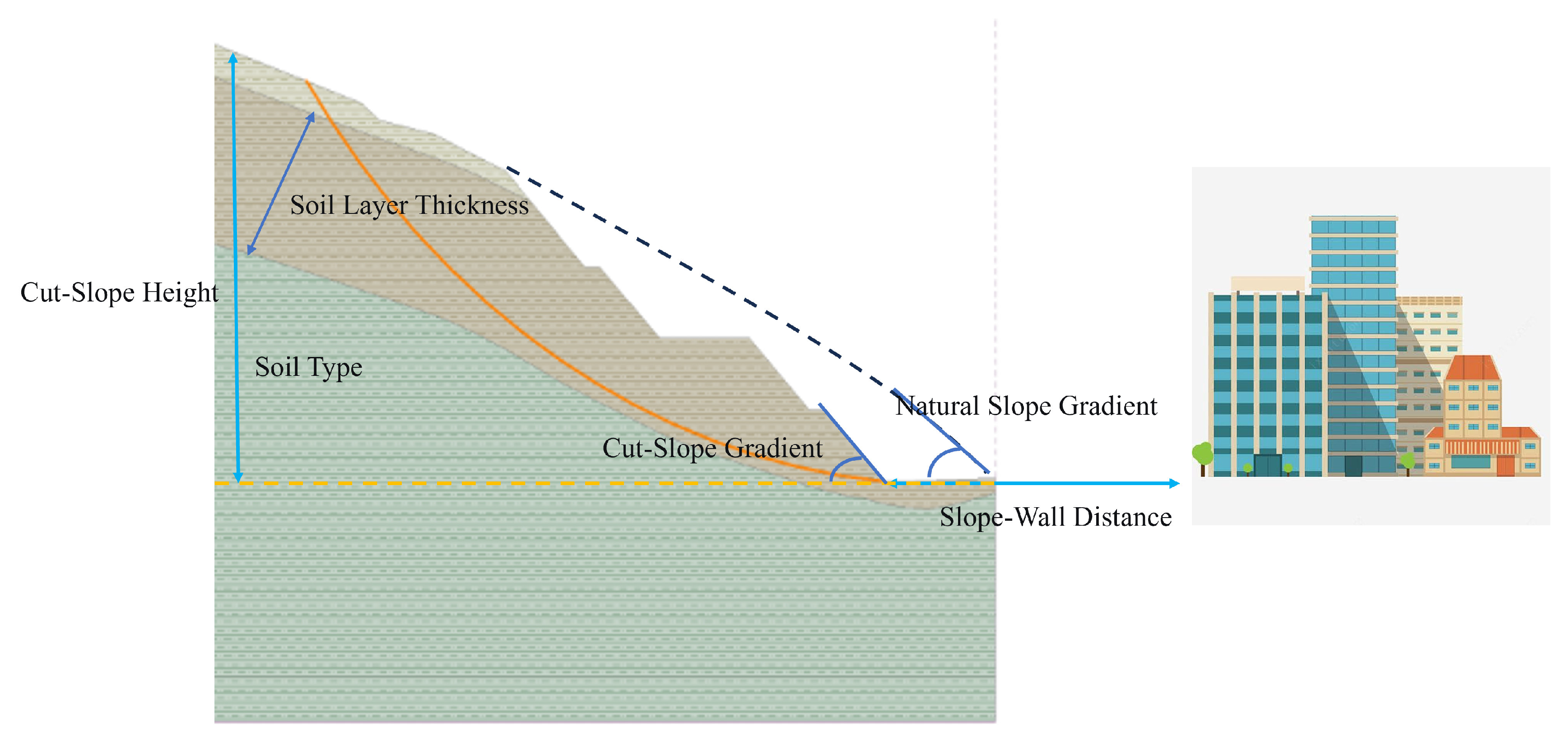
In rural areas of Fujian Province, the material source of landslides and collapses occurring around houses is predominantly soil. Among these, slope stability shows significant correlations with factors such as the physical and mechanical parameters of the soil layer, cut-slope height, and slope gradient [23]; Slope morphology controls the formation process of geological hazards by influencing both gravitational potential energy and water convergence conditions [24], while the physical and mechanical parameters of the soil layer are directly linked to its genesis and type. The slope-wall distance is a direct factor determining whether the hazard body poses a threat to the affected body and the extent of its impact. Simultaneously, after cutting, the slope undergoes a process of stress redistribution, and under external triggering conditions such as rainfall, its local stability will reach a new equilibrium state. In summary, the core indicators for the risk assessment of rural cut-slope construction in Fujian Province are determined as follows: slope-wall distance, cut-slope height, cut-slope gradient, natural slope gradient, soil layer thickness, soil type, and cut-slope age. Among these, the rock hardness classification was determined with reference to the Chinese national Standard for Engineering Classification of Rock Mass (GB/T 50218-2014) [25]. The weights and graded assignments for each evaluation factor are detailed in Table 2 and Figure 5. The selection and weighting of these seven core indicators inherently account for a slope’s susceptibility to climate triggers, particularly heavy rainfall. For instance, the soil type and soil layer thickness directly influence rainfall infiltration capacity and pore-water pressure buildup, while the natural slope gradient and cut-slope gradient control surface runoff and internal drainage paths [26]. Thus, the Comprehensive Index (F) not only reflects static stability but also proxies the dynamic susceptibility to rainfall-induced instability.

3.3. Hazard Classification

Based on an in-depth understanding of the geological hazard characteristics triggered by rural cut-slope construction in Fujian Province, and taking into careful consideration socio-economic levels and disaster prevention and mitigation capacity, the following classification rules are established:
  • For soil slopes, if the following conditions are simultaneously met: H < 5 m, cut-slope gradient > 65°, natural slope gradient > 35°, and slope-wall distance ≤ 2 m, they can be directly classified as medium risk.
  • For rock slopes, when conditions such as dip direction parallel to the slope surface (including apparent dip, bedding plane, or overhanging conditions), mud-filled joints with an aperture > 3 mm, H < 5 m, and slope-wall distance ≤ 2 m are met, they can be directly classified as medium risk.
  • For both rock and soil slopes, if D > 2H/3 and the above conditions are not satisfied, they can be directly classified as low risk.
  • For all other scenarios, the risk level shall be determined according to the following table:
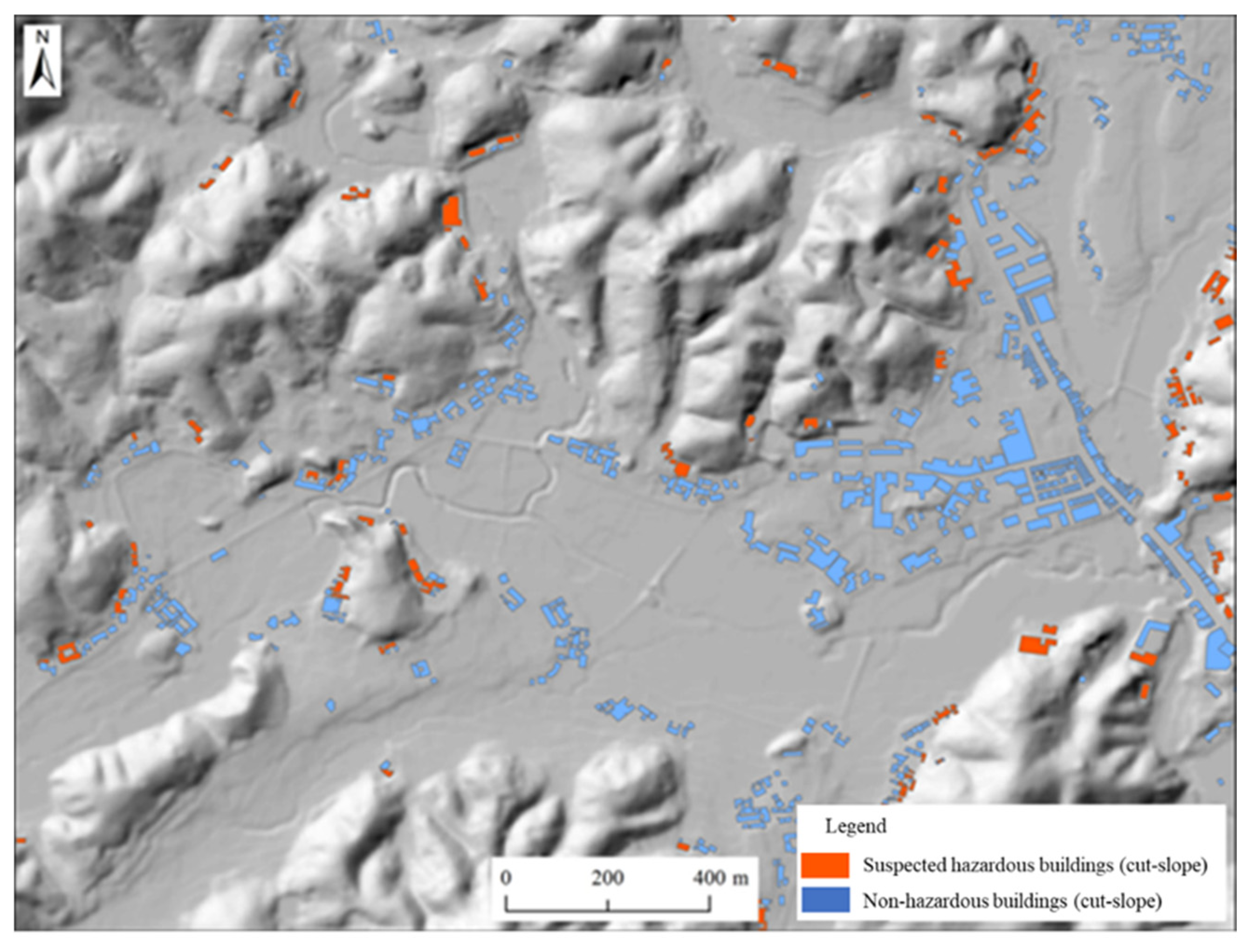
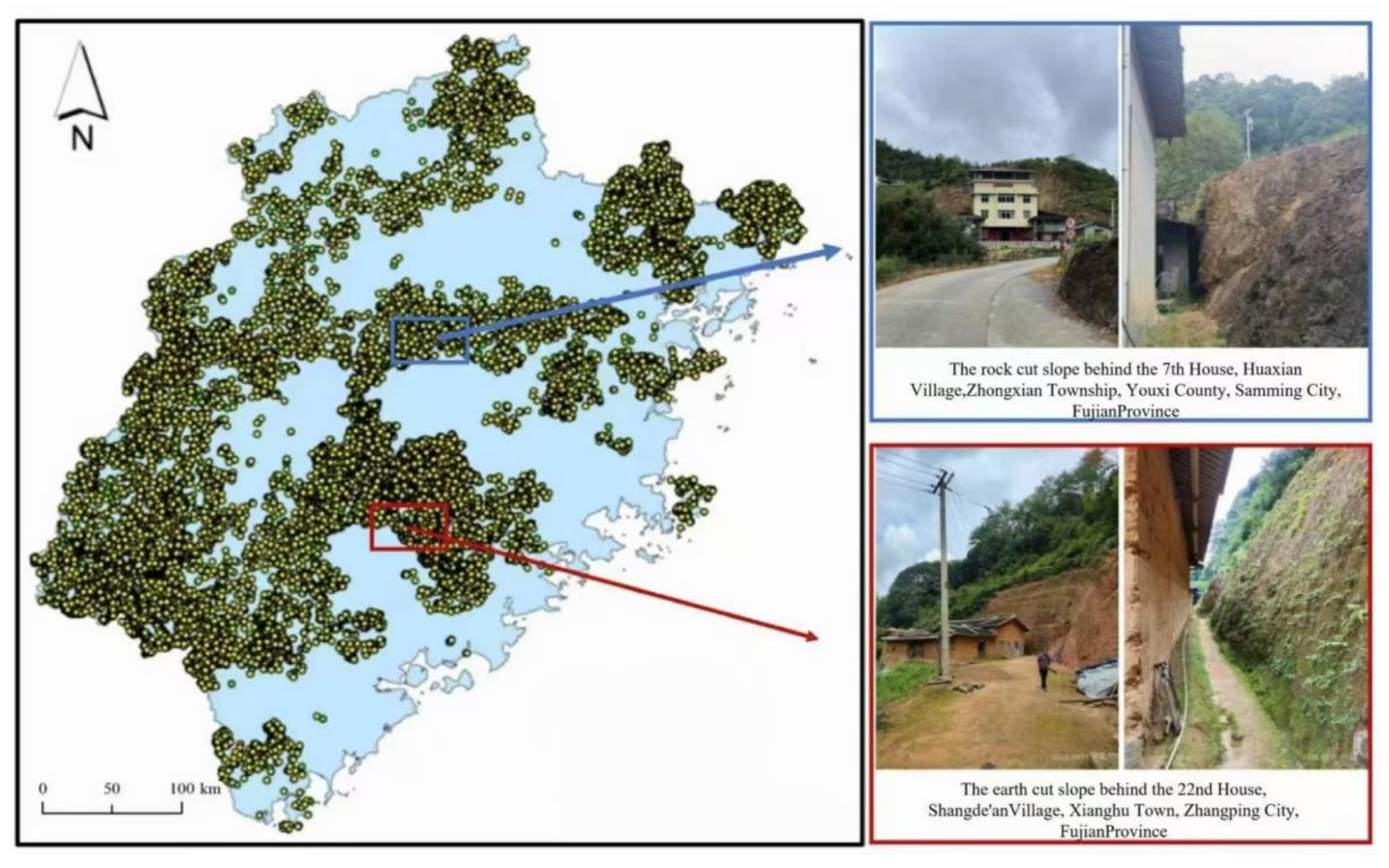
Given the high sensitivity of soil slopes to variations in moisture content and their pronounced residual strength degradation, the initially assigned evaluation grade requires context-dependent adjustment according to the following rules: an upgrade by one level shall be applied in cases of groundwater (or surface water) influence, observed deformation features, or a soil thickness ratio below 20%; a downgrade by one level is warranted for slopes that have remained stable for over 10 years since cutting or those equipped with elementary retaining structures; an upgrade by one level is mandatory for sites with earth/timber or brick/timber structures already classified as medium risk or higher; furthermore, any slope with H ≥ 10 m and a gradient ≥ 75 ° lacking support, initially assessed as low risk, shall be forcibly elevated to medium risk, while all other grades remain unaltered. Representative identified patches of rural cut-slope construction are illustrated in Figure 6.

4. Spatial Distribution of Geological Hazards

4.1. Spatial Distribution by Hazard Level

Based on the spatial distribution patterns of cut-slope construction sites (Figure 7) and statistical data of geological hazard potential sites (Table 3), there exists a strong spatial correlation between cut-slope construction sites and geological hazard potential sites across the province, both exhibiting significant regional heterogeneity. The spatial distribution of cut-slope construction sites demonstrates a pattern of being “significantly denser in inland areas and sparser in coastal regions.” Their distribution closely correlates with topography, concentrating primarily in western and central regions and decreasing progressively from west to east. In the eastern coastal areas, they occur only sporadically in localized low hills and terrains, with high concentrations observed in inland mountainous areas, including Nanping City in northwestern Fujian, Sanming City in central Fujian, and Quanzhou City, the western mountainous areas of Ningde City in northeastern Fujian, and northern Longyan City in western Fujian. In contrast, the eastern coastal plains and low hill platforms along the Fuzhou to Zhangzhou corridor show sparse distribution. Correspondingly, the total number of geological hazard potential sites shows marked spatial variation. The core distribution areas are Quanzhou City (39,541 sites), Sanming City (35,154 sites), and Longyan City (23,726 sites), which collectively account for 67.9% of the provincial total (144,089 sites). This spatial clustering in inland northwestern, central, and western Fujian exhibits a strong correlation with the regional precipitation pattern, where these mountainous areas typically receive higher annual rainfall and are more frequently impacted by the inland penetration of typhoons and stationary fronts [27]. The convergence of high-hazard potential and intense rainfall zones underscores the compound risk under current and projected climate conditions. Xiamen City (452 sites) and the Pingtan Comprehensive Experimental Zone (369 sites) contain the fewest sites, collectively accounting for less than 1% of the provincial total.
Analysis of the geological hazard potential level structure (Table 4) reveals prominent spatial heterogeneity across different risk grades (Very High, High, Medium, Low). Low-risk potential sites constitute the highest proportion across all regions, with Quanzhou City (34,654 sites, 87.6%), Sanming City (28,278 sites, 80.4%), and Longyan City (12,641 sites, 53.3%) ranking highest in proportion. Medium-risk and higher potential sites demonstrate regionally clustered characteristics. The proportions in Xiamen City (47.79%) and Longyan City (46.45%) significantly exceed the provincial average of 21.20%, while Zhangzhou City (10.50%), Putian City (11.41%), and Quanzhou City (12.18%) remain below this average, indicating generally controllable risks in these areas. The distribution of Very High-risk potential sites is relatively dispersed, though core concentration areas remain identifiable. Quanzhou City (19 sites), Sanming City (18 sites), and Longyan City (14 sites) collectively account for 87.1% of the provincial total (70 sites). No Very High-risk potential sites were identified in Xiamen City, Pingtan Comprehensive Experimental Zone, or Putian City, indicating lower upper limits of risk levels in these regions.

4.2. Structural Parameters of Hazardous Slopes

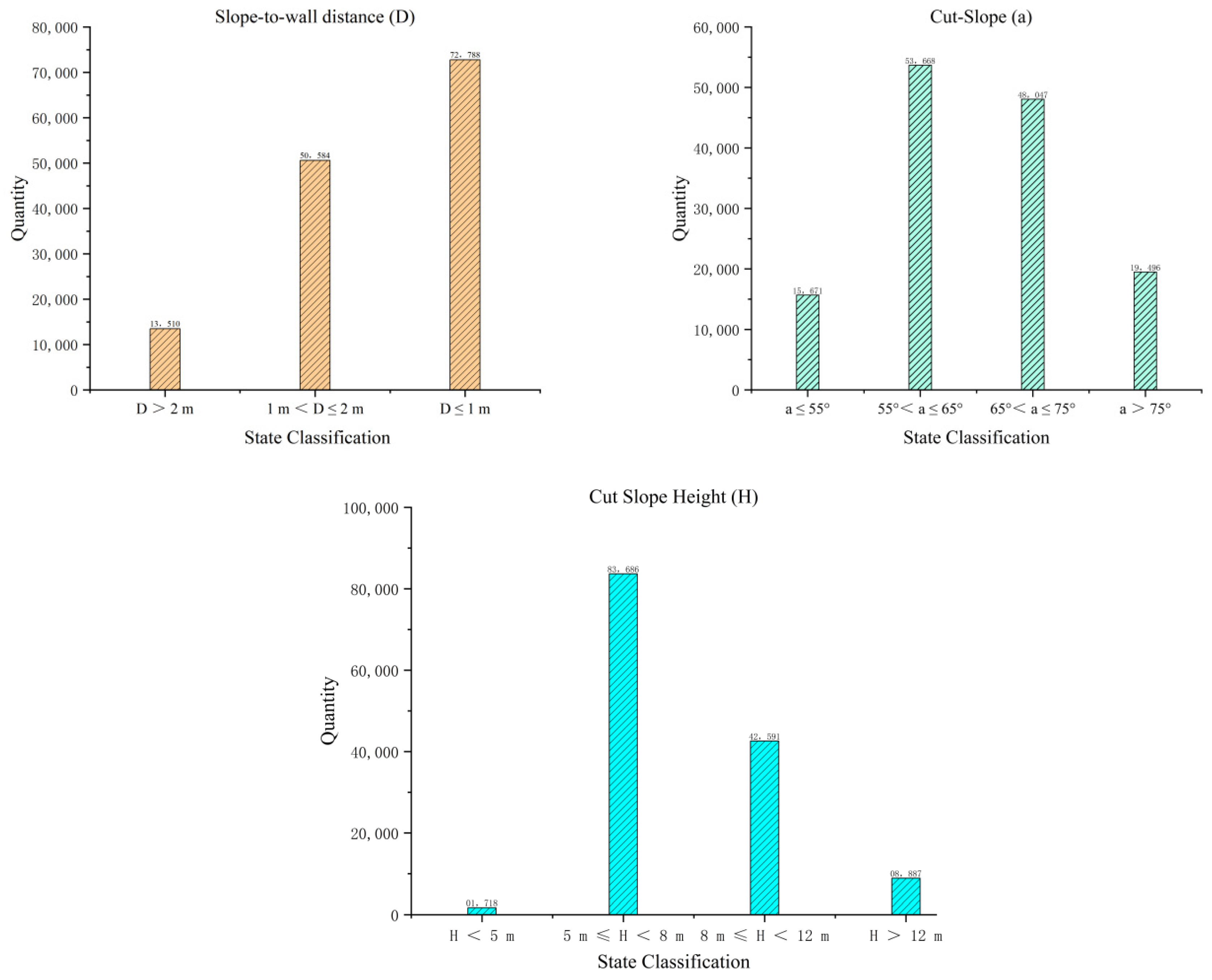
The core structural indicators of potential hazard sites from cut-slope construction demonstrate significant centralized characteristics, with each indicator closely linked to geological hazard risk. Specific analysis reveals that in terms of engineering parameters (Figure 8), a total of 72,788 sites (53.2% of the total) have a slope-to-wall distance of <1 m. Such proximity between structures and slopes makes them highly vulnerable to direct impact during slope deformation; approximately 100,000 sites (74.3% of the total) have cut-slope gradients concentrated within the 55° to 75° range. These steep gradients substantially disrupt the original stress equilibrium of the slope, readily inducing stress redistribution and the development of unloading cracks, thereby creating preconditions for geological hazards. There are 126,277 sites (92.3% of the total) with cut-slope heights falling between 5 m and 8 m. Greater cut-slope heights further elevate the potential risk of slope instability.
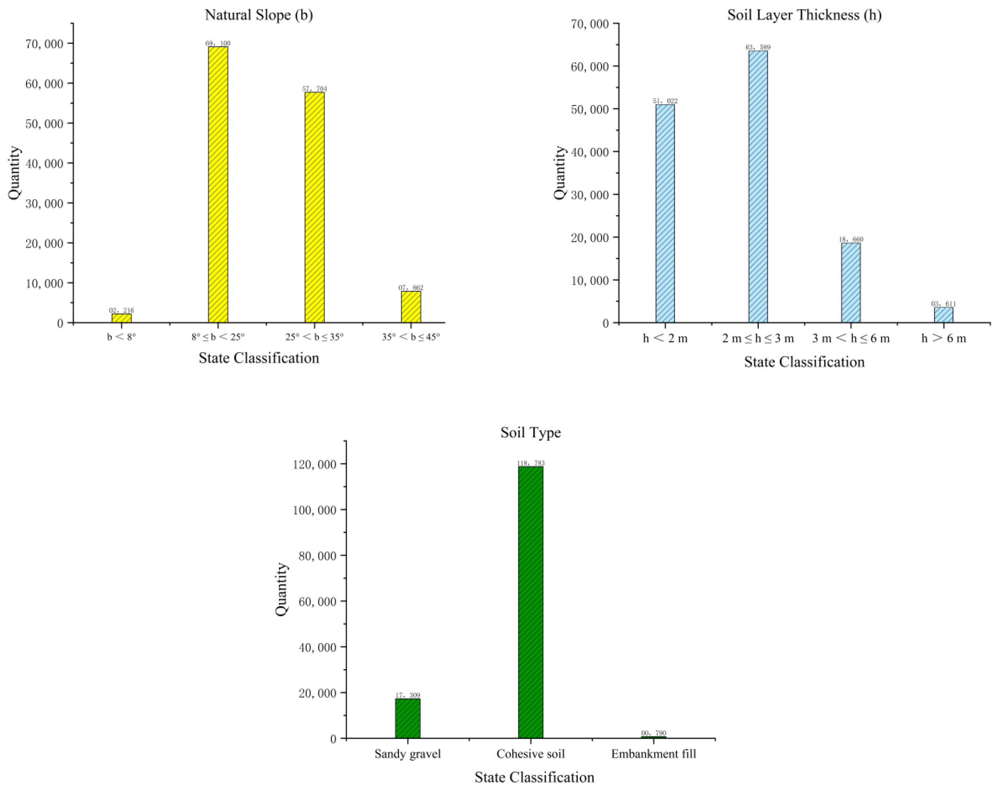
From the dimensions of topography and soil properties (Figure 9), a total of 126804 potential hazard sites (92.6% of the total) are located on natural slopes with gradients between 8° and 35°. Among these, slopes steeper than 25° (accounting for 47.90% of sites in this category) are highly susceptible to failure when triggered by heavy rainfall [28]. Regarding soil type, 118,783 sites (86.8% of the total) are dominated by clay soils. Additionally, 114,611 sites (83.7% of the total) have a soil thickness not exceeding 3 m. Due to the low shear strength of clay soils and the generally shallow soil thickness, the overlying soil layer is prone to sliding along the soil–rock interface under heavy rainfall conditions, resulting in landslide hazards.
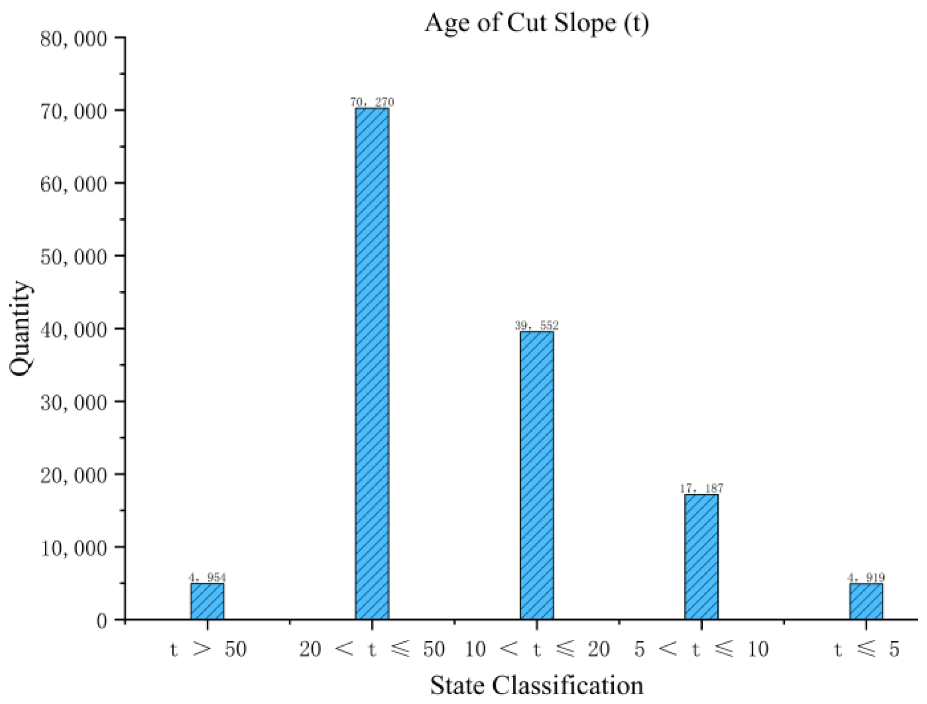
From the temporal service dimension (Figure 10), a total of 109,822 potential hazard sites (80.2% of the total) involve cut-slope structures aged between 20 and 50 years, with only a minority exceeding 50 years of service. Under normal conditions, cut-slope structures within the 20 to 50 years service range commonly face issues such as long-term weathering degradation of geotechnical materials and aging failure of engineering support structures and protective facilities, further reducing overall slope stability. Furthermore, it is noteworthy that many rural artificial slopes lack proper and effective mitigation measures. The first decade following slope cutting represents a primary adjustment period for stress redistribution, during which minor collapses or shallow landslides often occur in the overlying soil layer until a new stress equilibrium is established.

5. Field Validation and Analysis of Results

5.1. Validation of Disaster Events Triggered by Super Typhoon Gaemi (2024) [29]

During the landfall of Super Typhoon “Gaemi” (2024–3) in 2024, multiple areas in Fujian Province experienced heavy rainfall, triggering numerous geological hazard incidents related to rural cut-slope construction. According to post-disaster statistics (Table 5), 49 geological hazard sites associated with rural cut-slope construction were identified within the typhoon-affected area, encompassing various types, including shallow landslides and collapses, and involving several regions such as Dehua County, Sanyuan District, and Yunxiao County. Some sites posed direct threats to nearby rural houses and human safety. Comparative analysis with the potential hazard patches identified in the early stages of this study revealed that 45 out of the 49 hazard sites (91.8%) were located within previously identified potential hazard zones. In Dehua County, multiple hazard events triggered by rear mountain shallow landslides and slope failures behind houses occurred at cut-slope construction sites that had all been identified within the early hazard assessment scope. Furthermore, through advanced issuance of early warnings, these areas achieved zero casualties, fully demonstrating the guiding value of early hazard identification for disaster prevention and mitigation. The calculated Kappa coefficient of 0.85 indicates a high level of agreement between the model identification results and the actual hazard distribution.

5.2. Verification of 9 June Disaster Events in Wuping-Shanghang (2024)

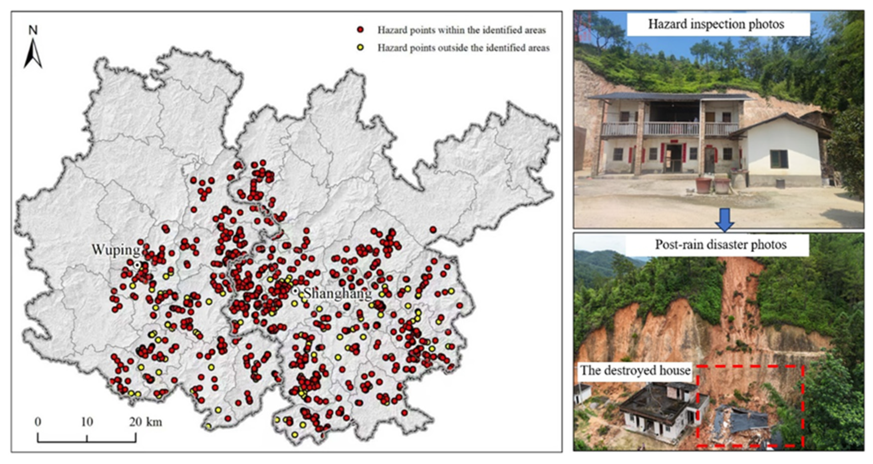
On June 9, 2024, Wuping County and Shanghang County in Fujian Province experienced concentrated occurrences of geological hazards related to rural cut-slope construction triggered by heavy rainfall. According to statistics, this event involved 1019 hazard sites associated with cut-slope construction, primarily characterized by collapses and shallow landslides, widely distributed across rural areas of both counties. Spatial matching and verification between these 1019 hazard sites and the potential hazard patches identified in this study revealed (Figure 11) that 815 hazard sites (79.98%) were located within previously identified potential hazard zones. The calculated Kappa coefficient of 0.72 indicates moderate to substantial agreement between the identification results and actual hazard distribution, further confirming that the potential hazard identification system developed in this study effectively covers high-risk cut-slope construction locations within the region, providing precise spatial guidance for targeted disaster prevention and emergency response efforts.

5.3. Analysis of Validation Results

Based on validation data from two heavy rainfall events, the identification match rate for hazards triggered by Super Typhoon “Gaemi” (2024–3) reached 91.8%, with a Kappa coefficient of 0.85. During the June 9 disaster in Wuping and Shanghang, the match rate approached 80%, with a Kappa coefficient of 0.72. The high match rates and Kappa coefficients fully demonstrate that the early identification indicator system and technical workflow for geological hazard potential in rural cut-slope construction, developed based on the Comprehensive Index Method, exhibit good reliability and applicability. This framework can accurately identify high-risk areas where geological hazards may be triggered by cut-slope construction in rural regions of Fujian Province, thereby providing a scientific and effective decision-making basis for refined geological disaster prevention and control, rural housing safety management, and optimization of territorial spatial planning in the province. The high match rates achieved during these distinct heavy rainfall events confirm that the identification framework effectively captures slopes that are sensitive to climate triggers, specifically short-duration, high-intensity precipitation.

6. Discussion

6.1. Spatial Heterogeneity and the Coupling Mechanism of Geological and Human Activities

This study systematically reveals the distribution patterns and disaster-forming mechanisms of geological hazard potential associated with rural cut-slope construction in Fujian Province by establishing the CIM framework. The findings indicate a distinct spatial heterogeneity of potential hazard sites, characterized as “denser inland and sparser coastal,” which closely aligns with the regional tectonic framework and the intensity of human activities. The development of dominant NNE-NEE trending fault zones in northwestern, central, and western Fujian, combined with the widespread Proterozoic metamorphic rock series and Sinian-Cretaceous weakly metamorphosed rocks, forms a geological background marked by intense tectonic activity and fragmented rock masses [30]. When this fragile geological setting is superimposed with frequent cut-slope construction activities in mountainous areas, it significantly exacerbates geological hazard risks by altering the in situ stress field of slopes and destroying the slope-stabilizing effects of vegetation. This spatial coupling provides clear geographical targeting for regional risk zoning and prevention.

6.2. Structural Parameter Characteristics of Hazard Sites and Geomechanical Mechanisms

Analysis of the structural parameters of potential hazard sites shows that a parameter combination of slope-wall distance ≤ 1 m, cut-slope gradient of 55° to 75°, and cut-slope height of 5 m to 8 m constitutes a typical disaster model. This parameter configuration reflects the practical dilemma of constrained construction land in mountainous areas and inadequate enforcement of engineering standards. The issue of excessively short slope-wall distance is particularly critical, as it places houses directly within the movement range of potential collapse masses, drastically reducing emergency response time. From a geomechanical perspective, cut-slope gradients of 55° to 75° exceed the natural angle of repose of most geomaterials, inevitably leading to stress redistribution. Under conditions where rainfall infiltration softens structural planes, this readily develops into continuous sliding surfaces [31]. These quantified characteristics provide an engineering basis for formulating differentiated prevention and control standards, and it is recommended that slope-wall distance be incorporated as a mandatory indicator in the rural housing construction approval process.

6.3. Methodological Innovation and Application Limitations of the Early Identification Technical System

The early identification technical system established in this study integrates multi-source geospatial data such as cadastral data, DEM, and remote sensing imagery, achieving semi-automated identification of potential hazards [32]. The validation demonstrated match rates exceeding 79.98% and Kappa coefficients above 0.72. Compared to traditional survey methods, this system not only improves work efficiency by approximately 3- to 5-fold but, more importantly, addresses the shortcomings of traditional methods in identifying concealed hazards. During the 2024 Typhoon “Gaemi” disaster, Dehua County, which utilized early warnings based on this model, successfully achieved zero casualties, confirming its practical application value. It is important to note that this method still has limitations, such as dependence on the timeliness of data updates and adaptability to complex geological conditions. The next step involves introducing InSAR deformation monitoring data and machine learning algorithms to build a dynamic risk assessment model.

6.4. Implications Under Climate Change Scenarios

The early identification framework proposed in this study not only provides a tool for current risk assessment but also offers a scalable approach for evaluating landslide susceptibility under future climate scenarios. With the projected increase in extreme rainfall events in Southeast China due to climate change, the triggering frequency of landslides in cut-slope areas is expected to rise [33]. The parameter combination identified in this study—especially the critical role of slope-wall distance, cut-slope gradient, and soil type—can be integrated into dynamic risk models that simulate rainfall infiltration and slope stability under different climate projections [34]. Moreover, the spatial clustering of high-risk sites in inland mountainous regions suggests that these areas should be prioritized in climate adaptation and disaster resilience planning. The method’s ability to integrate multi-source geospatial data also allows for the future incorporation of climate model outputs, InSAR-based deformation monitoring, and real-time rainfall data, enabling a transition from static to dynamic landslide early warning systems [35,36]. Uncertainties in our results arise from three main sources: the smoothing effect of the 1:10,000 DEM on micro-topography and local parameter extraction; positional inaccuracies in cadastral data affecting the precision of “slope-wall distance”; and potential omissions or false positives in the rule-based automated identification despite verification. These limitations indicate that the framework is more suitable for regional risk screening and prioritization, while site-specific assessment requires higher-resolution data or field validation.

7. Conclusions

Using Fujian Province as a case study, this study established an early identification indicator system for landslide hazard potential associated with rural cut-slope construction based on the Comprehensive Index Method, enabling quantitative assessment and risk classification of potential hazard sites. The identification results were validated against actual disaster data from extreme rainfall events. The main conclusions are as follows:
(1)
Geohazards in the region exhibit a distinct “high density inland and low density along the coast” pattern. High-risk sites cluster in the northwestern, central, and western mountains, a distribution attributed to steep terrain, clayey soils, and widespread slope-cutting activities.
(2)
High-risk cut slopes are characterized by a distinctive set of structural parameters: very short slope-wall distance (≤1 m), steep cut-slope gradient (55° to 75°), and moderate cut-slope height (5 m to 8 m). This combination constitutes a failure-prone geotechnical setting that is highly susceptible to rainfall triggering.
(3)
Validation based on two heavy rainfall events in 2024 shows identification match rates of 91.8% and 79.98%, with Kappa coefficients of 0.85 and 0.72, respectively. This confirms the method’s good reliability and regional applicability for rainfall-induced landslides and risk prevention under climate change.
(4)
The study finds that high-risk cut slopes cluster inland, revealing a synergy between human activity and geology. The proposed framework offers a scalable tool for regional risk screening, prevention, and climate adaptation, with potential for integration into dynamic early warning systems.

Author Contributions

Conceptualization, X.T. and W.H.; methodology, X.T. and W.F.; software, Y.Y.; validation, W.F.; investigation, Y.Z., J.W. and W.H.; resources, K.L.; data curation, Y.Y., Y.Z. and J.W.; writing—original draft, X.T.; writing—review and editing, W.F.; visualization, Y.Y.; supervision, K.L.; funding acquisition, W.H. All authors have read and agreed to the published version of the manuscript.

Funding

This work is supported by Research and Development of Monitoring and Early Warning Technologies for Episodic Shallow Landslides in Fujian Province, Guiding Program for Science and Technology of Fujian Province (Project No. 2025Y0046); Opening Fund of Key Laboratory of Geohazard Prevention of Hilly Mountains, Ministry of Natural Resources (Fujian Key Laboratory of Geohazard Prevention) (No. FJKLGH2025K005).

Data Availability Statement

The original contributions presented in this study are included in the article. Further inquiries can be directed to the corresponding author.

Acknowledgments

The authors sincerely express their gratitude to all the geological survey teams in Fujian Province for their invaluable support provided in this study. The field investigation data used to validate the effectiveness of identifying geological hazard potential in rural cut-slope construction form an essential foundation for analyzing such hazards in this paper. These datasets were provided by geological teams across Fujian, who have long been dedicated to conducting field geological surveys and systematic data collection. Their efforts ensured the accuracy, reliability, and representativeness of the datasets, laying a solid groundwork for the research outcomes presented herein. Without their contributions, the in-depth analysis of early identification of geological hazard potential associated with rural cut-slope construction accomplished in this study would not have been possible.

Conflicts of Interest

The authors declare that the research was conducted in the absence of any commercial or financial relationships that could be construed as a potential conflict of interest.

References

  1. Zhang, W.; Liu, S.; Wang, L.; Samui, P.; Chwała, M.; He, Y. Landslide Susceptibility Research Combining Qualitative Analysis and Quantitative Evaluation: A Case Study of Yunyang County in Chongqing, China. Forests 2022, 13, 1055. [Google Scholar] [CrossRef]
  2. Ding, W.; Wang, G.; Yang, Q.; Xu, Y.; Gao, Y.; Chen, X.; Xu, S.; Han, L.; Yang, X. Risk Assessment and Control of Geological Hazards in Towns of Complex Mountainous Areas Based on Remote Sensing and Geological Survey. Water 2023, 15, 3170. [Google Scholar] [CrossRef]
  3. Chen, K.; Bai, F.; Wang, T.; Su, Y.; Wang, B. Geological disaster risk assessment based on remote sensing, GIS, and a multi-strategy improved GWO-optimized Elman neural network. Int. J. Digit. Earth 2025, 18, 2496793. [Google Scholar] [CrossRef]
  4. Lin, J.; Chen, W.; Qi, X.; Hou, H. Risk assessment and its influencing factors analysis of geological hazards in typical mountain environment. J. Clean. Prod. 2021, 309, 127077. [Google Scholar] [CrossRef]
  5. Shao, C.; Liu, Y.; Lan, H.; Li, L.; Liu, S.; Yan, Z.; Li, Y. Spatiotemporal distribution characteristics, causes, and prevention advice of fatal geohazards in Jiangxi Province, China. Sci. Total Environ. 2022, 834, 155337. [Google Scholar] [CrossRef] [PubMed]
  6. Silva-Fragoso, A.; Norini, G.; Nappi, R.; Groppelli, G.; Michetti, A.M. Improving the Accuracy of Digital Terrain Models Using Drone-Based LiDAR for the Morpho-Structural Analysis of Active Calderas: The Case of Ischia Island, Italy. Remote Sens. 2024, 16, 1899. [Google Scholar] [CrossRef]
  7. Zhong, J.; Li, Q.; Zhang, J.; Luo, P.; Zhu, W. Risk Assessment of Geological Landslide Hazards Using D-InSAR and Remote Sensing. Remote Sens. 2024, 16, 345. [Google Scholar] [CrossRef]
  8. Sun, H.; Sheng, L.; Dai, Y.; Li, X.; Rui, Y.; Lu, L. 3D geological modeling of tunnel alignment in the complex mountainous region of Yongshan, China, based on multisource data fusion. Eng. Geol. 2025, 354, 108209. [Google Scholar] [CrossRef]
  9. He, H.; Hu, D.; Sun, Q.; Zhu, L.; Liu, Y. A Landslide Susceptibility Assessment Method Based on GIS Technology and an AHP-Weighted Information Content Method: A Case Study of Southern Anhui, China. ISPRS Int. J. Geo-Inf. 2019, 8, 266. [Google Scholar] [CrossRef]
  10. Cetin, M.; Aksoy, T.; Bilge Ozturk, G.; Cabuk, A. Developing a Model for the Relationship Between Vegetation and Wind Power Using Remote Sensing and Geographic Information Systems Technology. Water Air Soil Pollut. 2022, 233, 450. [Google Scholar] [CrossRef]
  11. Zhou, Y.; Liu, Y.; Wang, D.; Liu, X. Comparison of machine-learning models for predicting short-term building heating load using operational parameters. Energy Build. 2021, 253, 111505. [Google Scholar] [CrossRef]
  12. Li, Z.; Xiang, J.; Zhuo, G.; Zhang, H.; Dai, K.; Shi, X. Dynamic Landslide Susceptibility Assessment in the Yalong River Alpine Gorge Region Integrating InSAR-Derived Deformation Velocity. Remote Sens. 2025, 17, 3210. [Google Scholar] [CrossRef]
  13. Shah, S.A.A.; Zhou, P.; Walasai, G.D.; Mohsin, M. Energy security and environmental sustainability index of South Asian countries: A composite index approach. Ecol. Indic. 2019, 106, 105507. [Google Scholar] [CrossRef]
  14. Cheng, Y.; Gan, Y.; Shi, C.; Huo, A.; Pei, Y.; Song, Y.; Wang, X.; Ahmed, A. A Critical Analysis of Geological Hazard Risk Assessment Including Future Perspectives. Sustainability 2024, 16, 3701. [Google Scholar] [CrossRef]
  15. Crozier, M.J. Deciphering the effect of climate change on landslide activity: A review. Geomorphology 2010, 124, 260–267. [Google Scholar] [CrossRef]
  16. Feng, W.; Bai, H.; Lan, B.; Wu, Y.; Wu, Z.; Yan, L.; Ma, X. Spatial–temporal distribution and failure mechanism of group-occurring landslides in Mibei village, Longchuan County, Guangdong, China. Landslides 2022, 19, 1957–1970. [Google Scholar] [CrossRef]
  17. Li, S.; Feng, W.; Yi, X.; Liu, K.; Guo, C.; Tang, X.; Wu, Z. Clustered shallow landslides triggered by heavy rainfall in May 2022 in Wuping County, Fujian Province, China. Bull. Eng. Geol. Environ. 2025, 84, 257. [Google Scholar] [CrossRef]
  18. Yao, Y.; Lu, Y. Heterogeneous Ensemble Landslide Susceptibility Assessment Method Considering Spatial Heterogeneity. Remote Sens. 2025, 17, 3639. [Google Scholar] [CrossRef]
  19. Li, H.; Liu, Q.; Wang, Z.; Huang, F.; Chen, X.; Hu, H.; Gu, H.; Hu, W.; Zhou, X. Regional landslide susceptibility prediction considering the optimal discretization of environmental factors. Geocarto Int. 2025, 40, 2543487. [Google Scholar] [CrossRef]
  20. Neelawela, U.D.; Selvanathan, E.A.; Wagner, L.D. Global measure of electricity security: A composite index approach. Energy Econ. 2019, 81, 433–453. [Google Scholar] [CrossRef]
  21. Molinos-Senante, M. Comparative energy efficiency of wastewater treatment technologies: A synthetic index approach. Clean Technol. Environ. Policy 2018, 20, 1819–1834. [Google Scholar] [CrossRef]
  22. Thompson, A.; Taylor, B.N. Guide for the Use of the International System of Units (SI); NIST Special Publication 2008 Edition; NIST Research Library: Gaithersburg, MD, USA, 2008. [Google Scholar]
  23. Lin, X.-y.; Zhang, L.-f.; Yang, Z.; Li, P.; Li, T.-l. Inversion analysis of the shear strength parameters for a high loess slope in the limit state. J. Mt. Sci. 2021, 18, 252–264. [Google Scholar] [CrossRef]
  24. Zhang, S.; Shi, W.; Wang, Y.; Liang, F.; Zhang, J.; Wang, X. Numerical evaluation of the deformation and failure mechanisms and movement processes of the Guanling landslide in Guizhou, China. Landslides 2023, 20, 1747–1762. [Google Scholar] [CrossRef]
  25. GB/T 50218-2014; Standard for Engineering Classification of Rock Mass. Standardization Administration of China: Beijing, China, 2014.
  26. Benham, E. Writing with the SI. Weight. Meas. Connect. 2021, 11, J-032. [Google Scholar]
  27. Zhang, W.; Huang, A.; Zhou, Y.; Yang, B.; Fang, D.; Zhang, L.; Wu, Y. Diurnal cycle of precipitation over Fujian Province during the pre-summer rainy season in southern China. Theor. Appl. Climatol. 2017, 130, 993–1006. [Google Scholar] [CrossRef]
  28. Mu, C.; Yu, X.; Zhao, B.; Zhang, D.; Mao, X.; Zhu, J. The Formation Mechanism of Surface Landslide Disasters in the Mining Area under Different Slope Angles. Adv. Civ. Eng. 2021, 2021, 6697790. [Google Scholar] [CrossRef]
  29. Ma, H.; Wang, F.; Fu, Z.; Feng, Y.; You, Q.; Li, S. Characterizing the clustered landslides triggered by extreme rainfall during the 2024 typhoon Gaemi in Zixing City, Hunan Province, China. Landslides 2025, 22, 2311–2329. [Google Scholar] [CrossRef]
  30. Yang, Z.-Y.; Jiang, S.-Y. Detrital zircons in metasedimentary rocks of Mayuan and Mamianshan Group from Cathaysia Block in northwestern Fujian Province, South China: New constraints on their formation ages and paleogeographic implication. Precambrian Res. 2019, 320, 13–30. [Google Scholar] [CrossRef]
  31. Lu, X.; Jiang, Y.; Wang, N.; Shen, H. Progressive deformation and failure mechanism of loess fill slopes induce by rainfall: Insights from flume model tests. Bull. Eng. Geol. Environ. 2023, 82, 385. [Google Scholar] [CrossRef]
  32. Shi, T.; Hu, X.; Guo, L.; Su, F.; Tu, W.; Hu, Z.; Liu, H.; Yang, C.; Wang, J.; Zhang, J.; et al. Digital mapping of zinc in urban topsoil using multisource geospatial data and random forest. Sci. Total Environ. 2021, 792, 148455. [Google Scholar] [CrossRef]
  33. Liu, X.; Wang, Y. Quantifying impacts of precipitation scenarios projected under climate change on annual probability of rainfall-induced landslides at a specific slope. Comput. Geotech. 2024, 167, 106063. [Google Scholar] [CrossRef]
  34. Wu, Z.; Yang, G.; Li, W.; Chen, X.; Liu, F.; Zheng, Y. Numerical Simulation Study of Rainfall-Induced Saturated–Unsaturated Landslide Instability and Failure. Water 2025, 17, 2229. [Google Scholar] [CrossRef]
  35. Su, Y.; Yang, H.; Peng, J.; Liu, Y.; Zhao, B.; Shi, M. A Novel Near-Real-Time GB-InSAR Slope Deformation Monitoring Method. Remote Sens. 2022, 14, 5585. [Google Scholar] [CrossRef]
  36. Huang, Y.; Ma, X.; Li, Q.; Chang, M.; Huang, S.; Lu, L. The deformation characteristics analyses of reactivate water-rich landslide based on DS-InSAR monitoring technology. Nat. Hazards 2025, 121, 20129–20146. [Google Scholar] [CrossRef]
Figure 1. Location of Fujian Province.
Water 18 00460 g001
Figure 2. Geological Map of Fujian Province.
Water 18 00460 g002
Figure 3. Elevation map.
Water 18 00460 g003
Figure 4. Early Identification and Technical Workflow for Geological Hazard Potential in Rural Cut-Slope Construction.
Water 18 00460 g004
Figure 5. Schematic diagram of evaluation factors.
Water 18 00460 g005
Figure 6. Digital Elevation Model (DEM) with representative identified patches of rural cut-slope construction.
Water 18 00460 g006
Figure 7. Distribution of Cut-slope Construction Sites in Fujian Province.
Water 18 00460 g007
Figure 8. Engineering parameters of the cut slopes.
Water 18 00460 g008
Figure 9. Topographic and Soil Property Dimensions of Cut-Slopes.
Water 18 00460 g009
Figure 10. Service Time Dimension of Cut-Slopes (t is the time in years).
Water 18 00460 g010
Figure 11. Distribution of Hazard Sites and Field Photographs from the 9 June 2024 Disaster Events in Wuling and Shanghang.
Water 18 00460 g011
Table 1. Data Sources and Applications in the Study.
DatasetTime PeriodSourceApplication
Rural building cadastral survey polygons2021Natural Resources Real Right Registration Office, Department of Natural Resources of Fujian ProvinceAcquisition of building location, shape, and dimensions
1:10,000 Digital Line Graphs (DLG)2014Fujian Surveying and Mapping InstituteAcquisition of building location, shape, and dimensions
1:10,000 Digital Elevation Model (DEM)2014Fujian Surveying and Mapping InstituteDerivation of surface morphology (e.g., cut-slope gradient, height difference)
High-resolution remote sensing imagery2022Fujian Geologic Surveying and Mapping InstituteSecondary verification
Table 2. Weighting and Graded Scoring of Evaluation Factors for Soil/Rock Slopes.
Soil SlopeRock Slope
No.Evaluation FactorsWeightState ClassificationScoringEvaluation FactorsWeightState ClassificationScoring
1slope-wall distance0.12 m < D1slope-wall distance0.12 m < D1
1 m < D ≤ 2 m31 m < D ≤ 2 m3
D ≤ 1 m5D ≤ 1 m5
2cut-slope gradient0.15a ≤ 55°1cut-slope gradient0.1a ≤ 55°1
55° < a ≤ 65°255° < a ≤ 65°2
65° < a ≤ 75°365° < a ≤ 75°3
> 75°5> 75°5
3cut-slope height0.255 m ≤ H < 8 m1cut-slope height0.25 m ≤ H < 8 m1
8 m ≤ H < 12 m38 m ≤ H < 15 m3
H ≥ 12 m515 m ≤ H5
4natural slope gradient0.25b < 8°1rock hardness degree0.1Hard rock1
8° ≤ b ≤ 25°2Moderately hard rock2
25° < b ≤ 35°3Moderately soft rock4
35° < b ≤ 45°5Soft rock5
> 45°2
5soil layer thickness0.15h < 21Structural plane conditions (strength characteristics)0.2Undulating rough, aperture < 3 mm, cemented1
2 ≤ h ≤ 33
3 < h ≤ 64Planar smooth, aperture < 3 mm, non-cemented3
h > 65Argillaceous fill, aperture > 3 mm5
6soil type0.05Gravel Soil1Bedrock Strata Dip Direction and Topographic Slope Aspect Combination (Geometric Characteristic)0.25Blocky structure slope1
Clay Soil3Adverse dip slope, Subhorizontal bedded slope2
Fill Mass5Oblique slope, transverse slope3
7cut-slope age0.05t > 501cut-slope age0.05t > 501
20 < t ≤ 50220 < t ≤ 502
10 < t ≤ 20310 < t ≤ 203
5 < t ≤ 104t ≤ 105
t ≤ 55
Table 3. Risk Rating.
Comprehensive Index (F)<2.82.8 ≤ F < 3.53.5 ≤ F < 4.0F ≥ 4.0
Risk LevelLowMediumHighVery High
Table 4. Statistics of Geological Hazard Potential Sites by City (District).
City (District)City SitesAssessment GradeProportion Equal to or Greater than MEDIUM Risk (%)
Very High
(Site)
High
(Site)
Medium
(Site)
Low
(Site)
Fuzhou City11,24261011376971013.25
Longyan City23,7261442110,53212,64146.45
Nanping City856871782205617827.89
Ningde City15,8183187265412,97417.98
Pingtan Comprehensive Experimental Zone369007529020.55
Putian City2411040234212811.41
Quanzhou City39,54119576421034,65412.18
Sanming City35,154187425923282,7819.12
Zhangzhou City6808357655609310.50
Xiamen City45201420223647.79
Total144,08970231628,066113,18221.20
Table 5. Disaster Statistics of Super Typhoon Gaemi (2024–03).
County (City)Hazard TypeHouses Damaged
(Unit)
Population at RiskRemarks
Dehua CountyRear Mountain Slope Collapse46All mentioned sites were located within identified hazard zones, and no casualties occurred due to timely warnings. Furthermore, among the 49 hazard incidents recorded during this typhoon event, 45 (91.8%) had been previously identified as potential hazard sites in this study.
10
Side Earth Slide12
Slope Failure Behind House112
Sanyuan DistrictCollapse Behind The House14
Yunxiao County14
28
High-steep Slope Collapse16
Disclaimer/Publisher’s Note: The statements, opinions and data contained in all publications are solely those of the individual author(s) and contributor(s) and not of MDPI and/or the editor(s). MDPI and/or the editor(s) disclaim responsibility for any injury to people or property resulting from any ideas, methods, instructions or products referred to in the content.