Article

Water Scarcity Risk for Paddy Field Development Projects in Pre-Modern Japan: Case Study of the Kinu River Basin


1
Graduate School of Science and Technology, University of Tsukuba, Tsukuba 305-8572, Japan
2
Institute of Life and Environmental Sciences, University of Tsukuba, Tsukuba 305-8572, Japan
3
Institute of Agriculture, Tokyo University of Agriculture and Technology, Fuchu 183-8538, Japan
*
Authors to whom correspondence should be addressed.
Water 2026, 18(2), 179; https://doi.org/10.3390/w18020179
Submission received: 6 November 2025 / Revised: 30 December 2025 / Accepted: 31 December 2025 / Published: 9 January 2026
(This article belongs to the Section Water Use and Scarcity)

Abstract

Japanese modern irrigation management is considered a successful model of water governance worldwide. However, debates continue over whether this success is due to natural water abundance or to water management practices. This study evaluates pre-modern water scarcity risk for six irrigation schemes, developed during that period in the Kinu River Basin (1603–1868); a period without large reservoirs, canal systems, or modern regulatory technologies. As the methodology, pre-modern river flows were reconstructed by removing the effects of four modern dams from the present-day river discharge, adjusting the conveyance efficiency, changes in paddy field area, rainfall input, and return flows. Water demand was assessed using Japanese irrigation standards of 5 mm/d (minimum water demand corresponding to evapotranspiration) and 20 mm/d (easy management), and risk was evaluated under both the prior appropriation and Equal Water Distribution rules. Results show that modern flow in the dry season is approximately 25 m3/s, whereas reconstructed natural flow during drought years declines to 10–18 m3/s, and about 15 m3/s after rainfall adjustment. Under the 20 mm/d demand scenario, scarcity occurred in four schemes (2 of 17 years in the third scheme and 7 of 17 years for the sixth scheme), while no scarcity occurred under the minimum-demand scenario (5 mm/d), even during low-flow conditions. This indicates that the available water in these schemes was at a level where drought damage could occur under extensive irrigation management, but could be avoided by intensive irrigation management to supply the minimum necessary water to all paddy fields.

1. Introduction

Japan’s modern irrigation management has long been regarded as a model of effective water governance. A central pillar of this achievement has been Equitable Water Distribution (EWD), implemented by Water User Associations (WUAs), which has continued since the pre-modern Edo period, ensuring fair allocation and collective maintenance of irrigation systems. This principle allows for maximizing agricultural production within the irrigation scheme [1,2,3].
Following World War II, irrigation infrastructure underwent significant modernization through the construction of multi-purpose reservoirs and canal networks, reinforcing the perception that Japan’s modern irrigation management success was primarily due to its abundant water resources [4,5].
However, this perception is debatable, as many irrigation schemes in Japan continue to follow pre-modern irrigation management practices, and have persisted since the pre-modern period, when large reservoirs, modern canal systems, and regulatory functions did not exist. Was such abundant water truly available even before modern times?
Modern-period reservoirs have secured Japan’s current irrigation situation for one out of ten years of risk at 20 mm/day [6,7]. Compared to other countries, it can be considered that Japan has rich water conditions, that make water management easier.
However, the water available in pre-modern conditions remains unclear and requires clarification. Furthermore, there are no records of damage to rice production despite recurring droughts, and rice productivity has not decreased significantly, even during the most severe droughts [8,9,10,11]. Less available water then suggests that “no damage” results from good irrigation practices. Also, Japan’s current management institutions (WUA) have been developed in the pre-modern era, and the basic system has not changed much. That means the current Japanese management system can be considered including these good practices [12,13,14] and can be helpful to other countries facing water scarcity.
Regarding previous research on water scarcity risk evaluation in pre-modern Japan, certain aspects have been addressed, including historical research on available water, methods for estimating available water, and the effects of climate change on water supply and demand.
Historical research based on documentary records and natural proxies consistently shows that drought was a frequent and structurally embedded feature of pre-modern Japan’s climate, especially during the Edo period. Long-term analyses of climatic hazard chronicles demonstrate recurrent droughts from at least the seventh century onward, occurring across regions and centuries rather than as isolated extremes [15], while reconstructions using administrative documents and local records during the Little Ice Age confirm persistent hydroclimatic stability affecting central and eastern Japan between the seventeenth and nineteenth centuries [16]. High-resolution diary-based studies further reveal repeated clusters of drought years linked to shortened or delayed rainy seasons, a key driver of agricultural water stress in rice-growing basins [17].
Under these conditions of recurring scarcity, community-based irrigation organizations, such as Water User Associations (WUAs), were strongly established and institutionalized. Historical and institutional research shows that irrigation was managed at the village or inter-village levels through collective rules that regulated diversion, rotation, and maintenance under unmanaged river flows [11]. Despite frequent droughts, analyses based on original records suggest that total rice production stayed relatively steady, with no consistent link between droughts and large-scale price spikes, indicating effective local buffering [9]. This stability was maintained through strict drought countermeasures, including rotational irrigation, fair rationing, close canal monitoring, reuse of return flows, and, in extreme cases, sacrificing plots to protect overall production, all rooted in customary law and collective decision-making [3,18,19]. Despite rich historical and institutional insights, current studies are mostly qualitative and lack quantitative assessment. They do not estimate pre-modern river water availability under unregulated conditions.
Regarding the estimation of available water in the pre-modern period, research has advanced through methodological approaches. One approach applies process-based hydrological modeling using reconstructed historical land use and basin characteristics to simulate runoff and discharge in the absence of instrumental observations, allowing past flow regimes to be quantitatively evaluated under historically realistic boundary conditions [20]. Another approach relies on proxy-based reconstructions, particularly dendrohydrological methods, which statistically link tree-ring records to observed discharge to extend river flow series back several centuries and reveal long-term variability not captured by short instrumental records [21]. Also, the approach based on paleo flood hydrology, which integrates geomorphic, sedimentary, and documentary evidence to infer discharge magnitudes beyond the gauged period using hydraulic reconstruction techniques [22]. Despite these advances, pre-modern Japan still lacks integrated reconstructions that translate proxy- or climate-based discharge estimates into irrigation-season effective available water, explicitly accounting for paddy water demand, rainfall contributions, conveyance losses, return flows, and institutional allocation rules, thereby limiting the direct evaluation of historical irrigation water scarcity.
Recent research treats Japan’s water-supply history as a long, connected story from the pre-modern period to the present, focusing on how rainfall and river flow have changed over time. For the pre-modern era, studies using diaries and historical chronicles have converted written weather descriptions into numerical climate indices and combined them with tree-ring isotope records to reconstruct seasonal rainfall, droughts, and prolonged wet periods since the seventeenth century [23,24,25]. These reconstructions show that pre-modern Japan often experienced both droughts and heavy rainfall, with rivers mostly unregulated. In the modern period, researchers use climate model simulations and hydrological models to estimate how climate change alters rainfall patterns, river discharge, and water-supply reliability, especially in large basins such as the Tone River, which supports cities and agriculture [26]. Together, these studies link past climate variability with present-day water problems by linking reconstructed rainfall to modeled river flows. However, most research still does not account for canal losses, return flows, and water-sharing rules to estimate the amount of usable irrigation water in pre-modern times, leaving a gap between climate reconstructions and actual agricultural water availability.
Regarding the effects of climate change on water demand, studies demonstrate that climate changes increase irrigation water demand in paddy systems primarily through enhanced evapotranspiration rather than reduced rainfall. Multi-model and scenario-based studies consistently show that rising temperature, vapor-pressure deficit, and radiation elevate reference evapotranspiration (ETo), thereby increasing rice evapotranspiration (ETc) and seasonal irrigation requirements. Basin- and district-scale analyses further indicate that these climate-driven increases in ETc raise diversion and storage needs, and intensify drought risk in irrigated lowlands [27]. Long-term empirical studies in Japan confirm that paddy ET typically averages 3–4 mm/day, with summer peaks approaching 4–5 mm/day [28], consistent with standard evapotranspiration thresholds used in irrigation engineering and historical analyses [29]. However, few studies jointly reconstruct pre-modern water availability and ET-constrained irrigation demand, leaving the question of how Edo-period irrigation systems balanced limited natural flows against historical evapotranspiration requirements unresolved.
Climate change affects water resources through interacting physical drivers such as temperature rise, precipitation change, increased evaporative demand, and more frequent droughts, which together determine irrigation water availability and risk [30]. Future impacts are typically assessed using coupled climate–hydrological models based on CMIP6 scenarios and downscaled projections [31]. In contrast, past hydroclimatic conditions can be reconstructed using documentary records, natural proxies, and climate-field reconstruction methods; in Japan, historical documents and proxy data reveal frequent droughts and hydroclimatic stress during the Edo period [32]. Although both future and past approaches successfully reconstruct key climate components, few studies quantitatively translate reconstructed pre-modern climate variability into estimates of available river water for irrigation, limiting comparisons between historical irrigation resilience and projected climate-induced water scarcity.
This study evaluates the pre-modern water scarcity risks faced by six irrigation schemes by reconstructing pre-modern river flow and comparing it with the irrigation demand in the Kinu River Basin. It identifies the frequency of shortages and, from the findings, discusses the management practices that would have enabled communities to avoid damage to rice production and sustain reliable yields under highly variable natural hydrology. The findings provide practical guidance (water management practices) for today’s irrigation schemes, especially those with limited storage capacity or highly variable flows.

2. Materials and Methods

2.1. Study Area: Location and Characteristics

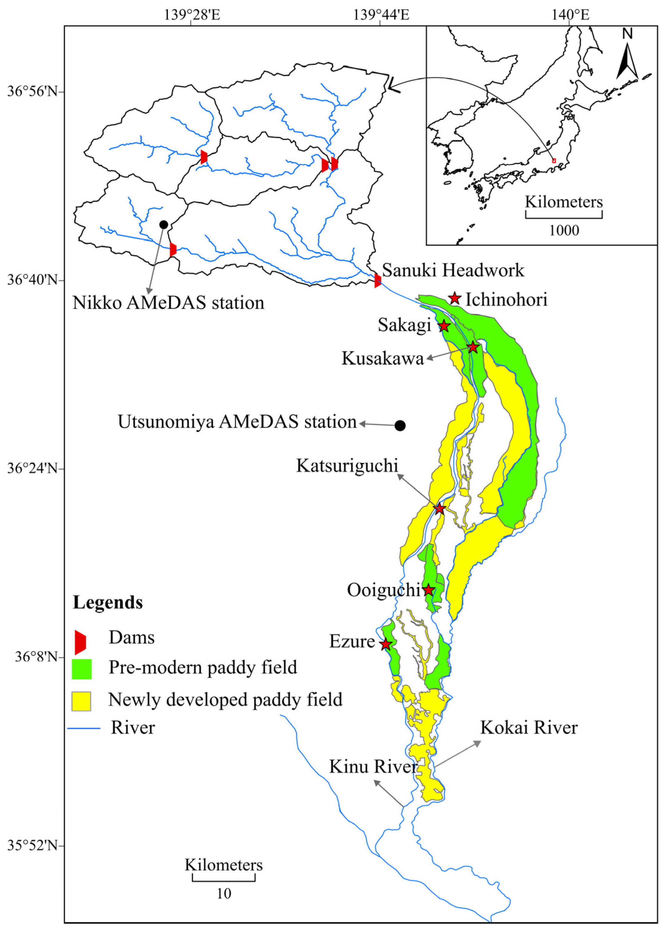
The Kinu River Basin in eastern Japan was selected as the research area, encompassing the plains and uplands of Tochigi and Ibaraki prefectures (Figure 1). The basin provides a unique context for assessing water scarcity risk in pre-modern Japan. Its physical and historical characteristics make it an ideal case for reconstructing hydrological conditions during the pre-modern (Edo period 1603–1868). Six large irrigation schemes, each exceeding 500 hectares, were constructed between 1617 and 1868 (Table 1). Remarkably, all six irrigation schemes remain operational today, allowing modern data to serve as a proxy for pre-modern hydrological conditions.

2.1.1. Physical Characteristics Relevant to Water Scarcity Assessment

Several features make this basin particularly suitable for such analysis. First, the irrigation systems rely exclusively on direct river diversion, without small reservoirs. Second, the mountainous upper catchment (about 1050 km2) produces high seasonal discharge, making mid-summer low flows especially critical for irrigation. Since pre-modern irrigation relied solely on unregulated flow at the Sanuki headworks, it is possible to reconstruct natural water availability by removing the effects of modern dam regulation from MLIT River discharge data. Third, the basin’s hydrological feature is its return flow: a portion of water diverted to paddy fields flows back into the river through surface drainage. This allows both supply and reuse to be quantified within one analytical framework. Detailed hydrological records, including river discharge, rainfall, dam operations, and headworks documentation, are available from the Ministry of Land, Infrastructure, Transport and Tourism (MLIT), AMeDAS official website, and scheme-level Land Improvement Districts (LIDs) offices through interviews. The water allocation system, combined with comprehensive data availability, enables robust reconstruction of the water balance and assessment of scarcity risk during the Edo period.

2.1.2. Historical Characteristics Relevant to Water Scarcity Assessment

Historically, the Kinu River frequently merged with the Kokai River during floods, creating unstable floodplains. Beginning in the early seventeenth century, the Tokugawa shogunate’s flood-control projects physically separated the two rivers, reclaiming fertile land for cultivation. The Kinu River supplies the surface water that sustained both pre-modern and modern irrigation development. This combination of historical continuity and present-day measurability allows for controlled comparisons between natural flow conditions and modern regulated flows.
The current paddy fields along the Kinugawa River are supplied with water from four upstream dams to compensate for water shortages. They also receive irrigation water from three intake weirs constructed during the national agricultural water management project of the 1970s. Towards the end of the 2000s, four dams regulated water availability in the Kinu River watershed. These dams provide non-specified flows that supply irrigation schemes established before their construction. This means that, before their construction, river flow alone could not meet the 1-in-10-year risk reliability standard commonly applied to irrigation water supply in Japan [33,34,35]. This indicates that the Kinu River Basin faced significant water scarcity risks during the pre-modern era, despite the expansion and persistence of irrigation schemes.

2.2. Method

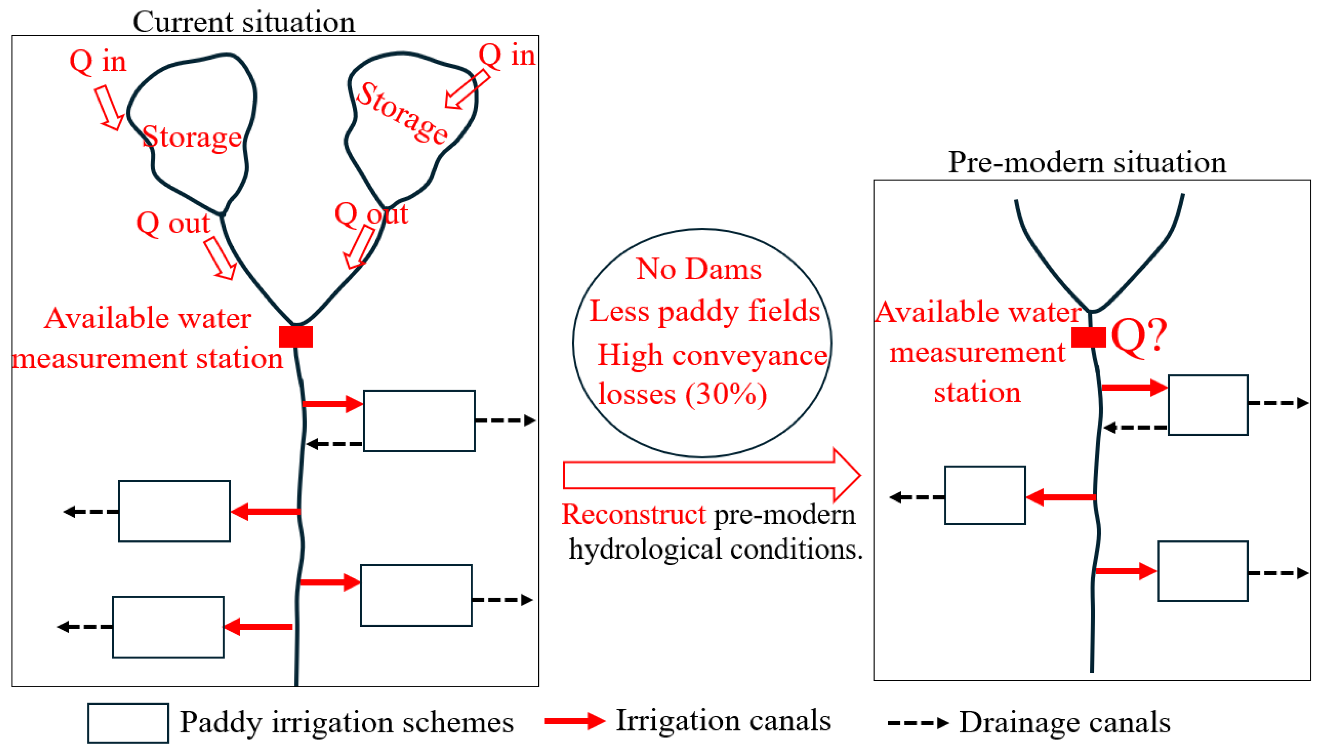
This study assesses the risk of water scarcity in the pre-modern Kinu River Basin by reconstructing natural river flow and comparing it with the water demands of large paddy irrigation schemes. Unlike approaches that integrate climate reconstructions, this research focuses on how changes in irrigation infrastructures from simple diversion systems in the pre-modern period (1603–1868) to modern, regulated networks (dams, headworks, and advanced canal systems) have altered water availability. The influence of irrigation infrastructure is isolated by removing the effects of modern dams, canal efficiencies, and diversion practices (Figure 2).
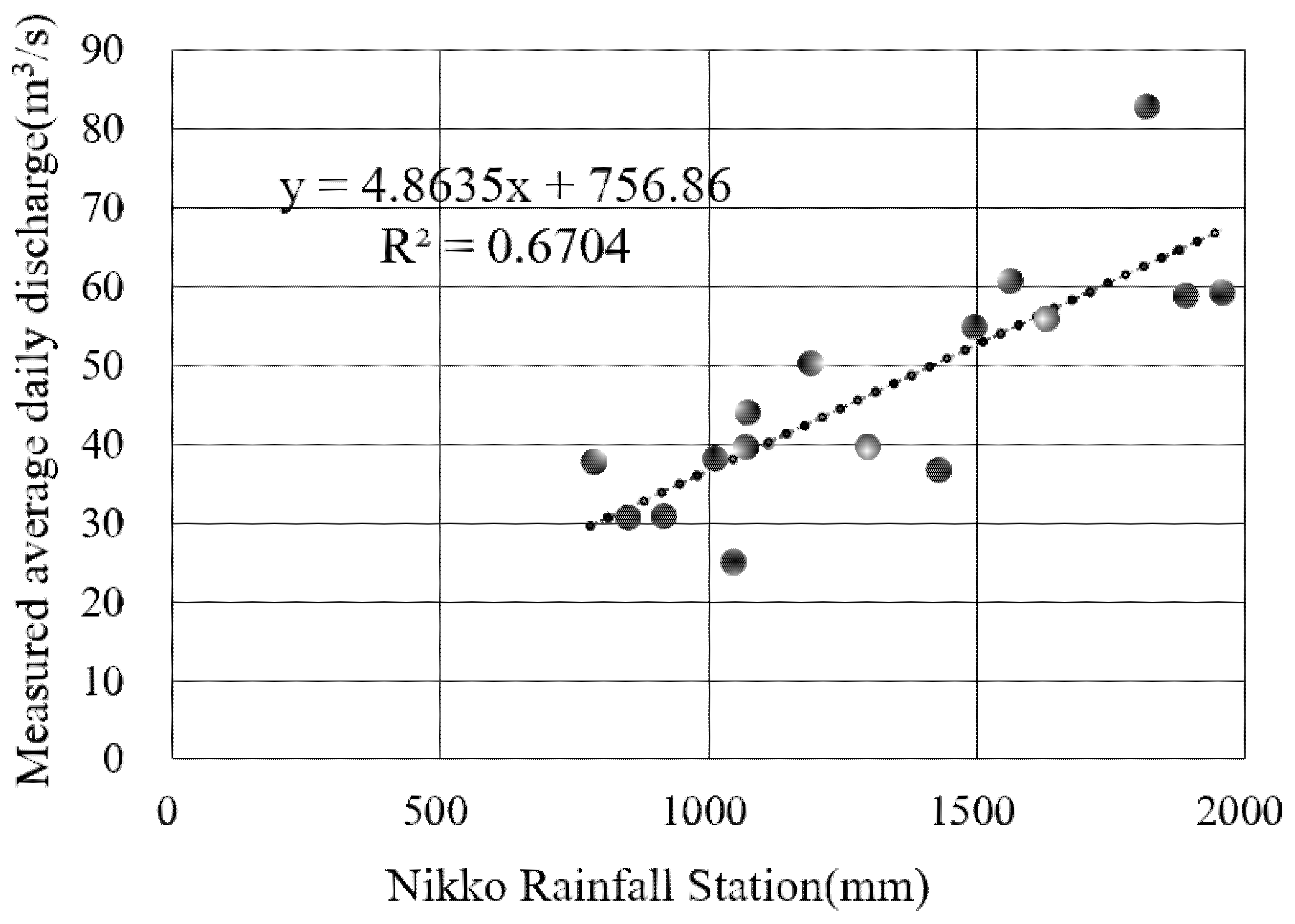
Pre-modern water availability was reconstructed by combining MLIT river discharge records with AMeDAS rainfall from Nikko and Utsunomiya. Present-day discharge at the Sanuki headwork was used as the baseline for reconstructing natural flows. Dams’ influences were removed using inflow–outflow logs to approximate natural flows, while rainfall was added directly to the irrigation supply. To ensure the reliability of the hydrological dataset used in this study, a verification test was conducted comparing rainfall records from the Nikko meteorological station with the estimated natural flow at the Sanuki gauging station. The correlation analysis yielded a coefficient of approximately R = 0.8, indicating a statistically significant positive relationship between the rainfall at Nikko measurement station and the flow conditions at Sanuki headwork. This level of correlation con firms that precipitation patterns captured at Nikko equally reflect hydrological inputs influencing the Sanuki flow regime, thereby validating the reliability of both datasets for subsequent water balance and water scarcity risk analysis (Figure 3).
Key limitations concern MLIT water discharge, including incomplete dam-operation records, rainfall measurement stations, assumptions about long-term rainfall, and reliance on empirical coefficients for conveyance losses and return flows. Despite these constraints, the continuity of diversion points and the basin’s simple diversion hydrology make the dataset suitable for assessing pre-modern scarcity risk.
The analysis approximates the natural flow conditions under which the pre-modern irrigation systems operated. The reconstructed natural flows are then matched against the water demand standards in Japan to assess whether scarcity would have emerged under a pre-modern irrigation system. The objective is to determine whether irrigation schemes established between 1617 and 1868 were designed and managed to minimize the risk of water shortages under natural flow conditions.
Pre-modern canal conveyance losses averaged 30%, consistent with the widely reported loss for unlined earth canals in Japan and comparable systems such as Uganda’s Doho Irrigation Scheme in Africa; modern canal losses were set at 15% [36,37,38]. Due to the absence of reservoirs in the pre-modern period, rice transplanting started in June, with high scarcity risks in July and August, during the flowering and maturation phases [9]. The minimum water demand corresponding to evapotranspiration for rice growth was 5 mm/day, and 20 mm/day for easier water management. Rainfall was added directly to available river water, and 10 consecutive days with less than 5 mm/d were considered to cause damage to rice [39]. To capture deficits and fluctuations critical for yield, a 10-day moving average of combined rainfall and river flow was applied, following national agricultural water studies of Japan.
Irrigation return flow from paddy fields does not return to the river immediately after water is applied; instead, there is a characteristic time lag of several hours to more than a day, depending on soil percolation, field saturation, and drainage ditch storage. This delayed return flow significantly stabilizes downstream water availability during low-flow periods, because water applied in the morning may only reappear in the river by late afternoon or the following day [40]. To approximate natural flow at Sanuki head work, the analysis removed dam storage effects using the relation shown in Equation (1), where Q N F represents natural flow, and Q R F represents return flow; Q i n and Q o u t , respectively, represent the dams’ inflow and outflow. The reconstructed natural flow Q N F was calculated as
Q N F = Q S a n u k i Q o u t + Q i n
where   Q N F : reconstructed natural river flow; Q S a n u k i : observed discharge at Sanuki under regulated modern conditions; Q o u t : combined outflow from the Ikari, Chuzenji, Kawamata, and Kawaji dams; and Q i n : combined inflow entering these dams.
Return flow from irrigated fields to the river system was estimated using a simplified daily water balance equation.
Q R F = Q a p p l i e d A × 5   mm / d
where Q R F : return flow from irrigated land; Q a p p l i e d : water delivered to the irrigation scheme; and A: irrigated area (ha); 5 mm day/d: minimum water demand (evapotranspiration).

2.3. Materials

The materials used were hydrological data from the Ministry of Land, Infrastructure, Transport, and Tourism (MLIT) for 17 years, from 1952 to 1996 (1952–1958, 1960–1963, 1984, 1987–1990, and 1996) [41]. These records include daily inflow and outflow measurements for the Ikari, Chūzenji, Kawamata, and Kawaji dams and were used to adjust for modern storage impacts. Rainfall data obtained from the Nikko and Utsunomiya AMEDAS stations were used, respectively, to validate the reliability of the catchment river flow and to add supplemental water to the paddy field area, since precipitation contributes directly to paddies’ water regardless of canal capacity [42]. Land Improvement Districts (LIDs) have provided information about command areas, intake locations, and infrastructure characteristics. Supplementary information on irrigated areas, intake locations, canal networks, and historical infrastructure was obtained from Land Improvement Districts (LIDs) and through site visits and interviews.
Field surveys were conducted in 2024, complemented by interviews to confirm land-use patterns and pre-modern water management practices.

3. Results

3.1. Recreation of the Modern Water Resources and Waterway Systems

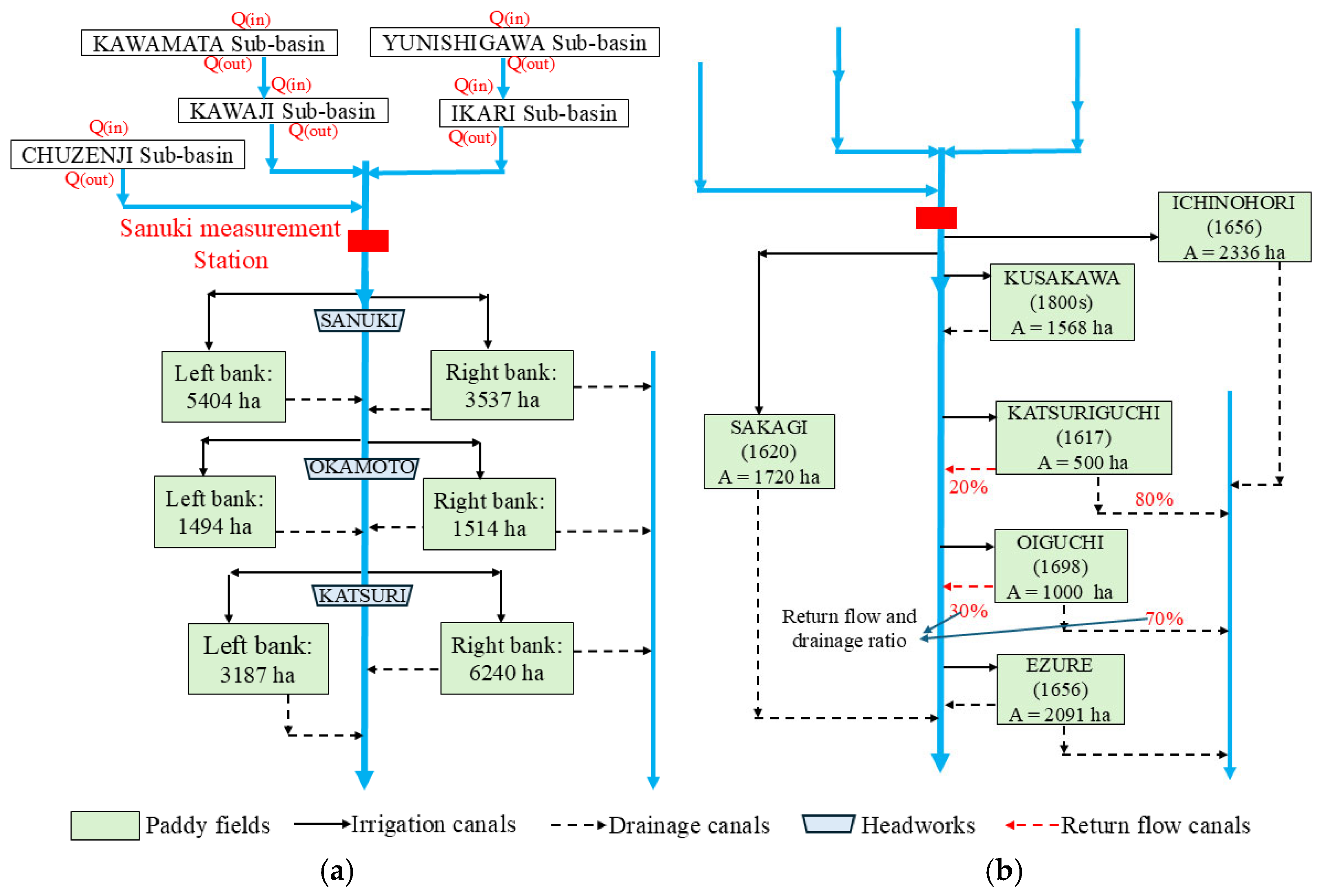
Figure 4a shows the current irrigation system for these paddy field areas based on the project’s planning map. Using this figure as a base, the locations of the six irrigation schemes shown in Table 1 were identified on a map. Figure 4b was then developed by integrating multiple sources: the Kanto Regional Agricultural Administration Bureau’s irrigation district map and 1:50,000 topographic maps, interviews with the Land Improvement Districts, and field surveys, which confirm the drainage points for each irrigation scheme. These sources enabled the precise identification of water intake and drainage, verification of irrigation schemes’ boundaries and their hydrological connectivity, and estimation of drainage ratios. Historical irrigation schemes have undergone minor boundary changes and drainage channels, which are sometimes unclear on maps. Field observations and interviews were essential for validation. For Katsuriguchi and Ooiguchi, where drainage outlets are divided into two branches, drainage ratios were calculated based on the watershed areas draining to each outlet within the scheme. This analysis revealed that pre-modern large paddy field irrigation schemes covered around 9215 ha, compared with present-day areas (around 21,000 ha) in Figure 4a. When assessing whether the pre-modern water supply was sufficient for each irrigation scheme, these conditions must be considered alongside the absence of dams.

3.2. Reconstruction of Pre-Modern Natural Flow, Using the River Flow in 1996

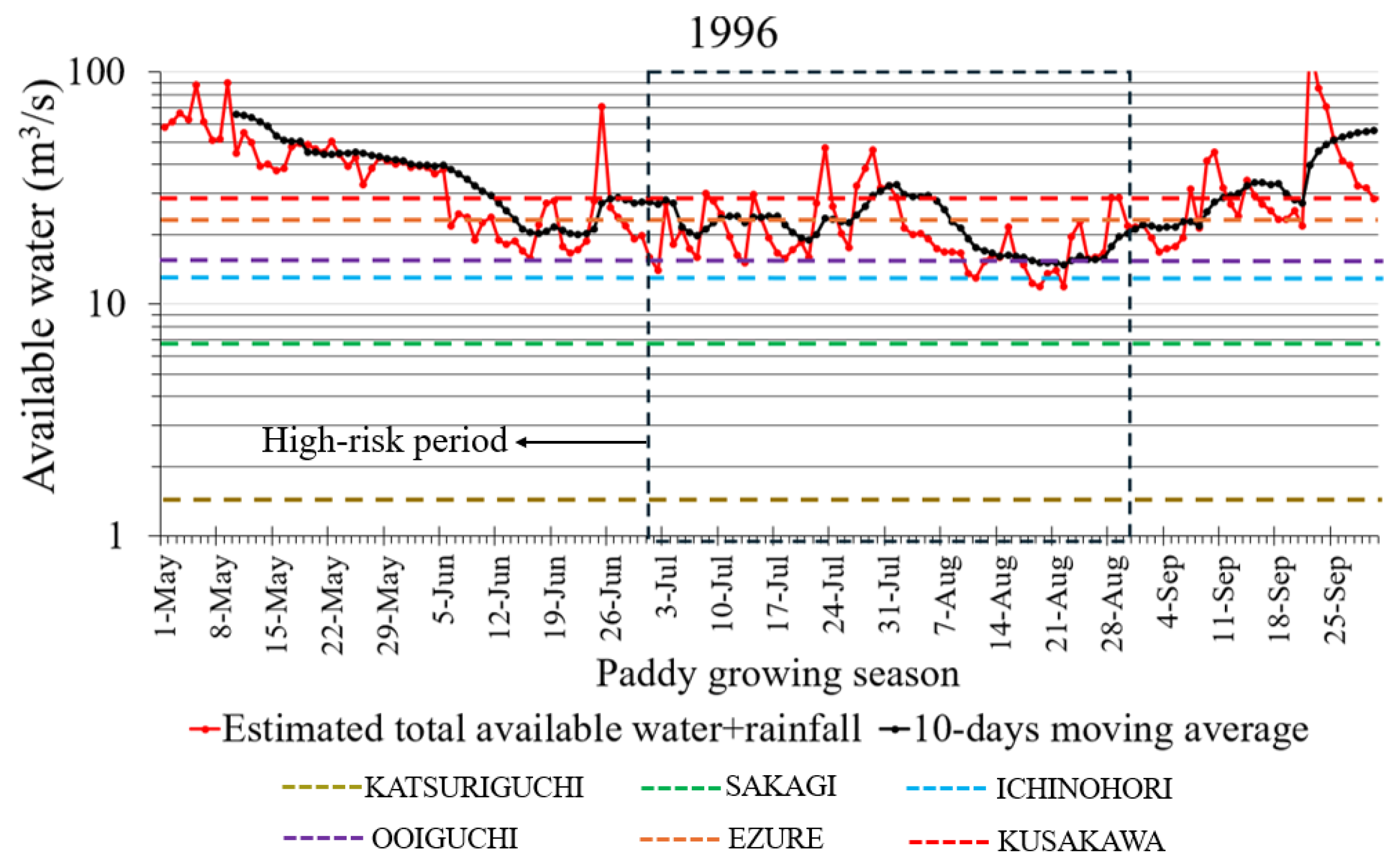
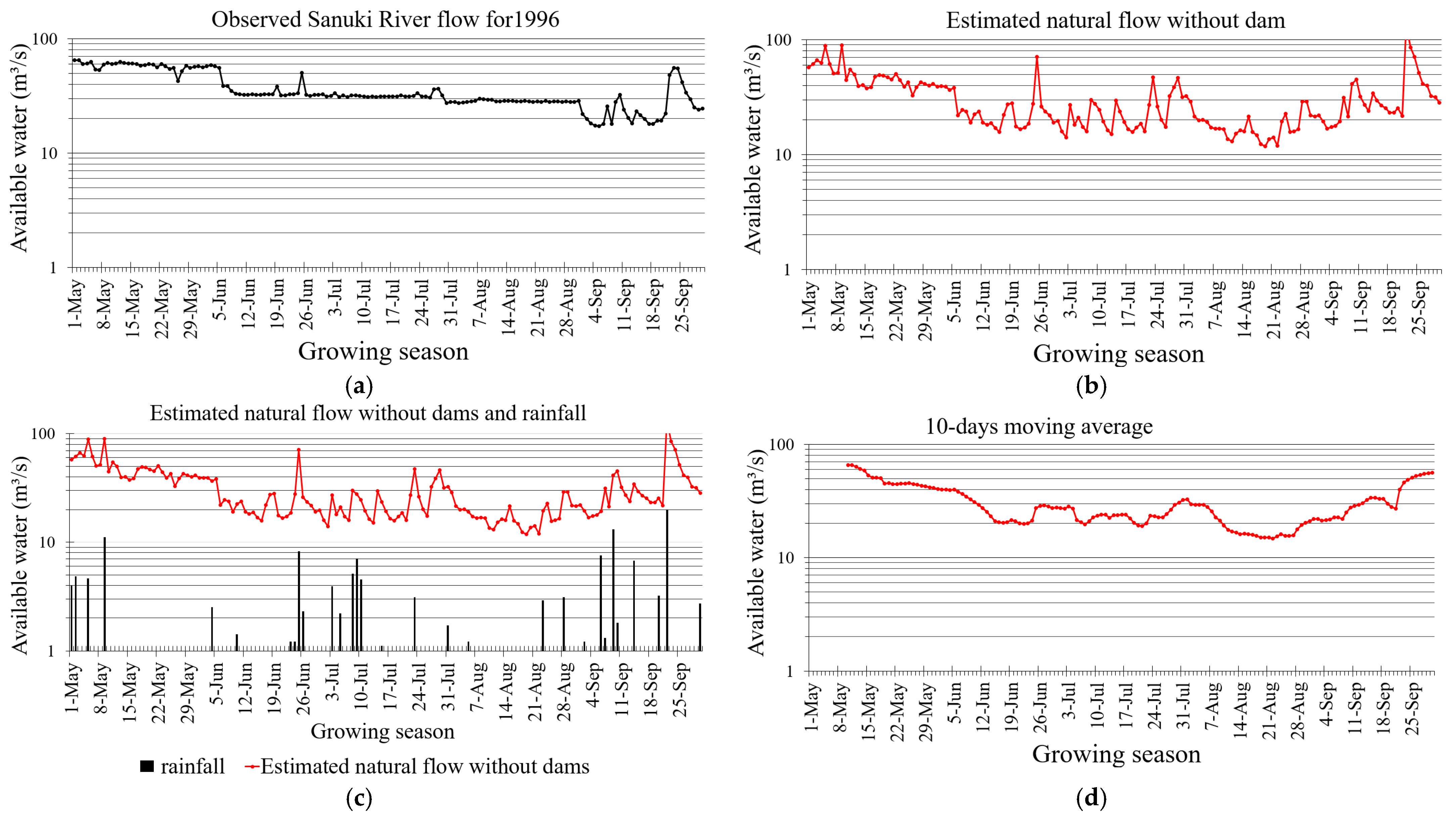
Using flow and rain data of 1996, the year in which the Sanuki River fluctuation easily shows the water scarcity areas, we reconstituted the water resources available during the pre-modern period. The reconstruction procedure is illustrated in Figure 5a–d.
-
Figure 5a presents the observed Sanuki River flow for 1996. Its stability demonstrates the influence of modern dams.
-
Based on this, we first estimated the natural flow conditions in the absence of the dam’s effect using Equation (1), as shown in Figure 5b.
-
Subsequently, we incorporated the 1996 daily rainfall data from the Utsunomiya AMeDAS station, located near the irrigation area, to estimate the total available water resources (Figure 5c).
-
Finally, recognizing that a continuous 10-day water shortage would cause significant damage to rice crops, we applied a 10-day moving average to the estimated flow values to assess temporal water stability (Figure 5d).
A comparison between Figure 5a,b indicates that, under pre-dam conditions, flow rates during the drought periods were considerably lower, ranging from approximately 10 m3/s to 18 m3/s, and that the duration of low-flow events was prolonged, persisting for 7 days. In the current situation with dams, the river flow during a drought is up to 25 m3/s. Using 1996 as a representative example, results show that the estimated pre-modern natural flow exhibited substantial fluctuations, reflecting unregulated hydrologic variability. In contrast, the actual recorded flow remained stable due to modern dam operations and storage control. This comparison highlights how infrastructural development has mitigated flow variability and reduced seasonal city risks in contemporary irrigation management.
Conversely, Figure 5d, which integrates rainfall data and applies a moving average, shows that the low-flow of river discharge is approximately 15 m3/s, and the duration of low-flow conditions is comparatively short, lasting only 2 days. This underscores the importance of accounting for both rainfall variability and temporal flow when assessing drought risk in pre-modern irrigation schemes.

3.3. Water Scarcity Risk Evaluation for Each Irrigation Scheme Using Flow Data in 1996

The reconstruction of pre-modern hydrological conditions in the Kinu River Basin aimed at approximating the natural river flow before the introduction of modern dams and engineered irrigation systems. Two allocation frameworks were examined to understand how water was managed under scarcity.
The first, the prior appropriation principle, reflected traditional Japanese governance that prioritized older irrigation schemes, ensuring their access to water before newer ones. The second, the equal water distribution system, represented cooperative management, with all schemes receiving uniform shares, emphasizing equity and collective stability. Together, these models capture how historical irrigation combines hierarchy with community-based coordination to maintain balance under hydrological constraints.
Water demand was evaluated at two operational levels: 20 mm/d, indicating standard irrigation for stable rice cultivation, and 5 mm/d, the minimum threshold for plant survival (evapotranspiration). These benchmarks illustrate how pre-modern systems functioned within strict limits on supply and conveyance efficiency, reinforcing the importance of cautious land expansion and adaptive field management to prevent water scarcity risk.
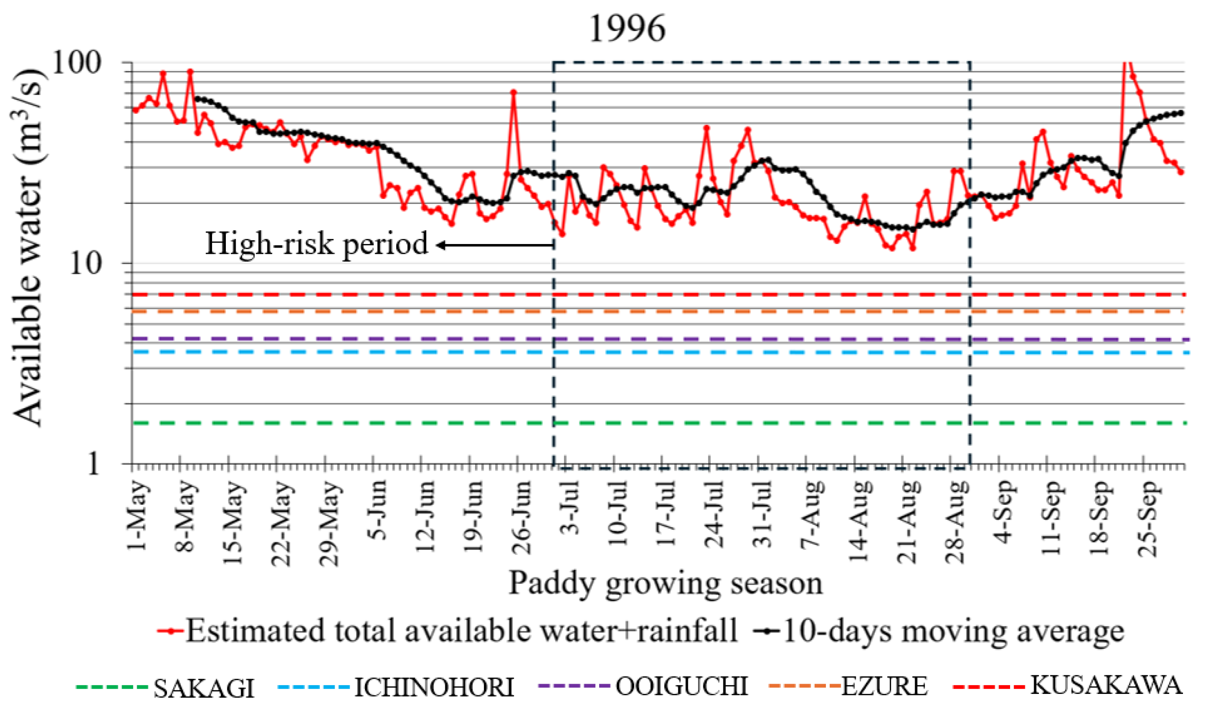
Under the 20 mm/d water demand, pronounced spatial differences emerge across the six schemes. The earlier-developed schemes of Katsuriguchi and Sakagi consistently meet their requirements because they divert water first under the prior appropriation principle, as shown in the two bottom lines, respectively (Figure 6). By contrast, downstream schemes, such as Ichinohori, Ooiguchi, Ezure, and especially Kusakawa, face deficits during July and August, when natural flow declines below 20 mm/day.
At the 5 mm/d of minimum water demand, no scarcity occurs in any irrigation scheme (Figure 7), indicating that pre-modern-era irrigation could avoid production losses even during low-flow years when water was managed intensively and cooperatively. This outcome suggests that sustaining rice cultivation under constrained natural flows depended less on hydrological abundance than on coordinated, basin-wide management that ensured rational delivery and equitable distribution. Maintaining irrigation at this minimum level, however, required intensive operational oversight by Water User Associations, including daily monitoring of canals, strict rotational scheduling, and enforcement against excessive withdrawals, demonstrating that the challenge at 5 mm/day was more about management practices than hydrologic conditions.

3.4. Water Scarcity Risk Evaluation Based on 17-Year Dataset

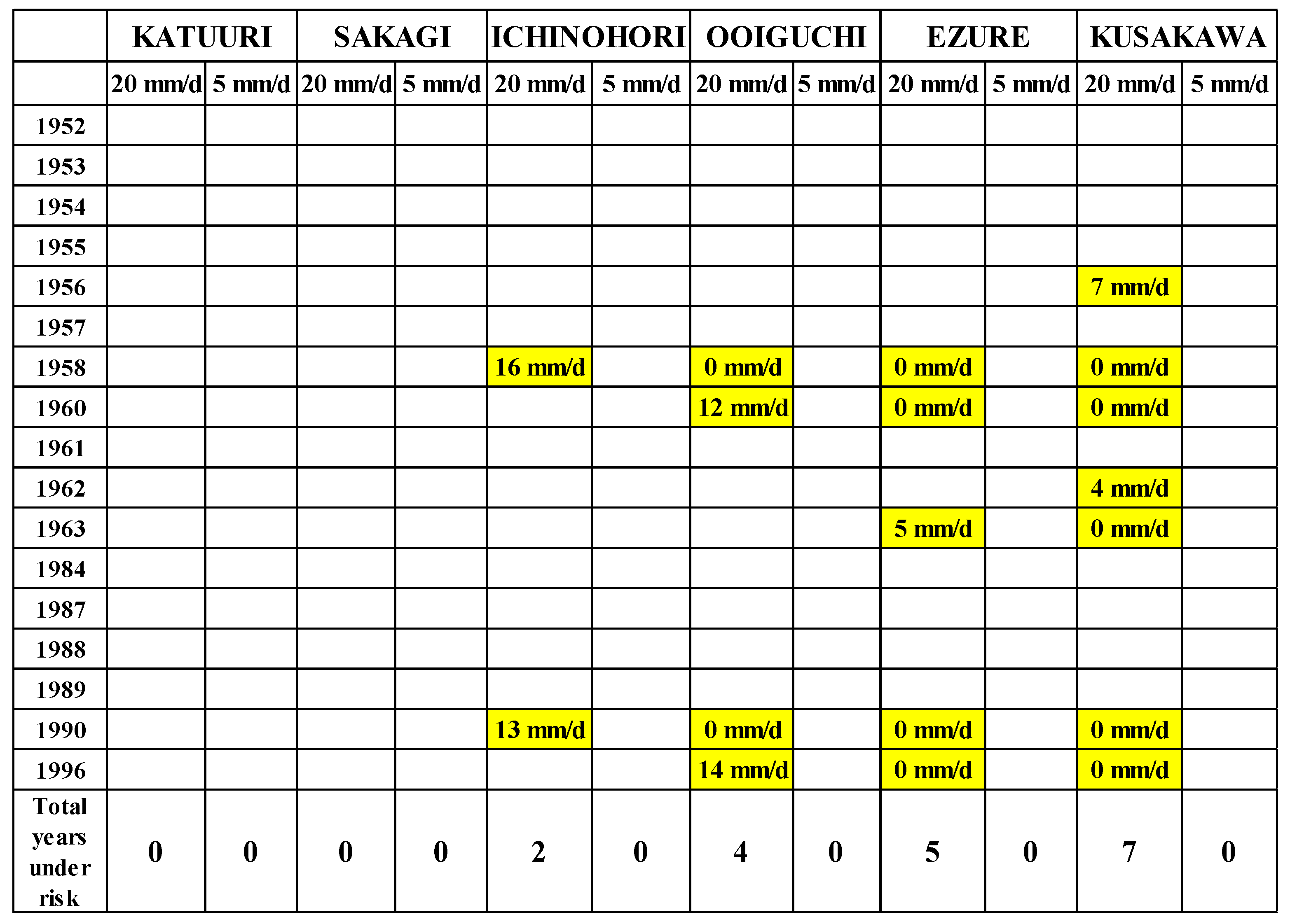
Following the evaluation process described in the methodology, water scarcity risk was assessed over 17 years, as shown in the Appendix A figures. Under a demand of 20 mm/day, scarcity occurred in 2/17 years from the third irrigation scheme (Ichinohori) and in 7/17 years from the last scheme (Kusakawa), indicating the need for intensive management to ensure water supply to all irrigation schemes.
With intensive management in the paddy field, the risk of water scarcity has been avoided. When demand was set at 5 mm/d, representing intensive management conditions, no scarcity events were observed, even during low flow years (Figure 8). Thus, there were no consecutive days with fewer than 5 mm/d. It implies that there is no damage to rice production in the pre-modern Kinu River Basin. The paddy field area in the Kinu River Basin has been developed within the extent of available water, suggesting a limited area-expansion policy in pre-modern times. In severe water conditions, intensive management activities, coordinated through mechanisms led by Water User Associations (WUAs), have been implemented to mitigate the risk.

4. Discussion

4.1. How Was the “Water Scarcity Risk” of the Irrigation Systems Along the Kinu River in the Pre-Modern Era?

In the Kinu River Basin, it was found that when water intake prioritizes older schemes (prior appropriation principle), the earlier developed two irrigation schemes can reliably secure over 20 mm/d of water resources (irrigation water + rainfall) annually. In the later-developed four irrigation schemes, the risk occurs in 2 out of 17 years for the third-developed irrigation scheme and in 7 out of 17 years for the last-developed irrigation scheme.
On the other hand, if all irrigation schemes reduced their water intake to 5 mm/d during drought (Equitable Water Distribution principle), there would be no risk of irrigation water shortages across all schemes.
Past research indicates that pre-modern rice production in Japan rarely decreased due to drought [9]. If this is true for the Kinu River Basin, it is plausible that water withdrawals were adjusted among irrigation schemes, at least during droughts, in the pre-modern period. Even then, as the available withdrawal water volume remains below 20 mm/d, intensive water distribution management within each irrigation scheme is likely indispensable to supply water to all paddy fields.
Thus, pre-modern water scarcity risk was not related to hydrological abundance, which enabled extensive water application and fewer management activities. But water scarcity in the pre-modern era can be considered at a level where, with intensive water distribution, all irrigation schemes can meet the minimum water requirement (5 mm/d for evapotranspiration) to avoid damage to rice production.

4.2. How Is the Impact of Climate Change on This Risk Evaluation?

In this study, the current dataset on river discharge, precipitation, and water demand (5 mm/d) was used to evaluate pre-modern water scarcity risk in Japan. As the pre-modern climate differs from the modern one, each component may affect the risk evaluation results. Precipitation and temperature affect the minimum water demand (evapotranspiration) due to changes between the two periods.
Regarding precipitation, previous research shows that it varies spatially, complicating its estimation and, in turn, river discharge [43].
On the other hand, long-term temperature changes mean meteorological data may differ from modern conditions, so minimum water demand should be considered [44]. Past research indicates that Japan’s Little Ice Age was cooler than today, and pre-modern temperatures were 1–2 °C lower than modern temperatures, reducing minimum water requirements (evapotranspiration) to 4 mm/d [28]. At this level, scarcity risk was assessed; under 20 mm/d demand, the risk persists in 5 of 17 years.
These findings show that climate change does not significantly affect risk evaluation. It reinforces the fact that the pre-modern system requires intensive management to supply water to all schemes.

4.3. How Should Japan’s System Be Evaluated from the PIM Aspect, or Adequate Water Use?

The Japanese management system is informative for other countries. In pre-modern Kinu River Basin irrigation schemes, the Equitable Water Distribution rules ensured that no damage was caused to rice production. Even with limited infrastructure, pre-modern Equitable Water Distribution maximizes the total product while securing the minimum water demand of 5 mm/d. It can be a valuable system for developing countries in the same way that historical research has recommended the essence of an irrigation management system based on the “Mura system” [11].
However, considering the total water use ratio, the Japanese PIM system is not useful. In a normal year, the water-use ratio is low, so the maximum total product is not achieved. No damage at 5 mm/d is related to the limitation of irrigable areas in the pre-modern period. At 20 mm/d, the available water is not fully used. It would be advantageous if the irrigable areas could be adjusted during a drought year. This must be integrated into water management practices in developing countries facing scarcity and food security challenges.

5. Conclusions

This study reconstructed pre-modern (Edo-period) natural flows at the Sanuki headwork to evaluate water scarcity risk for six large irrigation schemes in the Kinu–Kokai Basin. The analysis revealed the following findings.
  • At 20 mm/d of water demand, risk occurs in the later-developed four schemes, from 2 to 7 out of 17 years, while the earlier-developed two schemes are relatively secure, reflecting the disadvantage due to chronological development of the irrigation schemes rather than overall basin insufficiency.
  • Under the 5 mm/d minimum-need scenario, no scarcity events occurred even in low-flow years, suggesting that rice production could be maintained⁠ if allocation is coordinated to cover evapotranspiration for all schemes.
  • This can only be realized through intensive management activities that maximize the total productivity and avoid pre-modern yield failures.
As a recommendation, Equitable Water Distribution during shortages can be a helpful approach for developing countries. Stable social conditions are secure among irrigation schemes. However, in normal years, much water is not used for agricultural products and should be considered.

Author Contributions

Conceptualization, A.R.E., M.H.T., A.I. and Y.A.; methodology, A.R.E. and A.I.; software, A.R.E. and A.I.; validation, A.R.E., M.H.T., A.I. and Y.A.; formal analysis, A.R.E. and A.I.; investigation, A.R.E. and A.I.; resources, A.R.E. and A.I.; data curation, A.R.E. and A.I.; writing—original draft preparation, A.R.E. and A.I.; writing—review and editing, A.R.E., M.H.T., A.I. and Y.A.; visualization, A.R.E., M.H.T., A.I. and Y.A.; supervision, A.I. and Y.A.; project administration, A.R.E. and A.I.; funding acquisition, A.I. All authors have read and agreed to the published version of the manuscript.

Funding

This research was funded by JSPS KAKENHI Grant Number 22K05881.

Data Availability Statement

The dataset used for the analysis was obtained from the Ministry of Land, Infrastructure, Transport, and Tourism (MLIT) official website and the Land Improvement Districts offices (LIDs) in Japan. https://www1.river.go.jp/ (accessed on 5 November 2025), https://www.data.jma.go.jp/risk/obsdl/index.php (accessed on 5 November 2025).

Acknowledgments

The authors acknowledge the support and contributions of the Land Improvement Districts (LIDs) of irrigation schemes for their cooperation during data collection, materials, and interviews.

Conflicts of Interest

The authors declare no conflicts of interest, and the funders had no role in the design of the study; in the collection, analyses, or interpretation of data; in the writing of the manuscript; or in the decision to publish the results.

Appendix A. Water Scarcity Risk Evaluation for 17 Years Under the 5 mm/day of Minimum Water Demand

The appendix of this study presents a series of graphs illustrating the 17-year evaluation of water scarcity risk across the Kinu River Basin. These graphical results are included to ensure transparency and reproducibility of the research findings. Each graph displays water availability as calculated from the hydrological data recorded at the Sanuki headwork, which serves as the primary intake point for all six irrigation schemes in the basin. The water demand at Katsuriguchi is 5 mm/d, which is below 1 m3/s, so in this appendix, only five irrigation schemes are shown.
For the first four years of observation, the volume of water measured at Sanuki was considered equivalent to pre-modern conditions. The absence of reservoir regulation during that period supports this assumption, as the first upstream reservoirs did not begin operating until after 1957. Consequently, flow data from these early years is treated as a reliable representation of the natural, unregulated hydrological regime.
All evaluations were conducted under a standard water demand of 5 mm/d for each irrigation scheme, corresponding to the minimum evapotranspiration required to sustain rice cultivation. The situation was classified as a water scarcity event when the available water at Sanuki fell below 5 mm/day for 10 consecutive days during July and August, the period identified as the highest risk window for yield reduction due to water stress in paddy fields.
This appendix documents the interannual variability in water availability. It provides visual evidence supporting the study’s central conclusion: that pre-modern irrigation systems in the Kinu River Basin have maintained crop viability despite limited regulation, owing to adaptive management and equitable allocation practices.
Water 18 00179 i001aWater 18 00179 i001b

References

  1. Tanaka, Y.; Sato, Y. Farmers Managed Irrigation Districts in Japan: Assessing How Fairness May Contribute to Sustainability. Agric. Water Manag. 2005, 77, 196–209. [Google Scholar] [CrossRef] [Scilit]
  2. Ishiwatari, M.; Nagata, K.; Matsubayashi, M. Evolution of Water Governance for Climate Resilience: Lessons from Japan’s Experience. Water 2025, 17, 893. [Google Scholar] [CrossRef] [Scilit]
  3. Satoh, M.; Ishii, A. Japanese Irrigation Management at the Crossroads. Water Altern. 2021, 14, 413–434. [Google Scholar]
  4. Ishiwatari, M.; Nagata, K.; Matsubayashi, M. Evolving Water Resources Management in Response to Socio-Economic Changes: Japanese Experience in Modernization over the Past Century. Water Supply 2023, 23, 706–714. [Google Scholar] [CrossRef] [Scilit]
  5. Itsukushima, R. Historical Development and the Present Status of Japanese Dams. River Res. Appl. 2023, 39, 1136–1147. [Google Scholar] [CrossRef] [Scilit]
  6. Japan International Cooperation Agency (JICA). Water Use Management (Paper IX); Open JICA Report; JICA: Tokyo, Japan, 2004; Available online: https://openjicareport.jica.go.jp/pdf/11755576_08.pdf (accessed on 10 February 2024).
  7. Watanabe, H.; Mushime, A. Scenario-Type Low-Flow Management Methods. Suirikagaku (J. Water Resour. Sci.) 2008, 55, 22–33. [Google Scholar]
  8. Sarker, A. The Role of State-Reinforced Self-Governance in Averting the Tragedy of the Irrigation Commons in Japan. Public Adm. 2013, 91, 727–743. [Google Scholar] [CrossRef] [Scilit]
  9. Ekpelikpeze, A.R.; Ishii, A.; Satoh, M. The relationship between rice production and drought during the Edo period in Japan. J. Jpn. Soc. Irrig. Drain. Eng. 2023, 72, 479–480. [Google Scholar]
  10. Sarker, A.; Itoh, T. Design Principles in Long-Enduring Institutions of Japanese Irrigation Common-Pool Resources. Agric. Water Manag. 2001, 48, 89–102. [Google Scholar] [CrossRef] [Scilit]
  11. Kelly, W.W. Water Control in Tokugawa Japan: Irrigation Organization in a Japanese River Basin, 1600–1870 (East Asia Papers No.31); China-Japan Program; Cornell University: Ithaca, NY, USA, 1982. [Google Scholar]
  12. Foresight Synergy Network. Institutions and the Commons (Third Final Draft, November 2013). FSN Background Paper. 2013. Available online: https://fsncanada.com/wp-content/uploads/2023/01/ostrom-institutions-commons-third-final-draft-2013-nov-2013.pdf (accessed on 20 November 2025).
  13. Sarker, A.; Itoh, T. The Nature of the Governance of Japanese Irrigation Common-Pool Resources. Soc. Nat. Resour. 2003, 16, 159–172. [Google Scholar] [CrossRef] [Scilit]
  14. Maejima, I.; Tagami, Y. Climate of Japan; University of Tokyo Press: Tokyo, Japan, 1986; Available online: https://www.u-tokyo.ac.jp/en/ (accessed on 25 November 2025).
  15. Mizukoshi, M. Climatic reconstruction in historical times based on documentary sources. Geogr. Rev. Jpn. 1993, 66, 353–369. [Google Scholar]
  16. Sho, K.; Tominaga, T. Climatic variations inferred from historical diaries in Japan. Geogr. Rev. Jpn. 2004, 77, 579–593. [Google Scholar]
  17. Tsuchiya, R.; Kato, T.; Jeong, J.; Arnold, J.G. Development of SWAT-Paddy for Simulating Lowland Paddy Fields. Sustainability 2018, 10, 3246. [Google Scholar] [CrossRef] [Scilit]
  18. Water Resource Division; Rural Infrastructure Department; Rural Development Bureau; Ministry of Agriculture; Forestry and Fisheries (MAFF). The History of Agricultural Water and Water Rights. Available online: https://www.maff.go.jp/j/nousin/mizu/kurasi_agwater/k_agri/pdf/detail_en.pdf (accessed on 25 November 2025).
  19. OECD. OECD Reviews of Regulatory Reform—Japan: Challenge of Structural Reform. Covers Water Governance Aspects. 2006. Available online: https://www.oecd.emb-japan.go.jp/pdf/Tainichikisei072004English.pdf (accessed on 20 November 2025).
  20. Luo, P.; Takara, K.; Apip, A.; He, B.; Nover, D.; Yamashiki, Y. Land use change analysis and paleo-flood in the Kamo River basin, Kyoto, Japan. J. Jpn. Soc. Civ. Eng. Ser. B1 (Hydraul. Eng.) 2012, 68, I_22–I_27. [Google Scholar] [CrossRef] [Scilit]
  21. Rao, M.P.; Cook, E.R.; Cook, B.I.; D’Arrigo, R.D.; Palmer, J.G.; Lall, U.; Woodhouse, C.A.; Buckley, B.M.; Uriarte, M.; Bishop, D.A.; et al. Seven centuries of reconstructed Brahmaputra River discharge demonstrate underestimated high discharge and flood risk in the Bengal delta. Proc. Natl. Acad. Sci. USA 2020, 117, 32986–32992. [Google Scholar] [CrossRef] [Scilit]
  22. Oliva, M.; Ruiz-Fernández, J.; Barriendos, M.; Benito, G.; Cuadrat, J.; Domínguez-Castro, F.; García-Ruiz, J.; Giralt, S.; Gómez-Ortiz, A.; Hernández, A.; et al. Palaeoflood hydrology: Progress and perspectives. Earth-Sci. Rev. 2018, 177, 97–119. [Google Scholar] [CrossRef] [Scilit]
  23. Mikami, T. Climatic reconstruction in historical times based on weather records. Geogr. Rev. Jpn. (Ser. B) 1988, 61, 14–22. [Google Scholar] [CrossRef] [Scilit]
  24. Nakatsuka, T.; Sano, M.; Li, Z.; Xu, C.; Tsushima, A.; Shigeoka, Y.; Sho, K.; Ohnishi, K.; Sakamoto, M.; Ozaki, H.; et al. A 2600-year summer climate reconstruction in central Japan by integrating tree-ring stable oxygen and hydrogen isotopes. Clim. Past 2020, 16, 2153–2172. [Google Scholar] [CrossRef] [Scilit]
  25. Iizuka, H.; Sho, K.; Li, Z.; Sano, M.; Kato, Y.; Nakatsuka, T. Reconstruction of drought and long-rain chronologies since the 17th century in central Japan using intra-annual tree-ring oxygen isotope ratios and documentary records. Clim. Past 2025, 21, 133–152. [Google Scholar] [CrossRef] [Scilit]
  26. Takara, K.; Kim, S.; Tachikawa, Y.; Nakakita, E. Assessing climate change impact on water resources in the Tone River Basin, Japan, using super-high-resolution atmospheric model. Hydrol. Res. Lett. 2009, 3, 65–69. [Google Scholar] [CrossRef] [Scilit]
  27. De Silva, C.; Weatherhead, E.; Knox, J.; Rodriguez-Diaz, J. Predicting the impacts of climate change--A case study of paddy irrigation water requirements in Sri Lanka. Agric. Water Manag. 2007, 93, 19–29. [Google Scholar]
  28. Ikawa, H.; Ono, K.; Mano, M.; Kobayashi, K.; Takimoto, T.; Hayashi, K. Evapotranspiration in a rice paddy field over 13 crop years. Jpn. J. Agric. Meteorol. 2017, 73, 109–121. [Google Scholar] [CrossRef] [Scilit]
  29. Allen, R.G.; Pereira, L.S.; Raes, D.; Smith, M. Crop Evapotranspiration—Guidelines for Computing Crop Water Requirements; FAO Irrigation and Drainage Paper 56; Food and Agriculture Organization of the United Nations: Rome, Italy, 1998; Available online: https://www.fao.org/3/x0490e/x0490e00.htm (accessed on 1 November 2025).
  30. IPCC. Climate Change 2021: The Physical Science Basis. Contribution of Working Group I to the Sixth Assessment Report of the Intergovernmental Panel on Climate Change; Masson-Delmotte, V., Zhai, P., Pirani, A., Connors, S.L., Péan, C., Berger, S., Caud, N., Chen, Y., Goldfarb, L., Gomis, M.I., et al., Eds.; Cambridge University Press: Cambridge, UK, 2021. [Google Scholar]
  31. Peng, D.D.; Zhou, T.-J.; Hu, S.; Zhang, L.X.; Zheng, J.Y.; Qu, J.X. Temperature and precipitation change over South China in CMIP5 and CMIP6 models: Historical simulation and future projection. Adv. Atmos. Sci. 2025, 42, 1423–1441. [Google Scholar] [CrossRef] [Scilit]
  32. Mikami, T. Climatic variations in Japan reconstructed from historical documents. Weather 2008, 63, 190–195. [Google Scholar] [CrossRef] [Scilit]
  33. JICA. Water Use Management (Paper IX); Final Report; Japan International Cooperation Agency: Tokyo, Japan, 2004; Volume II. [Google Scholar]
  34. Ministry of Land, Infrastructure and Transport (MLIT), River Bureau. Technical Criteria for River Works: Planning; Ministry of Land, Infrastructure and Transport (MLIT), River Bureau: Tokyo, Japan, 2005. [Google Scholar]
  35. Kudo, R.; Yoshida, T.; Masumoto, T. Nationwide assessment of the impact of climate change on agricultural water resources in Japan using multiple emission scenarios in CMIP5. Hydrol. Res. Lett. 2017, 11, 31–36. [Google Scholar] [CrossRef] [Scilit]
  36. Bwambale, E.; Home, P.G.; Raude, J.M.; Wanyama, J. Hydraulic performance evaluation of the water conveyance system of Doho Rice Irrigation Scheme in Uganda. J. Sustain. Res. Eng. 2019, 5, 101–112. [Google Scholar]
  37. Ayella, P.; Ishii, A.; Satoh, M. Effects of Irrigation Water Sufficiency on Water Fee Collection Rate in Uganda’s Large-Scale Paddy Irrigation Schemes. Water 2022, 14, 1611. [Google Scholar] [CrossRef] [Scilit]
  38. Khalifa, E.M.; Eltawil, M.A.; El-Marsafawy, S.; Abou Ali, M. Enhancing the irrigation water management using developed irrigation canals. J. Soil Sci. Agric. Eng. 2009, 1, 901–913. [Google Scholar] [CrossRef] [Scilit]
  39. Nougyou Suiri Kenkyukai. Nihon no Nougyou Yousui; Chikyusha: Tokyo, Japan, 1980; pp. 29–39. (In Japanese) [Google Scholar]
  40. Satoh, M. History of Irrigation Management in Japan; Rural Culture Association Press: Tokyo, Japan, 1984. (In Japanese) [Google Scholar]
  41. Ministry of Land, Infrastructure, Transport and Tourism, Hydrological and Water Quality Database. 2024. Available online: https://www1.river.go.jp/ (accessed on 5 June 2024).
  42. JMA AMeDAS. 2024. Available online: https://www.data.jma.go.jp/risk/obsdl/index.php (accessed on 5 June 2024).
  43. Lee, G.; Tachikawa, Y.; Takara, K. Effects of spatial variability of rainfall on catchment responses in distributed rainfall–runoff modeling. J. Hydrol. 2009, 372, 207–218. [Google Scholar]
  44. Dalai, A.; Tripathi, M.P.; Mishra, A.; Chand, S.; Venkataramana, B.; Nayak, J.K. Assessing the Impact of Climate Change on Irrigation Water Needs Through Conjunctive Water Use: Future Prospectives. Water 2025, 17, 2622. [Google Scholar] [CrossRef] [Scilit]
Figure 1. Location of the study site. The five-pointed start and the black circle show respectively the location of the irrigation schemes and the rainfall measurement station.
Water 18 00179 g001
Figure 2. River flow reconstruction approach.
Water 18 00179 g002
Figure 3. Correlation between rainfall at Nikko station and river flow at Sanuki.
Water 18 00179 g003
Figure 4. Recreation of the modern water source and waterways in the Kinu River Basin: (a) Current irrigation network system; (b) pre-modern irrigation network system.
Water 18 00179 g004
Figure 5. Process of reconstruction of pre-modern water resources using the dataset 1996: (a) Observed Sanuki river flow for 1996; (b) Estimated natural flow without dam; (c) Estimated natural flow without dam and rainfall; (d) 10-days moving average.
Water 18 00179 g005
Figure 6. Water scarcity risk at 20 mm/d of water demand using data from the year 1996.
Water 18 00179 g006
Figure 7. Water scarcity risk at 5 mm/d of water demand using data from the year 1996.
Water 18 00179 g007
Figure 8. Risk evaluation based on prior appropriation and equal water distribution for 17 years. Note: The value in Figure 8 represents the available water for the irrigation scheme based on the prior appropriation principle.
Water 18 00179 g008
Table 1. Large irrigation schemes were established in the pre-modern era of Japan.
Construction YearsIrrigation SchemesIrrigation Schemes Areas (ha)
1617Katsuriguchi500
1620Sakagi1720
1656Ichinohori2336
1698Ooiguchi1000
1791Ezure2091
~1800sKusakawa1568
Disclaimer/Publisher’s Note: The statements, opinions and data contained in all publications are solely those of the individual author(s) and contributor(s) and not of MDPI and/or the editor(s). MDPI and/or the editor(s) disclaim responsibility for any injury to people or property resulting from any ideas, methods, instructions or products referred to in the content.