Article

Evaluating Infiltration Ponds for Flood Mitigation and Aquifer Recharge in an Urban Area

1
National Laboratory for Water Science and Water Security, Department of Sanitary and Environmental Engineering, Faculty of Civil Engineering, Budapest University of Technology and Economics, 1111 Budapest, Hungary
2
Department of Sanitary and Environmental Engineering, Faculty of Civil Engineering, Budapest University of Technology and Economics, 1111 Budapest, Hungary
3
National Laboratory for Water Science and Water Security, Institute for Soil Sciences, HUN-REN Centre for Agricultural Research, 1116 Budapest, Hungary
4
Institute for Soil Sciences, HUN-REN Centre for Agricultural Research, 1116 Budapest, Hungary
5
National Laboratory for Water Science and Water Security, Department of Circular Economy and Environmental Technology, Institute of Water and Environmental Management, Faculty of Agricultural and Food Sciences and Environmental Management, University of Debrecen, 4032 Debrecen, Hungary
6
Department of Circular Economy and Environmental Technology, Institute of Water and Environmental Management, Faculty of Agricultural and Food Sciences and Environmental Management, University of Debrecen, 4032 Debrecen, Hungary
*
Author to whom correspondence should be addressed.
Water 2026, 18(16), 2006; https://doi.org/10.3390/w18162006
Submission received: 11 June 2026 / Revised: 5 August 2026 / Accepted: 14 August 2026 / Published: 17 August 2026
(This article belongs to the Section Urban Water Management)

Abstract

Climate change and rapid urbanisation increasingly threaten urban water security and grey infrastructure, calling for adaptive stormwater strategies to mitigate hydroclimatic extremes. This study evaluates the hydrologic performance of decentralised infiltration ponds functioning as natural/small water retention measures in the regional recharge zone of the Nyírség region, Debrecen, Hungary. Using a sensor-calibrated Hydrus-1D model, we simulated a no-intervention baseline against three pond sizes across historical and mid-century regional climate model projections. While the baseline scenario yielded negligible deep percolation across all scenarios, the smallest infiltration pond resulted in increased vertical moisture flux. The infiltration pond simulation improved ET/PET ratios and increased root zone saturation, improving urban vegetation health and evaporative cooling. All the pond designs attenuated and stored runoff without overspilling. Emission pathway sensitivity showed different responses driven by regional climate scenarios; temperature-driven evaporative offsets dominated under moderate warming, whereas extreme precipitation intensity increased infiltration gains under higher emissions. These findings support infiltration ponds as resilient, dual-purpose measures for mitigating regional water table decline while providing local flood protection under changing climate futures.

1. Introduction

Hydroclimatic swings between dry and wet extremes due to climate change have become increasingly apparent in recent decades [1,2]. These climate changes pose a significant threat to urban water resources management and infrastructure. Conventional, centralised, and rigid water management systems are even more vulnerable to these extreme events due to the high proportion of impervious surfaces and increasing population density [3,4,5]. Traditional stormwater management systems were not originally designed to cope adequately with climate-induced extreme hydroclimatic events; as a result, they frequently underperform during high-intensity storms [6]. For example, urban stormwater drainage systems are increasingly unable to cope with intensified rainfall events, resulting in frequent overloads and localised urban flooding caused by undersized sewers designed using outdated methods [7]. Consequently, there is an urgent need to move towards sustainable, adaptive, and decentralised strategies that simultaneously support stormwater management, mitigate urban flooding, enhance infiltration, and conserve local water resources [8].
For urban areas such as Debrecen, this shift is imperative. Mid-century climate projections anticipate a 1–°C increase in annual temperatures and highly variable, intense precipitation [9]. These projected climate shifts threaten to accelerate pluvial flooding, groundwater depletion, and drive the expansion of drought-prone areas, particularly across the arid Great Hungarian Plain [9]. The dichotomous nature of climate change poses a challenge to traditional and uniform water management strategies, as they are not holistically equipped to address the dual threat of intensifying water deficits and flash flooding [10]. The EU Water Strategy, Hungary’s Jenő Kvassay Plan, and regional research initiatives such as the National Laboratory for Water Science and Water Security create an enabling environment for sustainable water management [11,12,13,14]. Natural water retention and sustainable urban stormwater management thus serve as the principal strategies through which these policies address hydroclimatic extremes and secure long-term water resource sustainability.
Natural or Small Water Retention Measures (NSWRMs), such as infiltration ponds, embody these regulatory policies and are recognised as measures to buffer hydroclimatic extremes [15,16]. Infiltration ponds offer a decentralised means to improve local water storage, enhance infiltration, reduce runoff, and mitigate both drought and flood risks. These measures detain, slow down, and allow stormwater to infiltrate into the subsurface, supporting flood control and local groundwater recharge [17,18,19,20]. Such aquifer recharge interventions increase water availability within the vadose zone and improve river flow regimes [21,22].
The effectiveness of infiltration measures largely depends on the soil hydraulic properties, local climatic boundary conditions, and the magnitude and temporal distribution of rainfall inputs. NSWRMs are recommended as cost-effective climate adaptation strategies [17,18,23]; their long-term performance under projected climate change remains insufficiently explored, particularly regarding design layout optimisations where shifts in rainfall intensity and evaporative demand may alter infiltration efficiencies. This study aims to bridge this gap by conducting a pre-implementation scoping study using numerical modelling tools to optimise interventions.
The soil hydraulic properties of the subsurface primarily govern the effectiveness of NSWRM. However, characterising these properties is inherently complex, as subsurface fluid transport often exhibits significant non-linear features and dynamic instability. Recent studies using bifurcation dynamical analysis indicate that seepage stability can transition from steady states to complex periodic or chaotic oscillations depending on structural parameters and pressure gradients [24]. Furthermore, soil hydraulic properties are not static; external stressors such as extreme thermal cycling or high-intensity hydrological loading projected in climate projections can induce cumulative structural damage, fundamentally altering porosity and permeability over time [25]. Beyond these temporal evolutions, soil hydraulic properties show considerable spatial variability across landscapes due to heterogeneity in parent material, topography, and vegetation [26,27,28]. In particular, saturated hydraulic conductivity is highly variable spatially, which limits and complicates the application of hydrological models on larger scales [26].
Quantifying soil water content (SWC) dynamics is essential for evaluating the performance of infiltration ponds and optimising the design, planning, and implementation of these measures. SWC regulates the partitioning of rainfall into infiltration, evapotranspiration, runoff, and deep percolation [29,30]. Evaluating these transient, variably saturated flow processes requires numerical tools capable of resolving flow dynamics within the vadose zone. Hydrus-1D is widely used for this purpose, providing a physically based framework for simulating one-dimensional water movement using the Richards equation and soil hydraulic functions [29,31,32,33].
While the performance of infiltration systems has been studied globally [17,18,19,20], this research provides a novel contribution by evaluating decentralised infiltration ponds through a sensor-calibrated Hydrus-1D model of a disturbed urban soil profile. By integrating in situ soil moisture monitoring from an urban campus environment with mid-century regional climate model projections, the study addresses a critical gap in the existing literature regarding the long-term resilience of NSWRM in the Great Hungarian Plain. Furthermore, by evaluating the sensitivity of different pond sizes, this study provides the first numerical evidence for optimising decentralised retention measures to mitigate regional water table declines in Hungary’s critical recharge zones.
This study addresses current gaps by modelling the long-term soil moisture response to infiltration ponds of different sizes under historical and projected climate conditions in Debrecen. Specifically, the study evaluates how pond area influences deep percolation and potential groundwater recharge using cumulative bottom flux, root-zone saturation, and evapotranspiration dynamics across a range of hydroclimatic scenarios. Combining high-quality soil data and soil hydraulic parameters derived from field and laboratory measurements has allowed this predictive modelling approach to provide a strong baseline evaluation of infiltration pond performance.
The current study aims to evaluate the effectiveness of infiltration ponds of different sizes in enhancing water retention and infiltration under historical and projected climate conditions. The specific objectives of this study were to: (1) set up and calibrate a Hydrus-1D model for a representative urban campus site in Debrecen; (2) simulate the long-term behaviour of infiltration ponds of different sizes (500 m2, 750 m2, 1000 m2); and (3) quantify the effectiveness of these ponds in enhancing deep percolation and improving soil moisture conditions under historical and projected climate scenarios. Through this approach, the study provides evidence-based insights for the optimisation of small water retention interventions. It aligns with the objectives of the National Laboratory for Water Science and Water Security project.

2. Materials and Methods

The study area, situated in the Nyírség region of the Great Hungarian Plain, represents a critical regional recharge zone characterised by downward vertical moisture flux and a persistent negative water balance (Figure 1). The reference soil profile is located in Debrecen. The terrain is defined by a gently undulating medium–high lowland topography, with elevations typically ranging between 85 and 175 m above sea level and a regional decline from the north-northeast toward the south-southwest [21,34]. This landscape consists of an alluvial fan plain shaped primarily by aeolian processes, which have created a surface of shifting sand and sandy loess punctuated by distinctive rim and parabolic dunes. These morphological features are horizontally divided by north-northeast to south-southwest-oriented valleys, which, alongside the elevated dunes, act as local topographic high points driving gravity-influenced groundwater infiltration [34]. In the upper 2–300 m of the subsurface, the vertical pressure gradient is smaller than hydrostatic, confirming a topography-driven downward moisture flux induced by the elevated hills of the Nyírség to the north [34]. Because the infiltrating water moves away from these elevated regions toward deeper discharge areas to the south, the local water table is highly dependent on continuous recharge, resulting in a negative water balance.
The landscape of the study area is characterised by dominant soil textures including sand, sandy loam, loam, clay loam, clay, and peat [34]. In recent decades, the region has seen a significant groundwater deficit of 5–6 km3, driven by the dual stressors of climate change and anthropogenic activities such as intensive canalisation and urban water overexploitation around Debrecen [21]. These factors have led to a decline in the regional water table, which threatens to diminish local flow systems and has already resulted in the widespread desiccation of climate-vulnerable wetlands. The area is characterised by a humid continental climate with an average annual precipitation and temperature of 546 mm and 22.7 °C, respectively [34].
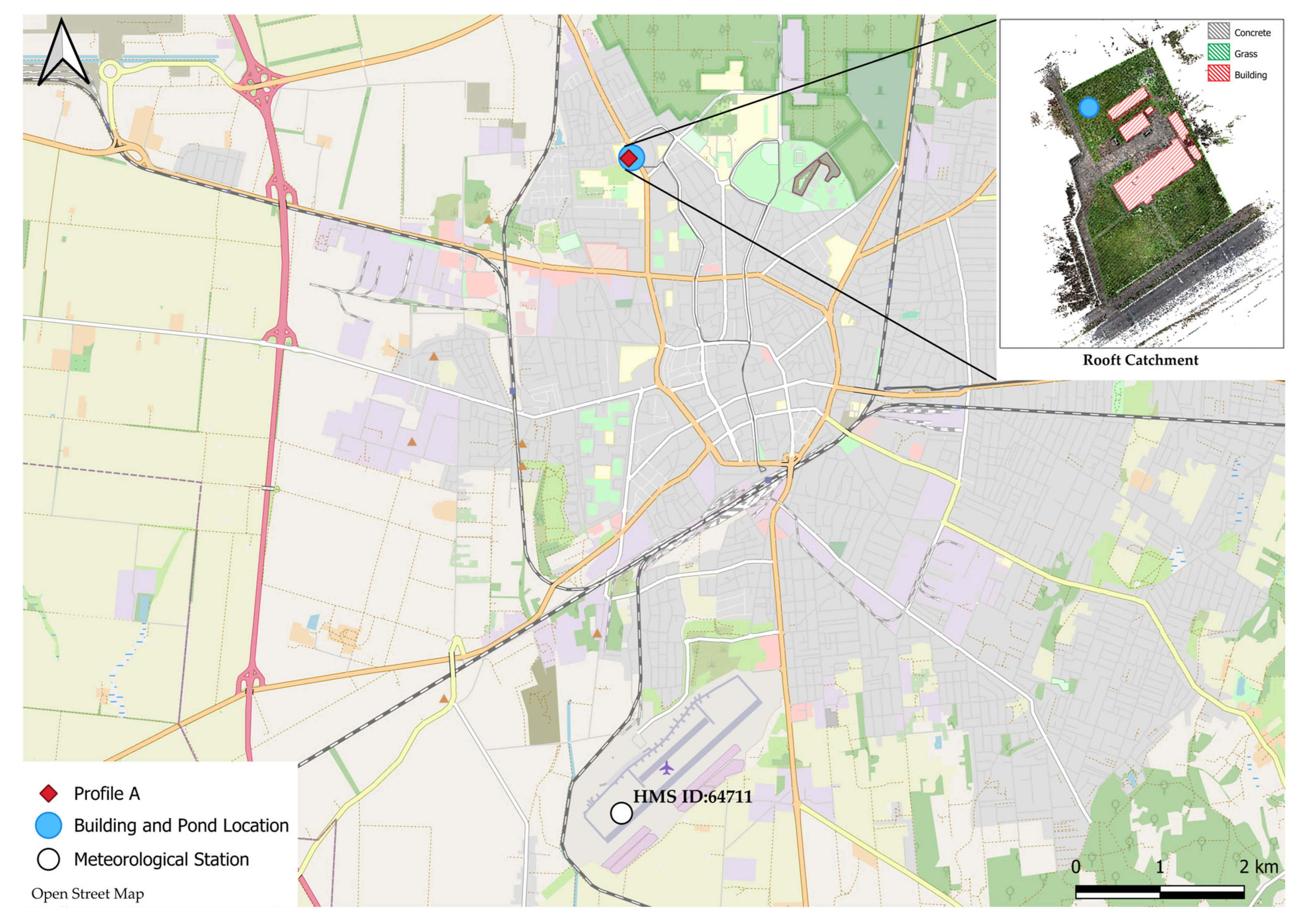
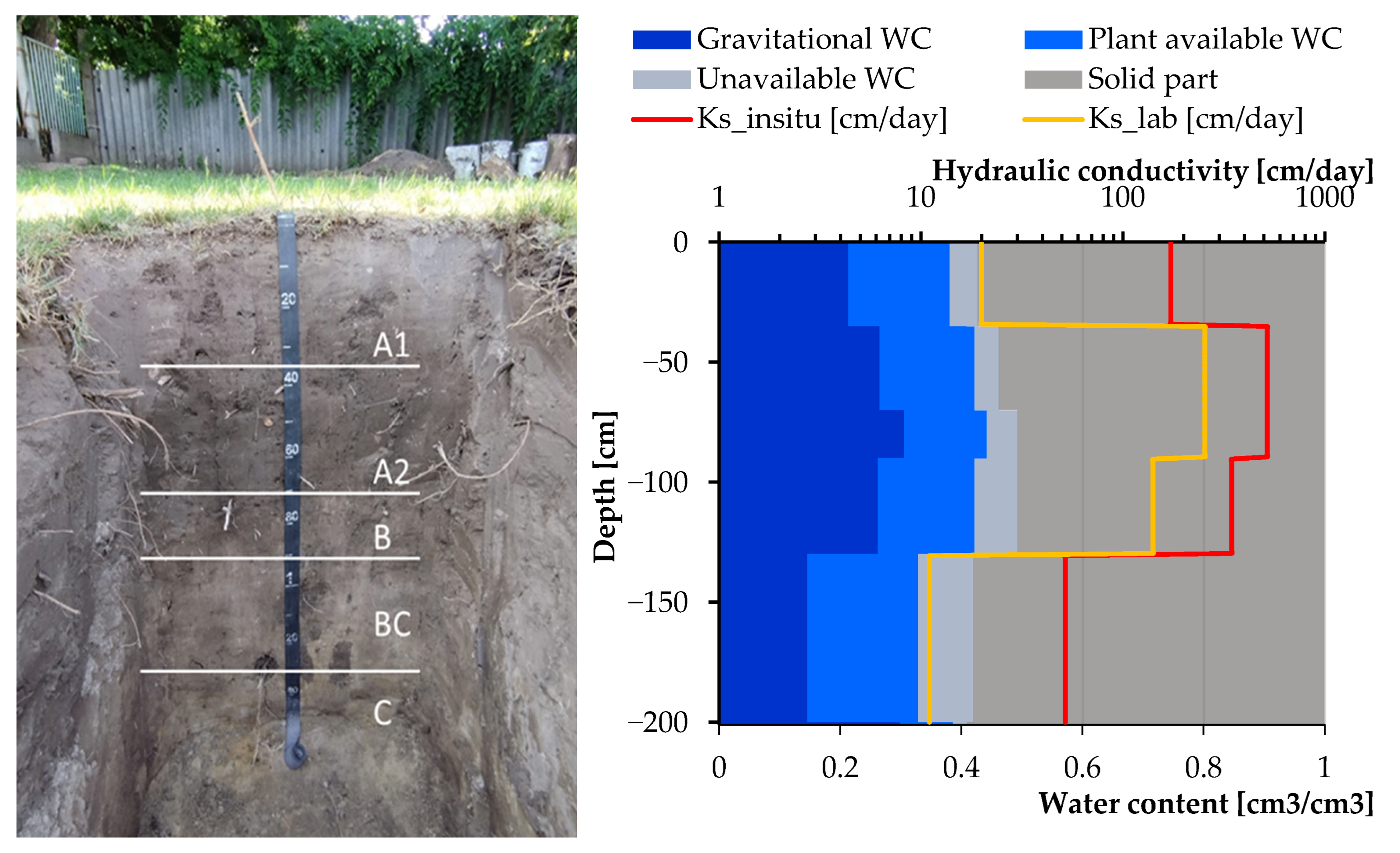
The reference profile (Soil Profile A) located within the University of Debrecen Campus was monitored for soil moisture and hydrologic modelling. The location map of the study area, in situ photographic documentation of the soil profile, and numerical representations detailing the vertical distribution of the soil hydraulic parameters are provided in Appendix A (Figure A1).
Soil profile surveys, soil sampling, and laboratory measurements were conducted for this site to determine soil physical and hydraulic properties. GroPoint time-domain transmission (TDT) soil moisture sensors (RioT Technology Corp, North Saanich, BC, Canada) were calibrated and installed at four depths within the profile to measure the continuous volumetric water content (cm3/cm3), as specified in Table 1. Soil Profile A is situated in an area that used to be an orchard, and currently, the vegetation is dominated by grasses, legumes, and various herbaceous species. Carbonate formations were observed in both the surface soil horizon and the deposition materials. The soil profile extends to a total depth of 150 cm with five horizons (A1, A2, B, BC, and C). The organic-rich humus layer extends to a depth of 70 cm, indicating significant organic matter accumulation. Physical and chemical properties for each horizon are detailed in Table 1.
The Hydrus-1D model is a physically based, process-driven tool used to describe water movement in variably saturated porous media [33,35,36]. It solves the one-dimensional vertical Richards equation for water movement:
θ ( h ) t = x k h h x + 1 S h  
where θ(h) is the volumetric water content (cm3/cm3) at the matrix potential level h (cm); t is the time (day); x is the vertical spatial coordinate (cm); k(h) is unsaturated hydraulic conductivity (cm/day); and S(h) is the sink term ( day 1 ) applied to account for root water uptake.
The soil hydraulic functions were parameterised using the van Genuchten-Mualem formulation:
θ h = θ r + θ s θ r 1 + | α h | n m , h < 0 θ s , h 0
K h = K s . S e l 1 1 S e 1 m m   2
S e = θ θ r θ s θ r
where θ r is the residual water content (cm3/cm3); θ s is the saturated water content (cm3/cm3); α ( cm 1 ), n ( ), m = 1 1 / n , and l ( ) are empirical van Genuchten parameters; Ks is the saturated hydraulic conductivity (cm/day); and Se is the effective saturation.
The RETention Curve (RETC) program (Version 6.02) was used to estimate soil hydraulic parameters for each horizon based on in situ and laboratory-measured soil water retention data derived from sampled physical cores. Within the RETC environment, the van Genuchten parameters were optimised and integrated into the Hydrus-1D model. While this model uses high-resolution parameters derived from site-specific field and laboratory measurements optimised via RETC, it is acknowledged that soil hydraulic parameters behave differently across the landscape [26]. To compare these local findings with heterogeneous porous media in future work, scaling techniques can be employed to coalesce multiple hydraulic equations into a single reference framework [37].
Hydrus-1D (Version 4.17) was set up with an atmospheric upper boundary that included precipitation and potential evapotranspiration fluxes, and a free-drainage lower boundary to simulate natural percolation. The model domain was extended to 300 cm to minimise the influence of the free-drainage lower boundary condition, adopted from Guram and Bashir [38], and to enable detailed vertical discretisation for accurate water budget modelling, as highlighted by Kozma et al. [31]. Extending the model domain below the deepest monitoring sensor ( 140   cm ) and soil horizon (150 cm) eliminates artificial boundary reflections on simulated root zone dynamics. The Nyírség region’s regional recharge setting places the groundwater table well below the modelled domain, justifying the use of a free drainage lower boundary in Hydrus-1D [21]. This setup not only prevents boundary effects on root zone dynamics but also reasonably simulates infiltration and deep percolation. Although short-term local groundwater fluctuations may occur, the approach captures main vadose zone water processes while balancing model complexity and computational efficiency given the hydrogeological data and the regional groundwater regime.
The model was simulated for 19 months, beginning with a four-month spin-up period to mitigate initial condition anomalies and capture antecedent moisture dynamics, followed by 15 months of calibration using observed data. Using the complete observational dataset for calibration was important for capturing the transient soil water dynamics and vertical moisture continuum across all four monitored horizon depths. Crucially, the dataset captures multiple high-intensity precipitation peaks as well as extended drought-induced drawdowns, providing an empirical basis for the reliable 2 estimation of soil hydraulic parameters under contrasting hydroclimatic extremes.
A constant Leaf Area Index (LAI) of two was used throughout the simulation period. This was done to maintain a baseline constraint that isolates subsoil hydraulic performance and vertical drainage capacity from uncertainties arising from highly non-linear vegetative feedback [39]. In standard agronomic and hydrological frameworks, an active area dominated by herbaceous plants maintains an effective LAI within the 2.0–2.5 range, making a static value of two an established and generalised baseline for healthy ground cover [40].
The calibrated model was used to assess decentralised stormwater mitigation; an infiltration pond was conceptualised to receive runoff harvested from the rooftops of surrounding campus buildings. The rooftop catchment area, measuring 695 m2, was mapped using the X120GO handheld laser scanner (Stonex, Milan, Italy) to derive the exact contributing geometry. To evaluate design sensitivities, three infiltration ponds were evaluated, including 1000 m2 (S1), 750 m2 (S2), and 500 m2 (S3), and contrasted against a baseline no-intervention scenario (S0). The evaluated infiltration ponds were simulated as flat-bottomed with 0 % bed slope, designed to receive concentrated runoff from a nearby 695   m 2 rooftop catchment. A uniform maximum ponding depth limit of 0.5   m was established across scenarios.
The daily combined volumetric water input Q m (m3/day) was calculated as follows:
Q m = A r + A p . P 100
where A r is the roof area (695 m2), A p is the infiltration pond surface area (m2), and P is the precipitation (cm/day). The normalised daily hydraulic loading depth infiltrated into the soil domain (Psz, cm/day) was calculated as follows:
P s z = Q m A p . 100
The output data were used as a time-variable atmospheric boundary condition in Hydrus-1D to simulate daily pond infiltration over multi-decadal periods. The approach assumes that all rooftop runoff was captured and redirected into the pond with negligible conveyance or evaporation losses. The current approach assumes direct transfer of rooftop runoff into the infiltration pond without accounting for open-water pond evaporation or additional surface runoff from adjacent non-roof catchment areas. While open-water evaporation during high-stage storage events may marginally lower net infiltration depths, uncaptured runoff would conversely increase total hydraulic loading. This scoping assumption was maintained to isolate subsoil infiltration performance under defined rooftop contributing areas. Still, full-scale engineering implementations should incorporate open-water pond water balances to account for seasonal evaporative losses. Clogging of the soil beneath the pond was also neglected.
The cumulative bottom flux was used as the indicator for potential deep percolation and groundwater recharge. Hydrus-1D calculated it through the temporal integration of the actual instantaneous water flux passing across the lower boundary of the 300-cm soil profile. Given the free drainage boundary condition used in this study, the bottom flux was determined based on a unit vertical hydraulic gradient, where the discharge rate matches the hydraulic conductivity of the bottom node [41]. Following the model’s internal sign convention, downward drainage out of the domain is reported as negative.
The effects of climate variability and change on the performance of the infiltration pond were evaluated using multiple climate datasets. Climatic inputs included long-term historical point observations from the Hungarian Meteorological Service (HMS, Station 64711), historical gridded data from the FORESEE database (1991–2023), and six bias-corrected Regional Climate Model (RCM) combinations for the mid-century horizon (2021–2050) representing minimum (MPI_CCLM), moderate (CNRM_CCLM), and extreme (HadGEM2_CCLM) climate trajectories under both the RCP4.5 and RCP8.5 emission pathways [42]. Potential evapotranspiration (PET) was estimated using the Hargreaves–Samani approach [43].

3. Results

3.1. Model Calibration

The model was calibrated using the batched hydrologic runs algorithm by modifying parameters to determine the best fit between simulated and observed soil moisture at different depths. Saturated hydraulic conductivity and the parameters of the soil moisture retention curve were refined through this process. Model performance was evaluated using the Nash–Sutcliffe model efficiency coefficient (NSE) and the root mean square error (RMSE) between observed and simulated SWC.
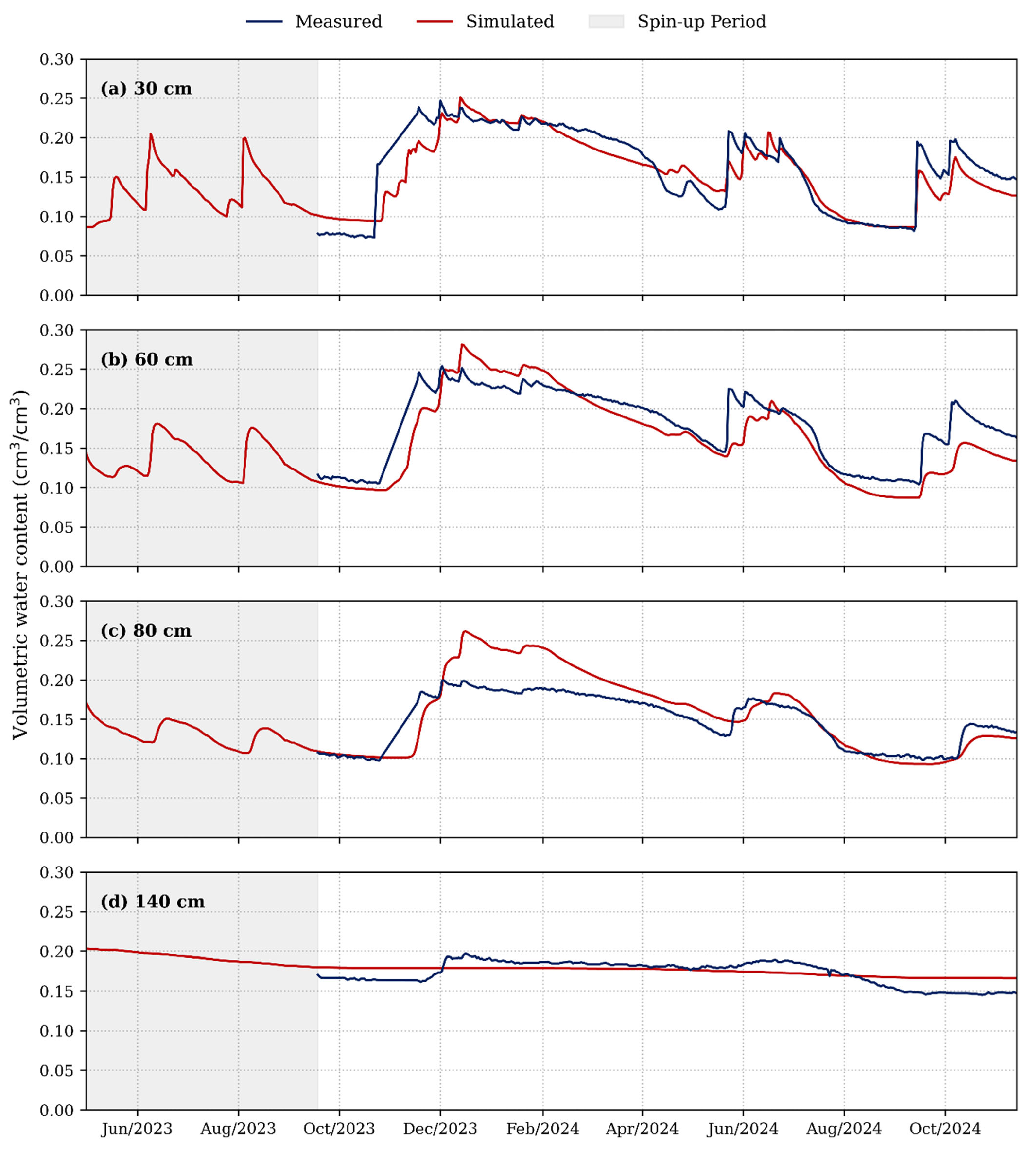
The results show that observed and simulated values are closely related, a finding supported by excellent goodness-of-fit metrics, including an NSE of 0.705 and a low RMSE of 0.021 cm3/cm3 (Figure 2). However, when observing the response to individual storm events, it is evident that the model tends to slightly underestimate measured moisture content within the shallow 30 cm and 60 cm horizons during peak infiltration phases. Conversely, during extended dry spells, an opposite trend emerges where HYDRUS tends to overestimate the retained moisture content in the deeper soil horizons. Preferential flow via decayed roots in shallow layers can increase soil water infiltration and supply [29]. Similarly, rainfall events can be pulsed or episodic, contrary to the slow-drip simulation by HYDRUS-1D in the daily time step [29].

3.2. Long-Term Infiltration Performance and Inter-Scenario Balances

Different simulation scenarios were evaluated to determine the long-term effectiveness of the infiltration pond, as shown in Table 2. Baseline scenarios (S0) yielded minimal deep percolation across all input datasets: 0.49 mm for local HMS data (2017–2023), 0.65 mm for FORESEE gridded data (2017–2023), and 18.06 mm for the long-term FORESEE data (1991–2023). These negligible percolation rates indicate that without decentralised intervention, nearly all input precipitation is partitioned between evapotranspiration, runoff, and shallow soil moisture storage, with minimal water bypassing the vadose zone.
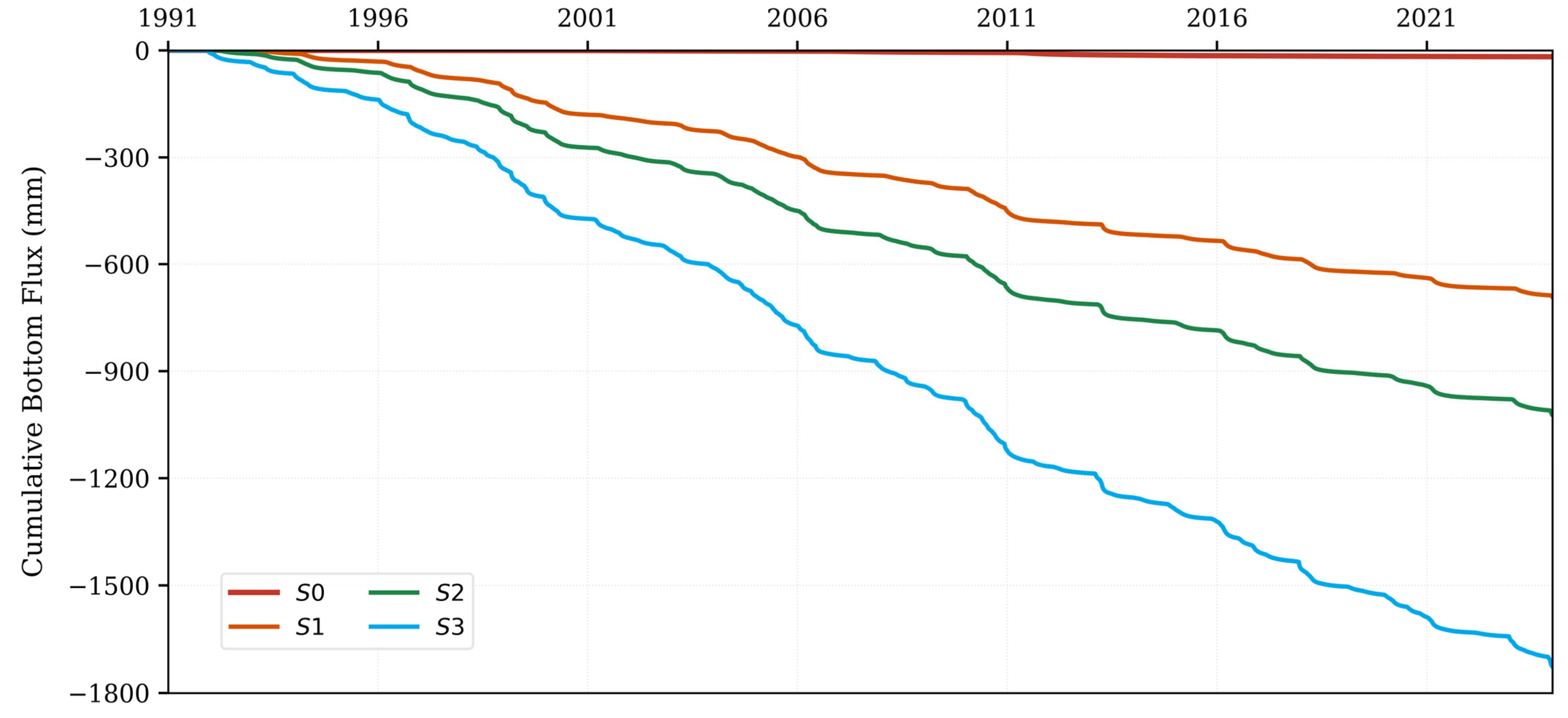
On the other hand, introducing the decentralised infiltration pond increased downward vertical drainage fluxes. Under the 1991–2023 historical gridded data, the S3 scenario resulted in 1730.98 mm of cumulative bottom flux (CBF), representing a significant increase over the baseline (Table 2, Figure A5). The cumulative fluxes for S1 and S2 were 692.56 mm and 1023.53 mm, respectively. This finding shows that smaller pond designs concentrate inflow and provide less surface area for evaporative losses, thereby driving greater vertical drainage per unit area.
The ET/PET ratio compares ET to PET and indicates the degree to which atmospheric water demand is being met and ecosystem water availability, with values below 1 indicating water stress [44]. The results show that the ET/PET ratio increased with pond implementation across all climate projections, suggesting improved water availability for urban vegetation (Table 2). Current climate baselines demonstrated an ET/PET of 0.53–0.57, whereas S3 scenarios reached 0.67–0.71, a mean increase of 0.14. Under the driest climate projection (HadGEM2_CCLM RCP8.5), ET/PET improved from 0.47 (S0) to 0.63 (S3), effectively restoring evaporative demand fulfilment to near-baseline levels (Table 2).
Average root zone saturation increased significantly from 33–40% in baseline scenarios to 58–64% in S3 scenarios across all climate models. This increase indicates that surface infiltration ponds substantially enhance soil moisture storage, thereby reducing localised moisture deficits and strengthening urban vegetation resilience. Complete mitigation of surface stormwater runoff was achieved across all simulated scenarios without any overspilling, indicating that the soil column has adequate capacity to route incoming storm volumes under the designated scoping designs safely.
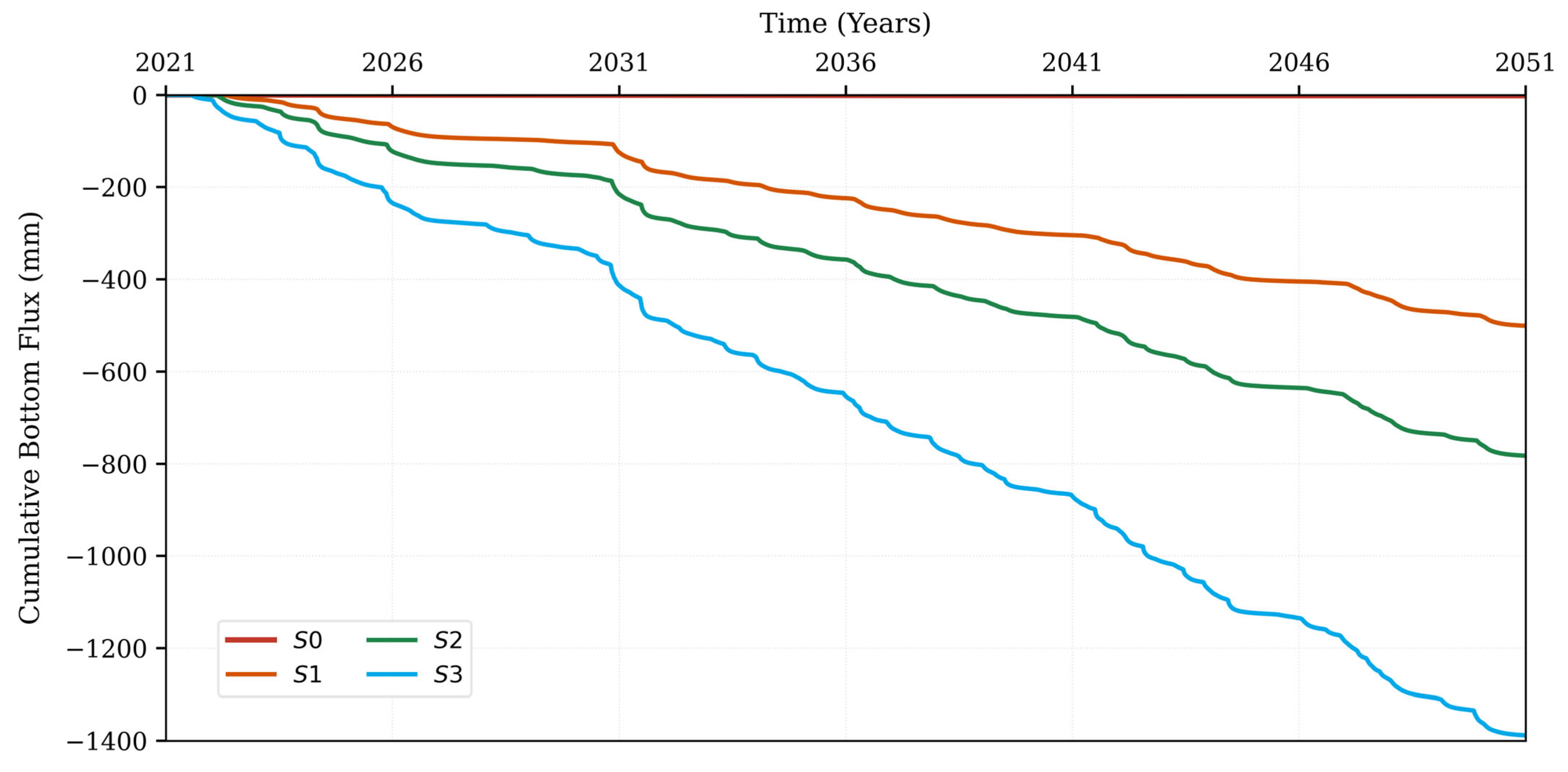
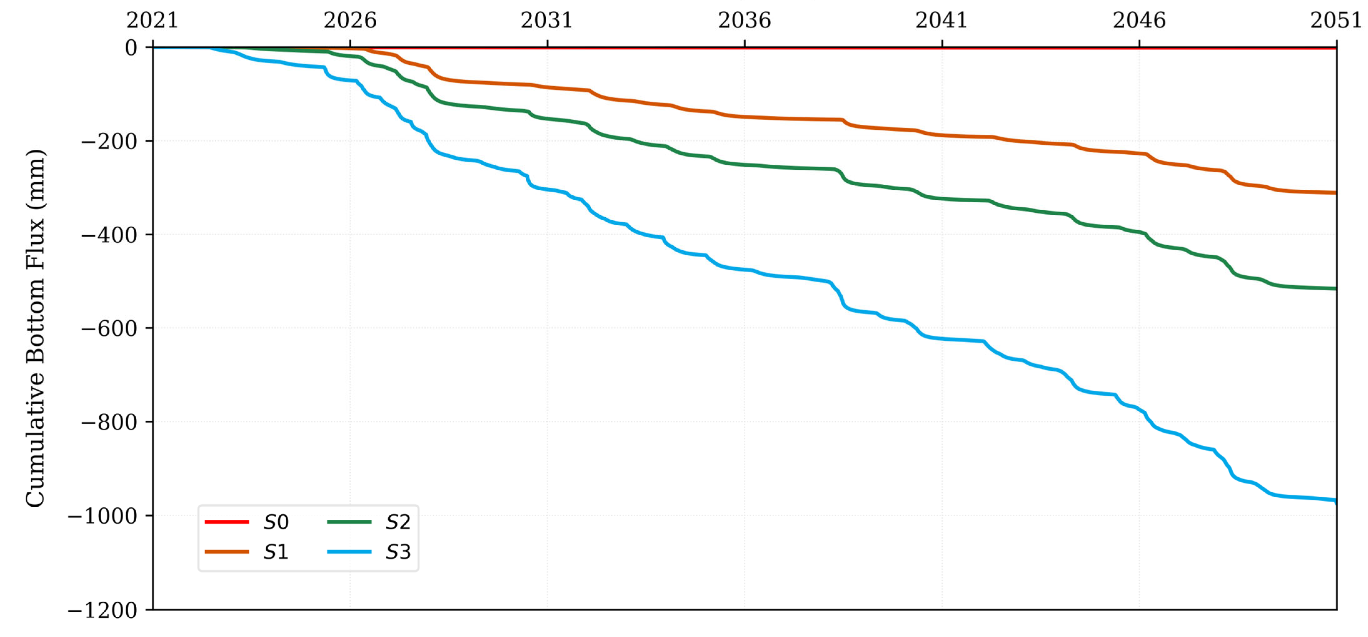
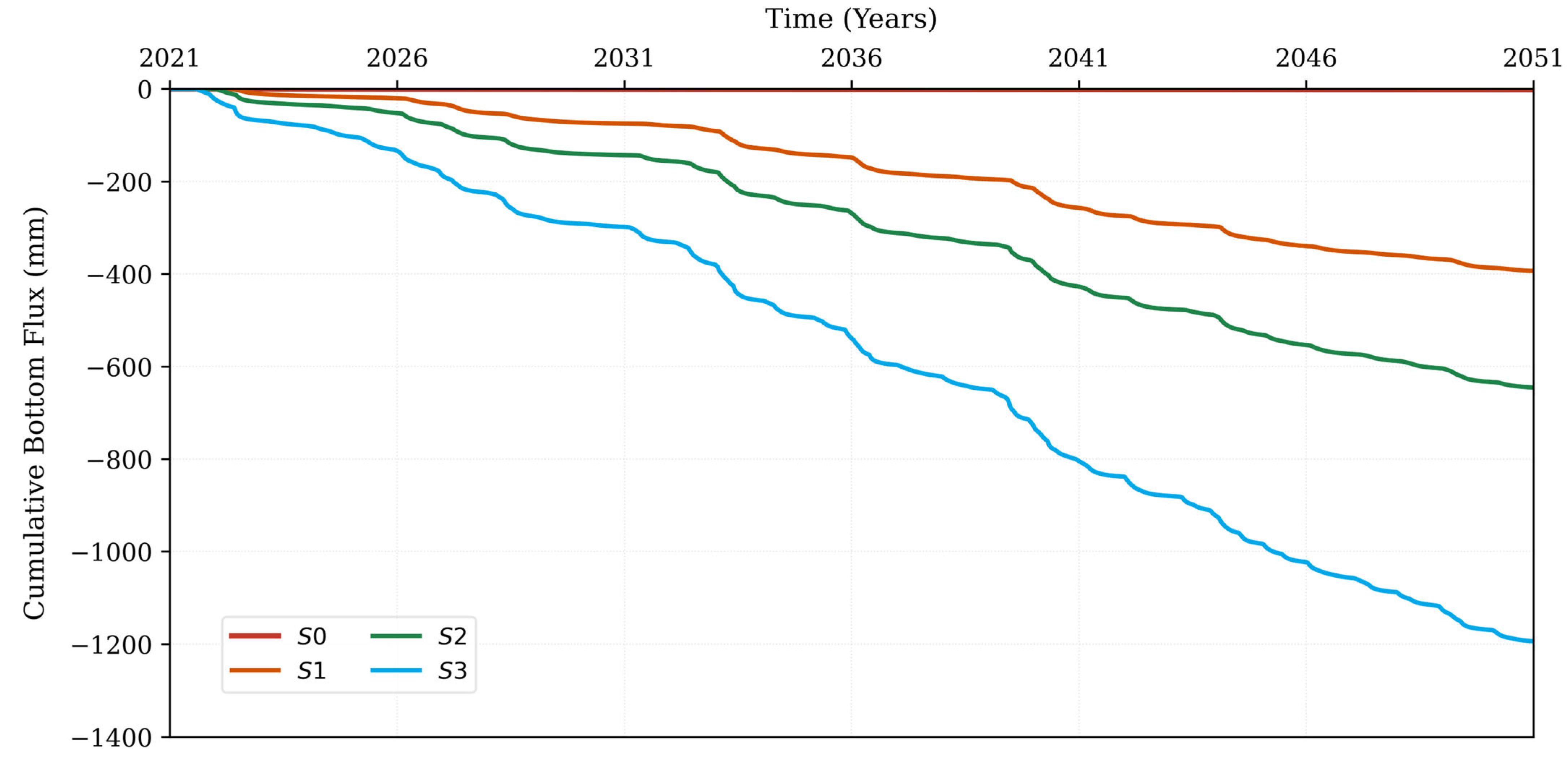
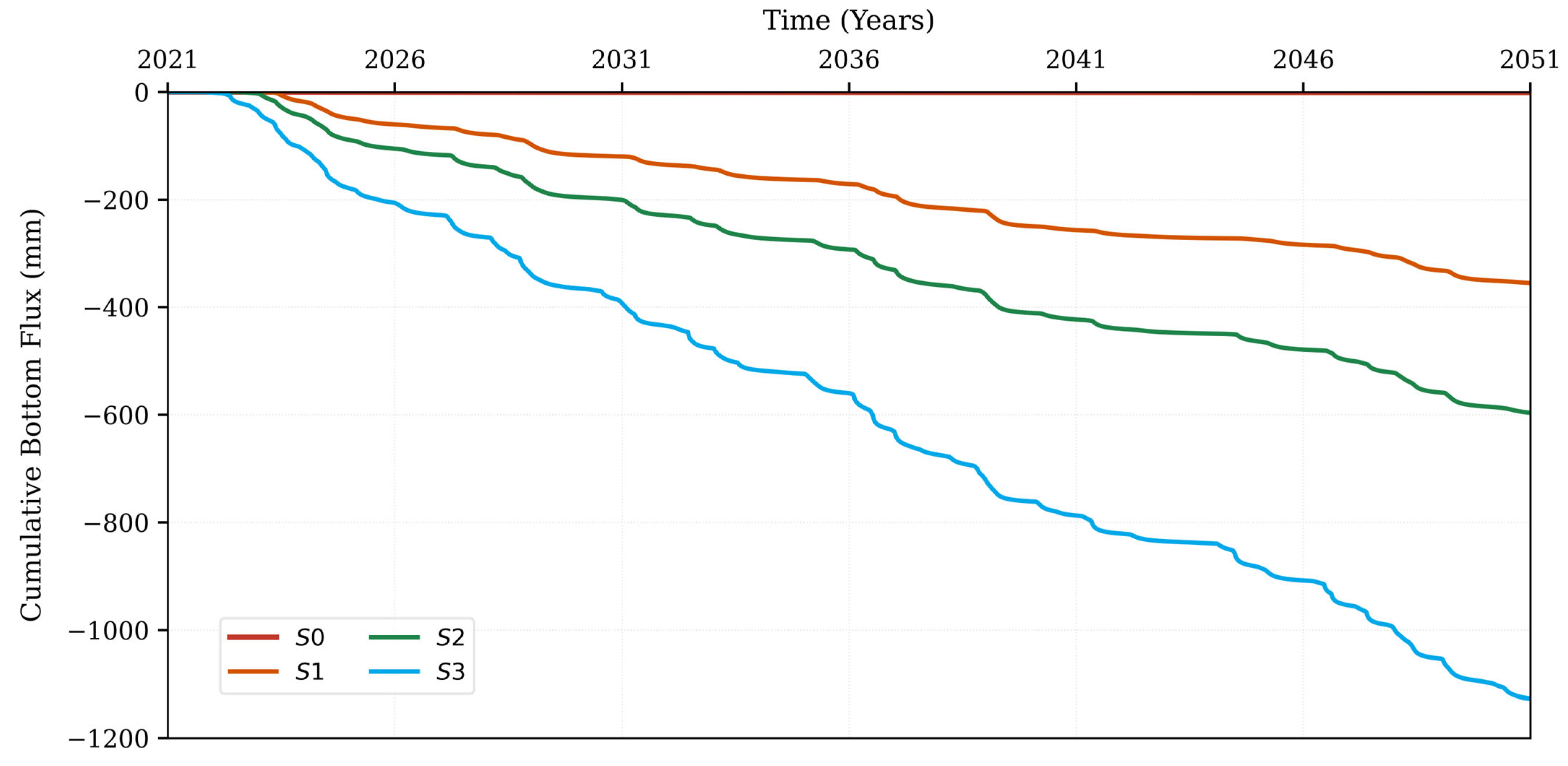
Across all simulated climate scenarios, the S0 baseline produced negligible CBF, remaining near the zero-flux axis throughout the 2021–2050 period. This shows that projected climate variability alone is not enough to drive significant vadose zone percolation in the absence of intervention. Simulation of the infiltration pond fundamentally altered this response. Under the pessimistic HadGEM2_CCLM_RCP8.5 scenario, S3 produced the highest cumulative bottom flux (~−1000 mm), followed by S2 (~−520 mm) and S1 (~−320 mm), with the hierarchical ordering of pond designs remaining stable throughout the simulation period (Figure 3). The step-like morphology of the S3 trajectory reflects the episodic character of deep percolation, driven by discrete high-intensity events rather than continuous seasonal drainage.
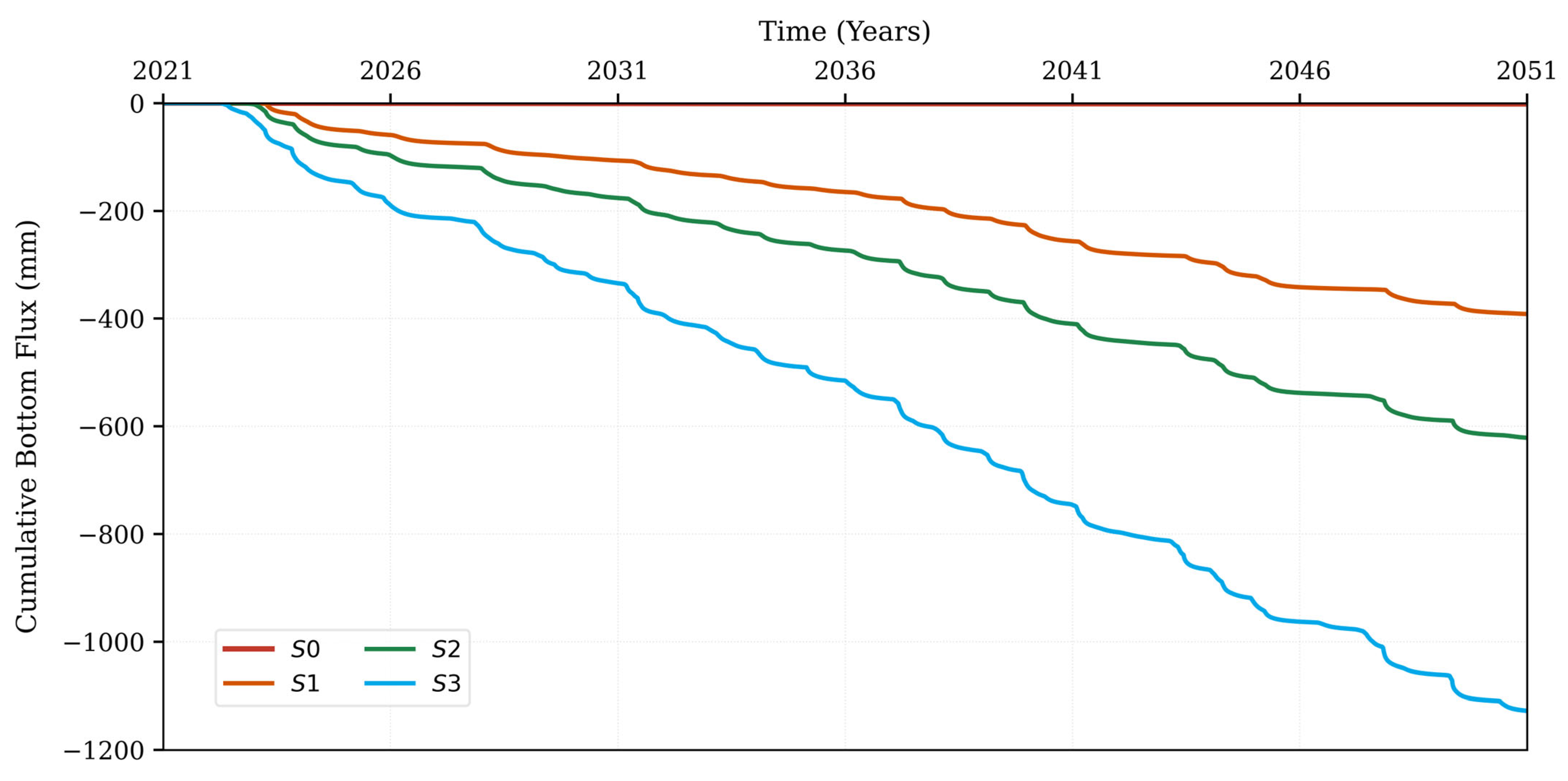
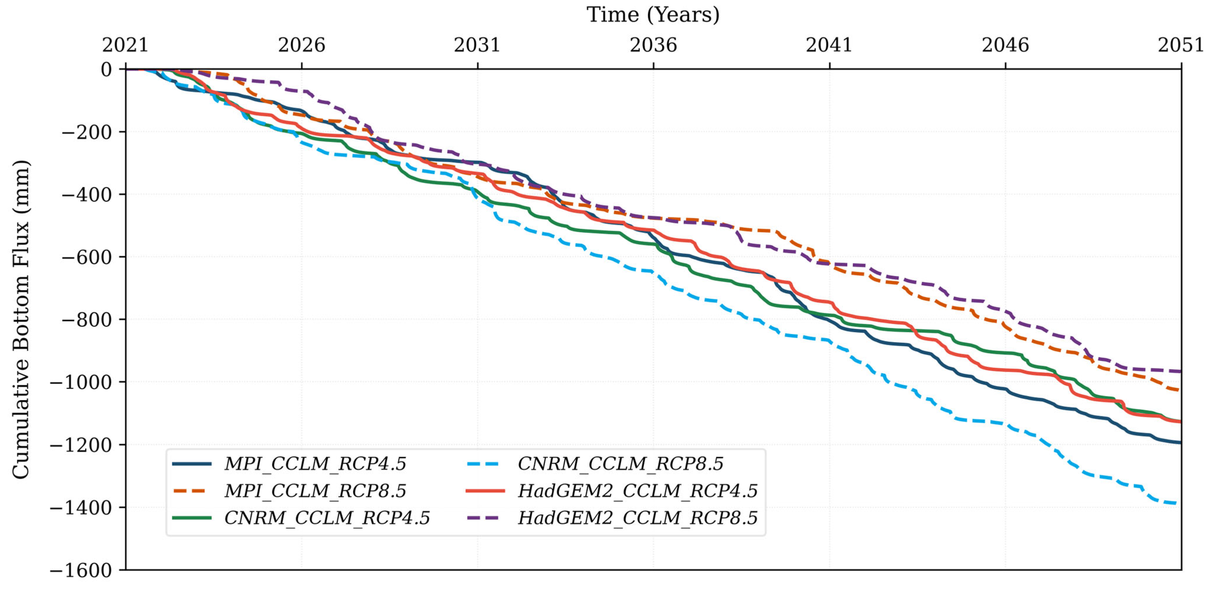
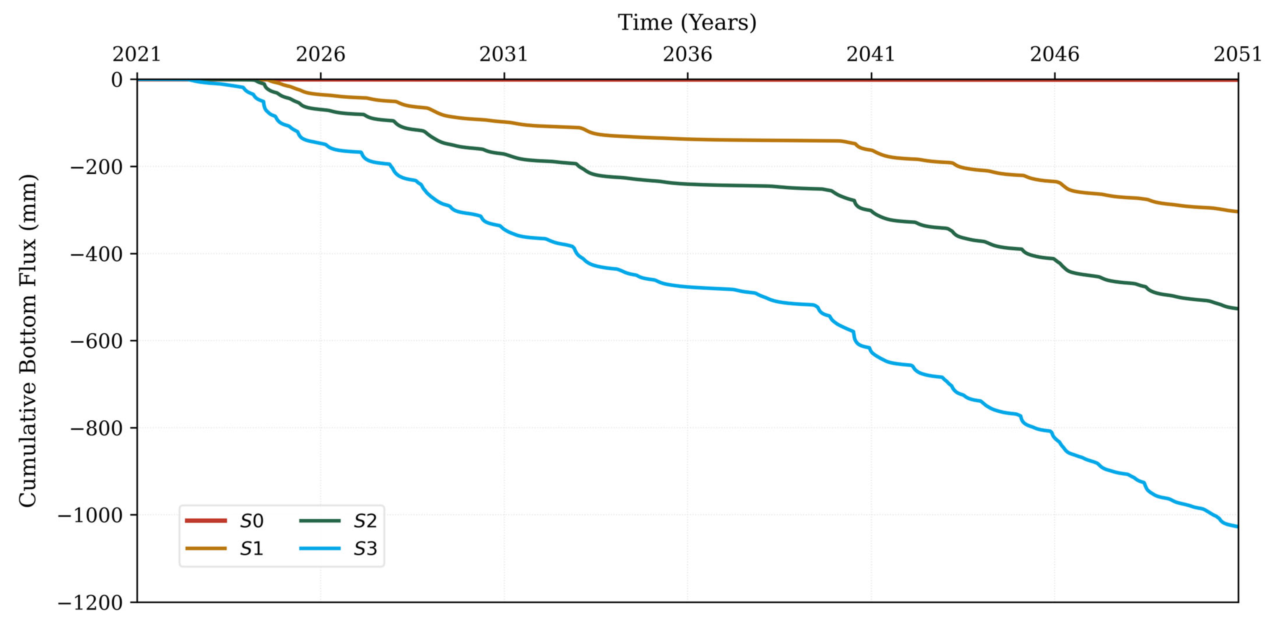
Evaluation of S3 across the selected climate models yielded sustained negative fluxes under all six climate combinations, ranging from approximately −1000 mm (HadGEM2_CCLM_RCP8.5 and MPI_CCLM_RCP8.5) to −1400 mm (CNRM_CCLM_RCP8.5) by 2050, demonstrating that pond performance is effective across the range of projected hydroclimatic conditions (Figure 4). Under the minimum warming trajectory (MPI_CCLM), RCP4.5 produced marginally greater cumulative flux than RCP8.5, suggesting that elevated evaporative demand under higher emissions partially offsets infiltration gains (Figure A6 and Figure A7). On the contrary, CNRM_CCLM exhibited greater CBF values under RCP8.5 than RCP4.5, consistent with more intense and temporally concentrated precipitation events driving higher hydraulic loading under the moderate warming pathway (Figure A8 and Figure A9).
All the intervention scenarios are well below the S0 baseline (Figure 3) across the full RCM ensemble, providing quantitative evidence that climate-driven precipitation shifts alone will not compensate for the absence of managed retention infrastructure. The results show that decentralised infiltration ponds, also known as NSWRM, have the potential to enhance subsoil aquifer recharge across different projected hydroclimatic conditions. Therefore, supporting their role as adaptive water management interventions under climate change.

4. Discussion

The overall satisfactory performance of the model (NSE = 0.705; RMSE = 0.021 cm3/cm3) aligns with the existing literature supporting the fact that Hydrus-1D provides reliable simulations of vertical moisture transport in layered soil environments when the vadose zone is accurately parameterised [31,33,36,39,45,46,47,48,49,50,51]. Observed systematic deviations, particularly the underestimation of soil water content (SWC) in shallow horizons during peak infiltration and the overestimation at depth during extended dry periods, are consistent with preferential flow dynamics through macropores and the inherent limitations of resolving episodic precipitation events at a daily time step [29,52,53].
The main hydraulic parameters, including saturated hydraulic conductivity, residual and saturated water contents, and van Genuchten curve-fitting constants, primarily drive these simulation sensitivities [31,54,55]. Inaccurate parameterisation of these variables is known to introduce systematic biases in gravity-dominated, deeper flow regimes; however, using in situ TDT sensor data for calibration helped minimise this uncertainty by grounding the model in observed transient soil moisture dynamics. Furthermore, the progressive decoupling of surface and deep SWC over time reflects the contrasting dominance of rapid atmospheric forcing at the soil–atmosphere boundary and restricted capillary flow within the deeper horizons [53]. This pattern reinforces the importance of using site-specific field data to capture the complex rewetting and drying cycles that define urban infiltration systems.
The use of high-resolution, sensor-calibrated data in this study ensures that the simulated vertical moisture flux is grounded in verified local conditions, providing a robust baseline that avoids the random and systematic errors often found in regional simulations [56]. Characterising soil hydraulic properties across broad landscapes is difficult and expensive, as saturated hydraulic conductivity is known to be overly spatially variable [26,56]. Studies in similar environments indicate that while site-specific, optimised parameters are highly representative within an immediate footprint of approximately 25 m [57], soil hydraulic properties can fluctuate by more than an order of magnitude across short distances due to variations in topography and depth [27,28].
The results show that decentralised infiltration ponds, functioning as natural/small water retention measures (NSWRMs), provide a dual-purpose hydrologic mechanism: the complete attenuation of surface stormwater runoff and the restoration of vertical percolation to support localised water balances. These findings directly corroborate prior research demonstrating that strategic water retention interventions effectively enhance groundwater recharge, increase irrigation water availability, and preserve downstream baseflow regimes in areas where urbanisation has historically disrupted the natural hydrologic cycle [17,18,19,21,22,58,59,60].
The negligible deep percolation (≤1.75 mm) observed in the S0 baseline across all climate scenarios corroborates the well-documented urban stream syndrome where land sealing and soil compaction fundamentally disrupt natural infiltration and groundwater recharge. These results align with findings by [17,29], who emphasise that traditional urban surfaces prioritise rapid runoff conveyance over vertical moisture flux, effectively decoupling the surface from the vadose zone.
The substantial increase in cumulative bottom flux (CBF) achieved by the S3 configuration, which reaches 1730 mm historically and maintains up to 1388 mm under future projections, demonstrates the high efficiency of infiltration-based intervention in restoring vertical hydrologic connectivity [38,60]. Interestingly, S3’s superior performance relative to larger pond areas suggests a threshold in the catchment-to-pond area ratio; larger ponds may face diminishing returns or increased evaporative losses without corresponding gains in infiltration capacity. This pattern is consistent with the literature, suggesting that decentralised, smaller-scale infiltration units can be more effective than centralised, oversized basins in maintaining moisture balances [60].
The observed improvements in the ET/PET ratio (0.63–0.71) and root zone saturation (58–64%) for S3 identify these ponds as critical components for urban heat island mitigation through evaporative cooling [61,62,63,64]. This shift toward a more natural water balance corroborates the regional findings [21,31] regarding the importance of soil moisture for urban vegetation health in Debrecen. Furthermore, by restoring vertical percolation in the Nyírség region, the S3 pond serves as the critical local water retention measure proposed by [21] to mitigate regional water table decline and protect the area’s climate-vulnerable groundwater-dependent ecosystems. Therefore, runoff attenuation achieved in all pond scenarios confirms that these systems provide effective flood protection even under mid-century climate stressors.
The emission pathway sensitivity pattern, where MPI_CCLM showed RCP4.5 CBF values greater than RCP8.5 CBF, while CNRM_CCLM showed the reverse, can be attributed to the dynamic balance between projected precipitation intensity and actual evaporation. In the MPI_CCLM model, the RCP8.5 scenario likely projects temperature increases that drive actual evaporation high enough to offset precipitation gains, thereby reducing net infiltration compared to the more moderate RCP4.5 [38]. Conversely, CNRM_CCLM under RCP8.5 likely predicts extreme precipitation intensities that override the increase in evaporative demand, leading to higher CBF.
This emission pathway sensitivity aligns with the projections of Staccione et al. (2021), who identified high variability in retention pond performance depending on the specific combination of climate scenarios used [22]. Furthermore, as noted by Jonoski et al. (2025), the hydrologic effectiveness of such nature-based measures is highly dependent on climate model scenarios, specifically how they represent the trade-off between short-duration, high-intensity events that drive infiltration and long-term temperature trends that escalate evaporative losses [18].
While our findings corroborate the general benefits of infiltration-based interventions identified by Baird et al. (2020), they diverge from some of the literature regarding the limitations of high-water tables; our results suggest that, provided the vadose zone is sufficiently thick (as in the Debrecen site), horizontal groundwater flow can actually enhance infiltration rates during peak stages [19]. The research has also shown that the S3 configuration provides a resilient solution for Debrecen, effectively bridging the gap between flood attenuation and groundwater replenishment under a range of future emission pathways.

5. Conclusions

This research provides a robust numerical evaluation of the potential for decentralised infiltration ponds to mitigate the urban stream syndrome and restore natural hydrologic cycles in regional recharge zones. The results of this investigation show that the S3 configuration (500 m2) provides a highly efficient dual functional mechanism: the complete attenuation of surface stormwater runoff and the substantial restoration of vertical percolation to support localised water balances. By increasing cumulative bottom flux by over 1000 mm compared to the baseline, these ponds function as critical natural or small water retention measures capable of enhancing groundwater recharge in the climate-vulnerable Nyírség region.
The study highlights that the hydrologic effectiveness of such interventions is highly sensitive to the specific climate model representation of the trade-off between short-duration, high-intensity precipitation and long-term temperature-driven evaporative losses. Despite this, the proposed infiltration ponds remained effective in providing both flood protection and soil moisture content (58–64% saturation), which is essential for sustaining urban vegetation health and mitigating heat island effects.
While this study employs a process-driven Hydrus-1D model to simulate vertical moisture flux, advanced modelling in geohydrological engineering has increasingly utilised order-reduction techniques, such as coupled models and the truncated spectral method, to analyse the non-linear stability and bifurcation behaviour of subsurface seepage systems under critical conditions [24]. Implementing such low-dimensional modelling frameworks in future work would allow for a more efficient quantitative extraction of critical instability parameters, helping to identify tipping points where infiltration systems may lose stability under extreme hydraulic loading [24]. Additionally, future investigations should consider the long-term evolution of subsurface hydraulic properties resulting from cumulative environmental stress. Research into other geomaterials indicates that extreme environmental cycling such as the high-temperature and intense precipitation swings projected in RCP 8.5 scenarios can induce cumulative structural damage, fundamentally altering porosity and permeability over time [25]. Understanding how these stressors induce micropores, preferential flow, and evolve fluid migration pathways will be essential for assessing the multi-decadal performance and structural integrity of decentralised retention infrastructure.
A limitation of the present modelling approach is the reliance on the 15-month continuous sensor dataset for model calibration without an independent validation period, constrained by the temporal availability of high-resolution field monitoring records. Using the available dataset for calibration ensured that the model effectively captured seasonal rewetting and drying cycles across all monitored depths; the absence of a separate validation phase means long-term simulations under projected RCM climate storylines should be interpreted as comparative scoping evaluations rather than exact deterministic forecasts.
To build upon these scoping findings, future work should prioritise: (1) constructing physical pilot-scale infiltration ponds equipped with multi-depth soil sensor networks and infiltrometers to perform empirical field validation under actual operational conditions; (2) incorporating dynamic clogging modules and open-water surface evaporation into multi-dimensional hydrological models such as HYDRUS-2D/3D or SWMM-HYDRUS coupling; (3) testing the transferability of this decentralised pond framework across diverse urban geomorphologies with shallow water tables or lower-permeability clay soils; and (4) integrating 3D landscape-scale soil hydraulic maps to assess parameter uncertainty propagation across broader urban catchments. Addressing these perspectives will advance the practical implementation of natural water retention measures for urban climate adaptation.
The findings of the current study are site-specific to Debrecen; however, they support the regional and international literature advocating for managed aquifer recharge as a primary adaptation strategy for water-scarce urban environments. We conclude that the strategic implementation and scaling of these decentralised infiltration ponds offer a resilient solution for flood mitigation, securing urban water assets, and replenishing depleted regional aquifers under a range of future emission pathways. In addition, to strengthen future regional upscaling of these decentralised interventions, scaling techniques can be applied to compare local findings with heterogeneous porous media. Integrating our results with high-resolution gridded hydraulic maps (e.g., 100-m resolution) would further allow the uncertainties propagated by this inherent landscape-scale soil variability to be quantified.

Author Contributions

Conceptualisation, N.P.M. and Z.K.; methodology, N.P.M. and Z.K.; software, N.P.M., B.D. and Z.K.; validation, N.P.M., A.M., and T.M.; formal analysis, N.P.M.; investigation, N.P.M. and Z.K.; data curation, all authors.; writing—original draft preparation, N.P.M.; writing—review and editing, all authors; visualization, N.P.M., B.D. and Z.K.; supervision, Z.K.; project administration, Z.K.; funding acquisition, Z.K. All authors have read and agreed to the published version of the manuscript.

Funding

The research presented in the article was carried out within the framework of the Széchenyi Plan Plus program with the support of the RRF 2.3.1 21 2022 00008 project.

Data Availability Statement

The historical meteorological records and simulated soil moisture datasets generated during the current study are available from the corresponding author upon reasonable academic request. Gridded climatic projections were sourced directly from the public FORESEE database (Historical Meteorological Records: https://odp.met.hu/climate/observations_hungary/daily/historical/, FORESEE Database: https://meteordata.elte.hu/FORESEE/index.html and https://meteordata.elte.hu/FORESEE/DATA/, accessed on 13 August 2026).

Acknowledgments

The authors would like to express their sincere gratitude to Gyöngyi Barna for her invaluable contribution and to Tamás Ács for providing the technical support for the double ring infiltrometer field measurements.

Conflicts of Interest

The authors declare no conflicts of interest. The funding structures had no role in the design of the study; in the collection, analyses, or interpretation of the data; in the writing of the manuscript; or in the decision to publish the results.

Appendix A

Figure A1. Location of reference soil profile (Profile A), the HMS meteorological station (ID: 64711), and the proposed infiltration pond (blue circle on the map) and buildings in Debrecen. The inset map shows the scanned rooftop catchment in red ( 695   m 2 ) and the proposed infiltration pond location near the building.
Water 18 02006 g0a1
Figure A2. Reference soil profile at the University of Debrecen Campus: photo of the profile showing the soil horizons (left) and the numerical representation of the hydraulic properties applied in the Hydrus-1D model (right).
Water 18 02006 g0a2
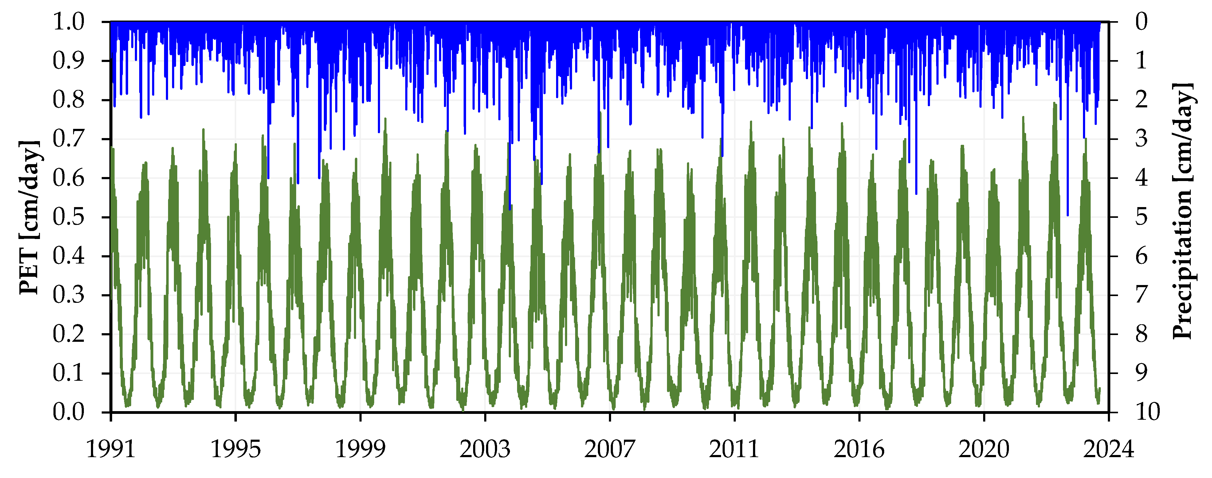
Figure A3. Daily Precipitation (Blue) and Potential Evapotranspiration (Green) from FORESEE Gridded Climate Data (1991–2023).
Water 18 02006 g0a3
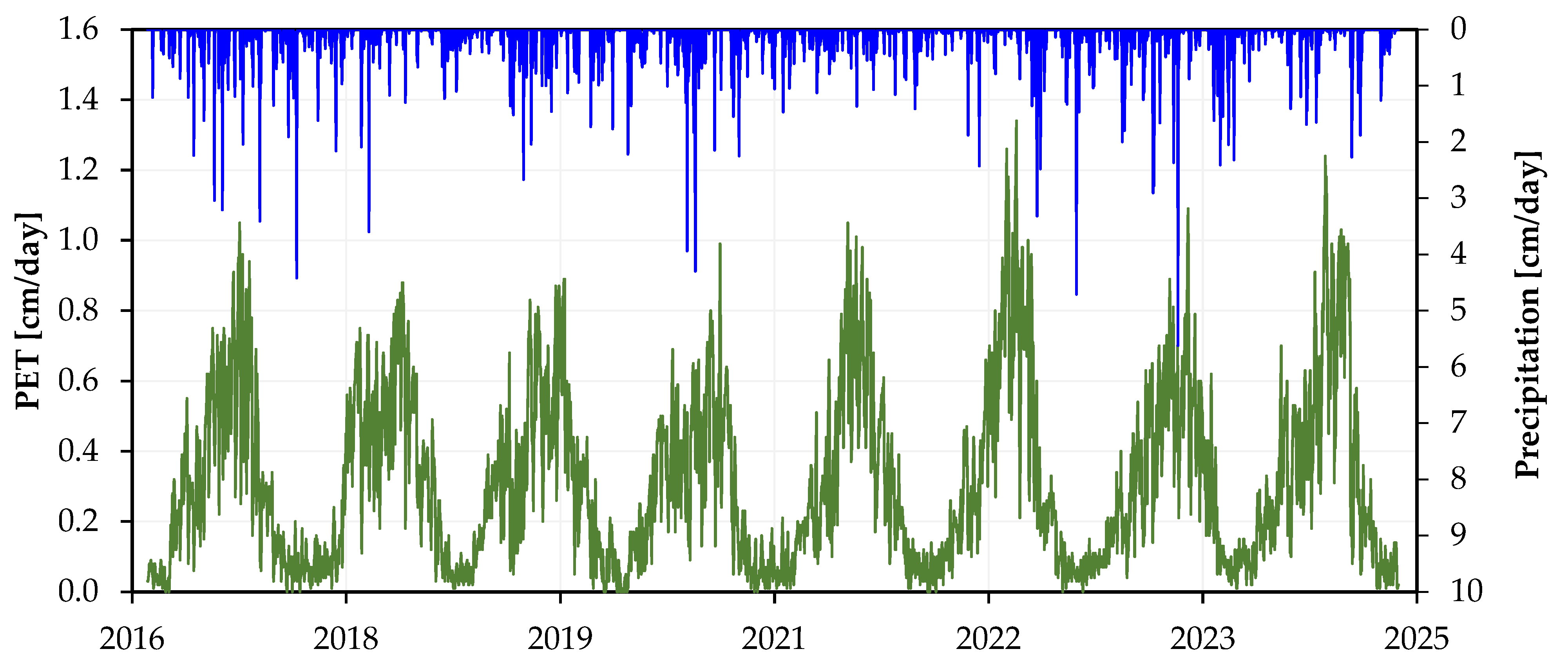
Figure A4. Daily Precipitation (Blue) and Potential Evapotranspiration (Green) from HMS Station Observations (2017–2023).
Water 18 02006 g0a4
Figure A5. Simulated cumulative bottom flux under observed climate data (1991–2023) for four infiltration pond designs (S0–S3).
Water 18 02006 g0a5
Figure A6. Cumulative bottom flux for infiltration pond scenarios S0–S3 under MPI_CCLM_RCP4.5 projected climate conditions (2021–2050).
Water 18 02006 g0a6
Figure A7. Cumulative bottom flux for infiltration pond scenarios S0–S3 under MPI_CCLM_RCP8.5 projected climate conditions (2021–2050).
Water 18 02006 g0a7
Figure A8. Cumulative bottom flux for infiltration pond designs S0–S3 under CNRM_CCLM_RCP4.5 mid-range climate projection (2021–2050).
Water 18 02006 g0a8
Figure A9. Influence of pond size on simulated bottom flux under the CNRM_CCLM_RCP8.5 emissions scenario (2021–2050).
Water 18 02006 g0a9
Figure A10. Cumulative bottom flux for infiltration pond scenarios S0–S3 under HadGEM2_RCP4.5 projected climate conditions (2021–2050).
Water 18 02006 g0a10

References

  1. Na, W.; Najafi, M.R. Rising Risks of Hydroclimatic Swings: A Large Ensemble Study of Dry and Wet Spell Transitions in North America. Glob. Planet. Change 2024, 238, 104476. [Google Scholar] [CrossRef] [Scilit]
  2. Cheng, C.; Yang, Y.C.E.; Ryan, R.; Yu, Q.; Brabec, E. Assessing Climate Change-Induced Flooding Mitigation for Adaptation in Boston’s Charles River Watershed, USA. Landsc. Urban Plan. 2017, 167, 25–36. [Google Scholar] [CrossRef] [Scilit]
  3. Huong, H.T.L.; Pathirana, A. Urbanisation and Climate Change Impacts on Future Urban Flooding in Can Tho City, Vietnam. Hydrol. Earth Syst. Sci. 2013, 17, 379–394. [Google Scholar] [CrossRef] [Scilit]
  4. Adelekan, I.O. Vulnerability of Poor Urban Coastal Communities to Flooding in Lagos, Nigeria. Environ. Urban. 2010, 22, 433–450. [Google Scholar] [CrossRef] [Scilit]
  5. Hallegatte, S. Strategies to Adapt to an Uncertain Climate Change. Glob. Environ. Change 2009, 19, 240–247. [Google Scholar] [CrossRef] [Scilit]
  6. Chen, W.; Wang, W.; Huang, G.; Wang, Z.; Lai, C.; Yang, Z. The Capacity of Grey Infrastructure in Urban Flood Management: A Comprehensive Analysis of Grey Infrastructure and the Green-Grey Approach. Int. J. Disaster Risk Reduct. 2021, 54, 102045. [Google Scholar] [CrossRef] [Scilit]
  7. Nowakowska, M.; Wartalska, K.; Kaźmierczak, B.; Kotowski, A. Verification of the Stormwater Drainage System Overloads in Wrocław for an Assessment of Climate Change Effects. Period. Polytech. Civ. Eng. 2019, 63, 641–646. [Google Scholar] [CrossRef] [Scilit]
  8. Kálmán, A.; Bene, K. Optimised Implementation of Nature-Based Solutions for Sustainable Economic Benefits in a Watershed with Water Deficit—A Case Study in Hilly Settlements of Lake Velence. Chem. Eng. Trans. 2023, 107, 265–270. [Google Scholar] [CrossRef]
  9. Bihari, Z.; Babolcsai, G.; Bartholy, J.; Ferenczi, Z.; Kerényi, G.J.; Haszpra, L.; Homoki-Ujváry, K.; Kovács, T.; Lakatos, M.; Németh, Á.; et al. National Atlas of Hungary—Natural Environment. In National Atlas of Hungary—Natural Environment; Bihari, Z., Ed.; MTA CSFK Geographical Institute: Budapest, Hungary, 2018; Volume 2. [Google Scholar]
  10. Allan, R.P. Dichotomy of Drought and Deluge. Nat. Geosci. 2014, 7, 700–701. [Google Scholar] [CrossRef] [Scilit]
  11. European Commission. Green Infrastructure (GI)—Enhancing Europe’s Natural Capital; European Commission: Brussels, Belgium, 2013. [Google Scholar]
  12. European Commission. A Blueprint to Safeguard Europe’s Water Resources; European Commission: Brussels, Belgium, 2012. [Google Scholar]
  13. European Commission. European Water Resilience Strategy; COM (2025) 280 final; European Commission: Brussels, Belgium, 2025. [Google Scholar]
  14. General Directorate of Water Management. Nemzeti Vízstratégia—Kvassay Jenő Terv; General Directorate of Water Management: Budapest, Hungary, 2017. [Google Scholar]
  15. Magnier, J.; Fribourg-Blanc, B.; Lemann, T.; Witing, F.; Critchley, W.; Volk, M. Natural/Small Water Retention Measures: Their Contribution to Ecosystem-Based Concepts. Sustainability 2024, 16, 1308. [Google Scholar] [CrossRef] [Scilit]
  16. Ruangpan, L.; Vojinovic, Z.; Di Sabatino, S.; Leo, L.S.; Capobianco, V.; Oen, A.M.P.; McClain, M.E.; Lopez-Gunn, E. Nature-Based Solutions for Hydro-Meteorological Risk Reduction: A State-of-the-Art Review of the Research Area. Nat. Hazards Earth Syst. Sci. 2020, 20, 243–270. [Google Scholar] [CrossRef] [Scilit]
  17. Zhang, K.; Chui, T.F.M. A Review on Implementing Infiltration-Based Green Infrastructure in Shallow Groundwater Environments: Challenges, Approaches, and Progress. J. Hydrol. 2019, 579, 124089. [Google Scholar] [CrossRef] [Scilit]
  18. Jonoski, A.; Ali, M.H.; Bertini, C.; Popescu, I.; van Andel, S.J.; Lansu, A. Model-Based Design of Drought-Related Climate Adaptation Strategies Using Nature-Based Solutions: Case Study of the Aa of Weerijs Catchment in the Netherlands. Nat.-Based Solut. 2025, 8, 100264. [Google Scholar] [CrossRef] [Scilit]
  19. Baird, J.B.; Winston, R.J.; Hunt, W.F. Evaluating the Hydrologic and Water Quality Performance of Novel Infiltrating Wet Retention Ponds. Blue-Green Syst. 2020, 2, 282–299. [Google Scholar] [CrossRef] [Scilit]
  20. Kiedrzyńska, E.; Belka, K.; Jarosiewicz, P.; Kiedrzyński, M.; Zalewski, M. The Enhancement of Valley Water Retentiveness in Climate Change Conditions. Sci. Total Environ. 2021, 799, 149427. [Google Scholar] [CrossRef] [Scilit] [PubMed]
  21. Simon, S.; Déri-Takács, J.; Szijártó, M.; Szél, L.; Mádl-Szőnyi, J. Wetland Management in Recharge Regions of Regional Groundwater Flow Systems with Water Shortage, Nyírség Region, Hungary. Water 2023, 15, 3589. [Google Scholar] [CrossRef] [Scilit]
  22. Staccione, A.; Broccoli, D.; Mazzoli, P.; Bagli, S.; Mysiak, J. Natural Water Retention Ponds for Water Management in Agriculture: A Potential Scenario in Northern Italy. J. Environ. Manag. 2021, 292, 112849. [Google Scholar] [CrossRef] [Scilit] [PubMed]
  23. Chang, K.-H.; Hsu, Y.-N.; Li, H.-C. Optimising the Allocation of Flood Control Investments for Effective Disaster Risk Reduction. Comput. Ind. Eng. 2025, 210, 111536. [Google Scholar] [CrossRef] [Scilit]
  24. Cao, Z.; Miao, C.; Du, F.; Zhu, D.; Teng, T.; Xue, Y. A Bifurcation Dynamical Analysis of a Non-Darcy Seepage System in Post-Failure Rock Based on a Novel Truncated Spectral Method. Processes 2026, 14, 1468. [Google Scholar] [CrossRef] [Scilit]
  25. Xue, Y.; Wang, L.; Cai, Y.; Liu, J.; Ranjith, P.G.; Gao, F.; Xie, H.; Liu, Y. Effects of Heating–Cooling on the Mechanical Properties and Damage Evolution of Granite for Underground Cryogenic Storage. Acta Geotech. 2026, 21. [Google Scholar] [CrossRef] [Scilit]
  26. Soares, M.F.; Timm, L.C.; Siqueira, T.M.; dos Santos, R.C.V.; Reichardt, K. Assessing the Spatial Variability of Saturated Soil Hydraulic Conductivity at the Watershed Scale Using the Sequential Gaussian Co-Simulation Method. Catena 2023, 221, 106756. [Google Scholar] [CrossRef] [Scilit]
  27. Santini, A.; Coppola, A.; Romano, N.; Terribile, F. Interpretation of the Spatial Variability of Soil Hydraulic Properties Using a Land System Analysis. In Modelling of Transport Processes in Soils at Various Scales in Time and Space; Wageningen Pers: Wageningen, The Netherlands, 1999; pp. 491–500. [Google Scholar]
  28. Zhang, Y.; Wang, T.; Han, Q.; Zuo, Y.; Bai, Q.; Li, X. Spatial Variability in Soil Hydraulic Properties Under Different Vegetation Conditions in a Coastal Wetland. Land 2025, 14, 428. [Google Scholar] [CrossRef] [Scilit]
  29. Bai, X.; Jia, X.; Jia, Y.; Shao, M.; Hu, W. Modelling Long-Term Soil Water Dynamics in Response to Land-Use Change in a Semi-Arid Area. J. Hydrol. 2020, 585, 124824. [Google Scholar] [CrossRef] [Scilit]
  30. Brocca, L.; Ciabatta, L.; Massari, C.; Camici, S.; Tarpanelli, A. Soil Moisture for Hydrological Applications: Open Questions and New Opportunities. Water 2017, 9, 140. [Google Scholar] [CrossRef] [Scilit]
  31. Kozma, Z.; Decsi, B.; Ács, T.; Jolánkai, Z.; Manninger, M.; Móricz, N.; Illés, G.; Barna, G.; Makó, A.; Szabó, B. Functional Evaluation of Different Soil Hydraulic Parametrisations in Hydrological Simulations Reveals Different Model Efficiency for Soil Moisture and Water Budget. J. Hydrol. Hydromech. 2024, 72, 312–335. [Google Scholar] [CrossRef] [Scilit]
  32. Ket, P.; Oeurng, C.; Degré, A. Estimating Soil Water Retention Curve by Inverse Modelling from Combination of In Situ Dynamic Soil Water Content and Soil Potential Data. Soil Syst. 2018, 2, 55. [Google Scholar] [CrossRef] [Scilit]
  33. Kanzari, S.; Ben Nouna, B.; Ben Mariem, S.; Rezig, M. Hydrus-1D Model Calibration and Validation in Various Field Conditions for Simulating Water Flow and Salts Transport in a Semi-Arid Region of Tunisia. Sustain. Environ. Res. 2018, 28, 350–356. [Google Scholar] [CrossRef] [Scilit]
  34. Guizani, D.; Buday-Bódi, E.; Tamás, J.; Nagy, A. Enhancing Water Balance Assessment in Urban Areas through High-Resolution Land Cover Mapping: Case Study of Debrecen, Hungary. Environ. Chall. 2024, 15, 100906. [Google Scholar] [CrossRef] [Scilit]
  35. Šimůnek, J.; Brunetti, G.; Jacques, D.; van Genuchten, M.T.; Šejna, M. Developments and Applications of the HYDRUS Computer Software Packages Since 2016. Vadose Zone J. 2024, 23, e20310. [Google Scholar] [CrossRef] [Scilit]
  36. Gammon, C.L. HYDRUS-1D Modelling to Represent Hydrologic Performance of the Oncenter Green Roof. Master’s Thesis, Syracuse University, Syracuse, NY, USA, 2021. [Google Scholar]
  37. Bacchi, O.O.S.; Reichardt, K.; Libardi, P.L.; Moraes, S.O. Scaling of Soil Hydraulic Properties in the Evaluation of Hydraulic Conductivity Determination Methods. Soil Technol. 1989, 2, 163–170. [Google Scholar] [CrossRef] [Scilit]
  38. Guram, S.; Bashir, R. Designing Effective Low-Impact Developments for a Changing Climate: A HYDRUS-Based Vadose Zone Modelling Approach. Water 2024, 16, 1803. [Google Scholar] [CrossRef] [Scilit]
  39. Leterme, B.; Mallants, D.; Jacques, D. Sensitivity of Groundwater Recharge Using Climatic Analogues and HYDRUS-1D. Hydrol. Earth Syst. Sci. 2012, 16, 2485–2497. [Google Scholar] [CrossRef] [Scilit]
  40. Allen, R.G.; Pereira, L.S.; Raes, D.; Smith, M. Crop Evapotranspiration (Guidelines for Computing Crop Water Requirements); Food and Agriculture Organisation of the United Nations: Rome, Italy, 1998. [Google Scholar]
  41. Šimůnek, J.; Van Genuchten, M.T.; Šejna, M. The HYDRUS-1D Software Package for Simulating the One-Dimensional Movement of Water, Heat, and Multiple Solutes in Variably-Saturated Media; University of California: Oakland, CA, USA, 2018. [Google Scholar]
  42. Kern, A.; Dobor, L.; Hollós, R.; Marjanović, H.; Torma, C.Z.; Kis, A.; Fodor, N.; Barcza, Z. Seamlessly Combined Historical and Projected Daily Meteorological Datasets for Impact Studies in Central Europe: The FORESEE v4.0 and the FORESEE-HUN v1.0. Clim. Serv. 2024, 33, 100443. [Google Scholar] [CrossRef] [Scilit]
  43. Hargreaves, G.; Samani, Z. Reference Crop Evapotranspiration from Temperature. Appl. Eng. Agric. 1985, 1, 96–99. [Google Scholar] [CrossRef] [Scilit]
  44. Li, S.; Zhang, D.; Xing, Y.; Zhang, C.; Wang, Z.; Ma, R.; He, K.; Wang, P. Interannual Dynamics and Controlling Factors of the Ratio of Actual to Potential Evapotranspiration across Typical Ecosystems within the Heihe River Basin. Hydrol. Process. 2024, 38, e15073. [Google Scholar] [CrossRef] [Scilit]
  45. Turco, M.; Brusco, A.C.; Brunetti, G.; Piro, P. Coupling Hydrus-1D and EPA SWMM to Assess the Multiscale Hydrological Benefits of a Green Infrastructure. Water Resour. Manag. 2025, 39, 8249–8265. [Google Scholar] [CrossRef] [Scilit]
  46. Moghbel, F.; Mosaedi, A.; Aguilar, J.; Ghahraman, B.; Ansari, H.; Gonçalves, M.C. Uncertainty Analysis of HYDRUS-1D Model to Simulate Soil Salinity Dynamics under Saline Irrigation Water Conditions Using Markov Chain Monte Carlo Algorithm. Agronomy 2022, 12, 2793. [Google Scholar] [CrossRef] [Scilit]
  47. Šimůnek, J.; van Genuchten, M.T.; Šejna, M. Recent Developments and Applications of the HYDRUS Computer Software Packages. Vadose Zone J. 2016, 15, 1–25. [Google Scholar] [CrossRef] [Scilit]
  48. Xie, H.; Wu, Y.; Wang, L.; Luo, W.; Zhou, W.; Zhou, H.; Yan, Y.; Liu, J. Comparing Simulations of Green Roof Hydrological Processes by SWMM and HYDRUS-1D. Water Supply 2020, 20, 130–139. [Google Scholar] [CrossRef] [Scilit]
  49. Shelia, V.; Šimůnek, J.; Boote, K.; Hoogenboom, G. Coupling DSSAT and HYDRUS-1D for Simulations of Soil Water Dynamics in the Soil-Plant-Atmosphere System. J. Hydrol. Hydromech. 2018, 66, 232–245. [Google Scholar] [CrossRef] [Scilit]
  50. González, M.G.; Ramos, T.B.; Carlesso, R.; Paredes, P.; Petry, M.T.; Martins, J.D.; Aires, N.P.; Pereira, L.S. Modelling Soil Water Dynamics of Full and Deficit Drip Irrigated Maize Cultivated under a Rain Shelter. Biosyst. Eng. 2015, 132, 1–18. [Google Scholar] [CrossRef] [Scilit]
  51. Dong, X.; Qin, F.; Li, L.; Yang, Z.; Li, Y.; Wu, Y. Study on Water Vertical Infiltration Characteristics and Water Content Simulation of Sandstone Overlying Loess. Water 2022, 14, 3716. [Google Scholar] [CrossRef] [Scilit]
  52. Šimůnek, J.; Jarvis, N.J.; van Genuchten, M.T.; Gärdenäs, A. Review and Comparison of Models for Describing Non-Equilibrium and Preferential Flow and Transport in the Vadose Zone. J. Hydrol. 2003, 272, 14–35. [Google Scholar] [CrossRef] [Scilit]
  53. Krevh, V.; Groh, J.; Weihermüller, L.; Filipović, L.; Defterdarović, J.; Kovač, Z.; Magdić, I.; Lazarević, B.; Baumgartl, T.; Filipović, V. Investigation of Hillslope Vineyard Soil Water Dynamics Using Field Measurements and Numerical Modelling. Water 2023, 15, 820. [Google Scholar] [CrossRef] [Scilit]
  54. Engels, A.M.; Gaiser, T.; Ewert, F.; Grahmann, K.; Hernández-Ochoa, I. Simulating Soil Moisture Dynamics in a Diversified Cropping System Under Heterogeneous Soil Conditions. Agronomy 2025, 15, 407. [Google Scholar] [CrossRef] [Scilit]
  55. Sales, D.d.S.; Lugon Junior, J.; Costa, D.d.A.; Sales, R.S.B.; Neves, R.J.; Silva Neto, A.J.d. Sensitivity Analysis of Soil Hydraulic Parameters for Improved Flow Predictions in an Atlantic Forest Watershed Using the MOHID-Land Platform. Eng 2025, 6, 65. [Google Scholar] [CrossRef] [Scilit]
  56. Schaap, M.G.; Zhang, Y.; Rasmussen, C. Soil Hydraulic Property Maps for the Contiguous United States at 100-m Resolution and Seven Depths: Code Design and Preliminary Results. Vadose Zone J. 2024, 23, e20377. [Google Scholar] [CrossRef] [Scilit]
  57. Castellini, M.; Stellacci, A.M.; Tomaiuolo, M.; Barca, E. Spatial Variability of Soil Physical and Hydraulic Properties in a Durum Wheat Field: An Assessment by the BEST-Procedure. Water 2019, 11, 1434. [Google Scholar] [CrossRef] [Scilit]
  58. Tanyanyiwa, C.T.; Armitage, N.P.; Okedi, J. The Hydrological Impacts of Retrofitted Detention Ponds for Urban Managed Aquifer Recharge in the Cape Flats, South Africa. Water 2025, 17, 145. [Google Scholar] [CrossRef] [Scilit]
  59. Teleubay, Z.; Yermekov, F.; Tokbergenov, I.; Toleubekova, Z.; Assylkhanova, A.; Balgabayev, N.; Kovács, Z. Identification of Potential Farm Pond Sites for Spring Surface Runoff Harvesting Using an Integrated Analytical Hierarchy Process in a GIS Environment in Northern Kazakhstan. Water 2023, 15, 2258. [Google Scholar] [CrossRef] [Scilit]
  60. Kravchenko, M.; Wrzesiński, G.; Pawluk, K.; Lendo-Siwicka, M.; Markiewicz, A.; Tkachenko, T.; Mileikovskyi, V.; Zhovkva, O.; Szymanek, S.; Piechowicz, K. Improving Urban Stormwater Management Using the Hydrological Model of Water Infiltration by Rain Gardens Considering the Water Column. Water 2024, 16, 2339. [Google Scholar] [CrossRef] [Scilit]
  61. Coutts, A.M.; Tapper, N.J.; Beringer, J.; Loughnan, M.; Demuzere, M. Watering Our Cities. Prog. Phys. Geogr. Earth Environ. 2013, 37, 2–28. [Google Scholar] [CrossRef] [Scilit]
  62. Qiu, G.; Li, H.; Zhang, Q.; Chen, W.; Liang, X.; Li, X. Effects of Evapotranspiration on Mitigation of Urban Temperature by Vegetation and Urban Agriculture. J. Integr. Agric. 2013, 12, 1307–1315. [Google Scholar] [CrossRef] [Scilit]
  63. Moss, J.L.; Doick, K.J.; Smith, S.; Shahrestani, M. Influence of Evaporative Cooling by Urban Forests on Cooling Demand in Cities. Urban For. Urban Green. 2019, 37, 65–73. [Google Scholar] [CrossRef] [Scilit]
  64. Bakhshoodeh, R.; Ocampo, C.; Oldham, C. Exploring the Evapotranspirative Cooling Effect of a Green Façade. Sustain. Cities Soc. 2022, 81, 103822. [Google Scholar] [CrossRef] [Scilit]
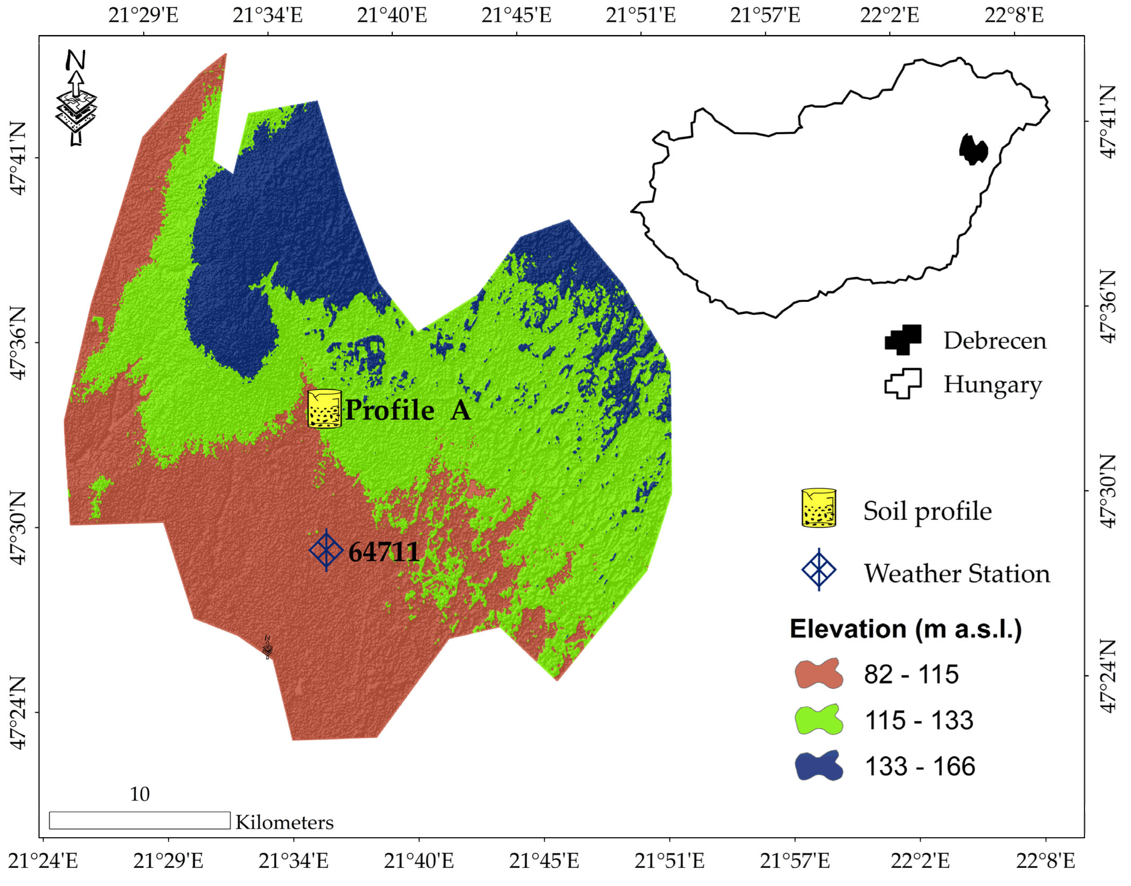
Figure 1. Location and topographic elevation of the study area in Debrecen, Hungary, showing the reference soil profile (Profile A) and the meteorological monitoring station (HMS ID: 64711) overlaid on the local digital elevation model (DEM) across the study area. The inset map indicates the location of the Debrecen municipality within Hungary.
Water 18 02006 g001
Figure 2. Observed and HYDRUS-1D simulated daily volumetric water content ( cm 3 / cm 3 ) across four monitored soil profile depths: (a) 30   cm , (b) 60   cm , (c) 80   cm , and (d) 140   cm at Soil Profile A (University of Debrecen Campus). Light grey shaded area indicates the initial model spin-up period (1 May to 18 September 2023) before model calibration. Continuous line segments represent measured sensor readings after linear temporal interpolation across minor logging gaps.
Water 18 02006 g002
Figure 3. Effect of Infiltration Pond Size on Cumulative Bottom Flux Under a Pessimistic Climate Scenario (HadGEM2_CCLM_RCP8.5).
Water 18 02006 g003
Figure 4. Cumulative bottom flux under different climate change scenarios for S3 (500 m2).
Water 18 02006 g004
Table 1. Physical and chemical properties of Soil Profile A at the University of Debrecen Campus.
Soil HorizonDepth Range (cm)Sensor Depth (cm)Sand (%)Silt (%)Clay (%)Texture ClasspHHumus (%)EC (mS/cm)CaCO3 (%)
A10–353065.3921.1913.42Sandy loam7.531.2750.2290.9
A235–706065.0420.8214.14Sandy loam7.631.1830.221.07
B70–908052.9326.3920.68Sandy clay loam8.210.6210.20913.63
BC90–130 45.0831.9422.98Loam8.280.5310.2222.59
C130–15014031.9646.1721.87Loam8.390.2180.25723.41
Table 2. Simulated cumulative bottom flux, ET/PET ratio, and root zone saturation under historical and projected climate scenarios.
Source/Climate ModelScenarioCum. Bottom Flux (mm)Avg. ET/PET Ratio (-)Avg. Root Zone Saturation (%)
HMS (2017–2023)S0−0.490.5635
FORESEE (2017–2023)S0−0.650.5736
FORESEE (1991–2023)S0−18.060.5440
S1−692.560.6557
S2−1023.530.6660
S3−1730.980.6764
MPI_CCLM_RCP4.5S0−1.310.5335
S1−393.570.6855
S2−645.530.6858
S3−1194.100.6963
MPI_CCLM_RCP8.5S0−1.040.5133
S1−303.960.6953
S2−526.850.6957
S3−1027.60.7162
CNRM_CCLM_RCP4.5S0−1.050.5134
S1−355.050.6754
S2−596.090.6757
S3−1127.20.6861
CNRM_CCLM_RCP8.5S0−1.750.5636
S1−500.760.6957
S2−782.520.6960
S3−1388.20.764
HadGEM2_CCLM_RCP4.5S0−1.530.5135
S1−391.590.6454
S2−621.310.6557
S3−1127.70.6661
HadGEM2_CCLM_RCP8.5S0−1.170.4734
S1−311.20.6151
S2−516.140.6254
S3−973.290.6358
Disclaimer/Publisher’s Note: The statements, opinions and data contained in all publications are solely those of the individual author(s) and contributor(s) and not of MDPI and/or the editor(s). MDPI and/or the editor(s) disclaim responsibility for any injury to people or property resulting from any ideas, methods, instructions or products referred to in the content.