Article

Feasibility Screening of River Basin Management Plan Delivery Under War-Driven Uncertainty: The Ukrainian Tisza Sub-Basin (2025–2030)


1
Department of Civil Engineering and Geology (DECG), Faculty of Exact Sciences and Engineering (FCEE), University of Madeira (UMa), 9000-082 Funchal, Portugal
2
CITUR-Madeira-Research Centre for Tourism Development and Innovation, 9000-082 Funchal, Portugal
3
VALORIZA-Research Centre for Endogenous Resource Valorization, Polytechnic Institute of Portalegre (IPP), 7300-555 Portalegre, Portugal
4
Research Group on Environment and Spatial Planning (MAOT), University of Extremadura, 06071 Badajoz, Spain
5
RISCO—Civil Engineering Department, University of Aveiro, 3810-193 Aveiro, Portugal
6
OSEAN—Outermost Regions Sustainable Ecosystem for Entrepreneurship and Innovation, 9000-082 Funchal, Portugal
7
Institute of Mechanical Engineering, Ivano-Frankivsk National Technical University of Oil and Gas, 15, Karpatska St., 76019 Ivano-Frankivsk, Ukraine
8
Institute for Sustainable and Circular Construction, Faculty of Civil Engineering, The Technical University of Košice, 04200 Kosice, Slovakia
9
Centre for Interdisciplinary Research of Uzhhorod National University, Uzhhorod National University, 88000 Uzhhorod, Ukraine
*
Author to whom correspondence should be addressed.
Water 2026, 18(10), 1178; https://doi.org/10.3390/w18101178
Submission received: 3 March 2026 / Revised: 8 May 2026 / Accepted: 11 May 2026 / Published: 13 May 2026

Abstract

River Basin Management Plans (RBMPs) developed under the EU Water Framework Directive (WFD) assume stable monitoring, institutional continuity, and predictable implementation capacity—conditions that are undermined by war-driven uncertainty. This study assesses the feasibility of delivering the 2025–2030 RBMP in the Ukrainian Tisza sub-basin using a combined approach that integrates structured document analysis, a measure-level dataset derived from the Programme of Measures annexes, and a feasibility-screening framework linking expected environmental contribution, implementation dependency, and evidence readiness. The empirical basis covers 120 planned measures in a transboundary sub-basin with a large and heterogeneous surface-water portfolio. While surface-water monitoring remained operational in 2023, groundwater evidence was critically constrained because monitoring had been discontinued since 2018, and groundwater status and risk assessments had not been completed by the end of 2023. The analysis identifies a compliance-critical subset of high-contribution, high-dependency measures, particularly capital-intensive wastewater, monitoring, and groundwater-related interventions, whose implementation and verification are most vulnerable to wartime disruption. The study proposes an evidence-gap closure sequence and a verification-ready prioritisation logic for the 2025–2030 cycle, offering a transferable framework for stress-testing RBMP delivery in transboundary basins under high uncertainty.

1. Introduction

The EU Water Framework Directive (WFD) established an integrated, river-basin-based model of water governance in which River Basin Management Plans (RBMPs) and their Programmes of Measures (PoMs) serve as the principal instruments for preventing deterioration and achieving good ecological and chemical status of surface waters and groundwater [1]. In practice, however, the effectiveness of RBMPs depends not only on well-defined environmental objectives and pressure assessments, but also on the continuity of monitoring, the enforceability of permitting and compliance regimes, the availability of financing, and the institutional capacity to deliver measures over the full planning cycle [2]. Even under peacetime conditions, these implementation requirements are often weakened by fragmented data, delayed investments, and uneven administrative capacity.
Such constraints become especially consequential in transboundary basins, where upstream monitoring, planning, and implementation directly shape downstream environmental conditions and shared compliance trajectories. In these settings, the credibility of an RBMP depends not only on whether appropriate measures are selected, but also on whether they can be implemented, monitored, and verified in a sufficiently robust and timely manner. This makes transboundary river basins particularly sensitive to disruptions affecting institutional continuity, infrastructure delivery, and evidence generation [3].
Russia’s full-scale war against Ukraine has introduced a qualitatively different level of uncertainty into WFD-oriented water management. Wartime conditions can disrupt laboratory and monitoring operations, delay procurement and construction, constrain access to infrastructure, reduce enforcement capacity, and redirect institutional resources to urgent emergency needs. They may also alter pressure patterns indirectly through population displacement, relocation of economic activity, and changes in service demand and local resource use. Under such conditions, the standard planning logic of RBMPs—where measures are selected, financed, implemented, and then verified through stable monitoring systems—can no longer be assumed to operate without interruption. The resulting challenge is not whether environmental ambition should be lowered, but how RBMP delivery can be prioritised and assessed under conditions in which implementation and verification capacities are themselves unstable [4,5].
The Ukrainian Tisza sub-basin provides a particularly relevant case for examining this problem. As part of the Danube River Basin District, it is an explicitly transboundary system shared with Romania, Hungary, and Slovakia, and it occupies 12,765 km2 within Zakarpattia Oblast. The 2025–2030 planning cycle defines a complex management portfolio for this sub-basin, including 481 delineated surface-water units and a Programme of Measures comprising 120 planned interventions. At the same time, the planning documentation reveals a pronounced asymmetry in the evidential baseline: surface-water monitoring remained operational in 2023, whereas groundwater monitoring had not been conducted since 2018, and groundwater status and risk assessments had not been completed by the end of 2023. This combination of transboundary relevance, a large and diverse measure portfolio, and uneven verification capacity makes the Ukrainian Tisza sub-basin an analytically critical case for examining RBMP deliverability under war-driven uncertainty [6,7].
In addition to its planning relevance, this case is environmentally and socially consequential because wartime disruption affects not only formal implementation capacity, but also the resilience of sensitive headwater ecosystems and the reliability of water and sanitation services on which local communities depend. In such settings, failures of monitoring, delayed investments, or incomplete verification may carry both ecological and human-security implications, including for downstream transboundary users.
Despite the maturity of the WFD planning architecture, a practical methodological gap remains. RBMPs are rarely assessed through a framework that explicitly links three dimensions at the level of individual measures: first, the expected environmental contribution of a measure to pressure reduction and status improvement; second, the implementation dependencies required for its delivery, such as finance, procurement, coordination, permitting, and time horizon; and third, the readiness of the available evidence base to support prioritisation and verification-grade reporting. For conceptual clarity, three operational terms are used throughout this study. Evidence readiness is defined here as the degree to which available monitoring coverage, temporal continuity, laboratory capacity, and documentary traceability are sufficient to verify both implementation progress and environmentally meaningful change within the planning cycle. Verification-grade reporting refers to reporting supported by traceable monitoring or administrative evidence that allows implementation and outcomes to be independently checked rather than described only narratively. Compliance critical path denotes the subset of measures whose delay, under-delivery, or non-verifiability would most strongly compromise progress towards WFD-relevant objectives because they combine high expected environmental contribution with high implementation dependency. Without such an approach, technically justified measures may remain difficult to implement in practice, while other actions may be formally included in the plan but lack the monitoring basis required to demonstrate their effects within the planning cycle [8].
This study addresses that gap by developing a feasibility-screening approach for the 2025–2030 RBMP of the Ukrainian Tisza sub-basin. It combines structured analysis of the RBMP narrative and annexes with a measure-level assessment framework that links expected environmental contribution, implementation dependency, and evidence readiness [9,10]. The study is guided by three questions: (1) which planned measures are likely to make the greatest contribution to WFD-relevant outcomes while also facing the strongest delivery constraints; (2) where do current monitoring and data limitations create bottlenecks for credible verification; and (3) how should measures be sequenced so that the most consequential evidence gaps are addressed early in the planning cycle? These questions are especially important in war-affected basins, where implementation failure is rarely caused by a single factor. Instead, environmental relevance, delivery dependency, and evidential weakness often interact. A measure may be environmentally important yet difficult to implement under unstable financing or procurement conditions, while another may be implemented formally but remain weakly verifiable because the underlying monitoring chain is incomplete. This makes it necessary to distinguish not only what should be done in principle, but what can be delivered and credibly verified within the 2025–2030 cycle.
The contribution of the paper is twofold. First, it provides a basin-specific, verification-oriented prioritisation of the Tisza Programme of Measures under war-driven uncertainty. Second, it proposes a transferable methodological framework for stress-testing RBMP delivery in transboundary basins where institutional continuity, monitoring stability, and implementation capacity cannot be taken for granted. In this way, the study moves beyond a descriptive reading of the plan and offers an applied approach for distinguishing between nominal ambition and operational feasibility in high-uncertainty water-governance settings [11].

2. Study Area and Planning Context

2.1. Location and Transboundary Setting

The study focuses on the Ukrainian part of the Tisza sub-basin within the Danube River Basin District. This sub-basin forms part of a transboundary river system shared by Ukraine, Romania, Hungary, and Slovakia. Within Ukraine, the Tisza sub-basin covers 12,765 km2, which corresponds to approximately 2.1% of the national territory, and is located entirely within Zakarpattia Oblast. The hydrographic network comprises 165 rivers with catchment areas exceeding 10 km2 and 8 reservoirs, reflecting a dense and hydrologically interconnected headwater system with clear upstream–downstream linkages [12,13].

2.2. Hydrological and Management Characteristics

According to the river basin management plan, the Ukrainian part of the Tisza sub-basin occupies the upper reaches of the basin, where an important share of runoff is generated, and key features of water chemistry are formed. This upstream position increases the significance of local pressures and management responses for downstream sections of the basin. The sub-basin is also characterised by a flood-prone runoff regime, with recurrent floods of different magnitudes affecting settlements, infrastructure, and economic activity. In management terms, the basin is not only hydrologically sensitive but also spatially complex, as it combines mountainous and lowland environments and includes water bodies subject to multiple types of anthropogenic modification [14,15].

2.3. Surface-Water Delineation and Monitoring Baseline

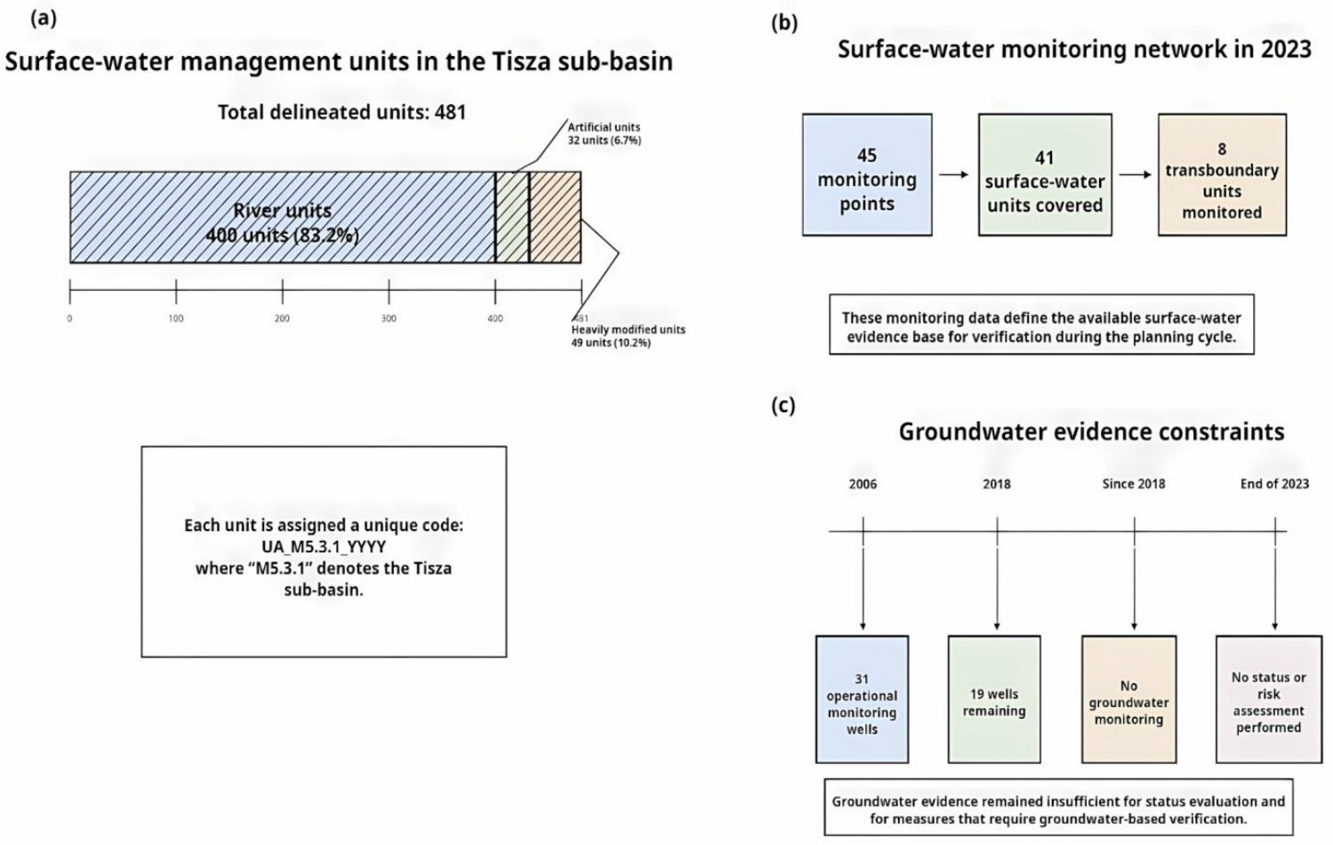
For planning and reporting purposes, the 2025–2030 river basin management plan delineates 481 surface-water units in the Ukrainian part of the Tisza sub-basin. These include 400 river units, 32 artificial units, and 49 heavily modified units. Each unit is assigned a unique code in the format UA_M5.3.1_YYYY, where the identifier “M5.3.1” denotes the Tisza sub-basin. This delineation constitutes the territorial framework used to connect environmental pressures, monitoring information, and planned interventions.
The available monitoring evidence is markedly uneven between surface waters and groundwater. For the purposes of this study, the evidential base relevant to verification should be understood as including both parameter scope and monitoring continuity. For surface waters, this encompasses biological quality elements, supporting physico-chemical parameters, hydromorphological characteristics, and chemical-status-related indicators used to assess ecological and chemical conditions. For groundwater, the relevant evidence base includes both quantity-related and quality-related parameters, including groundwater-level behaviour, abstraction-related pressures, and pollutant-relevant hydrochemical indicators. This distinction is important because the strength of verification depends not only on the presence of monitoring sites, but also on whether the monitored variables are sufficient to support status-relevant interpretation. In 2023, surface-water monitoring was conducted at 45 monitoring points covering 41 surface-water units, including 8 transboundary units monitored through interstate cooperation arrangements. This provides an operational, although limited, basis for status assessment and for the future verification of selected measures during the planning cycle.
The temporal resolution of monitoring is also critical for interpreting evidence readiness. In practice, the value of a monitoring network depends not only on spatial coverage, but also on whether repeated observations are available at a frequency sufficient to detect change within the planning cycle. In the present context, this means that verification capacity must be understood in temporal as well as spatial terms: measures can be formally implemented, yet still remain weakly verifiable if repeated observations are too sparse, interrupted, or inconsistent to support trend detection.
Groundwater evidence is substantially weaker. An inventory carried out in 2006 identified 31 operational monitoring wells, whereas only 19 remained in operation in 2018. Since 2018, groundwater monitoring has not been conducted, and by the end of 2023, neither groundwater status assessment nor groundwater risk assessment had been completed. For the present study, this asymmetry is not a secondary background feature; it is a central characteristic of the planning environment because it directly affects the credibility of measure verification, especially where groundwater conditions or groundwater–surface water interactions are involved (Figure 1) [16].
More specifically, the groundwater monitoring gap weakens verification in three ways. First, it limits the establishment of a reliable baseline against which post-implementation change can be assessed. Second, it constrains the detection of temporal trends in groundwater quantity and quality during the 2025–2030 planning cycle. Third, it reduces confidence in the verification of measures whose effects depend on groundwater–surface water interactions or on diffuse pathways of pollution infiltration. For data-poor areas, interim verification may therefore require the use of proxy evidence, such as groundwater abstraction records, water-level observations from still-accessible wells, spring discharge behaviour, dry-season baseflow patterns, nitrate- and ammonium-related indicators, electrical conductivity, chloride and sulphate concentrations, sanitation coverage, and the prevalence of septic-system reliance in unserved settlements.

2.4. Dominant Pressures and Planning Relevance Under War-Driven Uncertainty

The planning context of the Tisza sub-basin is strongly influenced by municipal wastewater pressures and incomplete sanitation coverage. Average coverage by centralised wastewater collection is reported at approximately 60.5%, while wastewater from unserved areas is discharged either directly into surface waters or into septic systems with possible infiltration into deeper horizons. For 2020, the plan identifies the housing-and-utilities sector as the dominant contributor to returned wastewater discharges in the sub-basin, accounting for 78.8% of the total, or about 30.074 million m3. Uzhhorod and Mukachevo are reported as the principal municipal discharge centres, representing 71% and 18% of total municipal discharge volumes, respectively. The plan also notes that routine discharge control mainly targets parameters included in permitted effluent limits, whereas the presence and magnitude of hazardous substances require additional confirmation through research monitoring and targeted screening of wastewater samples [17].
This is methodologically important for the present study because it shows that documentary pressure identification and verification-grade evidence are not always equivalent. In other words, a pressure may be clearly recognised in the planning documents, yet the available monitoring basis may still be insufficient to confirm its magnitude, temporal variability, or response to intervention within a single planning cycle. This problem is especially relevant under war-driven uncertainty, where routine monitoring continuity, laboratory access, and targeted analytical capacity may all be affected indirectly.
The Programme of Measures for the Tisza sub-basin includes 120 measures, of which 101 are core measures, and 19 are additional measures. At this stage, these figures indicate the scale of the management portfolio rather than its operational feasibility. The question of how these measures are distributed across contribution, dependency, and evidence-readiness categories is examined in later sections through the feasibility-screening framework. The plan specifies that implementation should begin no later than the third year of the planning cycle, that is, by 1 January 2028. At the same time, the sub-basin must be interpreted in the context of war-driven uncertainty. The planning documentation does not report documented direct war-related impacts on surface-water or groundwater units within the Tisza sub-basin, yet this does not eliminate wartime implementation risks. Rather, it indicates that feasibility challenges are more likely to arise through indirect pathways, including reduced monitoring continuity, procurement delays, constrained delivery capacity, and pressure shifts associated with broader wartime disruptions [18]. In addition, the basin-wide planning framework explicitly recognises the impact of hostilities as a pressure category, while the annexed measure template includes a dedicated field for the restoration of war damage. Taken together, these features make the Ukrainian part of the Tisza sub-basin an appropriate case for examining whether a formally adopted Programme of Measures remains operationally feasible and verification-ready under high uncertainty [19,20].

3. Materials and Methods

3.1. Research Design and Documentary Corpus

This study employed a mixed documentary design to assess the feasibility of delivering River Basin Management Plan measures under war-driven uncertainty in a transboundary headwater basin. The analytical strategy combined two complementary evidence streams [21,22,23,24,25,26,27,28]. The first consisted of a structured synthesis of peer-reviewed literature used to identify how previous research has addressed implementation performance in river basin planning, monitoring adequacy, transboundary interdependence, and governance under high uncertainty. The second consisted of a document-based empirical assessment using the Danube River Basin Management Plan for the 2025–2030 cycle and its annexed tables of planned measures for the Ukrainian part of the Tisza sub-basin [29,30,31,32]. The design was therefore explicitly ex ante and rule-based: it was intended to identify likely delivery and verification bottlenecks within the planning cycle on the basis of documented plan content, rather than to evaluate realised ecological outcomes or completed implementation performance.
To situate the Tisza case within a common planning architecture, the same annex-table format was also examined for two additional sub-basins within the Danube River Basin District, namely the Prut and Siret sub-basin and the Lower Danube sub-basin. This within-plan comparison was used as an internal benchmark rather than as a separate comparative case-study design, because all three sub-basin portfolios were reported through the same documentary template and under the same planning cycle [33,34]. The benchmark comparison focused on documentary comparability rather than contextual equivalence. Specifically, the three sub-basin portfolios were compared in terms of measure counts, thematic composition, delivery horizon, reported cost structure, and the prevalence of measures later classified as dependency-heavy or evidence-constrained under the feasibility-screening framework.
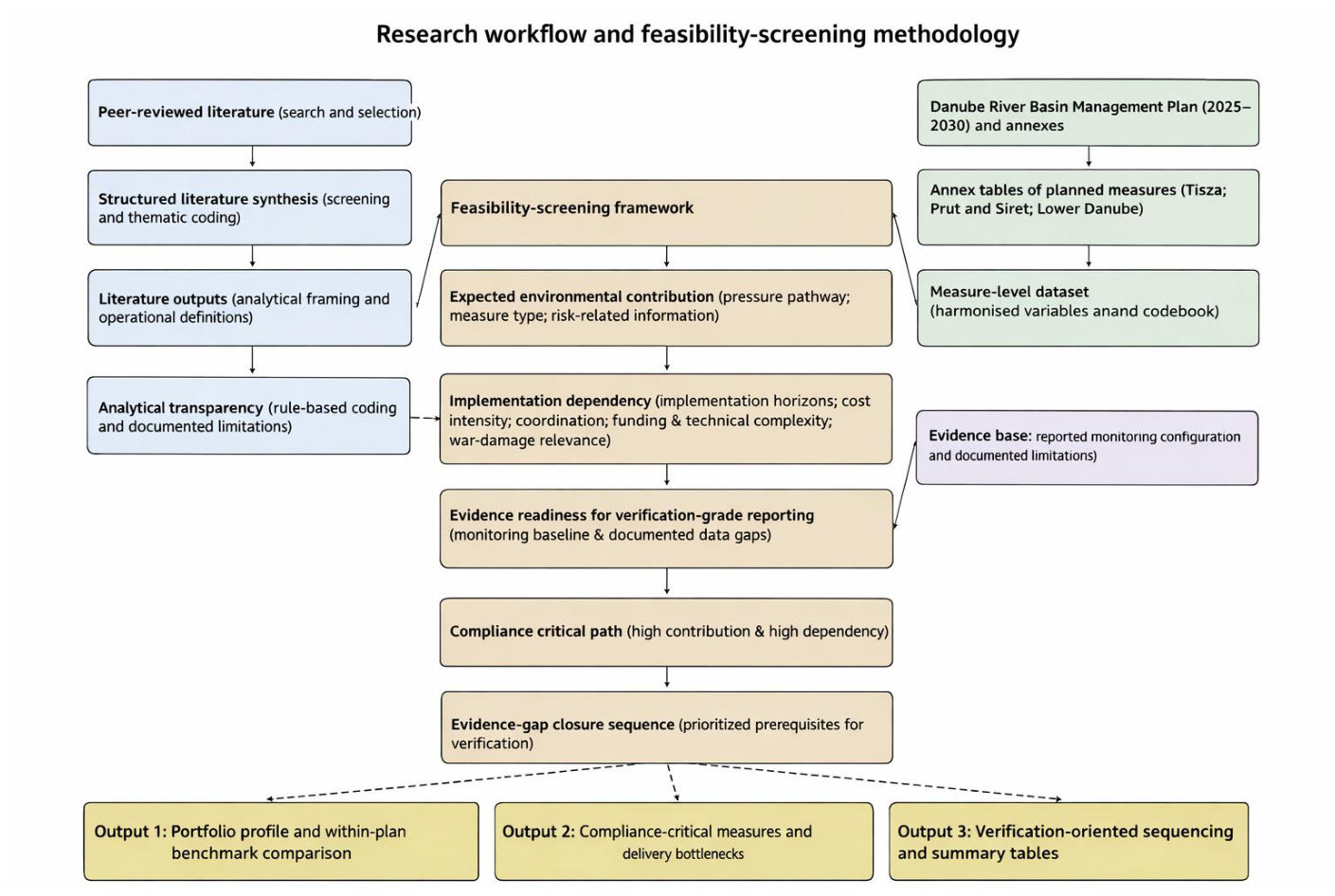
The empirical corpus, therefore, included: (i) the narrative sections of the Danube River Basin Management Plan relevant to the Tisza sub-basin; (ii) the complete annex tables listing measures for the Tisza sub-basin; and (iii) the corresponding annex tables for the Prut and Siret and Lower Danube sub-basins [35,36]. The unit of analysis was one planned measure, with each measure treated as one record in the empirical dataset. Each record was coded through explicit rule-based interpretation of the annex fields so that the transition from documentary description to analytical classification remained transparent and reproducible. Where annex wording was descriptive rather than standardised, harmonisation was applied conservatively in order to preserve comparability across measures and sub-basins. The overall analytical workflow, including the integration of literature synthesis, measure-level dataset construction, feasibility screening dimensions, and output structure, is summarised in Figure 2.

3.2. Literature Search and Structured Synthesis

The literature component was designed as a structured methodological synthesis rather than a formal systematic review. Searches were conducted in Web of Science and Scopus and were complemented by targeted searches in publisher platforms relevant to hydrology, water governance, environmental policy, and infrastructure management. The search covered peer-reviewed journal articles and review papers available up to 2026 and included publications in both English and Ukrainian in order to capture the international and regional dimensions of river basin planning [37]. Publications were included if they addressed at least one of the following analytical needs: implementation barriers in river basin planning, monitoring adequacy for status assessment or verification, transboundary implementation interdependence, or governance responses under conflict, institutional instability, or other high-uncertainty conditions. Sources were excluded when they addressed water management only in very general terms without offering transferable conceptual, empirical, or methodological relevance to the present framework.
Search strings were organised into four thematic clusters: (i) implementation performance and delivery barriers in river basin management planning; (ii) monitoring design, uncertainty, and evidence requirements for verification-oriented assessment; (iii) transboundary governance and upstream–downstream interdependencies; and (iv) water governance and water infrastructure management under armed conflict and other high-uncertainty conditions. Representative combinations of search terms included “river basin management plan”, “programme of measures”, “implementation barriers”, “monitoring adequacy”, “verification”, “groundwater monitoring”, “transboundary basin”, “water governance under conflict”, and related variants. These combinations were adjusted iteratively across databases in order to capture both WFD-specific literature and broader studies on environmental governance under disrupted implementation conditions. Publications were retained if they provided empirical findings, comparative evidence, or transferable analytical approaches relevant to at least one of these thematic clusters [38].
For each included source, the following information was extracted: governance context, planning instrument, monitoring approach, assumptions about evidence adequacy, reported implementation barriers, and any operational evaluation logic suitable for adaptation to feasibility screening and prioritisation. In addition, each source was examined for whether it reported convergent or divergent findings regarding the relationship between monitoring continuity, implementation capacity, and the credibility of environmental reporting. This made it possible to use the literature not only for contextual grounding, but also as a structured comparison base for interpreting how the Tisza findings align with, extend, or differ from earlier studies. The purpose of this synthesis was not to compile a bibliometric inventory, but to establish the conceptual basis of the study and to inform the operational definition of the empirical screening dimensions [39,40]. Accordingly, the literature synthesis served two functions: first, to support the operationalisation of contribution, dependency, and evidence-readiness dimensions; and second, to provide an explicit interpretive basis for the later comparison of the study’s findings with existing RBMP, monitoring, and high-uncertainty governance research.

3.3. Measure-Level Dataset Construction and Variable Harmonisation

The empirical dataset was compiled from the annex tables of the Danube River Basin Management Plan for 2025–2030. For the Tisza sub-basin, the annex tables list 120 planned measures, while the same table structure is also used for the Prut and Siret and Lower Danube sub-basins. Each measure was transcribed into a structured dataset with one row per measure and one set of harmonised variables per record [41].
The annex tables provide standardised descriptors that support measure-level analysis. These include the main water-environmental problem addressed, measure type, textual description and technical specification, responsible institutions, implementation period, linkage to surface-water and groundwater management units, reported risk labels, affected population, references to protected areas, physical implementation units, investment costs, operation and maintenance costs, total costs, funding sources, and a dedicated field indicating whether a measure concerns restoration of war damage. These fields were retained because they capture both the intended environmental role of a measure and the conditions affecting its practical delivery [42].
For clarity and reproducibility, the variable structure used for dataset construction is summarised in Table 1. The detailed coding logic applied to harmonise documentary fields and derive the analytical screening variables is provided in Supplementary Table S1, while the structure of the resulting measure-level analytical dataset and its screening outputs is shown in Supplementary Figure S1.
For analytical consistency, the extracted variables were organised into four groups: (1) pressure and objective linkage, including the environmental problem addressed and the measure category; (2) spatial linkage, including administrative location and associated management-unit codes; (3) implementation attributes, including responsible organisations, implementation period, funding sources, and the war-damage restoration field; and (4) cost and scale proxies, including investment costs, operation and maintenance costs, total costs, affected population, and physical implementation units [43,44,45,46].
A codebook was developed to map each derived variable to the corresponding annex-table field and to document all standardisation steps. For the three core screening dimensions, the codebook also specified ordinal classification rules so that each measure could be assigned consistently to high, medium, or low analytical categories on the basis of documented attributes rather than interpretive judgement alone. These included harmonisation of cost variables, alignment of institution names, identification of multi-year capital works from the implementation period and technical specification, and binary flagging of variables used in the screening framework [47].

3.4. Feasibility-Screening Framework

A feasibility-screening framework was developed to assess each planned measure across three analytical dimensions: expected environmental contribution, implementation dependency, and evidence readiness. The purpose of the framework was not to predict implementation outcomes, but to identify where formally adopted measures are most likely to face delivery and verification constraints during the 2025–2030 planning cycle. This approach responds to the methodological problem identified in the study, namely that Programme of Measures delivery in wartime settings cannot be evaluated solely in terms of formal policy ambition, but must also be examined in relation to implementation conditions and the strength of the available evidence base [48]. All coding thresholds and decision rules are reported in Supplementary Table S1. These thresholds are rule-based rather than statistically derived: cost was coded using reported cost classes, implementation horizon was coded as single-date or multi-year from the annex implementation period, and the three screening dimensions were assigned ordinally according to documented co-occurrence of pressure relevance, delivery constraints, and evidence limitations.

3.4.1. Expected Environmental Contribution

Expected environmental contribution was assessed using documentary proxies reported in the annex tables and in the river basin management plan narrative. The primary proxies included the main water-environmental problem addressed, the type of measure proposed, and the risk-related information associated with the targeted management units [49]. Measures were classified as having high expected contribution when they addressed major documented pressure pathways and/or management units reported at risk; medium expected contribution when their anticipated effect was relevant but more localised, indirect, or supportive; and low expected contribution when their role was primarily preparatory, administrative, or only weakly linked to identified risk conditions. This dimension was therefore used to approximate the likely significance of each measure for pressure reduction and for progress toward plan-relevant environmental objectives [50]. In practical terms, large wastewater treatment and sewerage measures targeting major documented pollution pathways were typically treated as high-contribution measures, whereas preparatory, educational, or purely administrative actions were more likely to fall into the medium- or low-contribution categories unless they directly enabled status-relevant intervention in high-risk units.

3.4.2. Implementation Dependency

Implementation dependency was used to assess the extent to which delivery relied on conditions that are particularly vulnerable under war-driven uncertainty. This dimension was derived from documentary characteristics reported in the annex tables, including implementation period, cost structure, responsible organisations, funding sources, technical specification, and the field indicating whether a measure was linked to restoration of war damage [51]. Implementation dependency was therefore interpreted cumulatively rather than through any single attribute in isolation. For example, a measure was more likely to be classified as highly dependent when high cost intensity, a multi-year horizon, infrastructure-heavy works, and coordination across several responsible actors appeared together in the documentary record. Measures were classified as having high implementation dependency when several delivery constraints co-occurred, such as a multi-year implementation horizon, high cost intensity, multi-actor coordination, infrastructure-heavy technical specification, mixed funding requirements, or explicit war-damage relevance. Measures were classified as medium dependency when only some of these constraints were present, and as low dependency when implementation appeared comparatively straightforward and administratively contained. This dimension was intended to distinguish enabling or relatively simple measures from those whose delivery depends on sustained financing, coordination, physical works, and stable institutional capacity [52].

3.4.3. Evidence Readiness

Evidence readiness was used to assess whether implementation progress and outcomes could be credibly verified within the current planning cycle. This dimension relied on the monitoring configuration and evidence limitations documented in the river basin management plan. Measures linked primarily to monitored surface-water units were treated as having higher evidence readiness, whereas measures whose effects depended on groundwater conditions or groundwater–surface water interactions were treated as constrained where the documentary evidence base was discontinuous or incomplete [53]. This distinction was operationalised using the baseline monitoring conditions described in Section 2.3. In the Tisza sub-basin, surface-water monitoring provided a limited but functioning basis for verification, whereas groundwater-related measures were treated as evidence-constrained because the documented groundwater evidence chain was discontinuous and incomplete [54,55]. Where direct verification through a continuous groundwater monitoring chain was not possible, evidence readiness was interpreted conservatively. In such cases, measures were not treated as unverifiable in absolute terms, but as constrained in relation to verification-grade reporting, meaning that interim assessment would need to rely on proxy indicators, administrative records, or indirect hydrological signals rather than on a complete baseline-to-outcome monitoring sequence.

3.4.4. Compliance Critical Path and Evidence-Gap Closure Logic

Measures that combined high expected environmental contribution with high implementation dependency were classified as belonging to the likely compliance critical path. These measures were interpreted as the subset most likely to influence whether the Programme of Measures can generate substantial progress during the 2025–2030 cycle. For this subset, an additional analytical step was applied to identify the minimum monitoring, documentation, and enabling conditions required for credible verification [56]. This produced an evidence-gap closure sequence, through which monitoring-restoration steps, enabling actions, and verification prerequisites could be distinguished from measures that remain difficult to verify until those conditions are in place. In this way, the framework supports not only prioritisation of measures, but also sequencing of implementation in a form that is more consistent with the actual evidence constraints documented for the Tisza sub-basin [57]. This logic is especially relevant for practitioners and decision-makers operating under high uncertainty, because it helps distinguish between measures that are environmentally important in principle and those that are both urgent and realistically capable of generating credible, reportable progress within the current planning cycle.

3.5. Comparative Benchmark Across Sub-Basins

To avoid interpreting the Tisza measure portfolio in isolation, the study incorporated a within-plan comparative benchmark using the same annex-table format for the Prut and Siret and Lower Danube sub-basins. The purpose of this comparison was not to establish causal differences between sub-basins, but to situate the Tisza portfolio within a shared planning architecture and to determine whether its mix of delivery horizons, cost intensity, and high-dependency measures appeared distinctive under a harmonised reporting template [58]. Both absolute counts and relative shares were considered in order to distinguish between differences arising from portfolio size alone and differences in the internal structure of the three sub-basin measure sets.
The comparison focused on four aspects: the distribution of measures across problem categories, the balance between shorter- and longer-horizon interventions, the structure of reported costs, and the prevalence of measures characterised by high implementation dependency. Because all three sub-basin datasets were derived from the same annex format, this benchmark served as a robustness layer within the same planning system rather than as an external validation exercise [59,60]. At the same time, the benchmark was interpreted cautiously: it was intended to compare documentary portfolio structure and feasibility-relevant patterns rather than to rank the sub-basins normatively or to infer performance differences independently of their distinct hydrological, spatial, or institutional contexts.

3.6. Analytical Transparency and Limitations

To improve analytical transparency, all core variables used in the screening framework were derived through explicit rule-based interpretation of the annex-table fields, as summarised in Table 1 and Table S1. The study should be understood as an ex ante feasibility assessment based on officially reported planning documents rather than as an evaluation of implementation outcomes [61]. The analytical classifications, therefore, depend on documentary evidence available for the 2025–2030 planning cycle and do not substitute for future field-based verification. This limitation is particularly important in wartime or otherwise unstable settings, where official planning records may lag behind rapidly changing operational realities, including temporary service disruption, restricted site access, contractor withdrawal, laboratory interruptions, emergency discharge events, or short-term shifts in local population pressure. In addition, the literature component was designed as a structured methodological synthesis rather than a formal systematic review, and the screening framework relies on qualitative thresholds rather than statistical weighting procedures [62,63]. The study also does not incorporate stakeholder interviews, field auditing, or direct post-implementation measurement, and therefore cannot establish causal relationships between planned measures and realised environmental outcomes. Instead, it provides a structured assessment of where delivery and verification are most likely to become constrained within the documented planning architecture. These choices are consistent with the objective of the study, which is to assess whether the Programme of Measures is operationally deliverable and verification-ready under documented wartime uncertainty. For that reason, all classifications in this study should be interpreted as conservative analytical judgements designed to support prioritisation, comparison, and early identification of implementation risk, rather than as substitutes for future monitoring-based validation.

4. Results

4.1. Baseline Risk Profile and Verification Constraints in the Ukrainian Tisza Sub-Basin

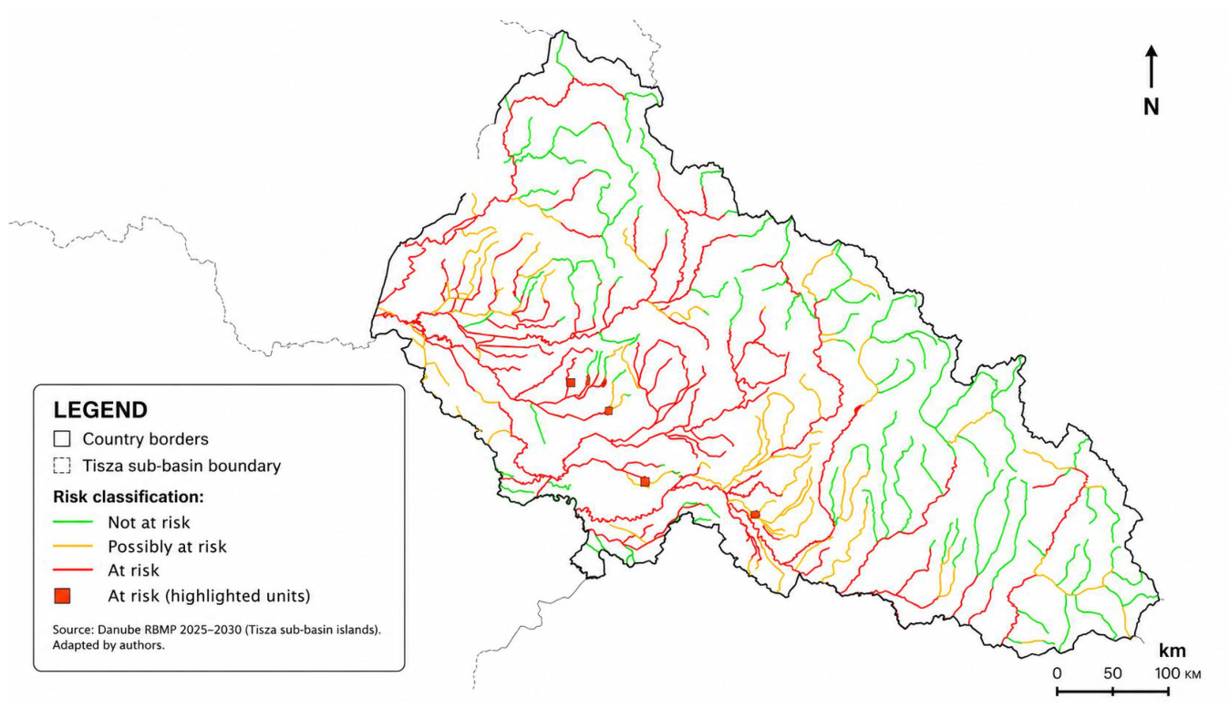
The 2025–2030 river basin management plan defines a heterogeneous baseline in which a substantial share of surface-water bodies are classified as being at risk of failing ecological objectives, while chemical-status risk appears more limited. Based on the anthropogenic pressure screening reported for the Tisza sub-basin, 214 surface-water bodies are classified as “not at risk”, 111 as “possibly at risk”, and 156 as “at risk” with respect to achieving good ecological status/potential. For chemical status, 445 surface-water bodies are classified as “not at risk”, whereas 36 are “at risk.” These baseline counts are analytically important because they define the environmental starting position against which the feasibility of the Programme of Measures must later be interpreted. However, they do not in themselves indicate whether the required measures are equally deliverable or equally verifiable within a single planning cycle. The spatial distribution of the reported risk classes across the Ukrainian Tisza sub-basin is shown in Figure 3 (adapted from the RBMP map materials) [64]. This distinction is particularly relevant for the present study because risk distribution and verification capacity are not identical: a basin may contain a substantial at-risk portfolio, yet still face unequal evidential conditions for confirming whether implemented measures actually generate status-relevant change.
The planning time horizon indicates that 2030 delivery is expected to be partial for the at-risk portfolio. The plan reports that 233 surface-water bodies are expected to achieve good ecological status/potential by the end of 2030, including maintenance of the 214 “not at risk” bodies and improvement of 19 bodies through implementation of the Programme of Measures. The remaining 248 “at risk/possibly at risk” surface-water bodies are reported as likely to require two to three planning cycles to reach the objective, conditional on sustained implementation [65].
Status assessment information suggests that the most problematic ecological conditions are concentrated in specific river units. Within the Danube district assessment for the Tisza sub-basin, six river water bodies are explicitly reported as being in “poor” ecological status (Martosh, Khustets, Repinka, Borzhava, Verke, and Tova), reflecting biological quality element non-compliance [66].
A critical constraint for feasibility and verification-grade reporting is the asymmetry between surface-water and groundwater evidence. Surface-water monitoring in 2023 was conducted at 45 monitoring points, covering 41 surface-water bodies, including 8 transboundary units monitored under interstate arrangements. In contrast, groundwater monitoring capacity has degraded substantially: an inventory recorded 31 operational wells in 2006, with 19 remaining in 2018, and no groundwater monitoring conducted since 2018; by the end of 2023, groundwater status and risk assessments were not completed [67].

4.2. Programme of Measures Portfolio: Scale, Timing, and Thematic Orientation

Against this baseline, the structural characteristics of the Programme of Measures can be examined in terms of thematic composition, cost profile, and delivery horizon. The Programme of Measures (PoM) for the Ukrainian Tisza sub-basin comprises 120 measures, including 101 core and 19 additional measures. The plan specifies that implementation should start no later than the third year of the 2025–2030 cycle (by 1 January 2028).
At thematic level, the PoM targets the dominant WFD-relevant pressure pathways identified in the plan narrative: reducing pollution by organic substances, nutrients, and hazardous substances (from point and diffuse sources); improving hydromorphological conditions (including river continuity and floodplain-related interactions); and mitigating impacts associated with planned infrastructure projects [68]. The RBMP also notes the transboundary context by accounting for planned measures in neighbouring countries and by referencing chemical-status information for transboundary surface-water bodies based on recent monitoring.
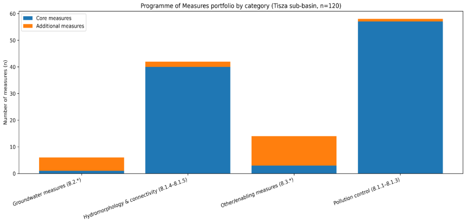
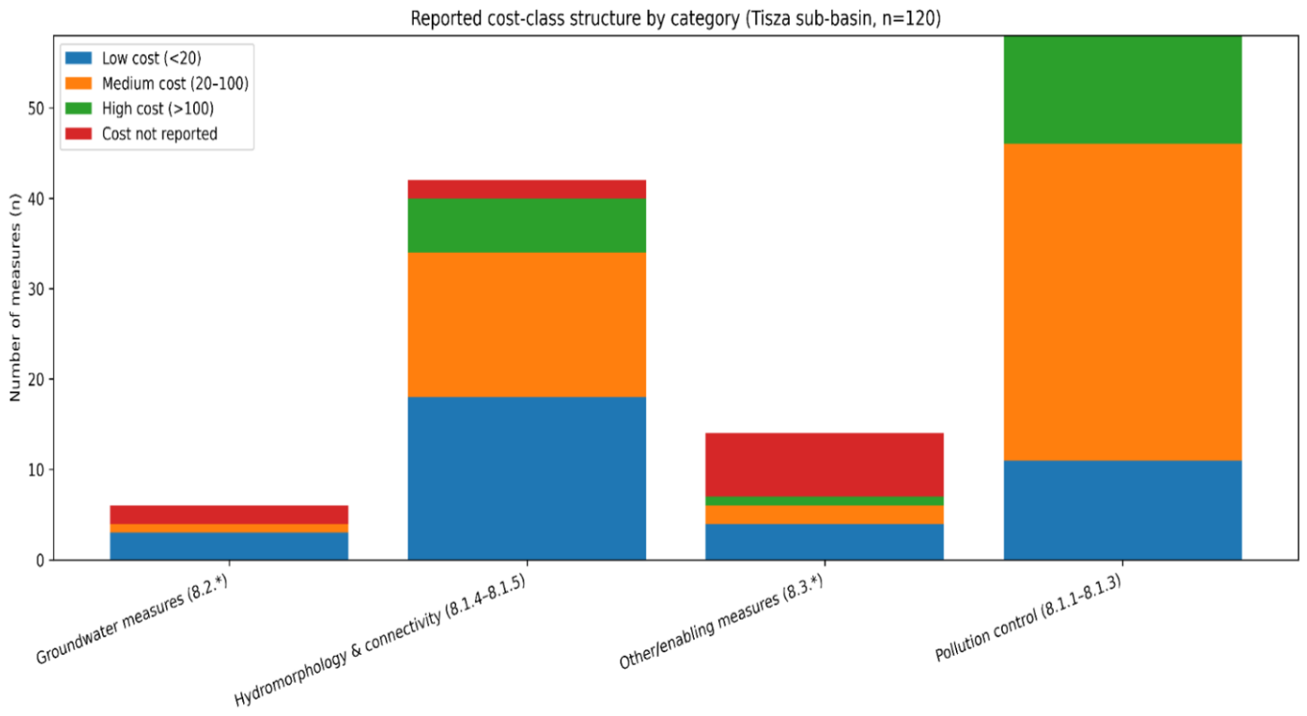
For analytical consistency with the annex reporting template, measures were grouped by Annex 11 section codes: 8.1.1–8.1.3 (surface waters—pollution control measures for organic substances, nutrients, and hazardous substances), 8.1.4–8.1.5 (surface waters—hydromorphology and connectivity measures, including continuity/floodplain-related actions), 8.2 (groundwater measures), and 8.3 (other/enabling measures, including planning-, monitoring-related, or administrative actions). As shown in Figure 4, the portfolio is dominated by measures falling under pollution control (8.1.1–8.1.3) and hydromorphology/connectivity (8.1.4–8.1.5), while groundwater measures (8.2) represent a small subset and are concentrated mainly in the additional programme. In quantitative terms, the PoM comprises 58 pollution-control measures (48.3%), 42 hydromorphology/connectivity measures (35.0%), 14 other/enabling measures (11.7%), and 6 groundwater measures (5.0%). The category structure is also uneven between core and additional actions: pollution control accounts for 57 core and 1 additional measure, hydromorphology/connectivity for 40 core and 2 additional measures, other/enabling actions for 3 core and 11 additional measures, and groundwater for 1 core and 5 additional measures.
The reported cost structure by category group is summarised in Figure 5, distinguishing low/medium/high cost classes and measures for which costs are not reported in the annex fields. Cost classes follow the Annex 11 cost reporting fields and were grouped as low (<20), medium (20–100), and high (>100) in reported total costs, with a separate class for measures where costs were not reported.
Across the full portfolio, 28 measures (23.3%) fall into the low-cost class, 61 (50.8%) into the medium-cost class, and 19 (15.8%) into the high-cost class, while 12 measures (10.0%) have no reported total cost in the annex fields. This means that 80 measures (66.7%) either require at least medium investment or lack complete cost specification, reinforcing the need for cautious feasibility assessment under wartime uncertainty.
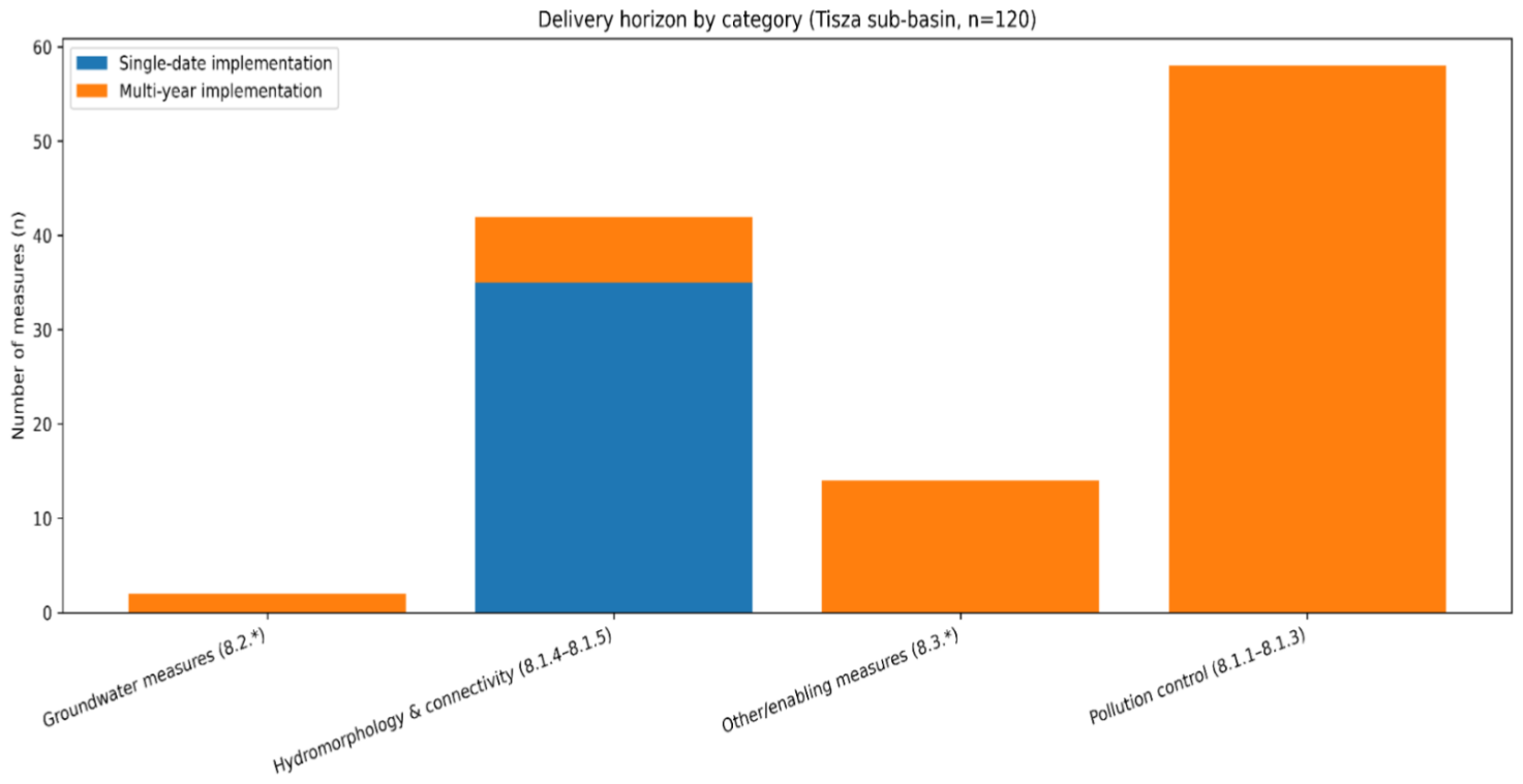
Delivery horizon patterns are shown in Figure 6. Delivery horizon was coded as multi-year when the annex implementation period specified a start and end year (or multi-year interval), and as single-date when only one implementation year/date was provided. The resulting distribution indicates that a substantial part of the portfolio is formulated as multi-year interventions, consistent with the prevalence of infrastructure-type and coordination-intensive measures [69]. Among the measures with a codable implementation horizon, 81 were classified as multi-year (69.8%) and 35 as single-date (30.2%). Four measures did not contain a sufficiently specific implementation-period entry in the annex fields to be classified and were therefore excluded from the delivery-horizon comparison.

4.3. Feasibility Screening Outputs: Contribution–Dependency Patterns and the Verification Bottleneck

Applying the feasibility-screening framework to the measure-level dataset yields a structured classification of measures by expected environmental contribution, implementation dependency, and evidence readiness. The portfolio-level evidence for dependency is consistent with the predominance of multi-year interventions reported across the thematic blocks (see Figure 6) and with the distribution of reported cost classes (see Figure 5), which together indicate that a substantial share of measures is formulated as infrastructure-type or coordination-intensive actions rather than single-date administrative steps [70,71]. The compliance-critical shortlist identified in Table 2 comprises 10 measures (8.3% of the full PoM), nine of which belong to the pollution-control block and one to hydromorphology/connectivity. Their cumulative reported total cost is 4343.1 mln UAH, confirming that a relatively small fraction of the portfolio concentrates a disproportionate share of delivery risk and strategic importance.
The shortlist of compliance-critical path candidates (Table 2) is dominated by measures from the pollution-control block (8.1.1–8.1.3) and includes a smaller contribution from hydromorphology/connectivity (8.1.4–8.1.5). These measures are consistently reported as multi-year and associated with high total-cost classes in Annex 11, implying elevated procurement and coordination sensitivity over the 2025–2030 cycle. In contrast, groundwater-linked measures (8.2.*) form a smaller subset of the overall portfolio, but their evidence readiness is constrained: the groundwater monitoring discontinuity reported for the baseline period limits verification-grade reporting for measures requiring groundwater confirmation [72]. The groundwater-linked evidence-constrained subset is summarised in Table 3 and should be interpreted in conjunction with the surface-water monitoring baseline documented for 2023 (Section 4.1). The evidence-constrained groundwater-linked subset comprises 6 measures (5.0% of the full portfolio). Four of these measures have reported costs totalling 43.981 mln UAH, while two measures do not report total costs, underscoring that verification difficulty is not confined to capital-intensive actions alone.
Table 2. Compliance-critical path candidates in the Ukrainian Tisza Programme of Measures (Annex 11, Danube RBMP 2025–2030). The table lists a shortlist of measures characterised by high implementation dependency (multi-year implementation and high reported total-cost class) and high expected contribution (dominant pressure-control and hydromorphology/connectivity blocks). Evidence readiness is reported as surface-water baseline available for verification [73].
Measure IDAnnex 11 BlockReported Cost ClassTotal Cost (mln UAH)Evidence ReadinessMeasure Title (English; Literal)
C-0938.1.1–8.1.3High (>100)1453.2Surface-water baselineReconstruction of wastewater treatment facilities and networks, city of Uzhhorod
C-0398.1.1–8.1.3High (>100)540.0Surface-water baselineReconstruction of wastewater treatment facilities, city of Khust
C-0598.1.1–8.1.3High (>100)503.0Surface-water baselineReconstruction of wastewater treatment facilities and sewer network, city of Berehove
C-0148.1.1–8.1.3High (>100)450.0Surface-water baselineReconstruction of wastewater treatment facilities, city of Vynohradiv
C-0638.1.1–8.1.3High (>100)369.0Surface-water baselineReconstruction of wastewater treatment facilities and sewer network, city of Svaliava
C-0998.1.4–8.1.5High (>100)320.0Surface-water baselineEstablishment of water protection zones and riparian buffer strips for water bodies
C-0028.1.1–8.1.3High (>100)273.6Surface-water baselineReconstruction of wastewater treatment facilities, city of Rakhiv
C-0088.1.1–8.1.3High (>100)180.0Surface-water baselineReconstruction of wastewater treatment facilities, city of Tiachiv
C-0168.1.1–8.1.3High (>100)129.1Surface-water baselineReconstruction of wastewater treatment facilities and sewer network, city of Chop
C-0108.1.1–8.1.3High (>100)125.2Surface-water baselineConstruction of wastewater treatment facilities and sewer network, Bushtyno
Table 3. Evidence-constrained groundwater-linked measures in the Ukrainian Tisza Programme of Measures (Annex 11, Danube RBMP 2025–2030). The table lists measures assigned to groundwater thematic blocks (8.2.*) or explicitly requiring groundwater confirmation. These measures are flagged as evidence-constrained due to the documented groundwater monitoring gap in the planning baseline [74].
Measure IDAnnex 11 BlockReported Cost ClassTotal Cost (mln UAH)Evidence ReadinessMeasure Title (English; Literal)
C-1018.2.*Medium (20–100)41.981Groundwater-linked (evidence-constrained)Improvement of state water-use accounting in the sub-basin of the Tisza
A-0188.2.*Not reported-Groundwater-linked (evidence-constrained)Development of educational materials for water consumers, water users, and the general public
A-0068.2.*Low (<20)1.0Groundwater-linked (evidence-constrained)Implementation of abandonment sealing (plugging) or conservation based on the inventory results
A-0058.2.*Low (<20)0.6Groundwater-linked (evidence-constrained)Inventory of monitoring well network
A-0078.2.*Low (<20)0.4Groundwater-linked (evidence-constrained)For unconfined groundwater bodies (GWBs) affected by nitrogen-compound pollution from diffuse sources
A-0088.2.*Not reported-Groundwater-linked (evidence-constrained)Re-assessment of exploitable groundwater resources at water intakes
Evidence-Gap Closure Sequence (Verification-First Logic).
To translate feasibility screening into an operational sequencing logic, we derived a verification-first evidence-gap closure sequence from the documented monitoring constraints and the measure attributes recorded in Annex 11. The sequence is designed to ensure that early-cycle actions restore the minimum evidence chain required for verification-grade reporting, before dependency-heavy measures reach peak implementation stages. This is particularly important for groundwater-linked measures, for which outcome verification is constrained by the documented discontinuity of groundwater monitoring.
The proposed sequence comprises six steps:
1. Restore monitoring prerequisites: re-establish groundwater monitoring as a minimum baseline (site access, operational wells, sampling schedule, laboratory continuity) and confirm that surface-water monitoring remains sufficiently stable for trend detection.
2. Define verification indicators and reporting rules: standardise indicators that can be credibly reported within the cycle (including interim output/process indicators where outcome indicators are temporarily evidence-constrained).
3. Prioritise enabling measures that unblock verification: implement low-dependency enabling actions (planning, monitoring-related, administrative) that close critical documentation gaps and reduce uncertainty in measure targeting.
4. Front-load project readiness for compliance-critical investments: accelerate design documentation, permitting, procurement preparation, and financing commitments for high-dependency, high-cost measures that define the compliance critical path.
5. Implement high-impact capital works with staged verification: sequence infrastructure measures so that early deliverables produce measurable intermediate outcomes and enable verification within the cycle.
6. Iterate via adaptive steering: update prioritisation based on monitoring updates, procurement/financing execution, and verified interim outcomes, maintaining transboundary comparability where relevant.
This sequence does not reduce RBMP ambition; rather, it increases the probability that selected measures remain implementable and verifiable within the 2025–2030 horizon and supports a transparent basis for prioritisation under high uncertainty. Taken together, the 10 compliance-critical measures and the 6 groundwater-linked evidence-constrained measures account for 16 measures (13.3% of the portfolio), indicating that the main delivery and verification bottlenecks of the 2025–2030 cycle are concentrated in a relatively limited but strategically decisive subset of the PoM.

4.4. Comparative Benchmark Across Sub-Basins: Tisza Versus Prut and Siret and Lower Danube

The within-plan benchmark situates the Ukrainian Tisza sub-basin results within the same RBMP architecture and harmonised reporting template. For the Prut and Siret sub-basins, the plan reports 169 surface-water bodies expected to reach good ecological status/potential by 2030, while the remaining at-risk subset is projected to require additional planning cycles beyond 2030. For chemical status, 272 surface-water bodies are reported as “not at risk”, whereas a subset remains at risk beyond 2030 [75].
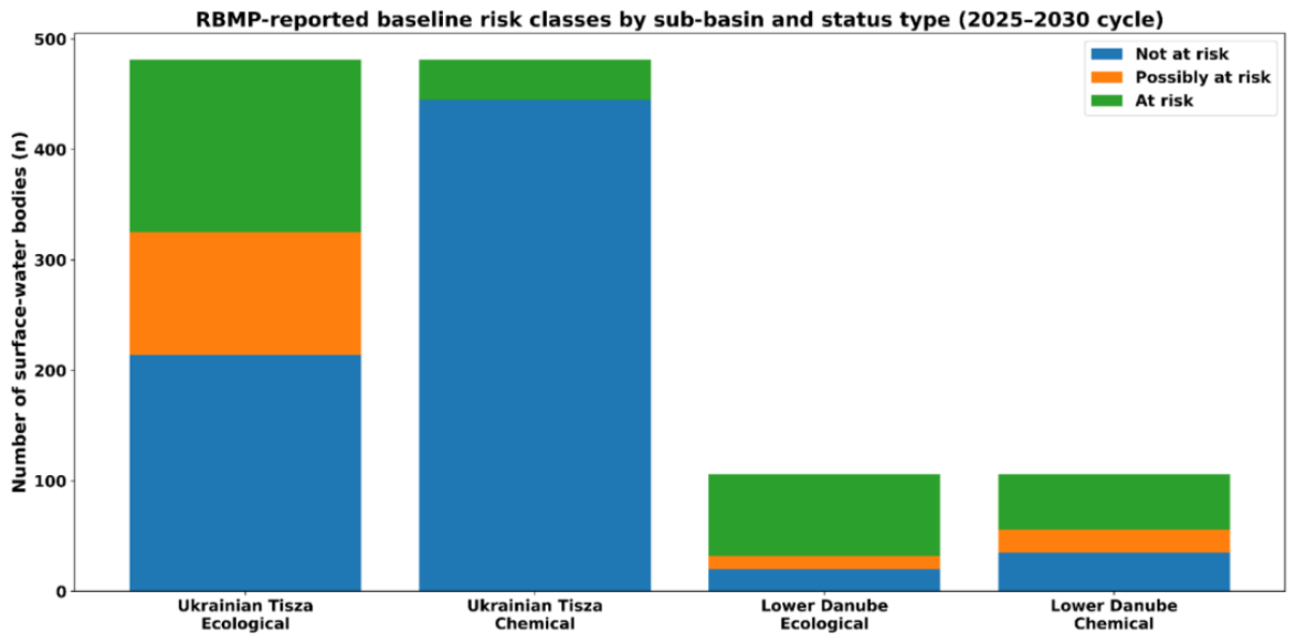
For the Lower Danube sub-basin, the baseline risk distribution is more constrained than in the Ukrainian Tisza sub-basin. For ecological status/potential, 20 surface-water bodies are reported as “not at risk”, 12 as “possibly at risk”, and 74 as “at risk”; for chemical status, 35 are “not at risk”, 21 are “possibly at risk”, and 50 are “at risk”. The plan anticipates 36 surface-water bodies reaching good ecological status/potential by 2030 [76]. Expressed as relative shares, the ecological baseline in the Ukrainian Tisza sub-basin corresponds to 44.5% not at risk, 23.1% possibly at risk, and 32.4% at risk, whereas the Lower Danube sub-basin shows 18.9%, 11.3%, and 69.8%, respectively. For chemical status, the Tisza sub-basin reports 92.5% not at risk and 7.5% at risk, while the Lower Danube reports 33.0% not at risk, 19.8% possibly at risk, and 47.2% at risk.
The RBMP-reported baseline distribution of surface-water bodies across risk classes for ecological status/potential and chemical status in the Ukrainian Tisza and Lower Danube sub-basins is summarised in Figure 7. The comparison highlights that the Ukrainian Tisza sub-basin has a larger “not at risk” baseline for chemical status, whereas the Lower Danube sub-basin shows higher shares of “at risk” classes for both ecological status/potential and chemical status, indicating a more constrained starting position under the same planning cycle [77]. In other words, the Lower Danube enters the 2025–2030 cycle from a markedly more constrained baseline-status position, whereas the Ukrainian Tisza combines a comparatively less adverse chemical baseline with stronger verification vulnerability linked to groundwater evidence discontinuity. This contrast supports the central argument of the paper: implementation difficulty cannot be inferred from ecological risk counts alone, but must be interpreted together with portfolio structure and evidence-chain continuity.

5. Discussion

This paper argues that, under war-driven high uncertainty, the binding constraint for WFD-aligned delivery is often not the ambition of the Programme of Measures, but the fragility of the implementation-and-verification chain that RBMPs implicitly assume. The Ukrainian Tisza case illustrates a portfolio that is pressure-relevant and policy-consistent, yet structurally exposed: the Programme of Measures is dominated by interventions that are typically multi-year and procurement- and coordination-intensive, and therefore sensitive to disruptions in financing, contractor availability, access conditions, and institutional continuity [78]. In such settings, technically sound measures can remain operationally “on paper” unless feasibility is treated as an explicit planning parameter rather than a contextual caveat.
A second insight is that feasibility is not only about construction capacity; it is also about whether progress can be credibly demonstrated within the planning cycle. The monitoring asymmetry reported for the baseline—operational surface-water monitoring versus a prolonged groundwater monitoring gap—creates a verification bottleneck. Consequently, some measures may be implemented but remain non-verifiable in outcome terms, which weakens adaptive management and, in transboundary settings, undermines upstream–downstream confidence [79]. This is particularly consequential for measures that require groundwater confirmation or rely on groundwater–surface water interactions: without an operational groundwater evidence chain, verification-grade reporting may default to process indicators or proxy metrics rather than outcome-based evaluation.
These findings support a practical shift from “what should be done” to “what can be delivered and verified first.” In high-uncertainty environments, RBMPs benefit from a verification-first sequencing logic that prioritises early-cycle actions which restore minimum evidential capacity (especially groundwater monitoring and documentation prerequisites) and unblock procurement- and coordination-intensive investments [80]. Where implementation is expected to start late in the cycle, delivery risk concentrates in a small number of high-cost, multi-actor measures that define an operational compliance critical path. Feasibility screening provides a transparent way to identify which measures require front-loaded project readiness (design documentation, permitting, procurement preparation, financing commitments) to avoid losing the limited window for measurable progress by 2030. In the Ukrainian Tisza case, this logic translates into a concrete wartime priority order. First, priority shifts towards maintaining essential water and wastewater functions in the largest municipal pressure nodes, because incomplete sanitation coverage and concentrated urban discharges create immediate public-health and environmental risks. Second, restoring a minimum monitoring and documentation chain becomes a priority in its own right, especially for groundwater-related measures, because without a workable evidence base, implementation may proceed but remain weakly verifiable. Third, the current PoM places stronger emphasis on reconstruction and upgrading of centralised municipal wastewater infrastructure than on a documented transition towards decentralised service models; under the present planning architecture, the wartime shift is therefore more clearly visible in the prioritisation of continuity, repair, and verification capacity than in any systemic redesign of service structure. The case also reveals several concrete trade-offs in implementation and financing. One trade-off lies between financing a small number of highly visible, capital-intensive municipal wastewater reconstructions and funding lower-cost enabling actions that restore monitoring, inventory, and verification capacity. The first group is represented by the compliance-critical shortlist, which comprises 10 measures with a cumulative reported cost of 4343.1 mln UAH, while the groundwater-linked evidence-constrained subset comprises 6 measures, four of which have reported costs totalling 43.981 mln UAH. A second trade-off lies between measures that can be verified more readily through the existing surface-water monitoring network and measures that may be strategically important for groundwater protection but remain weakly verifiable under current evidence constraints. A third trade-off concerns timing: concentrating scarce wartime implementation capacity on large multi-year projects may be justified by their environmental significance, yet it can also delay the lower-cost enabling actions needed to make later-cycle reporting credible. These tensions do not weaken the rationale for the PoM; rather, they clarify why prioritisation under wartime conditions must be understood as a sequence of constrained choices rather than as a purely technical ranking of environmental desirability.
The transboundary dimension amplifies the relevance of this approach. Headwater sub-basins such as the Tisza are upstream nodes where pressures—and the benefits of mitigation—propagate downstream. In multi-country basins, compliance credibility depends not only on whether measures are planned, but on whether they are verifiable under comparable evidence standards [81]. Making feasibility and evidence readiness explicit can therefore function as a trust-building layer in transboundary RBMP coordination: it clarifies what is realistically deliverable within the cycle and which evidence gaps must be closed to sustain comparability and shared compliance trajectories. These findings are broadly consistent with earlier studies showing that RBMP implementation often falters not because objectives are poorly formulated, but because delivery conditions, monitoring continuity, and institutional coordination are weaker than the planning architecture assumes. At the same time, the present study extends that literature in three ways. First, unlike studies that treat implementation barriers and monitoring adequacy as separate issues, it analyses them jointly through a measure-level framework linking expected environmental contribution, implementation dependency, and evidence readiness. Second, in contrast to work that focuses primarily on ecological status or pressure reduction, the present analysis shows that verification capacity itself can become a decisive bottleneck under war-driven uncertainty, particularly where groundwater monitoring is discontinuous. Third, compared with more general transboundary water-governance research, the study demonstrates that sub-basin difficulty cannot be inferred from baseline ecological risk alone: the Tisza case suggests that portfolio structure, delivery dependency, and evidence-chain continuity jointly shape the credibility of progress within a planning cycle. In this sense, the study complements previous RBMP and monitoring literature by shifting attention from whether measures are formally appropriate to whether they are realistically deliverable and verifiable under disrupted governance conditions.
A testable prediction follows directly from these results: RBMPs characterised by a high share of multi-year, dependency-heavy measures combined with monitoring evidence gaps will exhibit the largest divergence between planned implementation and verified outcomes by the end of the planning cycle. This hypothesis can be tested across sub-basins or planning cycles by comparing (i) the share of measures started or completed, (ii) procurement and financing execution rates, and (iii) the share of measures for which outcome-relevant monitoring remained available, and then examining whether portfolios with stronger dependency–evidence constraints exhibit larger gaps between reported implementation and verified status-relevant outcomes. The required inputs are available in principle from routinely reported RBMP implementation records, procurement and financing documentation, and monitoring coverage data, including contexts beyond armed conflict (e.g., fiscal shocks, extreme-event disruptions, or governance transitions) [82]. Framing feasibility and evidence readiness as explicit, testable determinants of RBMP effectiveness can help move the field from descriptive accounts of underperformance to a more predictive science of deliverability and verification readiness in basin planning.
The study has limitations. It is an ex ante assessment based on official documentary evidence and annex tables; expected contribution, dependency, and evidence readiness are derived from reported descriptors and structured proxies rather than from observed implementation outcomes [83]. However, this limitation is also the point: RBMPs are adopted as documentary programmes, and feasibility screening provides a transparent way to identify “where the plan may fail” before failures materialise. This is especially relevant in unstable environments, where official planning records may remain internally consistent while operational realities change more rapidly on the ground, creating a gap between documented implementation logic and actual delivery conditions. Future work should validate screening outputs against realised delivery outcomes, extend the benchmark across additional sub-basins, and refine verification-first sequencing rules for high-uncertainty environments to support WFD-consistent ambition under conditions where governance stability cannot be assumed.

6. Conclusions

This study shows that, under war-driven high uncertainty, WFD-oriented river basin planning is increasingly constrained not only by ecological ambition, but by the deliverability and verifiability of the Programme of Measures (PoM) within a single planning cycle. Using the Ukrainian Tisza sub-basin as a transboundary headwater case, we translated the RBMP narrative and Annex 11 PoM tables into a measure-level dataset and applied a feasibility-screening framework linking three dimensions: expected environmental contribution, implementation dependency, and evidence readiness for verification-grade reporting.
Three conclusions emerge. First, the PoM portfolio is dominated by multi-year, dependency-heavy measures, indicating that delivery risk concentrates in a relatively small subset of procurement- and coordination-intensive interventions. Second, verification readiness is structurally uneven: the documented groundwater evidence gap creates a bottleneck for groundwater-linked measures, limiting the ability to demonstrate outcomes even when implementation proceeds. Third, the within-plan benchmark suggests that baseline risk counts alone do not explain “difficulty”; rather, the divergence between planned and verified progress is shaped by the interaction between portfolio dependency structure and evidence-chain continuity. In a transboundary headwater basin, this directly affects upstream–downstream confidence and the credibility of shared compliance trajectories.
The key practical implication is a verification-first sequencing logic: early-cycle priorities should explicitly restore minimum monitoring and documentation prerequisites, front-load project readiness for critical investments, and focus on measures that define the compliance critical path. In the present case, this means giving priority to continuity of essential municipal water and wastewater services, restoration of minimum monitoring capacity, and a staged approach to high-cost investments whose environmental significance is high but whose delivery and verification are most exposed to wartime disruption. More broadly, the study advances a transferable proposition: RBMPs should be stress-tested for deliverability under high uncertainty. This proposition aligns with earlier work on implementation deficits, monitoring adequacy, and transboundary coordination, but adds a verification-oriented measure-level perspective that is particularly relevant in disrupted or crisis-affected governance settings. A testable prediction follows—basins combining a high share of multi-year measures with evidence gaps will exhibit the largest gap between planned implementation and verified outcomes by cycle end—creating a clear agenda for comparative research and policy learning.

Supplementary Materials

The following supporting information can be downloaded at: https://www.mdpi.com/article/10.3390/w18101178/s1, Supplementary Table S1. Codebook for variable harmonisation and feasibility-screening indicators used in the measure-level analysis of the Programme of Measures. Supplementary Figure S1. Structure of the measure-level analytical dataset and feasibility-screening outputs used in the study. The figure summarises the analytical logic linking documentary source descriptors, harmonised delivery and constraint variables, and the derived screening outputs used to identify evidence-constrained and compliance-critical measures in the Programme of Measures.

Author Contributions

Conceptualization, S.D., O.M. and S.L.; methodology, S.D. and S.V.; software, S.L. and S.D.; validation, O.M. and S.V.; formal analysis, S.L. and S.D.; investigation, O.M. and S.D.; resources, S.D. and O.M.; data curation, S.L. and S.V.; writing—original draft preparation, S.D. and S.V.; writing—review and editing, S.L. and S.D.; visualization, S.D. and S.V.; supervision, S.L., S.D. and O.M.; project administration, S.D. and S.V.; funding acquisition, S.L. All authors have read and agreed to the published version of the manuscript.

Funding

This research received no external funding.

Data Availability Statement

The original contributions presented in this study are included in the article/Supplementary Material. Further inquiries can be directed to the corresponding author.

Acknowledgments

The authors gratefully acknowledge the Basin Water Resources Management of the Tisza River (BUVRTysa) and the Centre for Interdisciplinary Research of Uzhhorod National University, Uzhhorod National University, 88000 Uzhhorod, Ukraine, for institutional support and assistance during the preparation of this study.

Conflicts of Interest

The authors declare no conflicts of interest.

References

  1. Basin Water Resources Management of the Tisza River. (2025–2030) (River Sub-Basin Management Plan for the Tisza (2025–2030)). Available online: https://buvrtysa.gov.ua/newsite/?page_id=18150 (accessed on 20 February 2026).
  2. Reese, M. Transformation to healthy water ecology—Institutional requirements, deficits and options in European and German perspective. Sustainability 2021, 13, 3368. [Google Scholar] [CrossRef]
  3. Starke, J.R.; Van Rijswick, H.F.M.W. Exemptions of the EU Water Framework Directive deterioration ban: Comparing implementation approaches in Lower Saxony and The Netherlands. Sustainability 2021, 13, 930. [Google Scholar] [CrossRef]
  4. Mandryk, O.; Pukish, A.; Zelmanovych, A. Formation peculiarities of physical and chemical composition of highly mineralized edge water. Min. Miner. Depos. 2017, 11, 72–79. [Google Scholar] [CrossRef][Green Version]
  5. Strokal, V. Transboundary rivers of Ukraine: Perspectives for sustainable development and clean water. J. Integr. Environ. Sci. 2021, 18, 67–87. [Google Scholar] [CrossRef]
  6. Uzhhorod City Council. General Plan of Uzhhorod 2023. Available online: https://rada-uzhgorod.gov.ua/media/2024/12/21/09-54-51_%D0%A3%D0%B6%D0%B3%D0%BE%D1%80%D0%BE%D0%B4_2023__%D0%93%D0%9F_.pdf (accessed on 20 February 2026).
  7. Yara, O.; Uliutina, O.; Golovko, L.; Andrushchenko, L. The EU Water Framework Directive: Challenges and prospects for im-plementation in Ukraine. Eur. J. Sustain. Dev. 2018, 7, 175–182. [Google Scholar] [CrossRef]
  8. OECD. OECD Water Governance Indicator Framework; OECD: Paris, France, 2021; Available online: https://www.oecd.org/content/dam/oecd/en/topics/policy-sub-issues/water-governance/oecd_water-governance-indicator-framework_en.pdf (accessed on 10 March 2026).
  9. Zasidko, I.; Polutrenko, M.; Mandryk, O.; Stakhmych, Y.; Petroshchuk, N. Complex technology of sewage purification from heavy-metal ions by natural adsorbents and utilization of sewage sludge. J. Ecol. Eng. 2019, 20, 209–216. [Google Scholar] [CrossRef] [PubMed]
  10. Santos, E. Reforming water governance: Nordic lessons for Southern Europe. Sustainability 2025, 17, 7079. [Google Scholar] [CrossRef]
  11. Kuznietsov, P.; Biedunkova, O.; Pryshchepa, A.; Mandryk, O. Modelling of open circuit cooling systems chemical emissions to river water via blowdown water and their impact on the quality of effluents discharged. Eng. Proc. 2025, 117, 22. [Google Scholar] [CrossRef]
  12. Lousada, S.; Gómez, J.M.N.; Vilčekova, S.; Delehan, S. Integrating resilient water infrastructure and environmental impact assessment in borderland river basins. Water 2025, 17, 1205. [Google Scholar] [CrossRef]
  13. Lousada, S.; Silva, P.S.d.; Castanho, R.A.; Naranjo-Gómez, J.M. Modelação de sistemas de abastecimento de água: O caso da Ilha da Madeira. Bitácora Urbano Territ. 2019, 29, 89–98. [Google Scholar] [CrossRef]
  14. International Commission for the Protection of the Danube River. Updated Integrated Tisza River Basin Management Plan 2019; ICPDR: Vienna, Austria, 2019; Available online: https://www.icpdr.org/sites/default/files/nodes/documents/updated_itrbmp_2019.pdf (accessed on 5 March 2026).
  15. Delehan-Kokaiko, S.; Glyudzyk, E.; Symkanuch, O. Integrated assessment of atmospheric air pollution by the example of the city of Uzhhorod (Ukraine). Technol. Audit. Prod. Reserv. 2021, 4, 27–31. [Google Scholar] [CrossRef]
  16. Pavlek, K.; Plantak, M.; Martinić, I.; Vinković, K.; Vučković, I.; Čanjevac, I. Methodological framework for assessing hydromorphological conditions of heavily modified and artificial river water bodies in Croatia. Water 2023, 15, 1113. [Google Scholar] [CrossRef]
  17. Voulvoulis, N.; Arpon, K.D.; Giakoumis, T. The EU Water Framework Directive: From great expectations to problems with implementation. Sci. Total Environ. 2017, 575, 358–366. [Google Scholar] [CrossRef] [PubMed]
  18. European Commission. Ukraine Report 2025; European Commission: Brussels, Belgium, 2025; Available online: https://enlargement.ec.europa.eu/document/download/17115494-8122-4d10-8a06-2cf275eecde7_en?filename=ukraine-report-2025.pdf (accessed on 20 March 2026).
  19. Cabinet of Ministers of Ukraine. Order No. 1347-r on Approval of the Danube River Basin Management Plan for 2025–2030; Cabinet of Ministers of Ukraine: Kyiv, Ukraine, 2024. Available online: https://zakon.rada.gov.ua/laws/show/1347-2024-%D1%80 (accessed on 20 March 2026).
  20. State Agency of Water Resources of Ukraine. Programme of Measures for the Tisza Sub-Basin (Danube River Basin Management Plan 2025–2030, Annexed Measure Table). 2025. Available online: https://davr.gov.ua/fls18/PoM_Tisza_final.xlsx (accessed on 20 March 2026).
  21. Milman, A.; Gerlak, A.K.; Albrecht, T.; Colosimo, M.; Conca, K.; Kittikhoun, A.; Kovács, P.; Moy, R.; Schmeier, S.; Wentling, K.; et al. Addressing knowledge gaps for transboundary environmental governance. Glob. Environ. Change 2020, 64, 102162. [Google Scholar] [CrossRef]
  22. Shumilova, O.; Tockner, K.; Sukhodolov, A.; Khilchevskyi, V.; de Meester, L.; Stepanenko, S.; Trokhymenko, G.; Hernández-Agüero, J.A.; Gleick, P. Impact of the Russia–Ukraine armed conflict on water resources and water infrastructure. Nat. Sustain. 2023, 6, 578–586. [Google Scholar] [CrossRef]
  23. Pahl-Wostl, C.; Lebel, L.; Knieper, C.; Nikitina, E. From applying panaceas to mastering complexity: Toward adaptive water governance in river basins. Environ. Sci. Policy 2012, 23, 24–34. [Google Scholar] [CrossRef]
  24. Snizhko, S.; Didovets, I.; Bronstert, A. Ukraine’s water security under pressure: Climate change and wartime. Water Secur. 2024, 23, 100182. [Google Scholar] [CrossRef]
  25. Dari, J.; Filippucci, P.; Brocca, L. The development of an operational system for estimating irrigation water use reveals socio-political dynamics in Ukraine. Hydrol. Earth Syst. Sci. 2024, 28, 2651–2659. [Google Scholar] [CrossRef]
  26. Hering, D.; Borja, A.; Carstensen, J.; Carvalho, L.; Elliott, M.; Feld, C.K.; Heiskanen, A.-S.; Johnson, R.K.; Moe, J.; Pont, D.; et al. The European Water Framework Directive at the age of 10: A critical review of the achievements with recommendations for the future. Sci. Total Environ. 2010, 408, 4007–4019. [Google Scholar] [CrossRef]
  27. Kuryltsiv, R.; Stańczuk-Gałwiaczek, M.; Łuczyński, R. Water user associations in drained and irrigated areas for more sustainable land and water management: Experiences from Poland and Ukraine. Sustainability 2025, 17, 7100. [Google Scholar] [CrossRef]
  28. Carvalho, L.; Mackay, E.B.; Cardoso, A.C.; Baattrup-Pedersen, A.; Birk, S.; Blackstock, K.L.; Borics, G.; Borja, A.; Feld, C.K.; Ferreira, M.T.; et al. Protecting and restoring Europe’s waters: An analysis of the future development needs of the Water Framework Directive. Sci. Total Environ. 2019, 658, 1228–1238. [Google Scholar] [CrossRef] [PubMed]
  29. Binh, N.T.; Samberger, C.; Nhi, T.T.A.; Tu, N.M.; Tien, L.V.T.; Minh, L.B.N.; Quan, N.H. Sustainable consumption and production from water circularity perspectives (SDG 12). In Water Matters: Achieving the Sustainable Development Goals; Mukherjee, A., Ed.; Elsevier: Amsterdam, The Netherlands, 2024; pp. 247–260. [Google Scholar] [CrossRef]
  30. Pinto, I.; Azevedo, L.; Antunes, S.C. Changes in regional practices and their effects on the water quality of Portuguese reservoirs. Earth 2025, 6, 29. [Google Scholar] [CrossRef]
  31. Chapman, D.V.; Bradley, C.; Gettel, G.M.; Hatvani, I.G.; Hein, T.; Kovács, J.; Liska, I.; Oliver, D.M.; Tanos, P.; Trásy, B.; et al. Developments in water quality monitoring and management in large river catchments using the Danube River as an example. Environ. Sci. Policy 2016, 64, 141–154. [Google Scholar] [CrossRef]
  32. Collins, A.; Ohandja, D.-G.; Hoare, D.; Voulvoulis, N. Implementing the Water Framework Directive: A transition from established monitoring networks in England and Wales. Environ. Sci. Policy 2012, 17, 49–61. [Google Scholar] [CrossRef]
  33. Raadgever, G.T.; Dieperink, C.; Driessen, P.P.J.; Smit, A.A.H.; van Rijswick, H.F.M.W. Uncertainty management strategies: Lessons from the regional implementation of the Water Framework Directive in the Netherlands. Environ. Sci. Policy 2011, 14, 64–75. [Google Scholar] [CrossRef]
  34. Hussein, H.; Menga, F.; Greco, F. Monitoring transboundary water cooperation in SDG 6.5.2: How a critical hydropolitics approach can spot inequitable outcomes. Sustainability 2018, 10, 3640. [Google Scholar] [CrossRef]
  35. Mukherjee, A.; Dash, A.A. Water matters: The thirst, the demand, and the society. In Water Matters: Achieving the Sustainable Development Goals; Mukherjee, A., Ed.; Elsevier: Amsterdam, The Netherlands, 2024; pp. 3–11. [Google Scholar] [CrossRef]
  36. Javed, A.; Gul, I.; Rizwan, W. Conservation of water ecosystem (SDG 14). In Water Matters: Achieving the Sustainable Development Goals; Mukherjee, A., Ed.; Elsevier: Amsterdam, The Netherlands, 2024; pp. 285–293. [Google Scholar] [CrossRef]
  37. State Agency of Water Resources of Ukraine. Danube River Basin Management Plan 2025–2030: Official Resource with Annexed Programme of Measures Tables for the Tisza, Prut and Siret, and Lower Danube Sub-Basins. 2025. Available online: https://davr.gov.ua/plan-upravlinnya-richkovim-basejnom-dunayu1 (accessed on 16 March 2026).
  38. Klauer, B.; Sigel, K.; Schiller, J. Disproportionate costs in the EU Water Framework Directive—How to justify less stringent environmental objectives. Environ. Sci. Policy 2016, 59, 10–17. [Google Scholar] [CrossRef]
  39. Manzoni, A.; Hamam, M.; Pastorelli, G.; Servadei, L.; Chiappini, S.; Pesce, A.; Tarangioli, S.; Pergamo, R. The EU Nature Restoration Law (NRL) and the Common Agricultural Policy (CAP): State of the art and future challenges for Italian water resources. Land 2025, 14, 987. [Google Scholar] [CrossRef]
  40. Salamanca-Cano, A.K.; Durán-Díaz, P. Stakeholder engagement around water governance: 30 years of decision-making in the Bogotá River Basin. Urban Sci. 2023, 7, 81. [Google Scholar] [CrossRef]
  41. Junier, S.; Mostert, E. A decision support system for the implementation of the Water Framework Directive in the Netherlands: Process, validity and useful information. Environ. Sci. Policy 2014, 40, 49–56. [Google Scholar] [CrossRef]
  42. Bytsyura, L.; Szczepanik-Scislo, N.; Desyatnyuk, O.; Shakhovska, N.; Scislo, L.; Sachenko, A.; Lototska, O.; Shevchuk, I.; Sofinska, O. Research on surface water state for rivers in Western Ukraine using time series forecasting methods. Water 2025, 17, 3148. [Google Scholar] [CrossRef]
  43. UNEP-DHI Centre on Water and Environment. IWRM Data Portal. Available online: https://iwrmdataportal.unepdhi.org/ (accessed on 20 February 2026).
  44. Delehan, S.; Melehanych, H. Environmental and energy security on the way to rebuilding Ukraine on the principle of zero carbon footprint. In Ukraine’s Journey to Recovery, Reform and Post-War Reconstruction; Nate, S., Ed.; Contributions to Security and Defence Studies; Springer: Cham, Switzerland, 2025. [Google Scholar] [CrossRef]
  45. Delehan, S.; Malychkovych, O.; Melehanych, H. Study of the state of environmental information security of Ukraine in the pre-war period and assessment of the consequences of environmental information manipulations in view of changes in the geopolitical landscape and new strategic risks. In Ukraine’s Journey to Recovery, Reform and Post-War Reconstruction; Nate, S., Ed.; Contributions to Security and Defence Studies; Springer: Cham, Switzerland, 2025. [Google Scholar] [CrossRef]
  46. Ministry of Environmental Protection and Natural Resources of Ukraine. River Basin Management Plans 2025–2030. 2025. Available online: https://mepr.gov.ua/diyalnist/plany/plany-upravlinnya-richkovymy-basejnamy-2025-2030-roky/ (accessed on 20 February 2026).
  47. Kochskämper, E.; Challies, E.; Newig, J.; Jager, N.W. Participation for effective environmental governance? Evidence from Water Framework Directive implementation in Germany, Spain and the United Kingdom. J. Environ. Manag. 2016, 181, 737–748. [Google Scholar] [CrossRef] [PubMed]
  48. Cabinet of Ministers of Ukraine. Resolution No. 1134 of 9 December 2022 on Approval of the Water Strategy of Ukraine for the Period up to 2050. Available online: https://zakon.rada.gov.ua/laws/show/1134-2022-%D1%80#Text (accessed on 20 February 2026).
  49. Ministry of Ecology and Natural Resources of Ukraine. Order No. 4 of 14 January 2019 on Approval of the Methodology for Determining Surface and Groundwater Bodies. Available online: https://zakon.rada.gov.ua/laws/show/z0287-19#Text (accessed on 20 February 2026).
  50. Ministry of Ecology and Natural Resources of Ukraine. Order No. 5 of 14 January 2019 on Approval of the Methodology for Assigning a Surface Water Body to Ecological and Chemical Status Classes and an Artificial or Heavily Modified Surface Water Body to Ecological Potential Classes. Available online: https://zakon.rada.gov.ua/laws/show/z0127-19#Text (accessed on 20 February 2026).
  51. Cabinet of Ministers of Ukraine. Resolution No. 758 of 19 September 2018 on Approval of the Procedure for State Water Monitoring. Available online: https://zakon.rada.gov.ua/laws/show/758-2018-%D0%BF#Text (accessed on 20 February 2026).
  52. Association of Water Utilities of Ukraine. The Critical State of Water Supply and Drainage Enterprises of Ukraine in the Conditions of Uncertainty of Sources of Financing of Enterprises. 2024. Available online: https://ukrvodokanal.in.ua/vidbulas-pres-konferentsiya-krytychnyj-stan-pidpryyemstv-vodopostachannya-ta-vodovidvedennya-ukrayiny-v-umovah-nevyznachenosti-dzherel-finansuvannya-pidpryyemstv/ (accessed on 20 February 2026).
  53. Ministry of Environmental Protection and Natural Resources of Ukraine. Digests of the Key Consequences of Russian Aggression for the Ukrainian Environment. 2024. Available online: https://ecozagroza.gov.ua/ (accessed on 20 February 2026).
  54. García, L.E.; Rodríguez, D.J.; Wijnen, M.; Pakulski, I. (Eds.) Earth Observation for Water Resources Management: Current Use and Future Opportunities for the Water Sector; World Bank: Washington, DC, USA, 2016. [Google Scholar] [CrossRef]
  55. Michalakis, I.; Loupasakis, C.; Tsolaki, E. Groundwater overexploitation and land subsidence in the Messara Basin, Crete: Integrating land use, hydrolithology and basin-scale potentiometry with InSAR. Land 2025, 14, 2124. [Google Scholar] [CrossRef]
  56. Prniyazova, A.; Turaeva, S.; Turgunov, D.; Jarihani, B. Sustainable transboundary water governance in Central Asia: Challenges, conflicts, and regional cooperation. Sustainability 2025, 17, 4968. [Google Scholar] [CrossRef]
  57. United Nations Economic Commission for Europe. Updated Strategies for Monitoring and Assessment of Transboundary Rivers, Lakes and Groundwaters; United Nations: Geneva, Switzerland, 2022; Available online: https://unece.org/sites/default/files/2022-04/Strategies_updated_21_March_2022_ENG%20_0.pdf (accessed on 12 March 2026).
  58. Makarenko, N.A.; Strokal, V.P.; Berezhniak, Y.M.; Bondar, V.I.; Pavliuk, S.D.; Vagaliuk, L.V.; Naumovska, O.I.; Ladyka, M.M.; Kovpak, A.V. Vplyv rosiiskoi voiennoi ahresii na pryrodni resursy Ukrainy: Analiz sytuatsii, metodolohiia otsiniuvannia (The war consequences on natural resources of Ukraine: Analyses and methodologies). Sci. Rep. Natl. Univ. Life Environ. Sci. Ukr. 2022, 18, 4. (In Ukrainian) [Google Scholar] [CrossRef]
  59. Lopes, P.D.; Gama, M. Reviewing water wars and water weaponisation literatures: Is there an unnoticed link? Water 2025, 17, 897. [Google Scholar] [CrossRef]
  60. González del Tánago, M.; Martínez-Fernández, V.; Aguiar, F.C.; Bertoldi, W.; Dufour, S.; García de Jalón, D.; Garófano-Gómez, V.; Mandzukovski, D.; Rodríguez-González, P.M. Improving river hydromorphological assessment through better integration of riparian vegetation: Scientific evidence and guidelines. J. Environ. Manag. 2021, 292, 112730. [Google Scholar] [CrossRef]
  61. Mentzafou, A.; Katsafados, P.; Papadopoulos, A.; Dimitriou, E. Hydrological regime alteration assessment in the context of WFD 2000/60: A European and global review. Sustainability 2023, 15, 15704. [Google Scholar] [CrossRef]
  62. Cabinet of Ministers of Ukraine. Resolution No. 1071 of 6 September 2024 on Amendments to Certain Resolutions of the Cabinet of Ministers of Ukraine on Water Monitoring. Available online: https://zakon.rada.gov.ua/laws/show/1071-2024-%D0%BF#Text (accessed on 20 February 2026).
  63. Delehan, S.; Vilčeková, S.; Melehanych, H.; Krídlová Burdová, E.; Khorolskyi, A. A comparative assessment of the capabilities and success of the wood construction industry in Slovakia and Ukraine based on life cycle assessment certification standards. Front. Environ. Sci. 2024, 12, 1319823. [Google Scholar] [CrossRef]
  64. Malinauskaite, J.; Delpech, B.; Montorsi, L.; Venturelli, M.; Gernjak, W.; Abily, M.; Stepišnik Perdih, T.; Nyktari, E.; Jouhara, H. Wastewater reuse in the EU and Southern European countries: Policies, barriers and good practices. Sustainability 2024, 16, 11277. [Google Scholar] [CrossRef]
  65. OECD. Toolkit for Water Policies and Governance: Converging Towards the OECD Council Recommendation on Water; OECD Publishing: Paris, France, 2021; Available online: https://www.oecd.org/content/dam/oecd/en/publications/reports/2021/03/toolkit-for-water-policies-and-governance_783de7b0/ed1a7936-en.pdf (accessed on 10 March 2026).
  66. Farlin, J.; Gallé, T.; Pittois, D.; Bayerle, M.; Schaul, T. Groundwater quality monitoring network design and optimisation based on measured contaminant concentration and taking solute transit time into account. J. Hydrol. 2019, 573, 516–523. [Google Scholar] [CrossRef]
  67. Ohmer, M.; Liesch, T.; Wunsch, A. Spatiotemporal optimization of groundwater monitoring networks using data-driven sparse sensing methods. Hydrol. Earth Syst. Sci. 2022, 26, 4033–4053. [Google Scholar] [CrossRef]
  68. Hapich, H.; Novitskyi, R.; Onopriienko, D.; Dent, D.; Roubik, H. Water security consequences of the Russia-Ukraine war and the post-war outlook. Water Secur. 2024, 21, 100167. [Google Scholar] [CrossRef]
  69. Khilchevskyi, V.K. Vodni ta zbroini konflikty—Klasyfikatsiini oznaky: U sviti ta v Ukraini (Water and armed conflicts—Classification features: In the world and in Ukraine). Hydrol. Hydrochem. Hydroecol. 2022, 1, 6–19. (In Ukrainian) [Google Scholar] [CrossRef]
  70. Giakoumis, T.; Voulvoulis, N. Water Framework Directive programmes of measures: Lessons from the 1st planning cycle of a catchment in England. Sci. Total Environ. 2019, 668, 903–916. [Google Scholar] [CrossRef]
  71. State Agency of Water Resources of Ukraine. Metodychni Rekomendatsii Shchodo Vstanovlennia Ekolohichnykh Tsilei, Rozroblennia Prohramy Zakhodiv ta Vykonannia Analizu Ekonomichnoi Efektyvnosti Prohramy Zakhodiv Planu Upravlinnia Richkovym Baseinom (Methodological Recommendations for RBMP Environmental Objectives, Programme of Measures, and Cost-Effectiveness Analysis). 2023. Available online: https://davr.gov.ua/fls18/_pzz.pdf (accessed on 20 February 2026).
  72. Bryła, M.; Zdralewicz, I.; Lejcuś, I.; Kraj, K.; Dumieński, G.; Tokarczyk, T.; Walczykiewicz, T. Integrated water resources management for implementing sustainable energy development—Challenges and perspectives in Poland. Sustainability 2025, 17, 1169. [Google Scholar] [CrossRef]
  73. Bezdan, A.; Bezdan, J. Development of an adapted water quality index for the Danube River using objective weighting methods. Hydrology 2025, 12, 329. [Google Scholar] [CrossRef]
  74. Aydi, S.; Paredes-Arquiola, J.; Bergillos, R.J.; Solera, A.; Andreu, J. A pressure-impact approach to assess contamination and risk in surface water bodies. Hydrology 2025, 12, 301. [Google Scholar] [CrossRef]
  75. Janson, E.K.; Hamerla, A. Challenges of sustainable water management in a heavily industrialized urban basin: Case of Bytomka River, Poland. Sustainability 2025, 17, 5707. [Google Scholar] [CrossRef]
  76. Gleick, P.; Vyshnevskyi, V.; Shevchuk, S. Rivers and water systems as weapons and casualties of the Russia-Ukraine war. Earth’s Future 2023, 11, e2023EF003910. [Google Scholar] [CrossRef]
  77. Zheng, Y.; He, J.; Zhang, W.; Lv, A. Assessing water security and coupling coordination in the Lancang–Mekong River Basin for sustainable development. Sustainability 2023, 15, 16880. [Google Scholar] [CrossRef]
  78. Perra, V.-M.; Boile, M. Developing a monitoring and evaluation framework for sustainable maritime spatial planning: A stakeholder-driven approach. Sustainability 2025, 17, 5813. [Google Scholar] [CrossRef]
  79. Khilchevskyi, V.K.; Grebin, V.V. Deiaki aspekty shchodo stanu terytorii raioniv richkovykh baseiniv ta monitorynhu vod pid chas vtorhnennia Rosii v Ukrainu (2022 r.) (Some aspects regarding the state of the territory of river basin districts and water monitoring during Russia’s invasion of Ukraine (2022)). Hydrol. Hydrochem. Hydroecol. 2022, 3, 6–14. (In Ukrainian) [Google Scholar] [CrossRef]
  80. Strokal, V.P.; Kovpak, A.V. Viiskovi konflikty ta voda: Naslidky ta ryzyky (Military conflicts and water: Consequences and risks). Sci. J. Ecol. Sci. 2022, 5, 94–102. (In Ukrainian) [Google Scholar] [CrossRef]
  81. European Parliament; Council of the European Union. Directive (EU) 2024/3019 Concerning Urban Wastewater Treatment (recast). Off. J. Eur. Union 2024. Available online: https://eur-lex.europa.eu/eli/dir/2024/3019/oj/eng (accessed on 20 February 2026).
  82. European Parliament; Council of the European Union. Regulation (EU) 2024/1991 on Nature Restoration and Amending Regulation (EU) 2022/869. Off. J. Eur. Union 2024. Available online: https://eur-lex.europa.eu/eli/reg/2024/1991/oj/eng (accessed on 20 February 2026).
  83. Zhukova, O.; Starzhynskyi, P. Viina ta yii naslidky dlia poverkhnevykh vodoim (War and its consequences for surface water bodies). Environ. Prot. Technol. 2025, 42, 163–168. (In Ukrainian) [Google Scholar] [CrossRef]
Figure 1. Baseline planning and monitoring conditions in the Ukrainian Tisza sub-basin: (a) delineated surface-water management units; (b) surface-water monitoring coverage in 2023; and (c) groundwater evidence constraints relevant to verification during the 2025–2030 planning cycle.
Water 18 01178 g001
Figure 2. Research workflow and feasibility-screening methodology used to assess the deliverability of the 2025–2030 Programme of Measures in the Ukrainian Tisza sub-basin under war-driven uncertainty.
Water 18 01178 g002
Figure 3. Spatial distribution of RBMP-reported risk classes for achieving good ecological status/potential in the Ukrainian Tisza sub-basin (2025–2030 planning baseline). Surface-water bodies are classified as not at risk (green), possibly at risk (yellow), or at risk (red). Adapted from the Danube River Basin Management Plan 2025–2030 map materials for the Tisza sub-basin.
Water 18 01178 g003
Figure 4. Programme of Measures portfolio in the Ukrainian Tisza sub-basin (n = 120) grouped by Annex 11 section codes and showing the distribution of core and additional measures. Codes denote thematic measure blocks in the annex table: 8.1.1–8.1.3—pollution control measures (organic substances, nutrients, and hazardous substances); 8.1.4–8.1.5—hydromorphology and connectivity measures (including river continuity/floodplain-related actions); 8.2—groundwater measures; 8.3—other and enabling measures (planning, monitoring-related or administrative actions).
Water 18 01178 g004
Figure 5. Reported cost-class structure of the Tisza Programme of Measures (n = 120) by category group (low/medium/high; and measures with costs not reported).
Water 18 01178 g005
Figure 6. Delivery horizon structure of the Tisza Programme of Measures (n = 120) by category group, distinguishing single-date versus multi-year measures.
Water 18 01178 g006
Figure 7. RBMP-reported baseline distribution of surface-water bodies across risk classes for ecological status/potential and chemical status in the Ukrainian Tisza and Lower Danube sub-basins (2025–2030 planning cycle). Bars show counts classified as not at risk, possibly at risk, and at risk. For chemical status in the Ukrainian Tisza sub-basin, the “possibly at risk” class is not reported in the summary values used here and is plotted as zero.
Water 18 01178 g007
Table 1. Variable structure used for dataset construction.
Variable GroupDocumentary Fields Used from Annex TablesAnalytical Purpose
Pressure and objective linkageMain water–environmental problem; measure type; measure title/description; technical specificationTo identify the environmental pressure pathway addressed by each measure and its expected contribution to pressure reduction or status improvement
Spatial linkageRiver basin district; sub-basin; oblast; district; territorial community; management-unit category; management-unit codeTo connect each measure to its spatial and administrative setting and to the targeted management units
Implementation attributesResponsible organisations; implementation period; funding sources; restoration-of-war-damage field; commentsTo characterise delivery conditions, coordination requirements, implementation horizon, and potential war-relevant dependencies
Cost and scale proxiesPopulation affected; physical implementation units; investment costs; operation and maintenance costs; total costsTo approximate implementation scale, capital intensity, and potential delivery complexity
Disclaimer/Publisher’s Note: The statements, opinions and data contained in all publications are solely those of the individual author(s) and contributor(s) and not of MDPI and/or the editor(s). MDPI and/or the editor(s) disclaim responsibility for any injury to people or property resulting from any ideas, methods, instructions or products referred to in the content.