1. Introduction
Karst aquifers play a vital role in global freshwater supply, serving as crucial sources of drinking water for approximately one-quarter of the world’s population [
1,
2,
3]. Due to their unique hydrogeological properties, including high permeability, dual porosity, and strong heterogeneity, karst systems can store and transmit large quantities of groundwater through both diffuse and conduit flow mechanisms. Globally, approximately 15.2% of the ice-free land surface is underlain by carbonate rocks, with karst regions most extensive in China, which has both the largest absolute karst area (2.54 million km
2) and the highest national percentage (26.5%) among major countries [
3,
4,
5,
6]. However, the same complex structure that makes karst aquifers efficient water suppliers also poses significant challenges for understanding their hydrodynamics. Subsurface heterogeneity, rapid and localized recharge events, and poorly constrained flow paths often make it difficult to characterize the recharge, flow, and discharge processes within these systems [
7,
8,
9]. As a result, the scientific community still faces considerable uncertainty in modeling and managing karst groundwater resources, particularly under conditions of increasing anthropogenic stress and climate variability [
4,
10,
11].
Numerous methods have been developed to investigate karst groundwater systems, reflecting their inherent complexity and heterogeneity [
12,
13,
14,
15,
16]. At the foundational level, conventional hydrogeological techniques are widely applied, including monitoring groundwater level fluctuations, conducting pumping tests, performing water balance calculations, and analyzing karst spring discharge responses to precipitation [
17,
18,
19]. While these approaches are effective for identifying fundamental hydrological relationships and characterizing the temporal dynamics of groundwater systems, they largely remain at the stage of empirical observation and phenomenological description.
To progress from empirical observation to a process-based understanding of the hydrological cycle, isotopic and geochemical tracers are now widely employed. Stable isotopes (δ
2H, δ
18O) delineate recharge sources and quantify mixing between water masses [
20,
21,
22], whereas radiogenic strontium ratios (
87Sr/
86Sr) elucidate water–rock interaction and the evolution of flow paths [
23,
24]. Radioactive tracers such as
3H and
14C provide groundwater residence times [
25,
26], thereby constraining potential flow pathways. Collectively, these methods have greatly advanced the mechanistic understanding of karst aquifers, allowing researchers to resolve flow connectivity, residence times, and recharge processes with enhanced precision. In parallel, a suite of non-invasive techniques is now employed to resolve the internal architecture of karst media. These techniques, including electrical resistivity tomography, seismic imaging [
27], distributed temperature sensing [
28], and hydraulic tomography [
29], have been employed to explore the internal hydraulic architecture of karst systems. These techniques are especially valuable in delineating preferential flow paths, identifying conduit networks, and estimating permeability heterogeneity, thus providing a spatially resolved picture of subsurface hydrological structure.
Building on this foundation, numerical modeling has become an essential tool for the quantitative analysis of karst groundwater systems. Depending on the complexity of the conceptual model and data availability, researchers may employ equivalent porous media models [
30], dual-porosity or dual-permeability approaches, and discrete fracture or conduit flow models [
31,
32]. These models integrate multi-source observations and allow for scenario testing under changing environmental or anthropogenic conditions. Despite these methodological advances, the comprehensive and systematic characterization of karst groundwater systems remains a formidable challenge. The intrinsic spatial heterogeneity and dynamic behavior of karst environments demand integrative, multi-method frameworks that combine observation, process inference, structural imaging, and predictive modeling [
16].
The Yuquan Mountain (YM) karst groundwater system, located in the western part of Beijing, China, represents a typical karst system with both scientific significance and practical importance. Historically, the YM Spring was one of the most important natural springs in Beijing, supplying high-quality water to urban residents and supporting local ecosystems. As early as the Qing Dynasty, the spring was incorporated into imperial garden designs [
33], and throughout the 20th century, it contributed meaningfully to municipal water use. However, since 1975, the spring has experienced complete flow cessation due to intensive groundwater extraction and declining recharge, and has not naturally resumed flow since then [
34]. The disappearance of the spring has had negative consequences for local ecological conservation, urban water security, and public heritage values. Moreover, the lack of a comprehensive understanding of the hydrogeological framework and groundwater flow dynamics in the region limits the potential for scientifically informed management or possible spring recovery strategies. Given the importance of the spring to both the Beijing metropolitan area and the broader ecological function of the Beijing–Tianjin–Hebei region (North China), there is an urgent need to systematically integrate existing knowledge and identify knowledge gaps.
This paper aims to provide a comprehensive review of hydrogeological studies conducted in the YM karst groundwater system, with the goal of synthesizing current knowledge on recharge sources, groundwater flow patterns, and subsurface structure. By reviewing published data from water balance analysis, stable and radiogenic isotopes, major ion chemistry, geophysical surveys, and groundwater age studies, we propose an updated conceptual model of groundwater flow in the region. Furthermore, we critically assess the limitations of existing investigations and highlight key directions for future research, including the need for integrated monitoring networks, advanced modeling approaches, and consideration of artificial recharge scenarios. This review not only deepens scientific understanding of the YM Spring system and lays a foundation for subsequent hydrogeological and ecological restoration efforts, but also advances a transferable framework for studying and managing large karst springs elsewhere in northern China and analogous karst systems worldwide.
3. Recharge Mechanisms of Karst Groundwater
Understanding the recharge mechanisms of karst groundwater systems is essential for accurately characterizing aquifer dynamics and managing water resources. A variety of approaches have been developed to investigate recharge processes, ranging from conventional water balance calculations to advanced geochemical and isotopic tracing methods [
41,
42]. The water balance approach estimates the quantitative contribution of various potential recharge sources—such as precipitation, river infiltration, and lateral inflow—by analyzing input-output relationships across defined hydrological boundaries. In parallel, hydrochemical and isotopic indicators offer powerful tools to identify and distinguish recharge sources, assess recharge pathways, and constrain residence times within the aquifer system. Therefore, it is valuable to combine these methodological perspectives in order to evaluate the key recharge sources that sustain the YM karst groundwater system.
3.1. Quantifying Recharge from Precipitation and River Leakage via Water Balance Calculations
The YM karst groundwater system encompasses several stratigraphic aquifer units, including the Jixian, Cambrian, and Ordovician formations [
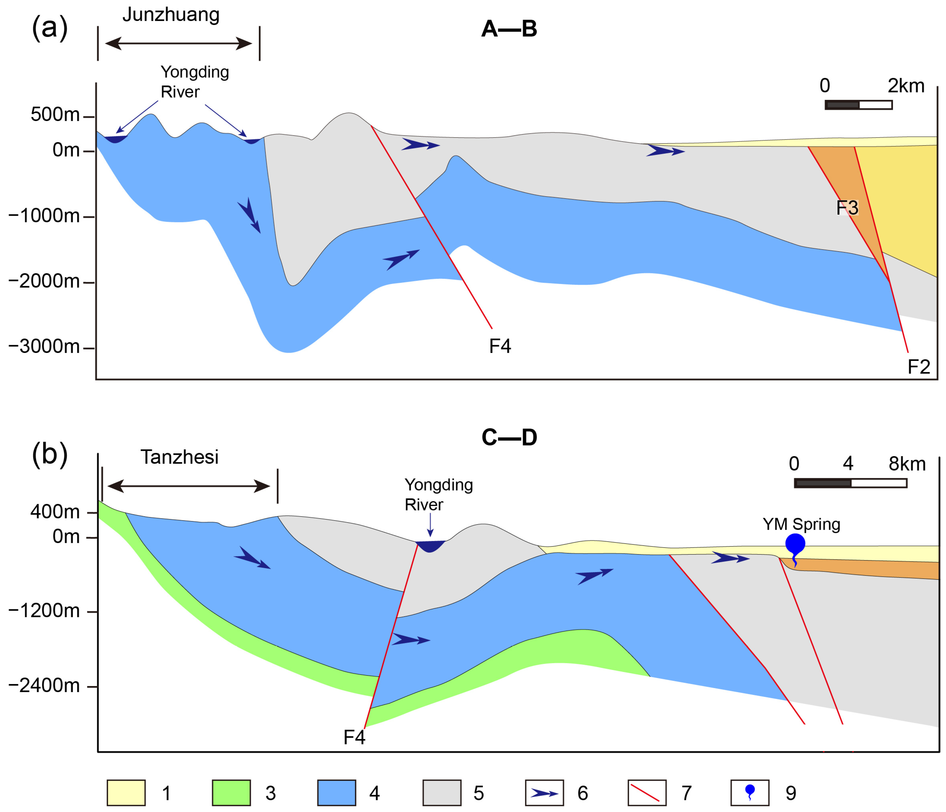
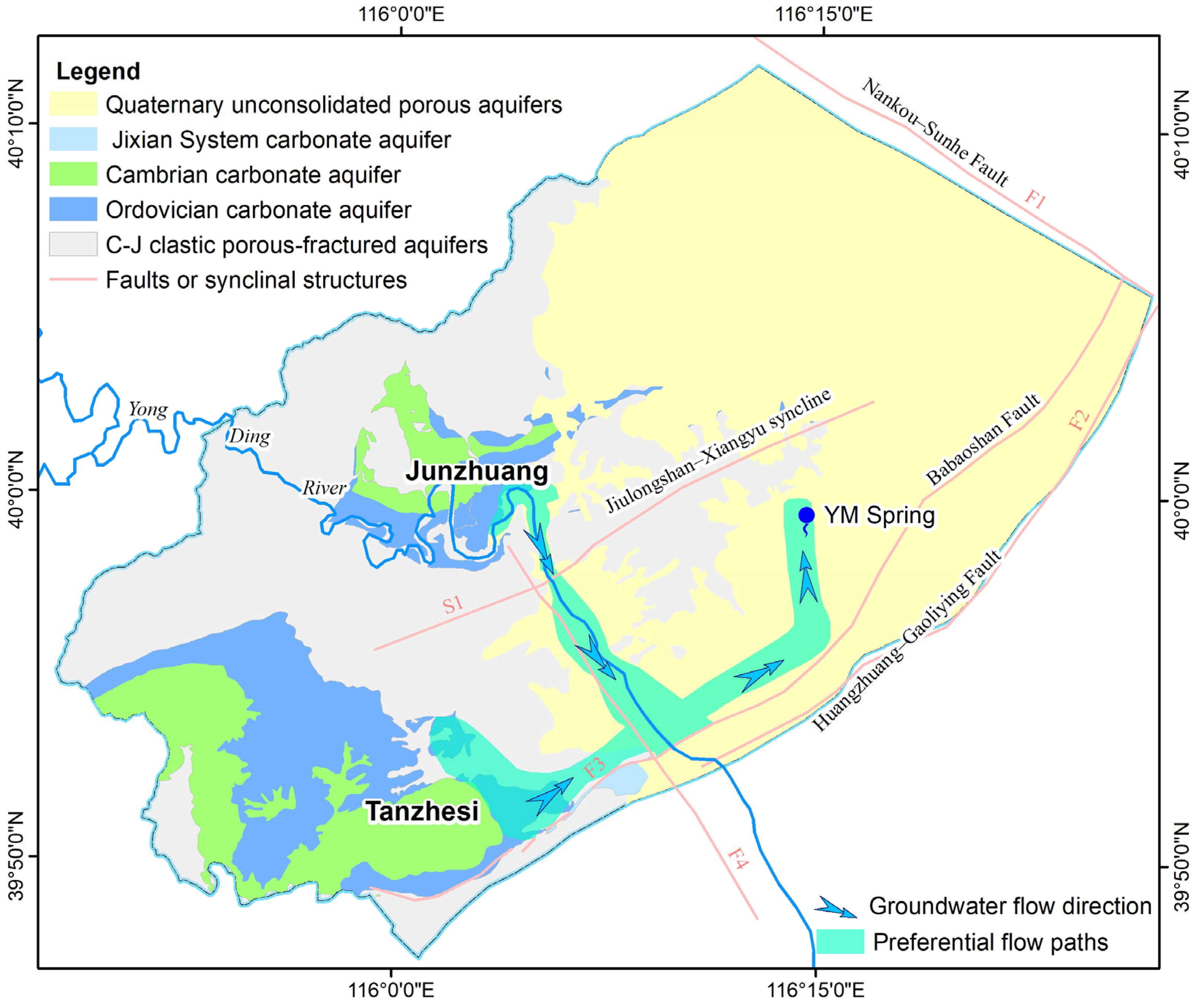
23]. Among these, the Ordovician limestone formations are widely exposed in areas such as Tanzhesi and Junzhuang (
Figure 1), where well-developed karst fractures and conduits offer favorable conditions for the infiltration of local precipitation and Yongding River water. A comparative analysis of groundwater level fluctuations in observation wells and local precipitation records in these exposed zones reveals a clear hydraulic linkage. Wang et al. [
43] reported that peak groundwater levels in the Ordovician aquifer typically lag behind peak rainfall events by approximately 40 days. This relatively short delay highlights a significant recharge response, indicating that direct infiltration of precipitation is a major contributor to groundwater recharge in the exposed limestone areas of Tanzhesi and Junzhuang (
Figure 1).
To quantify the contribution of these exposed limestone zones to the recharge of the YM karst aquifer system, a preliminary estimation was conducted using the infiltration coefficient method. This approach integrates spatial data on exposed karst areas, long-term precipitation statistics, and site-specific infiltration coefficients to assess annual recharge volumes. Unlike traditional empirical estimates that assign infiltration values based solely on lithological categories, this method accounts for surface conditions, offering a more accurate assessment of precipitation infiltration. Based on these calculations (
Table 1), the estimated recharge from exposed karst areas ranges from approximately 48.03 × 10
6 m
3/year to 63.67 × 10
6 m
3/year.
In addition to direct recharge from precipitation, the Yongding River plays a crucial role in supplying water to the YM spring domain through seepage losses along its course. The river enters the study area at the Yanchi hydrological station and exits at the Lugouqiao station (
Figure 1b), flowing from northwest to southeast. As noted earlier, extensive outcrops of Cambrian and Ordovician limestone are present near Junzhuang. These carbonate formations are strongly influenced by the Jiulongshan–Xiangyu syncline and the Yongding River Fault, which together control the structural configuration and hydraulic connectivity of the aquifer system. In this area, the karst aquifers exhibit highly developed dissolution features such as conduits and fractures, resulting in high permeability. Additionally, the riverbed in this segment is characterized by good infiltration capacity, creating favorable conditions for direct recharge from the river into the underlying karst aquifers.
Historical discharge records from hydrological stations support the mechanism of river leakage contributing to the karst aquifer system. Between 2000 and 2014, monitored streamflow data indicated that the river experienced significant seepage losses near the Junzhuang area, with an estimated total leakage of approximately 72.77 × 10⁶ m3. More recent estimates based on water balance calculations reveal a substantial increase in seepage volumes, likely driven by the ecological flow restoration projects initiated in 2019 for the Yongding River. Specifically, leakage losses within the study area were estimated at approximately 1.72 × 10⁸ m3 in 2020, 1.81 × 10⁸ m3 in 2021, and 2.58 × 10⁸ m3 in 2022. This increasing trend highlights the growing role of river leakage as a recharge source for the YM karst groundwater system, especially in the context of ongoing ecological enhancement efforts.
In summary, both direct infiltration from precipitation over exposed carbonate rocks and seepage losses from the Yongding River represent two major sources of recharge to the YM karst groundwater system. Water balance calculations indicate that the annual recharge from exposed limestone areas ranges between 48.03 × 10⁶ and 63.67 × 10⁶ m3, while river leakage has shown a significant upward trend in recent years, reaching up to 2.58 × 10⁸ m3 in 2022. These findings underscore the critical hydrological connectivity between surface water and the underlying karst aquifer and provide a quantitative foundation for further tracer-based investigations of recharge mechanisms.
3.2. Tracing Recharge Sources Using Stable Isotopes (δ2H or δD and δ18O)
Stable isotopes of hydrogen and oxygen (δD and δ18O) are widely used in hydrogeological studies to identify the origin and recharge processes of groundwater. Because these isotopes are integral components of the water molecule, they are highly conservative during subsurface transport and reflect the climatic and hydrological conditions at the time of recharge. In karst systems, where mixing of multiple recharge sources is common and flow pathways are often complex and heterogeneous, stable isotopes provide a powerful tool to distinguish between inputs from precipitation, river leakage, and other potential contributors.
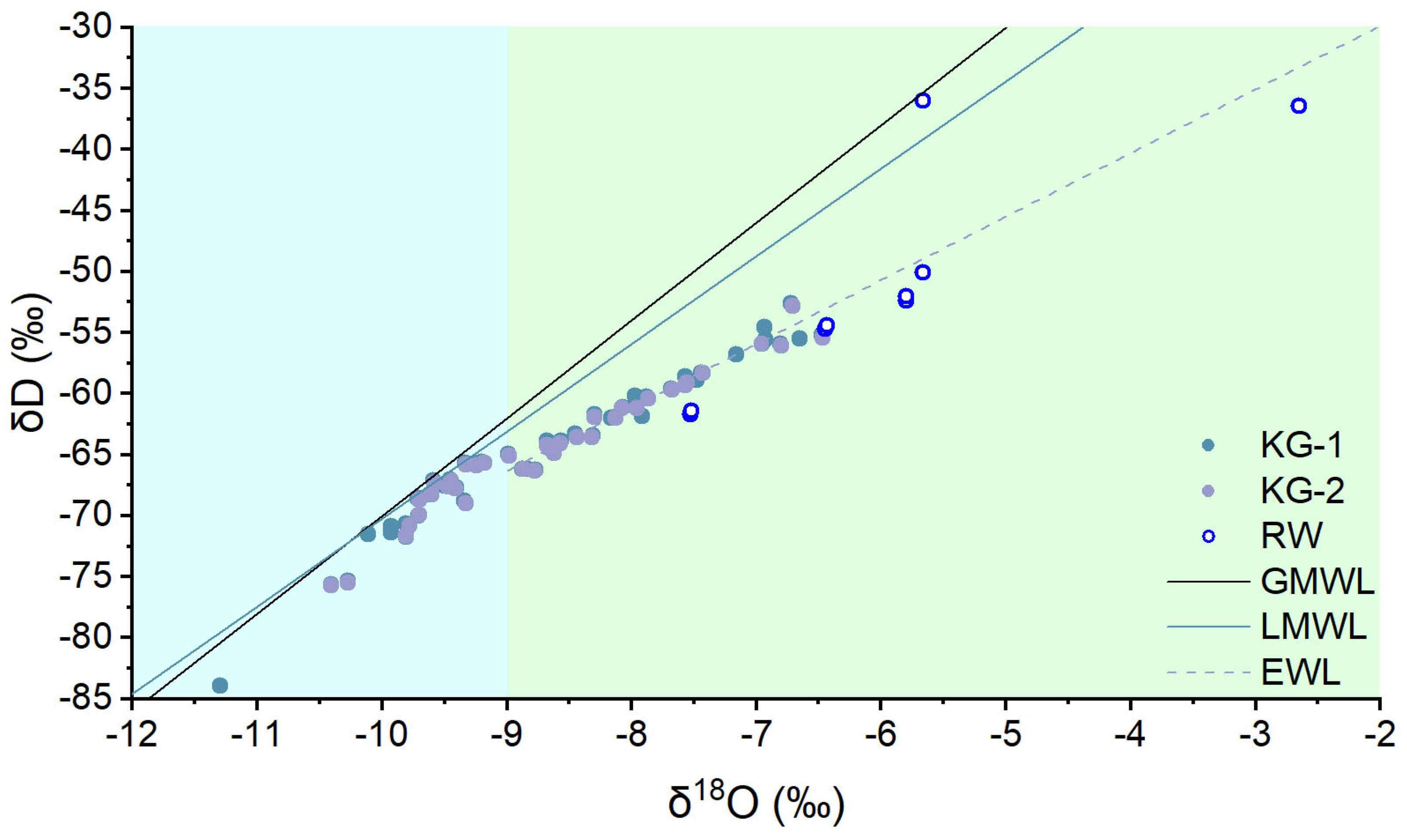
Atmospheric precipitation is typically one of the most important recharge sources for groundwater. However, since δD and δ
18O values in precipitation are subject to significant fractionation influenced by geographical and climatic factors, accurate interpretation of groundwater isotopic signatures requires the establishment of a reliable local meteoric water line (LMWL) based on year-round precipitation sampling. Unlike regions with long-term monitoring sites under the IAEA/WMO Global Network for Isotopes in Precipitation (GNIP), the Beijing area lacks such international and long-term stations. To address this limitation, previous studies have established regional LMWLs based on locally collected precipitation data in Beijing. In particular, Hao et al. [
44] conducted systematic sampling from July 2011 to July 2012 at the Western Mountain region of Beijing, which is geographically closer to the study area than earlier work by Zhai et al. [
45] in the eastern plain of Beijing. Their results showed that δD ranged from −119.46‰ to −13.96‰ with an average of −61.86‰, while δ
18O ranged from −15.47‰ to −1.84‰ with an average of −8.87‰. Based on this dataset, the LMWL for the Western Mountain region was defined as δD = 7.17 δ
18O + 1.46 (
n = 39, R
2 = 0.9342) [
44]. Compared to the Global Meteoric Water Line (GMWL: δD = 8 δ
18O + 10, [
46]), the lower slope and intercept of the local line indicate that regional precipitation is influenced not only by oceanic moisture but also by arid climatic conditions and localized vapor recycling processes (
Figure 3).
The δD values of karst groundwater in the study area range from −84.00‰ to −50.30‰, with an average of −64.15‰, while δ
18O values vary from −11.29‰ to −5.75‰, averaging −8.58‰. These values fall entirely within the isotopic envelope of local precipitation, confirming that atmospheric rainfall is a major recharge source for the karst aquifer. As shown in
Figure 3, a subset of the groundwater samples plots closely along the LMWL, whereas others deviate toward the lower right, away from the LMWL. A linear regression of the karst groundwater isotopic data yields the equation δD = 5.21 δ
18O − 19.43, which features a significantly lower slope and intercept than the LMWL. This regression line can be interpreted as an evaporation water line (EWL,
Figure 3), indicating that, following meteoric recharge, the groundwater may have been influenced by additional sources or subject to evaporation.
Figure 3.
Comparison of δ
2H and δ
18O values of karst groundwater and Yongding River water in the study area with meteoric water lines. The Local Meteoric Water Line (LMWL) is based on the work of Hao et al. [
44], while the Global Meteoric Water Line (GMWL) follows Craig [
46]. EWL stands for Evaporation Water Line. KG-1 represents karst groundwater data from Qin et al. [
23], while KG-2 and Yongding River water data are sourced from Li [
47]. Blue-shaded areas (δ
18O < −9.00‰) indicate groundwater primarily recharged by precipitation; green-shaded areas (δ
18O > −9.00‰) indicate groundwater recharged by a mixture of precipitation and Yongding River water.
The Yongding River water exhibits δD values ranging from −61.91‰ to −36.00‰, with an average of −50.30‰, and δ
18O values from −7.52‰ to −2.65‰, with a mean of −5.86‰ [
23,
47]. These isotopic compositions are more enriched relative to the karst groundwater and also lie to the right of the LMWL, consistent with evaporative modification. Notably, most of the river water samples align with the same regression line defined by the groundwater samples, indicating a strong isotopic correlation between the two and implying hydrological connectivity.
Further analysis shows that groundwater samples with δ
18O values less than −9.00‰ tend to cluster tightly along the LMWL, consistent with recharge primarily from direct precipitation. In contrast, karst groundwater samples with δ
18O values greater than −9.00‰ generally align with the linear regression line of karst groundwater (previously defined in this section, representing an evaporation-influenced trend), and many of them overlap with river water samples. According to the δ
18O contour map of the study area derived from Li’s dataset [
47], these isotopically enriched groundwater samples are predominantly distributed along the banks of the Yongding River. This spatial distribution further supports the interpretation that river leakage significantly contributes to the recharge of the local karst groundwater system.
A similar pattern was observed by Tang et al. [
48] in their study of the Niangziguan karst spring, a representative large karst spring system in northern China located in Shanxi Province. Using δD and δ
18O analyses, they identified a dual recharge mechanism involving both direct infiltration of meteoric precipitation and river leakage. Specifically, isotopically depleted karst groundwater, characterized by more negative isotopic values, was associated with direct recharge from local precipitation and showed weak or negligible hydraulic connectivity with surface water. In contrast, groundwater that received substantial input from river leakage showed isotopic enrichment and overlapped significantly with the isotopic signatures of river water.
In the context of the present study, a similar differentiation is evident. Karst groundwater that is primarily recharged by atmospheric precipitation tends to display more negative isotopic values and is mainly distributed in the Tanzhesi area (
Figure 1). Conversely, groundwater with mixed recharge from both precipitation and river seepage exhibits more enriched isotopic signatures, aligning closely with those of the Yongding River. These enriched groundwater samples are predominantly found in the Junzhuang area (
Figure 1) and along the course of the river itself. This spatial and isotopic pattern underscores the importance of both recharge sources and highlights the significant role of river leakage in shaping the hydrogeochemical characteristics of the YM karst system.
3.3. Tracing Groundwater Sources Using Strontium Isotopes
Strontium isotopes have emerged as a robust tool for investigating groundwater provenance, water–rock interactions, and mixing processes in complex hydrogeological systems [
49]. In natural settings, strontium (Sr) is primarily hosted in minerals such as strontianite (SrCO
3), celestite (SrSO
4), plagioclase feldspars, and apatite. Among the four naturally occurring isotopes of strontium—
84Sr,
86Sr,
87Sr, and
88Sr—the
87Sr/
86Sr ratio is widely employed as a geochemical tracer because
8787Sr is radiogenic (produced by the decay of
87Rb), while
86Sr is stable and non-radiogenic. This isotopic ratio is sensitive to the lithology through which water has interacted, thus providing valuable insights into groundwater flow paths and source contributions [
50,
51].
Typical
87Sr/
86Sr values vary with rock type and can serve as diagnostic end-members in mixing models. Marine carbonates such as Ordovician limestone generally exhibit low
87Sr/
86Sr values, consistent with the composition of ancient seawater during that period, ranging from 0.707840 to 0.709100 [
52,
53]. Dolomites tend to display slightly higher ratios (~0.711), while silicate-rich rocks—especially granitic or metamorphic terrains—can exceed 0.715 due to prolonged radiogenic accumulation from Rb-rich minerals [
54].
Atmospheric precipitation in the Beijing region shows
87Sr/
86Sr values ranging from 0.709118 to 0.710357 [
55], while water samples from the Yongding River have reported values around 0.710331 [
23]. These benchmarks provide essential reference points for interpreting strontium isotope signatures in local karst groundwater.
Plotting
87Sr/
86Sr ratios against the molar ratio of Mg
2+/(Mg
2+ + Ca
2+) for groundwater, precipitation, and river water samples in the study area reveals important patterns (
Figure 4). Most karst groundwater samples fall within a narrow range of
87Sr/
86Sr values between 0.708 and 0.710 and Mg
2+/(Mg
2+ + Ca
2+) values between 0.226 and 0.562, consistent with extensive interaction with carbonate lithologies, particularly limestone [
23]. This isotopic signature is indicative of waters that have undergone dissolution processes typical of flow through Ordovician limestone formations.
The spatial distribution of
87Sr/
86Sr ratios and Mg
2+/(Mg
2+ + Ca
2+) values across the study area provides further insights into groundwater recharge pathways and lithological controls (
Figure 4). Karst groundwater samples from the Tanzhesi area (KG-T) cluster closely with local rainwater, exhibiting
87Sr/
86Sr ratios below 0.710 and relatively low Mg
2+/(Mg
2+ + Ca
2+) values. This geochemical similarity indicates that these waters are primarily recharged by local precipitation, with minimal influence from other geological sources. In contrast, groundwater samples from the Junzhuang area (KG-J) also plot near the rainwater field but show a slight shift toward higher Mg
2+/(Mg
2+ + Ca
2+) ratios. This shift suggests enhanced water–rock interaction or partial mixing with Yongding River water, which is characterized by a distinct isotopic signature. Together, these observations support the interpretation that karst groundwater in the Junzhuang area receives mixed recharge from both atmospheric input and river seepage.
Notably, buried karst groundwater near the YM Spring shows significantly higher
87Sr/
86Sr ratios (>0.712,
Figure 4). These values suggest either interaction with silicate-rich rocks, greater residence times, or mixing with Quaternary porous aquifer waters that have undergone prolonged water–rock interaction. Their separation from the main limestone cluster indicates a different recharge history or deeper flow path.
Figure 4.
Relationship between
87Sr/
86Sr and Mg
2+/(Mg
2+ + Ca
2+) ratios for precipitation, karst groundwater, and Yongding River water in the study area. Rainwater data are from Xu and Han [
55], while all other data are sourced from Qin et al. [
23]. KG represents karst groundwater in the study area; KG-T and KG-J refer to samples from the Tanzhesi and Junzhuang areas, respectively.
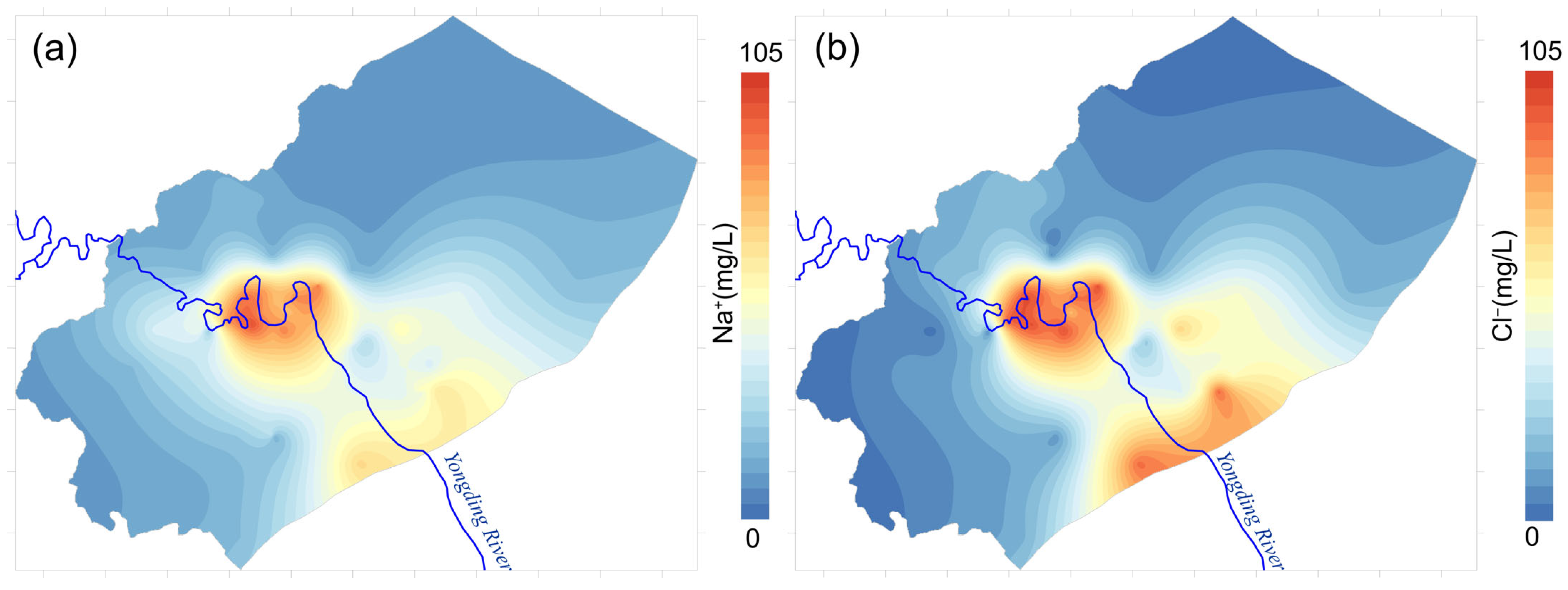
3.4. Tracing Recharge Using Na+ and Cl− Concentrations
Sodium (Na+) and chloride (Cl−) are widely regarded as conservative tracers in hydrogeological studies due to their low reactivity and minimal participation in most geochemical processes. These ions are commonly used to identify mixing processes between different water bodies and to trace the sources of salinity. In coastal aquifers, elevated concentrations of Na+ and Cl− often indicate seawater intrusion. In inland systems, however, their variations can reflect water–rock interactions, evaporation effects, or contributions from anthropogenic or surface water sources.
In the YM karst system, notable differences in Na
+ and Cl
− concentrations exist between river water and karst groundwater, making them useful indicators of recharge pathways and mixing processes. Previous studies [
23] have shown that Yongding River water, which flows through the study area, is characterized by relatively high concentrations of Na
+ and Cl
−, likely due to upstream anthropogenic inputs and longer surface residence time. In contrast, karst groundwater flowing through carbonate formations typically contains lower concentrations of these ions, as carbonates contribute minimally to Na
+ and Cl
− loads during dissolution.
Precipitation in the Beijing region exhibits significantly lower concentrations of both Na+ and Cl−, with values ranging from 0.09 to 4.14 mg/L for Na+ and 3.02 to 7.68 mg/L for Cl−. This reinforces the interpretation that rainwater may serve as a dilute end-member for both karst groundwater and river water.
A comparative analysis of Na
+ and Cl
− concentrations in the study area reveals that karst groundwater samples collected along the Yongding River corridor exhibit significantly elevated Na
+ (5.3~95.7 mg/L) and Cl
− (8.2~104 mg/L) concentrations relative to other karst groundwater sites [
23]. This spatial trend aligns well with the hypothesis that river water contributes to the recharge of the karst aquifer, especially in the vicinity of the riverbed. The enrichment in Na
+ and Cl
− can thus be attributed to seepage from the Yongding River into the underlying carbonate aquifer system, reinforcing conclusions drawn from isotopic evidence in previous sections (
Figure 5).
Figure 5.
Spatial Distribution of Na
+ (
a) and Cl
− (
b) in karst groundwater and their relationship with the Yongding River in the study area. Contour map derived from Qin et al. and Tang et al. [
23,
40].
Figure 5.
Spatial Distribution of Na
+ (
a) and Cl
− (
b) in karst groundwater and their relationship with the Yongding River in the study area. Contour map derived from Qin et al. and Tang et al. [
23,
40].
Overall, the spatial correspondence between elevated Na+ and Cl− levels in groundwater and proximity to the river channel supports the existence of a hydraulic connection between the Yongding River and the karst groundwater system, particularly in areas where geological conditions enhance vertical permeability.
4. Flow Patterns of Karst Groundwater
While multi-isotope and hydrochemical analyses provide valuable insights into the recharge sources and mechanisms of karst groundwater, a full understanding of the subsurface flow regime requires further investigation of flow pathways and residence times. In this section, we build on the recharge findings by integrating results from previous geophysical surveys and groundwater age data. Together, these datasets allow us to delineate preferential flow channels, infer flow patterns at depth, and ultimately construct a conceptual model of karst groundwater flow in the study area.
4.1. Preferential Flow Pathways Identified by Geophysical Methods
Due to the highly heterogeneous nature of karst media, it is often difficult and economically prohibitive to characterize subsurface permeability structures solely through drilling. In this context, geophysical methods offer a cost-effective and non-invasive alternative for identifying preferential groundwater flow pathways.
To investigate the structural controls on groundwater flow within the YM Spring catchment area, Tang et al. [
40] conducted a 16 km-long geophysical survey along the Yongding River from Junzhuang downstream, combining magnetotelluric (MT) and controlled-source audio-frequency magnetotelluric (CSAMT) methods. Their results revealed five distinct low-resistivity zones, interpreted as concealed fractured fault zones based on their linear geometry and absence of surface outcrops; this includes the concealed segment of the Yongdinghe Fault. These hidden fault zones are interpreted to potentially function as preferential flow pathways for karst groundwater, serving as subsurface conduits in certain segments. However, their hydraulic role may vary spatially, with some faults potentially acting as barriers or confining structures under different geological conditions. Additionally, the MT and CSAMT profiles confirmed that the core of the Jiulongshan–Xiangyu syncline (S1 in
Figure 1), composed of Cambrian and Ordovician carbonate rocks, is buried to depths exceeding 2000 m. This finding challenges the deep circulation model proposed by Chen et al. [
56], who suggested that Yongding River leakage recharges groundwater at Junzhuang, forming a confined aquifer system that flows southeastward through the ultra-deep carbonate core of the syncline. However, such deep circulation would be expected to produce elevated TDS and temperature anomalies, neither of which is supported by the current hydrochemical and thermal observations. These results, instead, support a model in which precipitation and river seepage recharge the system at Junzhuang, followed by shallow subsurface flow through Yongding River alluvial deposits and fractured zones toward the southeast (
Figure 6).
To further refine the understanding of karst groundwater pathways, Li et al. [
57] carried out an integrated geophysical investigation focused on delineating the runoff pathways of karst groundwater feeding the YM Spring. Using gravity surveys, CSAMT profiles, and microtremor measurements, they characterized the bedrock topography and structural fabric between the western flank of the spring and the Yongding River. A total of 10 potential fault structures were interpreted, most of which are normal faults that likely serve dual roles as both aquifer boundaries and conduits. Their interpretation identified a dominant karst flow path characterized by high-permeability fractured zones, extending along the Yongding River fault zone from Junzhuang and turning northeastward near the Babaoshan fault (
Figure 6). This newly recognized preferential flow path provides a scientific basis for understanding and potentially restoring discharge at the YM Spring.
4.2. Karst Groundwater Residence Time Distribution
Groundwater age, also referred to as groundwater residence time, denotes the time elapsed since water entered the subsurface system through recharge until it exits via discharge [
58,
59]. This parameter is critical for understanding groundwater renewability and the dynamics of its interaction with surrounding geological media. Groundwater age exerts strong control on the evolution of hydrochemical and isotopic characteristics, including solute concentrations, temperature, and isotopic signatures, and serves as a key indicator of flow velocity, circulation depth, and hydrologic connectivity in aquifer systems.
In the YM Spring catchment area, groundwater residence times were estimated by Li [
47] using a combination of radioactive isotopes (
3H,
14C) and chlorofluorocarbon (CFC) tracers. The results show that the karst groundwater in this area is generally young, with 86.7% of samples having residence times of less than 30 years, and only 8.9% exceeding 50 years. This indicates a predominantly active and rapid circulation system with strong renewal capacity. Spatially, the typical recharge zones at Tanzhesi and Junzhuang are characterized by shallow groundwater ages ranging from 3 to 21 years, attributed to well-developed karst fissures and rapid infiltration of precipitation. In contrast, groundwater in the downstream discharge area of the YM Spring exhibits older ages between 17 and 29 years, reflecting cumulative travel times along the flow paths.
The analysis of groundwater age data along the main flow paths toward the YM Spring provides further insights into the regional flow dynamics. Groundwater recharged in the Junzhuang area flows southeastward along the Yongding River fault zone (F4,
Figure 1b), where residence times remain relatively stable between 18 and 21 years. This consistency suggests a high-permeability flow path, where the fault zone facilitates rapid lateral transport of river-derived recharge. However, upon approaching the intersection with the Huangzhuang–Gaoliying Fault (F3,
Figure 1b), residence times gradually increase from 18 to 27 years as groundwater continues toward the spring outlet. This pattern suggests a transition to slower flow velocities or enhanced mixing with older water, potentially due to structural barriers or compartmentalization introduced by fault interactions. The observed spatial trends in groundwater age thus emphasize how faults of varying nature contribute to shaping both the flow patterns and residence times of karst groundwater.
4.3. Integrated Conceptual Model of Karst Groundwater Recharge and Flow Pathways
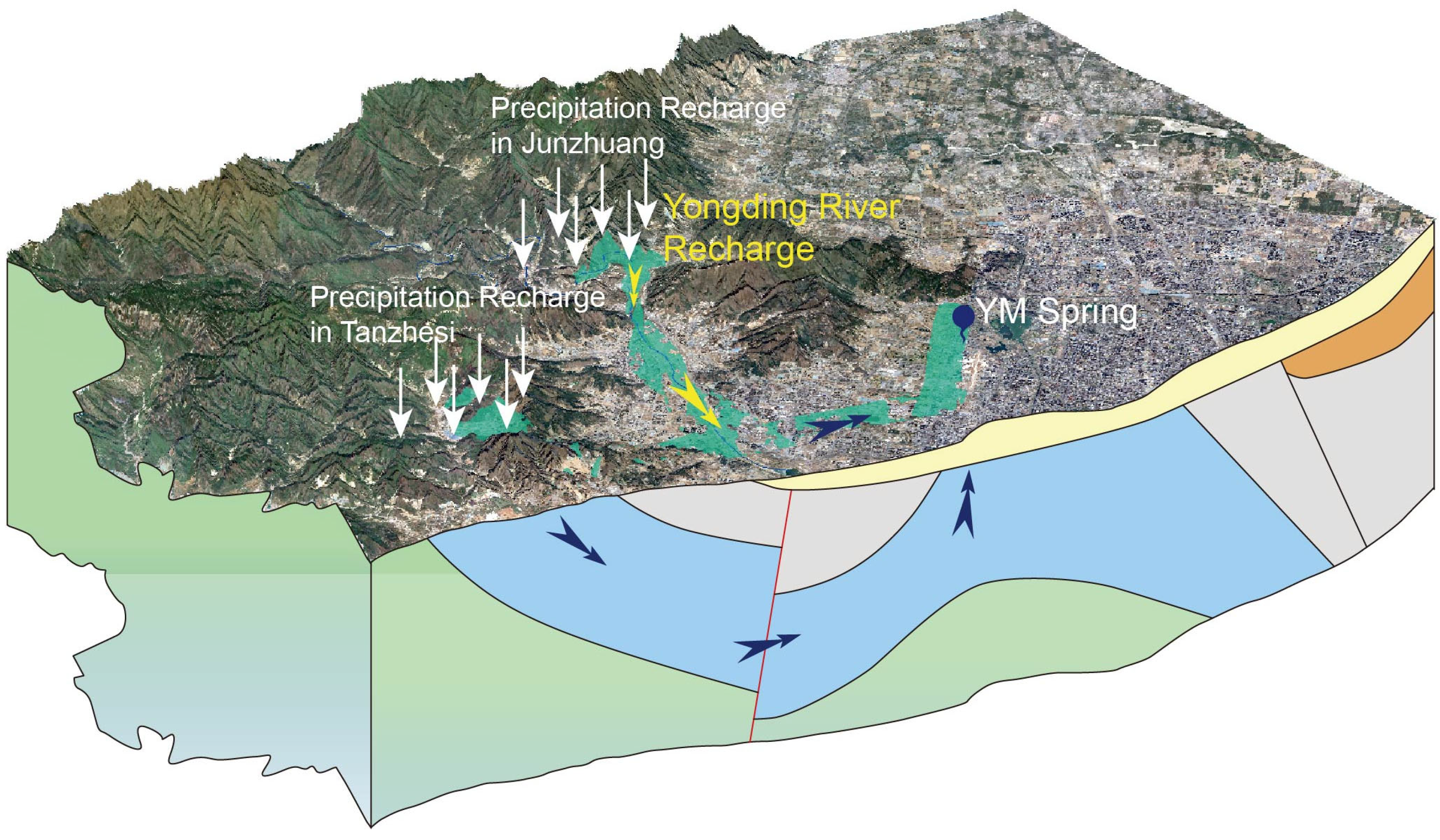
A synthesis of the hydrogeochemical, isotopic, and geophysical evidence reveals a comprehensive understanding of the karst groundwater flow system in the study area. The YM Spring catchment area receives recharge from multiple sources, including direct infiltration of local precipitation, seepage from surface water (notably the Yongding River from Yanchi to Junzhuang), and lateral inflow from adjacent recharge zones. Groundwater movement is strongly influenced by the orientation of geological structures, the spatial distribution of carbonate aquifers, and the overall morphology of the stratigraphy. Groundwater discharge in the system primarily occurs through artificial extraction, lateral outflow, and natural spring discharge.
Two main recharge zones have been identified: the exposed Ordovician limestones in the Tanzhesi and Junzhuang areas. In the Tanzhesi area, precipitation infiltrates directly into fractured carbonate rocks, forming groundwater that flows along the strike of the Ordovician strata from the southwest to the northeast, ultimately discharging at the YM Spring or contributing to downstream lateral outflow (
Figure 7).
In contrast, the Junzhuang area receives not only precipitation recharge but also significant seepage input from the Yongding River. The resulting karst groundwater flows along three primary pathways (
Figure 7):
Shallow Riverbed Flow path: Part of the river-infiltrated groundwater flows along the Yongding River fault and alluvial sediments at shallow depths, crossing the Jiulongshan–Xiangyu syncline from northwest to southeast. It eventually re-enters the carbonate aquifer near the Bajiao area (
Figure 1b) through fractured zones, where it merges with groundwater from Tanzhesi. The combined flow then turns northeast and discharges at the YM Spring.
Deep Syncline Flow path: Another portion of groundwater recharged at Junzhuang follows the northwest limb of the Jiulongshan–Xiangyu syncline, moving downgradient through Ordovician carbonates into the deeper core of the syncline. It then resurfaces along the southeast limb and discharges at the YM Spring. Due to the lack of supporting hydrochemical, isotopic, and temperature data, this deep flowpath remains a subject of debate.
Direct Lateral Flow: Some groundwater continues laterally to the downstream regions via inter-aquifer flow or transitions into the overlying Quaternary porous aquifer system via upward leakage or baseflow interaction.
In addition, the presence and distribution of cave points, as shown in
Figure 1b, provide further evidence for identifying major karst flow pathways. These caves are typically formed along zones of enhanced dissolution and represent locations where groundwater has actively contributed to the development of subsurface conduits. The alignment of cave points with inferred fault zones and zones of low resistivity supports the interpretation that these features function as preferential flow channels within the karst system. Therefore, the spatial distribution of caves is not only indicative of the intensity of karstification but also provides important clues for delineating recharge routes and dominant subsurface flow paths.
Discharge from the karst system occurs through the YM Spring, lateral flow toward the southeast, evapotranspiration, and hydraulic contributions to adjacent Quaternary porous aquifers. The integration of recharge mechanisms, structural controls, and hydrogeological data supports the construction of a conceptual model that highlights the complexity and multi-scale nature of karst groundwater circulation within the YM Spring domain.
4.4. Limitations and Future Research Directions
While this study presents a comprehensive characterization of recharge mechanisms and flow dynamics in the YM karst groundwater system using hydrogeochemical, isotopic, and geophysical evidence, several methodological and conceptual limitations remain. Addressing these limitations is essential for advancing our understanding of structurally complex karst aquifers, particularly in rapidly urbanizing and tectonically active regions like western Beijing. Future research should consider the following key priorities.
4.4.1. Expand the Spatial and Temporal Coverage of Groundwater Monitoring and Sampling
Despite the integration of multiple hydrogeological datasets, the current spatial and temporal distribution of groundwater samples remains limited, particularly in deeper carbonate formations and synclinal cores. This restricts our ability to validate conceptual models of deep flow paths. The scarcity of deep boreholes and the absence of long-term observational wells hinder assessments of subsurface connectivity and flow persistence. Furthermore, geothermal or hot spring water samples, which could provide valuable constraints on circulation depth and groundwater residence time, were not included in the current study. Establishing a multi-depth, long-term monitoring network that includes deep carbonate units is critical for improving sample representativeness and temporal resolution.
4.4.2. Apply a Broader Range of Isotopic Tracers to Reduce Source Uncertainty and Track Geochemical Evolution
The current analysis primarily utilizes δD, δ
18O, and
87Sr/
86Sr isotopes to infer recharge sources and mixing processes. While these tracers offer robust insights, their application in this study is largely restricted to a single hydrological period. The lack of multi-year or event-scale isotopic data limits our ability to evaluate seasonal dynamics or extreme recharge events. Future research should incorporate long-term isotope monitoring across multiple hydrological years, particularly during high-precipitation or drought periods. In addition, integrating additional geochemical and isotopic tracers could significantly enhance source attribution and improve understanding of geochemical evolution in both shallow and deep flow systems. For instance, the application of additional tracers, such as boron (δ
11B), calcium (δ
44/
40Ca), magnesium (δ
26Mg), and lithium (δ
7Li), and noble gases could improve our understanding of water–rock interactions, ion exchange, and groundwater residence time, especially in deeper zones [
60,
61,
62].
4.4.3. Enhance Subsurface Structural Characterization Through Integration of Geophysical and Fiber-Optic Temperature Sensing Techniques
Although MT and CSAMT surveys successfully identified low-resistivity anomalies interpreted as preferential flow zones, these methods have limited resolution in capturing fine-scale conduit geometries or hydraulic connectivity. Future studies should incorporate high-resolution electrical resistivity tomography (ERT), borehole logging, hydraulic tomography (HT), and possibly cross-hole tomography to better resolve the structure and properties of conduit networks [
29,
63]. Furthermore, distributed temperature sensing (DTS) using fiber-optic cables represents a promising complementary approach [
64]. DTS can detect subtle temperature anomalies caused by groundwater flow and, when combined with ERT, can help distinguish between conductive and resistive pathways. This integrated strategy could significantly improve our ability to assess the hydrologic function of faults (e.g., conduits vs. barriers) and map the spatial configuration of karst features and their connectivity with recharge sources [
65,
66].
4.4.4. Integrate Multi-Source Datasets Through Advanced Fusion Techniques for Improved Flow Modeling
Given the inherent heterogeneity and data sparsity of karst systems, future research should prioritize the development of data-driven fusion frameworks capable of integrating multi-scale hydrogeological datasets. Probabilistic models, Bayesian networks, and machine learning algorithms can accommodate uncertainties while synthesizing disparate data sources, including structural, geophysical, isotopic, and hydrochemical information [
67,
68,
69]. These approaches have the potential to enhance our ability to delineate recharge zones, simulate flow pathways, and predict discharge behaviors under varying climatic and anthropogenic scenarios [
70]. Coupling such data-driven tools with process-based numerical models and refined conceptual frameworks will be essential for quantifying the dynamics of karst aquifers and improving resource management in similar fractured terrains.
5. Conclusions
Karst groundwater systems are of critical importance for maintaining ecological balance, ensuring drinking water security, and sustaining river baseflow, especially in water-scarce regions of northern China. The YM Spring, historically among the largest karst springs in western Beijing, has long served as an important indicator of regional groundwater dynamics in the capital city of China. However, the spring has ceased discharging for years, reflecting both environmental degradation and the intensifying pressure on Beijing’s urban water supply. In this context, improving the understanding of the hydrological processes governing karst groundwater recharge, flow, and discharge in the YM Spring catchment area is not only of academic interest but also essential for water resource management and spring restoration efforts.
This study integrates hydrochemical, isotopic, and geophysical data to refine the conceptual understanding of recharge mechanisms and flow pathways in the YM karst system. The results suggest that the main recharge zones are located in the Tanzhesi and Junzhuang areas, with groundwater predominantly following stratigraphic dip and structural controls toward discharge points such as YM Springs. Two principal flow pathways are proposed: one shallow and fault-guided, and the other potentially deep and structurally controlled beneath the Jiulongshan–Xiangyu syncline. However, the existence of the deep pathway remains speculative due to limited corroborative data.
Future work should address the following priorities: (1) Expand vertically resolved monitoring across multiple depths to obtain head, chemistry, temperature, and age data, especially in deep carbonate units and fault zones; (2) apply multi-isotope and non-traditional tracer techniques to better constrain recharge sources, geochemical evolution, and groundwater residence time; (3) integrate high-resolution geophysical methods, such as ERT and DTS, to delineate conduit networks and assess fault-zone permeability, particularly in structurally complex areas like Junzhuang; and (4) develop coupled, data-driven and process-based models that assimilate structural, geophysical, hydrochemical, and isotopic data to simulate recharge–discharge dynamics under varying climatic and anthropogenic pressures.
These strategies not only enhance the scientific understanding of karst aquifer behavior in tectonically complex settings but also inform practical measures for spring protection and potential restoration. Specifically, delineating key recharge areas and verifying dominant flow pathways will facilitate ecological zoning, targeted conservation efforts, and artificial recharge interventions, all critical to the long-term sustainability of karst groundwater resources in the Beijing region. Moreover, the conceptual framework developed in this study offers a transferable foundation for groundwater management in other karst systems.


