Article

Long-Term Water Level Projections for Lake Balkhash Using Scenario-Based Water Balance Modeling Under Climate and Socioeconomic Uncertainties

by
Sayat Alimkulov
,
Lyazzat Makhmudova
*,
Elmira Talipova
*,
Gaukhar Baspakova
,
Akhan Myrzakhmetov
,
Zhanibek Smagulov
and
Alfiya Zagidullina
Institute of Geography and Water Security, Pushkin Str. 99, Almaty 050010, Kazakhstan
*
Authors to whom correspondence should be addressed.
Water 2025, 17(13), 2021; https://doi.org/10.3390/w17132021
Submission received: 20 May 2025 / Revised: 25 June 2025 / Accepted: 1 July 2025 / Published: 4 July 2025
(This article belongs to the Special Issue Advance in Hydrology and Hydraulics of the River System Research 2025)

Abstract

The study presents a scenario analysis of the long-term dynamics of the water level of Lake Balkhash, one of the largest closed lakes in Central Asia, taking into account climate change according to CMIP6 scenarios (SSP2-4.5 and SSP5-8.5) and socio-economic factors of water use. Based on historical data (1947–2021) and a water balance model, the contribution of surface runoff, precipitation and evaporation to the formation of the lake’s hydrological regime was assessed. It was established that the main source of water resources for the lake is the flow of the Ile River, which feeds the western part of the reservoir. The eastern part is characterized by extremely limited water inflow, while evaporation remains the main element of water consumption, having increased significantly in recent decades due to rising air temperatures. Increasing intra-seasonal and interannual fluctuations in water levels have been recorded: The amplitude of short-term fluctuations reached 0.7–0.8 m, which exceeds previously characteristic values. The results of water balance modeling up to 2050 show a trend towards a 30% reduction in surface inflow and an increase in evaporation by 25% compared to the 1981–2010 climate norm, which highlights the high sensitivity of the lake’s hydrological regime to climatic and anthropogenic influences. The results obtained justify the need for the comprehensive and adaptive management of water resources in the Balkhash Lake basin, taking into account the transboundary nature of water use and changing climatic conditions.

1. Introduction

Closed lakes are socially and ecologically important components of many regional landscapes. Studying how lakes respond to projected future climate and economic scenarios can provide important information needed to inform stakeholders about potential changes in these water bodies in the coming years [1]. Qualitative or quantitative descriptions of the future through scenario development have become one of the key methods when it comes to long-term perspectives, for example, up to 2050, especially when attempting to combine socioeconomic and climate uncertainties [2]. It is expected that the trend of global warming will lead to significant changes in key hydrometeorological cycles, including changes in the quantitative and spatial distribution of atmospheric precipitation, evaporation from water surfaces, transpiration in watersheds, and the intensity of water consumption for domestic purposes [3].
Global climate change has led to large fluctuations in lake levels in recent years, as lake levels are influenced by many factors, both natural (river runoff, air temperature, evaporation, precipitation, etc.), and anthropogenic [4,5,6,7]. The latter manifest themselves in the form of impacts on watersheds and directly on the hydrographic network (flow regulation through the creation of reservoirs, water abstraction, etc.).
Currently, many closed lakes are disappearing due to recent climate change, and some of them have drastically changed their size and shape over time, shrinking during the dry season or splitting into several smaller parts. In addition, increased economic activity and human use of freshwater resources, including irrigation, especially in arid regions, places additional stress on watersheds, causing lakes to shrink and dry up [8,9,10]. As a result, many closed lakes in developed and developing countries have shrunk dramatically, leading to increased salinity, high concentrations of pollutants, and ecosystem destruction. A striking example of the combined effects of anthropogenic and climatic factors is the drying up of the Aral Sea. Starting in the 1960s, the Aral Sea was the second largest lake in the Republic of Kazakhstan until it became shallow, and it has been the focus of widespread attention since then due to rapid drying and salinization caused by intensive human economic activity in the basin [11]. Many large lakes around the world are shrinking or disappearing, such as Lake Urmia in Iran [12], Lake Chad in Central Africa [13], and Lob Nor in northwestern China [14]. The tragedy of Lake Urmia is one of Iran’s most catastrophic water problems. Currently, the lake is in an extremely dire state and will become a tragedy and disaster of monumental proportions if effective restoration measures are not taken [12]. The area of Lake Chad has shrunk by more than 90% since 1963 due to unfavorable climatic trends in the lake basin and the uncontrolled use and irrational management of transboundary water resources by four countries (Cameroon, Nigeria, Niger, and Chad), both of the lake itself and its surface inflows. Thus, closed basins face major challenges in terms of water management [15], in particular, the coordination of water use within the framework of economic development and ecosystem restoration, as well as the resolution of the intractable problem of the “tragedy of the commons” [16]. Consequently, lake restoration and effective management are essential for the sustainable development of arid regions [17].
In turn, most of Central Asia is a giant closed basin, and studying changes in lake area and level, as well as analyzing the factors causing these changes, is important not only for the development of the socioeconomic situation but also for the ecology of the region [18]. Central Asia occupies one-third of the world’s arid land, where rivers and lakes are the main sources of surface water resources [19]. There are more than 6000 lakes with a total area of 12,300 km2, most of which are closed [20]. Closed lakes include the Aral Sea, Balkhash, Alakol, Ebinoor, and Lobnor lakes. These lakes have a number of distinctive features that are not typical of lakes in humid regions of the Earth [21]. Warming rates exceed global averages [22,23], which increases evaporation from lake surfaces [24] and accelerates glacier degradation [25,26]. Rapid melting and the retreat of glaciers pose a threat of short-term floods and, in the long term, lead to a decrease in water resources and water security in the region [27,28].
The closed-basin Lake Balkhash, located in an arid, dry zone and 80% dependent on surface runoff, is most vulnerable to changes in runoff and climate. The hydrological regime and water balance of Lake Balkhash have been repeatedly described and assessed by various research and design organizations. The first studies on the quantitative characteristics of the water balance of Lake Balkhash were conducted by A.V. Shnitnikov [29]. Later, many researchers were involved in calculating the water balance of this reservoir: G.R. Yunussov, L.K. Blinov and M.A. Burkaltsova, M.N. Tarassov, A.N. Zhirkevich, T. Iskendirov, R.D. Kurdin, N.A. Bagrov, I.S. Sosedov, V.V. Golubtsov, A.N. Zhirkevich, I.I. Skotselias, L.P. Ostroumova, Zh.D. Dostay, D.K. Dzhuzupbekov, and S.K. Alimkulov, et al. [30,31,32,33,34,35,36,37,38,39]. Despite the fact that water balance calculations have been made repeatedly in the past, there are still many unresolved issues.
From the point of view of water balance and external water exchange, scientific research on Lake Balkhash is particularly important due to its complex hydrological structure and the transboundary nature of its main water source (the Ile River). External water exchange, due to the transboundary nature of the Ile River, creates additional challenges for managing the lake’s water resources. Since most of the water resources come from China, any change in water use policy in the neighboring country directly affects water level fluctuations in the lake. The expected reduction in river flow in the region caused by climate change and increased water consumption requires serious efforts to preserve Lake Balkhash in its current state. Lake Balkhash, located in an arid climate zone, experiences significant evaporation, which creates a water deficit and exacerbates the problem of maintaining water balance. Research aimed at studying the quantitative characteristics of the lake’s water balance in detail plays a key role in understanding current and future changes in the water level of Lake Balkhash.
The long-term forecasting of water levels in large lakes remains an important but still unresolved fundamental and practical problem. The difficulty of the long-term forecasting of the Balkhash Lake level is due to the fact that all types of fluctuations (monthly, seasonal, interannual, multi-year, century-long, and millennial) depend on a large number of factors, and when studying future changes in the Balkhash Lake level, various factors must be taken into account: meteorological, hydrological, and anthropogenic. To achieve the goals and objectives in the field of assessment and forecasting, it is planned to use general methods applied in applied research. To assess possible changes in the level of Lake Balkhash, a scenario approach was used, which provides for the assessment of the main elements of the water balance in accordance with the adopted CMIP6 climate scenarios. Based on existing climate models and estimates of anthropogenic pressures, three-time intervals can be identified for forecasting the level of Lake Balkhash in the future, taking into account climate variability and economic activity: 2030 (2025–2034), 2040 (2035–2044) and 2050 (2045–2054).
Water balance assessment methods can range from very simple equations to complex computer models that allow the water balance to be calculated at different temporal and spatial scales. The choice of an appropriate methodology depends on the research objectives and the availability of data. This scientific study examines the possibility of conducting a comprehensive analysis of the water balance of Lake Balkhash. These studies not only expand scientific knowledge about the Balkhash-Alakol Basin but also contribute to the development of practical recommendations for sustainable water management in the region in the face of new challenges. Scientific research aimed at studying and preserving Lake Balkhash is extremely relevant, as it contributes to solving one of Kazakhstan’s key environmental problems in ensuring the sustainable development of the region.

2. Materials and Methods

2.1. Study Area

The catchment area of Lake Balkhash alone is about 413,000 km2, and 15% of its territory lies in the northwestern part of the Xinjiang Uygur Autonomous Region of the PRC. Surface water flows into Lake Balkhash mainly through the Ile, Karatal, Aksu, and Lepsy rivers (sometimes the Ayagoz River) (Table 1). The Ile River flows into Western Balkhash, while the other tributaries flow into Eastern Balkhash. The Bakanas, Tokyrauyn, Moiynty, and Zhamanty rivers, which flow from the northern part of the catchment basin—from the slopes of the Saryarka—have negligible flow, are temporary watercourses, and do not reach Lake Balkhash every year. The same is true of the temporary watercourses that originate in the Shu-Ile watershed. Their surface runoff is lost on the alluvial cones [37,38,39].
The main of these watercourses is the Ile River, which in natural conditions accounts for about 80% of the total surface inflow of river water. The total length of the river is 1439 km, of which 815 km is within Kazakhstan. The total area of the Ile River basin is 131,000 km2 (approximately 75% of the catchment area of Lake Balkhash), of which 77,400 km2 is located in the republic. The main water-forming part of the basin is located in the PRC, where the hydrographic network is well developed (from 0.6 to 3 km/km2). Its density decreases in the middle and lower parts of the basin (to 0.01 km/km2) with extensive areas completely devoid of surface runoff; only the left bank zone is active here.
In terms of hydrological conditions, the Balkhash Lake basin consists of a runoff formation zone (mountainous part) and a runoff dispersion or loss zone (flat part) (Figure 1). The runoff formation area of the basin includes the Tanyrtau and Zhetysu Alatau mountain ranges, separated by the Ile Depression. The hydrological features of the water resource formation area are discussed in detail in the works [39]. Based on the analysis of the water balance and genetic dissection of hydrographs, three natural zones have been identified, characteristic of the conditions of runoff formation.
The territory above 3000 m is covered by a high-mountain nival-glacial zone of glacial and snow feed. A distinctive and particularly important element of the landscape, in terms of hydrology and atmospheric moisture condensation, is glaciation, which covers the headwaters of almost all significant rivers. Runoff from the glaciated area depends on both the amount of atmospheric precipitation and the heat balance during the ablation period, so the formation of runoff from glaciers is clearly influenced by altitude and exposure.
The second zone is the middle mountain zone, located below an altitude of 1500 m. Rivers are mainly fed by meltwater from seasonal snow. A certain proportion comes from liquid precipitation that falls during and after snowmelt, as well as from torrential rainfall that causes floods during the high-water period.
In the lower zone, runoff is formed by snowmelt with a higher proportion of rainwater during the flood season, and by groundwater during the rest of the year. Friable fragmental deposits on the alluvial cones through which these rivers flow contribute to a significant part of the runoff in the lower zone being carried by the soil [37].

2.2. Data

In this study, the water balance of Lake Balkhash was calculated for the period 1947–2021. Official data on river flow and meteorological observations provided by the Kazhydromet State Agency and published on its official website (https://www.kazhydromet.kz/ru/gidrologiya, accessed on 10 December 2024) were used as source information.
To analyze the long-term dynamics of the water level, materials from systematic observations of hydrological stations (both lake and river) were used. In different years, water level monitoring was carried out at 19 observation points, of which 4 are still in operation today: the Mynaral station, the Karakum aul, the Saryshagan station, and the city of Balkhash (Figure 2).
In the assessment of water inflow to Lake Balkhash, observational data from 10 hydrological gauging stations located along the tributary rivers were utilized. Scenario-based inflow projections employed both historical and modeled meteorological datasets from stations situated in runoff generation zones (9 meteorological stations), selected based on the highest correlation coefficients between streamflow and meteorological parameters (Figure 2).
To estimate precipitation directly over the lake surface and evaporation losses, meteorological data from five stations near the lake (Aktogay, Algazy Island, Balkhash, Saryshagan, and Kuigan) were analyzed.
Scenario-based projections of the main water balance components of Lake Balkhash were carried out using ERA5-Land Monthly Aggregated reanalysis data from the ECMWF Climate Reanalysis framework, driven by CMIP6-based emission scenarios SSP2–4.5 and SSP5–8.5. To assess the current land use conditions within the Balkhash basin, a 2021 land cover dataset from the Living Atlas of the World (ArcGIS, https://livingatlas.arcgis.com/landcover/, accessed on 19 May 2025) was used. This dataset provides global high-resolution satellite-derived land cover data suitable for climate and hydrological modeling applications.

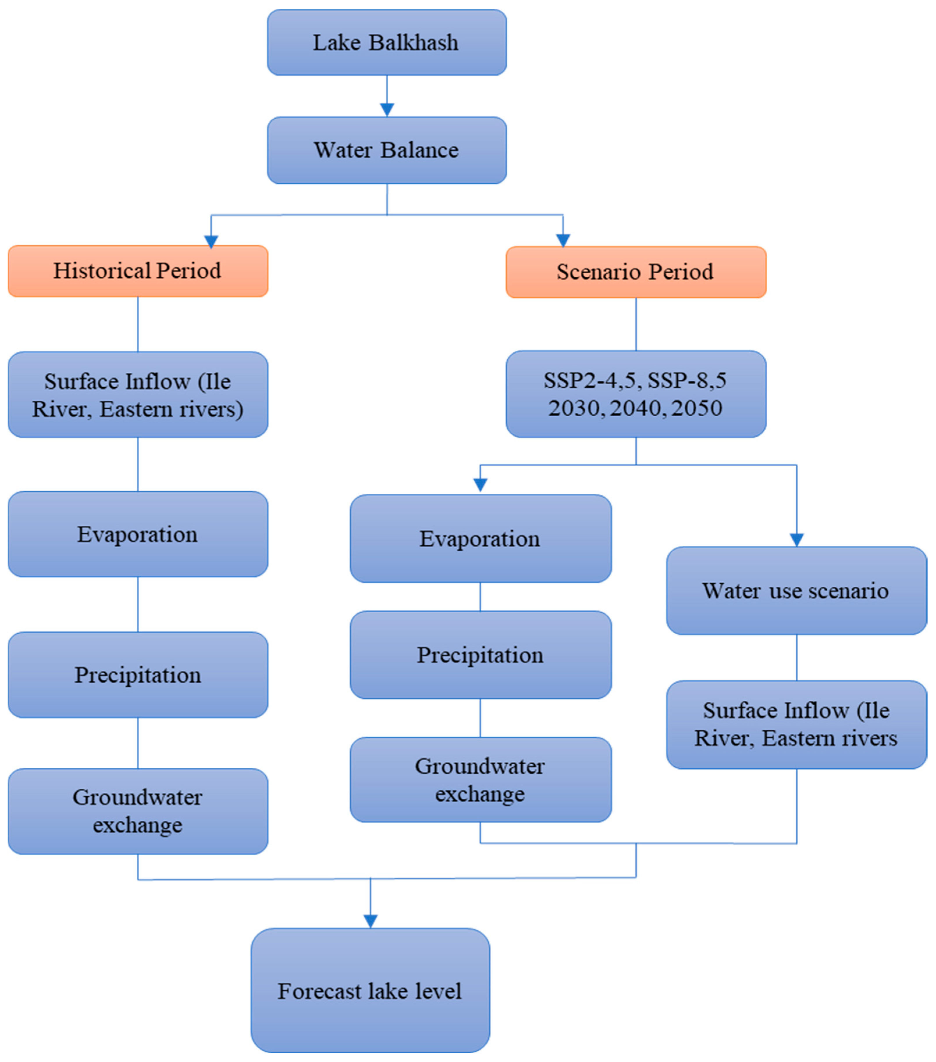
2.3. Research Methods

Water balance method. Monitoring the condition of Lake Balkhash and maintaining its current level is a complex task. One of the tasks of monitoring is to calculate the lake’s water balance, which assesses all the lake’s inflow and outflow characteristics—surface and underground water inflow into the lake, atmospheric precipitation falling on the lake’s surface, evaporation from the water surface, changes in the lake’s level and, ultimately, changes in its volume. The water balance equation for the closed Balkhash Lake is
Ws.i ± Wg + WX − WE = ±∆W
where, Ws.i is surface inflow (runoff from rivers), km3; Wg is the resulting underground inflow and outflow of the lake, km3; WX is atmospheric precipitation falling on the lake surface, km3; WE is evaporation from the lake surface, km3; and ∆W is the change in the volume of water in the lake, km3. A methodological block diagram for assessing the current and scenario-based lake level forecast is shown in Figure 3.
Surface inflow: Surface water inflow was determined separately for the western and eastern parts of the lake. Inflow into the western part of the lake occurs via the Ile River. Surface water inflow into Eastern Balkhash was calculated based on observations at stations on the Karatal River in the village of Razdolnoye, the Lepsy River at the Lepsy subsidiary farm, the Aksu River at the central base in Kyzyltan, and the Ayagoz River in the village of Karatas.
In this study, the reconstruction of conditionally natural flow was performed using an integrated methodology combining hydrological analogy, river channel water balance calculations, and estimation of irretrievable water consumption coefficients. This approach enabled a scientifically grounded reconstruction of the natural flow regime, while accounting for anthropogenic transformation of the river’s hydrology.
The core of the methodology was the hydrological analogy technique, where observed data from hydrological stations not affected by human activity were used to infer the natural characteristics of the flow regime. A comparative analysis of reconstructed (natural) and observed (regulated) streamflow allowed for an integral assessment of cumulative anthropogenic impact, without disaggregating specific factors such as water withdrawal, regulation, and irrigation. These methods have been described in detail and applied in a number of previous studies [40,41,42], where similar approaches were used to assess the impacts of water use and to reconstruct natural streamflow conditions under climate change and water management regulation.
The integrated runoff curve analysis revealed that divergence between observed and reconstructed flow in the Ile River began in the 1950s, coinciding with the onset of large-scale hydrological regulation and agricultural development.
To refine the structure of anthropogenic impacts, we additionally applied channel water balance modeling, which included components such as: precipitation over the river reach between gauging stations, evaporation from the river surface, lateral inflows from adjacent catchments, groundwater interaction, and reservoir and hydraulic infrastructure regulation.
These calculations helped quantify the transformation and withdrawal of flow across different reaches of the Ile River basin, particularly at key gauging points.
Further, the methodology included estimation of irretrievable water consumption using sector-specific return flow coefficients derived from official water use statistics. This included agricultural, industrial, and municipal sectors. These estimates provided additional quantitative validation of the reconstructed natural flow and confirmed the reliability of the methodological approach.
Scenario changes in river flow under climate change were assessed using a regression method based on establishing relationships between flow and meteorological parameters (air temperature and precipitation). The regression method allows us to construct an empirical mathematical model describing the response of the catchment to climate impacts, with subsequent application of this model to the predicted values of climate variables under two CMIP6 scenarios (data for the historical (1950–2014) and forecast (2015–2055) periods for two scenarios SSP2-4.5 and SSP5-8.5). The method is presented in the form of multiple linear regression. To effectively reduce data uncertainty in this study, an ensemble method was used for several models applicable to the territory of the Republic of Kazakhstan (23 models were selected from 34 models) (Table 2), comparing air temperature and precipitation values for the historical period with actual data from meteorological stations.
When forecasting river flow using scenario analysis, it is important to select the correct base period in order to establish regression relationships between flow and meteorological parameters. For Kazakhstan, the most reasonable periods are as follows:
1961–1990—used in a number of climate studies as a historical reference period, but this interval may become obsolete due to climate change;
1981–2010—the standard period of the World Meteorological Organization (WMO) for climate normalization;
1991–2020—a more relevant period proposed by the WMO, which reflects contemporary climate change but has less statistical stability compared to longer intervals [43]
This study analyzes the relationship between river discharge and meteorological parameters for different periods, and as a result, the period 1981–2010 was selected as the climate norm, since a high correlation between discharge and meteorological parameters was found during this period.
When making scenario-based forecasts of river flow, one of the key issues is the choice of meteorological data: whether to use actual measurements from weather stations or historical data from climate models (reanalysis). To establish a relationship between river flow and meteorological parameters, it is advisable to use actual data from weather stations rather than model historical data. This is due to the following factors:
Weather station data are instrumental measurements that reflect actual weather conditions. They are highly accurate, as they are collected under real conditions. In contrast, historical climate data obtained from CMIP6 models contain systematic errors and uncertainties associated with the parameterization of physical processes and limited spatial resolution of conditions [3].
Unlike model data, they record local climate features (e.g., the influence of orography, water bodies, vegetation) that are not always correctly reproduced by climate models [44]. For example, at the Narynkol weather station, located at an altitude of 1806 m above sea level, temperature data in CMIP6 models systematically differ from actual values by 2–4 °C (Figure 4), as global climate models use a coarse grid (100–250 km) that does not accurately account for local elevations.
Global climate models (GCMs) operate with high spatial resolution (100–250 km), which leads to smoothing of extreme events and possible systematic biases in temperature and precipitation [45].
If the input data contain errors, the regression coefficients will be incorrect [46]. Consequently, historical model data may contain systematic errors and require bias correction; otherwise, they will lead to incorrect approximations of dependencies [47]. Actual measurements allow for the correct consideration of extreme climate events (i.e., droughts, floods) that may be smoothed out in CMIP6 models [48].
Bias correction is a method for correcting systematic errors in climate models (i.e., GCM, RCM) in order to bring model data into line with observations. Normalization of forecast model data based on bias correction is carried out by correcting systematic errors in climate models, taking into account observational data. This process involves removing mean biases, equalizing variance, and bringing the distribution of forecast values into line with historical observations.
The main methods include linear correction, variance scaling, quantile matching, and regression models. Linear correction removes the mean systematic bias, while scaling takes into account differences in dispersion between model and actual data. Quantile matching corrects the distribution of values by matching empirical distribution functions. To perform the correction, it is necessary to compare the model and actual data, select a suitable method and apply it, and then verify the results using statistical indicators such as RMSE and NSE. More detailed information on bias correction can be found in the following sources [49,50].
Based on the above, it can be concluded that the use of actual weather station data in the base period is the optimal solution for scenario-based river flow forecasting. This minimizes errors, improves the accuracy of scenario-based river flow forecasts, and increases the reliability of forecasts in the long term.
Atmospheric precipitation: Atmospheric precipitation falling on the surface of a water body is usually calculated based on the readings of rain gauges at nearby meteorological stations located on the shores of Lake Balkhash—Aktogay, Saryshagan, Kuigan, Balkhash, and Algazy Island. The atmospheric precipitation layer was calculated monthly for the western and eastern parts of the lake separately; then, the volume of precipitation for the year was determined, taking into account the water surface area. When calculating atmospheric precipitation layers on the water surface, corrections for wetting, evaporation, and wind underestimation were introduced into the data from meteorological stations, which were determined in accordance with the methodology of the State Hydrological Institute and the recommendations of the Kazakh Scientific Research Hydrometeorological Institute [48,49,50].
Forecast values of atmospheric precipitation falling on the surface of the water body were also calculated using data from nearby meteorological stations, and the algorithm for calculating forecast values of the precipitation layer for Lake Balkhash includes the following steps:
  • Downloading of historical and forecast data on atmospheric precipitation from the reanalysis database (ERA5-Land Monthly Aggregated—ECMWF Climate Reanalysis) according to CMIP6 using climate models and scenarios (e.g., SSP2-4.5, SSP5-8.5) at 5 WSs coordinate points;
  • Normalization of forecast model data based on bias correction, taking into account actual WS data;
  • Correction of forecast precipitation values based on correction factors [51,52,53];
  • Calculation of the forecast precipitation layer separately for the eastern and western parts of Lake Balkhash, based on the spatial location of stations and climatic characteristics of the regions;
  • Calculation of the forecast volume of water inflow with atmospheric precipitation by multiplying the calculated precipitation layer by the surface area of Lake Balkhash in the corresponding forecast period.
Evaporation from water surface. In this study, the Penman combination method [54] was applied to estimate open-water evaporation, as it is considered more appropriate than the FAO-56 Penman–Monteith method [55,56], which was originally developed for estimating reference evapotranspiration over a hypothetical grass surface 0.12 m in height with an albedo of 0.23. The Penman method is specifically designed to estimate evaporation from open water bodies, accounting for both radiative and aerodynamic components, and is widely recommended for hydrological calculations in various climatic zones.
Daily evaporation was calculated using the classical Penman equation:
E P e n O W = + γ R n w λ + γ + γ E a
where EPenOW is the daily open-water evaporation (mm day−1); Rnw is the net radiation at the water surface (MJ m−2 day−1), Ea is the aerodynamic component (mm day−1); Δ is the slope of the saturation vapor pressure curve at air temperature (kPa °C−1); γ is the psychrometric constant (kPa °C−1); and λ is the latent heat of vaporization (typically 2.45 MJ kg−1).

3. Results

Current assessment of the main components of the Lake Balkhash water balance: The water balance of Lake Balkhash was calculated in this study for the period the 1947–2021, which was conditionally divided into characteristic periods: the 1947–1969 conditionally natural period, with insignificant anthropogenic influence; 1970–1987 regulated period with reduced water content, associated with intensive water management activities in the territory of the Republic of Kazakhstan (filling of the Kapshagay Hydroelectric Power Plant and development of irrigated lands); and the 1988–2021 modern regulated period with increased water content (associated with water management activities in the study area and an intensive reduction in the inflow of the Ile River from the territory of the People’s Republic of China).
Changes in the long-term fluctuations of Lake Balkhash mainly depend on the surface waters flowing into the lake, since the functioning of Lake Balkhash as a geographical object, the quality of its water resources, and the entire water ecosystem of the lake as a whole exist thanks to the inflow (Ile River), which accounts for 80% of its water balance. River flow has undergone significant changes in recent decades under the influence of both climatic and anthropogenic factors. The influence of climatic factors is clearly evident in the area where the river flow is formed, where long-term snow reserves and glaciers accumulate, and when the air temperature rises, they melt, causing a certain layer to melt, which plays a role in increasing the river flow. The contribution of anthropogenic factors becomes more predominant in the lower reaches in the discharge dispersion zone.
In general, there is no natural regime for the period of hydrometric observations, as irrigation in the basin has existed for a very long time. According to Figure 3, it is evident that the difference between the conditionally natural and actual flow in the Ile River began approximately in the 1950s, and in the rivers flowing into the eastern Balkhash in the 1970s, which indicates a disruption of the natural hydrological regime of the rivers (Figure 5). Consequently, we can only speak of a conditionally natural period when the influence of irrigation was insignificant within the accuracy of the river flow estimate, at a level of no more than 5%.
The main consumer of water in the Balkhash Lake basin is irrigated agriculture. It accounts for about 90% of the region’s total water consumption. The Balkhash Lake basin is characterized by large irrigation systems, including the Akdalinsky rice field with an area of 31,700 hectares and a water consumption of up to 1.3 km3/year, the Karatalsky rice field with an area of 20,000 hectares and a water consumption of up to 0.3 km3/year, and the Shengeldinsky irrigation area with an area of 15,300 hectares and total water consumption of 166 million m3/year. with a water consumption of up to 0.3 km3/year, and the Shengeldinsky irrigation with an area of 15,300 hectares with a total water withdrawal of 166 million m3/year [57,58,59] (Figure 6).
River flow regulation through the construction of a number of reservoirs has had a significant impact on river flow changes in Kazakhstan. In total, there are about 38 reservoirs in the Kazakh part of the basin, including 9 reservoirs with a storage capacity of ≥106 m3, the largest of which are Kapshagay, Bartogay, and Kurtinskoye. There are also more than 100 medium and small reservoirs [57,58].
The Kapshagay Reservoir is one of the largest in our country in terms of its relative parameters. Its total volume at a design elevation of 485 m above sea level would be 28.1 km3, which is equal to two years’ worth of runoff from the Ile River. The filling of the reservoir began on 29 December 1969, and by 1 January 1985, its volume reached 13.99 km3, or about 50% of the design volume. With the start of the filling of the reservoir and increased additional water losses due to evaporation and filtration, the level of Lake Balkhash began to fall. In view of this, as well as the increase in irrigated land and the construction of other hydraulic structures on other watercourses in the region, it was decided to reduce the design level of the Kapshagay Reservoir by 10 m and its volume to 14 km3.
Additional impacts are associated with the transboundary nature of the Ile River basin, whose main tributary originates in the PRC. Increased water use in the upper reaches, the creation of reservoirs, and the implementation of large-scale agricultural projects on the Chinese side are leading to a reduction in the volume of inflow into the Kazakh part of the basin. The PRC is implementing numerous projects in the Ile River basin, including the construction of hydraulic structures. According to expert estimates, the implementation of these projects will lead to a 40% reduction in the flow of the Ile River in Kazakhstan by 2050, and as a result of the commissioning of industrial (mainly oil production and oil refining) enterprises in the river basin on the territory of the PRC, river water pollution will increase. This will exacerbate environmental problems in the Kazakh part of the river, which is already considered unfavorable, as the tributaries of the Ile in Kazakhstan are polluted by domestic, agricultural, and industrial effluents.
In the PRC, 80% of water consumption in the Ile River basin is accounted for by agriculture, as this region has the most favorable conditions for agriculture in the North-West China Plateau. For this reason, the Ile River basin is considered a key region for further agricultural development in the 1990s [60,61].
In the 1970s, the area of agricultural land in the PRC was 572,294 ha, in 2001 it exceeded 808,551 ha, and in 2013, it was 940,276 hectares [62,63]. Currently, more than 50 different reservoirs have been built in the Chinese territory of the Ile River basin, including large ones with a volume of 0.5–1.0 km3. The construction of reservoirs has been proceeding at a rapid pace since the early 1990s. According to Landsat archive images, nine reservoirs were built on the Tekes and Kash tributaries of the Ile River in 2015 [64]. Among them, two reservoirs built in 2005 stand out in terms of size: the Kapshagay reservoir on the Tekes River and the Zharintay reservoir on the Kash River [65].
In the period up to 1970, before the Kapshagay Reservoir began to fill, the volume of transit flow along the Ile River from the territory of the PRC under natural conditions was 14.5 km3 and under actual conditions, it was 13.4 km3, with anthropogenic change amounting to 1.1 km3.
During the filling of the Kapshagay Reservoir in the territory of the Republic of Kazakhstan, the volume of transit flow from the territory of the PRC under natural conditions was 14.0 km3, and under actual conditions, it was 11.9 km3, and the anthropogenic change was 2.1 km3.
During the period of increased water content in the Ile River (1988–2021), the volume of transit flow under natural conditions was 16.6 km3, and under actual conditions, it was 13.4 km3, and anthropogenic change was 3.2 km3. In some years, anthropogenic change in transit flow exceeds 5 km3.
Atmospheric precipitation: Atmospheric precipitation falling on the water surface varies from year to year and is more uneven than the lake level. The average annual precipitation pattern coincides with the lake level pattern, but with a slight shift in the onset of the maximum and minimum—the period of maximum and minimum precipitation occurs earlier than the maximum lake level (during the period 1947–1962, against the background of a reduced lake level, an increase in precipitation was observed) (Figure 7).
When the lake level rises, precipitation decreases; during the period 1963–1971, precipitation was stable against a background of relatively high lake levels. After the 1970s, following the construction of the Kapshagay Reservoir, the relationship between precipitation and lake level is ambiguous; during periods of disrupted runoff, high lake levels are observed after peak precipitation. Precipitation volume is insignificant compared to river runoff, so its impact on interannual and seasonal level variability is less significant. During the period 1947–1962, the amount of precipitation reaching the water surface was 3.43 km3; during the period 1970–1987, it was 3.21 km3; and during the period 1988–2021, it was 3.53 km3.
Evaporation from the water surface: Over many years of evaporation from the surface of Lake Balkhash, from the 1950s to the 1960s, a steady increase in evaporation from the water surface was observed, and this increase in evaporation is associated with an increase in the lake’s water surface area, since during this period, the surface runoff into the lake was greater and, accordingly, as the area of its mirror increased, so did the volume of water evaporating. During the construction and filling of the Kapshagay Reservoir, a decrease in its value was observed, and in subsequent years, evaporation from the lake surface increased (Figure 7). The main climate-forming factors determining the intensity of evaporation include air temperature, and according to data from meteorological stations located near the lake, during the period under review, the air temperature increased at a rate of 0.39 °C/10 years [66]. The continuation of this trend in the future may serve as an indication of the beginning of an increase in the intensity of evaporation processes.
Inflow and outflow of groundwater. Underground water exchange between Lake Balkhash and the surrounding area occurs through the inflow of groundwater into the lake basin and the infiltration of lake water into the banks. No water filtration into the bottom has been observed. This can be attributed to the low permeability of the clay formations constituting the lakebed, their colmation by thick layers of silt deposits, and the presence of a low hydraulic head gradient.
The resulting water exchange (inflow minus outflow) was used in the lake’s water balance. Many researchers considered this to be positive and conditionally called it underground inflow. Opinions on the magnitude of underground inflow differed significantly. In the 1980s, employees of the Institute of Hydrogeology and Hydrophysics of the Academy of Sciences of the Republic of Kazakhstan, S.M. Shapiro and O.V. Podolny [67], using observation data, including experimental drilling and modeling of the geofiltration process of seasonal fluctuations in the groundwater level, gave an assessment of underground water exchange that differed qualitatively in many respects from previous studies. The study by Smolyar [68] analyzes the modern conditions of groundwater resource formation within the South-Balkhash and Kopa-Ile hydrogeological basins, emphasizing the crucial role of groundwater–surface water interaction in the Ile River Delta. It highlights the hydrological connectivity between the Ile River and Lake Balkhash, noting that groundwater inflow plays an important role in sustaining the lake’s water balance, especially under increasing climatic and anthropogenic pressures. According to Shapiro [67], water outflow from the lake prevails in underground water exchange. The resulting water exchange (Qnet) is −0.384 km3/year, including −0.338 for the Western Balkhash and −0.046 km3 for the Eastern Balkhash.
Having considered all elements of the water balance, we can give a complete picture of water inflow and outflow in the lake. The average values of the water balance components for different periods are presented in Table 3.
As can be seen from Table 3, the components of the average water balance of the lake for a conventional natural period (1947–1969) were as follows: surface inflow was 16.0 km3/year; of which 12.3 km3/year was via the Ile River; precipitation was 3.43 km3/year; evaporation was 17.8 km3/year; precipitation was 3.4 km3/year
In the period after the construction of the Kapshagay Hydroelectric Power Plant in 1970–1987, the water balance of Lake Balkhash changed significantly (Table 3). During this period, the actual surface water inflow was 12.2 km3/year, atmospheric precipitation was 3.21 km3/year, and evaporation was 17.4 km3/year.
During the period of anthropogenic influence of the Republic of Kazakhstan and the People’s Republic of China on the water cycle (1988–2021), the actual water inflow into the lake was 14.7 km3/year, of which 11.4 km3/year came from the Ile River, while the natural amount was 21.3 and 17.3 km3/year, respectively. Atmospheric precipitation amounted to 3.53 km3/year, while its natural amount was 21.3 and 17.3 km3/year, respectively. Atmospheric precipitation amounted to 3.53 km3/year. Evaporation from the lake surface was 17.1 km3/year.
The sum of the inflow components of the lake’s water balance for the conditionally natural period exceeds the outflow components, resulting in a positive imbalance of 1.30 km3. During the regulated period with reduced water content, the sum of the inflow components of the water balance became less than the outflow components, and the imbalance became negative, amounting to 2.45 km3. During the regulated period with increased water content, the sum of the inflow components of the water balance also exceeded the outflow components of the equation, and the water balance imbalance became positive and equal to 0.70 km3.
According to the results of calculations for the period 1947–2021, the average surface inflow into the lake was as follows: into Western Balkhash (Ile River)—11.2 km3/year; into Eastern Balkhash, 3.3 km3/year; and to the lake as a whole, 14.5 km3/year, with a precipitation of 3.42 km3/year, evaporation of 17.5 km3/year, and underground water exchange of 0.38 km3 (Figure 8).
Application of Remote Sensing Data for Studying Water Level Variability of Lake Balkhash.
In order to assess the spatial and temporal variability of the water surface of Lake Balkhash, as well as to analyze shoreline dynamics and the inundation of adjacent territories, a time series of multi-temporal Landsat satellite images from 1984 to 2020 (including the years 1984, 1990, 2000, 2005, 2011, and 2020) was analyzed. Shoreline changes were visualized and compared with observed water level fluctuations to support the interpretation of results (Figure 9, Figure 10, Figure 11 and Figure 12).
The application of remote sensing (RS) techniques enables the efficient monitoring of spatial shoreline changes and identification of areas subject to flooding or drying. Comparing the satellite image time series with water level records helps to identify threshold levels at which substantial increases in the flooded area occur.
The results indicate that when the lake water level exceeds 342 m above Baltic Sea level (BS), active flooding of southern and southwestern coastal areas is observed. It should be noted that the Baltic System (BS) is a geodetic system that is used to determine altitude relative to sea level in the countries of the former Soviet Union. The isthmus in the southwestern part of the lake is particularly sensitive: Water begins to enter previously isolated basins when levels rise above 341.22 m BS.
For detailed analysis, 72 representative areas reflecting various morphological zones of the lake were selected. The most substantial changes in water coverage were found in the southwestern part, while the western sector remained relatively stable.
A notable example is Lake Alakol (Plot No. 1), which becomes isolated and dries up during periods of low Balkhash water levels, but reconnects with the main lake body when levels exceed 341.69 m BS. Further increases above 342.72 m BS lead to the flooding of large adjacent territories that were previously dry.
The results obtained clearly demonstrate the dependence of the lake’s water surface area on the water level. A rise in the water level of Lake Balkhash leads to flooding of lakes in the southwestern and southern coastal areas. A significant part of the territories in the southwest is flooded when the water level reaches 341.5–342.5 m BS.
The use of remote sensing methods based on the analysis of time series of Landsat satellite images allows for effective monitoring of the spatial and temporal variability of the lake’s water surface and is confirmed by similar studies conducted for other lake systems in arid climates [69,70], where remote sensing data were also used to assess water level fluctuations, the degree of coastal flooding, and their dependence on climatic and anthropogenic factors. These data can be used to identify both short-term and long-term trends in water level changes, which is particularly relevant for lakes under pressure from climate change, anthropogenic activities, or hydrological characteristics. Thus, the results of monitoring based on remote sensing allow the identification of critical water level marks that control flooding dynamics and can be used for forecasting and adaptive management of the coastal areas of Lake Balkhash.
Scenario-based forecasting of water balance elements
Scenario-based forecast of surface inflow taking into account climate change: To quantitatively assess future changes in river flow caused by climatic factors, a statistical modeling method was used, based on establishing relationships between river flow and meteorological parameters. Scenario forecasting was carried out using an ensemble approach based on data from new-generation general circulation models (CMIP6) developed by leading national and international research centers. According to the calculations of scenario forecasts based on the CMIP6 model ensemble, further significant climate warming is expected in the study basin under both scenarios. The projected change in the average annual air temperature by 2030 will be between 1.4 and 2.0 °C, and by 2050, the temperature increase could reach 2.8–3.2 °C compared to the 1981–2010 baseline period. According to scenario estimates, the annual amount of atmospheric precipitation will increase slightly. The expected increase in precipitation by 2050 will not exceed 10% relative to the values of the base period.
For each hydrological section of the basin under consideration, statistical relationships between runoff and meteorological variables were analyzed. The most significant relationships were selected for practical application. A regression model was used in the calculations, which demonstrated the highest correlation coefficient.
Based on the results of calculations using predictive relationships between river flow and meteorological characteristics, scenario-based forecasts of flow changes were obtained. Figure 13 shows a scenario-based forecast of surface inflow (conditionally natural) for two climate change scenarios: SSP2-4.5 and SSP5-8.5.
Analysis of the research results showed that under two climate scenarios, SSP2-4.5 and SSP5-8.5, surface water inflow (conditionally natural) into Lake Balkhash in the long term shows an increasing trend compared to the climate norm of the base period 1981–2010. However, the nature and scale of this increase vary depending on the scenarios selected.
Under the SSP2-4.5 scenario, a gradual and steady increase in surface inflow is predicted: by 2030, it will increase by 5.2% (Ile River) to 6.8% (eastern rivers); by 2040, by 7.4–8.8%; and by 2050, it will reach a maximum increase of 9.0% compared to the baseline climate norm.
Under the SSP5-8.5 scenario, surface inflow is expected to increase by 8.2–8.6% by 2040, but by 2050, the increase will slow to 7.5%, indicating a possible slowdown in inflow growth as climate change intensifies.
To sum up, we can conclude that under the moderate climate scenario SSP2-4.5, water resources grow evenly, while under the more extreme scenarios SSP5-8.5, fluctuations and a decrease in the stability of inflow are possible in the long term.
Scenario forecast of surface inflow taking into account anthropogenic factors.
In this study, when forecasting the future impact of anthropogenic factors on river flow, taking into account the transboundary nature of the Ile River, special attention was paid to assessing water resources flowing from the territory of the People’s Republic of China along the Ile River and water use scenarios in the territory of the Republic of Kazakhstan. The calculations took into account both the current flow volumes formed within the Chinese part of the basin and possible water use scenarios based on the projected growth of irrigated areas, the development of the industrial and municipal sectors, and the overall increase in water consumption in the region under consideration. It should be noted that the forecast of surface river flow is based primarily on the impact of future climate change, followed by forecast anthropogenic factors.
For the period up to 2030, the forecast of river flow resources, taking into account anthropogenic activity, is based on current trends in economic development and water use in the Republic of Kazakhstan. According to this forecast, the amount of non-rechargeable water consumption is considered in accordance with current achievements in water use technology. In other words, it is not a gradual increase in water abstraction that is implied, but a gradual transformation of demand management and regulation, followed by its stable provision.
For the periods 2040 and 2050, an increase in the coefficient of non-recurring water consumption is envisaged through the introduction of advanced water use technologies with a reduction in unproductive water losses. While maintaining the same water withdrawal levels, the overall impact on water resources will increase. An increase in the coefficient of non-rechargeable water consumption is envisaged by 10% by 2030, by 20% by 2040, and by 30% by 2050.
The population of the basin in Kazakhstan may increase to 5.3 million by 2050, which is 53.6% more than in 2011–2015, including in Almaty, where the population may increase to 2.66 million, or by 81.9% [71]. As part of the long-term sectoral program of capital repair works, the Republic of Kazakhstan plans to bring an additional 150,000 hectares of irrigated land into production in the Ile River basin (Republic of Kazakhstan). The measures planned in the basin, including the reconstruction of irrigation systems, the introduction of water-saving irrigation technologies, and the rationalization of crop structure, will increase the efficiency of irrigated land use, which, in subsequent years, will lead to an increase in efficiency to 0.75–0.80 and a reduction in irrigation system operating costs by 15–25%. The implementation of the planned measures will save irrigation water and, by 2050, increase the area of irrigated land to 601,280 hectares [72]. Total water abstraction by economic sector and population by 2050 will amount to 5407 million m3, with agriculture accounting for about 88% of water abstraction, mainly for regular irrigation [72].
In turn, the People’s Republic of China continues to actively develop irrigation agriculture and industry in the upper reaches of the Ile River, accompanied by an increase in water abstraction. It is predicted that by 2050, the share of water allocated in the PRC could reach 40–50% of the total river flow. In terms of climate, the XUAR of China is characterized by extremely low precipitation and high temperatures [73]. Water resources are a critical limiting factor for economic and social sustainable development in Xinjiang [74]. Future scenario projections of annual precipitation and air temperature under four scenarios for 2050 were analyzed in a study. Average annual temperatures in the Xinjiang region will increase at a rate of 0.32 °C/10 years, 0.46 °C/10 years, 0.47 °C/10 years, and 0.67 °C/10 years, respectively, under the four scenarios. During the period 2021–2050, the average annual precipitation in Xinjiang will change at a rate of 3.95 mm/10 years, 1.90 mm/10 years, 2.50 mm/10 years, and 8.67 mm/10 years, respectively, under the four scenarios [73].
In addition to rising temperatures, intensive population growth, industrialization, and agricultural development in the Xinjiang Uygur Autonomous Region (XUAR) in recent decades have led to an acute water shortage. Industry and agriculture are developing rapidly in the XUAR, especially in its northern part. The region is rich in natural resources, including the Karamay oil fields; the Tarim oil and gas basin, which accounts for up to 30% of reserves; the polymetallic ores of Koktogay; coal; and others [75].
According to data [76], by 2050, the population of the Xinjiang Uyghur Autonomous Region will reach 35.8 million people. The largest share of this population is in the Ile district, where 8.52 million people are expected to depend on water resources, accounting for about 23.8% of the total population supplied by water resources in the XUAR. The forecast scenario indicates a further increase in water consumption in the Ile basin. According to calculations presented in a number of studies [74,77], by 2050, total annual water abstraction could reach about 9 km3, especially if the current rate of irrigation expansion continues and water abstraction for the industrial sector increases.
Taking into account the projected increase in water consumption in Kazakhstan and China, a scenario forecast of the flow into Lake Balkhash for the period 2030–2050 was obtained (Figure 14).
According to Figure 10, the forecast of the main surface water inflows into Lake Balkhash, taking into account economic activity under climate scenarios SSP2-4.5 and SSP5-8.5, shows a steady downward trend in total inflow in all forecast periods considered. According to the data, even under conditions of average water content (Q50), a significant decrease in inflow along the Ile River is expected: under the SSP2-4.5 scenario, from 11.2 km3 in the base period to 7.7 km3 by 2050; and under the SSP5-8.5 scenario, to 7.4 km3, taking into account transboundary inflow. The eastern rivers are also expected to decrease to 2.8 km3 by 2050 under both climate scenarios.
In low-water years (corresponding to 75% Q75 and 95% Q95 availability), there is a steady trend towards a reduction in water inflow. For example, under the SSP5-8.5 scenario, the inflow of the Ile River, by the middle of the century, may decrease to 3.1 km3 and the inflow of eastern rivers to 1.2 km3. The results of the scenario forecast indicate growing risks of water shortages in the Balkhash Lake basin, especially in dry years.
Scenario forecasts of atmospheric precipitation falling on the water surface: Figure 15 shows scenario-based forecasts of atmospheric precipitation falling on the water surface of Lake Balkhash under two climate change scenarios, SSP2-4.5 and SSP5-8.5, for 2030–2050 (Figure 15).
According to scenario forecasts, the volume of atmospheric precipitation falling on the water surface of Lake Balkhash will increase in the future compared to the baseline climate norm to 3.18 km3, which is 20%. Under the moderate SSP2-4.5 scenario, stable growth is expected: In 2030, precipitation will amount to 3.75 km3; in 2040, to 3.68 km3; and in 2050, to 3.71 km3. Under the SSP5-8.5 scenario, which reflects more extreme climatic conditions, precipitation is also expected to increase: up to 3.64 km3 in 2030 and up to 3.79 km3 in 2040, followed by a slight decrease to 3.77 km3 in 2050.
Evaporation from water surface. Evaporation from the water surface of Lake Balkhash is predicted to increase steadily: under the SSP2-4.5 scenario, it will increase from the normal level of 17.3 km3 to 21.1 km3 by 2050, and under the more extreme SSP5-8 scenario, 5, it will increase to 21.6 km3, with an increase of 15–18.5%, indicating a growing threat of water balance deficit in the lake (Figure 16).
The resulting underground water exchange with the lake in the calculation of scenario estimates of the water balance was taken as a constant value based on the latest available data, since reliable forecast estimates of changes in underground inflow under climatic and anthropogenic transformations are currently unavailable.
Scenario assessment of the water balance of Lake Balkhash, taking into account projected climate change, anthropogenic pressures, and transboundary inflow (Ile River):
In the forecast period 2030–2050, further disruption of the water balance of Lake Balkhash is expected under the influence of climate change and increasing anthropogenic factors, primarily, the transboundary transit flow of the Ile River.
During the period 2030–2050, an increase in the water deficit in the Balkhash Lake basin is projected, associated with changes in the structure and volume of inflows caused by climatic factors and an increase in anthropogenic pressures, especially within the transboundary flow of the Ile River.
According to the scenario forecast, in years with average water content (Q50), the total surface inflow will range from 12.1 km3/year (in 2030) to 10.5 km3/year (in 2050) under the SSP2-4.5 scenario, and from 12.2 to 10.2 km3/year under the SSP5-8.5 scenario. Atmospheric precipitation will average 3.59–3.75 km3/year, and evaporation, intensifying against the backdrop of rising air temperatures, will reach 21.6 km3/year, resulting in a negative water balance. As a result, the imbalance will range from −5.4 to −7.4 km3 according to SSP2-4.5 and from −5.7 to −8.2 km3 according to SSP5-8.5. In low-water years (Q75), the inflow of water into the lake will be significantly lower: from 9.32 to 7.64 km3/year according to SSP2-4.5 and from 9.45 to 7.37 km3/year according to SSP5-8.5 (Table 4 and Table 5).
These trends are clearly illustrated in Figure 13, which shows a gradual decline in the lake’s water level from 341.19 m BS to 341.00 m BS under the SSP2-4.5 scenario and from 341.11 m BS to 340.89 m BS under the SSP5-8.5 scenario (Figure 17). In low-water years, the water level in the lake may drop to 340.51 m BS by 2050 under the SSP5-8.5 scenario. Under the SSP5–8.5 scenario, projections indicate that by 2040 and 2050, the water level in Lake Balkhash will fall below the critical threshold of 341 m BS.
This decline, combined with increasing evaporation rates and reduced inflow volumes, poses a significant threat to the resilience of the lake’s aquatic ecosystem. Even under less severe scenarios, water levels are projected to remain below the long-term average, highlighting escalating hydro-ecological risks in the region.

4. Discussion

Scenario assessments of the water balance of Lake Balkhash for the period 2030–2050 show a steady trend towards a decline in water levels, which is a consequence of both expected climate change and the growing anthropogenic factor. Surface inflow into the lake plays a key role in this process, with the majority coming from the transboundary Ile River (70–80%). According to the results of a scenario-based forecast of water balance elements, in years with average water content, total surface inflow may decrease to 10.2 km3 under scenario SSP5-8.5, and in low-water years, it may decrease to 7.37 km3. These values are significantly lower than the current average value calculated based on data for 1947–2021, which is 14.5 km3/year (including 11.2 km3/year from the Ile River and 3.3 km3/year from Eastern Rivers). The projected decrease is 30% in average water years and up to 49% in dry years compared to the current long-term level.
Although under a conditionally natural regime, the flow of major rivers is expected to increase slightly (10–15%) due to the continuing melting of glaciers and long-term snow reserves, this increase is temporary and does not compensate for the expected losses caused by anthropogenic factors. In particular, glacier degradation in the early 21st century leads to a short-term increase in spring-summer runoff (the so-called “glacier peak water” effect), as confirmed by studies by Immerzeel et al. [77]. However, as the glacier mass is depleted, this effect weakens and, in the long term, a phase of steady decline in runoff begins. According to the research of Seversky I.V., the majority of the glaciers in the North Ile Glacier System may disappear by the end of this century (by 2080–2085), and the glaciation of the southern Zhetysu Alatau, if the identified degradation rate of 2.2 km2/year (0.97%/year) continues, may disappear by 2060 [27].
In addition, scenario projections need to be considered taking into account the impact of anthropogenic water use in both China and Kazakhstan. The most significant impact is caused by transboundary reduction of inflow from China, where irrigation systems, industrial water use, and reservoir regulation are actively developing. This is confirmed by a number of studies, including Zhou et al., Malkovsky et al. [78,79,80,81,82,83].
Within Kazakhstan, the Kapshagay Reservoir has a significant impact on the water regime of the lower reaches of the Ile River and Lake Balkhash. In addition to significant losses associated with evaporation from the surface of the reservoir itself, especially in the summer, in some years, spring and summer runoff accumulates in the reservoir for energy and irrigation purposes, reducing the volume of water flowing into Lake Balkhash. The costs of filling the reservoir in the 1970s and 1980s have already led to one of the largest reductions in inflow to Balkhash, which has manifested itself in the long-term course of the lake level, representing one of the largest anthropogenic influences on the water balance of Lake Balkhash [84,85]. In addition, economic water use continues to grow in Kazakhstan, including in the lower reaches of the Ile River, where agriculture, irrigation, and industrial water use are actively developing. Significant water consumption is also observed in the basins of eastern rivers, such as the Karatal and Lepsy, which make an important contribution to the eastern part of Lake Balkhash. However, the volumes of these tributaries are also declining due to intensive water abstraction within Kazakhstan.
The next important component of the water balance of Lake Balkhash is evaporation, which intensifies as air temperatures rise. According to our scenario forecast, by 2050, evaporation from the lake’s water surface could reach 21.6 km3/year, which exceeds the total projected water inflow into the lake. These data are confirmed by the findings of Fang et al., according to which a temperature increase of one degree Celsius leads to an average increase in evaporation from water bodies of 3% [86]. This effect is particularly pronounced in arid regions such as Central Asia, where evaporation is increasing faster than the global average. In particular, the Ile-Balkhash basin has seen a marked increase in evaporation linked to rising temperatures and climate change. A study by de Boer et al. emphasizes that this region is among the most vulnerable to climate and socio-economic changes, and that the water balance of the basin requires a comprehensive approach given the high uncertainty of future developments [87]. As for atmospheric precipitation falling on the water surface, its contribution to the lake’s water balance is negligible. According to climate models, annual precipitation is expected to increase by 10–20% in the coming decades compared to the baseline climate period.
The situation with Lake Balkhash clearly demonstrates how global climate change and human activity jointly affect water resources, and this trend—the reduction in water resources in rivers and lakes—is consistent with other studies. According to a comprehensive study published in Science [9], more than 53% of the world’s largest lakes experienced significant water volume reductions between 1992 and 2020 due to rising temperatures and anthropogenic impacts. The article by Cheng [88] provides a global analysis of droughts affecting lakes. The authors use satellite data and climate models to assess the extent and geography of water resource declines in lakes around the world. The work of Alimkulov et al. shows that the water level in Lake Balkhash is highly dependent on the spatial distribution of meteorological and hydrological droughts, especially in the context of climate warming [89].
In Central Asia, similar processes have been most evident in the rapid shallowing of the Aral Sea, whose area has shrunk by more than 75% since the 1960s. This was caused by excessive water withdrawals from the Amu Darya and Syr Darya rivers for irrigation, combined with climate aridization and a lack of international coordination of water use.
Parallel processes are also observed in the Caspian Sea, the world’s largest closed water body. According to modeling based on the RCP8.5 scenario, if greenhouse gas emissions remain high, the level of the Caspian Sea could drop by 9–18 m by the end of the 21st century, resulting in the loss of up to 34% of its area [90].
Additional examples of inland water body degradation include: Lake Urmia (Iran). According to projections based on the RCP4.5 and RCP8. 5 for the period up to 2100, an increase in the number of dry days and a decrease in the intensity and amount of precipitation are expected, which will lead to a further reduction in the basin’s water resources [91]. Forecasts for Lake Chad indicate a further decrease in precipitation, an increase in dry days, and a reduction in water resources per capita to 75% by 2080, which threatens to exacerbate water and food stress in the region [92].
Against this backdrop, Lake Balkhash, despite its continuing inflow of water, mainly from glacier melt, is at a consistently high risk. The main threats are related to increasing anthropogenic pressure, including transboundary water abstraction, intensive water use in agriculture, and increased evaporation due to rising average annual temperatures. These factors together could lead to a significant drop in the lake’s level, which could mess up the ecosystem. Consequently, Lake Balkhash must be considered in the broader context of the global water crisis. Its future will largely depend on the effectiveness of regional water cooperation, climate adaptation, and the transition to sustainable water use.

5. Conclusions

Based on an analysis of the water balance elements of Lake Balkhash during the contemporary period, it has been established that the majority of the lake’s water resources come from surface runoff, mainly from the Ile River, which feeds the western part of the reservoir. The eastern part is characterized by extremely limited water inflow, which is comparable in volume to the amount of atmospheric precipitation falling directly onto the water surface. At the same time, virtually all of the incoming water is consumed by evaporation, the share of which has increased significantly in recent decades due to climate warming.
The water level in the lake shows complex and unstable dynamics. Over the past decades, significant changes in the phase, amplitude, and duration of the water level regime have been observed. The amplitude of short-term fluctuations reached 0.7–0.8 m, whereas previously, it remained within 0.5 m, indicating an increase in intra-seasonal and interannual fluctuations.
Scenario-based climate projections for the SSP2-4.5 and SSP5-8.5 development trajectories for 2030, 2040, and 2050 indicate a further increase in water deficit in the Balkhysh Lake basin. A reduction in inflow and an increase in evaporation of 20–25% compared to the 1981–2010 climate norm are expected.
The stability of the hydrological regime of Lake Balkhash under climate change will depend on the effectiveness of adaptive management. Key measures should include strengthening transboundary cooperation in water use, introducing modern water abstraction monitoring and control systems, and transitioning to water-saving technologies in agriculture. Only a comprehensive approach can ensure the preservation of the lake’s ecosystem function and prevent its further degradation.

Author Contributions

Conceptualization, S.A. and L.M.; methodology, E.T.; software, G.B.; validation, S.A. and E.T.; formal analysis, L.M.; investigation, A.M.; resources, G.B.; data curation, E.T.; writing—original draft preparation, E.T.; writing—review and editing, L.M.; visualization, A.Z.; supervision, Z.S.; project administration, S.A.; funding acquisition, S.A. All authors have read and agreed to the published version of the manuscript.

Funding

This research was funded by the Committee of Science of the Ministry of Science and Higher Education of the Republic of Kazakhstan, Grant No. AP19677869 “Hydrological bases for managing the level regime of Balkash Lake.” The APC was funded by the Committee of Science of the Ministry of Science and Higher Education of the Republic of Kazakhstan.

Data Availability Statement

The data presented in this study may be obtained on request from the corresponding author.

Conflicts of Interest

The authors declare no conflicts of interest.

References

  1. Hanson, Z.J.; Zwart, J.A.; Jones, S.E.; Hamlet, A.F. Projected changes of regional lake hydrologic characteristics in response to 21st century climate change. Inland Waters 2021, 11, 335–350. [Google Scholar] [CrossRef]
  2. Raskin, P.; Gallopín, G.; Gutman, P.; Hammond, A.; Swart, R. Bending the Curve: Toward Global Sustainability (PoleStar Series Report No. 8); Stockholm Environment Institute: Stockholm, Sweden, 1998. [Google Scholar]
  3. Intergovernmental Panel on Climate Change (IPCC). Climate Change 2021: The Physical Science Basis; Contribution of Working Group I to the Sixth Assessment Report of the Intergovernmental Panel on Climate Change; Cambridge University Press: Cambridge, UK, 2021. [Google Scholar]
  4. Yapiyev, V.; Sagintayev, Z.; Inglezakis, V.J.; Samarkhanov, K.; Verhoef, A. Essentials of Endorheic Basins and Lakes: A Review in the Context of Current and Future Water Resource Management and Mitigation Activities in Central Asia. Water 2017, 9, 798. [Google Scholar] [CrossRef]
  5. Bai, J.; Chen, X.; Yang, L.; Fang, H. Monitoring variations of inland lakes in the arid region of Central Asia. Front. Earth Sci. 2012, 6, 147–156. [Google Scholar] [CrossRef]
  6. Syndergaard, M.; Jeppesen, E. Anthropogenic impacts on lake and stream ecosystems, and approaches to restoration. J. Appl. Ecol. 2007, 44, 1089–1094. [Google Scholar] [CrossRef]
  7. Huang, W.; Duan, W.; Chen, Y. Rapidly declining surface and terrestrial water resources in Central Asia driven by socio-economic and climatic changes. Sci. Total Environ. 2021, 784, 147193. [Google Scholar] [CrossRef]
  8. Che, X.; Feng, M.; Sun, Q.; Sexton, J.O.; Channan, S.; Liu, J. The Decrease in Lake Numbers and Areas in Central Asia Investigated Using a Landsat-Derived Water Dataset. Remote Sens. 2021, 13, 1032. [Google Scholar] [CrossRef]
  9. Yao, F.; Livneh, B.; Rajagopalan, B.; Wang, J.; Crétaux, J.-F.; Wada, Y.; Berge-Nguyen, M. Satellites reveal widespread decline in global lake water storage. Science 2023, 380, 743–749. [Google Scholar] [CrossRef]
  10. Kulebayev, K.M.; Alimkulov, S.K.; Tursunova, A.A.; Makhmudova, L.K.; Talipova, E.K.; Saparova, A.A.; Rodrigo-Clavero, M.-E.; Rodrigo-Ilarri, J. Assessing the VulnerabIlety of Lakes in Western Kazakhstan to Climate Change and Anthropogenic Stressors. Water 2024, 16, 3709. [Google Scholar] [CrossRef]
  11. Micklin, P. Desiccation of the Aral Sea: A Water Management Disaster in Central Asia. Glob. Environ. Chang. 2014, 15, 275–284. [Google Scholar] [CrossRef]
  12. Alizadeh, H.; Rakhshandehroo, G.R. A comprehensive investigation of the causes of drying in Lake Urmia, Iran. J. Environ. Manag. 2023, 342, 117219. Available online: https://www.sciencedirect.com/science/article/abs/pii/S1574954123003849 (accessed on 10 January 2025).
  13. Okonkwo, C.; Li, L.; Yao, Y. The Lake Chad hydrology under current climate change. Sci. Rep. 2020, 10, 5498. Available online: https://www.nature.com/articles/s41598-020-62417-w (accessed on 10 March 2025).
  14. Wang, Y.; Zhao, Y.; Wu, J.; Fan, J.; Zhang, X.; Wei, M.; Zhang, Y.; Zhang, R.; Wu, C. Anthropogenic influences on Lop Nur lake desiccation in northwest China. Sci. Rep. 2022, 12, 18942. Available online: https://www.nature.com/articles/s41598-022-23462-9 (accessed on 15 December 2024).
  15. Falkenmark, M.; Rockström, J. Balancing Water for Humans and Nature: The New Approach in Ecohydrology; Earthscan: London, UK, 2004. [Google Scholar]
  16. Hardin, G. The tragedy of the commons. Science 1968, 162, 1243–1248. [Google Scholar] [CrossRef]
  17. Global Water Partnership (GWP). Integrated Water Resources Management in Practice: Better Water Management for Development; UNESCO Publishing: Paris, France, 2009. [Google Scholar]
  18. Liu, H.; Chen, Y.; Ye, Z.; Li, Y.; Zhang, Q. Recent lake area changes in Central Asia. Sci. Rep. 2019, 9, 16772. [Google Scholar] [CrossRef] [PubMed]
  19. Bolch, T.; Pieczonka, T.; Benn, D. The state and future of the cryosphere in Central Asia. Environ. Earth Sci. 2019, 78, 197. [Google Scholar] [CrossRef]
  20. Salamat, H.; Xue, Y.; Sun, Y. Inventory and spatial distribution of lakes in Central Asia. J. Arid Land 2020, 12, 907–920. [Google Scholar]
  21. Huang, W.; Duan, W.; Chen, Y. Unravelling lake water storage change in Central Asia. J. Hydrol. 2022, 610, 127936. [Google Scholar] [CrossRef]
  22. Hu, Z.; Zhang, C.; Hu, Q.; Tian, H. Temperature changes in Central Asia from 1979 to 2011 based on multiple datasets. J. Clim. 2014, 27, 1143–1167. [Google Scholar] [CrossRef]
  23. Feng, R.; Yu, R.; Zheng, H.; Gan, M. Spatial and temporal variations in extreme temperature in Central Asia. Int. J. Climatol. 2018, 38, 388–400. [Google Scholar] [CrossRef]
  24. Wang, W.; Lee, X.; Xiao, W. Global lake evaporation accelerated by changes in surface energy allocation in a warmer climate. Nat. Geosci. 2018, 11, 410–414. [Google Scholar] [CrossRef]
  25. Deng, H.; Chen, Y.; Li, Y. Glacier and snow variations and their impacts on regional water resources in mountains. J. Geogr. Sci. 2019, 29, 84–100. [Google Scholar] [CrossRef]
  26. Yun, L.; Hui, T.; Buda, S.; Zbigniew, W.; Kundzewicz, T. Impacts of 1.5 °C and 2 °C global warming on winter snow depth in Central Asia. Sci. Total Environ. 2019, 651 Pt 2, 2866–2873. [Google Scholar] [CrossRef]
  27. Shahgedanova, M.; Afzal, M.; Severskiy, I. Changes in the mountain river discharge in the northern Tien Shan since the mid-20th Century: Results from the analysis of a homogeneous daily streamflow data set from seven catchments. J. Hydrol. 2018, 564, 1133–1152. [Google Scholar] [CrossRef]
  28. Sorg, A.; Bolch, T.; Stoffel, M.; Solomina, O.; Beniston, M. Climate change impacts on glaciers and runoff in Tien Shan (Central Asia). Nat. Clim. Chang. 2012, 2, 725–731. [Google Scholar] [CrossRef]
  29. Shnitnikov, A.V. Intra-Century Variability of the Components of Total Humidity; Nauka: Leningrad, Russia, 1969. (In Russian) [Google Scholar]
  30. Yunusov, G.R. Water balance of Lake Balkhash. In Problems of Water Use in the Ile River Basin; Ata: Alma, QC, Canada, 1950; pp. 141–189. (In Russian) [Google Scholar]
  31. Tarasov, M.N. Elements of water and salt balance of Lake Balkhash during periods of falling and rising water levels. Hydrochem. Mater. 1966, 42, 224–230. (In Russian) [Google Scholar]
  32. Zhirkyevich, A.N. Water balance of Lake Balkhash and prospects for its changes in connection with the use of water resources in the Ile-Balkhash basin. Proc. Kazn. 1972, 44, 140–168. (In Russian) [Google Scholar]
  33. Iskandirov, T. Water balance of Lake Balkhash. Meteorol. Hydrol. 1968, 2, 60–68. (In Russian) [Google Scholar]
  34. Kurdin, R.D. On the characteristics of the water level regime of large endorheic lakes in the semi-arid zone. Proc. Kazn. 1975, 52, 3–18. (In Russian) [Google Scholar]
  35. Ivkina, N.I. Water Level Variations on the Balkash Lake in the Modern Period. Hydrometeorol. Ecol. 2022, 3, 6–13. [Google Scholar] [CrossRef]
  36. Dostai Zh, D.; Tursunov, A.A. Rational Utilization of Natural Resources in Ile-Balkhash Areas. The Effects of Human Activities on Water Resource and Environmental in Central Asia Find Evolution of Snow Resources on Tianshan Mountains; Sciense Press: Urumchy, China, 1997; pp. 34–43. [Google Scholar]
  37. Dostai, Z.h.D. Management of the Hydroecosystem of the Balkash Lake Basin; Almaty, Kazakhstan, 2009; pp. 122–128. (In Russian) [Google Scholar]
  38. Alimkulov, S.K.; Myrzakhmetov, A.B.; Tursunova, A.A.; Tairov, Z.A.; Bolatov, K.M. Features of Water Flow Uzynaral Strait of Lake Balkash. Geogr. Water Resour. 2022, 4, 27–35. [Google Scholar] [CrossRef]
  39. Tursunova, A.A.; Alimkulov, S.K.; Myrzakhmetov, A.B.; Kanai, M.A.; Dostaeva, A.Z.h.; Isakan, G. Basic hydrographic data on rivers and temporary watercourses of the Balkhash-Alakol basin. Bull. Karaganda Univ. Ser. Biol. Med. Geogr. 2023, 109, 195–205. (In Russian) [Google Scholar] [CrossRef]
  40. Talipova, E.; Shrestha, S.; Alimkulov, S.; Nyssanbayeva, A.; Tursunova, A.; Isakan, G. Influence of climate change and anthropogenic factors on the Ile River basin streamflow, Kazakhstan. Arab. J. Geosci. 2021, 14, 1756. [Google Scholar] [CrossRef]
  41. Alimkulov, S.; Tursunova, A.; Saparova, A.; Kulebaev, K.; Zagidullina, A.; Myrzahmetov, A. Resources of River Runoff of Kazakhstan. Int. J. Eng. Adv. Technol. 2019, 8, 2242–2249. [Google Scholar] [CrossRef]
  42. Alimkulov, S.K.; Tursunova, A.A.; Saparova, A.A.; Zagidullina, A.R. Water resources of river runoff of the Southern regions of Kazakhstan: Retrospective state, patterns and distribution. Water resources of Central Asia and their use. In Proceedings of the Materials International Scientific-Practical Conference Devoted to the Summing-Up of the «Water for Life» Decade Declared by the United Nations, Almary, Kazakhstan, 22–24 September 2016; Volume 3, pp. 25–35. (In Russian). [Google Scholar]
  43. World Meteorological Organization. Updated 30-Year Reference Period Reflects Changing Climate. 19 July 2021. Available online: https://wmo.int/media/news/updated-30-year-reference-period-reflects-changing-climate (accessed on 10 November 2024).
  44. Harris, I.; Jones, P.D.; Osborn, T.J.; Lister, D.H. Updated high-resolution grids of monthly climatic observations. Int. J. Climatol. 2014, 34, 623–642. [Google Scholar] [CrossRef]
  45. Maraun, D. Bias Correcting Climate Change Simulations—A Critical Review. Curr. Clim. Chang. Rep. 2016, 2, 211–220. [Google Scholar] [CrossRef]
  46. Beven, K.J. Rainfall-Runoff Modelling: The Primer, 2nd ed.; Wiley-Blackwell: Hoboken, NJ, USA; Chichester, UK, 2012. [Google Scholar] [CrossRef]
  47. Lange, S. Trend-preserving bias adjustment and statistical downscaling with ISIMIP3. Earth Syst. Dyn. 2019, 10, 405–423. [Google Scholar]
  48. Hawkins, E.; Harrington, L.; Frame, D.; Joshi, M.; King, A.; Rojas, M.; Sutton, R. Observed variability and trends in climate extremes. Environ. Res. Lett. 2020, 15, 054008. [Google Scholar]
  49. Zaripov, R. A review of modern methods for special detailing of meteorological fields. Environ. Dyn. Glob. Clim. Chang. 2010, 1, 4–16. [Google Scholar] [CrossRef]
  50. Enayati, M.; Bozorg-Haddad, O.; Bazrafshan, J.; Hejabi, S.; Chu, X. Bias correction capabilities of quantile mapping methods for rainfall and temperature variables. J. Water Clim. Chang. 2021, 12, 401–419. [Google Scholar] [CrossRef]
  51. Braslavsky, A.P.; Chistyaeva, S.P. Determination of corrected atmospheric precipitation using the GGO-KazNII method. Proc. Kazn. 1979, 65, 3–94. (In Russian) [Google Scholar]
  52. Manilyuk, Y. Estimation of precipitation over the Sivash Bay surface. Ecol. Saf. Coast. Shelf Zones Sea 2019, 2, 19–29. (In Russian) [Google Scholar]
  53. Golubtsov, V.V. Modeling of changes in air temperature and atmospheric precipitation with altitude. Hydrometeorol. Ecol. 2023, 3–4, 7–24. (In Russian) [Google Scholar]
  54. McMahon, T.A.; Peel, M.C.; Lowe, L.; Srikanthan, R.; McVicar, T.R. Estimating actual, potential, reference crop evapotranspiration and pan evaporation using standard meteorological data: A pragmatic synthesis. Hydrol. Earth Syst. Sci. 2013, 17, 1331–1363. [Google Scholar] [CrossRef]
  55. Penman, H.L. Natural evaporation from open water, bare soil and grass. Proc. R. Soc. Lond. Ser. A Math. Phys. Sci. 1948, 193, 120–145. [Google Scholar] [CrossRef]
  56. Allen, R.G.; Pereira, L.S.; Raes, D.; Smith, M. Crop Evapotranspiration—Guidelines for Computing Crop Water Requirements (FAO Irrigation and Drainage Paper No. 56); Food and Agriculture Organization of the United Nations: Rome, Italy, 1998; Available online: http://www.fao.org/3/x0490e/x0490e00.htm (accessed on 5 June 2025).
  57. Dostai, Z.h.D.; Sarsenbaev, M.K.h.; Baimyrzaev, K.M. Water consumption in the Ile River basin and measures to save Lake Balkhash. In Proceedings of the International Scientific-Practical Conference «Modern Problems of Hydroecology of Inland Endorheic Basins of Central Asia», Almaty, Kazakhstan, 17–18 June 2003; pp. 87–93. (In Russian). [Google Scholar]
  58. Burlybaev, M.Z.h.; Dostai, Z.h.D.; Mirkhashimov, I.; Nikolaenko, E.; Tursunov, A.A. Current Ecological State of the Ile-Balkhash Basin Ecosystems; Almaty, Kazakhstan, 2009; 115p. (In Russian) [Google Scholar]
  59. Report on the Activities of the Balkhash-Alakol Basin Inspection for the Regulation of Use and Protection of Water Resources for 2014; Almaty, Kazakhstan, 2015; 341p. (In Russian)
  60. Zonn, I.S.; Zhiltsov, S.S.; Semenov, A.V.; Kostyanoy, A.G. Transboundary rivers of Kazakhstan and China. Bull. Mosc. Univ. Named After S.Yu. Witte. Ser. Econ. Manag. 2018, 4, 82–90. (In Russian) [Google Scholar] [CrossRef]
  61. Luo, L.; Gao, Y.Q. Current status of policies and laws for sustainable development and utIlezation of land and water resources along Ile River and its development strategies. J. South. Agric. 2011, 42, 1579–1582. [Google Scholar]
  62. Shen, Y.J.; Li, S.; Chen, Y.N.; Qi, Y.Q.; Zhang, S.W. Estimation of regional irrigation water requirement and water supply risk in the arid region of Northwestern China 1989–2010. Agric. Water Manag. 2013, 128, 55–64. [Google Scholar] [CrossRef]
  63. Thevs, N.; Nurtazin, S.; Beckmann, V.; Ott, K.; Imentai, A.; Baibagysov, A. Desertification risks and land use changes in the transboundary Ile River basin, Kazakhstan and China. In Proceedings of the International Disaster and Risk Conference IDRC 2014, Davos, Switzerland, 24–28 August 2014. [Google Scholar]
  64. Spivak, L.F.; Muratova, N.R.; Vitkovskaya, I.S.; Batyrbayeva, M.Z.h.; Alibaev, K.U.; Modazhanov, S.G. Results of satellite monitoring of reservoirs on the tributaries of the Ile River in the territory of China. In Proceedings of the International Scientific-Practical Conference on the Results of the UN Decade «Water for Life», Almaty, Kazakhstan, 22–24 September 2016; Book 1. pp. 424–432. (In Russian). [Google Scholar]
  65. Terekhov, A.G.; Dolgikh, S.A. GIS-based operational assessment of water volume in artificial reservoirs of the Chinese sector of the Ile River basin. In Proceedings of the International Scientific-Practical Conference on the Results of the UN Decade «Water for Life», Almaty, Kazakhstan, 22–24 September 2016; Book 1. pp. 170–175. (In Russian). [Google Scholar]
  66. Sayat, A.; Lyazzat, M.; Elmira, T.; Gaukhar, B.; Gulsara, M. Assessment of the impacts of climate change on drought intensity and frequency using SPI and SPEI in the Southern Pre-Balkash region, Kazakhstan. Watershed Ecol. Environ. 2025, 7, 11–22. [Google Scholar] [CrossRef]
  67. Shapiro, S.M.; Podolny, O.V. Subsurface runoff into Lake Balkhash. In Subsurface Water Exchange Between Land and Sea; Gidrometeoizdat: Leningrad, Russia, 1984; pp. 128–138. (In Russian) [Google Scholar]
  68. Smolyar, V.A. Modern conditions of groundwater resource formation in the South-Balkhash and Kopa-Ili hydrogeological basins. Bull. Kazakh Natl. Tech. Univ. Named After K.I. Satpayev 2019, 3, 372–377. (In Russian) [Google Scholar]
  69. Codjia, C.; Diekkrüger, B.; Afouda, A.; Hiepe, C. Monitoring Water Levels in 20 Reservoirs in Burkina Faso Using Sentinel-2 and Random Forest Modeling for Regional Water Balance Assessments. Int. J. Appl. Earth Obs. Geoinf. 2025, 128, 104523. [Google Scholar] [CrossRef]
  70. Girard, J.; Gal, L.; Riaux, J.; Hubert, P. Comparing Height–Area Methods for Shallow Lakes in West Africa: Implications for Satellite-Driven Hydrological Modelling and Water Abstraction Assessment. Water Resour. Res. 2025, 60, e2024WR037411. [Google Scholar] [CrossRef]
  71. Gov.KZ. Available online: https://www.gov.kz/ (accessed on 12 November 2024).
  72. Transform Nation. Chapter 6. Promising Areas for Development: Water Resource Management. 2023. Available online: https://transfornation.kz/tpost/fln1gst091-glava-6-perspektivnie-napravleniya-dlya (accessed on 18 November 2024).
  73. Zhang, Y.; Zhang, P.; Gu, X.; Long, A. Projections of temperature and precipitation changes in Xinjiang from 2021 to 2050 based on the CMIP6 model. PLoS ONE 2024, 19, e0307911. [Google Scholar] [CrossRef]
  74. Fan, J.; Zhang, S.; Liu, H.; Wang, F. Assessing the coordination and spatial equilibrium of water-energy-food systems in the Ile River Valley. Agronomy 2024, 14, 2037. [Google Scholar] [CrossRef]
  75. Tang, Y.; Zhang, H.; Lv, Z. The Genesis of the Askartor Be-Mo Deposit in the North Xinjiang, Northwest China: Evidence From Geology, Geochemistry, U-Pb, and Re-Os Geochronology. Front. Earth Sci. 2021, 9, 646772. [Google Scholar] [CrossRef]
  76. Han, Y.; Jia, S. An Assessment of the Water Resources Carrying Capacity in Xinjiang. Water 2022, 14, 1510. [Google Scholar] [CrossRef]
  77. Immerzeel, W.W.; van Beek, L.P.H.; Bierkens, M.F.P. Climate change will affect the Asian water towers. Science 2010, 328, 1382–1385. [Google Scholar] [CrossRef]
  78. Malkovsky, I.M.; Toleubayeva, L.S.; Sorokina, T.E.; Tairov, A.Z.; Tolekova, A.; Dolbeshkin, M.V.; Puzikov, E.M.; Povetkin, R.D.; Abdibekov, D.U. Geospatial Simulation Modeling of Water Supply Systems in the Endorheic Basins of Balkhash and Aral. Water Manag. Kazakhstan 2016, 2, 11–28. (In Russian) [Google Scholar]
  79. Malkovsky, I.M.; Toleubaeva, L.S. Transboundary basin of Lake Balkhash: Scenarios of balanced water use. In Proceedings of the II All-Russian Scientific Conference “Water and Environmental Problems of Siberia and Central Asia”, Barnaul, Russia; 2014; pp. 337–343. [Google Scholar]
  80. Medeu, A.R.; Malkovsky, I.M.; Toleubaeva, L.S. Aral and Balkhash: Zones of Real and Potential Water Crisis. 2016. Available online: http://www.cawater-info.net/bk/papers_01.htm (accessed on 19 May 2025).
  81. Zhou, J.; Wan, R.R.; Li, B.; Dai, X. Assessing the impact of climate change and human activities on runoff in the Dongting Lake Basin of China. Appl. Ecol. Environ. Res. 2019, 17, 5797–5812. [Google Scholar] [CrossRef]
  82. Zhou, Y.; Li, Y.; Li, W.; Li, F.; Xin, Q. Ecological Responses to Climate Change and Human Activities in the Arid and Semi-Arid Regions of Xinjiang in China. Remote Sens. 2022, 14, 3911. [Google Scholar] [CrossRef]
  83. Duan, W.; Zou, S.; Chen, Y.; Nover, D.; Fang, G.; Wang, Y. Sustainable water management for cross-border resources: The Balkhash Lake Basin of Central Asia, 1931–2015. J. Clean. Prod. 2020, 263, 121614. [Google Scholar] [CrossRef]
  84. Alimkulov, S.; Dostai, Z.; Tursunova, A.; Myrzakhmetov, A. Modern hydrological status estuary of Ile River. Arab. J. Geosci. 2012, 6, 3041–3047. [Google Scholar] [CrossRef]
  85. Myrzakhmetov, A.; Dostay, Z.; Alimkulov, S.; Tursunova, A.; Sarsenova, I. Level regime of Balkhash Lake as the indicator of the state of the environmental ecosystems of the region. Paddy Water Environ. 2022, 20, 315–323. [Google Scholar] [CrossRef]
  86. Fang, G.H.; Tian, S.; Zhang, Y.; Zhang, B.; Gao, H.; Liu, F.; Meng, Y.; Wang, J.; Liu, W. Global lake evaporation accelerated by changes in surface energy balance since 1985. Commun. Earth Environ. 2021, 2, 27. Available online: https://www.nature.com/articles/s43247-021-00327-z (accessed on 22 December 2024).
  87. de Boer, T.; Paltan, H.; Sternberg, T.; Wheeler, K. Evaluating Vulnerability of Central Asian Water Resources under Uncertain Climate and Development Conditions: The Case of the Ile-Balkhash Basin. Water 2021, 13, 615. [Google Scholar] [CrossRef]
  88. Cheng, X.; Wang, S.; Chen, J.; AghaKouchak, A. Global assessment and hotspots of lake drought. Commun. Earth Environ. 2025, 6, 308. [Google Scholar] [CrossRef]
  89. Alimkulov, S.; Makhmudova, L.; Talipova, E.K.; Baspakova, G.; Tigkas, D.; Gulsaira, I. Response of the Water Level of Lake Balkhash to the Distribution of Meteorological and Hydrological Droughts under Climate Change Conditions. J. Water Clim. Chang. 2024, 15, 3395–3408. [Google Scholar] [CrossRef]
  90. Prange, M.; Wilke, T.; Wesselingh, F.P. The other side of sea level change. Commun. Earth Environ. 2020, 1, 69. [Google Scholar] [CrossRef]
  91. Javan, K.; Movaghari, A.; Park, J.-S. Projected Changes in Extreme Precipitation Indices over the Lake Urmia Basin in Iran. J. Water Clim. Chang. 2023, 14, 2564–2582. [Google Scholar] [CrossRef]
  92. Climate Risk Profile: Chad. Available online: https://agrica.de/wp-content/uploads/2021/01/GIZ_Climate-risk-profile-Chad_EN_final.pdf (accessed on 22 November 2024).
Figure 1. Schematic map of the formation zone of Lake Balkhash.
Water 17 02021 g001
Figure 2. Map showing the location of hydrological stations and weather stations.
Water 17 02021 g002
Figure 3. Block diagram of the water balance method.
Water 17 02021 g003
Figure 4. Actual and model air temperature data at the Narynkol WS.
Water 17 02021 g004
Figure 5. Long-term dynamics (actual and conditionally natural flow) of the main tributaries of the river flow into Lake Balkhash.
Water 17 02021 g005
Figure 6. Land use map in the Balkhash Lake basin.
Water 17 02021 g006
Figure 7. Changes in the components of the water balance by year.
Water 17 02021 g007
Figure 8. Water balance of Lake Balkhash for the period 1947–2021.
Water 17 02021 g008
Figure 9. Lake Balkhash water level at 341.5 m BS.
Water 17 02021 g009
Figure 10. Lake Balkhash water level at 342.0 m BS.
Water 17 02021 g010
Figure 11. Dynamics of Alakol Lake changes in the western part of Lake Balkhash in different years.
Water 17 02021 g011
Figure 12. Dynamics of changes in the western part of Lake Balkhash near Saryshagan and Tasaral in different years.
Water 17 02021 g012
Figure 13. Scenario forecast of surface inflow (conditionally natural).
Water 17 02021 g013aWater 17 02021 g013b
Figure 14. Scenario forecast of surface inflow taking into account economic activity.
Water 17 02021 g014
Figure 15. Scenario forecasts of atmospheric precipitation falling on the water surface of Lake Balkhash.
Water 17 02021 g015
Figure 16. Scenario-based forecasts of evaporation from water surface.
Water 17 02021 g016
Figure 17. Scenario-based forecast for the level of Lake Balkhash for 2030–2050.
Water 17 02021 g017
Table 1. List of the main rivers flowing into Lake Balkhash.
No.River NameRiver Length, kmWater Catchment Area, km2
1Ile 1439131,000
2Karatal39019,100
3Aksu3165040
4Lepsy4178110
5Ayagoz 49215,700
Table 2. Description of global climate models from the CMIP6 dataset.
Model IndexScientific Institutions, CountryAtmospheric Resolution (Latitude × Longitude)For
Mean Temperature
For
Precipitation
1ACCESS-CM2CSIRO/ARCCSS, Australia1.875° × 1.25° +
2BCC-CSM2-MRBCC, China1.12° × 1.11°++
3CMCC-ESM2CMCC, Italy1.0° × 1.0°+
4CanESM5CCCma, Canada2.81° × 2.77°+
5CESM2NCAR, USA1.25° × 0.9° +
6CNRM-ESM2-1CNRM/CERFACS, France1.4° × 1.4°+
7CMCC-CM2-SR5CMCC, Italy1.0° × 1.0°+
8EC-Earth3-Veg-LRConsortium of European Institutions2.8° × 2.8° +
9FGOALS-g3CAS, China2.0° × 5.18°+
10GFDL-CM4NOAA-GFDL, USA0.5° × 0.5°
11GFDL-ESM4NOAA-GFDL, USA1.25° × 1.0° +
12GISS-E2-1-GNASA GISS, USA2.0° × 2.5° +
13HadGEM3-GC31-LLMOHC, UK1.88° × 1.25° +
14INM-CM4-8INM, Russia2.0° × 1.5°++
15INM-CM5-0INM, Russia2.0° × 1.5°++
16IPSL-CM6A-LRIPSL, France2.5° × 1.27° +
17MIROC6JAMSTEC/AORI/NIES/RIKEN, Japan1.41° × 1.39° +
18MIROC-ES2LJAMSTEC/AORI/NIES/RIKEN, Japan2.81° × 2.77°++
19KIOST-ESMKIOST, South Korea1.875° × 1.875°+
20MPI-ESM1-2-HRDKRZ, Germany0.93° × 0.93°+
21KACE-1-0-GNIMS-KMA, South Korea1.88° × 1.25°+
22TaiESM1Taiwan1.9° × 2.5° +
23UKESM1-0-LLMOHC, UK1.88° × 1.25°+
Table 3. Average water balance of Lake Balkhash for various periods (km3/year).
PeriodsInflowOutflowWater Balance Residual
Surface InflowPrecipitationTotal EvaporationQnetTotal
1947–196916.03.4319.417.80.38418.11.30
1970–198712.23.2115.417.40.38417.8−2.45
1988–202114.73.5318.217.10.38417.50.70
Table 4. Scenario-based water balance of Lake Balkhash for 2030–2050 according to the SSP2-4.5 scenario (km3/year).
Forecast PeriodsWater AvailabilityInflowOutflowWater Balance Residual
Surface InflowPrecipitationTotal EvaporationGroundwater ExchangeTotal
2030Q5012.13.7315.820.70.3821.1−5.4
Q759.323.6413.020.40.3820.8−8.4
2040Q5011.33.6815.020.90.3821.3−6.4
Q758.493.5712.120.70.3821.1−9.5
2050Q5010.53.7314.221.10.3821.5−7.4
Q757.643.6111.220.90.3821.3−10.5
Table 5. Scenario-based water balance of Lake Balkhash for 2030–2050 according to the SSP5-8.5 scenario (km3/year).
Forecast PeriodsWater AvailabiletyInflowOutflowWater Balance Residual
Surface InflowPrecipitationTotal EvaporationGroundwater ExchangeTotal
2030Q5012.23.5915.821.00.3821.4−5.7
Q759.453.5012.920.70.3821.1−8.7
2040Q5011.43.7315.121.40.3821.8−6.6
Q758.593.6112.221.10.3821.5−9.9
2050Q5010.23.7513.921.60.3822.0−8.2
Q757.373.6111.021.40.3821.8−11.4
Disclaimer/Publisher’s Note: The statements, opinions and data contained in all publications are solely those of the individual author(s) and contributor(s) and not of MDPI and/or the editor(s). MDPI and/or the editor(s) disclaim responsibility for any injury to people or property resulting from any ideas, methods, instructions or products referred to in the content.

