2.2. Study Area Details
As many as seven different parks/gardens (social forests) within Panaji city were covered for this study. Various climatological details of Panaji city proposed to be developed as a smart city under Smart City Mission of India are available in Ramaiah et al. [
8].
With detailed discussion with garden staff at site, many details of these parks were collected (
Table 1). In addition, information on the source and amount of water used daily in these parks was also collected. The general practice of watering the gardens in the parks included for this study is that there is no watering during the monsoon months of mid-June to mid-October. There have been instances of acute water shortage during mid-February till the onset of monsoon/pre-monsoon showers (sometime during late May/early June). During this mostly hot and humid period, the plants (in particular, the ornamental plants) and the lawn cover suffer from water deficiency as per the long-term observations by the garden staff.
Except for Joggers Park, the soil is mostly sandy in all the gardens adjacent to, and including, Mahavir Park. Garcia da Orta garden has sandy and silty (66% and 33%, respectively) soil. The leveled laterite base of the Joggers Park is topped with soil from elsewhere to grow hedge plants and to support nutrients to existing trees. Ambedkar Park (established 1992) exclusively uses treated wastewater of 16,000 L every day during the non-rainy period from October 15 to June 15 for maintaining the groundcover and long hedge within the garden ca 11,000 m2 total area.
Parks sourcing borewell water have drilled bores of varying lengths. The length of the bore in most of these parks is less than 40 m deep. This is due to their vicinity to the lower stretches of River Mandovi to their left (depicted in
Figure 1) unlike the deepest borewell of 130 m with the Joggers Park on top of the Altinho hill, which is over 30 m above mean sea level and, at quite a distance of over 3 km from the northern or western banks of River Mandovi. Notably, in the Ambedkar Park, the borewell located less than 800 m south of Mandovi was drilled back during mid-1980s and yielded saline waters unsuitable for plant growth.
Striking differences in the maintenance practices between each of these parks is as follows: In Mahavir Park (established in 1963), the water is pumped out directly onto the ground cover and lane edge plants. In Kala Academy (established in 1982), the water is pumped out into two overhead tanks from where it is distributed through sprinklers to groundcover and through hand-held pipes to the hedge plants. Within the precincts of Mahavir Park are the North Goa Range Forest and South Goa Range Forest Office parks. In the former, the water is used only for ca 200 m hedge of ornamental plants. There is a saplings nursery measuring 800 m
2 in the South Goa Range Forest Office Park. Year-round regular rearing of tree/forest plants and saplings of as many as 52 different species of medicinal plants (
Appendix A Table A1) is performed. Saplings are sold or distributed free of cost to the interested public. There are also ornamental and hedge plants reared in Mahavir Park (
Appendix A Table A2) and in Ambedkar Park (
Appendix A Table A3). In the Art Park, which is right on the banks of River Mandovi, there are big trees (most of them older than 20 years and some planted within the last 6 years) and shrubs not at all watered. Garcia da Orta garden (the oldest park in Panaji established in 1876 in the middle of the city) is home to many raintrees older than 80 years, with as many of 76 of them having girth diameter close to 3 m.
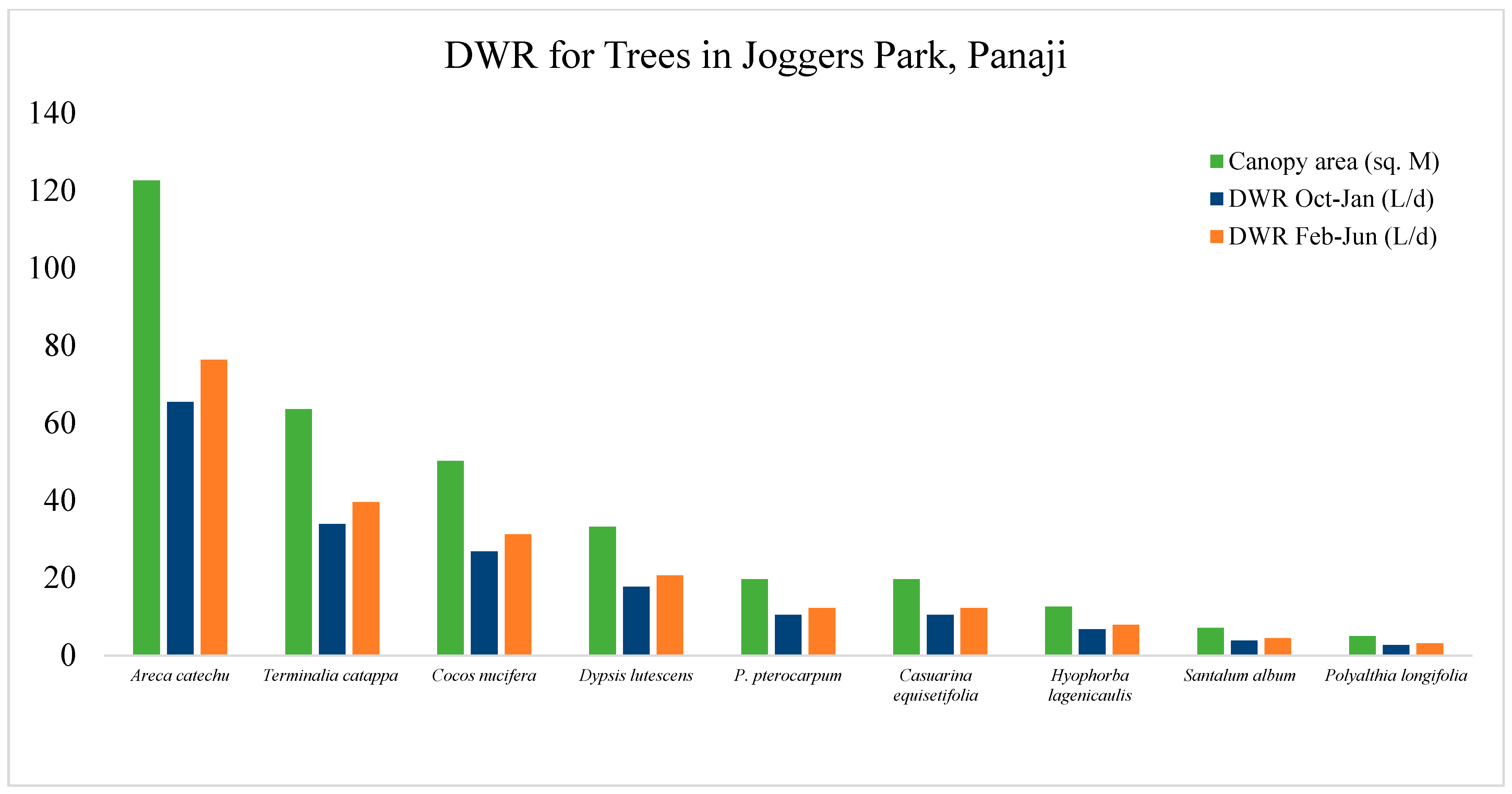
In most of these parks, watering is performed for three hours in the morning and three hours in the afternoon for covering only the groundcover (lawns) and ornamental plant–hedge along the walkways. About 20% of the total tall trees in Mahavir Park and those in the Range Forest offices of North and South Goa Districts are trimmed to a maximum height of 10 m to allow unobstructed passage of light signal from the lighthouse nearby. It is learnt that in addition to litter (dry leaves, twigs, prunes, mowed grass piles), over 30 tons of stem-wood is cut down annually from these trees. Mostly the Casuarina trees, ca 200 in numbers, stand in the path of the lighthouse signal beam. Joggers Park, created in 2002, is located on top of Altinho Hill in the central part of the city. Its hard laterite surface is leveled, suitably landscaped, and maintained to keep a largely plain surface for joggers, for a kindergarten playground and public amenity (toilet, parking space, and garden office) within an area totaling ca 700 m2.
2.3. Derivation of ETo for Panaji Region
The month-wise ET
o (mm d
−1) for the parks of in Panaji was derived using the formula provided by Snyder & Pruitt [
9]:
for daytime and
for night-time
Variables in these equations are, net radiation (
Rn, MJ m
−2 h
−1), ground heat flux density (
G, MJ m
−2 h
−1), psychrometric constant (∆, kPa K
−1), mean air temperature (
T, °C), wind speed (
u2, m s
−1), saturation vapor pressure (
es, kPa), vapor pressure (
e, kPa), and slope of the saturation vapor pressure at temperature
T (γ, kPa K
−1). Data on meteorological parameters viz., solar radiation, temperature, vapor pressure, and wind speed available in the literature were used (
Table 2 and
Table 3). The psychometric constant, slope of the saturation vapor pressure at temperature
T were either derived and, for reliability, compared with those of FAO Penman–Monteith datasets [
6].
2.4. Considerations for Assessing Water Requirements in the UGS
The DWR estimates can be improved by deriving the ETo for the regions. Therefore, three basic steps were followed in this study. Firstly, based on tree/plant density and diverse species grown, the parks were categorized as mixed type. As per the WUCOLS plant density (Kd) coefficients, the parks in Panaji fall into the category of high or mixed (1.1–1.3) type. Thus, a Kd of 1.2 might seem appropriate for the purposes of inference.
The next step was to recognize which of the landscape coefficients best describes these parks. In their study, Snyder et al. [
10] reviewed the WUCOLS and LIMP methods and identified the following coefficients as useful for deriving and practicing improved landscape management strategies. These are KL: landscape coefficient; Kmc: microclimate coefficient; Kp: plant species coefficient, which includes plant type and managed water stress, and Kd: plant canopy density. They stated that the K
p coefficients are
subjectively separated, depending on estimated water use of specific vegetation as, extremely low (<0.1), low (0.1–0.3), moderate (0.4–0.6), and high (0.7–0.9). Similarly, K
p values are also “determined subjectively based on the experience of the authors of WUCOLS”. In that, the K
p for any plant species with moderate water use during the post-monsoon months of October–January can be up to 0.6 and higher (at least 0.7) during the warm months, wherein the water use in the high humidity coastal location of Panaji can be higher at 0.7. With this consideration, these two plant factors were used [
11].
Briefly, temperature and season of the year, soil moisture content, soil’s water holding capacity, extent of tree root development, depth of root zone, root system-health, and tree species’ ability to resist drought are to be taken into account for working out the water requirement and frequency of watering [
12]. Several authors [
13,
14] have used the values of ET
o X PF X Canopy radius for estimating water requirement by a variety of groundcovers, shrubs, and trees. These authorities emphasize the importance of using appropriate factors of ET
o for landscape groundcovers and shrubs to achieve acceptable landscape performance. A median ranged ET
o value of 0.889 (equivalent to 0.35 as per Kjelgren et al. [
7]) derived and used in this study is much more valuable than picking any ET
o rate in the range of 0.16 to 0.48 supposedly holding good [
13] for most tropical tree species considered to experience.
Estimating landscape irrigation requirements is problematic because mixtures of plants, small plots of vegetation, and multiple microclimates make it difficult to measure or estimate the ETo. To arrive at a process that can be helpful in landscape water management practices, several approaches have been ongoing for providing guidelines [
5]. Among them, the Landscape Irrigation Management Program (LIMP) [
15], the WUCOLS [
16], and SLIDE rules [
7] rely on deriving appropriate coefficients for estimating landscape evapotranspiration for helping landscape managers in defining programs to improve landscape irrigation meet this requirement [
10]. Ideally, it would be better to calculate water requirement based on local ET
L or local reference evapotranspiration (ET
oL) by all counts. This ET
oL is an estimate of the ET
o for the local climate, “if it were possible to measure weather data over a well-watered grass surface to determine ET
o in the local climate” [
10]. Integrating these aspects to obtain a realistic picture of DWR was therefore attempted in this study,
2.5. Calculation of Water Requirements of Trees
Daily water requirement of different tree species, major ornamental shrubs maintained by pruning along both sides of the walk paths and of the turfgrass in the ground cover area was calculated based on the principles of Simplified Landscape Irrigation Demand Estimation (SLIDE) Rules [
7]. Unlike the complicated WUCOLS and LIMP methods, the SLIDE rules are used widely to estimate landscape plant water demand as products of evapo-transpiration (ET
o), canopy density, and plant factors (PF) which are discrete adjustment factors for broad plant types [
10] based on multiple observations. Since there are many different species of shrubs (<3 m tall) and trees (>3 m tall) in the parks covered for this study, ranges of height and canopy diameter for each species of trees were obtained from Mahavir Park, Ambedkar Park, and Joggers’ Park during the field visits. The help and knowledge of park maintenance staff was sought to ascertain the height and canopy dimeter estimates. The steps followed are shown in the flow chart below (
Figure 2):
Water requirements of isolated trees in the parks were calculated by appropriately substituting the formula: WR = ET
o × PF × (R × R × 3.14) × 0.623, as follows:
and
WR is water requirement, ET
oP (Panjim) is evapotranspiration factors (cm d
−1), and PF is Plant Factor for established landscape trees by following UCANR [
11]. Two plant factors were used: (a) 0.6 for all trees during somewhat cooler, mildly humid October–January and (b) 0.7 for all trees during the warmer February–June. R, tree canopy radius in meters; R × R × 3.14, area of tree’s canopy-equivalent floor cover; and ET
o in mm d
−1 were multiplied with this floor cover area to calculate the daily water requirement in liters. Irrespective of the canopy shape (triangular, irregular or tapering), its area for a given tree was estimated by projecting the two far end points of the canopy to the floor for a straight line distance that was noted as canopy diameter as per UCANR [
11].
2.7. Calculation of Water Requirements of Lawns (=Groundcover)
For estimating the daily water requirement of the groundcover, the “non-turf groundcover water demand calculator 2.0” (=NGWDC 2.0) was used [
11]. The ET
oP (0.889 cm or equivalent to 0.36 inches as per the American style) derived for this study was applied to obtain the DWR for the groundcover of Paspalum grass (mostly used as lawn grass in public gardens). The DWR works out to 42.53 for a groundcover area of 9.29 m
2 (=100 sq ft) (or 4.577 Ld
−1 m
−2). Using this rate, the DWR for groundcover was calculated for all parks from where the groundcover area was calculated.
Using these monthly day- and night-time averages of ET
oP (0.889 cm) derived in this study by following Snyder et al. [
10], the daily water requirements were worked out for the number of trees, area of hedge plants and groundcover calculated from all 17 parks of Panaji [
10] as per the weighted mean percentage of landscape spaces listed in
Table 3.


