Article

Evolution of Nuntași-Tuzla Lake Chemistry in the Context of Human Intervention

by
Gabriel Dobrica
1,
Carmen Elena Maftei
2,*,
Ionela Carazeanu Popovici
3,* and
Naliana Lupascu
4
1
National Administration “Romanian Waters”-Dobrogea Littoral, 900592 Constanta, Romania
2
Civil Engineering Faculty, Transilvania University of Brasov, 500036 Brasov, Romania
3
Applied Science and Engineering Faculty, Ovidius University of Constanta, 900527 Constanta, Romania
4
National Institute for Research and Development of Marine Geology and Geoecology, 900581 Constanta, Romania
*
Authors to whom correspondence should be addressed.
Water 2025, 17(10), 1482; https://doi.org/10.3390/w17101482
Submission received: 17 March 2025 / Revised: 10 May 2025 / Accepted: 12 May 2025 / Published: 14 May 2025
(This article belongs to the Special Issue Climate Change and Hydrological Processes, 2nd Edition)

Abstract

:
This paper analyzes the chemical evolution of Nuntași-Tuzla Lake (Romania) in the context of human intervention. Situated on the shore of the Black Sea, approximately 35 km north of Constanța, Nuntași-Tuzla Lake is part of the Razim–Sinoe Lake complex and a component of the Danube Delta Biosphere Reserve. This area has undergone significant transformations over the past 120 years: canalization of the connecting channels with the St. George arm, construction of polders for agriculture, closure of the connections to the Black Sea, and construction of the Razim–Sinoe irrigation system. After the irrigation system stopped working (around 2000), due to the isolation of the lake and the low flow coming from the two rivers that supply the lake with fresh water, it completely dried up in 2020. All these interventions have led to the ecological, hydrological, and chemical deterioration of the lake’s water. The main effects are (i) a decrease in water salinity and (ii) reduction in the production of sapropelic mud as the salinity decreases due to the influx of fresh water.

1. Introduction

The Water Framework Directive (WFD), formally known as Directive 2000/60/EC, is a key piece of European Union legislation that establishes a framework for protecting and managing water resources across the EU. The directive aims to achieve “good status” for all EU waters by setting out a comprehensive, integrated, and coordinated approach to water management [1,2]. The WFD aims to bring all water bodies, including rivers, lakes, coastal waters, and groundwater, to a “good status” by a set deadline (up to 2027). The directive mandates the prevention of any further deterioration in the status of water bodies, ensuring that their ecological and chemical quality is maintained or even improved [2,3]. As a result, it is necessary to (i) prevent any further deterioration of the state of water bodies, ensuring that their ecological and chemical quality is maintained or improved; (ii) encourage sustainable practices in using water to achieve a balance between the needs of the population, protection of the environment, and the development of economic activities; (iii) protect and improve aquatic ecosystems and, where necessary, improve the water quality through specific action plans; (iv) promote transparency by involving the public in water management decisions; and (v) achieve water management at the level of the hydrographic basin, crossing political borders, in order to manage water resources holistically [2,3].
Romania, as a member of the European Union, has integrated the WFD into its national legislation and established a monitoring network to regularly determine the chemical, ecological, and quantitative status of its surface and groundwater bodies. Romania’s implementation of the Water Framework Directive represents a significant step towards sustainable water management and environmental protection. While progress has been made in aligning national legislation with EU standards, ongoing efforts are needed to address challenges related to infrastructure, enforcement, and the impacts of climate change. Public participation and continuous monitoring remain critical components of Romania’s strategy to meet the WFD’s objectives and protect its water resources for future generations [3].
After the second report of Basin Management Plan (BMP) required by the WFD [2], the European Environment Agency (EEA) presented a report in which the authors [1] drew attention to the fact that only 40% of surface waters have reached a good ecological condition. After the third BMP, 55.9% of surface waters of Europe have reached a good ecological condition (WISE, 2024), which means an increase of 16%, approximately [4].
There are 1988 water bodies, from a total of 2014 water bodies, that have an unchanged status. From the second to the third BMP report, there were not too many changes regarding the ecological condition of the lakes (188 lakes from a total of 189 maintain the same status).
Nuntași-Tuzla Lake is a significant brackish water body located in the Dobrogea region of Romania, near the Black Sea coast. Over the centuries, the lake has undergone various natural and anthropogenic changes that have shaped its current state. Understanding the history of Nuntași-Tuzla Lake reveals an insight into its ecological importance, the challenges faced, and the efforts undertaken for its preservation and restoration [5]. Nuntași-Tuzla Lake is part of 32% of Romanian lakes that have not achieved “good” status recently [4].
The main objective of this paper is to determine the water quality using both the water quality index (WQI) and principles of the WFD. The specific objectives are (i) investigation of the limits and advantages of the Water Frame Directive (WFD), (ii) review of the evolution of the WQI, and (iii) review of human intervention in the Nuntași-Tuzla Lake basin. Reviewing the literature related to WHD implementation in Romania gives the possibility to identify gaps in the knowledge and can bring some novelty in research by using other methodologies, such as WQI.

2. Materials and Methods

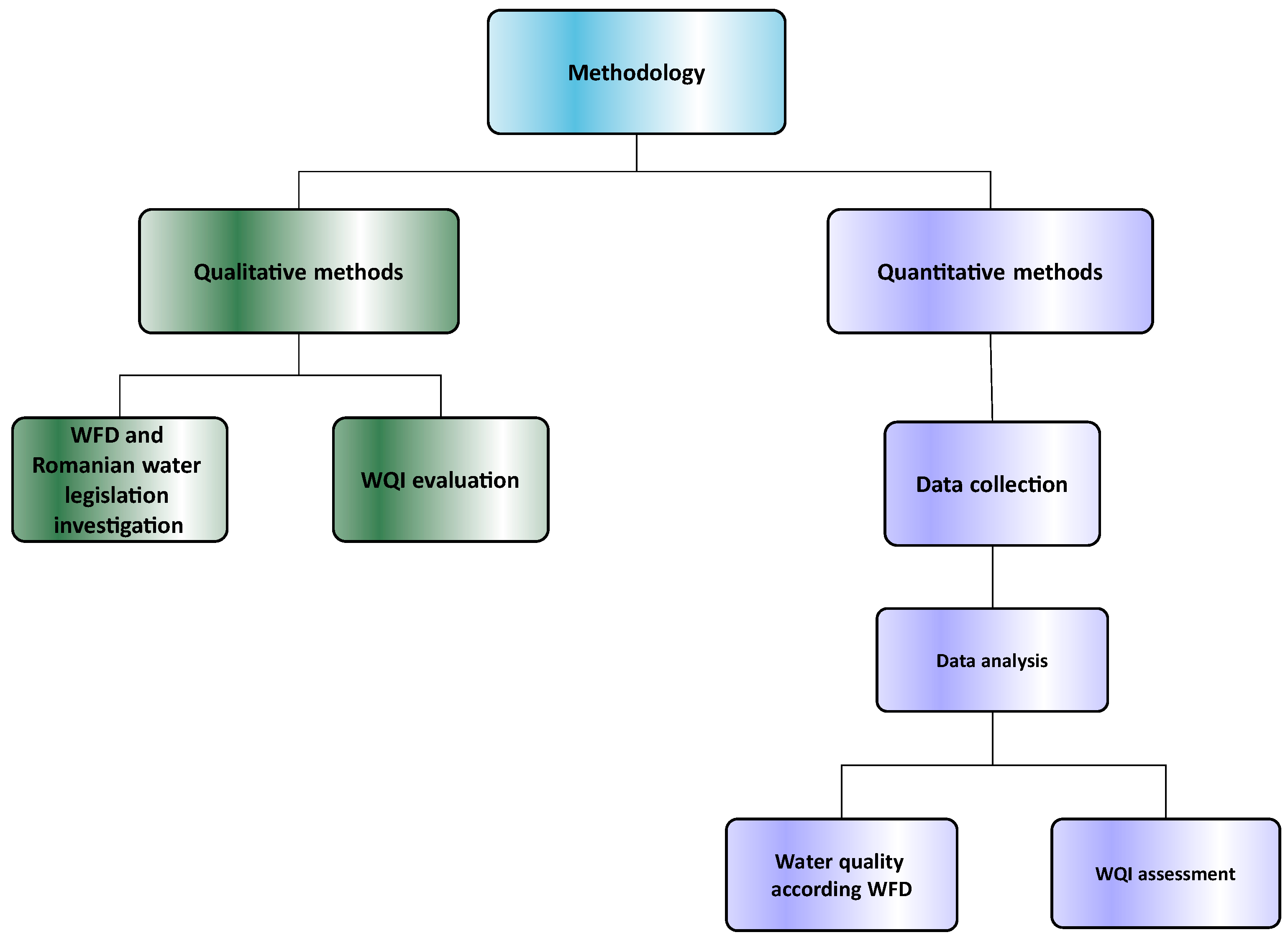
2.1. Methodology and Methods
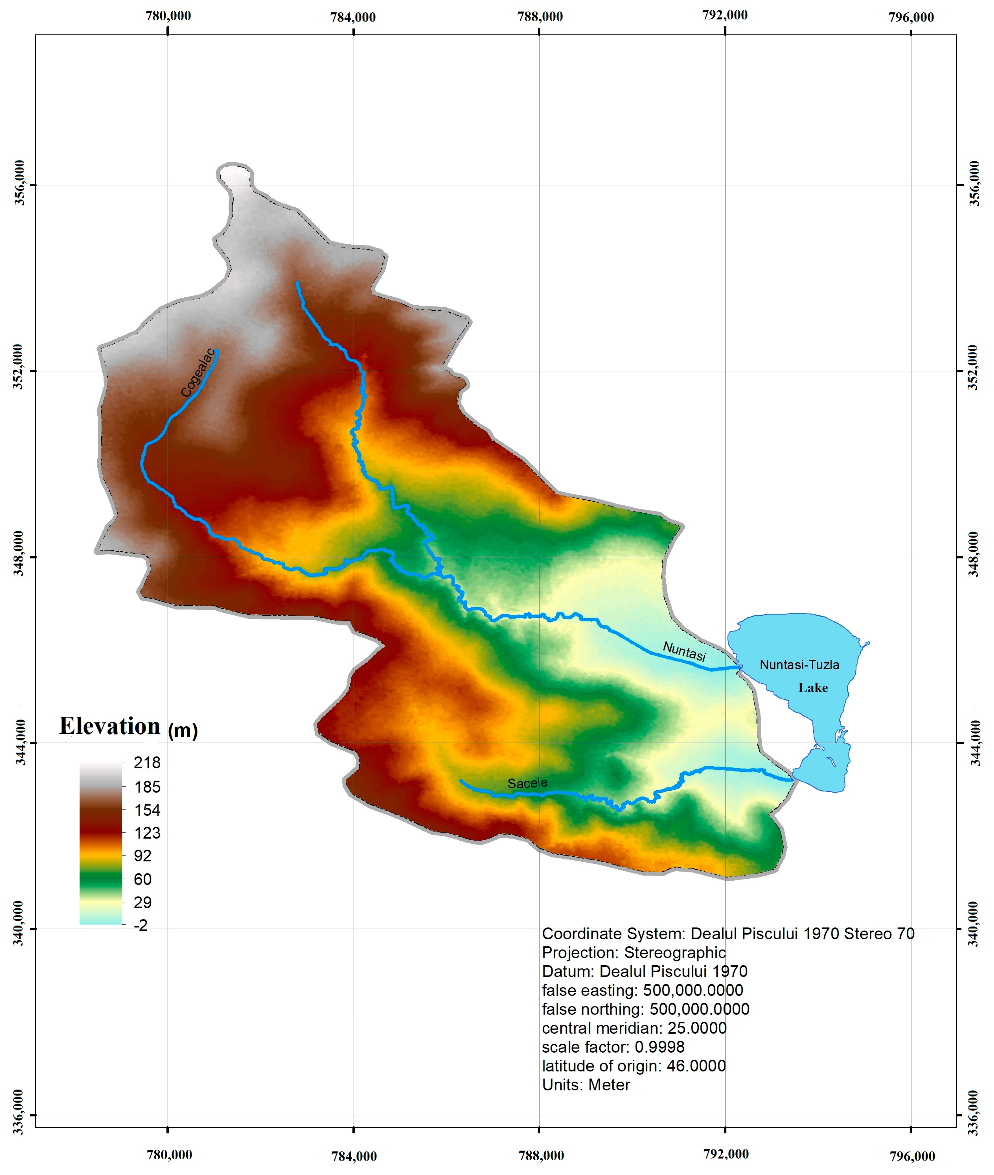
The flowchart of the methodology proposed in this paper is represented in Figure 1. The qualitative methods consist of (i) a discussion based on the specific literature of the Water Framework Directive (WFD) implementation into Romanian legislation related to water quality, its limits, and advantages, and (ii) the water quality index (WQI) method. The results are presented in the Results (Section 3.1). The quantitative methods consist of data collection and analysis, and the determination of water quality is conducted through two methods, WQI index calculation and WFD principle application. The two methods are presented in Section 2.2 Methods. The results obtained will be compared.

2.1.1. Study Area

The presented methodology will be applied to Nuntași-Tuzla Lake. Part of the Razim–Sinoe lacustrine system, Nuntași-Tuzla Lake is situated in the Dobrogea region on the Black Sea coast, 35 km north of Constanta. In ancient times, the Halmyris Bay was located here, on the shore of which a series of fortresses was built. The area has an important cultural and spiritual value due to the existence of the Histria citadel (which the ancient Milesian colony created in VII BC century) and the discovery of artifacts from the late Roman era in the Nuntași and Săcele areas. Nuntași-Tuzla Lake was once well known as the second therapeutic lake, after the Techirghiol Lake, for its sapropelic mud.
The climate is a temperate continental one with maritime influences. During the cold period of the year, influenced by the Black Sea, the temperature remains positive [6,7,8,9]. During the warm period of the year, the climate is influenced by the sea breeze. According to Dobrica et al. [6], for the 1965–2021 period, the multiannual precipitation was 458 mm, and the multiannual average of temperatures at the Jurilovca meteorological station was 11.3 °C.
The area studied is part of the Central Dobrogea Plateau, a subunit of the Istrian Plateau, and has a coastal plain aspect (Prispa Hamangia) developed between the Casimcea Plateau and the Black Sea, being a combination of sea plains (Sacele and Chituc), sandy barriers, and shallow lakes (Sinoe, Histria, and Nuntași). The DEM (digital elevation model) is presented in Figure 2.
The watershed of the lake is located at low altitudes (average altitude is 100.6 m, with a maximum of 218 m). The relief is stepped. The spaces between the valleys have a form of a high plain whose slopes have an eastern and southeastern direction. The average terrain slope is 3.7%. The watershed analyzed is a “mature” one, the relief is somewhat stable, the soil erosion or landslide processes are completed, and the material has been completely evacuated outside the basin [6].
From a hydrological point of view, the Dobrogea region is divided into two large basins: BH Littoral (71%) and BH Danube (29%). Nuntași-Tuzla Lake basin (code: ROLN05) is part of a littoral basin, located at the confluence of two rivers, Nutași and Săcele. According to Dobrica et al. [6], the annual Nuntași River discharge is 0.348 m3/s, and that of the Sacele River is 0.082 m3/s.

2.1.2. Data Series

According to SMIAR (Romanian Integrated Water Monitoring System), in the Dobrogea region, there are the following monitoring profiles: (i) Danube basin—23 monitoring points for rivers, 11 monitoring points for 9 lakes; (ii) Littoral basin—19 rivers, 11 lakes—33 monitoring stations; and (iii) 41 groundwater monitoring stations [10].
As we already mentioned, Nuntași-Tuzla Lake is situated in the Littoral basin, and starting in 1995, there were three monitoring points (Center Lake, camping baths, and Nuntași River connection). A data series was provided by the Romanian Water National Administration—Dobrogea Littoral Branch (RWNA-DLB). The records cover the 1981–2022 period, with some gaps (1983–1986, 1988–1994) due to unsystematic monitoring of the lakes. After 1998, the monitoring of chemical and biological parameters became a systematic one [11,12].
The following parameters are generally available: (1) physical, thermal, and acidification indicators, (2) oxygenation regimen (dissolved oxygen, CBO5, CCOMn), (3) nutrients, (4) salinity condition (only until 2009), (5) toxic pollutants (only since 2010), and (6) indicators of the eutrophication degree. Not all the parameters were measured in all the time periods and for all the sampling points. A discussion on the measured parameters will be presented in the Results section. Initially, samples were taken from 6–7 points of the lake. Since 1995, the number of sampling points has been reduced to three.
Some historical data related to chloride (Cl), sulfate (SO4−2), calcium (Ca2+), magnesium (Mg2+), and bicarbonate (HCO3) are available for different periods (e.g., 1934–1981). These data were collected from different documents [11,12,13,14,15].

2.2. Methods

In this work, two methods of classifying water quality are used: (i) the method stipulated in the WFD and implemented into Romanian legislation through the water law and other subsequent documents, explained in detail in Section 3.1, and (ii) the quality index of water (WQI).

2.2.1. WFD Method

WFD is the principal legislation of water policy in EU and introduces key principles for management and to ensure water quality in all EU countries. In this respect, a series of criteria/indicators is used to assess the status of the water bodies.
In Romania, the WFD requirements are implemented into legislation through the water law and subsequent documents. The ecological and chemical status are divided into 5 categories, from “High” to “Bad”, and 5 categories of trophy. Based on Romanian legislation, for the period and available data, the following elements are established: (i) the degree of eutrophication, (ii) the physical and chemical state, (iii) the biological state, and (iv) the ecological state of Nuntași-Tuzla Lake.
The eutrophication establishment degree is based on the use of the following indicators: total phosphorus, total mineral nitrogen, total biomass, and chlorophyll “a” [16,17,18,19,20,21]. The physical state is established by the pH indicator. The chemical state is established based on physics and chemical elements, namely, oxygen regimen and salinity. The biological state is established based on total phosphorus, total mineral nitrogen, biomass phytoplanktonic (FTK), and chlorophyll “a”. Starting in 2010, ABADL has provided a metrical index (IM) calculated for each biological element: phytoplankton, phytobenthos, and macroinvertebrates. The ecological state of Nuntași-Tuzla Lake is based on the “one out–all out” principle. This principle is applied to each indicator to establish the general ecological state. The “one out–all out” principle was imposed by the WFD to assess the ecological status of surface water. This principle expresses that the overall status is selected based on the worst ecological status.
The calculation of the indicators is performed differently, depending on the volume of data selected: if the length of the data series is less than 30, then the evaluation is based on the arithmetic mean of the measured values; if it is greater than 30, the evaluation is based on the 90-percentile value, respectively, 10 percentiles for “dissolved oxygen”.
Additionally, for the 1981–2009 period, the state of salinity was determined based on the chloride, sulfate, calcium, and magnesium concentrations. For the 2010–2023 period, the priority substances state was determined.

2.2.2. WQI Method

The water quality index (WQI) is a valuable tool for monitoring and managing water resources, ensuring they remain safe for human use and ecological health. The WQI simplifies complex water quality data into a single number, making it easier for policymakers, scientists, and the public to understand a water body’s health. WQI is typically calculated using various water quality parameters, each of which is assigned a weight based on its relative importance to overall water quality [22,23,24,25].
For this paper, based on data availability, the WQI selected is the one proposed by Brown [24], namely, “Weighted Arithmetic Water Quality Index Method” (WaWQI). According to the methods proposed, the equation used to calculate WQI is as follows:
W Q I = i = 0 n Q i · w i i = 0 n w i
where n is the number of parameters; Qi is the evaluation scale; and wi is the weight of each parameter.
The evaluation scale formula is as follows:
Q i = V i V 0 S n i V 0
where Vi is the concentration value measured for each parameter considered; Vo represents the ideal value of concentration in pure water, which is 7 for pH and approximately 0 for all the other parameters; and Sni is the standard concentration value for each parameter selected; in this case, we selected the value corresponding to “good” quality from the guideline.
The standard concentration value for the parameters selected in this paper is presented in Table 1, and the scale value for WQI is presented in Table 2. The determination of weight, wi, is based on inverse proportionality to the standard concentration.
S n i   ( w i = k S n i )
where ki is the constant of proportionality.

3. Results

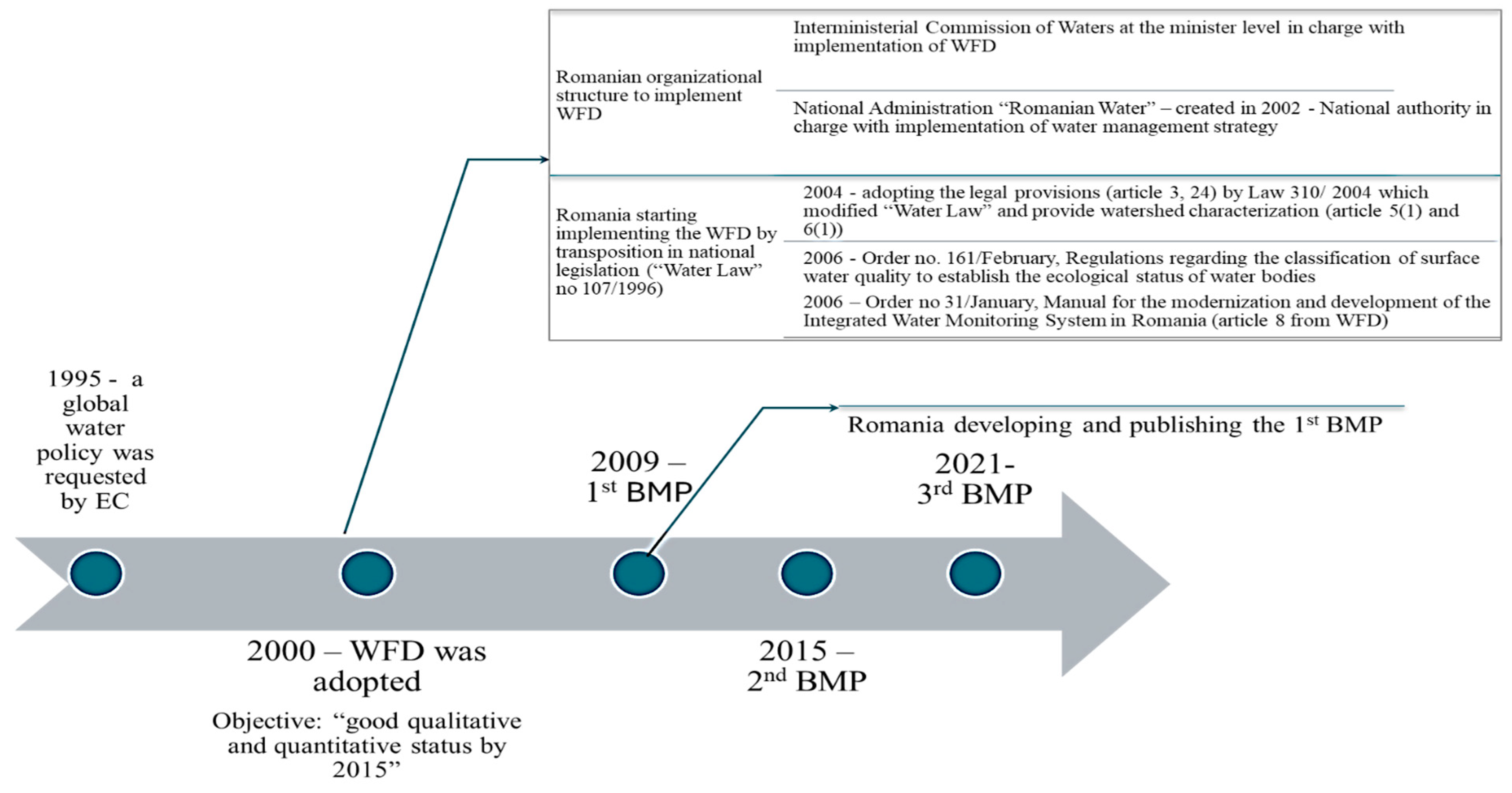
3.1. WFD and Romanian Legislation Related to Water Quality

The Water Framework Directive (WFD) represents a comprehensive and integrated approach to water management in the European Union. It aims to achieve good water status for all water bodies, promote sustainable use, and protect aquatic ecosystems through River Basin Management Plans, monitoring, and stakeholder involvement. Since it led to significant improvements in water quality and management, ongoing challenges require sustained efforts and adaptations to ensure the objectives are met. The implementation tool of the WFD, regulated by Article 13 and Annex VII, is represented by the management plan of the river basin (BMP). The technical documents, namely, “guidance” documents, are available on the CIRCABC (Communication and Information Resource Centre for Administrations, Businesses and Citizens) website (available online: https://circabc.europa.eu/ (accessed on 15 May 2024)). There are 34 guidance documents, and their role is to assist those involved in the WFD implementation. Figure 3 presents a schematic evolution of WFD application in Romania.
After the WFD adoption (2000), the Romanian administration started to modify the Water Law (no. 17/1996) and create the organizational structure to implement the directive. Introduction of the WFD in national legislation started in 2004 by Law 310/2004, which modified Water Law (no. 17/1996) when Romania adopted legal provisions (articles 3 and 24 from the WFD). The law no. 310/2004 also provides the (i) “Scheme of the watershed with their boundaries”, (ii) conditions for achieving water and aquatic ecosystem protection objectives for all surface and groundwater bodies, (iii) a list of hazardous substances, (iv) a list of principal pollutants, and (v) economic analysis. In this way, the legal framework for the application of articles 4 (1 a and b) and 5 (1 and 2) was created.
Romania completed the Romanian Basin Management Plan (RBMP) (Article 13) and developed the monitoring program (Article 8) between 2004 and 2009. In the next period, several ministry orders were adopted to introduce (i) regulation regarding the surface water quality classification to establish the ecological status of water bodies and (ii) a manual to develop the Integrated Water Monitoring System in Romania (compliance of article 8). The Romanian Integrated Water Monitoring System (SMIAR) was organized by the water law and restructured according to the WFD.
In January 2006, a guide for the modernization and development of SMIAR was adopted to ensure the implementation of SMIAR through OM No. 31. According to the legislation adopted, two main types of monitoring are used within SMIAR: (i) observation monitoring and (ii) operational monitoring. Six subsystems are monitored: rivers, lakes, transitional and coastal waters, and groundwater. Additionally, in February 2006, a regulation regarding the classification of surface water quality was adopted to ensure the ecological establishment status of water bodies. Observation monitoring has the role of assessing the state of water bodies at the level of all water bodies and is carried out every year based on a management plan identified as not being at risk of not reaching the environmental objectives.
The operational program aims to establish the state of water bodies that present the risk of not meeting the environmental objectives. The quality elements and measurement frequency used to establish the state is well explained in both the Romanian legislation and the Romanian Basin Management Plan (RBMP—chapter 6) and refers to (i) biological elements; (ii) hydro-morphological elements; (iii) physics and chemical elements; (iv) priority substances; (v) priority substance—sediments; and (vi) priority substance—biota. The groups (iv), (v), and (vi) were introduced in line with Annex I of Directive 2008/105/EC, modified by Directive 2013/39/EU, article 3 (6), and article 3 (2), respectively, which were transposed into national legislation by H.G. 570/2016; they are measured only in the case of the existence of pollution sources and/or their identification within the screening analysis.
Based on those indicators, according to OM 161/2006, the ecological state of the water lake is divided into five categories: very good (I), good (II), moderate (III), poor (IV), and bad (V). For lakes, the degree of trophy will be established. OM 161/2006 also establishes five degrees of trophy for lakes, namely, ultraoligotrophic, oligotrophic, mesotrophic, eutrophic, and hypertrophic (article 1 (5)). According to article 3 (4), the elements of chemical and physical–chemical quality in the group “Salinity” represent substances of natural origin and do not indicate pollution.
The general principle for establishing the ecological status of water surfaces stipulated in Appendix 5 of the WFD is “one out–all out”, which means that the most unfavorable situation is selected.
Due to the measures taken, the second BMP shows that Romania achieved a good status for 60–70% of the surface water bodies [1]. But 30–40% of the surface water (including lakes) still fail to achieve “good” ecological status. This is also the case with Nuntaşi-Tuzla Lake.

3.2. Human Intervention in Nuntași-Tuzla Lake Basin
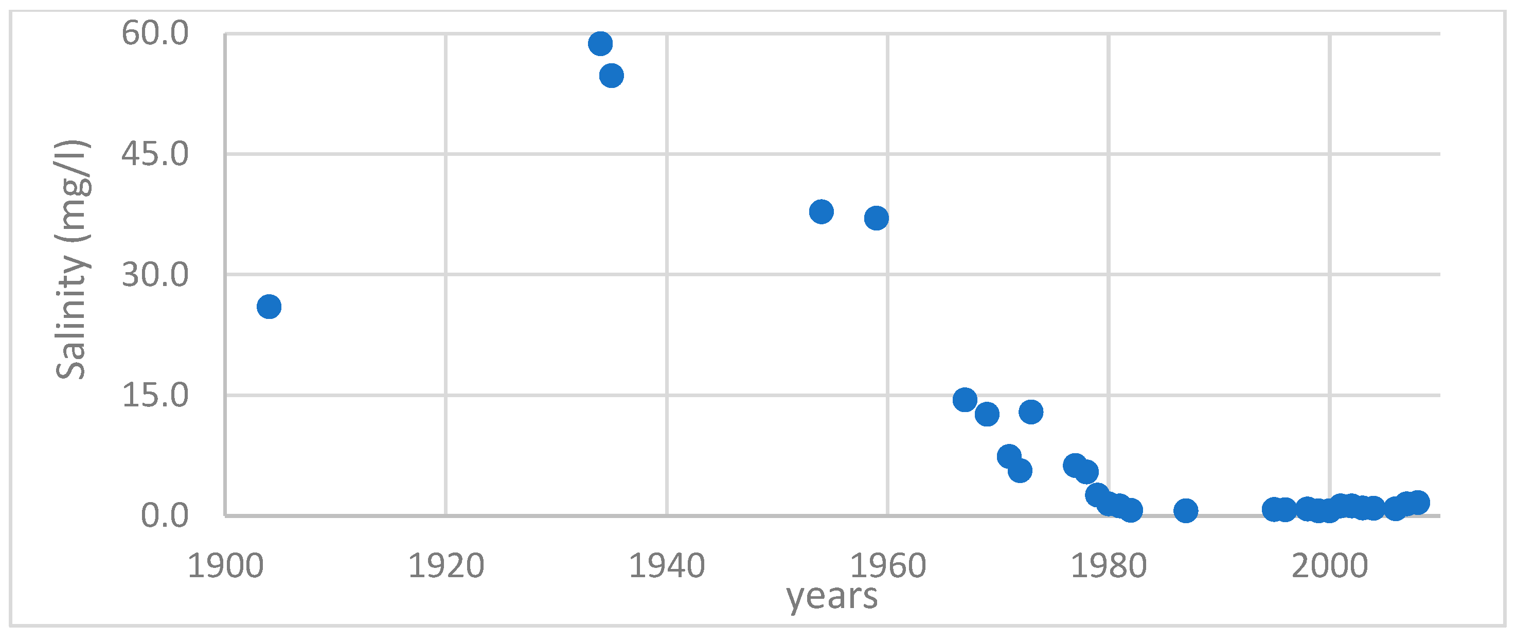
The first information about the Nuntași-Tuzla Lake was provided by Ionescu MD [15]. Accordingly, this lake was called Tuzla at that time; the word means “with salt” in Turkish. He also mentioned a value of salinity of 26 mg/L. More than this, he stated that the main use of Lake Tuzla was the production of salt “by capture”, given that the lake had salty water. Until 1897, there were five salt deposits on the shores of lake [15]. In 1924, Poruciuc [26] referred to the same lake by naming it the Tuzla–Sinoe or Duingi Lake (today Nuntași). He stated that the lake communicated with the Black Sea through Istria and Golovita Lakes through the mouth of Portița and had 2000 hectares, but it was still isolated from freshwater sources, having no freshwater springs. For this reason, having a small depth and a high salinity (unspecified) leads to the deposition of salt. He declared that a deposit of 200,000 kg of salt was found in the area, left by the Turks to the Romanian authorities, after the annexation of Dobrogea in 1879.
In 1928, Bratescu C [5] mentioned in his work that Tuzla Lake (the name is kept) communicated with the Sinoe Lake through a “mouth/gate” between the Istria hill in the north and the Histria fortress in the south. In his opinion, the surface of the lake was 1600 hectares, and the lake’s water was salty. The first scientific information about the morphological characteristics of the Nuntaşi-Tuzla Lake was provided by Breier [11]. In her work, Braier established the morphometric characteristics of Nuntași-Tuzla Lake as follows: the surface is 1050 hectares; the water volume is 9.28∙106 m3; the length is 6.2 km; the width varies between a minimum of 1.7 and a maximum of 3 km; the maximum elongation coefficient is 2.00; the average depth is 0.6 m, the maximum being 1.0 m; and the slope of the lake bottom is 0.0020 m/m. Breier [12] also provided some information about the water chemistry, classifying the lake as one with polyhaline waters with a salinity in the range of 10–17 g/L.
From this brief historical presentation, we conclude that the studied lake had water with high salinity. The lack of precipitation in the summer and the high temperatures lasting until September led to a negative hydrological balance, which determines the decrease in water in the lake and its salinization. As was already mentioned, the Nuntași-Tuzla Lake is a part of the Razim–Sinoe lacustrine system, which is connected to both the Black Sea and St. Gheorghe Branch.
Gâstescu and Braier [13] stated that the main canals that connect the St. Gheorghe branch are Lipovenilor, Dunavăț, and Dranov. The connection with the Black Sea is made through the so-called “gates” or “periboine”. These are Gura Portiţei, in front of Goloviţa Lake; Periteșca gate; Leahova gate, in front of Razim Lake and in front of Sinoe Lake; and Periboina and Edighiol gates. This area has been the subject of major hydrotechnical works over the past 120 years, which can be divided into two great categories: (1) the canalization phase and (2) the development of the Razim–Sinoe irrigation system. The canalization phase was very well described by Pons L.J. [27] and it refers to (i) canalization of the Sulina Branch to ensure its navigability (1889–1902), (ii) canalization of the canals (including Dranov and Dunavat (1903 and 1912, respectively) to ensure the fisheries, connections between smaller canals, connections between the Danube branches (Chilia, Sulina and St. George) and the Razim–Sinoe lacustrine systems (1950–1965), and canalization of the St. Gheorghe Branch to ensure the navigability (by regularization) and fresh water supply of the Razim–Sinoe irrigation system (1965, approximately).
The description of the Razim–Sinoe irrigation system development was described by Grumezea et al. [28]. This irrigation system was first used in 1974–1975; the studies and design activity of it were achieved in the 1969–1971, period and execution of it was carried out during the 1971–1974 (1975) period. The development of this irrigation system supposed the isolation of lakes from the Black Sea. To complete these three major hydraulic projects, the following steps were necessary: (i) closing communication between lagoons (Razim, Golovita, Zmeica, Babadag) and the Black Sea, which is supposed to be nearest to Portita Gate, and creating dammings to consolidate the coastal area (littoral belt) so as to prevent deterioration of lake shorelines; (ii) controlling the communication between Razim and Sinoe Lakes to ensure the discharge of the fresh water surplus of Sinoe Lake (by Edighiol and Peribiona gates) and the navigation on Sinoe and Razim Lakes; (iii) arranging the lagoon area as a great reservoir by the canalization of the Dunavat, Dranov, and Mustaca canals (Figure 4), which ensure the communication between St. Gheorghe Branch and the lagoon area; those canals ensure an average discharge of 80 m3/s.
In a 1973 publication, the authors drew attention to the elaborated development plan for the Razim–Sinoe irrigation complex that would “sweeten” the waters of the lakes in about two years and would be able to be used for the irrigation of about 123,000 ha in the NE of Dobrogea [13].
Based on salinity data, the evolution of this parameter is presented in Figure 5. Starting with 1981, the water chemistry reached the limits of the necessary amount for irrigation (1 g/L). Therefore, the Nutasi-Tuzla Lake remains isolated, and the canal between Istria Lake and Nuntași-Tuzla Lake was closed, being silted since 1976 [12].
Dobrica et al. [6] stated that the maximum exploitation period of the irrigation system was 1981–1989, and starting with 1989, the system worked only partially and was completely closed in 2006. This also affects the evolution of the Nuntași and Săcele Rivers’ flow rates (Table 3).
Table 3 shows that during the maximum period of the operation of the irrigation system (1981–1989), the average multiannual flow of the Nuntași River is 1.4 times higher than that of the previous period (1965–1980). This increase is due to the infiltration resulting from the water used for irrigation.
After 1989, the multi-year discharge for the period of 1990–1997 returned to the baseline (1965–1980) and continued to decline, reaching a dangerous level (6.75 times lower than the average annual discharge for the period of 1965–1980). After closing the irrigation system and reducing the discharge rates on the two rivers, the Nutasi-Tuzla Lake level began decreasing, which led to a decrease in the lake surface. Research conducted in the past reveals that during the irrigation period, the production of sapropelic mud decreased due to decreases in salinity [14].

3.3. Data Analysis

Based on the methodology proposed, four time series of data were established to evaluate the degree of eutrophication, corresponding to the indicators used (total phosphorus [mg/L], biomass [mg/L], mineral nitrogen [mg/L], and chlorophyll “a”; there are only three years with registered values). Generally (86%), the lake is hypertrophic, 7% eutrophic, and 7% mesotrophic.
Physical components refer only to the pH parameter. The pH of the Nuntași-Tuzla Lake varies, depending on several factors, including its salinity, temperature, and the presence of organic material. However, as a saltwater lagoon, the pH is typically expected to be in the range of 6.5 to 8.5 [21]. This range is generally alkaline due to the dissolved salts and the buffering capacity of carbonate ions present in the water.
In recent years, environmental changes, such as droughts, reduced water inflow, and human activities, have impacted the lake, possibly leading to fluctuations in its pH levels. These changes could cause the pH to deviate from the typical range, potentially affecting the local ecosystem. From a total amount of 31 recordings, only 23% are situated in the 6.5–8.5 range; the rest of the values (77%) are outside a value of 8.5.
Oxygen regimen refers to dissolved oxygen (DO) [mg/L], biochemical oxygen demand—BOD5 [mg/L], and chemical oxygen consumption—CCOMn [mg/L]. The level of dissolved oxygen in the Nuntași-Tuzla Lake is a critical indicator of the lake’s health and its ability to support aquatic life. Dissolved oxygen levels can vary significantly depending on factors such as temperature, salinity, organic load, and water circulation [17,18,19,20,21,27,28,29,30,31].
In saltwater or brackish environments like Nuntași-Tuzla Lake, dissolved oxygen levels are typically lower than in freshwater due to the higher salinity, which reduces the solubility of oxygen in water. Given these factors, the dissolved oxygen in the Nuntași-Tuzla Lake might be relatively low, particularly in warmer months or during periods of high organic decomposition.
The dynamics of dissolved oxygen are in an interdependent relationship with the intensity of biochemical and chemical oxygen consumption processes in water, which reflects the level of pollution of an aquatic ecosystem with organic substances.
The biochemical oxygen consumption (BOD), expressed by the BOD5 indicator, indirectly indicates the loading of water with biodegradable organic substances. This depends on the quantity and biochemical decomposition capacity of the existing organic substances in the water, under the influence of oxygen consumption. CCOMn is a variant of BOD5 testing that uses manganese as the oxidizing agent to measure the carbonaceous component of organic matter in water. It is particularly useful for assessing the organic carbon load in water bodies and industrial affluents, with applications in water treatment and environmental monitoring [21]. The evolution of all those parameters is presented in Figure 6.
As Figure 6 shows, of 31 DO records, 17 (58%) represent a high status, 26% good, 13% moderate, and the rest poor (3%). No bad condition was registered. Concerning BOD5, of 29 records, 21 (72%) represent “poor” conditions, 14% moderate, 13% good conditions, and 3% bad conditions. No high condition was registered. As for CCOMn, of 16 records, 9 (56%) represent moderate status, 31% represent poor status, and 13% represent good status. No high condition was registered.
The nutrient levels in the Nuntași-Tuzla Lake, like in many other coastal lagoons, are important for understanding its ecological health and potential for issues like eutrophication. The key nutrients of interest are typically nitrogen (in forms such as nitrates and ammonium) and phosphorus (primarily in the form of phosphates). Nitrogen can enter the lake from various sources, including agricultural runoff (fertilizers), atmospheric deposition, and the decomposition of organic matter. In Nuntași-Tuzla Lake, nitrogen often presents as nitrates (NO3), nitrites (NO2), and ammonium (NH4+). Elevated levels of nitrogen can lead to algal blooms, which, upon decomposition, can decrease oxygen levels, causing hypoxic conditions that are harmful to aquatic life. Phosphorus typically enters the lake from runoff containing fertilizers, detergents, and natural sources, like sediment erosion. In coastal environments, phosphorus is usually present in the form of phosphates (PO43−) [21,29,30,31].
The nutrient regimen of Nuntași-Tuzla Lake is determined based on the following indicators: ammonium (NH4+) [mg/L], nitrate (NO3) [mg/L], total nitrogen (N) [mg/L], phosphate (PO43−) [mg/L], and total phosphorous (P) [mg/L] (Figure 7). The nutrient classification according to OM161/2006 is presented in Table 4.
Nuntași-Tuzla Lake’s salinity is an important environmental parameter that requires ongoing observation to ensure the ecological stability of this unique coastal lagoon. The salinity of Nuntași-Tuzla Lake varies depending on several environmental factors, but it is generally recognized as a saline lagoon. The salinity indicator is based on the concentration of chlorides (Cl), sulfates (SO42−), calcium (Ca2+), and magnesium (Mg2+). The values are measured in mg/L [31,32]. The variation of these indicators is presented in Figure 8, and the classification of the salinity indicator is presented in Table 5.
The salinity of Nuntași-Tuzla Lake has experienced significant changes, particularly due to human interventions, such as the construction of dikes and channels, which have altered water flow and exchange with the Black Sea. This has led to periods of both increased and decreased salinity, impacting the lake’s flora and fauna.

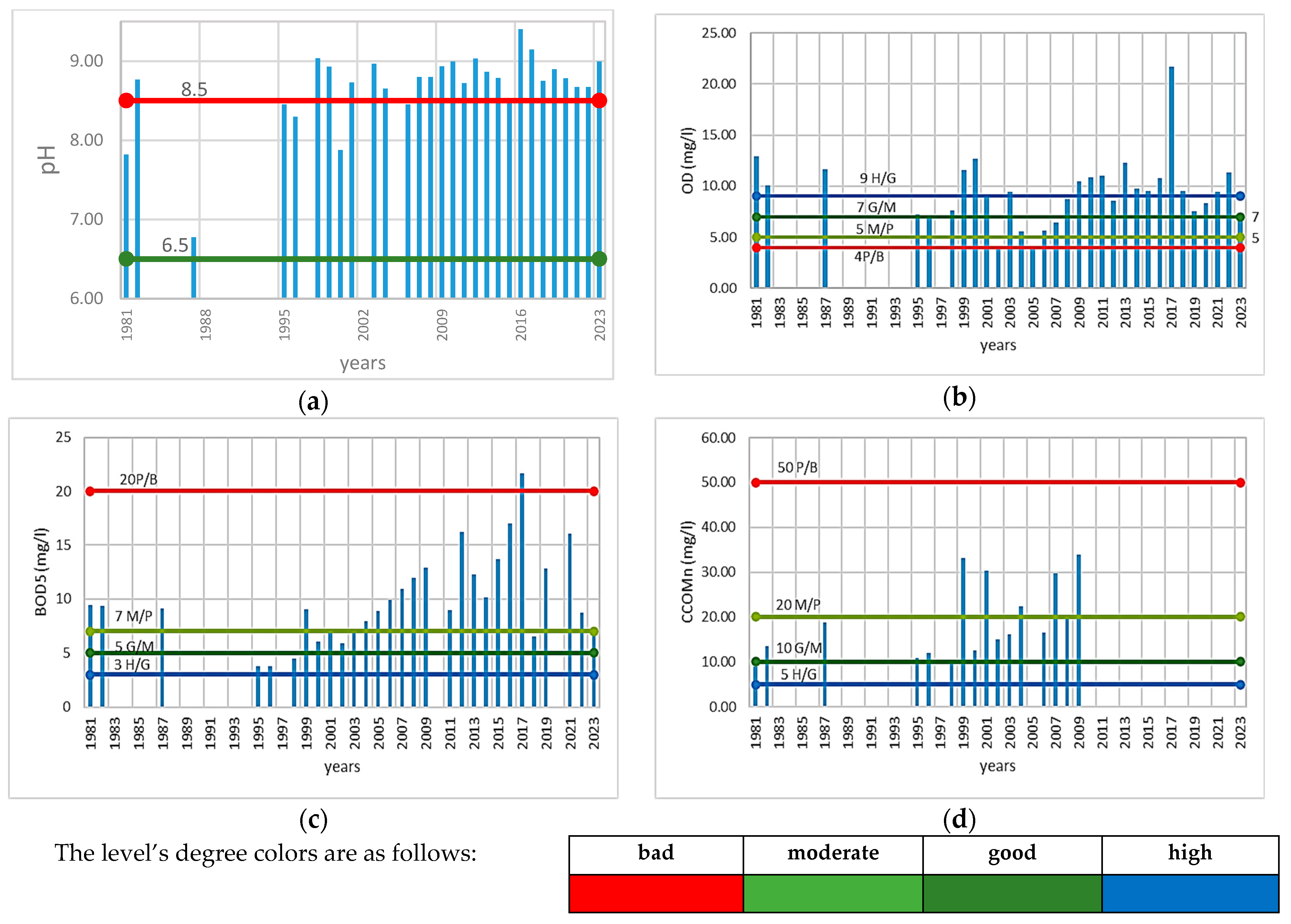
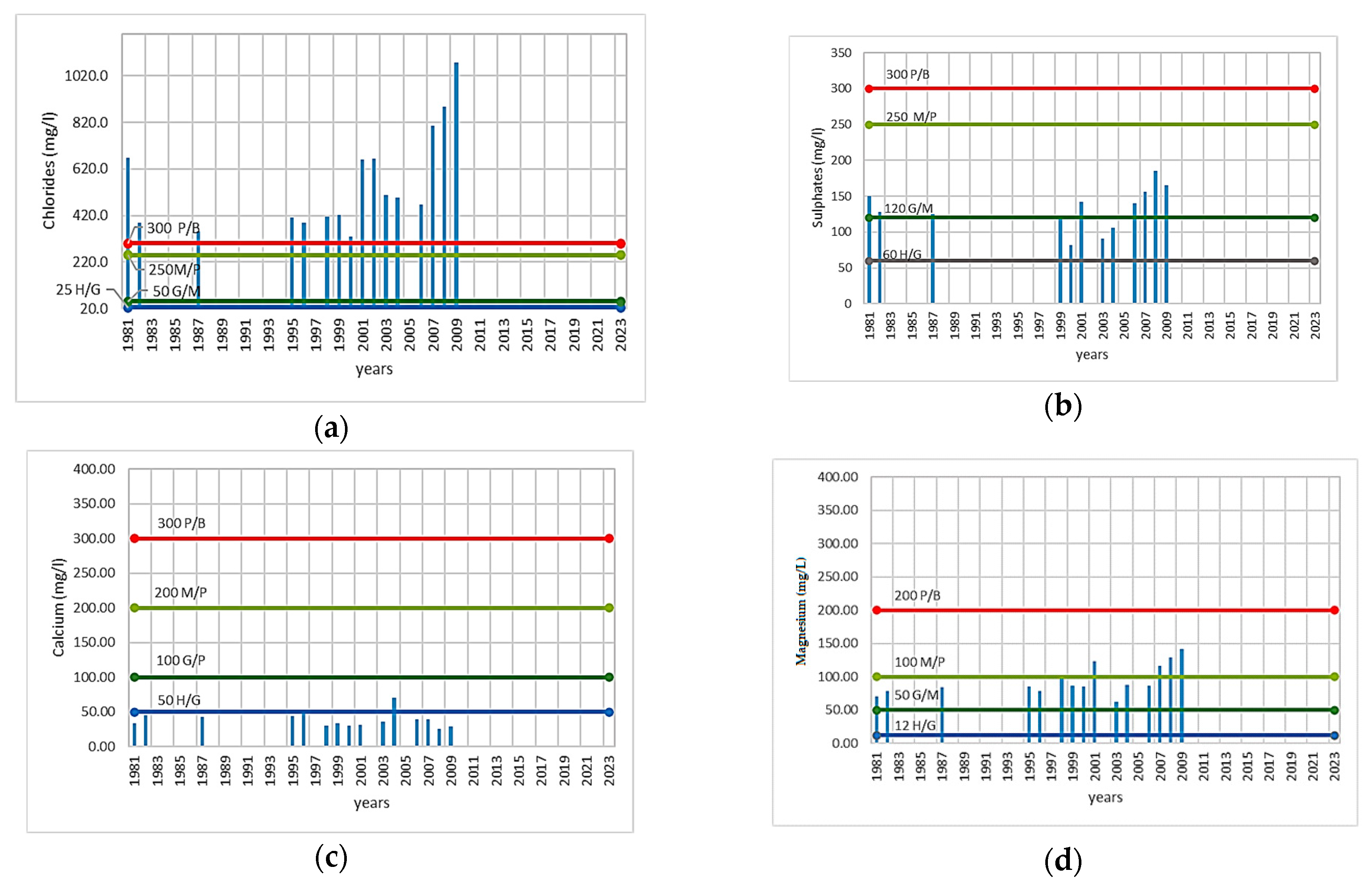
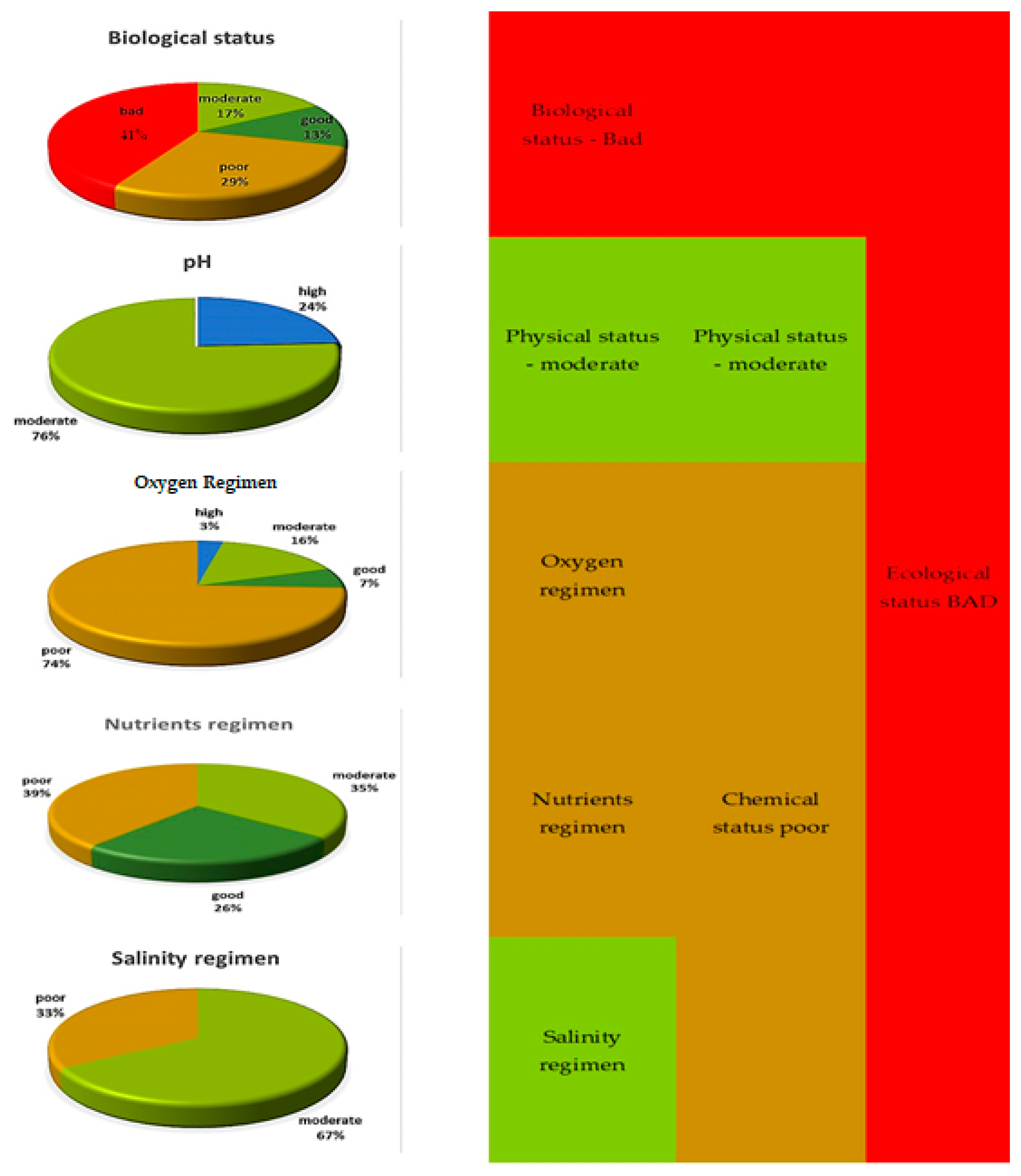
3.4. Water Quality Determination According to the WFD

Nuntași-Tuzla Lake, a part of the larger Razim–Sinoe lagoon complex in Romania, has faced various ecological challenges over the years. The lake is important both ecologically and economically, but its status has been influenced by a combination of natural and anthropogenic factors. The ecological status of Nuntași-Tuzla Lake for the entire study period is presented in Figure 9.
Generally, throughout this period, the lake had a biological status of “bad” (42%) This classification result could be divided into two periods: (i) 1981–2009, when the biological status was generally bad (63%), and (ii) 2010–2023, when the biological status was generally “moderate” (31%). Otherwise, the ecological status percentages are equal: 23% for each category: “good”—2014–2016, “poor” (2010, 2021–2022), and “bad” (2018–2020). For the year 2023, the biological status could not be determined, and the ecological status, which is “poor”, was based on physical–chemical elements.

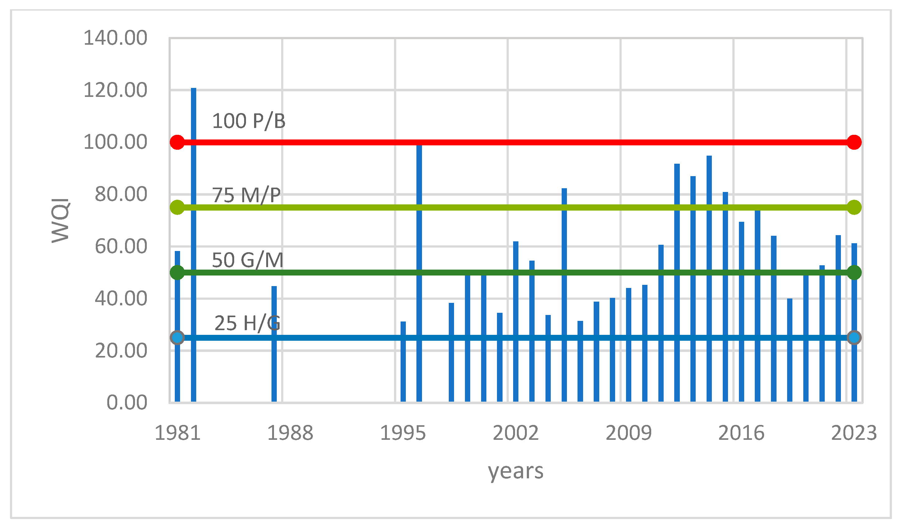
3.5. Water Quality Index Determination

Based on the equations presented in the Methods section, the variation of the WQI is presented in Figure 10.
Figure 10 shows that only in 1982, the WQI was greater than 100, which means “bad” conditions. Otherwise, out of 31 WQI values, 39% represent “good” conditions, 35% represent “moderate” conditions, and 23% represent “poor” conditions. It should be remembered that the series representing the salinity indicators is for the period 1981–2009 (with the gaps already indicated) and the one relating to the biological elements is for the period 2010–2023.

4. Discussion

The WFD implementation has had a great influence on the water management systems of EU countries by introducing the concept of watershed management [33]. This was not the case in Romania, which had this concept introduced in the old Water Law no. 8 of March 1974. To assess the ecological state of water, the WFD introduced an integrative method in the evaluation of water quality by establishing its quality based on several biological indicators, at the expense of chemical ones. Appendix V of the WFD outlines a main group as “quality elements”, the biological one and two supporting ones, hydro-morphological and physico-chemical. This principle was implemented in Romanian legislation, as it is explained in the Results section. The use of the principle “one out–all out” leads to a restrictive ecological status classification system in relation to the definition of environmental objectives. It means that a body of water cannot achieve good ecological status if any element has a value that deviates from undisturbed conditions. The big advantage is that if an indicator is missing from a group of indicators, the status could be determined based on the others. For example, as is shown in Figure 6, the DO data series has 31 values registered, BOD5 has 29 values registered, and the CCOMn data series presents some gaps (no values registered for the 2010–2023 period); in this condition, the oxygen regimen status is determined based on DO and BOD5 conditions.
In the early years of application of the WFD methodology, a major obstacle was the fact that no consistent biological datasets were available for lakes, in particular. This impediment was resolved by the creation of geographical groups whose aim was to harmonize the methodologies used by the member states. In line with this, Romania participated in an “intercalibration exercise” with Bulgaria and Hungary and established a harmonized methodology to evaluate the phytoplankton [34] by the new Decision of European Commission [3].
Regarding the monitoring systems, through the WFD, the existing gaps in the monitoring systems were addressed by introducing the two types of monitoring programs: surveillance and operational. Unfortunately, there are no national websites dedicated to the monitoring system. For example, the Romanian system, SMIAR, is not as transparent as the National Network for Monitoring Air Quality (RNMCA), which limits the follow-up by the public of the general water condition. Discussing Nuntași-Tuzla Lake’s ecological condition, based on data provided by RWNA-DLB Constanta, the ecological status for the entire period is “bad” (Figure 10). This period could be divided into two distinguished periods: 1981–2009 and 2010–2023. The period of 1981–2009 is based on a large lack of records; only in 1982 and 2007–2009 are there records regarding the types of phytoplankton that would lead to the possibility of calculating the metric index. In the rest of the periods, there are only records with biomass. There are no determinations regarding the other biological elements (phytobenthos and macroinvertebrates). For 2023, there are no registrations, so the ecological status is based on physical–chemical elements. In this condition, we consider that for the 1981–2009 period and the year 2023, the ecological condition is based only on chemical elements, and for the 2010–2022 period, it is based on biological elements. The results obtained show that the ecological status is “bad” for the 1981–2009 period, “moderate” for the period of 2010–2022, and “poor” for 2023. The “bad” ecological status of the 1981–2009 period is due to the chloride conditions, which were “bad” (Figure 8a). But in this case, salinity is not a pollutant. The high salinity values are due to natural conditions. If the ecological conditions determined based on the salinity regime were to be abandoned, then the ecological condition for the period of 1981–2010 would fall into the poor class. Even if the 2010–2022 period is declared “moderate”, the oxygen regimen conditions for the 2011–2017, 2019, and 2021–2023 periods are “poor”. This poor condition is due to the BOD5 indicator; the values of this indicator are “poor” for the entire period (2004–2022). A rise in BOD5 indicates a high degree of organic contamination in water bodies. So, could the ecological status be declared as “poor”? If the answer is “yes”, it means that the lake was in poor condition for the entire period. The decision according to which the ecological status assigned to a water body depends on the most seriously affected quality element can lead to anomalies. In this case, Nuntași-Tuzla Lake could not achieve a ”good” ecological status due to the chloride concentration, which, starting in 2001, has been increasing.
The studied lake presents some particularities: (i) it has a small water depth and was isolated from the rest of the lacustrine system (Razim–Sinoe) for a long time (1976–2020), which could lead to degradation of the oxygen regime. (ii) It was strongly affected by anthropogenic measures (the operation of the irrigation system), which led to the change in salinity and the disappearance of the sapropelic mud. Related to sapropelic mud, Bulgareanu showed in 1974 that the bottom deposit in the lake consists of black or black-gray, unctuous, sapropelic mud about 0.6 m thick [35]. These deposits were mostly located in the center of the lake, below the loess deposits on the western shore, and less on the eastern shores. In 1982 (ICPGA, 1982), the research authors stated that Nuntași-Tuzla Lake is the second therapeutic lake in Romania due to its sapropelic mud reserve [14]. Based on data recorded in 2002, Dragan-Bularda et al. [36] considered that the sapropelic mud from Nuntași-Tuzla Lake belongs to less active mud, which diminishes its therapeutic qualities. The anthropic impact together with climate changes (increasing temperatures after 1997 up to 0.8 °C [7]) led to the complete drying of the lake in August 2000 [6,8,10]. Șerban et al. [10] showed that in the summer of 2003, spring of 2007, autumn of 2021, summer of 2012, and 2013, the surface of the lake fell below the recorded values. If measures are taken to improve the hydrological conditions by periodically unclogging the connection channels and removing fishing hooks, then the oxygenation regime will be improved significantly.
The decision to classify the ecological conditions of the lakes from an arid zone, although it can provide general indications, does not give links and explicit explanations regarding the contribution of each element, and should be made based on an analysis of the specificity of the lakes.
The water quality index (WQI) could be an alternative if the WFD methodology is not too restrictive or gives anomalies for specific cases. WQI models use a single value to provide a better understanding of the surface water bodies’ overall water quality. In practice, this method involves determining a weight and standardizing the data series of each indicator using, in this example, the standard value corresponding to the “good” class. Both chemical and biological indicators are used in this example. According to the WQI results, the conditions of the lake water are generally ”good” to ”moderate”.

5. Conclusions

Situated in the southern extremity of the Razim–Sinoe complex lake, the Nuntași-Tuzla Lake was well-known in the past (the middle of the XIX century and early XX century) for the salt and fisheries production (especially mullet). Although connected by a network of canals (backwater) with the other component lakes of the lagoon complex, Nuntași-Tuzla Lake sometimes remained isolated from the other lakes (in the sense that it no longer received fresh water). This situation, combined with the climate (extremely dry summers), led to a high salinity of the lake water (for example, in 1912 the salinity was 18‰), which favored the crystallization of salt and the migration of fish from the Black Sea. Salinity also favored the formation of sapropelic mud. As we described in this work, the operation of the irrigation system led to an ecological imbalance that determined the salinity, mud production reduction, and the appearance of freshwater fish. To conclude, Nuntași-Tuzla Lake, with its unique hydrochemical and ecological characteristics, plays a vital role in the local environment and water management. Understanding and managing its water quality helps to ensure that the lake remains a healthy and sustainable ecosystem. Regular monitoring, effective management strategies, and public involvement represent the key to achieving and maintaining good water status for the lake.
Through both the WQI and the WFD methodology, the parameters used are determined and compared with the standard limits prescribed by national agencies. The first major conclusion of this study is that salinity is not a pollutant but is a natural characteristic due to the lake’s position within the lake complex and the region’s climate. We propose that for similar areas, both in terms of climatic conditions and other natural conditions (location, etc.), the indicator “salinity” should not be considered when analyzing the ecological status of the water. The second major conclusion is that the Water Framework Directive’s heavy focus on ecology rather than chemical water quality leads, in this case, to certain anomalies. An ecological status was never intended as a substitute for water quality measurement, nor is it applicable in the same way. Despite certain limitations (e.g., non-consideration of pollutants), the current study serves as a basis for future research on developing new tools to investigate the quality of lake water situated in arid zones.

Author Contributions

Conceptualization, C.E.M.; methodology, C.E.M.; software, G.D.; validation, C.E.M., I.C.P. and N.L.; formal analysis, N.L.; resources, G.D.; data curation, C.E.M., I.C.P. and G.D.; writing—original draft preparation, C.E.M.; writing—review and editing, I.C.P. All authors have read and agreed to the published version of the manuscript.

Funding

This research received no external funding.

Data Availability Statement

The raw data on which this study was based belong to the Romanian National Water Administration, Dobrogea Litoral, and are available at https://dobrogea-litoral.rowater.ro/ (accessed on 10 May 2025), with their permission.

Conflicts of Interest

The authors declare no conflicts of interest.

References

  1. Kristensen, P.; Whalley, C.; Nery, F.; Christiansen, T.; Schmedtje, U.; Solheim, A.; Austnes, K.; Kampa, E.; Rouillard, J.; Prchalová, H.; et al. 2018 EEA European Waters Assessment. 2018. Available online: https://www.researchgate.net/publication/329482267_2018_EEA_European_waters_assessment (accessed on 15 May 2024).
  2. Directive 2000/60/EC of the European Parliament and of the Council of 23 October 2000 Establishing a Framework for Community Action in the Field of Water Policy, 2000/60/EC, EP, CONSIL, 327 OJ L (2000). Available online: http://data.europa.eu/eli/dir/2000/60/oj/eng (accessed on 20 May 2024).
  3. European Comission. Decizia (UE) 2024/721 a Comisiei din 27 Februarie 2024 de Stabilire, în Temeiul Directivei 2000/60/CE a Parlamentului European și a Consiliului, a Valorilor Pentru Clasificările Sistemelor de Monitorizare ale Statelor Membre ca Rezultat al Exercițiului de Intercalibrare și de Abrogare a Deciziei (UE) 2018/229 a Comisiei [Notificată cu Numărul C(2024) 1113] (Decizia (UE) 2024/72 C(2024) 1113). EU Comission. 2024. Available online: https://eur-lex.europa.eu/legal-content/RO/TXT/PDF/?uri=OJ:L_202400721 (accessed on 15 April 2024).
  4. Water Information System for Europe, Fp. Surface Water Bodies: Ecological Status or Potential (Group) [Table]. 23 February 2024. Available online: https://water.europa.eu/freshwater/resources/metadata/draft-wfd-dashboards/surface-water-bodies-ecological-status-or-potential-group-table (accessed on 15 April 2024).
  5. Bratescu, C. Pământul Dobrogei (Dobrogea Land), 1st ed.; Cultura Națională: Bucuresti, Romania, 1928. [Google Scholar]
  6. Dobrica, G. Evaluarea Secetei Hidrologice în Bazinul Hidrografic al Lacului Nuntași-Tuzla, Județul Constanța (Assessment of the Hydrological Drought in the Nuntași-Tuzla Lake Watershed, Constanța County); Ovidius University of Constanta: Constanta, Romania, 2023; unpublished. [Google Scholar]
  7. Maftei, C.; Barbulescu, A. Statistical analysis of climate evolution in Dobrudja region. In Proceedings of the World Congress on Engineering, London, UK, 2–4 July 2008; Volume II. [Google Scholar]
  8. Maftei, C.; Barbulescu, A. Statistical analysis of precipitation time series in the Dobrudja region. Mausam 2012, 63, 553–564. [Google Scholar] [CrossRef]
  9. Paltineanu, C.; Chitu, E.; Tanasescu, N.; Apostol, G.; Pufu, M.N. Irrigation water requirements for some fruit trees specific to the Arges-Vedea river basin, Romania. Acta Hortic. 2000, 537, 113–119. [Google Scholar] [CrossRef]
  10. Șerban, C.; Maftei, C.; Dobrică, G. Surface Water Change Detection via Water Indices and Predictive Modeling Using Remote Sensing Imagery: A Case Study of Nuntași-Tuzla Lake, Romania. Water 2022, 14, 556. [Google Scholar] [CrossRef]
  11. Breier, A. Raportul dintre caracteristicile mor/ogralice morfometrice ale lacurilor de pe litoralul românesc al Marii Negre. Stud. Cercet. Geol. Geofiz. Geogr. 1970, XVII, 187–194. [Google Scholar]
  12. Breier, A. Lacurile de pe Litoralul Romanesc al Marii Negre. Studiu Hidrogeografic; Academiei Republicii Socialiste România: Bucuresti, Romania, 1976. [Google Scholar]
  13. Gastescu, P.; Breier, A. Complexul Razim-Sinoe-Geneză, morfometrie şi regim hidric. Peuce 1973, III, 49–76. [Google Scholar]
  14. Institutul National de Hidrologie si Gospodarire a Apelor (National Institute of Hydrologie and Water Management). Stabilirea Dinamicii Calității Apei Lacurilor Techirghiol, Nuntași, Istria, Amara și a Măsurilor de Protecție Necesare (Establishing the Water Quality Dynamics of Techirghiol, Nuntași, Istria, Amara Lakes and the Necessary Protective Measures) [Contract no 310]; Institutul National de Hidrologie si Gospodarire a Apelor: Bucuresti, Romania, 1982. [Google Scholar]
  15. Ionescu, M.D. Dobrogia în Pragul Veacului al XX-lea: Geografia Matematică, Fisică, Politică Economică și Militară (Dobrogia at the Threshold of the 20th Century: Mathematical Geography, Physics, Economic and Military Policy, Graphic Workshops—In English), Atelierele Grafice I. V. Socecu: Bucuresti, Romania, 1904. Available online: https://www.ziuaconstanta.ro/images/stories/2017/11/carti-online/Dobrogia-in-pragul-veacului-al-XX-lea-low.pdf (accessed on 15 February 2024).
  16. Dumitran, G.E.; Vuta, L.I.; Popa, B. Overview of the Eutrophication in Romanian Lakes and Reservoirs. Limnol. Rev. 2024, 24, 76–104. [Google Scholar] [CrossRef]
  17. Chaves Fortes, A.C.; Guimarães Barrocas, P.R.; Kligerman, D.C. Water quality indices: Construction, potential, and limitations. Ecol. Indic. 2023, 157, 111187. [Google Scholar] [CrossRef]
  18. Khan, M.H.R.B.; Ahsan, A.; Imteaz, M.; Shafiquzzaman, M.; Al-Ansari, N. Evaluation of the surface water quality using global water quality index (WQI) models: Perspective of river water pollution. Sci. Rep. 2023, 13, 20454. [Google Scholar] [CrossRef] [PubMed]
  19. Jin, Y.; Zhu, B.; Wang, F.; Sun, S.; Wang, P.; Liu, X. Analysis of Water Chemistry Characteristics and Main Ion Controlling Factors of Lakes in the Nagqu Area of the Qinghai–Tibet Plateau in Summer. Water 2023, 15, 2900. [Google Scholar] [CrossRef]
  20. Gao, Z.; Chen, J.; Wang, G.; Ren, S.; Fang, L.; Yinglan, A.; Wang, Q. A novel multivariate time series prediction of crucial water quality parameters with Long Short-Term Memory (LSTM) networks. J. Contam. Hydrol. 2023, 259, 104262. [Google Scholar] [CrossRef] [PubMed]
  21. Vasistha, P.; Ganguly, R. Water quality assessment of natural lakes and its importance: An overview. Mater. Today Proc. 2020, 32, 544–552. [Google Scholar] [CrossRef]
  22. Lumb, A.; Sharma, T.C.; Bibeault, J.F. A Review of Genesis and Evolution of Water Quality Index (WQI) and Some Future Directions. Water Qual. Expo. Health 2011, 3, 11–24. [Google Scholar] [CrossRef]
  23. Gibrilla, A.; Bam, E.K.P.; Adomako, D.; Ganyaglo, S.; Osae, S.; Akiti, T.T.; Kebede, S.; Achoribo, E.; Ahialey, E.; Ayanu, G.; et al. Application of Water Quality Index (WQI) and Multivariate Analysis for Groundwater Quality Assessment of the Birimian and Cape Coast Granitoid Complex: Densu River Basin of Ghana. Water Qual. Expo. Health 2011, 3, 63–78. [Google Scholar] [CrossRef]
  24. Brown, R.M.; McClelland, N.I.; Deininger, R.A.; O’Connor, M.F. A Water Quality Index—Crashing the Psychological Barrier; Thomas, W.A., Ed.; Springer USA: New York, NY, USA, 1972; pp. 173–182. [Google Scholar] [CrossRef]
  25. Horvath, C. Studiul Lacurilor de Acumulare din Bazinul Superior al Crisului Repede/Study of the Storage Lakes in the Upper Basin of the Crişul Repede River; Casa Cărţii de Ştiinţă: Cluj-Napoca, Romania, 2008. [Google Scholar]
  26. Porucic, T. Lacurile sarate din sudul Basarabiei. Studiu geografico-geologic si economic cu privire la industria extragerii sarii de mare. Stud. Limnol. 1924, I, 1–144. [Google Scholar]
  27. Pons, L.J. Natural resources. In Conservation Status of the Danube Delta; IUCN: Gland, Switzerland, 1992; Volume 4, pp. 23–36. [Google Scholar]
  28. Grumezea, N.; Kleps, C.; Tusa, C. Evolutia Nivelului si Chimismului Apei Freatice din Amenajarile de Irigatii in Interrelatie cu Mediul Inconjurator; Intreprinderea poligrafica Oltenia: Craiova, Romania, 1990. [Google Scholar]
  29. Hammami Abidi, J.; Eldin Elzain, H.; Sabarathinam, C.; Selmane, T.; Selvam, S.; Farhat, B.; Mammou, A.B.; Senapathi, V. Evaluation of groundwater quality indices using multi-criteria decision-making techniques and a fuzzy logic model in an irrigated area. Groundw. Sustain. Dev. 2024, 25, 101122. [Google Scholar] [CrossRef]
  30. Sylvie, N.M.E.; Armel Zacharie, E.B.; Ayissi Mbomo, R.E.; Akono, J.V.; Bachirou, D.; Kamtchouing, P. Evaluation of surface water contamination and its impacts on health in the mining districts of Kambele and Betare-Oya (Eastern-Cameroon). Heliyon 2024, 10, e29189. [Google Scholar] [CrossRef] [PubMed]
  31. Balcerowska-Czerniak, G.; Gorczyca, B. Rapid assessment of surface water quality using statistical multivariate analysis approach: Oder River system case study. Sci. Total Environ. 2024, 912, 168754. [Google Scholar] [CrossRef] [PubMed]
  32. Keci, E. Ecological Status of Water Quality. In Hydrology-Current Research and Future Directions; IntechOpen: London, UK, 2024. [Google Scholar] [CrossRef]
  33. Hering, D.; Borja, A.; Carstensen, J.; Carvalho, L.; Elliott, M.; Feld, C.K.; Heiskanen, A.-S.; Johnson, R.K.; Moe, J.; Pont, D.; et al. The European Water Framework Directive at the age of 10: A critical review of the achievements with recommendations for the future. Sci. Total Environ. 2010, 408, 4007–4019. [Google Scholar] [CrossRef] [PubMed]
  34. Joint Research Centre (European Commission); Borics, G.; Poikane, S.; Wolfram, G.; Chiriac, G.; Belkinova, D.; Donabaum, K. Intercalibration of the National Classifications of Ecological Status for Eastern Continental Lakes: Biological Quality Element Phytoplankton; Publications Office of the European Union: Luxembourg, 2018; ISBN 978-92-79-92972-4. [Google Scholar] [CrossRef]
  35. Bulgăreanu, V.; Momea, G.; Momea, L. Unele considerații limnogeologice asupra cuvetei Nuntași-Tuzla (complexul Sinoe). Stud. Geol. Cuaternarului 1974, 5, 123–159. [Google Scholar]
  36. Dragan-Bularda, M.; Grigore, C.E.; Tura, D. Utilizarea indicatorului enzimatic al calităţii nămolului în scopul valorificării şi protecţiei lacurilor saline (Utilisation of the Enzymatic Indicator of Mud Quality for Exploitation and Protection of Salt Lake). Stud. Univ. Babeş-Bolyai Biol. 2004, XLIX. Available online: http://studia.ubbcluj.ro/download/pdf/18.pdf (accessed on 12 May 2024).
Figure 1. Methodology flowchart used in this paper.
Water 17 01482 g001
Figure 2. DEM of Nuntași-Tuzla Lake basin [6].
Water 17 01482 g002
Figure 3. Schematic representation of WFD implementation stages in Romanian legislation. Legend: EC—European Commission, BMP—Basin Management Plan.
Water 17 01482 g003
Figure 4. Razim–Sinoe lacustrine system.
Water 17 01482 g004
Figure 5. Evolution of salinity in Nuntași-Tuzla Lake.
Water 17 01482 g005
Figure 6. The dynamics in time of (a) pH, (b) DO, (c) BOD5, and (d) COD (CCOMn).
Water 17 01482 g006
Figure 7. Evolution in time of nutrients. (a) Ammonium. (b) Nitrate. (c) Total Nitrogen. (d) Phosphate. (e) Total Phosphorus.
Water 17 01482 g007
Figure 8. Variations of salinity indicators. (a) Chloride. (b) Sulfates. (c) Calcium. (d) Magnesium.
Water 17 01482 g008
Figure 9. Ecological status of Nuntași-Tuzla Lake for 1981–2023 period.
Water 17 01482 g009
Figure 10. Evolution of WQI of Nuntași-Tuzla Lake.
Water 17 01482 g010
Table 1. Standard concentration (Sni) value for selected parameters, in line with OM no. 161/2006, for “good” conditions.
pHDO (mg/L)BOD5 (mg/L)CCOMnAmmoniumNitrateN totalPhosphate
775100.8370.2
Total PhosphorusChlorideSulfateCaMgIM FPKIM-BIM-M
0.450120100500.60.60.6
Table 2. Categories of WQI.
High/ExcellentGoodModeratePoorBad
≤2525–5050–7575–100≥100
Table 3. Evolution of discharge on Nuntași and Săcele Rivers [6].
Hydrometric
Station
SubseriesMulti Annual Discharge (m3/s)Observation
Nuntași1965–19800.467Before the maximum operation of the irrigation system
1981–19890.638Maximum operation of irrigation system
1990–19960.409Partial work
1997–20060.239Closer
2007–20200.092
Săcele1965–20030.104
2004–20200.037
Table 4. Classification of nutrient indicators.
ClassificationAmmoniumNitrateTotal Nitrogen *OrthophosphateTotal
Phosphorous
Total
Records
%Total
Records
%Total
Records
%Total
Records
%Total
Records
%
high2631261922no29412623
good2738734169
moderate27232338
poor1519no10no
badnonono3no
Notes: * Total nitrogen includes all forms of nitrogen (nitrates, nitrites, ammonia, and organically bound nitrogen).
Table 5. Classification function of salinity indicator.
ClassificationChloridesSulfateCalciumMagnesium
Total
Records
%Total
Records
%Total
Records
%Total
Records
%
high16no12no159315No
goodno337no
moderateno67no67%
poornonono33%
bad100nonono
Disclaimer/Publisher’s Note: The statements, opinions and data contained in all publications are solely those of the individual author(s) and contributor(s) and not of MDPI and/or the editor(s). MDPI and/or the editor(s) disclaim responsibility for any injury to people or property resulting from any ideas, methods, instructions or products referred to in the content.

