Article

Hydrogeochemical Characteristics of Geothermal Water in Ancient Deeply Buried Hills in the Northern Jizhong Depression, Bohai Bay Basin, China

1
Institute of Hydrogeology and Environmental Geology, Chinese Academy of Geological Sciences, Shijiazhuang 050061, China
2
Innovation Center of Geothermal and Dry Hot Rock Exploration and Development Technology, Ministry of Natural Resources, Shijiazhuang 050800, China
3
Key Laboratory of Groundwater Contamination and Remediation, China Geological Survey (CGS) & Hebei Province, Shijiazhuang 050061, China
4
Hebei Institute of Geothermal Resources Development, Hengshui 053000, China
5
Beijing Institute of Geothermal Investigation and Research, Beijing 102218, China
6
Beijing Huaqing Geothermal Development Group Co., Ltd., Beijing 102218, China
*
Author to whom correspondence should be addressed.
Water 2023, 15(22), 3881; https://doi.org/10.3390/w15223881
Submission received: 28 September 2023 / Revised: 21 October 2023 / Accepted: 2 November 2023 / Published: 7 November 2023

Abstract

:
The Jizhong Depression boasts rich geothermal resources with a lengthy history of geothermal exploitation. Buried hill geothermal reservoirs, which serve as primary thermal sources for hydrothermal resource exploitation, are prevalent in this region and have advantages such as extensive development potential, significant geothermal reservoir capacity, superior water quality, and straightforward recharge. This study investigates the formation and evolution of deep geothermal water in the Jizhong Depression by analyzing the hydrochemical and isotopic data of geothermal water samples collected from buried hill geothermal reservoirs in the northern part of the depression. The findings reveal that the subsurface hot water samples from the carbonate geothermal reservoirs in this region were predominantly weakly alkaline water with a pH ranging between 6.61 and 8.87. The hot water samples collected at the wellhead exhibited temperatures varying from 33.9 °C to 123.4 °C and total dissolved solids (TDS) lying between 473.9 mg/L and 3452 mg/L. Based on the δ2H-δ18O stable isotope analysis, the geothermal fluids in the Jizhong Depression are predominantly sourced from atmospheric precipitation and exist in a somewhat isolated hydrogeological environment, exhibiting pronounced water–rock interactions and deep water circulation (with depths ranging from 1324 m to 3455 m). Through a comparison of various methods, it is deduced that the most appropriate geothermometer for deep karst geothermal reservoirs in the Jizhong Depression is a chalcedony geothermometer, and when using it, the deep reservoir temperature was estimated at 63–137.6 °C. The precipitation in the adjacent mountainous areas enables the groundwater to infiltrate and descend deep into the earth along piedmont faults. Subsequently, lateral runoff over extended periods replenishes the groundwater into the depression. This process allows for the groundwater to fully absorb heat from deep heat sources, resulting in the formation of the deep geothermal reservoirs in the northern Jizhong Depression. The insights obtained from this study offer a theoretical and scientific foundation for the exploitation and utilization of regional geothermal resources and the transformation of the energy structure in China.

1. Introduction

Energy is foundational and propels the advancement of human civilization [1,2]. Currently, China stands as the world’s largest energy consumer, and its energy structure is characterized by fossil energy and a large-scale energy system, among others [3]. Consequently, China faces significant challenges in maintaining its current situation and developmental trend of energy security [4,5,6,7]. In September 2020, President Xi Jinping announced a pivotal strategy for achieving peak carbon dioxide emissions by 2030 and carbon neutrality by 2060. This strategy represents China’s approach to combating climate change, fostering green transitions, and ensuring energy security. Geothermal energy, epitomizing green, low-carbon, renewable energy, offers manageable and sustainable extraction. Its utilization is instrumental in reshaping the energy structure, advancing energy conservation and emission reduction, and enhancing environmental quality. Therefore, geothermal energy serves as a critical pillar for China’s energy security [8]. It is projected that China’s recoverable hydrothermal resources is equal to approximately 1.865 billion tons of coal, highlighting considerable exploitation potential [9]. The ancient buried hill-type geothermal reservoirs that are prevalent in North China, which are pivotal for hydrothermal geothermal exploitation, constitute roughly 70–80% of China’s total hydrothermal geothermal resources. Consequently, the expansive exploration and harnessing of this type of geothermal reservoir have emerged as primary focal points in China’s recent geothermal resource initiatives.
The Jizhong Depression is located in the northwest of the Bohai Bay Basin, with abundant geothermal resources and many years of geothermal development history. Carbonate thermal reservoirs distributed in this area generally have the advantages of a large development scale, large thermal storage capacity, high quality of water, and easy recharge [10,11,12]. In recent years, geochemical methods such as hydrochemistry and isotope have had unique advantages in revealing the recharge source of geothermal water [13,14,15,16,17,18], deducing the water–rock reaction process, and discussing the formation mechanism of geothermal water. Many scholars have used geochemical methods to study the recharge sources, thermal storage temperature, and groundwater mixing in the Jizhong Depression (such as the Xiong’an New Area) [19,20,21,22]. However, the whole region lacks systematic and comprehensive research. On the basis of collecting previous research results, this paper selects the northern part of the Jizhong Depression as the research object and analyzes the characteristics of the hydrochemical components. Combined with the water supply of the underground hot water, the thermal storage temperatures were estimated by using a geochemical temperature scale, a multi-mineral balance diagram, and the silicon–enthalpy equation. This research provides a theoretical and scientific basis for the development and utilization of regional geothermal resources and the transformation of energy structure.

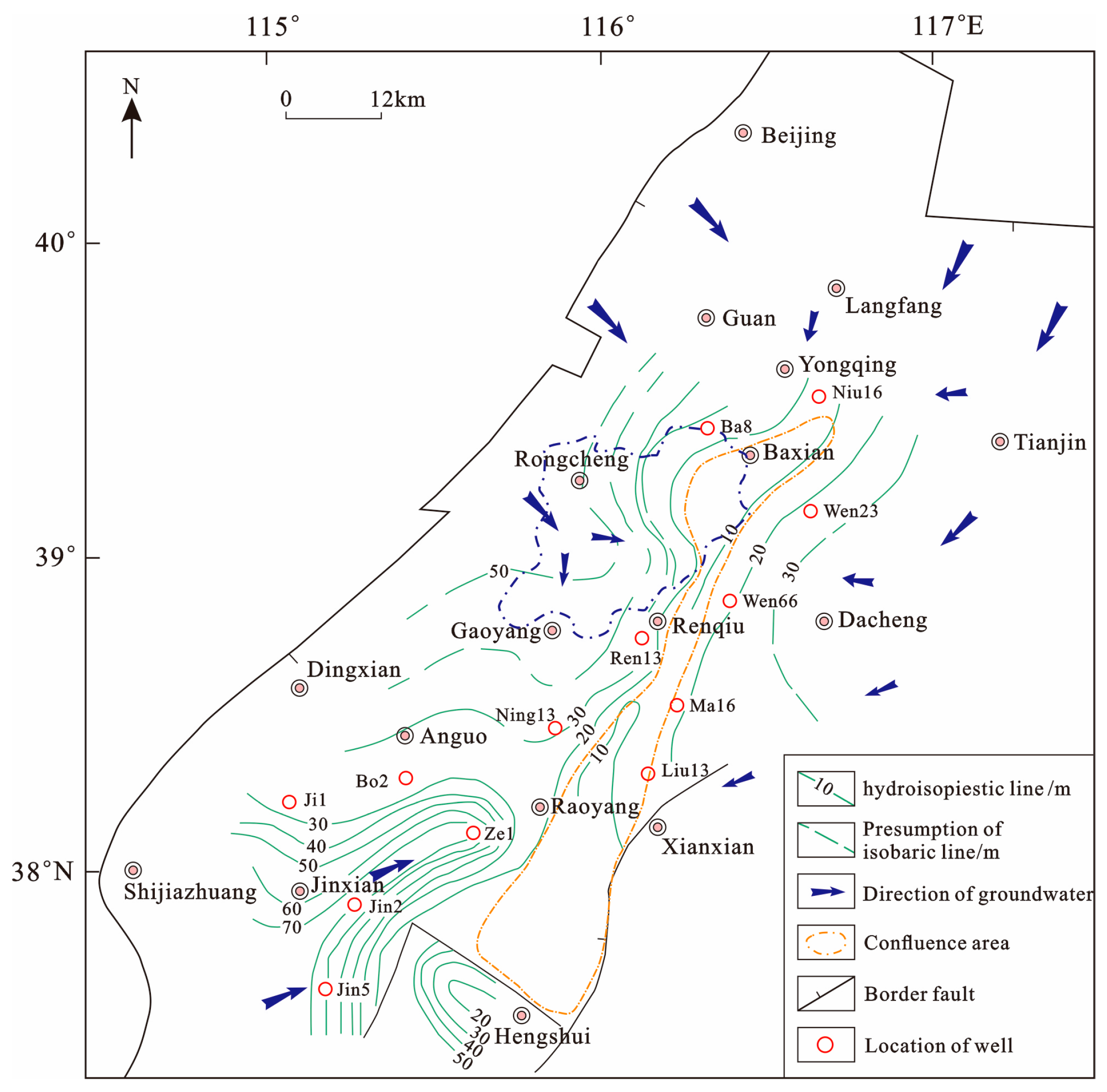
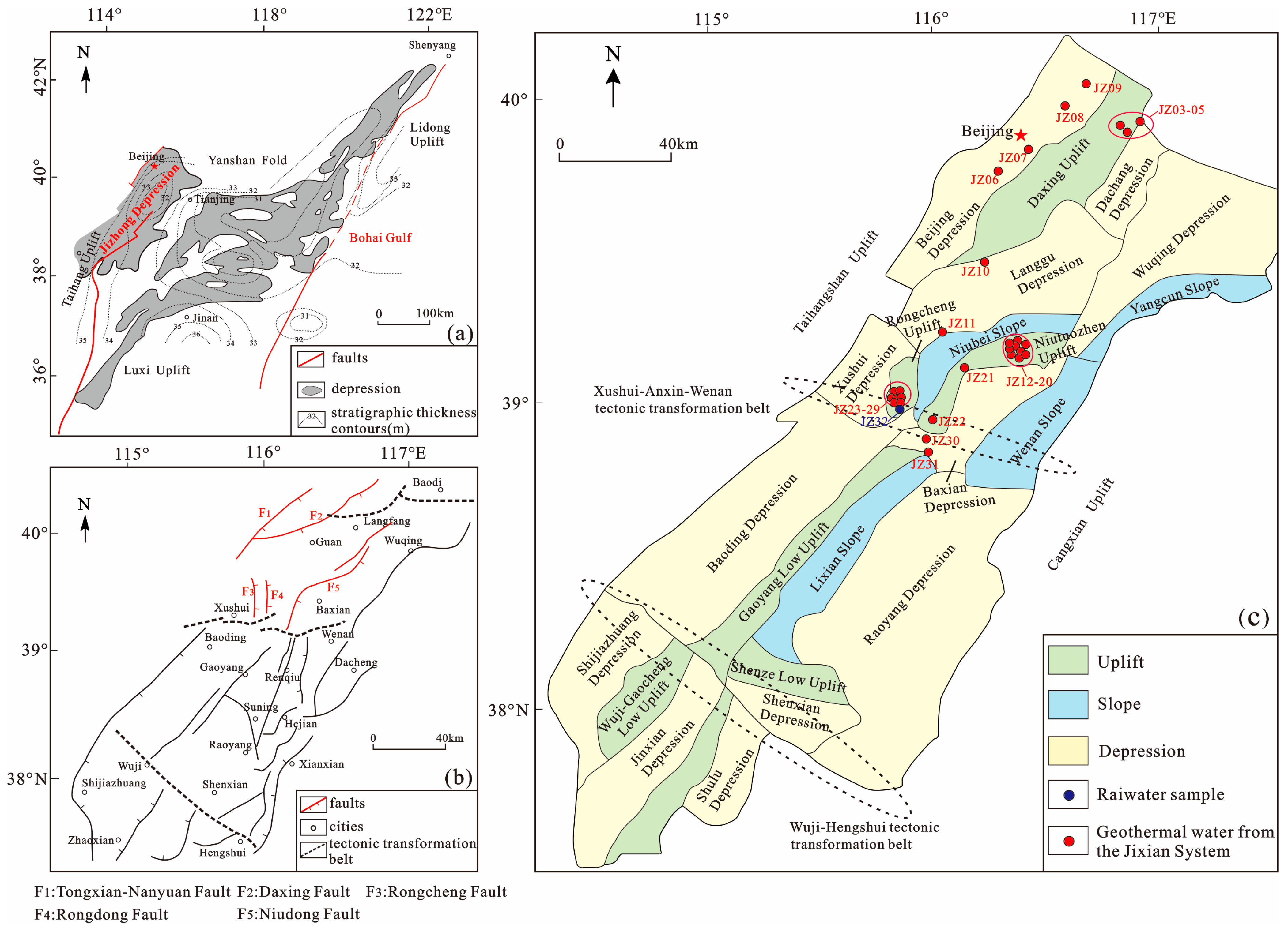
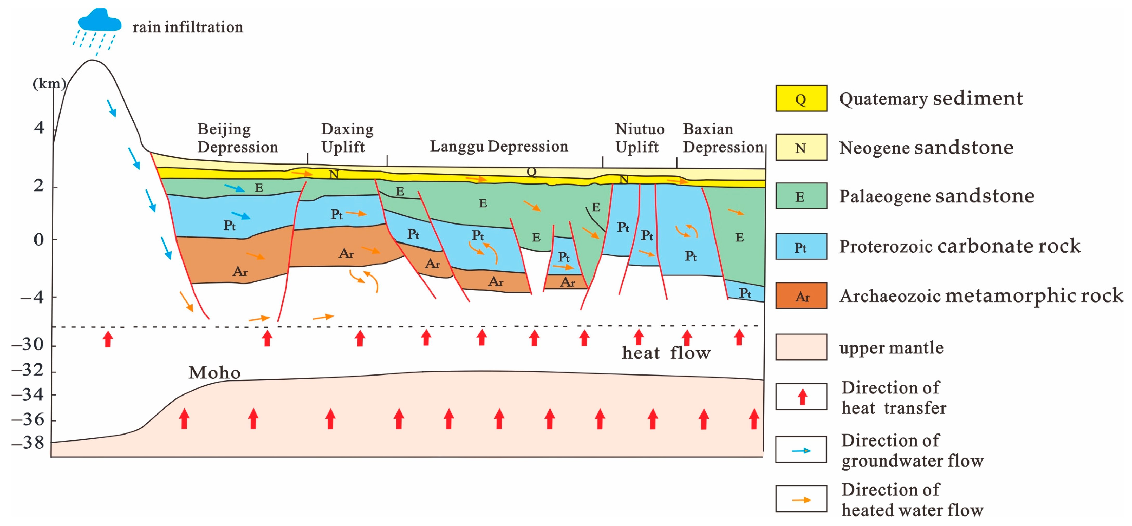
2. Geological Setting

The Jizhong Depression, situated in the northwest of the Bohai Bay Basin, is bordered by the Yanshan Uplift to the north, the Xingheng Uplift to the south, the Taihangshan Uplift to the west, and the Cangxian Uplift to the east, stretching in a northeast orientation [23] (Figure 1a). Regionally, the Jizhong Depression has undergone multiple tectonic phases, resulting in a concave–convex structural pattern. It is segmented into southern, central, and northern zones by two transform zones: the nearly WE Wuji-Hengshui zone and the NWW Xushui-Anxin-Wenan zone [24]. This study focuses on the northern Jizhong Depression, encompassing six fourth-order tectonic units, namely the Beijing, Dachang, and Langgu depressions, as well as the Daxing, Niutuozhen, and Rongcheng uplifts. Faults are distributed in the study area, exhibiting an NE trend overall and predominantly including extensional faults such as the Taihang Mountains piedmont, Tongxian-Nanyuan, Daxing, Rongcheng, Rongdong, and Niudong faults from the northwest to southeast (Figure 1b). These faults significantly influence the distribution of regional secondary tectonic units. The Daxing fault, with its varied orientation, exhibits distinct geological and tectonic characteristics in different segments [25]. Specifically, its northern segment has an NNE strike and is connected to the boundary fault that dictates the Dachang Depression to the north; its middle segment has a NE strike, governing the boundary between the Daxing Uplift and the Langgu Depression; and its southern segment has varied orientations, reflecting the variability of the fault activity. The Rongcheng fault, which extends to the crystalline basement, is a growth fault influencing the development of Neoproterozoic strata [26]. The Rongdong fault with a strike of NNE delineates the boundary between the Niutuozhen and Rongcheng uplifts. The Niudong fault impacts both the Niutuozhen Uplift and the Baxian Depression, serving as a deep-seated, long-term active fault penetrating the crystalline basement [27]. Collectively, these faults shape the regional tectonic framework and play pivotal roles in geothermal resource formation by acting as thermal and water conduits. Additionally, predominant deposits in the study area comprise Archean metamorphic rock, Upper-Middle Proterozoic carbonate rock, Ordovician–Cambrian, Neogene sandstone, and Quaternary sediment from bottom to top [28]. The Cenozoic cover primarily consists of sandstone, mudstone, and sandy mudstone. The primary geothermal reservoirs are mainly carbonate rocks, with the top interface influenced by regional basement tectonics and the lithology characterized by gray dolomite and muddy dolomite [23]. The rock fissures, due to their advanced development and superior thermal properties, underscore the Jizhong Depression’s geothermal resource potential.

3. Material and Methods

In this study, 25 groups of water samples and an additional 7 groups were collected, totaling 32 groups. The distribution of samples across tectonic units is as follows: three from the Daxing Uplift, four from the Beijing Depression, two from the Langgu Depression, eleven from the Niutuozhen Uplift, seven from the Rongcheng Uplift, two from the Gaoyang Low Uplift, one from local rainfall, and two from the Taihang Mountains’ mountainous areas (Figure 1c). During field sample collection from geothermal wells, the geographic locations, coordinates, and geological structures of the sample sites were recorded. Furthermore, the water temperature at wellhead was gauged using an infrared geothermometer, while pH, oxidation–reduction potential (ORP), and TDS were measured using a multi-parameter water quality analyzer. The water samples were collected into thrice-cleaned 500 mL volumetric flasks, sealed for preservation, and then dispatched to the Key Laboratory of Groundwater Science and Engineering, Ministry of Land and Resources for comprehensive hydrochemical analysis. Cation concentrations in the samples were detected via the ICP-AES (Inductively Coupled Plasma Atomic Emission Spectrometry) method, while anions were assessed using the ion chromatography method (Dionex-500), ensuring an accuracy of 0.02 mg/L for both anions and cations and an equilibrium error below 5%. SiO2 (dissolved) was gauged via spectrophotometry. The δ2H and δ18O values were determined as per the DZ/T 0184.19-1997 standard [30], using a water isotope analyzer (Picarro2140-i), with detection accuracies of 0.1 and 0.3, respectively, and the analytical error was maintained at ±0.5%. The chemical composition results of hot water samples from the underground carbonate geothermal reservoirs in the study area are detailed in Table 1.

4. Results and Discussion
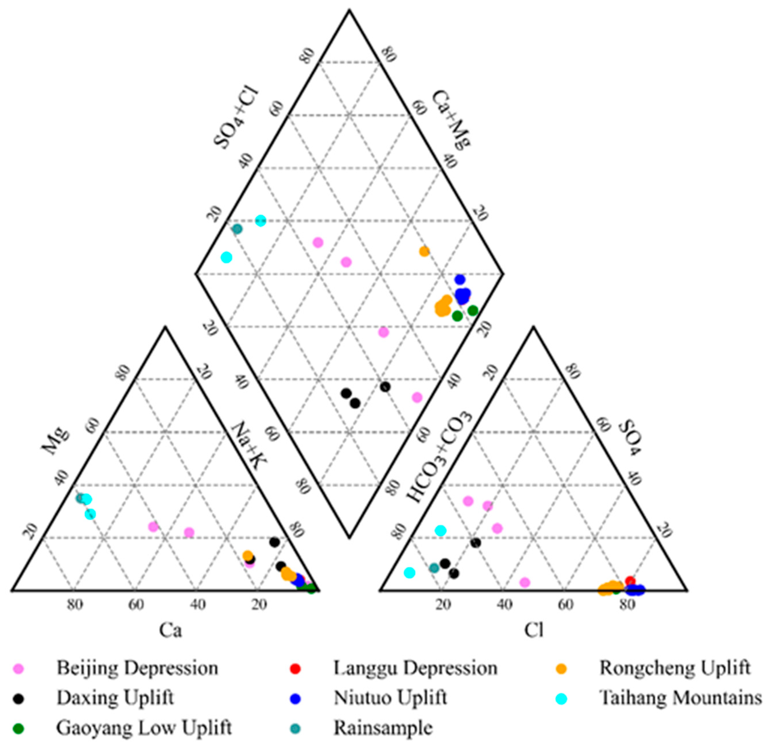
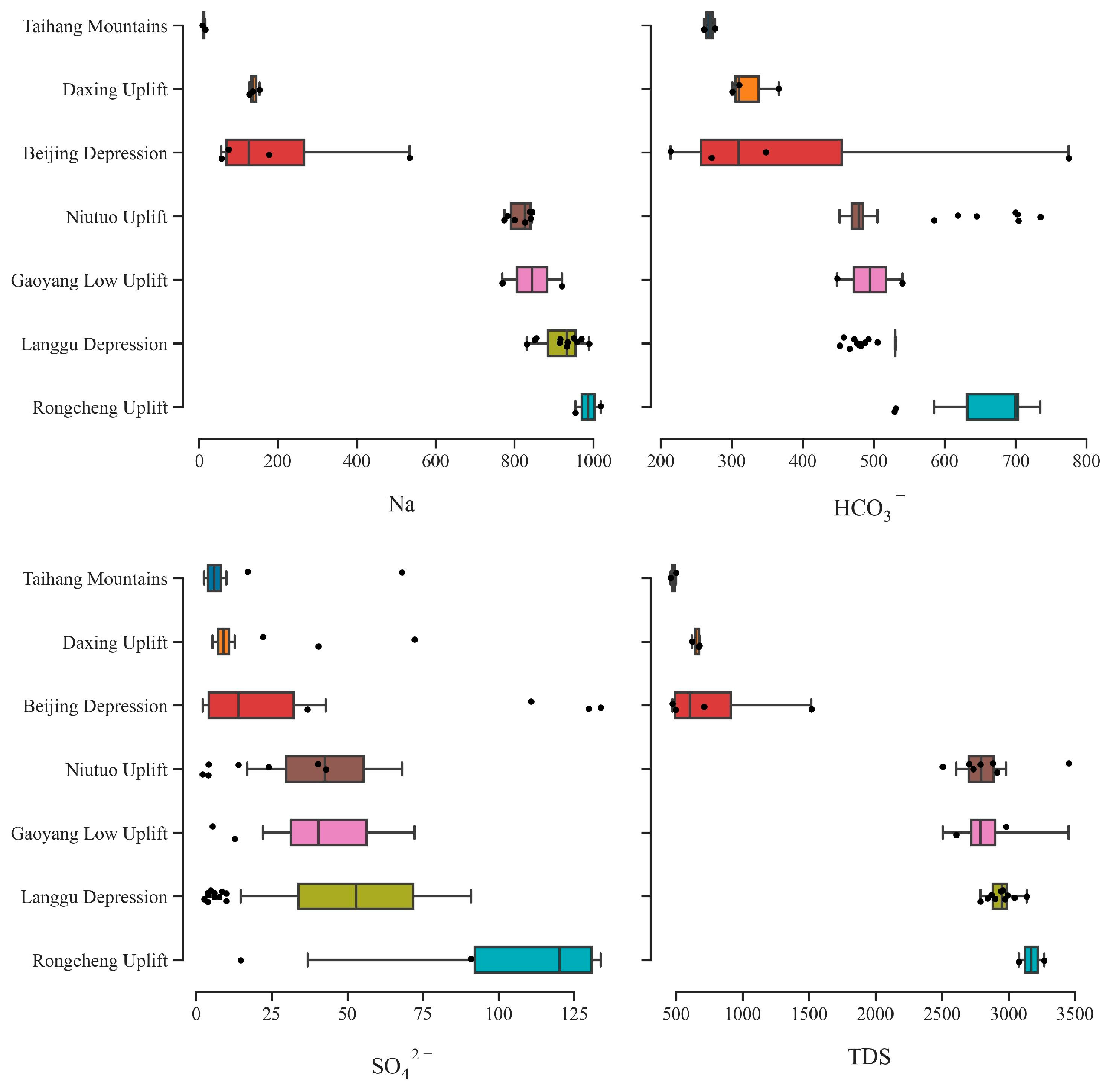
4.1. Hydrochemistry

The Aquachem software (V 4.0 ) [32] was utilized to plot Piper trilinear diagrams for the water sample locations (Figure 2). Based on these diagrams and the hydrochemical test results (Table 1) [33,34], it can be determined that the spring water in the zone with exposed carbonate rocks in the Taihang Mountains’ mountainous area has an average temperature of 14 °C, a pH of 7.69–7.92, a TDS between 458 and 501.9 mg/L, and a hydrochemical type of HCO3-Ca·Mg. Carbonate reservoirs primarily comprise thickly laminated dolomite, with carbonate minerals such as calcite and dolomite serving as the primary sources of Ca2+, Mg2+, and HCO3 [35]. A total of 29 geothermal water samples from the study area’s carbonate reservoirs were mostly weakly alkaline, with a pH ranging from 6.61 to 8.87, with an average of 7.7. The hot water samples collected at the wellhead exhibited temperatures spanning from 33.9 to 123.4 °C, a TDS from 473.9 to 3452 mg/L, and a dissolved SiO2 content ranging from 20.08 to 150.31 mg/L. The samples from both the Daxing Uplift and the Beijing Depression displayed diverse hydrochemical types, predominantly comprising Na·Mg-HCO3, Ca·Na·Mg-HCO3·SO4, Na·Ca·Mg-HCO3·SO4, and Na-HCO3·Cl·SO4. In contrast, the water samples from the Langgu Depression, Niutuozhen Uplift, Rongcheng Uplift, and Gaoyang Low Uplift primarily showed two hydrochemical types: Na-Cl and Na-Cl-HCO3.
Comparing the water sample data from the Taihang Mountains, Daxing Uplift, Beijing Depression, Langgu Depression, Niutuozhen Uplift, Rongcheng Uplift, and Gaoyang Low Uplift, there is a sequential increase in the groundwater TDS from the recharge zone to the runoff zone and then to the discharge zone. Accordingly, the hydrochemical type changes, with the Na+ cation becoming gradually predominant. Water–rock interactions cause Mg2+ and Ca2+ in the geothermal water to replace Na+ in the surrounding minerals and then be adsorbed by the reservoir rock. The HCO3 and Cl contents increase progressively (Figure 3). Among them, HCO3 originates from the dissolution and filtration of carbonate minerals, while Cl exhibits significant migration and solubility [20]. The decreasing SO42− content from the recharge to discharge areas suggests the gradual closing of the geothermal water space and a shift from an oxidizing to a reducing environment, with desulfurization leading to H2S production (Figure 4).
In the study area, the Li+ concentrations in the water samples ranged from 0.151 to 1.97 mg/L. As per GB8537-2018 [36], all water samples met the criteria for lithium mineral water, except for the JZ06 and 07 samples. The Sr2+ concentration in the samples spanned from 0.296 to 2.692 mg/L, fulfilling the criteria for strontium mineral water. The F concentrations varied between 4.65 and 19.22 mg/L. The high fluoride concentration in the underground hot water is primarily ascribed to the weakly alkaline environment, water temperature, and water–rock interactions.
Figure 4. Contour map of the phreatic pressure level elevation in the Jizhong Depression [37].
Water 15 03881 g004

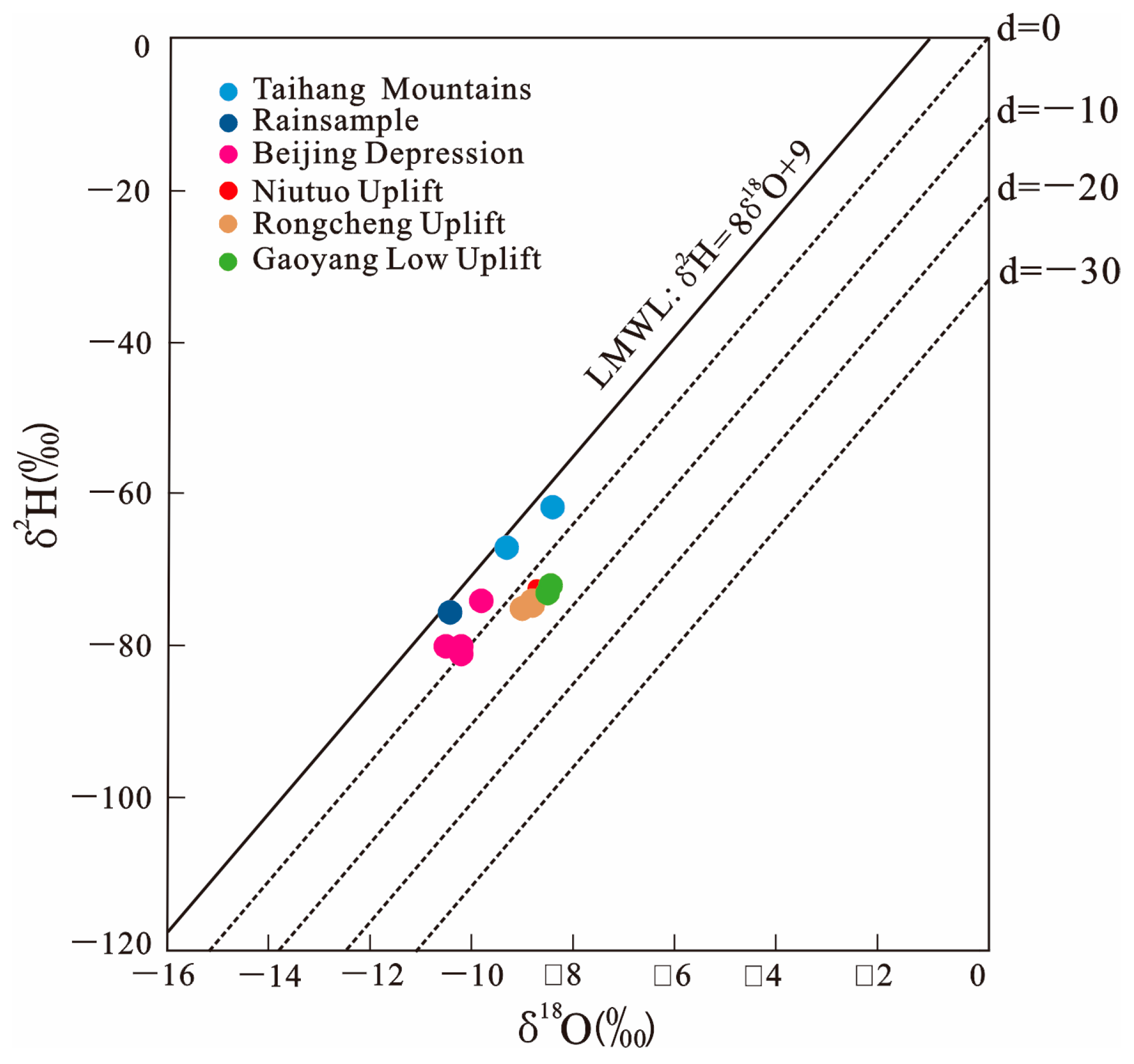
4.2. Isotopic Composition of Water

Studying the isotope characteristics of groundwater hydroxides allows for the determination of the groundwater origins [21] and the understanding of groundwater circulation pathways based on the varied distributions of the hydroxide isotope data in the diagram (Figure 5) showing the δ2H-δ18O relationships. In this research, the local meteoric water line (LMWL) [26] was used to plot the δ2H and δ18O values of the water samples (Table 2) on the relationship diagram. The hydroxide isotope data of the water samples from the study area roughly fell on one side of the GMWL. A strong correlation between the δ2H and δ18O values indicates that the geothermal water in the study area’s paleo-submerged geothermal reservoirs is recharged by atmospheric precipitation infiltrating them (Figure 5). When compared to the Taihang Mountains and the Beijing Depression, the hydrogen and oxygen isotope data from the Niutuozhen Uplift and Rongcheng Uplift deviate more significantly from the GMWL, displaying a pronounced oxygen drift. This suggests a progressively enclosed environment and increasingly deep carbonate geothermal reservoirs from the recharge to discharge areas. Furthermore, there exist intense isotope exchanges in the regions with elevated temperatures.

4.3. Geothermal Reservoir Temperature Estimation

The geothermal reservoir temperature is crucial for understanding the geothermal activity. This temperature serves as a fundamental basis for categorizing the genetic type of geothermal resources, assessing resource potential, and choosing the appropriate exploitation and utilization approach [38]. In the absence of boreholes or when boreholes fail to reach the geothermal reservoirs, geothermometry offers an avenue to estimate the temperature of deep geothermal reservoirs [39]. The current prevalent geothermometers encompass both the cationic geothermometers and the SiO2 geothermometers. Additionally, the multi-mineral equilibrium diagram, along with the silicon–enthalpy equation method that considers cold water mixing, can address the shortcomings of geothermometers [40]. As such, they are also widely applied to the estimation of the geothermal reservoir temperature.

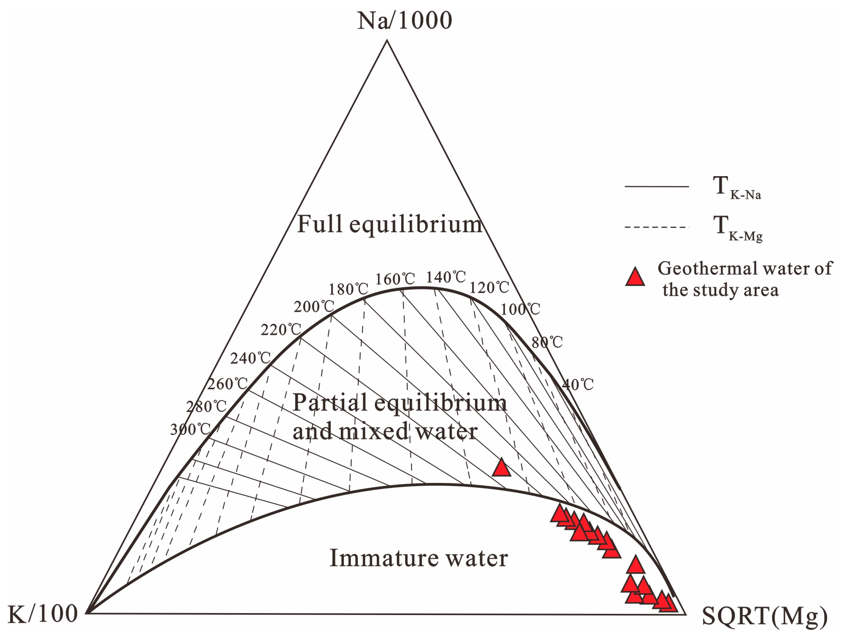
4.3.1. Combination of Empirical Chemical Geothermometers

Utilizing geothermometers to estimate the temperatures of a geothermal system of low- to medium-temperature carbonate geothermal reservoirs poses multiple challenges [41]. Among these are the underestimation of geothermal reservoir temperatures, the difficulties in reaching the equilibrium of hydrothermal alteration minerals in geothermal fluids, and the limitations associated with controlling hydrochemical component minerals [42]. In the current study, a range of geothermometers were first employed to predict the deep geothermal reservoir temperature in the study area (Table 3). Notably, the derived values of geothermal reservoir temperatures using these diverse methods displayed substantial variations, necessitating a comprehensive examination of the applicability of each method.
The commonly used cationic geothermometers include Na-K, Na-K-Ca, and K-Mg geothermometers [43,44,45,46,47]. Typically, when these cationic geothermometers are used to estimate the temperatures of deep thermal reservoirs, the Na-K-Mg triangular diagram proposed by Giggenbach (1988) [47] is frequently adopted to determine whether the geothermal fluids have reached an equilibrium state in the water–rock interactions. As illustrated in Figure 6, the water sampling points predominantly fall within the zone of immature water. This finding illuminates that the deep reservoir temperature inferred using the Na-K thermometer, which works based on the K+-to-Na+-concentration ratio in the geothermal fluid, was markedly elevated compared to the temperature determined through direct measurements. The K+-to-Na+-concentration ratio is heavily dependent on the ion exchange reactions transpiring between potassium and sodium feldspars [42]. Although the Na-K geothermometer is more applicable to the estimation of temperatures of high-temperature reservoirs, specifically those above 200 °C, it encounters challenges in achieving ion-exchange equilibrium between potassium and sodium feldspars when used to estimate temperatures of moderate- and low-temperature geothermal reservoirs (below 200 °C) [48]. This finding accounts for the pronounced deviation from the equilibrium line that is observed for a plethora of sample points from moderate- and low-temperature geothermal reservoirs. While K-Mg equilibrium is relatively easier to achieve [47], the influence of mixing could potentially skew the K-Mg geothermometer outcomes, with the computational accuracy yet to be accurately evaluated. Furthermore, the Na-K-Ca geothermometer, proposed by Fournier and Truesdell (1973) [45], originates from empirical data. Yet, when employed in the study area, its predictions were typically lower than the observed water temperatures. Collectively, these observations insinuate that utilizing cationic geothermometers to predict the temperatures of geothermal fluids in deep carbonate geothermal reservoirs in the study area might not be the most pragmatic approach.
SiO2 geothermometers are constructed upon the solubility characteristics of SiO2 minerals. Remarkably, SiO2 dissolved in water is relatively immune to the vagaries of ionic interactions, the evapotranspiration of other complexes, and dilution. The solubility of SiO2 and other minerals increases with the temperature and, inversely, their precipitation accelerates when the temperature declines; therefore, different mineral contents mirror respective geothermal fluid temperatures [21]. Among the SiO2 geothermometers that are commonly used today include quartz and chalcedony geothermometers. The analysis in this study (Table 4) suggests that the chalcedony geothermometer predictions are more aligned with the directly measured water temperatures at the wellhead. Furthermore, the research underpins the notion that in a geothermal system with a temperature below 180 °C, chalcedony, rather than quartz, is predominantly responsible for overseeing the dissolution kinetics of SiO2 in the geothermal medium [49]. In culmination, the chalcedony geothermometer is more applicable to the study area than the quartz geothermometer, projecting the temperatures of carbonate geothermal reservoirs in the study area to range between 63 and 137.6 °C.

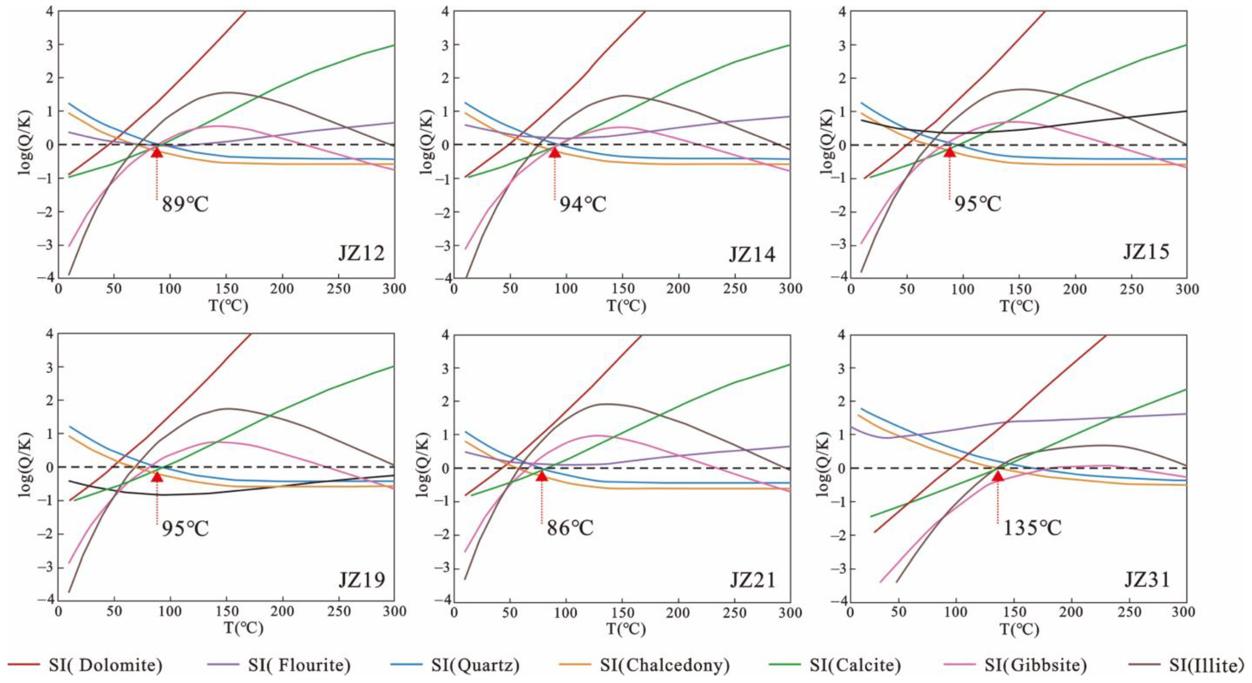
4.3.2. Modeling of Multi-Mineral Saturation States

The multi-mineral equilibrium method used for geothermal systems represents a reservoir temperature calculation technique grounded on the simulation of multi-component chemical equilibrium in a geothermal system [50,51,52,53,54]. This method works on the principle that saturation indices (SIs) (SI = log(Q/K)) for an array of minerals synchronously converge to SI = 0 at a specific temperature [55]. Therein, Q denotes the ion activity product of the water sample, and K denotes the equilibrium constant (Reed) [53]. This temperature is identified as the fluid–mineral equilibrium temperature, which corresponds to the estimated reservoir temperature of a geothermal system [50].
In this study, the saturation indices of seven distinct minerals, namely dolomite, fluorite, quartz, chalcedony, calcite, gibbsite, and illite, at varying temperatures, were computed using the Phreeqc software (V 3.6) [56]. Subsequently, the log(Q/K) vs. T equilibrium diagrams for the water samples from the study area were constructed. The temperature intervals at which the curves of multiple minerals converge on the straight line with the vertical coordinate, log(Q/K) = 0, denote the temperatures of deep geothermal reservoirs.
An inspection of Figure 7 reveals that merely a minor segment of the mineral SI curves aligns with the straight line with the vertical coordinate, log(Q/K) = 0. The convergence temperature intervals appear rather dispersed, a phenomenon that is potentially attributed to the influence of cold water mixing occurring as the geothermal water ascends to the surface. Underground hot water undergoes modifications due to processes like precipitation, dissolution, and mixing during its ascent. Such alterations can result in an unbalanced appearance in the mineral SI curves [57]. Within this data set, the equilibrium diagrams for quartz, chalcedony, and calcite exhibited a more pronounced intersection with the straight line corresponding to the horizontal coordinate, log(Q/K) = 0. The reservoir temperature intervals determined by these intersections closely approach equilibrium. Furthermore, the Phreeqc software offers a limited temperature estimation range. Based on the findings presented in Figure 7 (these curves are optimized to fit the mineral data for each location), the reservoir temperature in the study area ranges between 80 and 140 °C.

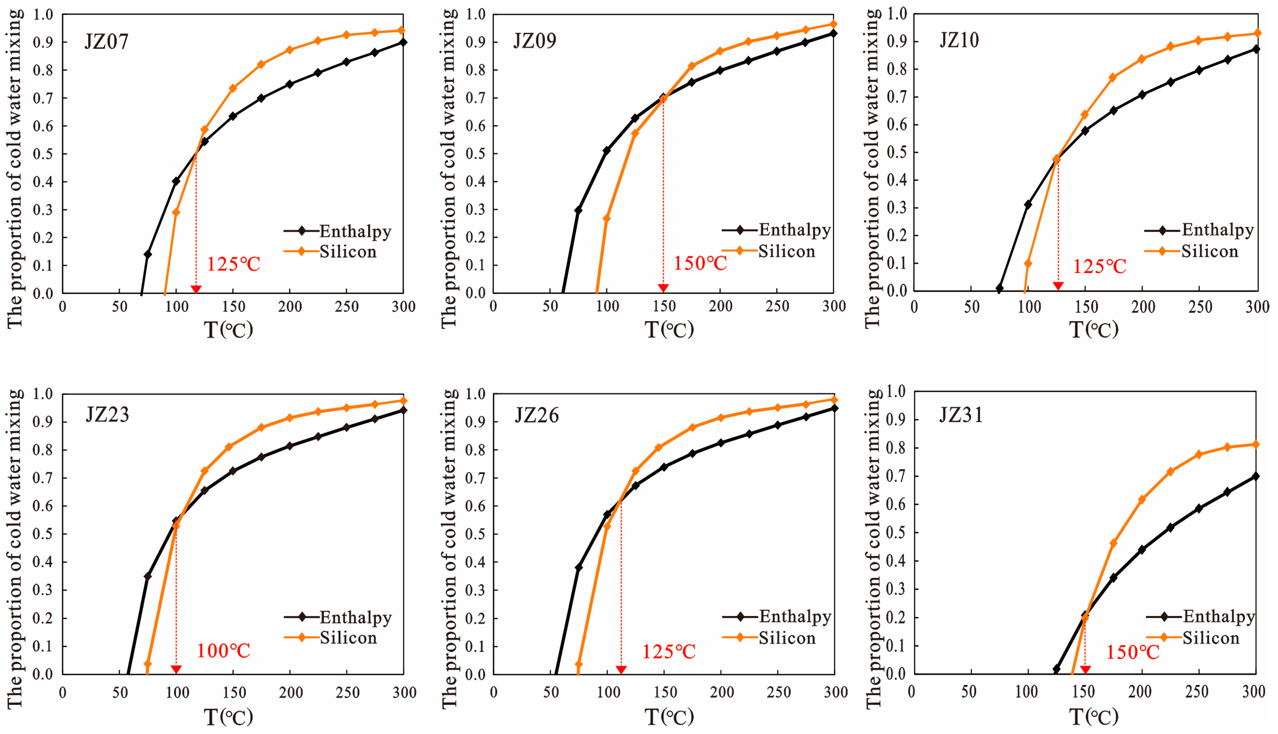
4.3.3. Silica–Enthalpy Mixing Models

Fault development in the study area provides favorable runoff conditions, with the potential mixing of deep fluids with the near-surface cold water in the stage of geothermal water circulation. This study employed the silicon–enthalpy equation method [56,58,59] to analyze the hot water mixing conditions, constructing two distinct equations for the initial enthalpy of deep hot water [60]:
ScX1 + Sh(1 − X1) = Ss
SiO2cX2 + SiO2h(1 − X2) = SiO2s
where Sc is the enthalpy of the near-surface cold water, set at the local average annual temperature of 17.5 °C [20]; Sh denotes the initial enthalpy of the deep hot water; Ss is the final enthalpy of the hot water; SiO2c represents the SiO2 concentration in the near-surface cold water, established as 17.15 mg/L [20]; SiO2s is the SiO2 concentration in the deep hot water; and SiO2h is the initial SiO2 concentration in the deep hot water, and it is a function of Sh. X1 is the proportion of mixed surface cold water with respect to enthalpy formation; X2 is the proportion of mixed surface cold water with respect to SiO2 content formation.
Substituting the specific enthalpies and the SiO2 contents of underground hot water (Table 5) at designated temperatures in the study area into the equations yielded a series of X1 and X2 values (Table 6). Furthermore, the relationship between the hot water temperature and the cold water mixing ratio was plotted (Figure 8). The temperatures at the points of intersection between the X1 and X2 curves represent the highest reservoir temperatures before geothermal fluid mixing with cold water, as determined using the silicon–enthalpy equation method. As illustrated in Figure 8, the reservoir temperatures estimated using the silica–enthalpy equation method ranges from 100 °C to 150 °C.
This study estimated the deep reservoir temperature in the study area using the classical geothermometers, multi-mineral SI simulation, and the silicon–enthalpy equation method. The Si-enthalpy equation method operates under the ideal condition that no heat loss occurs in underground hot water prior to cold water mixing and takes into account the influence of cold water mixing on temperature reduction. However, the actual environment of deep geothermal reservoirs is more complex, and it is virtually impossible to achieve the ideal state. Furthermore, SiO2 minerals, such as quartz, calcite, opal, and so on, are pervasive in natural rocks, and water-soluble SiO2 is immune to common ionic effects, complex formation, and volatilization. Based on a thorough comparison of wellhead temperatures, geothermometers (Table 4), multiple mineral equilibrium diagrams, and the silicon–enthalpy equation method, it can be determined that the chalcedony geothermometer, which suggested deep reservoir temperatures ranging between 63 and 137.6 °C (Table 4), offered the most accurate estimation.

4.4. Circulation Depth

The Jizhong Depression, situated in the North China Plain, represents a sedimentary basin type of geothermal resources. In this region, the temperature of the underground hot water shows a positive correlation with the depth of thermal circulation. The following equation can be employed to approximate the depth of hot water circulation [61]:
H = t 1 t 2 I + h
where H is the depth of hot water circulation; t1 is the reservoir temperature (°C); t2 is the multi-year average air temperature (°C); I is the geothermal gradient (°C/100 m); and h is the depth of the constant temperature zone (m). For the study area, the reservoir temperature was estimated from the results derived using a chalcedony geothermometer. Furthermore, the annual average temperature was set at 17.5 °C, the geothermal gradient was chosen as 3.5 °C/100 m [24], and the constant temperature zone depth was based on the regional value of 25 m [60]. Using these parameters, the thermal circulation depth for the deep geothermal reservoirs in the study area was estimated to range between 1324 m and 3455 m (Table 7).

5. Conceptual Genetic Model

The destruction of the North China Craton led to the thinned lithosphere and pronounced tectonic and thermal activity, facilitating the upward heat conduction from deeper sections. Carbonate rocks, possessing high thermal conductivity, refract this heat. Furthermore, heat flow migrates from depression zones with a low thermal conductivity to elevated areas with higher conductivity. By combining these mechanisms with favorable conditions, geothermal reservoirs that are abundant in deep geothermal resources are formed within the carbonate rock strata characterized by extensive karst fissures [62,63,64]. Based on the geochemical characteristics of thermal fluids in the geothermal reservoirs of ancient buried hills in the northern Jizhong Depression, as well as the geothermal geological conditions in the study area, this study established a conceptual model for the deep karst geothermal system; atmospheric precipitation in mountainous areas permeates through faults, journeying deep due to gravity. Over prolonged recharge via lateral runoff, this water enters the interior of the depression, fully absorbing significant heat from deeper sources. As a result, deep geothermal reservoirs form in the northern Jizhong Depression. Concurrently, regional tectonic faults offer optimal pathways for the transfer of deep water and heat sources. Furthermore, the deep groundwater circulation promotes the formation of geothermal anomalies (Figure 9).

6. Conclusions

The following conclusions can be drawn:
(1) Underground hot water samples from the deep carbonate geothermal reservoirs in the study area generally exhibit weak alkalinity. The total dissolved solids (TDS) in underground water increase progressively from the recharge area to the runoff area and finally to the discharge area. Concurrently, the hydrochemistry transitions from an oxidizing environment to a reducing environment. The primary recharge source for deep geothermal reservoirs is atmospheric precipitation in mountainous areas. As the depth of carbonate geothermal reservoirs increases, the environment becomes increasingly isolated, with intensified water–rock interactions and pronounced isotope exchange in warmer zones.
(2) The most suitable geothermometer for deep karst geothermal reservoirs in the study area is the chalcedony geothermometer. The estimated deep reservoir temperature ranges between 63 °C and 137.6 °C.
(3) Atmospheric precipitation in mountainous areas permeates through piedmont faults, journeying deep due to gravity. Regional tectonic faults provide favorable channels for the transfer of deep water and heat sources. Furthermore, deep groundwater circulation promotes the formation of geothermal anomalies.

Author Contributions

Conceptualization, M.Y. and X.T.; methodology, M.Y.; software, M.Y.; validation, M.Y., X.T. and H.Z.; formal analysis, M.Y.; investigation, M.Y., Z.Z., H.L. and X.Y.; resources, M.Y., X.T. and H.Z.; data curation, M.Y.; writing—original draft preparation, M.Y.; writing—review and editing, M.Y., X.T., H.Z., J.L., L.W., Z.Z., H.L. and X.Y.; visualization, X.Y.; supervision, H.Z.; project administration, X.T. and H.Z.; funding acquisition, X.T. and H.Z. All authors have read and agreed to the published version of the manuscript.

Funding

This research and APC were funded by the characteristics of geological environment endowment and the formation and evolution mechanism of environmental geological problems (grant number 225A4204D) and Comprehensive Evaluation and Layout Optimization of Bedrock Thermal Reserves in Hebei Plain (grant number 13000023P00329410174Y).

Data Availability Statement

All data analyzed in this study are available from the corre- sponding authors upon reasonable request.

Conflicts of Interest

Author Xinlong Yang was employed by the company Beijing Huaqing Geothermal Development Group Co., Ltd. The remaining authors declare that the research was conducted in the absence of any commercial or financial relationships that could be construed as a potential conflict of interest.

References

  1. Tester, J.W.; Anderson, B.J.; Batchelor, A.S.; Blackwell, D.D.; Dipippo, R.; Drake, E.M. The Future of Geothermal Energy. Mass. Inst. Technol. 2006, 358, 1–3. [Google Scholar]
  2. Hillis, R.R.; Hand, M.; Mildren, S.D.; Reid, P.D.; Reynolds, S.D.; Nelson, E.J. Hot Dry Rock Geothermal Exploration in Australia. ASEG Ext. Abstr. 2004, 1, 1–4. [Google Scholar] [CrossRef]
  3. Wang, G.L.; Lin, W.J.; Zhang, W.; Lu, C.; Ma, F.; Gan, H.N. Research on Formation Mechanisms of Hot Dry Rock Resources in China. Acta Geol. Sin. 2016, 90, 1418–1433. [Google Scholar]
  4. Liu, F.; Zhang, W.; Wang, G.L.; Wei, S.C.; Yue, C.; Jiang, G.Z.; Liao, Y.Z. Geothermal anomalies in the Xianshuihe area: Implications for tunnel construction along the Sichuan-Tibet Railway, China. J. Groundw. Sci. Eng. 2023, 11, 237–248. [Google Scholar] [CrossRef]
  5. Shi, H.L.; Wang, G.L.; Lu, C. Numerical investigation on delaying thermal breakthrough by regulating reinjection fluid path in multi-aquifer geothermal system. Appl. Therm. Eng. 2022, 221, 119692. [Google Scholar] [CrossRef]
  6. Lin, W.J.; Wang, G.; Gan, H.N.; Zhang, S.S.; Zhao, Z.; Yue, G.F.; Ting, L.X. Heat source model for Enhanced Geothermal Systems (EGS) under different geological conditions in China. Gondwana Res. 2023, 122, 243–259. [Google Scholar] [CrossRef]
  7. Wang, G.L.; Lin, W.J. Main hydro-geothermal systems and their genetic models in China. Acta Geol. 2020, 94, 1923–1937. (In Chinese) [Google Scholar]
  8. Ma, F.; Wang, G.L.; Zhang, W.; Zhu, X.; Zhang, H.X.; Yue, G.F. Structure of geothermal reservoirs and resource potential in the Rongcheng geothermal field in Xiong’an New Area. Acta Geol. Sin. 2020, 94, 1981–1990. (In Chinese) [Google Scholar]
  9. Wang, G.L.; Zhang, W.; Liang, J.Y.; Lin, W.J.; Liu, Z.M.; Wang, W.L. Evaluation of Geothermal Resources Potential in China. Acta Geosci. Sin. 2017, 38, 12. (In Chinese) [Google Scholar]
  10. Li, M.; Xing, L.X.; Wang, G.L.; Zhang, W.; Zhao, J.Y.; Jin, M.G. Distribution characteristics of fluorine in deep geothermal water in Jizhong Depression and its risk assessment and suggestions for utilization. Geol. China 2023. (In Chinese) [Google Scholar]
  11. Eberhard, L.; Pettke, T. Antigorite dehydration fluids boost carbonate mobilisation and crustal CO2 outgassing in collisional orogens. Geochim. Cosmochim. Acta 2021, 300, 192–214. [Google Scholar] [CrossRef]
  12. Weydt, L.M.; Heldmann, C.D.J.; Machel, H.G.; Sass, I. From oil field to geothermal reservoir: Assessment for geothermal utilization of two regionally extensive Devonian carbonate aquifers in Alberta, Canada. Solid Earth 2018, 9, 953–983. [Google Scholar] [CrossRef]
  13. Hoefs, J. Stable Isotope Geochemistry/Jochen Hoefs; Springer: Berlin/Heidelberg, Germany, 2009. [Google Scholar]
  14. Chimeddorj, B.; Munkhbat, D.; Altanbaatar, B.; Dolgorjav, O.; Oyuntsetseg, B. Hydrogeochemical characteristics and geothermometry of hot springs in the Altai region, Mongolia. Geochem. Explor. Environ. Anal. 2021, 21, 4. [Google Scholar] [CrossRef]
  15. Stober, I.; Bucher, K. Geothermal Energy: From Theoretical Models to Exploration and Development; Springer Nature: Basel, Switzerland, 2021. [Google Scholar]
  16. Yurteri, C.; Simsek, S. Hydrogeological and hydrochemical studies of the Kaman-Savcili-Büyükoba (Kirsehir) geothermal area, Turkey. Geothermics 2017, 65, 99–112. [Google Scholar] [CrossRef]
  17. Soldatova, E.A.; Guseva, N.V.; Sun, Z.; Mazurova, I.S. Size fractionation of trace elements in the surface water and groundwater of the Ganjiang River and Xiushui River basins, China. IOP Conf. Ser. Earth Environ. Sci. 2015, 27, 012037. [Google Scholar] [CrossRef]
  18. Han, D.M.; Currell, M.J. Delineating multiple salinization processes in a coastal plain aquifer, northern China: Hydrochemical and isotopic evidence. Hydrol. Earth Syst. Sci. 2018, 22, 3473–3491. [Google Scholar] [CrossRef]
  19. Pang, J.M.; Pang, Z.H.; Lv, M.; Tian, J.; Kong, Y.L. Geochemical and isotopic characteristics of fluids in the Niutuozhen geothermal field, North China. Environ. Earth Sci. 2018, 77, 12. [Google Scholar] [CrossRef]
  20. Zhu, X.; Wang, G.L.; Wang, X.Y.; Qi, S.H.; Ma, F.; Zhang, W.; Zhang, H.X. Hydrogeochemical and Isotopic Analyses of Deep Geothermal Fluids in the Wumishan Formation in Xiong’an New Area, China. Lithosphere 2022, 2022, 2576752. [Google Scholar] [CrossRef]
  21. Yu, M.X.; Wang, G.L.; Ma, F.; Zhang, W.; Lin, W.J.; Zhu, X.; Zhang, H.X. Geochemical characteristics of geothermal fluids of a deep ancient buried hill in the Xiong’an New Area of China. Water 2022, 14, 3182. [Google Scholar] [CrossRef]
  22. Wang, Y.J.; Ma, F.; Xie, H.P.; Wang, G.L.; Wang, Z.H. Fracture Characteristics and Heat Accumulation of Jixianian Carbonate Reservoirs in the Rongcheng Geothermal Field, Xiong’an New Area. Acta Geol. Sin. Engl. Ed. 2021, 95, 1902–1914. [Google Scholar] [CrossRef]
  23. He, D.F.; Cui, Y.Q.; Shan, S.Q.; Xiao, Y.; Zhang, Y.Y.; Zhang, C.B. Characteristics of geologic framework of buried-hill in Jizhong depression, Bohai Bay Basin. Chin. J. Geol. 2018, 53, 1–24. (In Chinese) [Google Scholar]
  24. Chang, J.; Qiu, N.S.; Zhao, X.Z.; Xu, W.; Xu, Q.C.; Jin, F.M.; Han, C.Y.; Ma, X.F.; Dong, X.Y. Present-day geothermal regime of the Jizhong depression in Bohai Bay basin, East China. Chin. J. Geophys. 2016, 59, 1003–1016. (In Chinese) [Google Scholar]
  25. Zhao, H.G.; Liu, C.Y. Research on the Segmentation of Daxing Fault. Oil Cas Geol. 2002, 23, 368–371. (In Chinese) [Google Scholar]
  26. Zhao, J.Y.; Zhang, W.; Ma, F.; Zhu, X.; Zhang, H.X.; Wang, G.L. Geothemical characteristics of the geothermal fluid in the Rongcheng geothermal field, Xiong’an New Area. Acta Geol. Sin. 2020, 94, 1992–2001. (In Chinese) [Google Scholar]
  27. Zhu, X.; Wang, G.L.; Ma, F.; Lin, W.J.; Zhang, W.; Zhang, B.J.; Jia, X.F.; Zhang, H.X. Evaluation of Geothermal Resources of the Xiong’an New Area. Earth Sci. 2023, 48, 1093–1106. (In Chinese) [Google Scholar]
  28. Song, J.J.; Wang, G.L.; Xing, L.X.; Qian, J.Z.; Dai, L.; Di, H. Influencing factors of rock thermal conductivity and applicability ecaluation of its mixing law predicitive models. Geothermics 2023, 110, 102680. [Google Scholar] [CrossRef]
  29. Yang, M.H.; Liu, C.Y.; Sun, D.S.; Cui, Y.Q. Extensional tectonic system and its deep-seated setting of Jizhong Basin, China. Geotectinic Metallog. 2002, 26, 113–120. (In Chinese) [Google Scholar]
  30. DZ/T 0184.6-1997; Determination of Samarium-Neodymium Isotope Geological Age and Neodymium Isotope Ratio. Institute of Geology, Ministry of Geology and Mineral Resources: Nanjing, China, 1997. (In Chinese)
  31. Deng, J.Z. Chemical Characteristics and Genetic Analysis If Geothermal Water in Carbonate Reservoir in the Northern Jizhong Depression. Master’s Thesis, East China University of Technology, Shanghai, China, 2022. (In Chinese). [Google Scholar]
  32. Mazela, W.; Krasodomski, W.; Pajda, M. Assessment of the Main Threats to Injection Well Damage Caused by Reservoir Waters using AquaChem Software as well as Laboratory Tests Application. J. China Hydrol. 2012, 29, 50–53. [Google Scholar]
  33. Dinka, M.O.; Loiskandl, W.; Ndambuki, J.M. Hydrochemical characterization of various surface water and groundwater resources available in Matahara areas, Fantalle Woreda of Oromiya region. J. Hydrol. Reg. Stud. 2015, 3, 444–456. [Google Scholar] [CrossRef]
  34. Arnórsson, S. Isotopic and Chemical Techniques in Geothermal Exploration, Development and Use; International Atomic Energy Agency: Vienna, Austria, 2000; p. 351. [Google Scholar]
  35. Liu, M.L.; He, T.; Wu, Q.F.; Guo, Q.H. Hydrogeochemistry of geothermal waters from Xiong’an New Area and its Indicating significance. Earth Sci. 2020, 45, 2221–2231. (In Chinese) [Google Scholar]
  36. GB8537-2018; National Standard for Food Safety Drinking Natural Mineral Water. National Health Commission of the People's Republic of China State Administration for Market Regulation: Beijing, China, 2018. (In Chinese)
  37. Wang, S.Q.; Zhang, B.J.; Yan, L.Y.; Xing, Y.F.; Yuan, W.Z.; Li, J.; Gao, J.; Zhao, T. Heat accumulation mechanism of deep ancient buried hill in the northeast of Gaoyang geothermal field, Xiong’an New Area. Bull. Geol. Sci. Technol. 2021, 40, 12–21. (In Chinese) [Google Scholar]
  38. Can, I. A new improved Na/K geothermometer by artificial neural networks. Geothermics 2002, 31, 751–760. [Google Scholar] [CrossRef]
  39. Henley, R.W.; Truesdell, A.H.; Barton, P.B., Jr.; Whitney, J.A. Fluid-Mineral Equilibria in Hydrothermal Systems. Soc. Econ. Geol. 1984, 1, 66. [Google Scholar]
  40. Deng, J.Z.; Lin, W.J.; Xing, L.X.; Chen, L. The Estimation of Geothermal Reservoir Temperature Based on Integrated Multicomponent Geothermometry: A Case Study in the Jizhong Depression, North China Plain. Water 2022, 14, 2489. [Google Scholar] [CrossRef]
  41. Pang, Z.H.; Kong, Y.L.; Pang, J.M.; Hu, S.B.; Wang, J.Y. Geothermal resources and development in Xiong’an New Area. Bull. Chin. Acad. Sci. 2017, 32, 1224–1230. (In Chinese) [Google Scholar]
  42. Jiang, Y.; Li, J.; Xing, Y.F.; Liu, Y.L.; Wang, H.Q.; Teng, Y.G.; Wang, G.L. Evaluation of Geochemical Geothermometers with Borehole Geothermal Measurements: A Case study of the Xiong’an New Area. Earth Sci. 2023, 48, 958–972. (In Chinese) [Google Scholar]
  43. Fournier, R.O. Chemical geothermometers and mixing models for geothermal systems. Geothermics 1977, 5, 41–50. [Google Scholar] [CrossRef]
  44. Fournier, R.O.; Rowe, J.J. Estimation of underground temperatures from the silica content of water from hot springs and wet-steam wells. Am. J. Sci. 1966, 264, 685–697. [Google Scholar] [CrossRef]
  45. Fournier, R.O.; Truesdell, A.H. An empirical Na-K-Ca geothermometer for natural waters. Geochim. Cosmochim. Acta 1973, 37, 1255–1275. [Google Scholar] [CrossRef]
  46. Fournier, R.O.; Truesdell, A.H. Geochemical indicators of subsurface temperature: Part 2, estimation of temperature and fraction of hot water mixed with cold water. J. Res. US Geol. Surv. 1974, 2, 263–270. [Google Scholar]
  47. Giggenbach, W.F. Geothermal solute equilibria. Derivation of Na-K-Mg-Ca geoindicators. Geochim. Cosmochim. Acta 1988, 52, 2749–2765. [Google Scholar] [CrossRef]
  48. Li, J.X. Study on the Key Factors of Geothermometers and Their Application: A Case Study of Crystalline Basement Reservoirs. Ph.D. Thesis, China University of Geosciences, Wuhan, China, 2019. (In Chinese). [Google Scholar]
  49. Wei, Z.A.; Huang, S.P.; Wang, C.S.; Zhang, M. Geochemistry and Its Geothermal Reservoir Implications of Geothermal Water in the Guangdong-Hong Kong-Macao Greater Bay Area, South China. Acta Geosci. Sin. 2023, 44, 117–132. (In Chinese) [Google Scholar]
  50. Benjamin, T.; Charles, R.; Vidale, R. Thermodynamic parameters and experimental data for the Na-K-Ca geothermometer. J. Volcanol. Geotherm. Res. 1983, 15, 167–186. [Google Scholar] [CrossRef]
  51. Chiodini, G.; Cioni, R.; Guidi, M.; Marini, L. Chemical geothermometry and geobarometry in hydrothermal aqueous solutions: A theoretical investigation based on a mineral-solution equilibrium model. Geochim. Cosmochim. Acta 1991, 55, 2709–2727. [Google Scholar] [CrossRef]
  52. Alsemgeest, J.; Auqué, L.F.; Gimeno, M.J. Verification and comparison of two thermodynamic databases through conversion to PHREEQC and multicomponent geothermometrical calculations. Geothermics 2021, 91, 102036. [Google Scholar] [CrossRef]
  53. Reed, M.; Spycher, N. Calculation of pH and mineral equilibria in hydrothermal water with application to geothermometry and studies of boiling and Dilution. Geochim. Cosmochim. Acta 1984, 48, 1479–1492. [Google Scholar] [CrossRef]
  54. Spycher, N.; Peiffer, L.; Sonnenthal, E.L.; Saldi, G.; Reed, M.H.; Kennedy, B.M. Integrated multicomponent solute geothermometry. Geothermics 2014, 51, 113–123. [Google Scholar] [CrossRef]
  55. Tole, M.P.; Ármannsson, H.; Zhong-He, P.; Arnórsson, S. Fluid/mineral equilibrium calculations for geothermal fluids and chemical geothermometry. Geothermics 1993, 22, 17–37. [Google Scholar] [CrossRef]
  56. Parkhurst, D.L.; Appelo, C.A.J. User’s Guide to PHREEQC (Version 2)—A Computer Program for Speciation, Batch-Reaction, One-Dimensional Transport, and Inverse Geochemical Calculations. Water Resour. Investig. Rep. 1999, 99, 1–317. [Google Scholar]
  57. Xu, W.C. Application of the saturation index method to the study of geothermal geochemistry. J. Xi'an Coll. Geol. 1992, 14, 66–70. (In Chinese) [Google Scholar]
  58. Truesdell, A.H.; Fournier, R.O. Procedure for estimating the temperature of a hot-water component in a mixed water by using a plot of dissolved silica versus enthalpy. J. Res. U.S. Geol. Surv 1977, 5, 49–52. [Google Scholar]
  59. Keenan, J.H.; Keyes, F.G.; Hill, P.G.; Moore, J.G. Steam Tables-Thermodynamic Properties of Water Including Vapor, Liquid, and Solid Phases (International Edition—Metric Units); Wiley: Hoboken, NJ, USA, 1969. [Google Scholar]
  60. Zhao, Z.R.; Zhang, W.; Wang, G.L.; Xing, L.X.; Zhang, H.X.; Zhao, J.Y. Hydrogeochemical characteristics of Gaoyang geothermal field in central Hebei Depression and its constraint on geothermal genesis. Geol. China 2023. (In Chinese) [Google Scholar]
  61. Zhang, W.; Wang, G.L.; Zhao, J.Y.; Liu, F. Geochemical characteristics of medium-high temperature geothermal fluids in West Sichuan and their geological implications. Geoscience 2021, 35, 188–198. (In Chinese) [Google Scholar]
  62. Yu, M.X.; Ma, F.; Wang, G.L.; Zhang, W.; Zhu, X.; Zhang, H.X.; Wang, Y.X. Characteristics and Evaluation of Geothermal Resources in the Rongdong Area of Xiong’an New Area. Acta Geosci. Sin. 2023, 44, 180–190. (In Chinese) [Google Scholar]
  63. Shahbaz, A.M.; Nakashima, Y.; Nishigaki, M. Clogging mechanisms and preventive measures in artificial recharge systems. J. Groundw. Sci. Eng. 2021, 9, 181–201. [Google Scholar]
  64. Mohammad, A.T.; Jalut, Q.H.; Abbas, N.L. Predicting groundwater level of wells in the Diyala River Basin in eastern Iraq using artificial neural network. J. Groundw. Sci. Eng. 2020, 8, 87–96. [Google Scholar]
Figure 1. (a) Tectonic units of Bohai Bay Basin. (b) Distribution map of faults in the Jizhong Depression. (c) Distribution map of geothermal fluids in the study area (modified from [28,29]).
Water 15 03881 g001
Figure 2. Geothermal fluid Piper trilinear diagram.
Water 15 03881 g002
Figure 3. Diagram of anion and cation content of geothermal fluids in the study area.
Water 15 03881 g003
Figure 5. Plot of δ2H (‰) and δ18O (‰) of geothermal fluids in the study area.
Water 15 03881 g005
Figure 6. Diagrammatic representation of the Na-K-Mg equilibrium of geothermal fluids.
Water 15 03881 g006
Figure 7. SI-T diagram of geothermal fluids in the study area.
Water 15 03881 g007
Figure 8. Silica–enthalpy mixing models of geothermal fluids in the study area.
Water 15 03881 g008
Figure 9. Distribution map of geothermal fluids in the study area [21,23].
Water 15 03881 g009
Table 1. Hydrochemical analysis data of the geothermal water from different aquifers in the study area (mg/L).
Sample No.StationLongitudeLatitudeT (°C)TDSpHK+Na+Ca2+Mg2+
JZ01 *Taihang Mountains115°12′35.04″39°04′13.37″14.04587.690.79.0270.625.2
JZ02 *Taihang Mountains115°47′36.9″39°19′51.1″14.0501.97.922.315.680.823.5
JZ03Daxing Uplift116°46′55″39°55′02″33.9619.68.3719136.58.718.7
JZ04Daxing Uplift116°57′40″40°00′02″59.2675.87.9324.712828.612.5
JZ05Daxing Uplift116°47′57″39°53′21″37.9670.27.8519.3153.513.49.6
JZ06 *Beijing Depression//36.4498.48.29.557.167.423.5
JZ07 *Beijing Depression//67.0473.97.99.274.946.719.9
JZ08 *Beijing Depression//457118.218.6177.539.314.4
JZ09 *Beijing Depression//5815208.336.3533.813.25.7
JZ10Langgu Depression116°12′44″39°29′05″74.430767.2454.6954.441.922.6
JZ11Langgu Depression116°03′53″39°07′03″823267.47.6455.1101940.824.8
JZ12Niutuozhen Uplift116°21′47″39°14′51″8629407.1355.697043.726.5
JZ13Niutuozhen Uplift116°19′59″39°12′34″8628427.5750.6915.941.621.7
JZ14Niutuozhen Uplift116°16′35″39°13′42″802971.97.6153.6958.747.324.8
JZ15Niutuozhen Uplift116°17′12″39°13′47″802899.37.1551.3950.15022.6
JZ16Niutuozhen Uplift116°20′15″39°13′12″8829587.4256.1934.441.919.3
JZ17Niutuozhen Uplift116°19′47″39°13′14″9128717.553.8851.147.522.2
JZ18Niutuozhen Uplift116°17′41″39°14′08″813137.27.652.5989.571.436.1
JZ19Niutuozhen Uplift116°20′38″39°13′39″8730447.3151933.242.421
JZ20Niutuozhen Uplift116°21′54″39°15′08″852787.68.251.68554923
JZ21Niutuozhen Uplift116°11′41″39°08′40″8329917.354.8914.348.123.3
JZ22Niutuozhen Uplift116°01′12″38°56′15″84/7.3447.3831.939.623.7
JZ23Rongcheng Uplift115°50′55″39°03′08″5528817.6144.6841.565.630.4
JZ24Rongcheng Uplift115°52′53″39°02′56″5025057.3350.5844.56338.8
JZ25Rongcheng Uplift115°51′22″39°02′42″5227348.8741.1800.36231.5
JZ26Rongcheng Uplift116°55′03″39°03′19″53.134526.6143839.5176.985.4
JZ27Rongcheng Uplift115°51′45.00″38°59′07.59″7227877.443.2782.655.429
JZ28Rongcheng Uplift115°52′59.11″39°00′55.24″6229147.147827.162.632
JZ29Rongcheng Uplift115°52′40.63″39°05′29.03″70.827047.3241.8774.348.926
JZ30Gaoyang Low Uplift115°56′37.91″38°52′22.24″109.226067.9447.8769.235.59.1
JZ31Gaoyang Low Uplift115°57′24″38°47′09″123.429808.4864920.6174.3
JZ32 *Rain Sample115°55′42.36″38°58′39.22″2026.887.851.24.454.319
Sample No.StationLi+Sr2+HCO3ClSO42−SiO2FHydrochemical Type
JZ01 *Taihang Mountains/0.1276.511.3217//HCO3-Ca·Mg
JZ02 *Taihang Mountains/0.38261.117.9568.1//HCO3-Ca·Mg
JZ03Daxing Uplift0.360.17310.650.922.121.619.2HCO3-Na·Mg
JZ04Daxing Uplift0.340.2336645.340.522.47.9HCO3-Na
JZ05Daxing Uplift0.430.3300.863.772.220.114.3HCO3·Cl-Na
JZ06 *Beijing Depression0.151.89271.533.5133.873.44.7HCO3·SO4-Ca·Na·Mg
JZ07 *Beijing Depression0.190.96213.647.5110.761.84.8HCO3·SO4-Na·Ca·Mg
JZ08 *Beijing Depression0.31.14348.4105.5129.858.97.2HCO3·Cl·SO4-Na
JZ09 *Beijing Depression0.760.88774.9394.736.863.213.4HCO3·Cl-Na
JZ10Langgu Depression1.971.89529.4134514.8372.99.8Cl-Na
JZ11Langgu Depression//530.91453.490.968.811.6Cl-Na
JZ12Niutuozhen Uplift1.511.6547613507.773.610Cl-Na
JZ13Niutuozhen Uplift1.311.48479.212158.5857.717Cl-Na
JZ14Niutuozhen Uplift1.851.66488.11318.9668.58.1Cl-Na
JZ15Niutuozhen Uplift1.911.62457.41289.34.860.59.7Cl-Na
JZ16Niutuozhen Uplift1.721.69481.512961063.79.6Cl-Na
JZ17Niutuozhen Uplift1.641.73492.51288657.910Cl-Na
JZ18Niutuozhen Uplift1.871.6452.3145710.160.310.1Cl-Na
JZ19Niutuozhen Uplift1.911.8646614183.8960.29.5Cl-Na
JZ20Niutuozhen Uplift1.611.47472.41259.3452.510Cl-Na
JZ21Niutuozhen Uplift1.241.94505.21375.63.946.92.1Cl-Na
JZ22Niutuozhen Uplift//482.11240.82.7439.6Cl-Na
JZ23Rongcheng Uplift1.252.17585108440.4107.48.2Cl·HCO3-Na
JZ24Rongcheng Uplift1.321.3702.431095.414.1150.37.5Cl·HCO3-Na
JZ25Rongcheng Uplift1.211.62618.810332428.48Cl·HCO3-Na
JZ26Rongcheng Uplift1.352.3699.814504350.27.3Cl·HCO3-Na
JZ27Rongcheng Uplift1.56/704.310852.234.47.4Cl·HCO3-Na
JZ28Rongcheng Uplift1.412.6573511184.241.66.5Cl·HCO3-Na
JZ29Rongcheng Uplift1.362.51645.210764.140.97.6Cl·HCO3-Na
JZ30Gaoyang Low Uplift1.332.57540.7104112.846.37.3Cl·HCO3-Na
JZ31Gaoyang Low Uplift1.752.32448.712715.446.411.1Cl-Na
JZ32 *Rain Sample/0.1517.91.741.621.6/HCO3-Ca·Mg
Note: “*” indicates the data collected from [21,31].
Table 2. δ2H (‰) and δ18O (‰) isotopic data of geothermal fluids in the study area.
Sample No.Stationδ2Hδ18O
JZ01Taihang Mountains−61.64−8.4
JZ02Taihang Mountains−67−9.3
JZ06 *Beijing Depression−74−9.8
JZ07 *Beijing Depression−81−10.2
JZ08 *Beijing Depression−80−10.5
JZ09 *Beijing Depression−80−10.2
JZ17Niutuo Uplift−73−8.5
JZ20Niutuo Uplift−73−8.6
JZ25Rongcheng Uplift−74.62−8.79
JZ27Rongcheng Uplift−74−8.8
JZ28Rongcheng Uplift−75−9
JZ29Rongcheng Uplift−75−9
JZ30Gaoyang Low Uplift−71.99−8.44
JZ31Gaoyang Low Uplift−73−8.5
JZ32Rain Sample−75−10.5
Note: “*” indicates the data collected from [22].
Table 3. Geothermal temperature scale formula of the hot water.
GeothermometersFormulasNumbers
Na-K T ( ° C ) = 1217 1.483     lg N a / K     273.15 (1)
K-Mg T ° C = 4410 14.0     lg K 2 / M g     273.15 (2)
Na-K-Ca T ( ° C ) = 1647 5.217   +   lg N a / K   +   2 3 l g ( C a / N a ) − 273.15(3)
Quartz T ° C = 42.198 + 0.288   31 S i O 2     3.6686 × 10 4   S i O 2 2
+ 3.1665 × 10 7 S i O 2 3 + 77.0341 l g S i O 2
(4)
Quartz (no steam loss) T ( ° C ) = 1309 5.19     lg S i O 2     273.15   (5)
Quartz (maximum steam loss) T ( ° C ) = 1522 5.75     lg S i O 2     273.1 (6)
Chalcedony T ( ° C ) = 1032 4.69     lg S i O 2     273.1 (7)
(According to [43,44,45,46]).
Table 4. Estimated temperature of the geothermal reservoir based on wellhead measurements and geothermometers.
Sample
No.
Measured Water Temperatures
(°C)
Cationic GeothermometersSiO2 Geothermometers
(1)(2)(3)(4)(5)(6)(7)
JZ0767238.056.729.9112.3112.0111.382.9
JZ0845223.676.341.8109.9109.6109.380.3
JZ0958188.3105.860.3113.4113.1112.384.1
JZ1074.4175.598.155.3121.0120.8118.992.5
JZ1286175.696.455.3120.8120.6118.792.3
JZ1480173.996.353.6109.9109.6109.380.3
JZ1580171.496.452.0113.4113.1112.384.1
JZ1688179.0100.956.3120.5120.3118.491.9
JZ1987172.297.153.5117.4117.1115.788.5
JZ2183178.997.854.5113.7113.4112.684.5
JZ2355170.188.846.899.298.8100.068.7
JZ2653.1167.675.037.1102.4102.0102.872.1
JZ2862175.189.548.893.993.495.363.0
JZ30109.2181.6107.055.2141.4141.2136.1115.0
JZ31123.4189.9127.069.3161.6161.3152.9137.6
Note: “(1)–(7)” indicates Equations (1)–(7) in Table 3.
Table 5. Relationship between temperature, enthalpy, and SiO2 contents.
T
(°C)
Enthalpy
(×4.1868 J/g)
SiO2 (mg/L)T
(°C)
Enthalpy
(×4.1868 J/g)
SiO2 (mg/L)
505013.5200203.6265
757526.6225230.9365
100100.148250259.2486
125125.480275289614
150151125300321692
175177185
(According to [56]).
Table 6. Results of X1 and X2 of the hot water.
T (°C)5075100125150175200225250275300
X1JZ07−0.520.140.400.540.630.700.750.790.830.860.90
JZ09−0.250.300.510.630.700.760.800.830.870.900.93
JZ10−0.750.010.310.470.580.650.710.750.800.840.87
JZ23−0.150.350.550.650.720.770.810.850.880.910.94
JZ26−0.100.380.570.670.740.790.820.860.890.920.95
JZ31−2.26−0.84−0.280.020.210.340.440.520.590.640.70
X2JZ0713.23−3.72−0.450.290.590.730.820.870.900.930.93
JZ0913.62−3.88−0.490.270.570.700.810.870.900.920.93
JZ1016.48−4.98−0.830.100.480.640.770.840.880.910.92
JZ239.14−2.140.040.530.720.790.880.910.940.950.96
JZ2610.05−2.50−0.070.470.690.770.870.900.930.940.95
JZ3137.48−13.09−3.32−1.12−0.230.200.460.620.720.780.80
Table 7. Estimation circulation depth of the hot water.
Sample No.I/(°C/100 m)t1/°Ct2/°Ch/mH/m
JZ073.582.917.5251979
JZ083.580.317.5251820
JZ093.584.117.5251928
JZ103.592.517.5252167
JZ123.592.317.5252162
JZ143.580.317.5251820
JZ153.584.117.5251928
JZ163.591.917.5252151
JZ193.588.517.5252053
JZ213.584.517.5251939
JZ233.568.717.5251488
JZ263.572.117.5251586
JZ283.563.017.5251324
JZ303.5115.017.5252811
JZ313.5137.617.5253455
Disclaimer/Publisher’s Note: The statements, opinions and data contained in all publications are solely those of the individual author(s) and contributor(s) and not of MDPI and/or the editor(s). MDPI and/or the editor(s) disclaim responsibility for any injury to people or property resulting from any ideas, methods, instructions or products referred to in the content.

