
A Preliminary Lumped Assessment of Pollution Risk at Aquifer Scale by Using the Mean Residence Time. Analyses of Potential Climate Change Impacts

 ,
,  ,
,  and
and
Abstract
1. Introduction
2. Materials and Methods
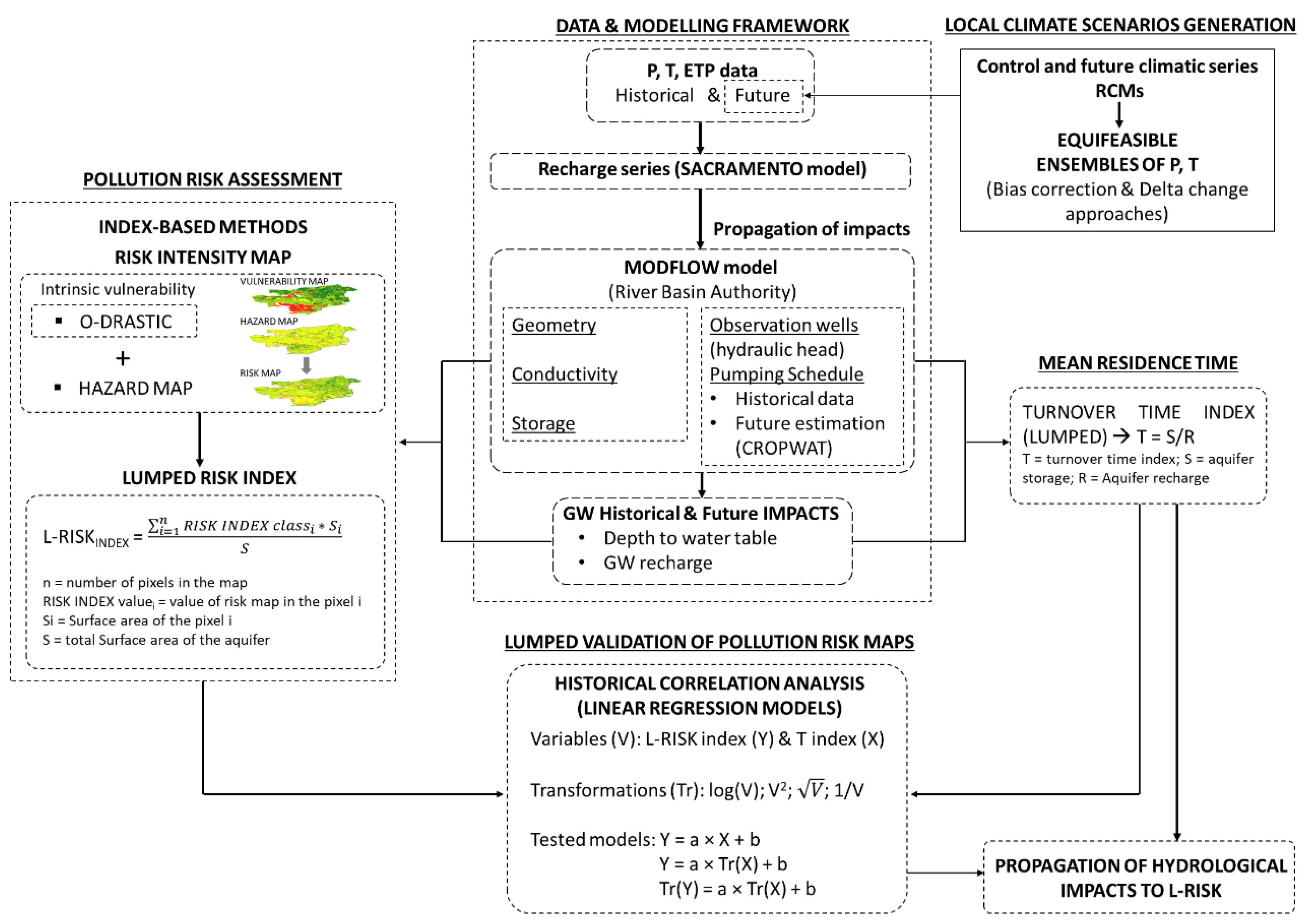
2.1. Methodology
2.1.1. Pollution Risk Assessment
2.1.2. Mean Residence Time
2.1.3. Lumped Validation of Pollution Risk Maps
2.1.4. Propagation of Hydrological Impacts to L-RISK
2.2. Study Area, Data and Modelling Framework
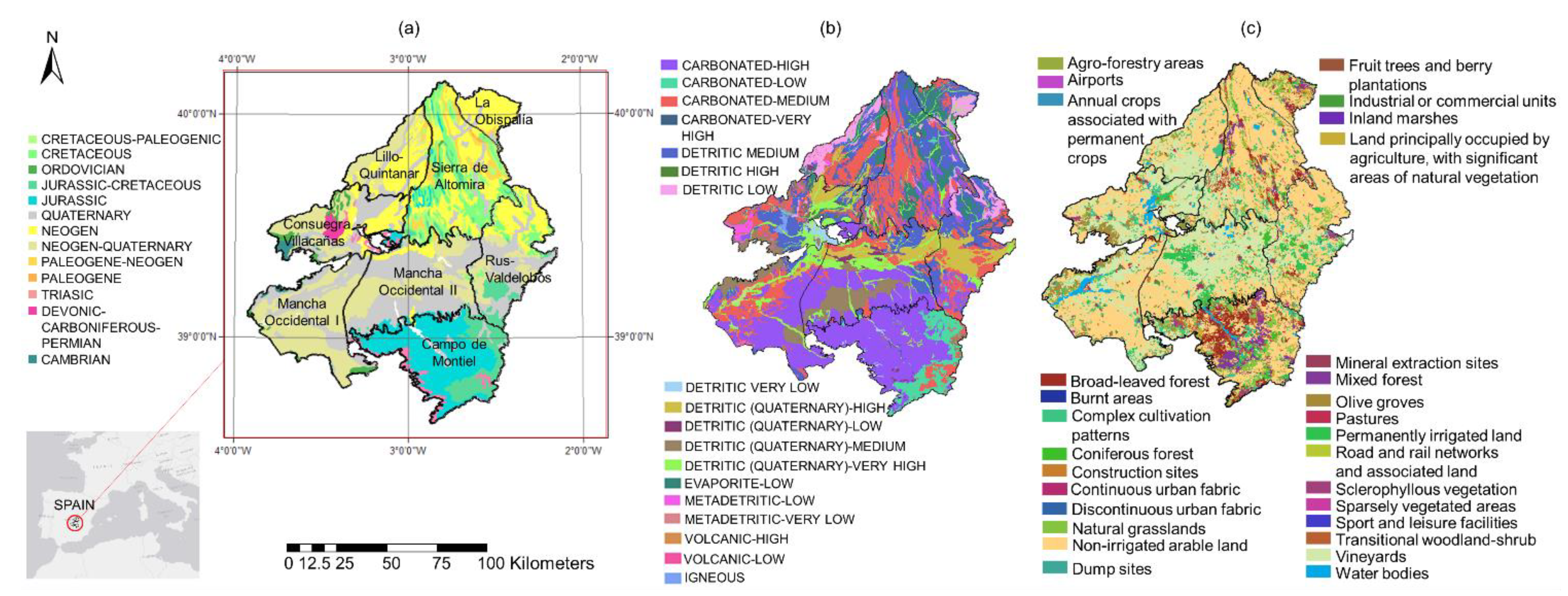
2.2.1. Location, Hydrogeology and Historical Climatic Data
2.2.2. Groundwater Flow (Modflow) Model
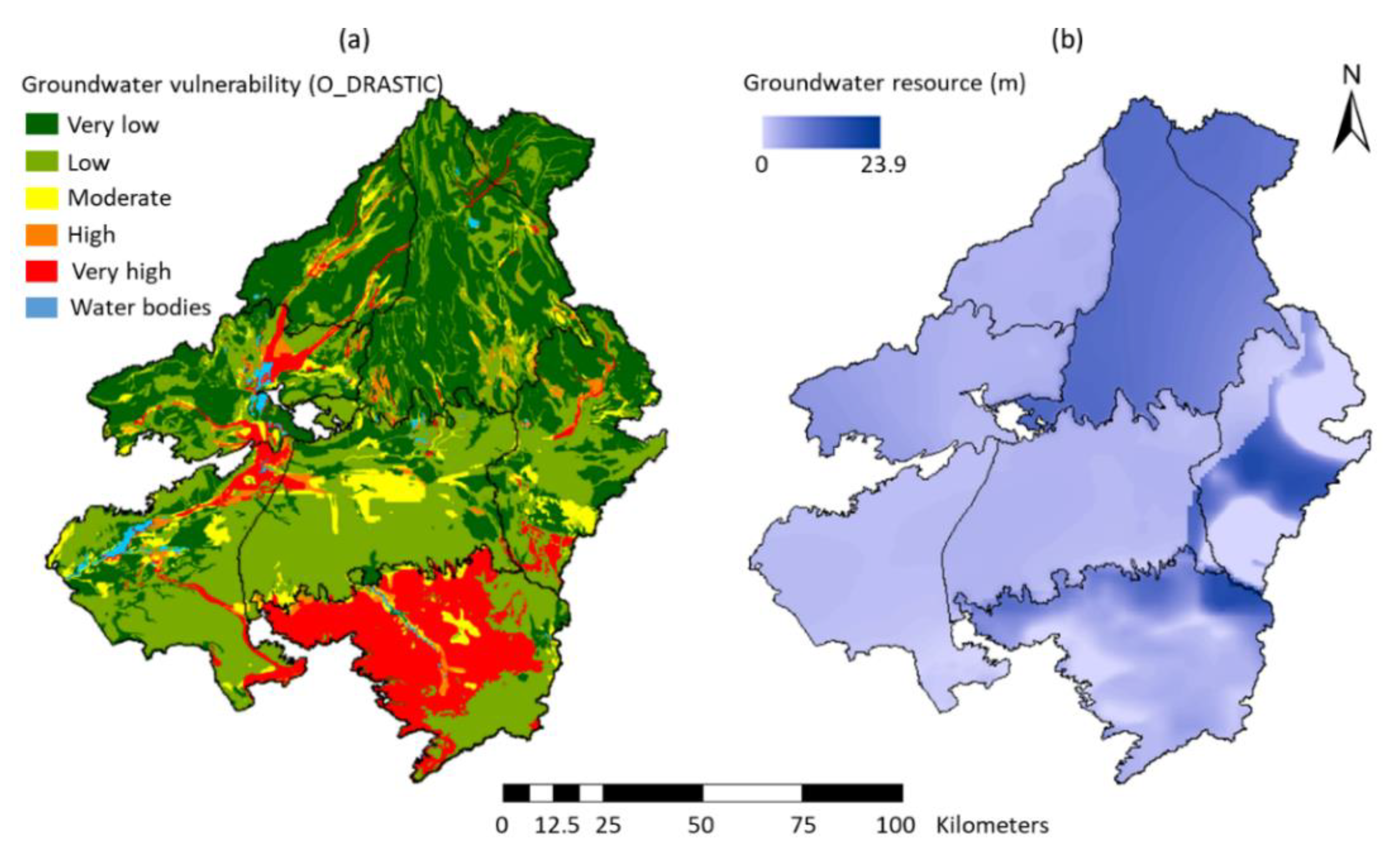
2.2.3. Vulnerability Map
2.2.4. Groundwater Resource Map
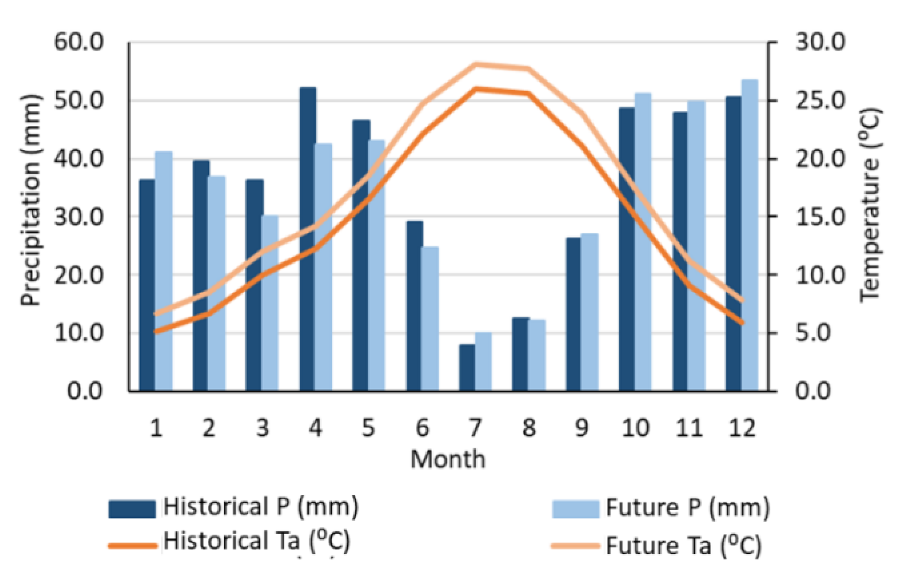
2.2.5. Generation of Local Climate Scenarios
3. Results and Discussion
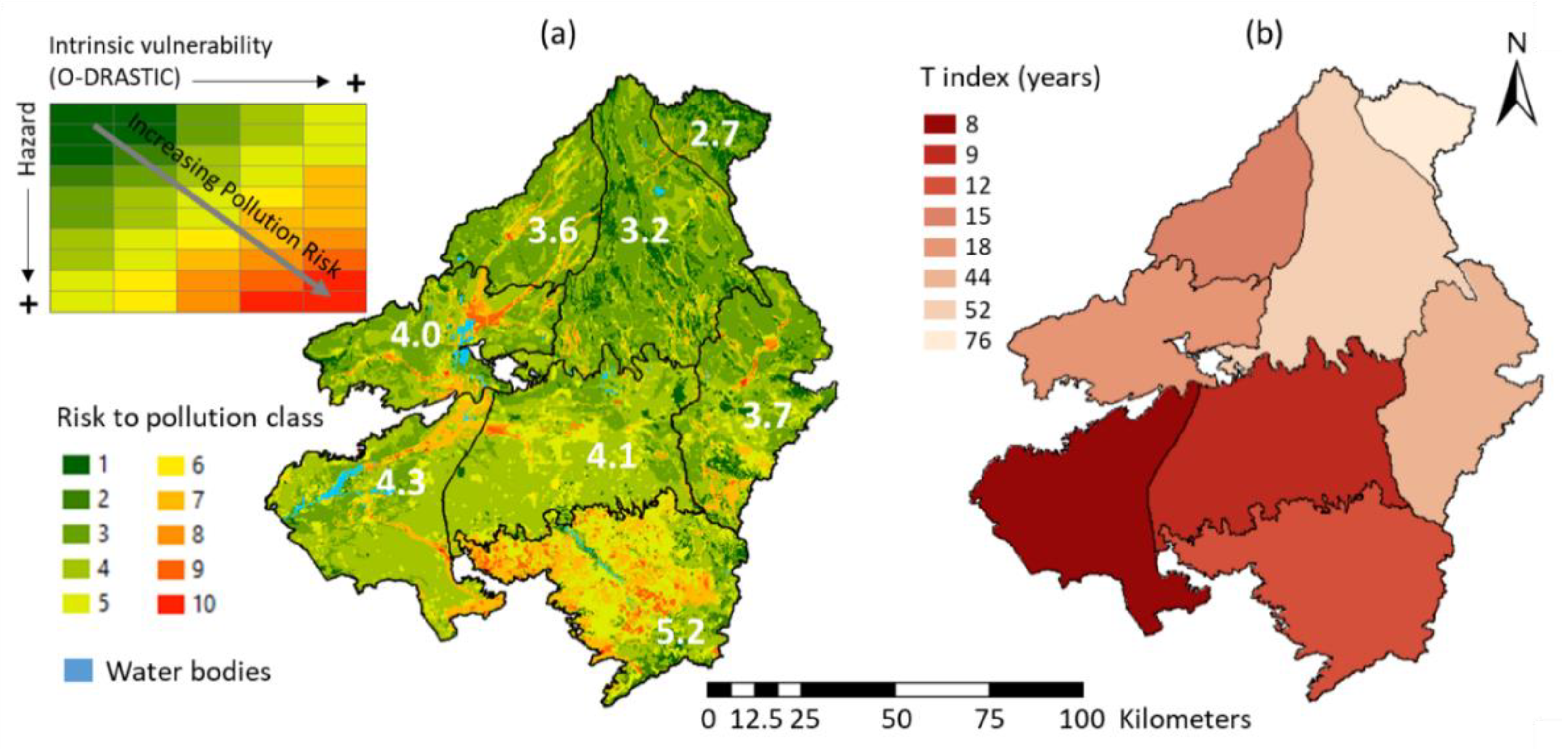
3.1. Pollution Risk Assessment
3.2. Mean Residence Time
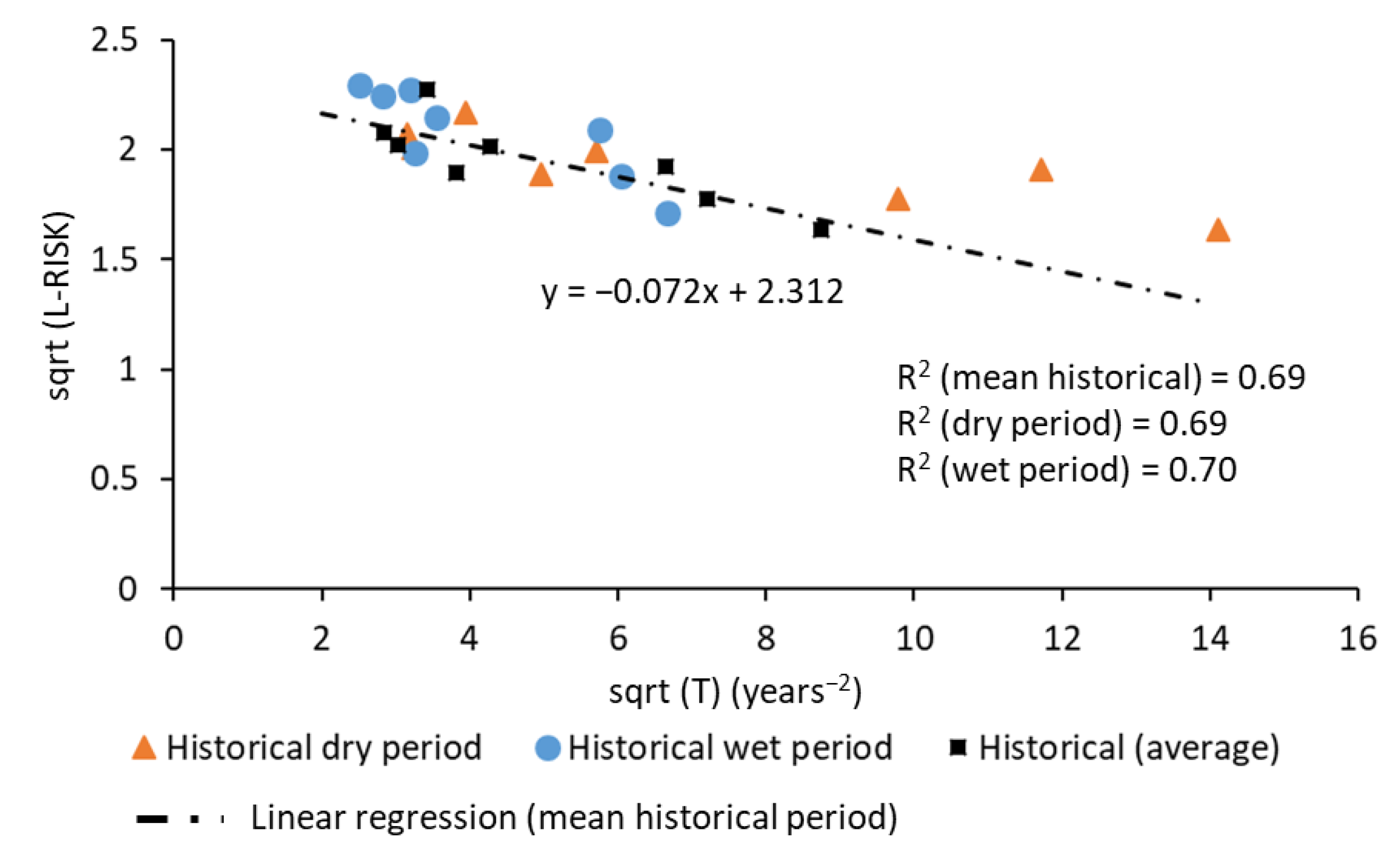
3.3. Lumped Validation of Pollution Risk Maps
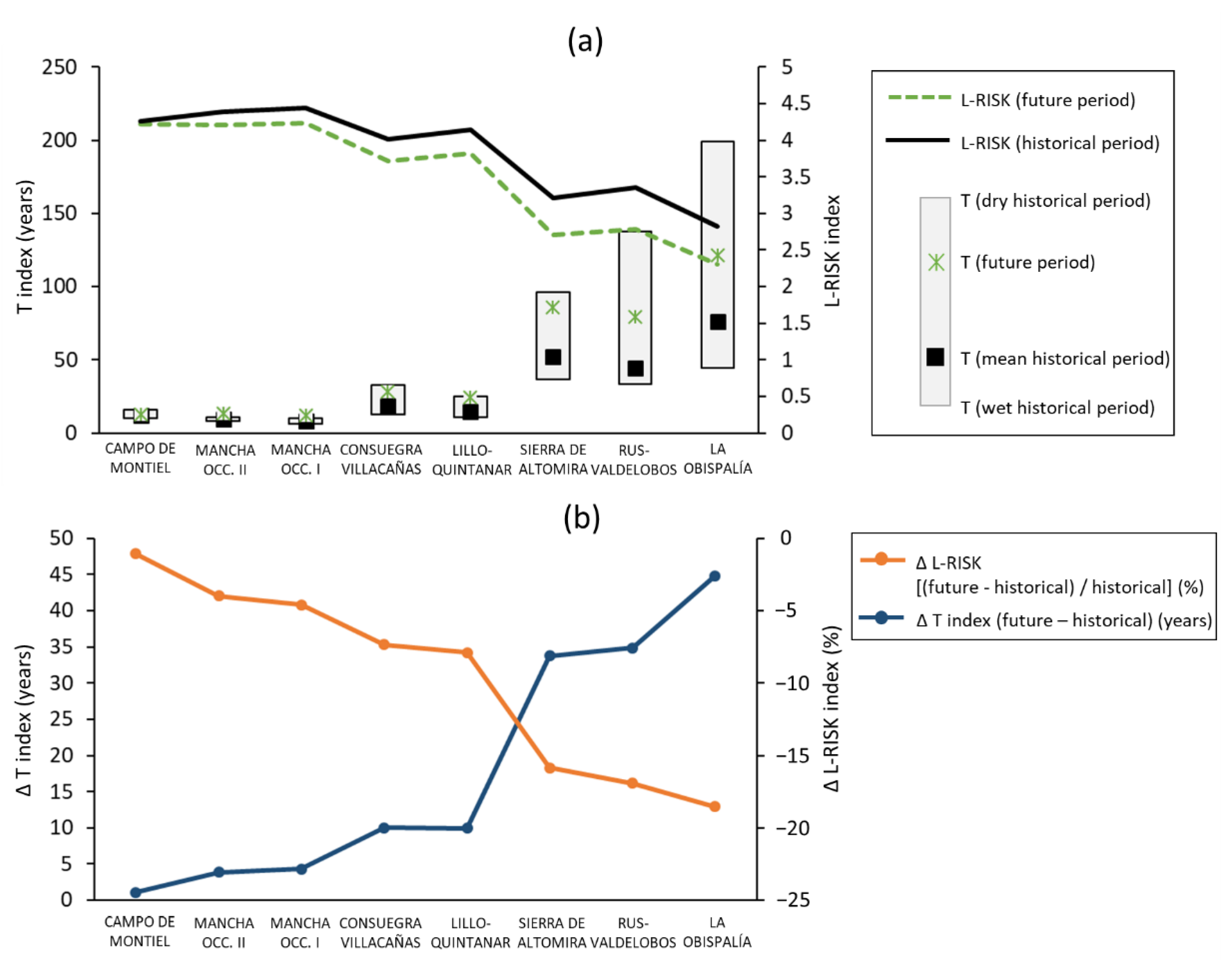
3.4. Impacts of Future Potential Climatic Scenarios
3.5. Hypotheses and Limitations
3.5.1. Data
- The hazard assessment considered the potential contamination from the different land uses based on the literature, but it did not consider the permissible quantity of fertilizers applicable according to the type of crop (which involves the potential load of nitrate into groundwater). This would require a complex analysis that was out of scope of this paper.
- The underlying vulnerability method may have involved some degree of subjectivity due to the own formulation of the method.
- Data to calculate the necessary variables for the T and L-RISK indices came from a calibrated flow model, which presented its own limitations.
- The climatic variables (precipitation and temperature) used in this study came from Spain02 project dataset [57]. This dataset has been employed and validated in many research studies.
3.5.2. Method
- The proposed method required a risk for pollution assessment, which could have involved some degree of subjectivity in the analysis. In this paper, a modification of the DRASTIC method (O-DRASTIC) was used to assess groundwater vulnerability, and it was combined with land uses to obtain the risk of pollution. Other vulnerability and/or risk assessment methods could be used to apply the proposed methodology.
- The T index could be obtained from available data from river basin authorities or by using a detailed groundwater model. The source of these data could influence the accuracy of results.
- We assumed a linear relationship between the mean residence time (T index) and the lumped risk of pollution (L-RISK index) in the studied aquifers. This allowed us to use a simple regression model.
- We assumed that the model was suitable in the range of variability of the future climatic variables.
- The method was demonstrated to be useful in the eight aquifers of the Upper Guadiana Basin, but it should be tested in a larger range of aquifers.
- The local climatic scenario used in this study was generated for the horizon of 2016-2045, assuming the most pessimistic emissions scenario (RCP 8.5). Observed biases were corrected by applying a simple statistical correction technique.
- The proposed method was useful to analyze the impacts of climate change on the risk of pollution at the aquifer scale, assuming that a business-as-usual management scenario was maintained in the future. Significant changes in the type of crops, which may involve higher fertilizer requirements, would have great impact on groundwater contamination, and the linear model would not allow one to approach a future assessment.
4. Conclusions
Author Contributions
Funding
Institutional Review Board Statement
Informed Consent Statement
Data Availability Statement
Acknowledgments
Conflicts of Interest
Appendix A. O-DRASTIC Method

| Groundwater Table Depth (m) | |
| Ranges | Ratings |
| 0–1.5 | 10 |
| 1.5–4.6 | 9 |
| 4.6–9.1 | 7 |
| 9.1–15.2 | 5 |
| 15.1–22.9 | 3 |
| 22.9–30.5 | 2 |
| >30.5 | 1 |
| Net recharge (mm) | |
| Ranges | Ratings |
| 0–50.8 | 1 |
| 50.8–101.6 | 3 |
| 101.6–177.8 | 6 |
| 177.8–254.0 | 8 |
| >254.0 | 9 |
| Aquifer media | |
| Ranges | Ratings |
| Massive shale | 2 |
| Metamorphic/Igneous | 3 |
| Weathered metamorphic/Igneous | 4 |
| Thin bedded sandstone, Limestone | 6 |
| Shale sequences | 6 |
| Massive sandstone | 6 |
| Massive limestone | 8 |
| Sand and gravel | 9 |
| Basalt | 10 |
| Karst limestone | |
| Soil media | |
| Ranges | Ratings |
| Thin or absent | 10 |
| Gravel | 10 |
| Sand | 9 |
| Peat | 8 |
| Shrinking and/or aggregated clay | 7 |
| Sandy loam | 6 |
| Loam | 5 |
| Silty loam | 4 |
| Clay loam | 3 |
| Muck | 2 |
| Non-shrinking and non-aggregated clay | 1 |
| Topography (% slope) | |
| Ranges | Ratings |
| 0–2 | 10 |
| 2–6 | 9 |
| 6–12 | 5 |
| 12–18 | 3 |
| >18 | 1 |
| Impact of vadose zone | |
| Ranges | Ratings |
| Silt/Clay | 1 |
| Shale | 3 |
| Limestone | 6 |
| Sandstone | 6 |
| Bedded limestone, sandstone, shale | 6 |
| Sand and gravel with significant silt and clay | 6 |
| Metamorphic/Igneous | 4 |
| Sand and gravel | 8 |
| Basalt | 9 |
| Karst limestone | 10 |
| Hydraulic conductivity (m/d) | |
| Ranges | Ratings |
| 15 | 1 |
| 30 | 2 |
| 45 | 4 |
| 60 | 6 |
| 75 | 8 |
| >75 | 10 |
| O-DRASTIC Index | Class Value |
|---|---|
| <107 | Very low |
| 107–130 | Low |
| 130–138 | Moderate |
| 138–146 | High |
| >146 | Very high |
References
- Quevauviller, P. Chapter 1. General Introduction: The Need to Protect Groundwater. In Groundwater Science and Policy; Royal Society of Chemistry (RSC): London, UK, 2007; pp. 1–18. [Google Scholar]
- Molina, J.-L.; Martos-Rosillo, S.; Martín-Montañés, C.; Pierce, S. The Social Sustainable Aquifer Yield: An Indicator for the Analysis and Assessment of the Integrated Aquifers Management. Water Resour. Manag. 2012, 26, 2951–2971. [Google Scholar] [CrossRef]
- Kløve, B.; Ala-Aho, P.; Bertrand, G.; Gurdak, J.J.; Kupfersberger, H.; Kværner, J.; Muotka, T.; Mykrä, H.; Preda, E.; Rossi, P.; et al. Climate change impacts on groundwater and dependent ecosystems. J. Hydrol. 2014, 518, 250–266. [Google Scholar] [CrossRef]
- Water Framework Directive Directive 2000/60/EC of the European Parliament and of the Council of 23 October 2000 establishing a framework for Community action in the field of water policy. Off. J. Eur. Parliam. 2000. Available online: https://eur-lex.europa.eu/eli/dir/2000/60/oj (accessed on 27 March 2021).
- Stigter, T.; Ribeiro, L.; Dill, A.C. Building factorial regression models to explain and predict nitrate concentrations in groundwater under agricultural land. J. Hydrol. 2008, 357, 42–56. [Google Scholar] [CrossRef]
- Aller, L.; Bennett, T.; Lehr, J.H.; Petty, R.J.; Hackett, G. DRASTIC: A Standardized Method for Evaluating Ground Water Pollution Potential Using Hydrogeologic Settings; NWWA/Epa-600/2-87-035; Kerr Environmental Research Laboratory, Office of Research and Development, US Environmental Protection Agency: Washington, DC, USA, 1987.
- Vías, J.M.; Andreo, B.; Perles, M.J.; Carrasco, F.; Vadillo, I.; Jiménez, P. Proposed method for groundwater vulnerability mapping in carbonate (karstic) aquifers: The COP method. Hydrogeol. J. 2006, 14, 912–925. [Google Scholar] [CrossRef]
- Kumar, P.; Bansod, B.K.; Debnath, S.K.; Thakur, P.K.; Ghanshyam, C. Index-based groundwater vulnerability mapping models using hydrogeological settings: A critical evaluation. Environ. Impact Assess. Rev. 2015, 51, 38–49. [Google Scholar] [CrossRef]
- Garcet, J.P.; Ordoñez, A.; Roosen, J.; Vanclooster, M. Metamodelling: Theory, concepts and application to nitrate leaching modelling. Ecol. Model. 2006, 193, 629–644. [Google Scholar] [CrossRef]
- Oke, S.A. An overview of aquifer vulnerability. In Aquifers: Properties, Roles and Research; Nova Science Publishers, Inc.: Hauppauge, NY, USA, 2017; ISBN 9781536110845. [Google Scholar]
- Baena-Ruiz, L.; Pulido-Velazquez, D.; Collados-Lara, A.-J.; Renau-Pruñonosa, A.; Morell, I. Global Assessment of Seawater Intrusion Problems (Status and Vulnerability). Water Resour. Manag. 2018, 32, 2681–2700. [Google Scholar] [CrossRef]
- Baena-Ruiz, L.; Pulido-Velazquez, D.; Collados-Lara, A.-J.; Renau-Pruñonosa, A.; Morell, I.; Senent-Aparicio, J.; Llopis-Albert, C. Summarizing the impacts of future potential global change scenarios on seawater intrusion at the aquifer scale. Environ. Earth Sci. 2020, 79, 1–13. [Google Scholar] [CrossRef]
- Vías, J.; Andreo, B.; Ravbar, N.; Hötzl, H. Mapping the vulnerability of groundwater to the contamination of four carbonate aquifers in Europe. J. Environ. Manag. 2010, 91, 1500–1510. [Google Scholar] [CrossRef] [PubMed]
- Zwahlen, F. COST Action 620 Vulnerability and Risk Mapping for the Protection of Carbonate (Karst) Aquifers Final Report; Office of the Official Publications of the European Communities: Brussels, Belgium, 2003; ISBN 928946416X. [Google Scholar]
- Dąbrowska, D.; Witkowski, A.J.; Sołtysiak, M. Application of pollution indices for the spatiotemporal assessment of negative impact of a municipal landfill on groundwater (Tychy, southern Poland). Geol. Q. 2018, 62, 496. [Google Scholar] [CrossRef]
- Sołtysiak, M.; Dabrowska, D.; Jałowiecki, K.; Nourani, V. A multi-method approach to groundwater risk assessment: A case study of a landfill in southern Poland. Geol. Q. 2018, 62, 361. [Google Scholar] [CrossRef]
- Backman, B.; Bodiš, D.; Lahermo, P.; Rapant, S.; Tarvainen, T. Application of a groundwater contamination index in Finland and Slovakia. Environ. Earth Sci. 1998, 36, 55–64. [Google Scholar] [CrossRef]
- Kumar Singh, P.; Verma, P.; Tiwari, A.K.; Sharma, S.; Purty, P. Review of various contamination index approaches to evaluate groundwater quality with geographic information system (GIS). Int. J. Chem. Tech. Res. 2014, 7, 1920. [Google Scholar]
- Baena-Ruiz, L.; Pulido-Velazquez, D. A Novel Approach to Harmonize Vulnerability Assessment in Carbonate and Detrital Aquifers at Basin Scale. Water 2020, 12, 2971. [Google Scholar] [CrossRef]
- Pulido-Velazquez, D.; Romero, J.; Collados-Lara, A.-J.; Alcalá, F.J.; Fernández-Chacón, F.; Baena-Ruiz, L. Using the Turnover Time Index to Identify Potential Strategic Groundwater Resources to Manage Droughts within Continental Spain. Water 2020, 12, 3281. [Google Scholar] [CrossRef]
- Newman, B.D.; Osenbrück, K.; Aeschbach-Hertig, W.; Solomon, D.K.; Cook, P.; Rozanski, K.; Kipfer, R.; Aeschbach, W. Dating of ‘young’ groundwaters using environmental tracers: Advantages, applications, and research needs. Isot. Environ. Health Stud. 2010, 46, 259–278. [Google Scholar] [CrossRef] [PubMed]
- Dedewanou, M.; Binet, S.; Rouet, J.L.; Coquet, Y.; Bruand, A.; Noel, H. Groundwater Vulnerability and Risk Mapping Based on Residence Time Distributions: Spatial Analysis for the Estimation of Lumped Parameters. Water Resour. Manag. 2015, 29, 5489–5504. [Google Scholar] [CrossRef]
- Schwartz, M.O. Numerical modelling of groundwater vulnerability: The example Namibia. Environ. Earth Sci. 2006, 50, 237–249. [Google Scholar] [CrossRef]
- Molson, J.; Frind, E. On the use of mean groundwater age, life expectancy and capture probability for defining aquifer vulnerability and time-of-travel zones for source water protection. J. Contam. Hydrol. 2012, 127, 76–87. [Google Scholar] [CrossRef]
- Živanović, V.; Jemcov, I.; Dragišić, V.; Atanacković, N.; Magazinović, S. Karst groundwater source protection based on the time-dependent vulnerability assessment model: Crnica springs case study, Eastern Serbia. Environ. Earth Sci. 2016, 75, 1224. [Google Scholar] [CrossRef]
- Andreo, B.; Goldscheider, N.; Vadillo, I.; Vías, J.M.; Neukum, C.; Sinreich, M.; Jiménez, P.; Brechenmacher, J.; Carrasco, F.; Hötzl, H.; et al. Karst groundwater protection: First application of a Pan-European Approach to vulnerability, hazard and risk mapping in the Sierra de Líbar (Southern Spain). Sci. Total Environ. 2006, 357, 54–73. [Google Scholar] [CrossRef] [PubMed]
- Neukum, C.; Hötzl, H.; Himmelsbach, T. Validation of vulnerability mapping methods by field investigations and numerical modelling. Hydrogeol. J. 2007, 16, 641–658. [Google Scholar] [CrossRef]
- Sadek, M.; El-Samie, A.S. Pollution vulnerability of the Quaternary aquifer near Cairo, Egypt, as indicated by isotopes and hydrochemistry. Hydrogeol. J. 2001, 9, 273–281. [Google Scholar] [CrossRef]
- Bakalowicz, M. Karst groundwater: A challenge for new resources. Hydrogeol. J. 2005, 13, 148–160. [Google Scholar] [CrossRef]
- Neukum, C.; Azzam, R. Quantitative assessment of intrinsic groundwater vulnerability to contamination using numerical simulations. Sci. Total Environ. 2009, 408, 245–254. [Google Scholar] [CrossRef]
- Yu, C.; Yao, Y.; Cao, G.; Zheng, C. A field demonstration of groundwater vulnerability assessment using transport modeling and groundwater age modeling, Beijing Plain, China. Environ. Earth Sci. 2014, 73, 5245–5253. [Google Scholar] [CrossRef]
- Chambers, L.; Gooddy, D.; Binley, A. Use and application of CFC-11, CFC-12, CFC-113 and SF6 as environmental tracers of groundwater residence time: A review. Geosci. Front. 2019, 10, 1643–1652. [Google Scholar] [CrossRef]
- Perrin, J.; Pochon, A.; Jeannin, P.-Y.; Zwahlen, F. Vulnerability assessment in karstic areas: Validation by field experiments. Environ. Earth Sci. 2004, 46, 237–245. [Google Scholar] [CrossRef]
- Green, T.R.; Taniguchi, M.; Kooi, H.; Gurdak, J.J.; Allen, D.M.; Hiscock, K.M.; Treidel, H.; Aureli, A. Beneath the surface of global change: Impacts of climate change on groundwater. J. Hydrol. 2011, 405, 532–560. [Google Scholar] [CrossRef]
- Cao, T.; Han, D.; Song, X.; Trolle, D. Subsurface hydrological processes and groundwater residence time in a coastal alluvium aquifer: Evidence from environmental tracers (δ18O, δ2H, CFCs, 3H) combined with hydrochemistry. Sci. Total Environ. 2020, 743, 140684. [Google Scholar] [CrossRef]
- Fienen, M.N.; Nolan, B.T.; Kauffman, L.J.; Feinstein, D.T. Metamodeling for Groundwater Age Forecasting in the Lake Michigan Basin. Water Resour. Res. 2018, 54, 4750–4766. [Google Scholar] [CrossRef]
- Martínez-Salvador, C.; Moreno-Gómez, M.; Liedl, R. Estimating Pollutant Residence Time and NO3 Concentrations in the Yucatan Karst Aquifer; Considerations for an Integrated Karst Aquifer Vulnerability Methodology. Water 2019, 11, 1431. [Google Scholar] [CrossRef]
- Jurgens, B.C.; Böhlke, J.; Kauffman, L.J.; Belitz, K.; Esser, B.K. A partial exponential lumped parameter model to evaluate groundwater age distributions and nitrate trends in long-screened wells. J. Hydrol. 2016, 543, 109–126. [Google Scholar] [CrossRef]
- Małoszewski, P.; Zuber, A. Determining the turnover time of groundwater systems with the aid of environmental tracers. 1. Models and their applicability. J. Hydrol. 1982, 57, 207–231. [Google Scholar] [CrossRef]
- Martos-Rosillo, S.; Marín-Lechado, C.; Pedrera, A.; Vadillo, I.; Motyka, J.; Molina, J.L.; Ortiz, P.; Ramírez, J.M.M. Methodology to evaluate the renewal period of carbonate aquifers: A key tool for their management in arid and semiarid regions, with the example of Becerrero aquifer, Spain. Hydrogeol. J. 2013, 22, 679–689. [Google Scholar] [CrossRef]
- Pulido-Velazquez, D.; Renau-Pruñonosa, A.; Llopis-Albert, C.; Morell, I.; Collados-Lara, A.-J.; Senent-Aparicio, J.; Baena-Ruiz, L. Integrated assessment of future potential global change scenarios and their hydrological impacts in coastal aquifers—A new tool to analyse management alternatives in the Plana Oropesa-Torreblanca aquifer. Hydrol. Earth Syst. Sci. 2018, 22, 3053–3074. [Google Scholar] [CrossRef]
- Musálem, K.; McDonald, M.; Jiménez, F.; Laino, R. Groundwater vulnerability mapping in two watersheds affected by Yacyreta Dam in Paraguay. Tecnol. Ciencias Agua 2015, 6, 49–61. [Google Scholar]
- Ducci, D. Influence of climate changes on vulnerability maps. In Proceedings of the First Conference and Workshop on “Groundwater and Climate Change”, Norwich, UK, 4–6 April 2005. [Google Scholar]
- Huang, L.; Zeng, G.; Liang, J.; Hua, S.; Yuan, Y.; Li, X.; Dong, H.; Liu, J.; Nie, S.; Liu, J. Combined Impacts of Land Use and Climate Change in the Modeling of Future Groundwater Vulnerability. J. Hydrol. Eng. 2017, 22, 05017007. [Google Scholar] [CrossRef]
- Ouedraogo, I.; Girard, A.; Vanclooster, M.; Jonard, F. Modelling the Temporal Dynamics of Groundwater Pollution Risks at the African Scale. Water 2020, 12, 1406. [Google Scholar] [CrossRef]
- Nistor, M.-M. Groundwater vulnerability in Europe under climate change. Quat. Int. 2020, 547, 185–196. [Google Scholar] [CrossRef]
- Collados-Lara, A.-J.; Pulido-Velazquez, D.; Mateos, R.M.; Ezquerro, P. Potential Impacts of Future Climate Change Scenarios on Ground Subsidence. Water 2020, 12, 219. [Google Scholar] [CrossRef]
- Morris, B.L.; Foster, S.D. Cryptosporidium contamination hazard assessment and risk management for British groundwater sources. Water Sci. Technol. 2000, 41, 67–77. [Google Scholar] [CrossRef]
- Causapé, J.; Quílez, D.; Aragüés, R. Assessment of irrigation and environmental quality at the hydrological basin level: II. Salt and nitrate loads in irrigation return flows. Agric. Water Manag. 2004, 70, 211–228. [Google Scholar] [CrossRef]
- Merchán, D.; Otero, N.; Soler, A.; Causapé, J. Main sources and processes affecting dissolved sulphates and nitrates in a small irrigated basin (Lerma Basin, Zaragoza, Spain): Isotopic characterization. Agric. Ecosyst. Environ. 2014, 195, 127–138. [Google Scholar] [CrossRef]
- Dunn, S.; Brown, I.; Sample, J.; Post, H. Relationships between climate, water resources, land use and diffuse pollution and the significance of uncertainty in climate change. J. Hydrol. 2012, 434–435, 19–35. [Google Scholar] [CrossRef]
- Werz, H.; Hötzl, H. Groundwater risk intensity mapping in semi-arid regions using optical remote sensing data as an additional tool. Hydrogeol. J. 2007, 15, 1031–1049. [Google Scholar] [CrossRef]
- Kazakis, N.; Voudouris, K.S. Groundwater vulnerability and pollution risk assessment of porous aquifers to nitrate: Modifying the DRASTIC method using quantitative parameters. J. Hydrol. 2015, 525, 13–25. [Google Scholar] [CrossRef]
- Conan, C.; De Marsily, G.; Bouraoui, F.; Bidoglio, G. A long-term hydrological modelling of the Upper Guadiana river basin (Spain). Phys. Chem. Earth Parts A/B/C 2003, 28, 193–200. [Google Scholar] [CrossRef]
- Yustres, Á.; Navarro, V.; Asensio, L.; Candel, M.; García, B. Groundwater resources in the Upper Guadiana Basin (Spain): A regional modelling analysis. Hydrogeol. J. 2013, 21, 1129–1146. [Google Scholar] [CrossRef]
- Martinezsantos, P.; Llamas, M.; Martinezalfaro, P. Vulnerability assessment of groundwater resources: A modelling-based approach to the Mancha Occidental aquifer, Spain. Environ. Model. Softw. 2008, 23, 1145–1162. [Google Scholar] [CrossRef]
- Herrera, S.; Fernández, J.; Gutiérrez, J.M. Update of the Spain02 gridded observational dataset for EURO-CORDEX evaluation: Assessing the effect of the interpolation methodology. Int. J. Clim. 2016, 36, 900–908. [Google Scholar] [CrossRef]
- World Climate Research Programme. The Coordinated Regional Climate Downscaling Experiment (CORDEX); World Climate Research Programme: Geneva, Switzerland, 2013; Available online: http://www.cordex.org/ (accessed on 27 March 2021).
- Panagopoulos, G.P.; Antonakos, A.K.; Lambrakis, N.J. Optimization of the DRASTIC method for groundwater vulnerability assessment via the use of simple statistical methods and GIS. Hydrogeol. J. 2006, 14, 894–911. [Google Scholar] [CrossRef]
- Antonakos, A.; Lambrakis, N. Development and testing of three hybrid methods for the assessment of aquifer vulnerability to nitrates, based on the drastic model, an example from NE Korinthia, Greece. J. Hydrol. 2007, 333, 288–304. [Google Scholar] [CrossRef]
- Lapworth, D.J.; Macdonald, A.M.; Tijani, M.N.; Darling, G.; Gooddy, D.C.; Bonsor, H.C.; Araguás-Araguás, L.J. Residence times of shallow groundwater in West Africa: Implications for hydrogeology and resilience to future changes in climate. Hydrogeol. J. 2013, 21, 673–686. [Google Scholar] [CrossRef]
- Wachniew, P. Environmental tracers as a tool in groundwater vulnerability assessment. Acque Sotter. Ital. J. Groundw. 2015, 4. [Google Scholar] [CrossRef]
- Smith, M. CROPWAT: A Computer Program. for Irrigation Planning and Management; Food & Agriculture Organization: Rome, Italy, 1992; ISBN 9251031061. [Google Scholar]
- Duda, R.; Kowalczyk, P. Assessment of factors affecting the intrinsic vulnerability of groundwater rated by the mean residence time estimation method. Geol. Q. 2019, 63, 126–138. [Google Scholar] [CrossRef]


| TR(y) = a × TR (x) + b | TR (x) | |||||
|---|---|---|---|---|---|---|
| - | x2 | 1/x | ||||
| TR(y) | - | * | * | * | * | * |
| y2 | - | * | - | - | - | |
| - | - | * | - | - | ||
| Log(y) | - | - | - | * | - | |
| 1/y | - | - | - | - | * | |
| LU | Rate |
|---|---|
| Agroforestry areas | 7 |
| Airports | 2 |
| Annual crops associated with permanent crops | 8 |
| Broad-leaved forest | 2 |
| Burnt areas | 2 |
| Complex cultivation patterns | 8 |
| Coniferous forest | 2 |
| Construction sites | 2 |
| Continuous urban fabric | 10 |
| Discontinuous urban fabric | 10 |
| Dump sites | 9 |
| Fruit trees and berry plantations | 7 |
| Industrial or commercial units | 8 |
| Inland marshes | 1 |
| Land principally occupied by agriculture, with significant areas of natural vegetation | 5 |
| Mineral extraction sites | 3 |
| Mixed forest | 3 |
| Natural grasslands | 3 |
| Non-irrigated arable land | 5 |
| Olive groves | 6 |
| Pastures | 5 |
| Permanently irrigated land | 8 |
| Road and rail networks and associated land | 2 |
| Sclerophyllous vegetation | 3 |
| Sparsely vegetated areas | 3 |
| Sport and leisure facilities | 2 |
| Transitional woodland-shrub | 2 |
| Vineyards | 5 |
| Water bodies | 1 |
Publisher’s Note: MDPI stays neutral with regard to jurisdictional claims in published maps and institutional affiliations. |
© 2021 by the authors. Licensee MDPI, Basel, Switzerland. This article is an open access article distributed under the terms and conditions of the Creative Commons Attribution (CC BY) license (https://creativecommons.org/licenses/by/4.0/).
Share and Cite
Baena-Ruiz, L.; Pulido-Velazquez, D.; Collados-Lara, A.-J.; Gómez-Gómez, J.-d.-D. A Preliminary Lumped Assessment of Pollution Risk at Aquifer Scale by Using the Mean Residence Time. Analyses of Potential Climate Change Impacts. Water 2021, 13, 943. https://doi.org/10.3390/w13070943
Baena-Ruiz L, Pulido-Velazquez D, Collados-Lara A-J, Gómez-Gómez J-d-D. A Preliminary Lumped Assessment of Pollution Risk at Aquifer Scale by Using the Mean Residence Time. Analyses of Potential Climate Change Impacts. Water. 2021; 13(7):943. https://doi.org/10.3390/w13070943
Chicago/Turabian StyleBaena-Ruiz, Leticia, David Pulido-Velazquez, Antonio-Juan Collados-Lara, and Juan-de-Dios Gómez-Gómez. 2021. "A Preliminary Lumped Assessment of Pollution Risk at Aquifer Scale by Using the Mean Residence Time. Analyses of Potential Climate Change Impacts" Water 13, no. 7: 943. https://doi.org/10.3390/w13070943
APA StyleBaena-Ruiz, L., Pulido-Velazquez, D., Collados-Lara, A.-J., & Gómez-Gómez, J.-d.-D. (2021). A Preliminary Lumped Assessment of Pollution Risk at Aquifer Scale by Using the Mean Residence Time. Analyses of Potential Climate Change Impacts. Water, 13(7), 943. https://doi.org/10.3390/w13070943