
Effect of Watershed Delineation and Climate Datasets Density on Runoff Predictions for the Upper Mississippi River Basin Using SWAT within HAWQS


Abstract
:1. Introduction
2. Materials and Methods
2.1. Model Description and Configuration
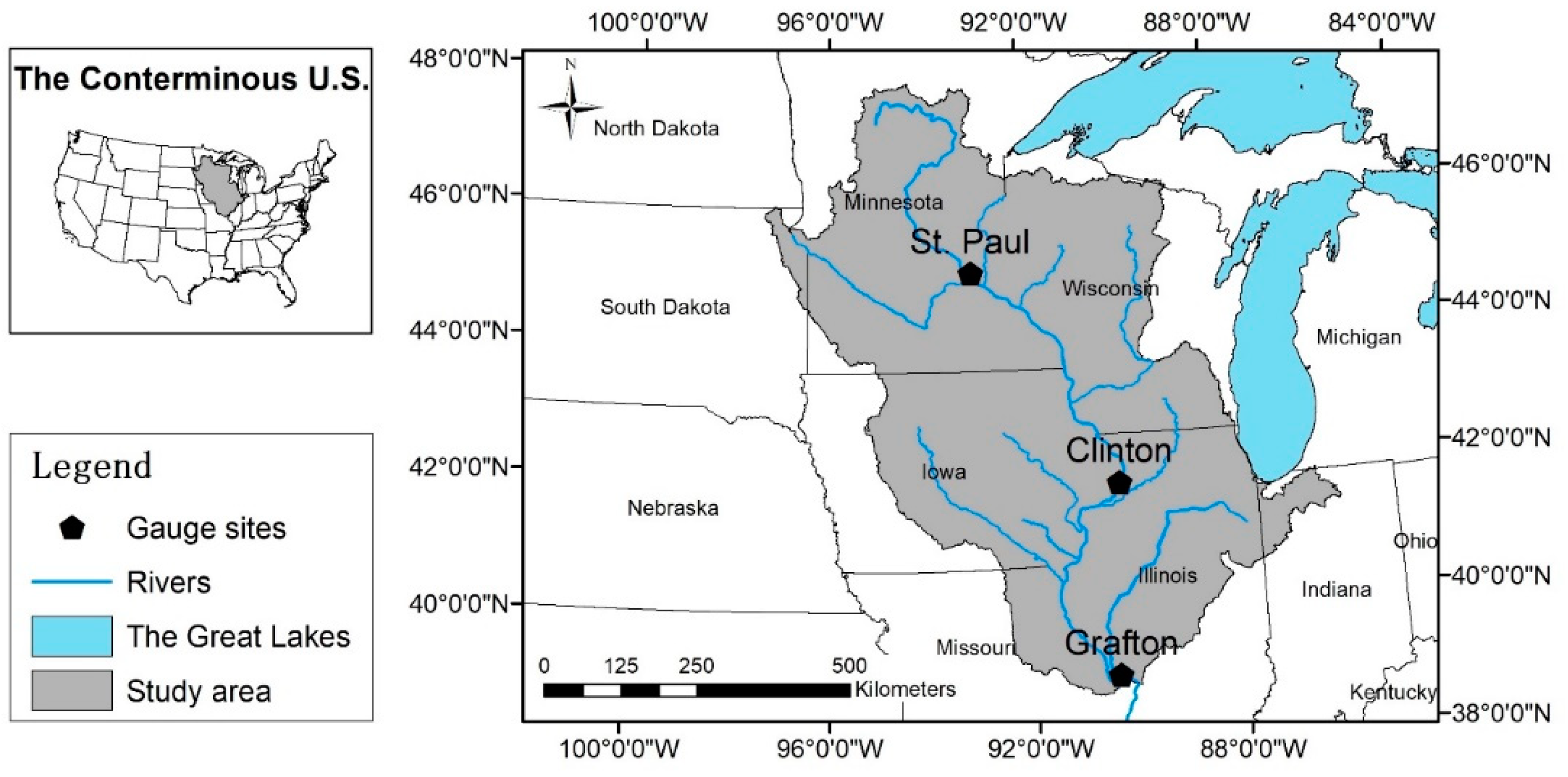
2.2. Study Area
2.3. Watershed Delineation and Climate Datasets
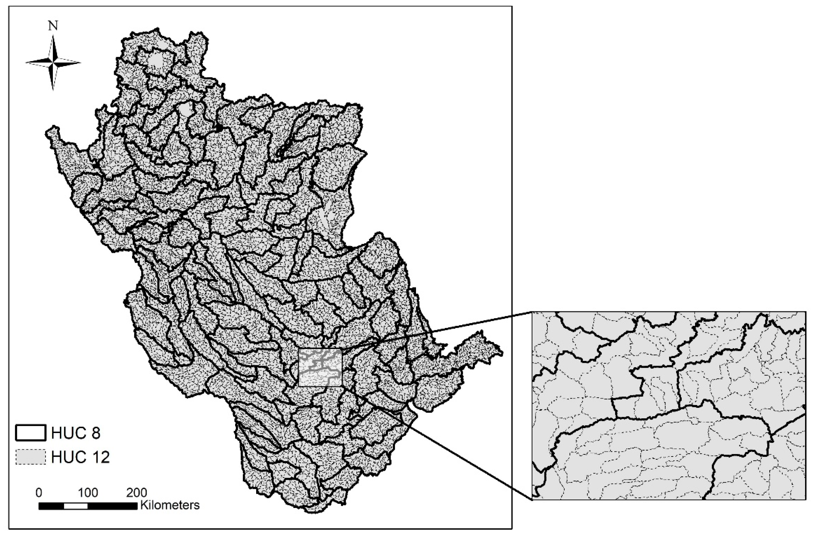
2.3.1. Watershed Delineation
2.3.2. Spatial Climate Datasets
2.4. Simulation Scenario
3. Results and Discussion
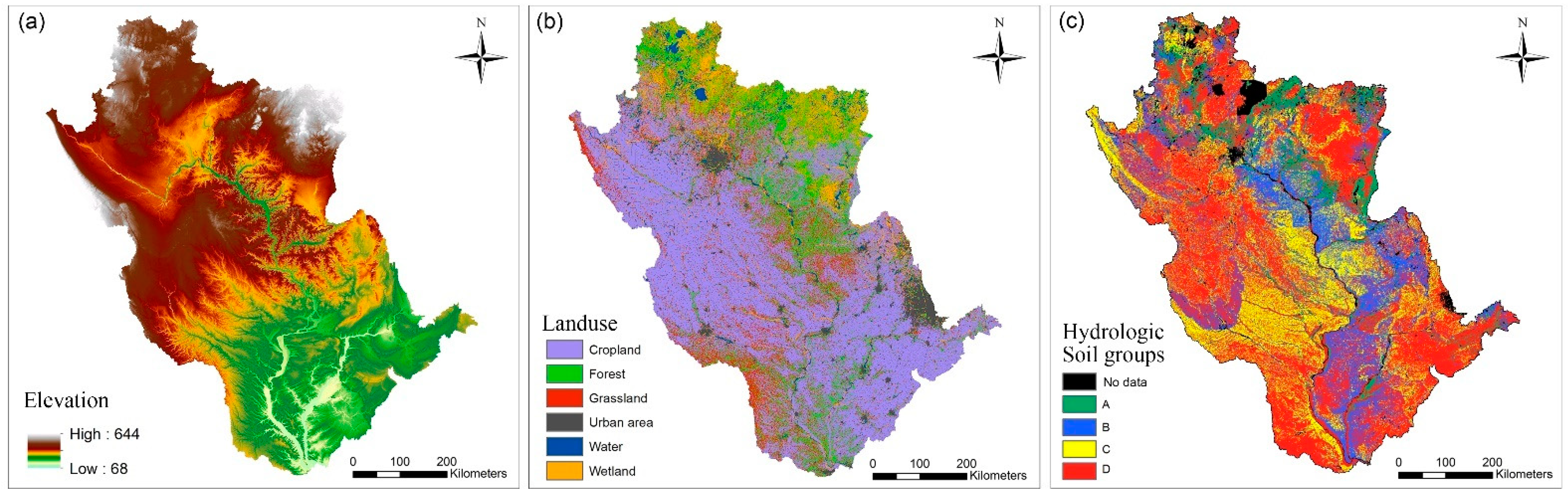
3.1. Land-Use, Soil and Landscape Discrepancies from Different Delineations
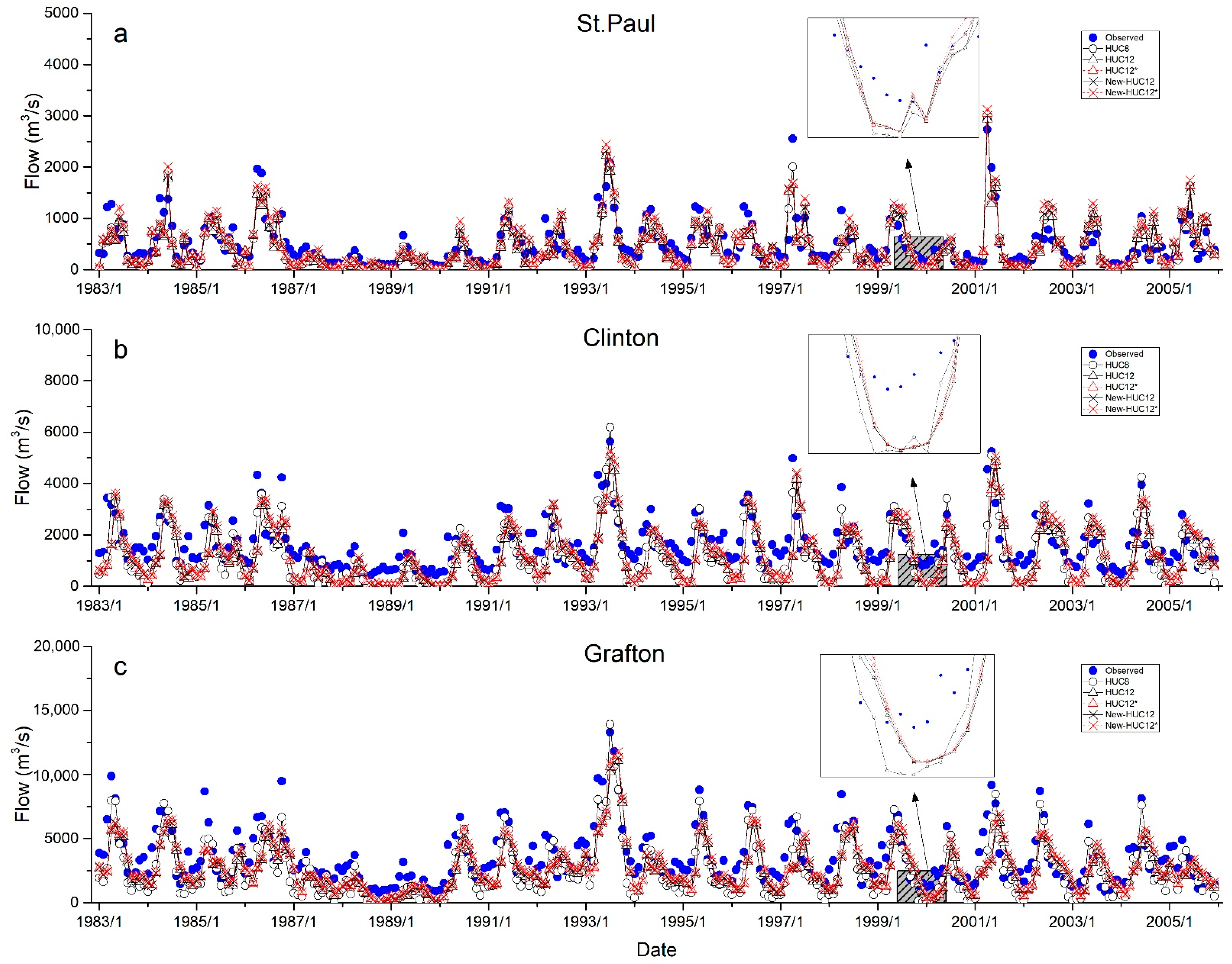
3.2. Evaluation of Monthly Streamflow at Gauge Sites
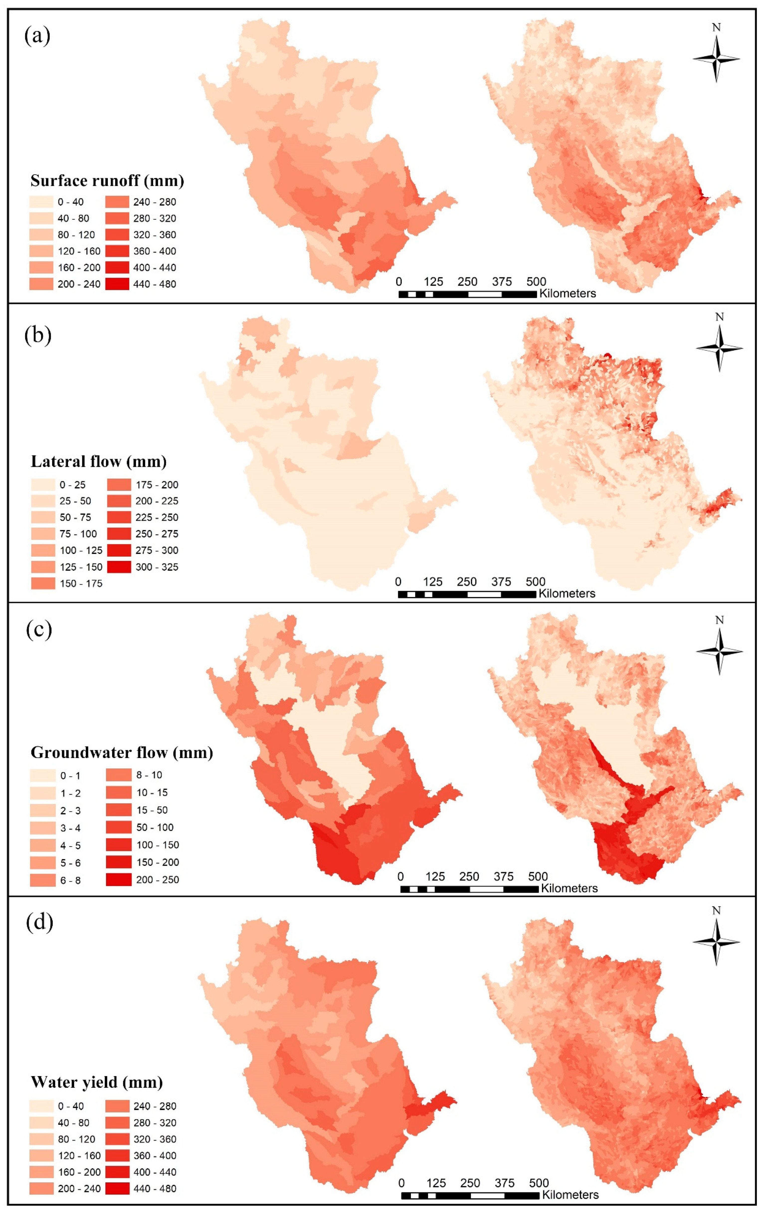
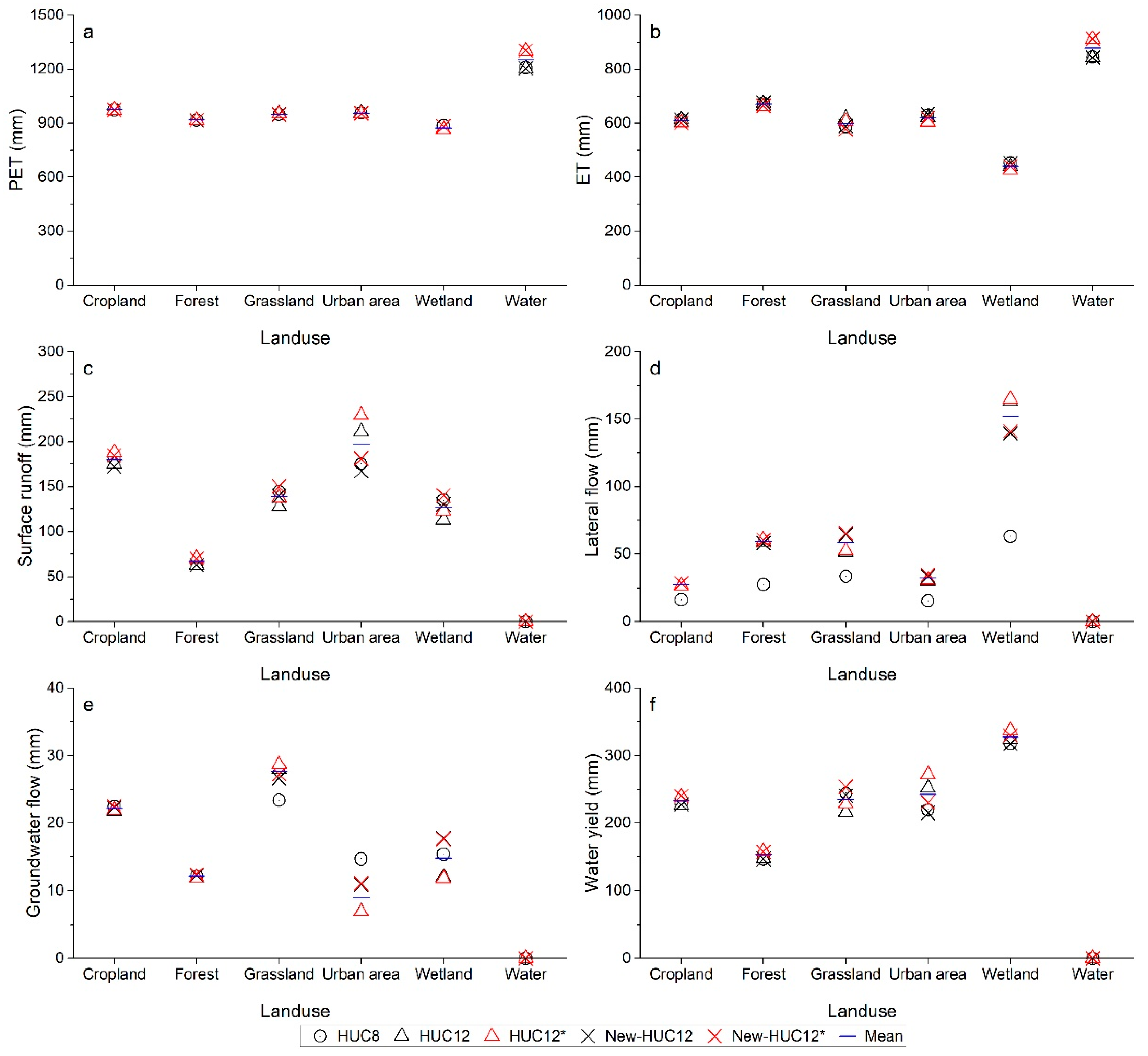
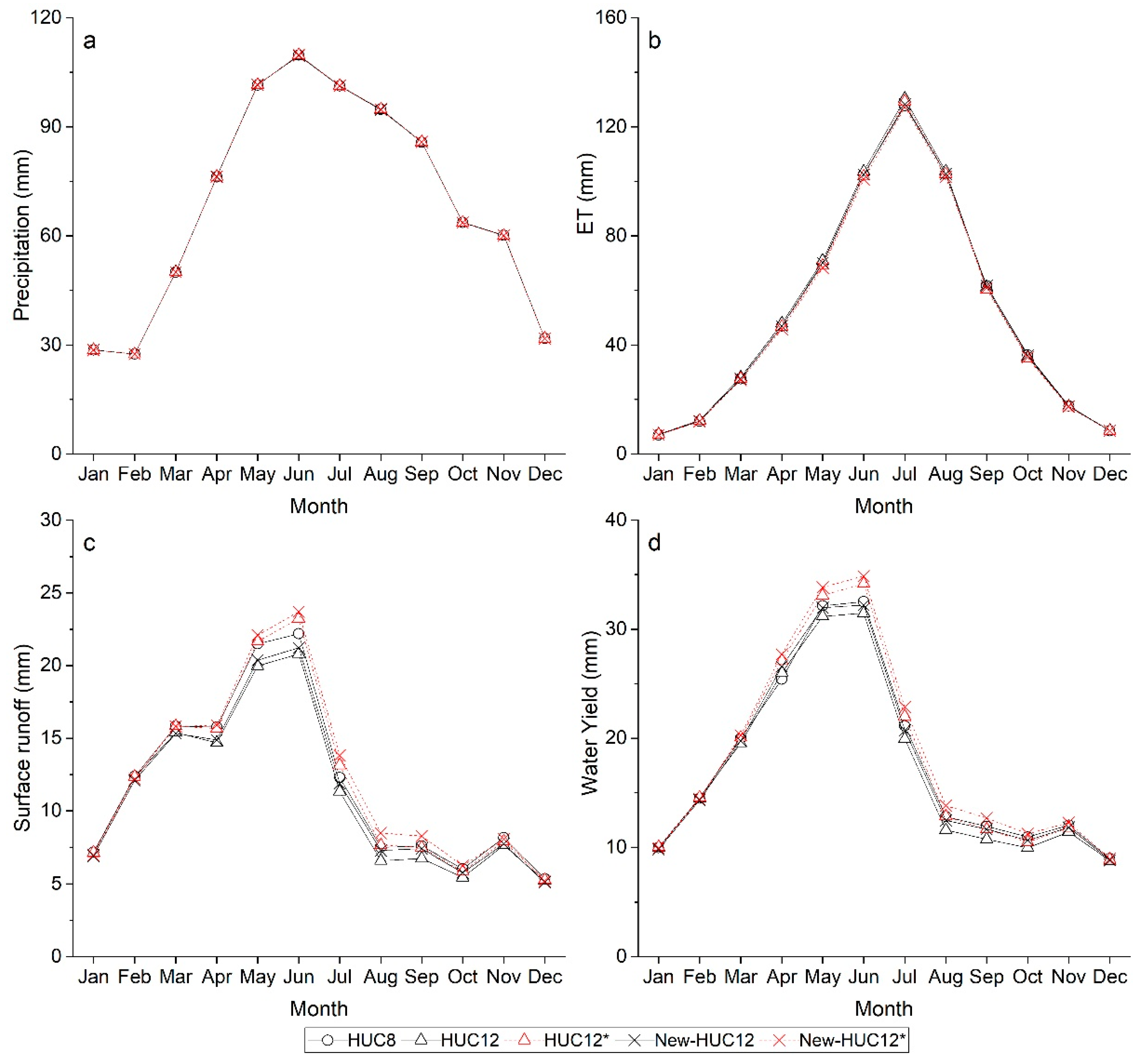
3.3. Response of Hydrologic Components
3.4. Effect of the Spatial Density of Climate Dataset on Runoff
4. Conclusions
Author Contributions
Funding
Institutional Review Board Statement
Informed Consent Statement
Data Availability Statement
Acknowledgments
Conflicts of Interest
References
- Teshager, A.D.; Gassman, P.W.; Schoof, J.T.; Secchi, S. Assessment of impacts of agricultural and climate change scenarios on watershed water quantity and quality, and crop production. Hydrol. Earth Syst. Sci. 2016, 20, 3325–3342. [Google Scholar] [CrossRef] [Green Version]
- Nazari-Sharabian, M.; Taheriyoun, M.; Ahmad, S.; Karakouzian, M.; Ahmadi, A. Water Quality Modeling of Mahabad Dam Watershed–Reservoir System under Climate Change Conditions, Using SWAT and System Dynamics. Water 2019, 11, 394. [Google Scholar] [CrossRef] [Green Version]
- Babaei, H.; Nazari-Sharabian, M.; Karakouzian, M.; Ahmad, S. Identification of Critical Source Areas (CSAs) and Evaluation of Best Management Practices (BMPs) in Controlling Eutrophication in the Dez River Basin. Environments 2019, 6, 20. [Google Scholar] [CrossRef] [Green Version]
- Chaplot, V.; Saleh, A.; Jaynes, D.B. Effect of the accuracy of spatial rainfall information on the modeling of water, sediment, and NO3–N loads at the watershed level. J. Hydrol. 2005, 312, 223–234. [Google Scholar] [CrossRef]
- Ning, J.; Gao, Z.; Lu, Q. Runoff simulation using a modified SWAT model with spatially continuous HRUs. Environ. Earth Sci. 2015, 74, 5895–5905. [Google Scholar] [CrossRef]
- Nazari-Sharabian, M.; Taheriyoun, M.; Karakouzian, M. Sensitivity analysis of the DEM resolution and effective parameters of runoff yield in the SWAT model: A case study. J. Water Supply Res. Technol. AQUA 2020, 69, 39–54. [Google Scholar] [CrossRef]
- Arnold, J.G.; Srinivasan, R.; Muttiah, R.S.; Williams, J.R. Large area hydrologic modeling and assessment—Part 1: Model development. J. Am. Water Resour. Assoc. 1998, 34, 73–89. [Google Scholar] [CrossRef]
- Arnold, J.G.; Fohrer, N. SWAT2000: Current capabilities and research opportunities in applied watershed modelling. Hydrol. Process. 2005, 19, 563–572. [Google Scholar] [CrossRef]
- Gassman, P.W.; Reyes, M.R.; Green, C.H.; Arnold, J.G. The soil and water assessment tool: Historical development, applications, and future research directions. Trans. ASABE 2007, 50, 1211–1250. [Google Scholar] [CrossRef] [Green Version]
- Gassman, P.W.; Sadeghi, A.M.; Srinivasan, R. Applications of the SWAT Model Special Section: Overview and Insights. J. Environ. Qual. 2014, 43, 1–8. [Google Scholar] [CrossRef] [PubMed]
- Mamillapalli, S.; Srinivasan, R.; Arnold, J.G.; Engel, B.A. Effect of Spatial Variability on Basin scale Modeling. In Proceedings of the Third International Conference/Workshop on Integrating GIS and Environmental Modeling, Santa Fe, NM, USA, 21–25 January 1996. [Google Scholar]
- Manguerra, H.B.; Engel, B.A. Hydrologic parameterization of watersheds for runoff prediction using SWAT. J. Am. Water Resour. Assoc. 1998, 34, 1149–1162. [Google Scholar] [CrossRef]
- FitzHugh, T.W.; Mackay, D.S. Impacts of input parameter spatial aggregation on an agricultural nonpoint source pollution model. J. Hydrol. 2000, 236, 35–53. [Google Scholar] [CrossRef]
- FitzHugh, T.W.; Mackay, D.S. Impact of subwatershed partitioning on modeled source and transport-limited sediment yields in an agricultural nonpoint source pollution model. J. Soil Water Conserv. 2001, 56, 137–143. [Google Scholar]
- Haverkamp, S.; Srinivasan, R.; Frede, H.G.; Santhi, C. Subwatershed Spatial Analysis Tool: Discretization of a Disturbed Hydrologic Model by Statistical Criteria. J. Am. Water Resour. Assoc. 2002, 38, 1723–1733. [Google Scholar] [CrossRef]
- Chen, E.; Mackay, D.S. Effects of distribution-based parameter aggregation on a spatially distributed agricultural nonpoint source pollution model. J. Hydrol. 2004, 295, 211–224. [Google Scholar] [CrossRef]
- Jha, M.; Gassman, P.W.; Secchi, S.; Gu, R.; Arnold, J. Effect of watershed subdivision on swat flow, sediment, and nutrient predictions. J. Am. Water Resour. Assoc. 2004, 40, 811–825. [Google Scholar] [CrossRef] [Green Version]
- Arabi, M.; Govindaraju, R.S.; Hantush, M.M.; Engel, B.A. Role of Watershed Subdivision on Modeling the Effectiveness of best management practices with SWAT. J. Am. Water Resour. Assoc. 2006, 42, 513–528. [Google Scholar] [CrossRef]
- Tripathi, M.P.; Raghuwanshi, N.S.; Rao, G.P. Effect of watershed subdivision on simulation of water balance components. Hydrol. Process. 2006, 20, 1137–1156. [Google Scholar] [CrossRef]
- Muleta, M.K.; Nicklow, J.W.; Bekele, E.G. Sensitivity of a distributed watershed simulation model to spatial scale. J. Hydrol. Eng. 2007, 12, 163–172. [Google Scholar] [CrossRef]
- Migliaccio, K.W.; Chaubey, I. Spatial distributions and stochastic parameter influences on SWAT flow and sediment predictions. J. Hydrol. Eng. 2008, 13, 258–269. [Google Scholar] [CrossRef] [Green Version]
- Rouhani, H.; Willems, P.; Feyen, J. Effect of watershed delineation and areal rainfall distribution on runoff prediction using the SWAT model. Hydrol. Res. 2009, 40, 505–519. [Google Scholar] [CrossRef]
- Gong, Y.; Shen, Z.; Liu, R.; Wang, X.; Chen, T. Effect of Watershed Subdivision on SWAT Modeling with Consideration of Parameter Uncertainty. J. Hydrol. Eng. 2010, 15, 1070–1074. [Google Scholar] [CrossRef]
- Arnold, J.G.; Allen, P.M.; Volk, M.; Williams, J.R.; Bosch, D.D. Assessment of different representations of spatial variability on SWAT model performance. Trans. ASABE 2010, 53, 1433–1443. [Google Scholar] [CrossRef]
- Kalcic, M.M.; Chaubey, I.; Frankenberger, J. Defining Soil and Water Assessment Tool (SWAT) hydrologic response units (HRUs) by field boundaries. Int. J. Agric. Biol. Eng. 2015, 8, 69–80. [Google Scholar] [CrossRef]
- Her, Y.; Frankenberger, J.; Chaubey, I.; Srinivasan, R. Threshold Effects in HRU Definition of the Soil and Water Assessment Tool. Trans. ASABE 2015, 58, 367–378. [Google Scholar] [CrossRef]
- Chiang, L.; Yuan, Y. The NHDPlus dataset, watershed subdivision and SWAT model performance. Hydrol. Sci. J. 2015, 60, 1690–1708. [Google Scholar] [CrossRef]
- Wang, G.; Chen, L.; Huang, Q.; Xiao, Y.; Shen, Z. The influence of watershed subdivision level on model assessment and identification of non-point source priority management areas. Ecol. Eng. 2016, 87, 110–119. [Google Scholar] [CrossRef]
- Wang, Y.; Montas, H.J.; Brubaker, K.L.; Leisnham, P.T.; Shirmohammadi, A.; Chanse, V.; Rockler, A.K. Impact of Spatial Discretization of Hydrologic Models on Spatial Distribution of Nonpoint Source Pollution Hotspots. J. Hydrol. Eng. 2016, 21, 1455. [Google Scholar] [CrossRef] [Green Version]
- Pignotti, G.; Rathjens, H.; Cibin, R.; Chaubey, I.; Crawford, M. Comparative Analysis of HRU and Grid-Based SWAT Models. Water 2017, 9, 272. [Google Scholar] [CrossRef] [Green Version]
- Ozdemir, A.; Leloglu, U.M.; Abbaspour, K.C. Hierarchical approach to hydrological model calibration. Environ. Earth Sci. 2017, 76, 318. [Google Scholar] [CrossRef]
- Aouissi, J.; Benabdallah, S.; Lili Chabaâne, Z.; Cudennec, C. Valuing scarce observation of rainfall variability with flexible semi-distributed hydrological modelling—Mountainous Mediterranean context. Sci. Total Environ. 2018, 643, 346–356. [Google Scholar] [CrossRef]
- Munoth, P.; Goyal, R. Effects of area threshold values and stream burn-in process on runoff and sediment yield using QSWAT model. ISH J. Hydraul. Eng. 2019, 1–9. [Google Scholar] [CrossRef]
- Tegegne, G.; Kim, Y.; Seo, S.B.; Kim, Y. Hydrological modelling uncertainty analysis for different flow quantiles: A case study in two hydro-geographically different watersheds. Hydrol. Sci. J. 2019, 64, 473–489. [Google Scholar] [CrossRef]
- Chen, M.; Gassman, P.W.; Srinivasan, R.; Cui, Y.; Arritt, R. Analysis of alternative climate datasets and evapotranspiration methods for the Upper Mississippi River Basin using SWAT within HAWQS. Sci. Total Environ. 2020, 720, 137562. [Google Scholar] [CrossRef]
- United States Geological Survey. Federal Standards and Procedures for the National Watershed Boundary Dataset (WBD), 4th ed.; U.S. Geological Survey: Reston, VA, USA, 2013; Volume 11, p. 63.
- Jha, M.; Arnold, J.G.; Gassman, P.W.; Giorgi, F.; Gu, R.R. Climate change sensitivity assessment on Upper Mississippi River Basin streamflows using SWAT. J. Am. Water Resour. Assoc. 2006, 42, 997–1015. [Google Scholar] [CrossRef]
- Demissie, Y.; Yan, E.; Wu, M. Assessing Regional Hydrology and Water Quality Implications of Large-Scale Biofuel Feedstock Production in the Upper Mississippi River Basin. Environ. Sci. Technol. 2012, 46, 9174–9182. [Google Scholar] [CrossRef] [PubMed]
- Srinivasan, R.; Zhang, X.; Arnold, J. SWAT ungauged: Hydrological budget and crop yield predictions in the Upper Mississippi River Basin. Trans. ASABE 2010, 53, 1533–1546. [Google Scholar] [CrossRef]
- Qi, J.; Zhang, X.; Wang, Q. Improving hydrological simulation in the Upper Mississippi River Basin through enhanced freeze-thaw cycle representation. J. Hydrol. 2019, 571, 605–618. [Google Scholar] [CrossRef]
- Kling, C.L.; Panagopoulos, Y.; Rabotyagov, S.S.; Valcu, A.M.; Gassman, P.W.; Campbell, T.; White, M.J.; Arnold, J.G.; Srinivasan, R.; Jha, M.K.; et al. LUMINATE: Linking agricultural land use, local water quality and Gulf of Mexico hypoxia. Eur. Rev. Agric. Econ. 2014, 41, 431–459. [Google Scholar] [CrossRef]
- Panagopoulos, Y.; Gassman, P.W.; Arritt, R.W.; Herzmann, D.E.; Campbell, T.D.; Jha, M.K.; Kling, C.L.; Srinivasan, R.; White, M.; Arnold, J.G. Surface water quality and cropping systems sustainability under a changing climate in the Upper Mississippi River Basin. J. Soil Water Conserv. 2014, 69, 483–494. [Google Scholar] [CrossRef] [Green Version]
- Panagopoulos, Y.; Gassman, P.W.; Jha, M.K.; Kling, C.L.; Campbell, T.; Srinivasan, R.; White, M.; Arnold, J.G. A refined regional modeling approach for the Corn Belt—Experiences and recommendations for large-scale integrated modeling. J. Hydrol. 2015, 524, 348–366. [Google Scholar] [CrossRef] [Green Version]
- Panagopoulos, Y.; Gassman, P.W.; Kling, C.L.; Cibin, R.; Chaubey, I. Water Quality Assessment of Large-scale Bioenergy Cropping Scenarios for the Upper Mississippi and Ohio-Tennessee River Basins. J. Am. Water Resour. Assoc. 2017, 53, 1355–1367. [Google Scholar] [CrossRef]
- Chaubey, I.; Haan, C.T.; Grunwald, S.; Salisbury, J.M. Uncertainty in the model parameters due to spatial variability of rainfall. J. Hydrol. 1999, 220, 48–61. [Google Scholar] [CrossRef] [Green Version]
- Bardossy, A.; Das, T. Influence of rainfall observation network on model calibration and application. Hydrol. Earth Syst. Sci. 2008, 12, 77–89. [Google Scholar] [CrossRef] [Green Version]
- Hydrologic and Water Quality System. A National Watershed and Water Quality Assessment Tool; U.S. Environmental Protection Agency: Washington, DC, USA. Available online: https://epahawqs.tamu.edu (accessed on 1 July 2020).
- Neitsch, S.L.; Arnold, J.G.; Kiniry, J.R.; Williams, J.R. Soil and Water Assessment Tool Theoretical Documentation Version 2009: United States: Texas Water Resources Institute. 2011. Available online: https://swat.tamu.edu/media/99192/swat2009-theory.pdf (accessed on 1 December 2020).
- Hydrologic and Water Quality System. v1.0: Inputs. Texas A&M AgriLife Research 017. Available online: https://hawqs.tamu.edu/content/docs/HAWQS-Input-Database-Citation.pdf (accessed on 1 July 2020).
- United States Geological Survey. Hydrologic Unit Maps; U.S. Department of the Interior; U.S. Geological Survey: Reston, VA, USA, 2014.
- United States Geological Survey. Surface-Water Daily Data for the Nation; U.S. Department of the Interior; U.S. Geological Survey: Reston, VA, USA, 2019.
- Demissie, Y.; Yan, E.; Wu, M.; Zhang, Z. Watershed Modeling of Potential Impacts of Biofuel Feedstock Production in the Upper Mississippi River Basin; Report ANL/EVS/AGEM/TR-12-07; Argonne National Laboratory: Argonne, IL, USA, 2012. [Google Scholar]
- United States Geological Survey. National Elevation Dataset-NED. Available online: http://nationalmap.gov/elevation.html (accessed on 1 October 2010).
- United States Department of Agriculture; National Agricultural Statistics Service (NASS). Land—Cropland Data Layer (Agricultural). Available online: http://nassgeodata.gmu.edu/CropScape/ (accessed on 1 October 2010).
- Fry, J.; Xian, G.; Jin, S.; Dewitz, J.; Homer, C.; Yang, L.; Barnes, C.; Herold, N.; Wickham, J. Completion of the 2006 National Land Cover Database for the Conterminous United States. PE&RS 2011, 77, 858–864. [Google Scholar]
- Soil Survey Staff. Natural Resources Conservation Service, United States Department of Agriculture. U.S. General Soil Map (STATSGO2). Available online: https://sdmdataaccess.sc.egov.usda.gov (accessed on 1 October 2010).
- United States Environmental Protection Agency. National Hydrography Dataset Plus-NHDPlus. 2010. Available online: http://epa.gov/waters. (accessed on 1 October 2010).
- PRISM Climate Group. Parameter-Elevation Regressions on Independent Slopes Model (PRISM); Oregon State University: Corvallis, OR, USA. Available online: http://prism.oregonstate.edu (accessed on 1 October 2010).
- Daly, C.; Halbleib, M.; Smith, J.I.; Gibson, W.P.; Doggett, M.K.; Taylor, G.H.; Curtis, J.; Pasteris, P.P. Physiographically sensitive mapping of climatological temperature and precipitation across the conterminous United States. Int. J. Climatol. 2008, 28, 2031–2064. [Google Scholar] [CrossRef]
- Abraham, S.; Huynh, C.; Vu, H. Classification of Soils into Hydrologic Groups Using Machine Learning. Data 2020, 5, 2. [Google Scholar] [CrossRef] [Green Version]
- United States Department of Agriculture. Part 630 Hydrology, National Engineering Handbook. Chapter 7: Hydrologic Soil Groups; 2009. Available online: https://directives.sc.egov.usda.gov/viewerFS.aspx?id=2572 (accessed on 1 December 2020).
- Horton, R.E. Erosional development of streams and their drainage basins; hydrophysical approach to quantitative morphology. Geol. Soc. Am. Bull. 1945, 56, 275–370. [Google Scholar] [CrossRef] [Green Version]
- Montgomery, D.R.; Dietrich, W.E. Source areas, drainage density, and channel initiation. Water Resour. Res. 1989, 25, 1907–1918. [Google Scholar] [CrossRef] [Green Version]
- Tucker, G.E.; Catani, F.; Rinaldo, A.; Bras, R.L. Statistical analysis of drainage density from digital terrain data. Geomorphology 2001, 36, 187–202. [Google Scholar] [CrossRef]
- Lin, Z.; Oguchi, T. Drainage density, slope angle, and relative basin position in Japanese bare lands from high-resolution DEMs. Geomorphology 2004, 63, 159–173. [Google Scholar] [CrossRef]
- Jha, M. Level of Watershed Subdivision for Water Quality Modeling, Retrospective Theses and Dissertations. Master’s Thesis, Iowa State University, Ames, IA, USA, 2002. [Google Scholar]
- Moriasi, D.N.; Arnold, J.G.; Van Liew, M.W.; Bingner, R.L.; Harmel, R.D.; Veith, T.L. Model evaluation guidelines for systematic quantification of accuracy in watershed simulations. Trans. ASABE 2007, 3, 885–900. [Google Scholar] [CrossRef]
- Moriasi, D.N. Hydrologic and Water Quality Models: Performance Measures and Evaluation Criteria. Trans. ASABE 2015, 58, 1763–1785. [Google Scholar] [CrossRef] [Green Version]
- Gupta, H.V.; Kling, H.; Yilmaz, K.K.; Martinez, G.F. Decomposition of the mean squared error and NSE performance criteria: Implications for improving hydrological modelling. J. Hydrol. 2009, 377, 80–91. [Google Scholar] [CrossRef] [Green Version]
- Patil, S.D.; Stieglitz, M. Comparing spatial and temporal transferability of hydrological model parameters. J. Hydrol. 2015, 525, 409–417. [Google Scholar] [CrossRef] [Green Version]
- Yang, Q.; Almendinger, J.E.; Zhang, X.; Huang, M.; Chen, X.; Leng, G.; Zhou, Y.; Zhao, K.; Asrar, G.R.; Srinivasan, R.; et al. Enhancing SWAT simulation of forest ecosystems for water resource assessment: A case study in the St. Croix River basin. Ecol. Eng. 2018, 120, 422–431. [Google Scholar] [CrossRef]
- Yang, Q.; Zhang, X. Improving SWAT for simulating water and carbon fluxes of forest ecosystems. Sci. Total Environ. 2016, 569–570, 1478–1488. [Google Scholar] [CrossRef] [PubMed] [Green Version]
- Iowa State University. Center for Agricultural and Rural Development, SWAT Literature Database for Peer-Reviewed Journal Articles. Available online: https://www.card.iastate.edu/swat_articles/ (accessed on 1 December 2020).
- Schilling, K.E.; Chan, K.; Liu, H.; Zhang, Y. Quantifying the effect of land use land cover change on increasing discharge in the Upper Mississippi River. J. Hydrol. 2010, 387, 343–345. [Google Scholar] [CrossRef]
- Garmendia, E.; Mariel, P.; Tamayo, I.; Aizpuru, I.; Zabaleta, A. Assessing the effect of alternative land uses in the provision of water resources: Evidence and policy implications from southern Europe. Land Use Policy 2012, 29, 761–770. [Google Scholar] [CrossRef]
- Rajib, A.; Merwade, V. Hydrologic response to future land use change in the Upper Mississippi River Basin by the end of 21st century. Hydrol. Process. 2017, 31, 3645–3661. [Google Scholar] [CrossRef]
- Soil Conservation Service, United States Department of Agriculture. National Engineering Handbook, Section 4, Hydrology; United States Department of Agriculture: Washington, DC, USA, 1972.
- Owuor, S.O.; Butterbach-Bahl, K.; Guzha, A.C.; Rufino, M.C.; Pelster, D.E.; Díaz-Pinés, E.; Breuer, L. Groundwater recharge rates and surface runoff response to land use and land cover changes in semi-arid environments. Ecol. Process. 2016, 5, 16. [Google Scholar] [CrossRef] [Green Version]
- Shang, X.; Jiang, X.; Jia, R.; Wei, C. Land Use and Climate Change Effects on Surface Runoff Variations in the Upper Heihe River Basin. Water 2019, 11, 344. [Google Scholar] [CrossRef] [Green Version]


| Study | Watershed (Area in km2) | Location | Total Delineation Scenarios a | HRU Range b | Subbasin Range b | Simulation Length (Years) c | Is Output Sensitive to Different Delineation Schemes? | ||||
|---|---|---|---|---|---|---|---|---|---|---|---|
| Streamflow | Other Hydrologic Indicators | Sediment | Nitrogen d | Phosphorus d | |||||||
| 11 | Bosque River (4297) | Texas, U.S. | 9 | NR e | 4 to 54 | 10 | Yes | NA e | NA | NA | NA |
| 12 f | Greenhill River (113.4) | Indiana, U.S. | 3 | NA | 1 to 8 | NR | No | NA | NA | NA | NA |
| 13, 14 | Pheasant Branch (47.8) | Wisconsin, U.S. | 10 | NA | 47 to 986 | 7 | No | NA | No g | NA | NA |
| 15 | Dietzholze (81.7); Weiherbach (6.3); Bosque River (4297) | Germany; Texas, U.S. | 17; 10; 10 | NR | 5 to 297; 3 to 78; 6 to 54 | 5 | Yes | NA | NA | NA | NA |
| 16 | Pheasant Branch (47.3) | Wisconsin, U.S. | 16 | 5 to 1569 | 5 to 79 | 4 | No | NA | No g | NA | NA |
| 17 | Four river systems (1929; 4776; 10,829; 17,941)g | Iowa, U.S. | 5 to 7 | NR | 3 to 53 | 30 | No | NA | Yes h | Yes | Yes |
| 18 | Dreisbach (6.2); Smith Fry (7.3) | Indiana, U.S. | 8 or 9 | NA | NR | 1 | NA | NA | Yes | Yes | Yes |
| 19 | Nagwan River (90.2) | Jharkhand, India | 3 | NR | 1 to 22 | 4 | No | NA | NA | NA | NA |
| 20 | Big Creek (133) | Illinois, U.S. | 6 | 9 to 352 | 9 to 118 | 12 | Yes | Yes | Yes | NA | NA |
| 21 | Illinois River (1470) | Arkansas, U.S. | 12 | 31 to 263 | 31 or 57 | 15 | No | NA | Yes | NA | NA |
| 22 | Grote Nete River (384) | Belgium | 6 | 1 to 392 | 1 to 65 | 9 | Yes | No | Yes | NA | NA |
| 23 | Upper Daning River (NR) | Chongqing, China | 7 | NR | 7 to 55 | 8 | No | NA | Yes | NA | NA |
| 24 f | Station G (17.3) | Texas, U.S. | 4 | NR | NR | 7 | No | NA | NA | NA | NA |
| 25 | Little Pine Creek (56) | Indiana, U.S. | 2 | 418 or 960 | 15 | 3 | No | NA | Yes | No | No |
| 26 | Five subbasins of St. Joseph River (2809) | Indiana and Michigan and Ohio, U.S. | 4 | NR | NR | NR | NA | No | Yes | Yes | Yes |
| 27 | Kaskaskia River (14,152) | Illinois, U.S. | 20 | 52 to 4245 | 19 to 304 | 48 | No | NA | Yes | Yes | NA |
| 28 | Daning River (4426) | Chongqing, China | 3 | NR | 22 to 80 | 5 | No | NA | No | No | NA |
| 29 | Watts Branch (9.1) | Maryland, U.S. | 7 | NR | 21 | 11 | No | NA | Yes | No | Yes |
| 30 f | Cedar Creek (707) | Indiana, U.S. | 12 | 30 to 1000 | 17 to 43 | 10 | Yes | Yes | Yes | Yes | Yes |
| 31 | Sarisu-Eylikler River (1040); Namazgah Dam drainage area (100.6) | Konya and Izmit, Turkey | 8; 8 | 7 to 18; 5 to 14 | 7; 5 | 8; 16 | Yes | NA | NA | NA | NA |
| 32 | Joumine River (418) | Tunisia | 5 | 15 to 448 | 1 to 123 | 13 | Yes | NA | NA | NA | NA |
| 33 | Upper Tapi River (10,600) | Madhya Pradesh and Maharashtra, India | 6 | NR | NR | 26 | No | NA | Yes | NA | NA |
| 34 | Yongdam Reservoir drainage area (930.4); Gilgelabay River (1656) | South Korea; Ethiopia | 4; 4 | 99 to 446; 44 to 295 | 7 to 37; 5 to 45 | 16; 15 | No | Yes | NA | NA | NA |
| Scenarios | Subbasin | Number of Subbasins | HRU Thresholds (Land-Use/Soil) | Number of HRUs | Climate Dataset | Downstream Subbasin |
|---|---|---|---|---|---|---|
| HUC8 | 8-digit | 119 | 1 km2/1 km2 | 30,812 | PRISM | HUC07110009 |
| HUC12 | 12-digit | 5163 | 70%/70% | 28,823 | PRISM | HUC071100090401 |
| HUC12* a | 12-digit | 5163 | 70%/70% | 28,823 | PRISM* | HUC071100090401 |
| New-HUC12 | 12-digit | 5163 | 1 km2/1 km2 | 120,454 | PRISM | HUC071100090401 |
| New-HUC12* | 12-digit | 5163 | 1 km2/1 km2 | 120,454 | PRISM* | HUC071100090401 |
| Land-Use Distribution (%) | Cropland | Forest | Grassland | Urban Area | Wetland | Water |
|---|---|---|---|---|---|---|
| (a) Drainage Area to St. Paul | ||||||
| Original | 40.67 | 18.38 | 15.01 | 7.78 | 11.91 | 6.25 |
| HUC8 | 40.69 | 18.38 | 15.00 | 7.77 | 11.92 | 6.25 |
| HUC12/HUC12* a | 47.50 | 23.18 | 10.97 | 2.47 | 10.06 | 5.82 |
| New-HUC12/New-HUC12* | 41.63 | 18.57 | 14.52 | 7.22 | 11.88 | 6.20 |
| (b) Drainage Area to Clinton | ||||||
| Original | 29.42 | 29.84 | 18.00 | 7.14 | 10.90 | 4.68 |
| HUC8 | 29.43 | 29.85 | 18.00 | 7.13 | 10.90 | 4.69 |
| HUC12/HUC12* | 30.80 | 38.52 | 15.00 | 1.52 | 9.92 | 4.24 |
| New-HUC12/New-HUC12* | 29.91 | 30.36 | 17.62 | 6.65 | 10.84 | 4.62 |
| (c) Drainage Area to Grafton | ||||||
| Original | 44.69 | 20.15 | 16.30 | 9.08 | 6.65 | 3.14 |
| HUC8 | 44.71 | 20.15 | 16.29 | 9.07 | 6.64 | 3.14 |
| HUC12/HUC12* | 50.05 | 25.22 | 13.75 | 2.89 | 5.44 | 2.65 |
| New-HUC12/New-HUC12* | 45.48 | 20.64 | 15.99 | 8.41 | 6.49 | 2.99 |
| Hydrologic Soil Group | A | B | C | D |
|---|---|---|---|---|
| Original | 8.67 | 69.61 | 16.68 | 5.04 |
| HUC8 | 8.67 | 69.58 | 16.71 | 5.04 |
| HUC12/HUC12* | 7.70 | 69.68 | 17.14 | 5.48 |
| New-HUC12/New-HUC12* | 8.55 | 69.60 | 16.78 | 5.07 |
| Statistics | Area of Subbasin (km2) | Length of Channel (km) | Slope of Channel (10−2 m/m) | Width of Channel (m) | Drainage Density (km/km2) | |||||
|---|---|---|---|---|---|---|---|---|---|---|
| HUC8 | HUC12 | HUC8 | HUC12 | HUC8 | HUC12 | HUC8 | HUC12 | HUC8 | HUC12 | |
| Amount of data | 119 | 5163 | 119 | 5163 | 119 | 5163 | 119 | 5163 | 119 | 5163 |
| Mean | 3763.0 | 86.3 | 189.3 | 14.9 | 0.2 | 0.5 | 177.1 | 18.4 | 0.051 | 0.176 |
| Median | 3489.4 | 81.4 | 152.2 | 13.9 | 0.1 | 0.4 | 172.3 | 18.1 | 0.041 | 0.177 |
| Minimum | 1606.1 | 18.0 | 12.7 | 0.1 | 0.0 | 0.0 | 108.2 | 7.3 | 0.005 | 0.002 |
| Maxmum | 8415.9 | 940.5 | 801.5 | 153.4 | 2.8 | 4.6 | 292.2 | 78.5 | 0.145 | 0.497 |
| Sum | 447,802.2 | 445,357.9 | 22,530.3 | 77,046.2 | ||||||
| Average for the UMRB | 0.050 | 0.173 | ||||||||
| Scenarios | NSE | PBIAS | R2 | KGE | Average Monthly Flow (m3/s) |
|---|---|---|---|---|---|
| (a) St. Paul | |||||
| Observed | — | — | — | — | 481.4 |
| HUC8 | 0.66 | 12.23 | 0.74 | 0.79 | 422.5 |
| HUC12 | 0.64 | 16.77 | 0.71 | 0.77 | 400.7 |
| HUC12* | 0.61 | 9.80 | 0.69 | 0.78 | 434.2 |
| New-HUC12 | 0.64 | 10.27 | 0.70 | 0.80 | 431.9 |
| New-HUC12* | 0.59 | 2.85 | 0.68 | 0.78 | 467.7 |
| (b) Clinton | |||||
| Observed | — | — | — | — | 1613.5 |
| HUC8 | 0.32 | 29.82 | 0.76 | 0.57 | 1135.6 |
| HUC12 | −0.14 | 32.71 | 0.40 | 0.50 | 1085.7 |
| HUC12* | −0.14 | 28.02 | 0.38 | 0.51 | 1161.5 |
| New-HUC12 | −0.10 | 28.37 | 0.40 | 0.52 | 1155.9 |
| New-HUC12* | −0.11 | 23.45 | 0.38 | 0.52 | 1235.2 |
| (c) Grafton | |||||
| Observed | — | — | — | — | 3545.8 |
| HUC8 | 0.54 | 30.32 | 0.80 | 0.68 | 2470.8 |
| HUC12 | 0.31 | 28.06 | 0.53 | 0.57 | 2551.0 |
| HUC12* | 0.33 | 23.55 | 0.50 | 0.59 | 2710.7 |
| New-HUC12 | 0.32 | 25.32 | 0.51 | 0.58 | 2647.9 |
| New-HUC12* | 0.34 | 20.59 | 0.48 | 0.61 | 2815.7 |
| Scenarios | Precipitation (mm) | Daily Temperature (°C) | ET (mm) | PET (mm) | Surface Runoff (mm) | Lateral Flow (mm) | Groundwater Flow (mm) | Water Yield (mm) | Sediment Yield (T/ha) |
|---|---|---|---|---|---|---|---|---|---|
| HUC8 | 831.2 | 8.05 | 620.4 | 958.6 | 141.9 | 24.0 | 18.3 | 212.4 | 0.85 |
| HUC12 | 830.7 | 8.03 | 626.8 | 957.0 | 133.4 | 45.0 | 18.6 | 205.1 | 1.77 |
| HUC12* | 831.1 | 8.01 | 617.4 | 959.6 | 143.3 | 46.1 | 18.8 | 216.8 | 1.89 |
| New-HUC12 | 830.7 | 8.03 | 621.0 | 958.0 | 136.2 | 47.1 | 19.0 | 210.9 | 1.61 |
| New-HUC12* | 831.1 | 8.01 | 611.5 | 960.9 | 146.8 | 47.9 | 19.2 | 223.0 | 1.73 |
Publisher’s Note: MDPI stays neutral with regard to jurisdictional claims in published maps and institutional affiliations. |
© 2021 by the authors. Licensee MDPI, Basel, Switzerland. This article is an open access article distributed under the terms and conditions of the Creative Commons Attribution (CC BY) license (http://creativecommons.org/licenses/by/4.0/).
Share and Cite
Chen, M.; Cui, Y.; Gassman, P.W.; Srinivasan, R. Effect of Watershed Delineation and Climate Datasets Density on Runoff Predictions for the Upper Mississippi River Basin Using SWAT within HAWQS. Water 2021, 13, 422. https://doi.org/10.3390/w13040422
Chen M, Cui Y, Gassman PW, Srinivasan R. Effect of Watershed Delineation and Climate Datasets Density on Runoff Predictions for the Upper Mississippi River Basin Using SWAT within HAWQS. Water. 2021; 13(4):422. https://doi.org/10.3390/w13040422
Chicago/Turabian StyleChen, Manyu, Yuanlai Cui, Philip W. Gassman, and Raghavan Srinivasan. 2021. "Effect of Watershed Delineation and Climate Datasets Density on Runoff Predictions for the Upper Mississippi River Basin Using SWAT within HAWQS" Water 13, no. 4: 422. https://doi.org/10.3390/w13040422