
Analysis of Basin Morphologic Characteristics and Their Influence on the Water Yield of Mountain Watersheds Upstream of the Xiongan New Area, North China


Abstract
:1. Introduction
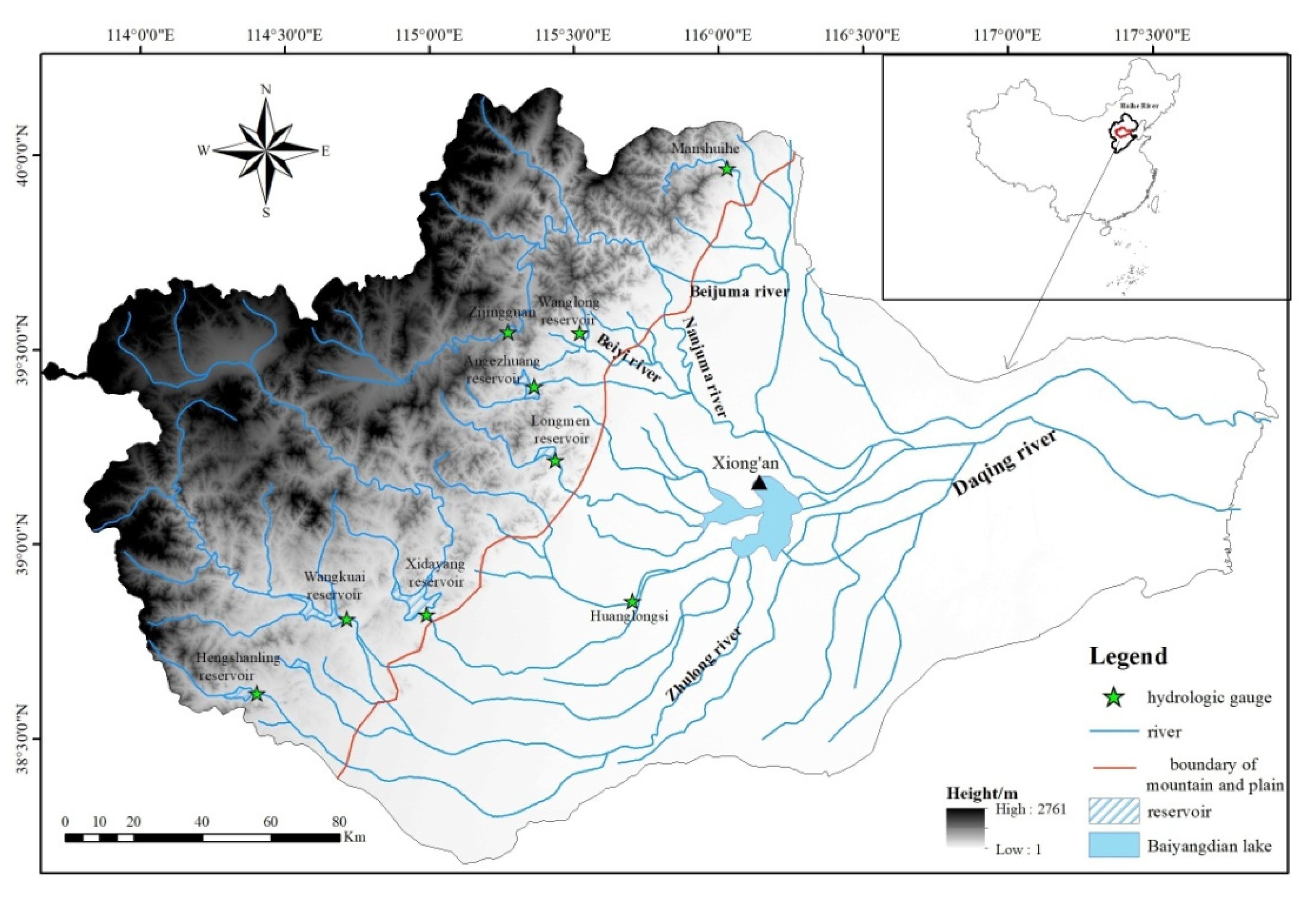
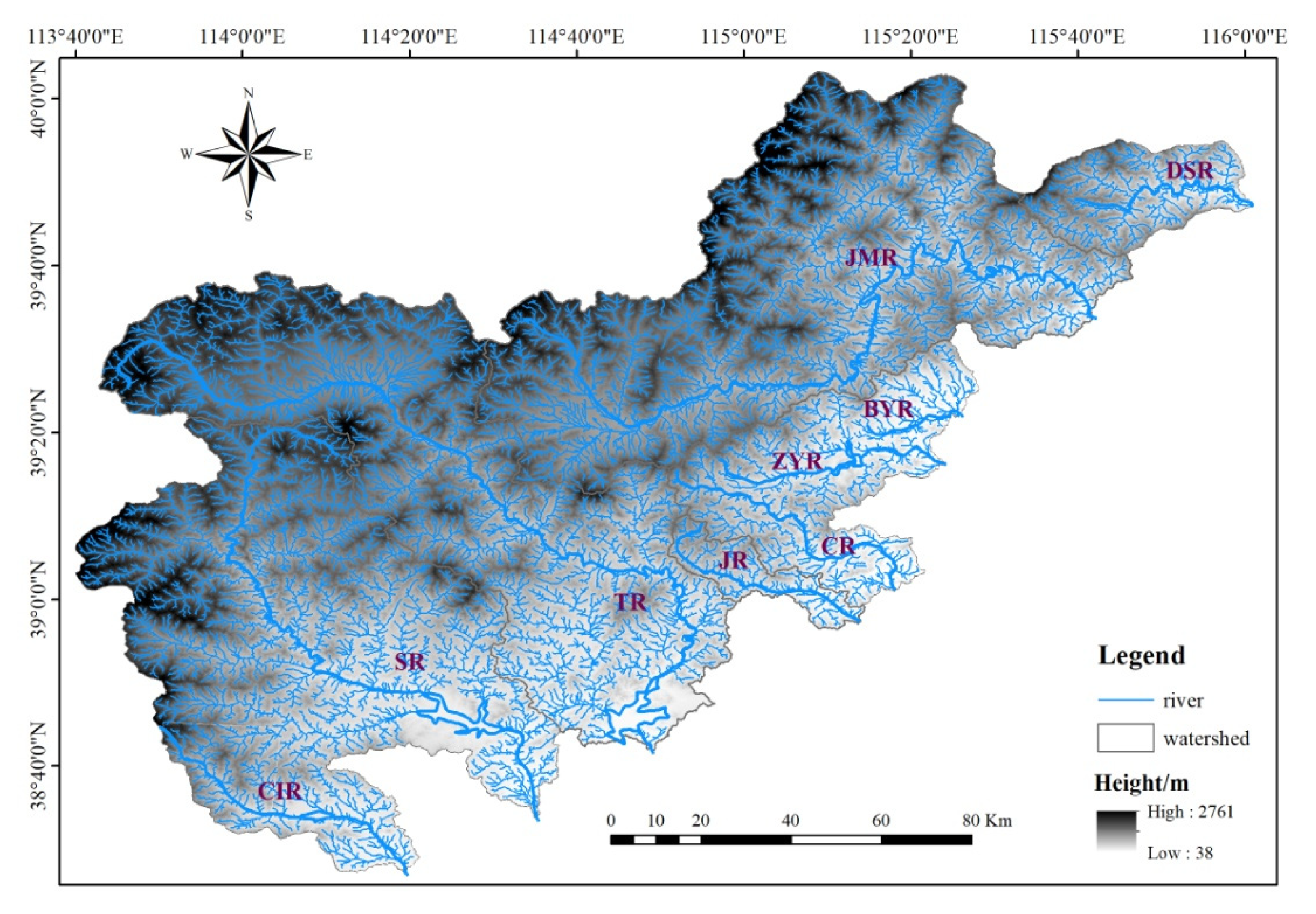
2. Study Area
3. Data description and Methods
3.1. Data
3.2. Method
3.2.1. The Extraction of River Networks
3.2.2. The Variables for Expressing Basin Form
3.2.3. Topographical Attributes
3.2.4. Hypsometric Integral
3.2.5. Analysis of Drainage Density
4. Results and Discussion
4.1. Watershed Geometry
4.2. River Network Morphology
4.2.1. Stream Order
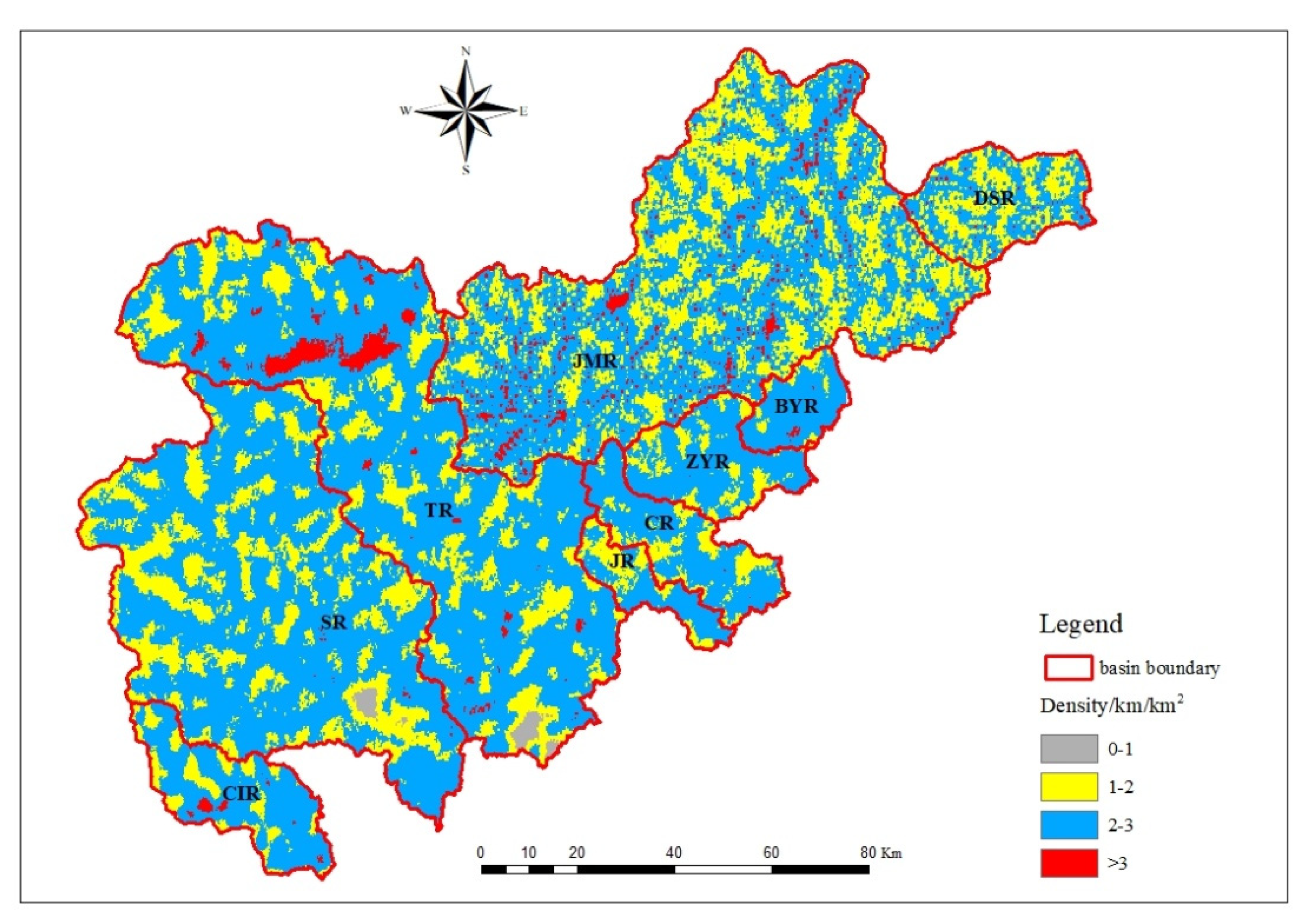
4.2.2. Drainage Density
4.3. Relationship between Dd and Rainfall and Vegetation Cover
4.4. Relationship between Dd and Soil Type
4.5. The Drainage Density and Terrain
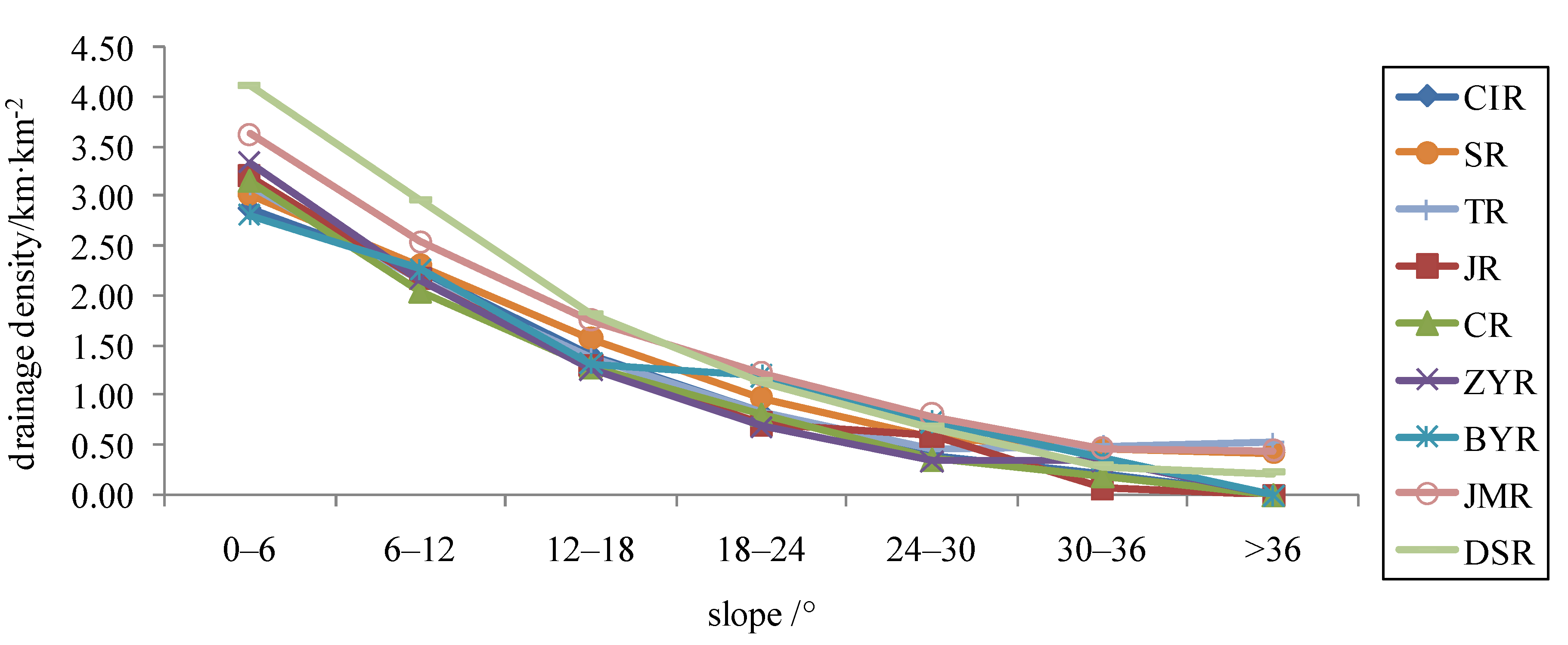
4.5.1. The Drainage Density on Different Slopes
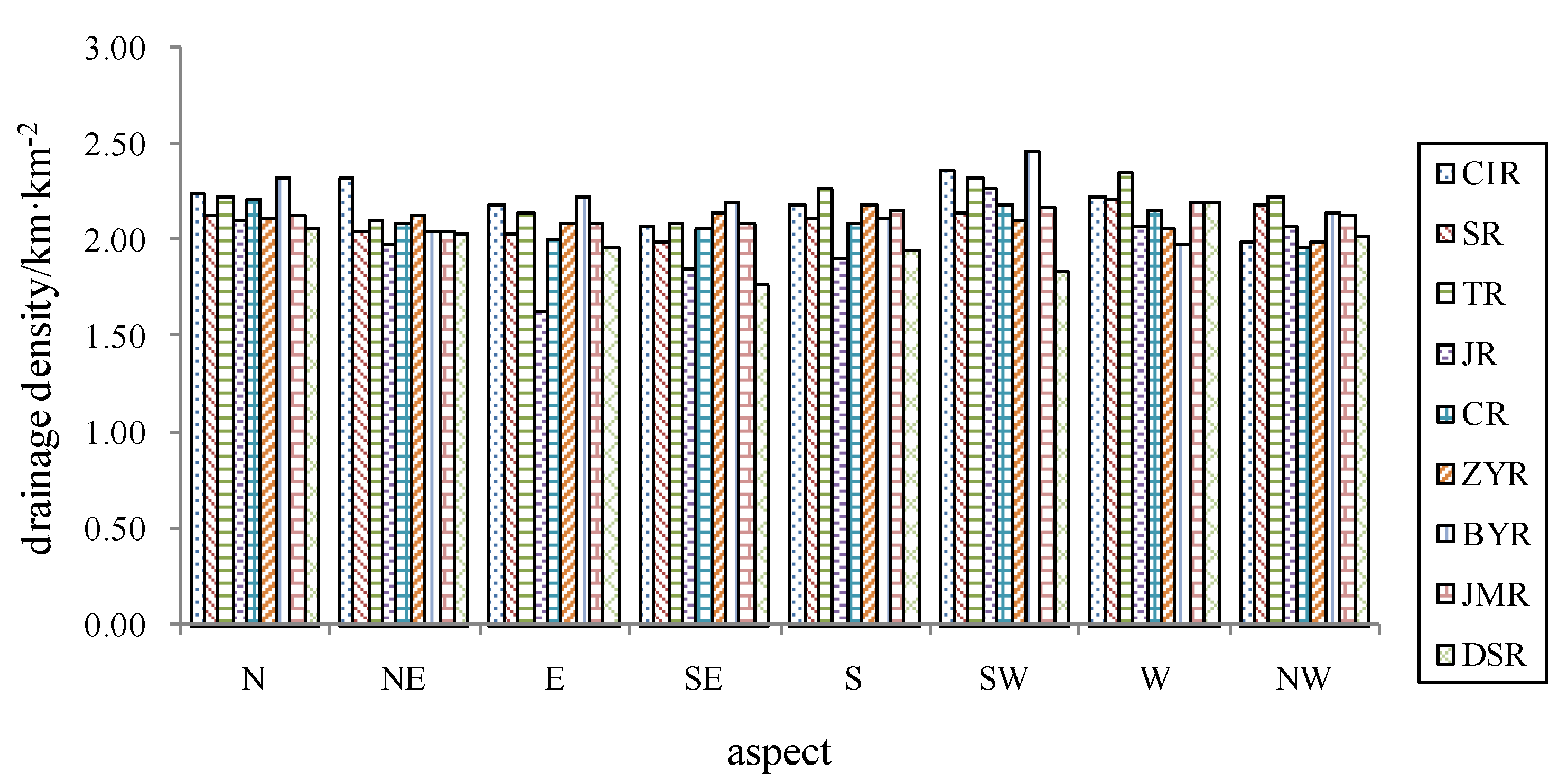
4.5.2. The Drainage Density in Different Aspect of Slopes
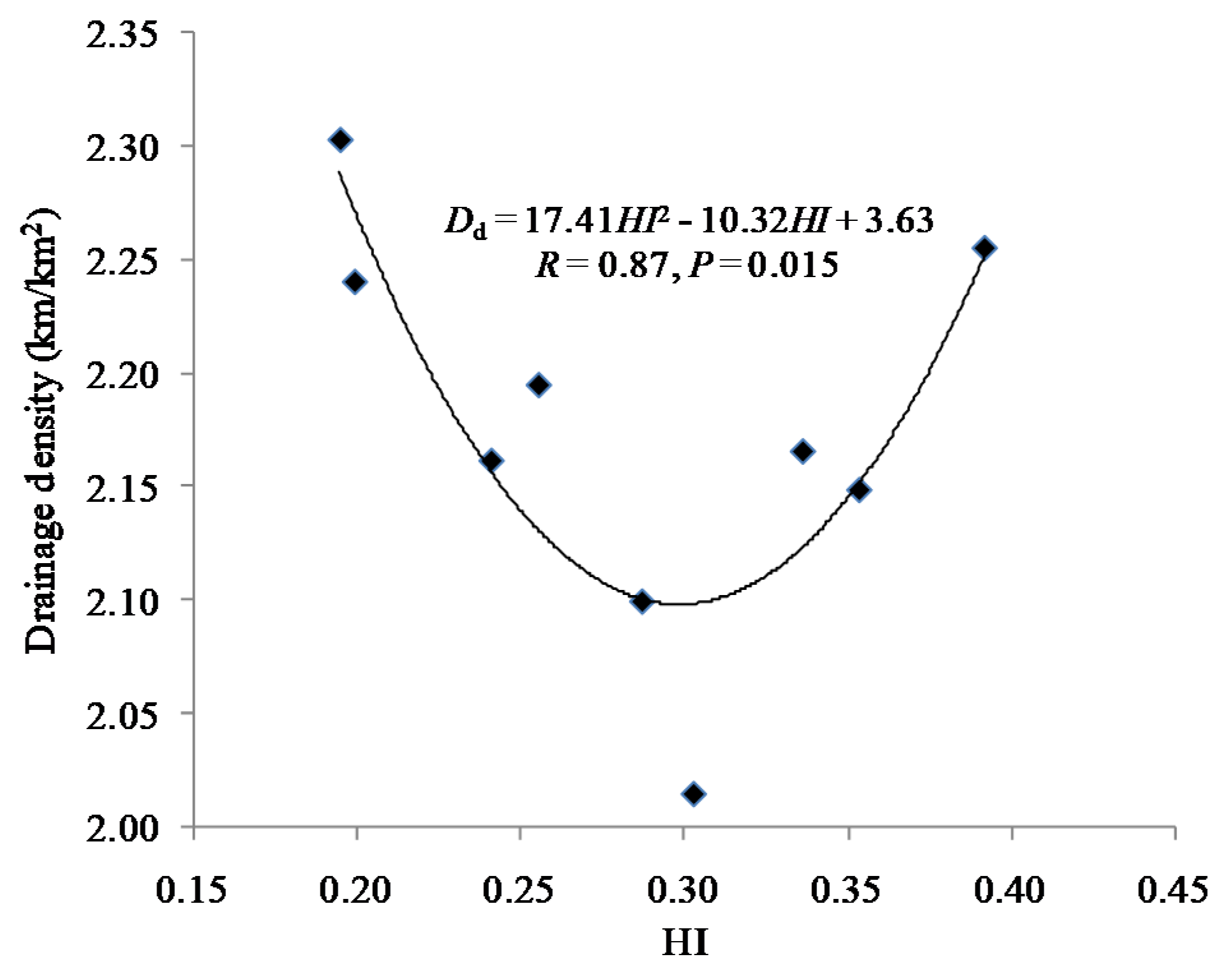
4.6. Indicative Significance of Dd
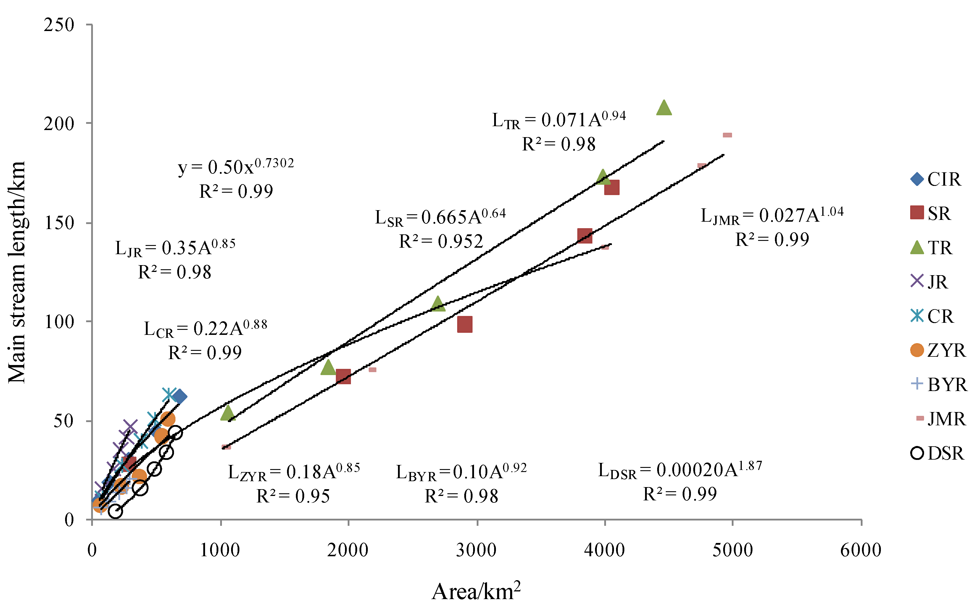
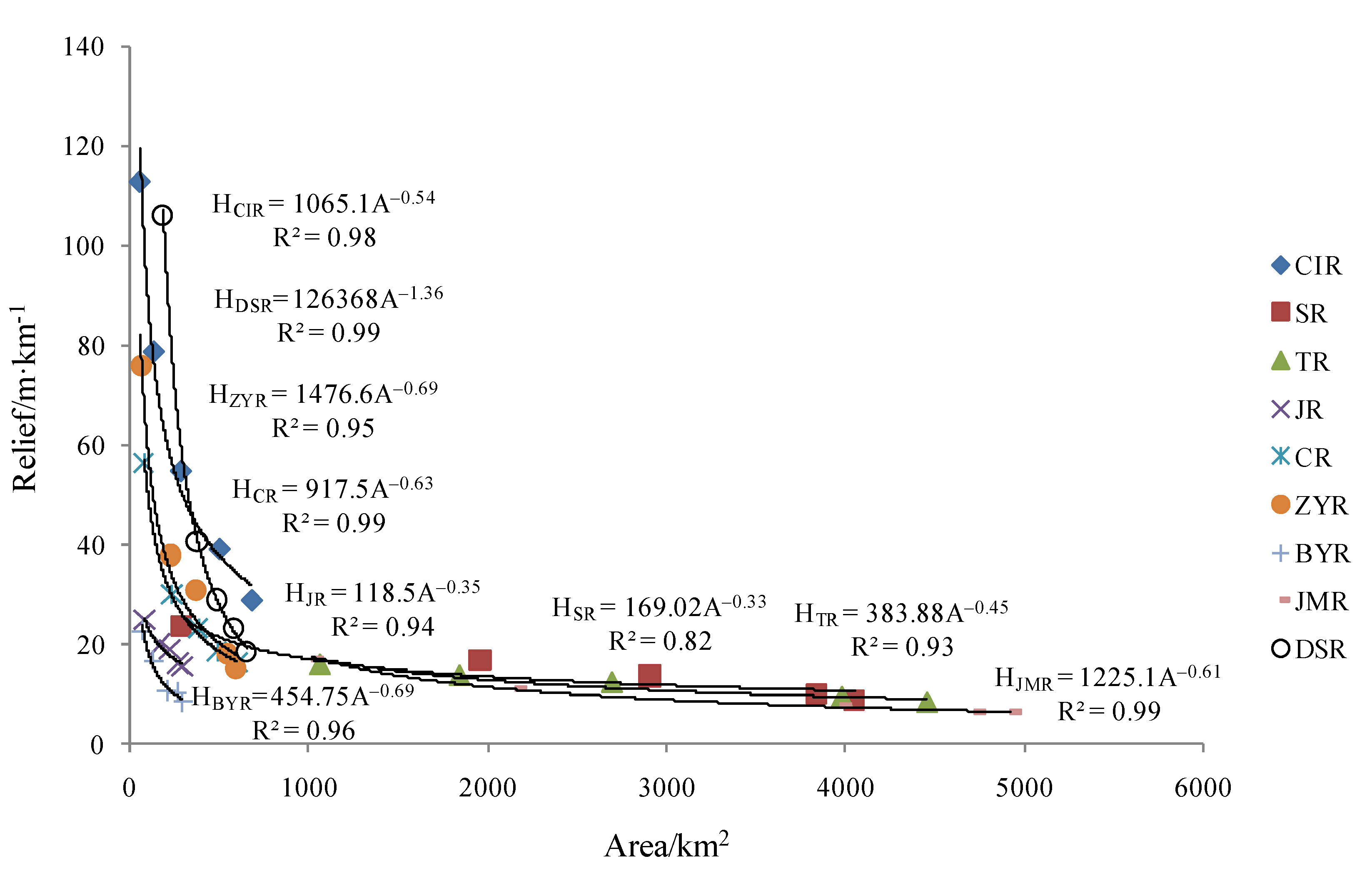
4.7. Effect of Channel Morphology on Water Yield
5. Conclusions
Author Contributions
Funding
Institutional Review Board Statement
Informed Consent Statement
Data Availability Statement
Acknowledgments
Conflicts of Interest
References
- Hynes, H.B. The Ecology of Running Waters; University of Toron to Press: Toronto, ON, Canada, 1970. [Google Scholar]
- Wohl, E.E. Mountain Rivers. Water Resources Monograph 14; American Geophysical Union: Washington, DC, USA, 2000. [Google Scholar]
- Chen, Q.; Guo, B.; Zhao, C.; Zhang, J. A comprehensive ecological management approach for northern mountain rivers in China. Chemosphere 2019, 234, 25–33. [Google Scholar] [CrossRef]
- Grant, G.E.; Swanson, F.J.; Wolman, M.G. Pattern and origin of stepped-bed morphology in high-gradient streams, Western Cascades, Oregon. Geol. Soc. Am. Bull. 1990, 102, 340–352. [Google Scholar] [CrossRef]
- Wohl, E.; Kuzma, J.N.; Brown, N.E. Reach-scale channel geometry of a mountain river. Earth Surf. Proc. Land. 2004, 29, 969–981. [Google Scholar] [CrossRef]
- Fryirs, K.; Brierley, G. Antecedent controls on river character and behaviour in partly confined valley settings: Upper hunter catchment, NSW, Australia. Geomorphology 2010, 117, 106–120. [Google Scholar] [CrossRef]
- Yadav, B.; Hatfield, K. Stream network conflation with topographic DEMs. Environ. Model. Softw. 2018, 102, 241–249. [Google Scholar] [CrossRef]
- Yang, H.; Shi, C. Basin form characteristics, causes and implications of the ten kongduis in the upper reaches of the Yellow River. Quat. Int. 2017, 453, 15–23. [Google Scholar] [CrossRef]
- Horton, R.E. Drainage-basin characteristics. Trans. Am. Geophys. Union 1932, 13, 350–361. [Google Scholar] [CrossRef]
- Passalacqua, P.; Do Trung, T.; Foufoula-Georgiou, E.; Sapiro, G.; Dietrich, W.E. A geometric framework for channel network extraction from lidar: Nonlinear diffusion and geodesic paths. J. Geophys. Res. Earth Surf. 2010, 115, F01002. [Google Scholar] [CrossRef] [Green Version]
- Pelletier, J.D. A robust, two-parameter method for the extraction of drainage networks from high-resolution digital elevation models (DEMs): Evaluation using synthetic and real-world DEMs. Water Resour. Res. 2013, 49, 75–89. [Google Scholar] [CrossRef]
- Clubb, F.J.; Mudd, S.M.; Milodowski, D.T.; Hurst, M.D.; Slater, L.J. Objective extraction of channel heads from high-resolution topographic data. Water Resour. Res. 2014, 50, 4283–4304. [Google Scholar] [CrossRef] [Green Version]
- Byun, J.; Seong, Y.B. An algorithm to extract more accurate stream longitudinal profiles from unfilled DEMs. Geomorphology 2015, 242, 38–48. [Google Scholar] [CrossRef]
- Rinaldo, A.; Gatto, M.; Rodriguez-Iturbe, I. River networks as ecological corridors: A coherent ecohydrological perspective. Adv. Water Resour. 2017, 112, 27–58. [Google Scholar] [CrossRef] [PubMed]
- Zhu, G.P.; Wang, X.R.; Wang, M.; Qi, S.; Gao, J.R. Advances on near natural comprehensive control of urban river. Sci. Soil Water Conserv. 2006, 4, 92–97. [Google Scholar]
- Mikus, P.; Wyzga, B.; Walusiak, E.; Radecki-Pawlik, A.; Liro, M.; Hajdukiewicz, H.; Zawiejska, J. Island development in amountain river subjected to passive restoration: The Raba River, Polish Carpathians. Sci. Total Environ. 2019, 660, 406–420. [Google Scholar] [CrossRef] [PubMed]
- Kuemmelen, M.; Reichert, P.; Siber, R.; Schuwirth, N. Ecological assessment of river networks: From reach to catchment scale. Sci. Total Environ. 2019, 650, 1613–1627. [Google Scholar] [CrossRef] [PubMed]
- Prodanovic, P.; Simonovic, S.P. An operational model for support of integrated watershed management. Water Resour. Manag. 2010, 24, 1161–1194. [Google Scholar] [CrossRef]
- Song, C.; Ke, L.; Pan, H.; Zhan, S.; Liu, K.; Ma, R. Long-term surface water changes and driving cause in Xiong’an, China: From dense Landsat time series images and synthetic analysis. Sci. Bull. 2018, 63, 708–716. [Google Scholar] [CrossRef] [Green Version]
- Cui, B.; Li, X.; Zhang, K. Classification of hydrological conditions to assess water allocation schemes for Lake Baiyangdian in North China. J. Hydrol. 2010, 385, 247–256. [Google Scholar] [CrossRef]
- Yang, Z.; Mao, X. Wetland system network analysis for environmental flow allocations in the Baiyangdian Basin, China. Ecol. Model. 2011, 222, 3785–3794. [Google Scholar] [CrossRef]
- Wang, X.L.; Zhang, Y. Current state of water environment of Daqing River basin and countermeasures. Water Resour. Prot. 2000, 2, 33–35, (In Chinese with English abstract). [Google Scholar]
- Tian, J.; Liu, J.; Wang, J.; Li, C.; Yu, F.; Chu, Z. A spatio-temporal evaluation of the WRF physical parameterisations for numerical rainfall simulation in semi-humid and semi-arid catchments of Northern China. Atmos. Res. 2017, 191, 141–155. [Google Scholar] [CrossRef]
- Xia, J.; Zhang, Y.Y. Water resource and pollution safeguard for Xiongan New Area construction and its sustainable development. Bull. Chin. Acad. Sci. 2017, 11, 1199–1205. [Google Scholar]
- Lu, L.; Yu, Y.D.; Liu, J.H.; Qin, D.Y. Analysis of hydrologic characteristics in Haihe River Basin. Haihe River Water Conserv. 2011, 6, 1–4. (In Chinese) [Google Scholar]
- Liu, W.J.; Zhao, Z.J. Analysis of the influence of the change of hydrological characteristics of Daqing he river basin on Baiyangdian wetland. Groundwater 2012, 34, 101–102. (In Chinese) [Google Scholar]
- Yan, Y.X.; Wang, S.J.; Yan, M.; He, L.; Cheng, D.S. Spatial patterns of scale effect of specific sediment yield in Haihe River Basin. Prog. Geogr. 2014, 33, 57–64, (In Chinese with English abstract). [Google Scholar]
- Yuan, Z.J.; Sun, Q. Runoff-sediment relationship for various spatial scales in the Daqing he rocky mountainous area. Resour. Sci. 2016, 38, 750–757, (In Chinese with English abstract). [Google Scholar]
- SL665-2014. Technical Standards for Comprehensive Treatment of Water and Soil Erosion in the Earth Rock Mountain Areas of Northern China; China Water Power Press: Beijng, China, 2014.
- Whipple, K.X.; Tucker, G.E. Dynamics of the stream-power river incision model: Implications for height limits of mountain ranges, landscape response time scales, and research needs. J. Geophys. Res. 1999, 104, 17661–17674. [Google Scholar] [CrossRef]
- Chen, Y.Z.; Jing, K.; Cai, Q.G. Modern Erosion and Control in the Loess Plateau; Science Press: Beijing, China, 1988. (In Chinese) [Google Scholar]
- Miller, V.C. A Quantitative Geomorphic Study of Drainage Basin Characteristics in Clinch Mountain Area, Virginia and Tennessee; Project NR 389-042, Tech. Rept. 3; Columbia University Department of Geology, O.N.R. Geography Branch: New York, NY, USA, 1953. [Google Scholar]
- Schumm, S.A. Evolution of drainage systems and slopes in badlands at Perth Amboy, New Jersey. Geol. Soc. Am. Bull. 1956, 67, 597–646. [Google Scholar] [CrossRef]
- Burrough, P.A.; McDonnell, R.A. Principles of Geographical Information Systems; Oxford University Press: Oxford, UK, 1998. [Google Scholar]
- Strahler, A.N. Hypsometric (area-altitude) analysis of erosional topography. Geol. Soc. Am. Bull. 1952, 63, 1117–1142. [Google Scholar] [CrossRef]
- Moglen, G.E.; Eltahir, E.A.B.; Bras, R.L. On the sensitivity of drainage density to climate change. Water Resour. Res. 1998, 34, 855–862. [Google Scholar] [CrossRef] [Green Version]
- Talling, P.J.; Sowter, M.J. Drainage density on progressively tilted surfaces with different gradients, wheeler ridge, california. Earth Surf. Process. Landf. 1999, 24, 809–824. [Google Scholar] [CrossRef]
- Tucker, G.E.; Bras, R.L. Hillslope processes, drainage density, and lands cape morphology. Water Resour. Res. 1998, 36, 1953–1964. [Google Scholar] [CrossRef]
- Luoto, M. New insights into factors controlling drainage density in subarctic landscapes. Arctic. Antarct. Alpine Res. 2007, 39, 117–126. [Google Scholar] [CrossRef] [Green Version]
- Collins, D.B.G.; Bras, R.L. Climatic and ecological controls of equilibrium drainage density, relief, and channel concavity in dry lands. Water Resour. Res. 2010, 46, W04508. [Google Scholar] [CrossRef] [Green Version]
- Smith, V.B.; David, C.H.; Cardenas, M.B.; Yang, Z.-L. Climate, river network, and vegetation cover relationships across a climate gradient and their potentialfor predicting effects of decadal-scale climate change. J. Hydrol. 2013, 488, 101–109. [Google Scholar] [CrossRef]
- Chaick, O.A.; Roering, J.J.; Heimsath, A.M.; Levick, S.R.; Asner, G.P.; Khomo, L. Shaping post-orogenicl and scapes by climate and chemical weathering. Geology 2013, 41, 1171–1174. [Google Scholar] [CrossRef] [Green Version]
- Strahler, A.N. Statistical Analysis in Geomorphic Research. J. Geol. 1954, 62, 1–25. [Google Scholar] [CrossRef]
- Chien, N.; Zhang, R.; Zhou, Z.D. Fluvial Processes Study; Science Press: Beijing, China, 1987. [Google Scholar]
- Liu, R.L. The Characteristics of Water Network and Landforms of the Beisha River in Taishan Mountain; Shandong Normal University: Jinan, China, 2011; (In Chinese with English abstract). [Google Scholar]
- Hoton, R.E. Erosional development of stream sand their drainage basins; hydrophysical approach to quantitative morphology. GSA Bull. 1945, 56, 275–370. [Google Scholar] [CrossRef] [Green Version]
- Morisawa, M.E. Quantitative geomorphology of some watersheds in the Appalachian Plateau. Geol. Soc. Am. Bull. 1962, 73, 1025–1046. [Google Scholar] [CrossRef]
- Sangireddy, H.; Carothers, R.A.; Stark, C.P.; Passalacqua, P. Controls of climate, topography, vegetation, and lithology on drain age density extracted from high resolution to pography data. J. Hydrol. 2016, 537, 271–282. [Google Scholar] [CrossRef] [Green Version]
- Wu, Q.F.; Zhang, H.J. Soil Erosion; Science Press: Beijing, China, 2012. [Google Scholar]
- Meton, M.A. An Analysis of the Relations Among Elements of Climate, Surface Properties, and Geomorphology; Technical Report 11; Office of Naval Research, Department of Geology, Columbia University: New York, NY, USA, 1957. [Google Scholar]
- Ochi, T. Drainage density and relative relief in humid steep mountains with frequent slope failure. Earth Surf. Process. Landf. 1997, 22, 107–120. [Google Scholar] [CrossRef]
- Chen, H.; Fang, H.Y.; Cai, Q.G.; Lei, T.W.; Liang, G.L. Comparison of different aspect of erosion evolvement in the loess hilly area: A case study of Wangjiagou Rinaldo catchment of western Shanxi province. Resour. Sci. 2006, 28, 176–184, (In Chinese with English abstract). [Google Scholar]


| Parameters | Symbol and Definition | Unit | Reference |
|---|---|---|---|
| Drainage area | A | km2 | |
| Main stream length | L | km | |
| Drainage perimeter | P | km | |
| Circularity ratio | Rc = 4πA/P2 | / | [32] |
| Elongation ratio | Re = 2(A/π)1/2/L | / | [33] |
| Relief | H | m/km | |
| Total stream length | ∑L | km | |
| Drainage density | Dd = ∑L/A | km/km2 | [9] |
Publisher’s Note: MDPI stays neutral with regard to jurisdictional claims in published maps and institutional affiliations. |
© 2021 by the authors. Licensee MDPI, Basel, Switzerland. This article is an open access article distributed under the terms and conditions of the Creative Commons Attribution (CC BY) license (https://creativecommons.org/licenses/by/4.0/).
Share and Cite
Yang, H.; Cao, J. Analysis of Basin Morphologic Characteristics and Their Influence on the Water Yield of Mountain Watersheds Upstream of the Xiongan New Area, North China. Water 2021, 13, 2903. https://doi.org/10.3390/w13202903
Yang H, Cao J. Analysis of Basin Morphologic Characteristics and Their Influence on the Water Yield of Mountain Watersheds Upstream of the Xiongan New Area, North China. Water. 2021; 13(20):2903. https://doi.org/10.3390/w13202903
Chicago/Turabian StyleYang, Hui, and Jiansheng Cao. 2021. "Analysis of Basin Morphologic Characteristics and Their Influence on the Water Yield of Mountain Watersheds Upstream of the Xiongan New Area, North China" Water 13, no. 20: 2903. https://doi.org/10.3390/w13202903
APA StyleYang, H., & Cao, J. (2021). Analysis of Basin Morphologic Characteristics and Their Influence on the Water Yield of Mountain Watersheds Upstream of the Xiongan New Area, North China. Water, 13(20), 2903. https://doi.org/10.3390/w13202903