Article

The Development Trend and Research Frontiers of Distributed Hydrological Models—Visual Bibliometric Analysis Based on Citespace

1
College of Water Resources & Hydropower, Sichuan University, Chengdu 610065, China
2
State Key Laboratory of Hydraulic and Mountain River Engineering, Sichuan University, Chengdu 610065, China
3
Heavy Rain and Drought-Flood Disasters in Plateau and Basin Key Laboratory of Sichuan Province, Chengdu 610072, China
*
Authors to whom correspondence should be addressed.
Water 2021, 13(2), 174; https://doi.org/10.3390/w13020174
Submission received: 21 November 2020 / Revised: 6 January 2021 / Accepted: 9 January 2021 / Published: 13 January 2021

Abstract

:
Based on the bibliometric and data visualization analysis software Citespace, this study carried out document statistics and information mining on the Web of Science database and characterized the distributed hydrological model knowledge system from 1986 to 2019. The results show a few things: (1) from 1986 to 2019, the United States and China accounted for 41% of the total amount of publications, and they were the main force in the field of distributed hydrological model research; (2) field research involves multiple disciplines, mainly covering water resources, geology, earth sciences, environmental sciences, ecology and engineering; (3) the frontier of field research has shifted from using distributed hydrological models in order to simulate runoff and nonpoint source environmental responses to the coupling of technologies and products that can obtain high-precision, high-resolution data with distributed hydrological models. (4) Affected by climate warming, the melting of glaciers has accelerated, and the spatial distribution of permafrost and water resources have changed, which has caused a non-negligible impact on the hydrological process. Therefore, the development of distributed hydrological models suitable for alpine regions and the response of hydrological processes to climate change have also become important research directions at present.

1. Introduction

Water resources are important natural resources that maintain ecological balance and promote the economic development of modern society. In the past two decades, the emergence of problems such as population expansion, water shortage, environmental pollution and climate change [1,2,3] have made rational planning of water-resource allocation and sustainable use of water resources become a top priority. Driven by research needs, the development and application of distributed hydrological models has also become a hot spot in the field of hydrological research.
The distributed hydrological model is an important tool for understanding the hydrological cycle and planning the sustainable use of water resources to meet various needs [4]. Currently, distributed hydrological models are widely used to the major scientific issues like the hydrological response under climate change [5,6], nonpoint source pollution [7], integrated water resources management [8], hydrological response to land use/cover change [9], etc. In addition to applying models to solve problems, research in the field of distributed hydrological models also includes the development, continuous updating and improvement of many models, as well as coupling with other technologies or products (such as GIS, remote sensing technology, precipitation products, etc.) [10,11,12,13] to obtain more accurate simulation results. It can be seen that the research field of distributed hydrological model research is multifaceted.
The focus of scientific research changes over time. In a complex research field, it is difficult for many scholars to directly understand the overall knowledge structure of the field, research progress, research frontiers and hot spots and so on. This study was based on a visual analysis software—Citespace. It describes the core research strength, development trajectory, research frontiers and emerging trends in the field of distributed hydrological model research through statistical analysis of 3079 documents using scientometrics. The results will provide valuable reference information for scholars and related researchers.

2. Data Collection and Method

2.1. Data Collection

The documents for analysis used in this study were derived from the SCI-E database, the core collection of Web of Science. The search conditions were “Distributed Hydrological Model”, “Not Semi-distributed Hydrological Model”, and “And article”, and the time span was 1920–2019 by basic search. Under such search conditions, a total of 3079 documents were retrieved. The searched documents first appeared in 1986; therefore, the time span of the retrieved documents was from 1986 to 2019, and 3079 documents remained after deduplication. In addition, because the relevant data of the documents published in 2020 is not complete, this article separately analyzes the keyword co-occurrence of 226 documents with a time span from January 2020 to October 2020.

2.2. Method

Bibliometrics is a branch of informatics used to analyze quantitative scientific documents to be able to see the knowledge structure of the field and emerging research trends [14]. As a software for bibliometrics visualization and analysis, Citespace was developed based on Java by Dr. Chen Chaomei from Drexel University. Citespace is used to analyze the co-occurrence network of disciplines in the field, evaluate the research status and reveal the main research forces, research frontiers and emerging trends in the field [15,16,17]. So far, Citespace has been used in psychology [18], nonpoint source pollution research [19], stormwater management [20], information science [21] and other fields. This study used the 5.7.R1 version of Citespace to analyze 3079 documents retrieved in the field of distributed hydrological model research. The content of the analysis includes co-occurrence network analysis of country/region, institutional, co-citation analysis of author, document, keywords co-occurrence and burst word analysis. Network nodes used a single node. The nodes usually represent authors, countries, institutions, keywords, etc. Each node is described as a series of tree rings with different colors (corresponding to different years), and the surrounding purple rings indicate good concentration: the higher the citation and centrality of a node, the greater the influence of the node in the co-citation map [22]. The link represents the common reference or common occurrence between these nodes, and the color of the link represents the year when the two nodes co-occur [23]. The time slice in this study was one year, and the data selection criterion was the top 50.

3. Results and Discussion

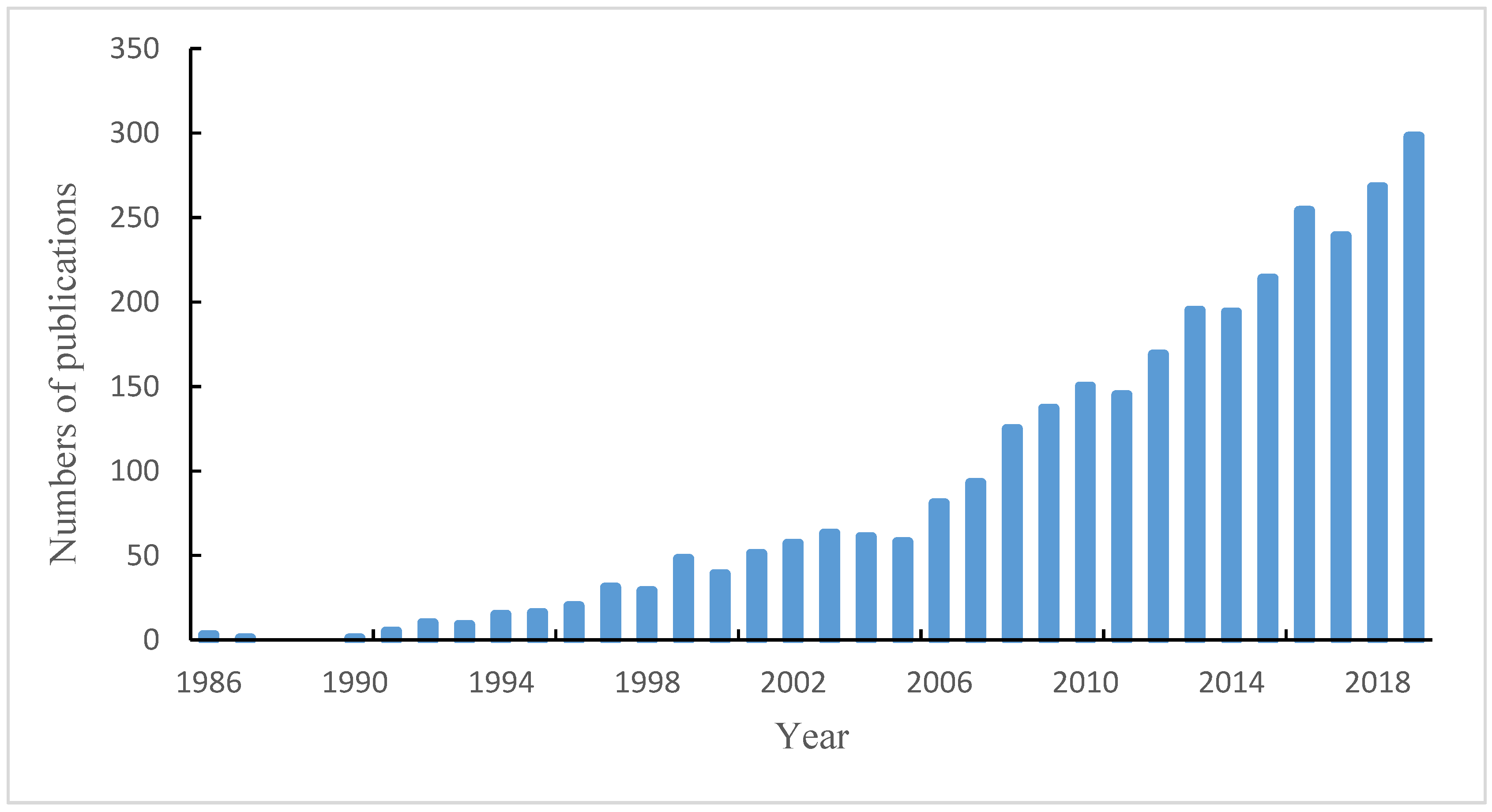
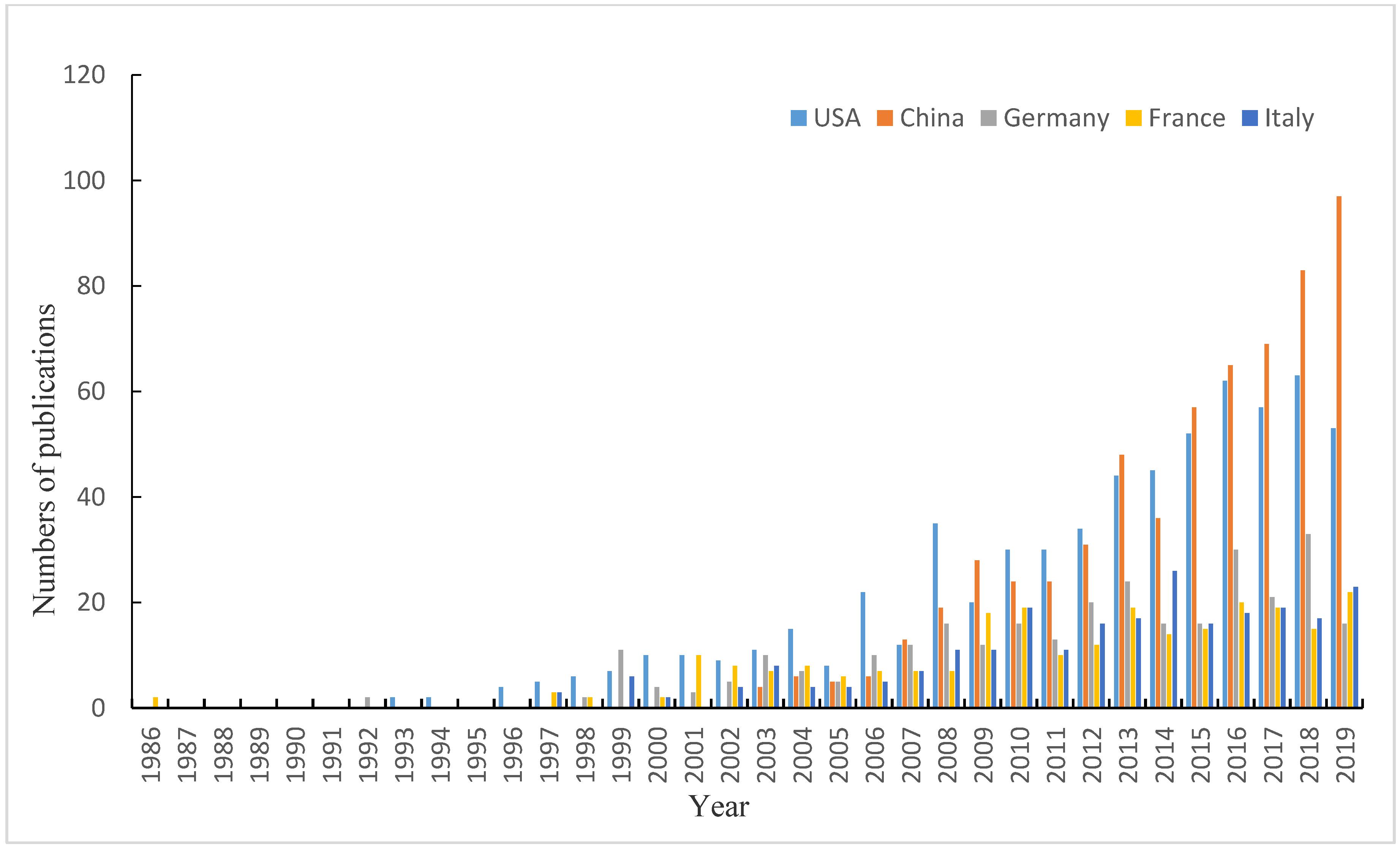
3.1. Time Analysis of Post Volume

In order to summarize the research situation of distributed hydrological models, this article counted the circulation of documents related to distributed hydrological models in the core collection of Web of Science from 1986 to 2019 (Figure 1). The total number of documents was 3079. Around the 1990s, a number of distributed hydrological models emerged in the context of the promotion of research needs such as the sustainable use of water resources, nonpoint source pollution, the impact of global changes on the hydrological cycle and the rapid development of computer technology [24]. In 1986, three documents were published, two of which were introductions of the SHE model of the distributed water collection model system based on physics developed in Europe [25,26]. No related documents were published in the core collection of Web of Science in 1988 and 1989. From 1986 to 1993, no more than 10 documents were published each year. Since then, the number of annual publications had increased significantly, from 15 in 1994 to 298 in 2019. Distributed hydrological models have shown a significant increase overall since 1994, which means that scholars had been paying more and more attention to distributed hydrological models, that research investment had gradually increased since 1994, and that the field of distributed hydrological model shows a trend of rapid development. So far, distributed hydrological models have become an indispensable application tool in related research fields.

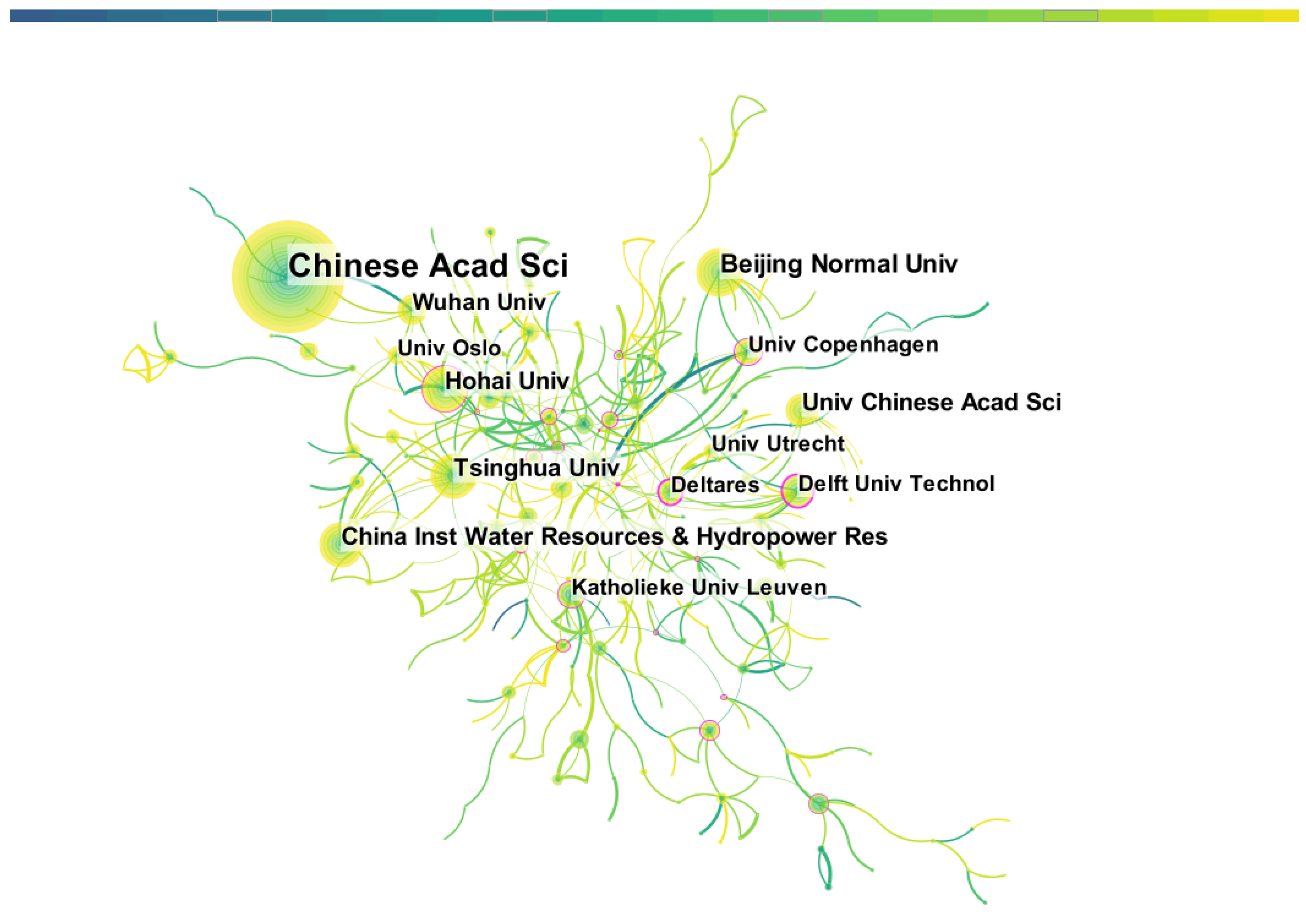
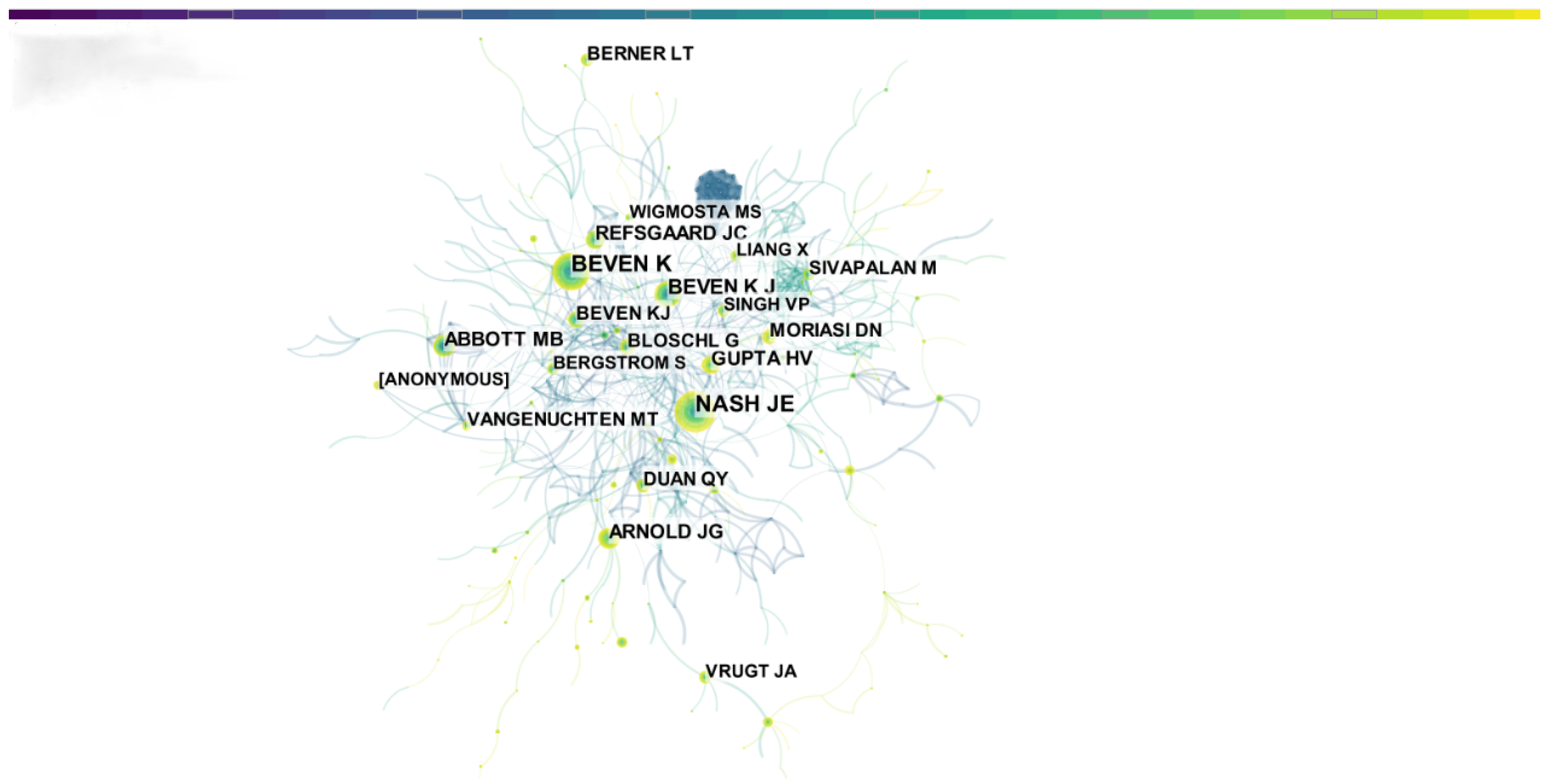
3.2. Cooperation Network Analysis

The analysis of cooperation networks in this article includes the analysis of cooperation networks between countries/regions and between institutions. The analysis of the cooperation network can reveal the cooperation network between the issuing countries and institutions and can explore the main research force of distributed hydrological models. It can also help different research units to establish cooperative relations. Running Citespace, we obtained a country/region cooperation network map with 59 nodes and 280 links (Figure 2) and an institution cooperation network map with 394 nodes and 775 links (Figure 3). A node in the figure represents a country/region (Figure 2) or research institution (Figure 3), that is, 59 countries and 394 institutions have published research results on this topic. The size of the node represents the amount of posts. The countries/regions and institutions connected by lines indicate cooperative relations, and the thickness of the line indicates the closeness of the partnership [27].
Research on distributed hydrological models was distributed in 59 countries/regions. Figure 2 shows that among 59 countries, the United States, China and some European countries (including Germany, France, Italy, England, Canada, The Netherlands, Australia, Switzerland, etc.) (top ten documents published) have more research on distributed hydrological models, which means the distributed hydrological models were widely used on a global scale. There were cooperative relations between multiple countries, among which China and France were the hubs of the cooperative network. The United States and China ranked first and second with 649 and 615 documents, respectively, accounting for 41% of the total number of documents. Therefore, the United States and China are the main research forces of distributed hydrological models. The top ten countries accounted for 96% of all publications, suggesting that these countries dominate the development of the field of distributed hydrological modeling.
The number of articles published in a country has a considerable relationship with the population base. The top 5 countries with the number of articles published are USA, China, Germany, France and Italy. The number of articles published in these five countries is related to the population (population quantity unit is one million). The ratios are 1.98, 0.44, 3.66, 3.76, 4.10, respectively, which shows that Italy has invested a lot in the field of distributed hydrological models, while the number of people active in the field of distributed hydrological models in China accounted for the total proportion is small. Figure 3 shows the changes in the number of posts issued by the top five countries from 1986 to 2019. Figure 3 shows the overall increase in the number of posts in these five countries. The annual number of articles published in the United States has accounted for a relatively large proportion for many years. China has only published a record of articles since 2003, but the growth trend has been the most obvious from 2003 to 2019.
Figure 4 shows that the Chinese Academy of Sciences, Beijing Normal University, Hohai University, China Institute of Water Resources and Hydropower Research and Tsinghua University have more research results. The top ten institutions in terms of publication volume are listed in Table 1, and seven of them are Chinese institutions. It shows that China has invested more in the research of distributed hydrological models. However, the cooperation of the seven Chinese institutions is not very close. Among them, only the Chinese Academy of Sciences and Wuhan University, as well as the China Institute of Water Resources and Hydropower Research and Tsinghua University have a cooperative relationship. On the whole, the top ten institutions have few exchanges and little cooperation, so it is necessary to strengthen China’s domestic and international cooperation.

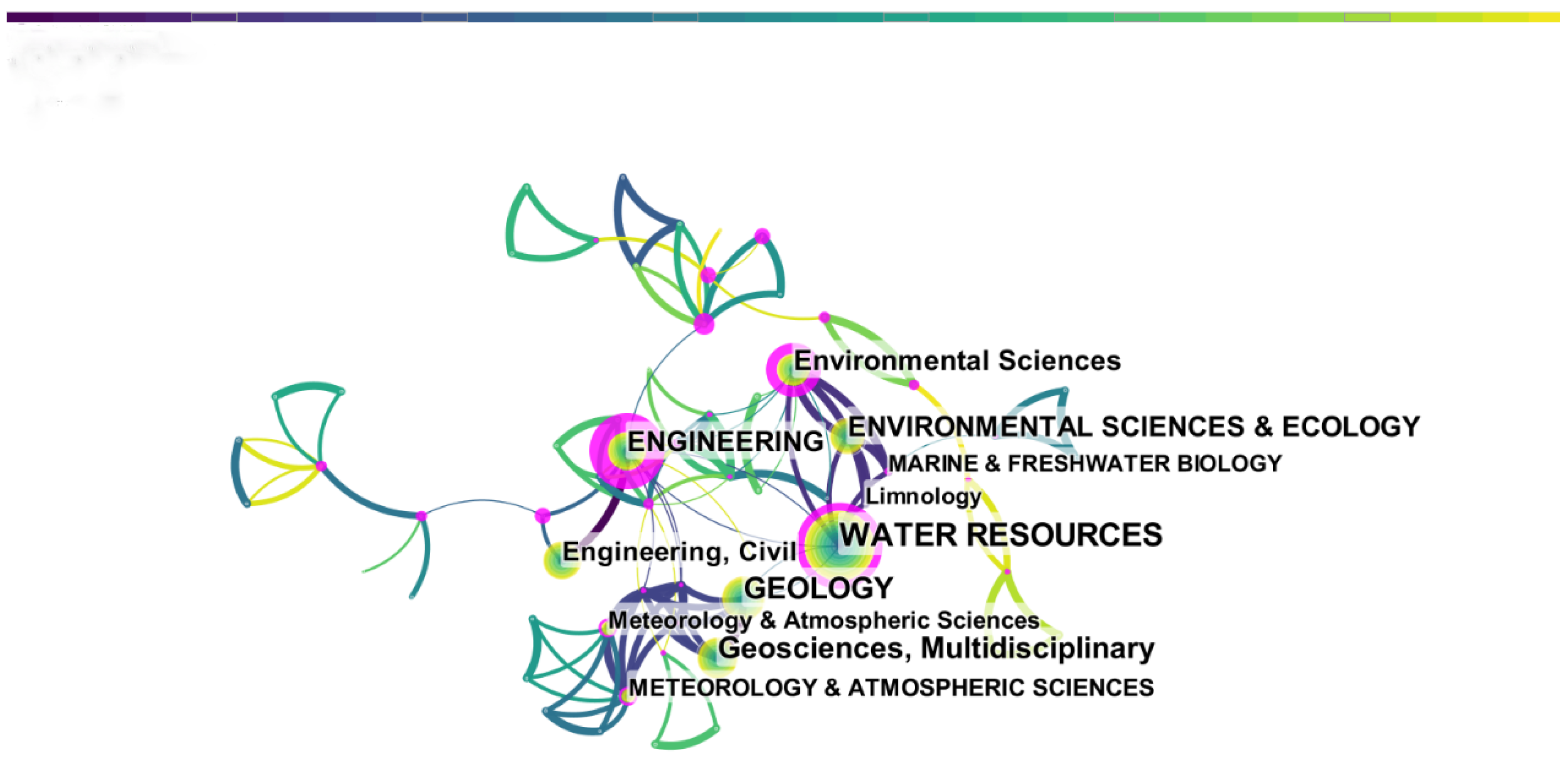
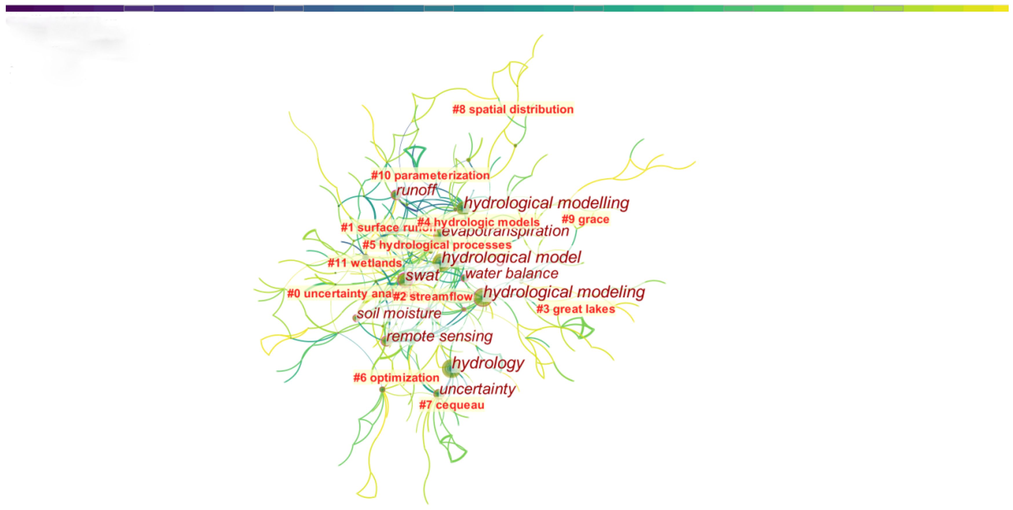
3.3. Co-Occurrence of Discipline Categories

Based on the co-occurrence analysis of discipline categories, disciplines involving distributed hydrological models can be detected, running Citespace to get 65 nodes and 255 links. A node represents a discipline category. The link linking two nodes means the co-occurrence of two discipline categories. It can be seen from Figure 5 that the research and application of distributed hydrological models involve multiple discipline categories. Figure 4 shows eleven disciplines. The top five popular research disciplines are water resources, geology, earth science, engineering and environmental science and ecology. In the field of water resources, distributed hydrological models were used to calculate snowmelt [28], evaluate water quality [4,29], observe and simulate changes in river flow [30] and flood forecasting [31], etc., to realize the rational allocation and sustainable use of water resources. When the research area is located in a mountainous area, it is necessary to use the knowledge of geology, earth science and engineering to explore the influence of the topography in the complex mountain on the hydrological process [28,32]. This shows that there is a phenomenon of multidisciplinary integration in the field of distributed hydrological models.

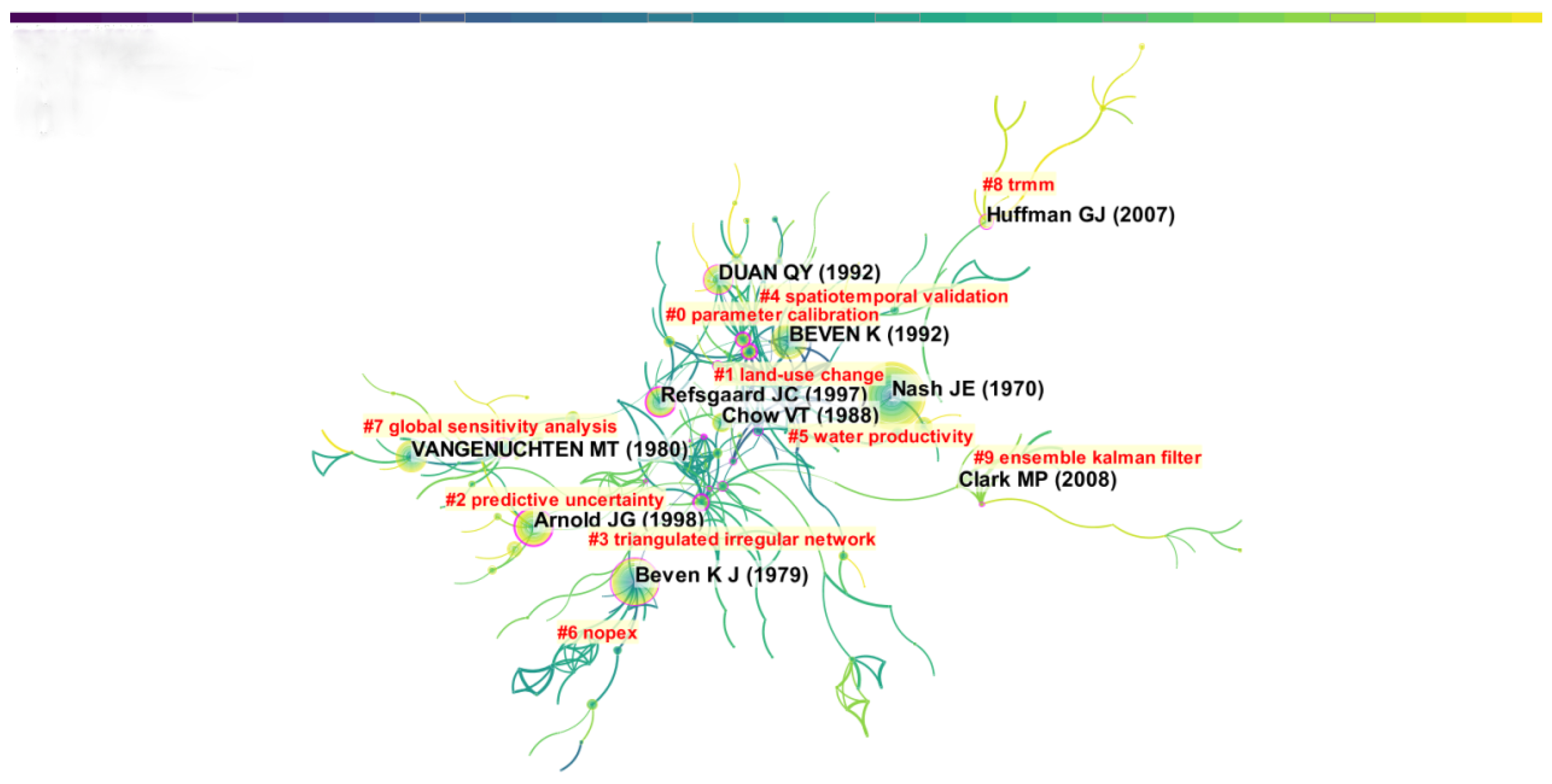
3.4. Co-Citation Analysis

Co-citation analysis includes author co-citation analysis and document co-citation analysis, which means that two authors or two documents are cited by a third party at the same time. The concept of author co-citation was first proposed by White and McCain [33]; it reflects the proximity of research directions and the importance of the author and has been widely used to assess the relevance of scientific research. High-frequency co-cited documents usually have breakthroughs and innovations in the corresponding research areas; at the same time, high-frequency co-cited references form the knowledge base of the current analyzed field, which is of great significance to the development of the field.
Figure 6 shows the author co-citation map created by Citespace, with a total of 582 nodes, and each node represents a cited author. The author of the largest node in the figure was BEVEN K, whose documents have been cited 1241 times, as well as NASH JE (777), ARNOLD JG (338), ABBOTT MB (269), REFSGAARD JC (261), GUPTA HV (245), MORIASI DN (230), DUAN QY (217), BERNER LT (199), BLOSCHL G (196) and others. They represent the core people in the research and development of distributed hydrological models.
Running Citespace to analyze the co-cited references, we obtained 484 nodes and 1526 links. The references co-citation map is shown in Figure 7. The co-cited references were clustered and analyzed. The top ten major clusters in terms of size are listed in Table 2. The size value indicates the size of the cluster. The larger the size, the greater the number of related documents published in the cluster, and large clusters usually represent the main research direction, that is, one cluster corresponds to one research hotspot. The silhouette value reflects the similarity of the clusters; the closer its value is to 1, the better the quality of the cluster. The silhouette values of the clusters in Table 2 are all close to 1, indicating that all the clusters are highly uniform. Mean year represents the average year of documents publication in the cluster. The larger the value, the newer the mean year of the publication in the cluster and the closer to the current research frontier. The most representative term in each cluster was detected and selected by Logarithmic Likelihood Ratio (LLR), which is used to mark corresponding cluster for discussion. In the top ten clusters (Table 2), the mean years ≥ 2005 were #8 (2009) and #9 (2006). The representative terms were TRMM and ensemble Kalman filter, respectively. The full name of TRMM is Tropical Rainfall Measuring Mission, which is a meteorological satellite developed by the National Aeronautics and Space Administration (NASA) and Japan Aeronautics and Space Administration (JAXA) to quantitatively measure tropical and subtropical rainfall [34]. Recently, ensemble Kalman filter has been used to solve in the inverse problem of water environment pollution source identification, effectively improving the efficiency of updating observations in the models [35].
Highly cited documents are usually groundbreaking in the research field and are of great significance to the development of the field. The top ten most highly cited documents in the field of distributed hydrological model research are listed in Table 3. The main content involved is as follows: (1) the proposed concepts, methods, technologies and application principles of distributed hydrological models (documents 1, 5, 6 and 8) [36,37,38,39]; (2) evaluation and improvement of distributed hydrological models (documents 2, 3 and 10) [40,41,42]. The distributed hydrological-vegetation model described in the second document considers the impact of canopy interception, evaporation and transpiration as well as snow cover and snowmelt on runoff [40], and the tenth document solves the problem of CRR (Conceptual Rainfall-Runoff) model optimization [42]; (3) the development and introduction of new models (documents 4, 7 and 9) [25,26,43], including the SWAT model [43] and the SHE model [25,26].

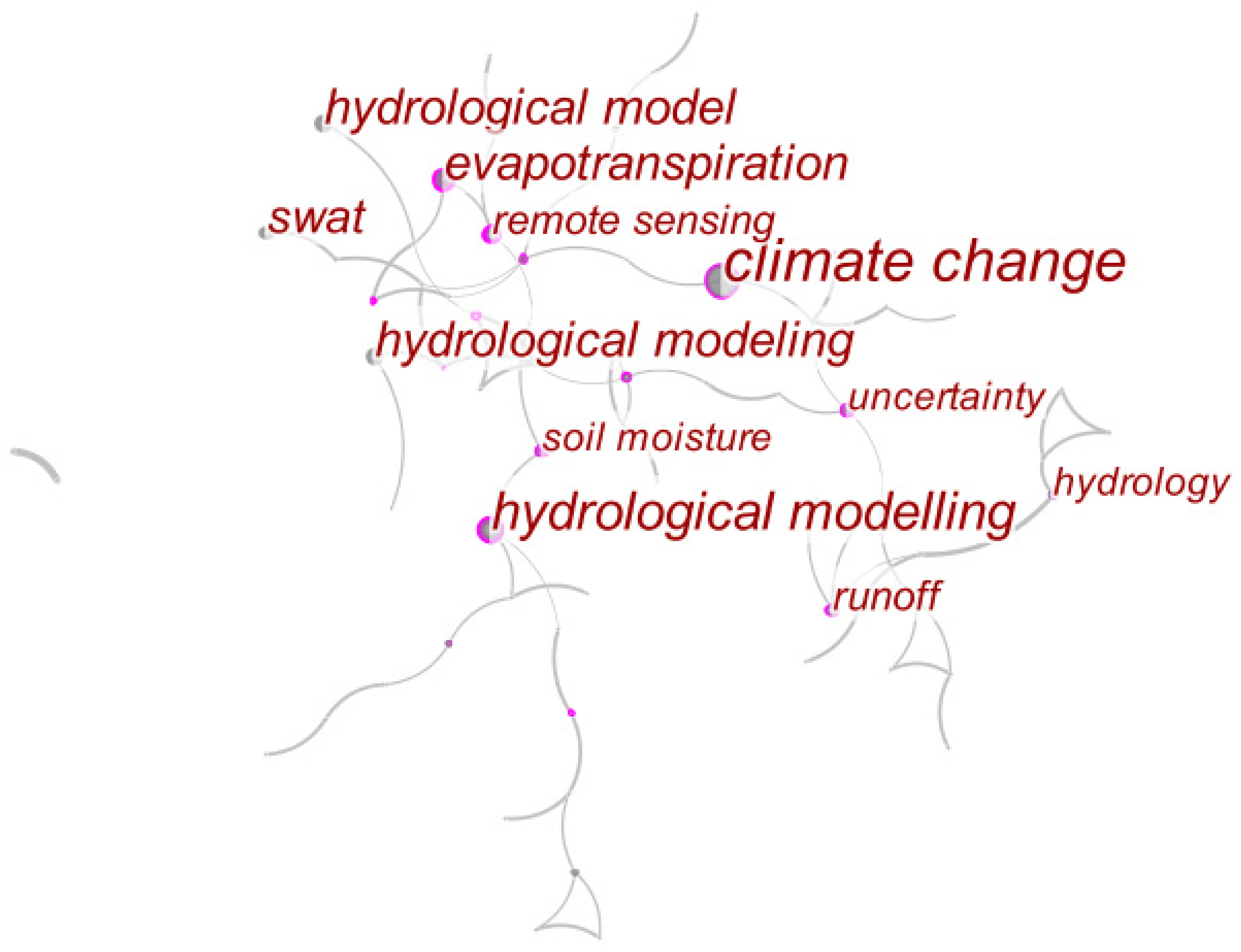
3.5. Keywords Co-Occurrence and Burst

Keywords can highly condense and summarize the research content of the documents, which is an effective method to determine the overall structure and research theme of a research field. The higher the frequency of the keywords, the more representative the research hotspots in the field. Running Citespace to get the keyword co-occurrence network, with a total of 398 nodes and 1138 links, we performed cluster analysis on the co-occurring keywords and obtained 18 clusters. The result is shown in Figure 8. The high-frequency keywords include “distributed hydrological model”, “climate change”, “SWAT”, “evapotranspiration”, “uncertainty”, “remote sensing”, “runoff”, “water balance”, “soil moisture”, “GIS”, etc., which represent the focus of research in the field. The top ten clusters of size were listed in Table 4. Cluster #7 “CEQUEAU” in Table 4 is a distributed deterministic hydrological model that takes into account the physical characteristics of the watershed as well as their space-domain variation, which developed by the Institut National de la Recherche Scientifique, Québec, Canada [44]. It can be seen from the average year that clusters #0 (uncertainty analysis), #3 (Great Lakes), #6 (optimization) and #9 (GRACE (Gravity Recovery and Climate Experiment)) are clusters formed in recent years, which means that the research hotspots in recent years include uncertainty analysis and optimization of the distributed hydrological model, combined with the time-varying gravity field provided by the GRACE gravity satellite to detect changes in surface water storage, and the application of the distributed hydrological model to evaluate the water storage, water quality and ecological environment of large lakes.
Citespace’s burst terms analysis function can be used to investigate terms that appear suddenly and have a rapid increase in frequency. Burst terms often reflect the research frontiers in the field. The top 52 burst terms in strength are listed in Table 5. According to the time axis in Table 5, the time of the appearance and disappearance of the research front can be judged, and the time axis can intuitively reflect the historical length of the mutation word outbreak. The statistical burst terms first appeared in 1995. The earliest research front was the application of distributed hydrological models to simulate runoff and nonpoint source environmental response. The TOPMODEL [45] was a model that scholars studied and used more in the early stage. The scale problems of distributed hydrological model modeling and the aggregation and disaggregation method in hydrological modeling have also attracted the attention of scholars [46]. In 1999, the impact of evapotranspiration on the surface water cycle process began to receive attention [47], and complex hydrological models for mountain basins were also developed [48]. From 2001 to 2005, the research front shifted to the sensitivity analysis of distributed hydrological model parameters and the automatic calibration of the models. At the same time, the integration of GIS technology with distributed hydrological models provides powerful data storage, display, description and analysis capabilities for distributed hydrological models [49,50]. In terms of application, distributed hydrological models have begun to be widely used to calculate snowmelt, simulate flood processes, and predict the hydrological characteristics of floods in the basin. The rainfall-runoff model was used to simulate the impact of spatial changes in rainfall on the outlet runoff of the basin [51,52]. From 2006 to 2010, the water balance problem caused by climate change and its impact on wetland hydrological conditions began to attract people’s attention. Regional climate models were used to simulate climate change. Weather radar and PCRaster GIS systems were combined with hydrological models to give the model the function of spatial data analysis [53,54]. In 2011, climate change became the research frontier, but the historical period as the research frontier was relatively short. The same situation of burst terms include “spatially distributed water balance model”, “spatial discretization”, “China”, “copula” and “Distributed Hydrology Soil Vegetation Model (DHSVM)”. The history of words as the research front lasted for about one year, and the “distributed model” and “hydrological model” appeared as burst terms several times in different time nodes. It can be seen that the research front is not continuous. When scholars shift their attention from one problem to another, there will be a sudden stop of frontier research and a sudden emergence of another frontier of research.
It is worth noting that as the research frontier, the burst terms lasted until 2019. They represent the current research hotspots in the field of distributed hydrological model research. The SWAT model is usually used to evaluate water volume and water quality and to simulate runoff and nonpoint source pollution. It has attracted the attention of scholars in 2015 and has been widely used until now. It shows that the SWAT model has been rapidly developed and widely used, with good simulation effects and practicality [55]. The meteorological data provided by TRMM is used as driving data in hydrological simulations, which solves the problem of lack of precipitation data in tropical areas to a certain extent. Through continuous updating, the characteristics of the product data set have evolved from the original spatiotemporal resolution to a high spatiotemporal resolution [56]. In order to improve the regional resolution and model simulation accuracy, the research of downscaling and bias calibration methods [57,58] and their application in hydrological simulation have also attracted much attention in recent years.
Because 2020 is not over, the situation of annual published documents is not complete. Here is a phased summary of the co-occurrence of keywords in the 226 documents published in the Web of Science core collection in 2020. Figure 9 shows the co-occurrence of keywords from January to October 2020. The most frequently occurring word was “climate change”, followed by “evapotranspiration”, “SWAT”, “remote sensing”, “soil moisture”, “uncertainty”, “TRMM” etc. This shows that (1) in the context of global warming, the impact of climate change on the environment has aroused people’s attention; (2) the current SWAT model is still a distributed hydrological model favored by scholars after many updates; (3) coupling products with high-resolution data into hydrological models is currently an important means to improve simulation accuracy.

4. Conclusions

4.1. Summary

Based on the documents in the core collection of Web of Science, this paper conducts a comprehensive scientific statistical review of the distributed hydrological model research. From 1986 to 2019, a total of 3079 documents related to the field of distributed hydrological modeling were published, and a total of 226 documents were published from January to October 2020. Since 1994, the number of annual publications has been on the rise as a whole, indicating that scholars have continued enthusiasm in the field of distributed hydrological models, and the development of this field is an urgent need for global development.
From 1986 to 2019, the United States and China accounted for 41% of the total. They were the main force in the field of distributed hydrological model research. Field research involves multiple disciplines, including water resources, geology, earth science and engineering. Through the author’s co-citation analysis, this article has excavated the core power representatives in the field of distributed hydrological models. The core figures include BEVEN K (1241), NASH JE (777), ARNOLD JG (338), ABBOTT MB (269), REFSGAARD JC (261), GUPTA HV (245), MORIASI DN (230), DUAN QY (217), BERNER LT (199), BLOSCHL G (196) and others. At the same time, this article listed ten groundbreaking and highly cited documents based on the results of the co-citation analysis of the documents. After clustering the co-cited documents, we found that the representative terms were “parameter calibration”, “land-use change”, “predictive uncertainty”, “triangulated irregular network”, “spatiotemporal validation”, etc.
This article reviews the changes in the historical time research frontier through the analysis of keywords and burst terms. The SWAT model is still popular among scholars. In mountainous and alpine regions, the integration of related technologies, methods and products with distributed hydrological models has become an important means to obtain high-precision simulation results.
Based on visual statistical analysis, we provide valuable information for researchers in the field of distributed hydrological models, which will help scholars to have a deep understanding of knowledge structure, research frontiers and hotspots in the field of distributed hydrological models, strengthen cooperation and promote the further development of the field.

4.2. Outlook

In response to this point of strengthening cooperation and exchanges, we propose the following idea:
Set up cooperation project funds between universities or research institutions. Universities or research institutes often have a competitive relationship in project funds and scientific research results. This may be one of the main reasons for the lack of cooperation between universities and research institutions. The establishment of cooperative project funds can weaken the competitive relationship between universities and research institutions in project funding, and the holding of domestic and international large-scale academic exchange conferences is more conducive to the discovery of teams that match their own research and facilitate their cooperation. International academic exchange conferences can provide researchers with insight into the frontier hotspots of the subject and can inspire their thinking. Therefore, strengthening international cooperation is also an important means to promote scientific and technological development.
Regarding the research hotspots and trends in the field of distributed hydrological models, we propose the following prospects:
(1)
Obtain high-precision and high-resolution data. Hydrological phenomena exhibit different hydrological characteristics at different spatial scales. Improving the accuracy and resolution of hydrological data is an effective method to reveal hydrological processes at different scales. With the continuous deepening of hydrological simulation in mountainous and alpine regions, there is an urgent need for high-resolution rainfall data as driving data for distributed hydrological models. At present, the integration of related technologies (such as GIS, remote sensing technology) and products with distributed hydrological models has become an important means to obtain high-precision data and to improve the accuracy of hydrological models to simulate hydrological processes. Therefore, in order to improve the accuracy of simulation of hydrological processes, it is an inevitable trend in the field to develop new technologies and products and improve the degree of coupling with distributed hydrological models.
(2)
Development of distributed hydrological models suitable for alpine regions. As the cumulative effect of climate warming has continued in the past ten years, the global cryosphere has shown a trend of accelerated change. Climate change has led to the melting of glaciers, and changes in the vertical distribution of permafrost and vegetation which inevitably have an impact on the hydrological processes of the basin [59]. Therefore, the study of hydrological processes in the global cryosphere and alpine regions has become more and more important. At present, most of the research and development of hydrological models is for large and medium-sized noncryosphere basins. These models are not easily applied to alpine regions. Therefore, the development of models suitable for alpine regions is very important to further explore the hydrological processes in alpine regions, and it is also a trend in the field of hydrological model research.
(3)
The response of hydrological processes to climate change. Sohoulande et al. (2020) stated that under climate change, most predictions show that the terrestrial hydrological cycle has been severely disturbed, which affects the availability of freshwater resources [60]. Therefore, under the continuous influence of climate warming, the response of hydrological processes to climate change will become an important research direction in the field, and the coupling of meteorological models and hydrological models has also become an important means to explore the response of hydrological processes to climate change.

Author Contributions

T.A., T.C. and F.Q. designed this research; F.Q. and Y.Z. collected the data; F.Q. and Y.Z. analyzed the data and wrote the draft. T.A. and T.C. revised the manuscript. All authors have read and agreed to the published version of the manuscript.

Funding

This research was funded by the Regional Innovation Cooperation Program from Science &Technology Department of Sichuan Province (2020YFQ0013), the China Scholarship Council (201806240035), and National Natural Science Foundation of China (50979062).

Institutional Review Board Statement

Not applicable.

Informed Consent Statement

Not applicable.

Data Availability Statement

Publicly available datasets were analyzed in this study. This data can be derived from Web of Science.

Acknowledgments

The authors are grateful to the editors and the anonymous reviewers for their constructive comments and suggested revisions.

Conflicts of Interest

The authors declare no conflict of interest.

Abbreviations

Logarithmic Likelihood Ratio (LLR); Tropical Rainfall Measuring Mission (TRMM); National Aeronautics and Space Administration (NASA); Japan Aeronautics and Space Administration (JAXA); NOrthern hemisphere climate Processes land surface EXperiment (NOPEX); Conceptual Rainfall-Runoff (CRR); Gravity Recovery and Climate Experiment (GRACE); Distributed Hydrology Soil Vegetation Model (DHSVM); Geographic Information System(GIS); Soil and Water Assessment Tool (SWAT).

References

  1. Li, B.J.; Chen, D.X.; Wu, S.H.; Zhou, S.L.; Wang, T.; Chen, H. Spatio-Temporal Assessment of Urbanization Impacts on Ecosystem Services: Case Study of Nanjing City, China. Ecol. Indic. 2016, 71, 416–427. [Google Scholar] [CrossRef]
  2. Remondi, F.; Burlando, P.; Vollmer, D. Exploring the Hydrological Impact of Increasing Urbanisation on a Tropical River Catchment of the Metropolitan Jakarta, Indonesia. Sustain. Cities Soc. 2016, 20, 210–221. [Google Scholar] [CrossRef]
  3. Wu, L.; Su, X.; Ma, X.; Kang, Y.; Jiang, Y. Integrated Modeling Framework for Evaluating and Predicting the Water Resources Carrying Capacity in a Continental River Basin of Northwest China. J. Clean. Prod. 2018, 204, 366–379. [Google Scholar] [CrossRef]
  4. Abbaspour, K.C.; Rouholahnejad, E.; Vaghefi, S.; Srinivasan, R.; Yang, H.; Klove, B. A Continental-Scale Hydrology and Water Quality Model for Europe: Calibration and Uncertainty of a High-Resolution Large-Scale Swat Model. J. Hydrol. 2015, 524, 733–752. [Google Scholar] [CrossRef] [Green Version]
  5. Eum, H.-I.; Dibike, Y.; Prowse, T. Climate-Induced Alteration of Hydrologic Indicators in the Athabasca River Basin, Alberta, Canada. J. Hydrol. 2017, 544, 327–342. [Google Scholar] [CrossRef]
  6. Momblanch, A.; Holman, I.P.; Jain, S.K. Current Practice and Recommendations for Modelling Global Change Impacts on Water Resource in the Himalayas. Water 2019, 11, 6. [Google Scholar] [CrossRef] [Green Version]
  7. Wang, J.; Zhang, X.H.; Xu, C.Y.; Wang, H.; Lei, X.H.; Wang, X.; Li, S.Y. Development of Load Duration Curve System in Data-Scarce Watersheds Based on a Distributed Hydrological Model. Hydrol. Res. 2019, 50, 886–900. [Google Scholar] [CrossRef] [Green Version]
  8. Dong, N.P.; Yu, Z.B.; Gu, H.H.; Yang, C.G.; Yang, M.X.; Wei, J.H.; Wang, H.; Arnault, J.; Laux, P.; Kunstmann, H. Climate-Induced Hydrological Impact Mitigated by a High-Density Reservoir Network in the Poyang Lake Basin. J. Hydrol. 2019, 579. [Google Scholar] [CrossRef]
  9. Jin, X.; Jin, Y.; Mao, X. Land Use/Cover Change Effects on River Basin Hydrological Processes Based on a Modified Soil and Water Assessment Tool: A Case Study of the Heihe River Basin in Northwest China’s Arid Region. Sustainability 2019, 11, 4. [Google Scholar] [CrossRef] [Green Version]
  10. Xu, X.; Jiang, Y.; Liu, M.; Huang, Q.; Huang, G. Modeling and Assessing Agro-Hydrological Processes and Irrigation Water Saving in the Middle Heihe River Basin. Agric. Water Manag. 2019, 211, 152–164. [Google Scholar] [CrossRef]
  11. Pang, J.; Zhang, H.; Xu, Q.; Wang, Y.; Wang, Y.; Zhang, O.; Hao, J. Hydrological Evaluation of Open-Access Precipitation Data Using SWAT at Multiple Temporal and Spatial Scales. Hydrol. Earth Syst. Sci. 2020, 24, 3603–3626. [Google Scholar] [CrossRef]
  12. Jiang, D.; Wang, K. The Role of Satellite-Based Remote Sensing in Improving Simulated Streamflow: A Review. Water 2019, 11, 1615. [Google Scholar] [CrossRef] [Green Version]
  13. Zhou, Z.; Guo, B.; Su, Y.; Chen, Z.; Wan, J. Multidimensional Evaluation of the TRMM 3b43v7 Satellite-Based Precipitation Product in Mainland China from 1998–2016. PeerJ 2020, 8, e8615. [Google Scholar] [CrossRef] [Green Version]
  14. Chen, Q.; Fan, G.; Na, W.; Liu, J.; Cui, J.; Li, H. Past, Present, and Future of Groundwater Remediation Research: A Scientometric Analysis. Int. J. Environ. Res. Public Health 2019, 16, 20. [Google Scholar] [CrossRef] [Green Version]
  15. Song, J.; Zhang, H.; Dong, W. A Review of Emerging Trends in Global PPP Research: Analysis and Visualization. Scientometrics 2016, 107, 1111–1147. [Google Scholar] [CrossRef]
  16. Chen, C.; Chen, Y.; Hou, J.; Liang, Y.; Citespace, I. Detecting and Visualizing Emerging Trends and Transient Patterns in Scientific Literature. J. China Soc. Sci. Tech. Inf. 2009, 28, 401–421. [Google Scholar] [CrossRef] [Green Version]
  17. Synnestvedt, M.B.; Chen, C.; Holmes, J.H. Citespace Ii: Visualization and Knowledge Discovery in Bibliographic Databases. AMIA. Annual Symposium proceedings. AMIA Symp. 2005, 2005, 724–728. [Google Scholar]
  18. Guo, J.; Liu, S.; Liu, X. Construction of Visual Cognitive Computation Model for Sports Psychology Based on Knowledge Atlas. Cogn. Syst. Res. 2018, 52, 521–530. [Google Scholar] [CrossRef]
  19. Wang, Y.; Jiang, R.; Xie, J.; Zhao, Y.; Yan, D.; Yang, S. Soil and Water Assessment Tool (SWAT) Model: A Systemic Review. J. Coast. Res. 2019, 93, 22–30. [Google Scholar] [CrossRef]
  20. Wu, J.; Wu, X.; Zhang, J. Development Trend and Frontier of Stormwater Management (1980–2019): A Bibliometric Overview Based on Citespace. Water 2019, 11, 1908. [Google Scholar] [CrossRef] [Green Version]
  21. Mokhtarpour, R.; Khasseh, A.A. Twenty-Six Years of Lis Research Focus and Hot Spots, 1990–2016: A Co-Word Analysis. J. Inf. Sci. 2020. [Google Scholar] [CrossRef]
  22. Xie, P. Study of International Anticancer Research Trends Via Co-Word and Document Co-Citation Visualization Analysis. Scientometrics 2015, 105, 611–622. [Google Scholar] [CrossRef]
  23. Li, W.; Chen, X.; Xie, L.; Liu, Z.; Xiong, X. Bioelectrochemical Systems for Groundwater Remediation: The Development Trend and Research Front Revealed by Bibliometric Analysis. Water 2019, 11, 1532. [Google Scholar] [CrossRef] [Green Version]
  24. Dooge, J.C.I. The Emergence of Scientific Hydrology in the Twentieth Century. Adv. Water Sci. 1999, 10, 202–214. [Google Scholar]
  25. Abbott, M.B.; Bathurst, J.C.; Cunge, J.A.; Oconnell, P.E.; Rasmussen, J. An Introduction to the European Hydrological System—Système Hydrologique Européen, SHE 1. History and Philosophy of a Physically-Based, Distributed Modeling System. J. Hydrol. 1986, 87, 45–59. [Google Scholar] [CrossRef]
  26. Abbott, M.B.; Bathurst, J.C.; Cunge, J.A.; Oconnell, P.E.; Rasmussen, J. An Introduction to the European Hydrological System—Système Hydrologique Européen, SHE, 2. Structure of a Physically-Based, Distributed Modeling System. J. Hydrol. 1986, 87, 61–77. [Google Scholar] [CrossRef]
  27. Zhang, S.; Mao, G.; Crittenden, J.; Liu, X.; Du, H. Groundwater Remediation from the Past to the Future: A Bibliometric Analysis. Water Res. 2017, 119, 114–125. [Google Scholar] [CrossRef]
  28. Hock, R. Temperature Index Melt Modelling in Mountain Areas. J. Hydrol. 2003, 282, 104–115. [Google Scholar] [CrossRef]
  29. van Griensven, A.; Meixner, T.; Grunwald, S.; Bishop, T.; Diluzio, A.; Srinivasan, R. A Global Sensitivity Analysis Tool for the Parameters of Multi-Variable Catchment Models. J. Hydrol. 2006, 324, 10–23. [Google Scholar] [CrossRef]
  30. Rasanen, T.A.; Someth, P.; Lauri, H.; Koponen, J.; Sarkkula, J.; Kummu, M. Observed River Discharge Changes Due to Hydropower Operations in the Upper Mekong Basin. J. Hydrol. 2017, 545, 28–41. [Google Scholar] [CrossRef]
  31. Alfieri, L.; Burek, P.; Dutra, E.; Krzeminski, B.; Muraro, D.; Thielen, J.; Pappenberger, F. Glofas—Global Ensemble Streamflow Forecasting and Flood Early Warning. Hydrol. Earth Syst. Sci. 2013, 17, 1161–1175. [Google Scholar] [CrossRef] [Green Version]
  32. Vionnet, V.; Brun, E.; Morin, S.; Boone, A.; Faroux, S.; Le Moigne, P.; Martin, E.; Willemet, J.M. The Detailed Snowpack Scheme Crocus and Its Implementation in Surfex V7.2. Geosci. Model Dev. 2012, 5, 773–791. [Google Scholar] [CrossRef] [Green Version]
  33. White, H.D.; McCain, K.W. Visualizing a Discipline: An Author Co-Citation Analysis of Information Science, 1972–1995. J. Am. Soc. Inf. Sci. 1998, 49, 327–355. [Google Scholar]
  34. Wang, N.; Liu, W.; Sun, F.; Yao, Z.; Wang, H.; Liu, W. Evaluating Satellite-Based and Reanalysis Precipitation Datasets with Gauge-Observed Data and Hydrological Modeling in the Xihe River Basin, China. Atmos. Res. 2020, 234, 104746. [Google Scholar] [CrossRef]
  35. Wang, J.; Zhao, J.; Lei, X.; Wang, H. An Effective Method for Point Pollution Source Identification in Rivers with Performance-Improved Ensemble Kalman Filter. J. Hydrol. 2019, 577, 123991. [Google Scholar] [CrossRef]
  36. Nash, J.E.; Sutcliffe, J.V. River flow forecasting through conceptual models part I—A discussion of principles. J. Hydrol. 1970, 10, 290. [Google Scholar] [CrossRef]
  37. Beven, K.; Binley, A. The Future of Distributed Models—Model Calibration and Uncertainty Prediction. Hydrol. Process. 1992, 6, 279–298. [Google Scholar] [CrossRef]
  38. Berner, L.T.; Beck, P.S.A.; Loranty, M.M.; Alexander, H.D.; Mack, M.C.; Goetz, S.J. Cajander Larch (Larix Cajanderi) Biomass Distribution, Fire Regime and Post-Fire Recovery in Northeastern Siberia. Biogeosciences 2012, 9, 3943–3959. [Google Scholar] [CrossRef] [Green Version]
  39. Vangenuchten, M.T. A Closed-Form Equation for Predicting the Hydraulic Conductivity of Unsaturated Soils. Soil Sci. Soc. Am. J. 1980, 44, 892–898. [Google Scholar] [CrossRef] [Green Version]
  40. Wigmosta, M.S.; Vail, L.W.; Lettenmaier, D.P. A Distributed Hydrology-Vegetation Model for Complex Terrain. Water Resour. Res. 1994, 30, 1665–1679. [Google Scholar] [CrossRef]
  41. Moriasi, D.N.; Arnold, J.G.; Van Liew, M.W.; Bingner, R.L.; Harmel, R.D.; Veith, T.L. Model Evaluation Guidelines for Systematic Quantification of Accuracy in Watershed Simulations. Trans. ASABE 2007, 50, 885–900. [Google Scholar] [CrossRef]
  42. Duan, Q.Y.; Sorooshian, S.; Gupta, V. Effective and Efficient Global Optimization for Conceptual Rainfall-Runoff Models. Water Resour. Res. 1992, 28, 1015–1031. [Google Scholar] [CrossRef]
  43. Arnold, J.G.; Srinivasan, R.; Muttiah, R.S.; Williams, J.R. Large Area Hydrologic Modeling and Assessment—Part 1: Model Development. J. Am. Water Resour. Assoc. 1998, 34, 73–89. [Google Scholar] [CrossRef]
  44. Eleuch, S.; Carsteanu, A.; Ba, K.; Magagi, R.; Goita, K.; Diaz, C. Validation and Use of Rainfall Radar Data to Simulate Water Flows in the Rio Escondido Basin. Stoch. Environ. Res. Risk Assess. 2010, 24, 559–565. [Google Scholar] [CrossRef]
  45. Guntner, A.; Uhlenbrook, S.; Seibert, J.; Leibundgut, C. Multi-Criterial Validation of Topmodel in a Mountainous Catchment. Hydrol. Process. 1999, 13, 1603–1620. [Google Scholar] [CrossRef]
  46. Becker, A.; Braun, P. Disaggregation, Aggregation and Spatial Scaling in Hydrological. J. Hydrol. 1999, 217, 239–252. [Google Scholar] [CrossRef]
  47. Zhou, M.C.; Ishidaira, H.; Hapuarachchi, H.P.; Magome, J.; Kiem, A.S.; Takeuchi, K. Estimating Potential Evapotranspiration Using Shuttleworth-Wallace Model and NOAA-AVHRR NDVI Data to Feed a Distributed Hydrological Model over the Mekong River Basin. J. Hydrol. 2006, 327, 151–173. [Google Scholar] [CrossRef]
  48. Verbunt, M.; Gurtz, J.; Jasper, K.; Lang, H.; Warmerdam, P.; Zappa, M. The Hydrological Role of Snow and Glaciers in Alpine River Basins and Their Distributed Modeling. J. Hydrol. 2003, 282, 36–55. [Google Scholar] [CrossRef]
  49. Mendoza, M.; Bocco, G.; Bravo, M. Spatial Prediction in Hydrology: Status and Implications in the Estimation of Hydrological Processes for Applied Research. Prog. Phys. Geogr. Earth Environ. 2002, 26, 319–338. [Google Scholar] [CrossRef]
  50. Soulis, K.; Dercas, N. Development of a GIS-Based Spatially Distributed Continuous Hydrological Model and Its First Application. Water Int. 2007, 32, 177–192. [Google Scholar] [CrossRef]
  51. Liu, Z.Y.; Martina, M.L.; Todini, E. Flood Forecasting Using a Fully Distributed Model: Application of the Topkapi Model to the Upper Xixian Catchment. Hydrol. Earth Syst. Sci. 2005, 9, 347–364. [Google Scholar] [CrossRef] [Green Version]
  52. Uhlenbrook, S.; Sieber, A. On the Value of Experimental Data to Reduce the Prediction Uncertainty of a Process-Oriented Catchment Model. Environ. Model. Softw. 2005, 20, 19–32. [Google Scholar] [CrossRef]
  53. Weerts, A.H.; Schellekens, J.; Weiland, F.S. Real-Time Geospatial Data Handling and Forecasting: Examples from Delft-Fews Forecasting Platform/System. IEEE J. Sel. Top. Appl. Earth Obs. Remote Sens. 2010, 3, 386–394. [Google Scholar] [CrossRef]
  54. Tobin, K.J.; Bennett, M.E. Using SWAT to Model Streamflow in Two River Basins with Ground and Satellite Precipitation Data. J. Am. Water Resour. Assoc. 2009, 45, 253–271. [Google Scholar] [CrossRef]
  55. Aghsaei, H.; Dinan, N.M.; Moridi, A.; Asadolahi, Z.; Delavar, M.; Fohrer, N.; Wagner, P.D. Effects of Dynamic Land Use/Land Cover Change on Water Resources and Sediment Yield in the Anzali Wetland Catchment, Gilan, Iran. Sci. Total Environ. 2020, 712, 136449. [Google Scholar] [CrossRef]
  56. Belete, M.; Deng, J.; Wang, K.; Zhou, M.; Zhu, E.; Shifaw, E.; Bayissa, Y. Evaluation of Satellite Rainfall Products for Modeling Water Yield over the Source Region of Blue Nile Basin. Sci. Total Environ. 2020, 708, 134834. [Google Scholar] [CrossRef] [PubMed]
  57. Chen, J.; Chen, H.; Guo, S.L. Multi-Site Precipitation Downscaling Using a Stochastic Weather Generator. Clim. Dyn. 2018, 50, 1975–1992. [Google Scholar] [CrossRef]
  58. Ma, F.; Ye, A.; Duan, Q. Seasonal Drought Ensemble Predictions Based on Multiple Climate Models in the Upper Han River Basin, China. Clim. Dyn. 2019, 53, 7447–7460. [Google Scholar] [CrossRef]
  59. Nandi, S.; Reddy, M.J. Spatiotemporal Analysis of Water Balance Components and Their Projected Changes in near-Future under Climate Change over Sina Basin, India. Water Resour. Manag. 2020, 34, 2657–2675. [Google Scholar] [CrossRef]
  60. Sohoulande, C.D.D.; Martin, J.; Szogi, A.; Stone, K. Climate-Driven Prediction of Land Water Storage Anomalies: An Outlook for Water Resources Monitoring across the Conterminous United States. J. Hydrol. 2020, 588, 125053. [Google Scholar] [CrossRef]
Figure 1. Documents publication performance from 1986 to 2019. Search term by “Basic search”: “Distributed Hydrological Model” and “Not Semi-distributed Hydrological Model”. The type of documents is “And article”.
Water 13 00174 g001
Figure 2. Country/territory cooperation network map. The colored line at the top in Figure 2 represents the years from old to new from left to right. A node represents a country/region. The size of the node is directly proportional to the number of articles published, each node is described as a series of tree rings with different colors (corresponding to different years), and the surrounding purple rings indicate good concentration. The link represents the common reference or common occurrence between these nodes; the color of the link represents the year when the two nodes co-occur; the thickness of the line indicates the closeness of the partnership.
Water 13 00174 g002
Figure 3. Trends in the number of published articles in the top 5 countries from 1986 to 2019.
Water 13 00174 g003
Figure 4. Institutional cooperation network map.
Water 13 00174 g004
Figure 5. Disciplines co-occurrence network map involving distributed hydrological models.
Water 13 00174 g005
Figure 6. Author co-citation map.
Water 13 00174 g006
Figure 7. References co-citation map.
Water 13 00174 g007
Figure 8. Keyword co-occurrence network map.
Water 13 00174 g008
Figure 9. Keyword co-occurrence map from January to October 2020.
Water 13 00174 g009
Table 1. Top 10 research institutions in terms of publication volume.
RankingNumber of Articles PublishedInstitution
1197Chinese Acad Sci
263Beijing Normal Univ
356Hohai Univ
454China Inst Water Resources & Hydropower Res
554Tsinghua Univ
652Univ Chinese Acad Sci
738Wuhan Univ
836Delft Univ Technol
934Univ Copenhagen
1034Katholieke Univ Leuven
Table 2. Major clusters of co-cited references.
Cluster IDSizeSilhouetteMean YearRepresentative Terms (LLR)
0350.9342000Parameter calibration
1350.8891997Land-use change
2340.9302002Predictive uncertainty
3320.8481995Triangulated irregular network
4300.9511993Spatiotemporal validation
5270.9312000Water productivity
6240.9651989NOrthern hemisphere climate Processes land surface EXperiment (NOPEX)
7220.8991996Global sensitivity analysis
82112009Tropical Rainfall Measuring Mission (TRMM)
9200.9652006Ensemble Kalman filter
Table 3. Top ten most highly cited documents in the research field of distributed hydrological models.
RankingJournalFirst AuthorTitle
1Journal of HydrologyJ.E. Nash River flow forecasting through conceptual models, part I—A discussion of principles
2Water Resources ResearchMark S. WigmostaA distributed hydrology vegetation model for complex terrain
3Transactions of the ASABED.N. MoriasiModel Evaluation Guidelines for Systematic Quantification of Accuracy in Watershed Simulations
4Journal of the American Water Resources AssociationJ.G. ArnoldLarge Area Hydrologic Modeling and Assessment, Part I: Model Development
5Hydrological ProcessesK. Beven The future of distributed models: Model calibration and uncertainty prediction
6BiogeosciencesL.T. BernerCajander larch (Larix cajanderi) biomass distribution, fire regime and post-fire recovery in northeastern Siberia
7Journal of HydrologyM.B. AbbottAn introduction to the European Hydrological System—Système Hydrologique Européen, “SHE”, 2: Structure of a physically-based, distributed modelling system
8Soil Science Society of America JournalM. Th. van GenuchtenA Closed form Equation for Predicting the Hydraulic Conductivity of Unsaturated Soils
9Journal of HydrologyM.B. AbbottAn introduction to the European Hydrological System—Système Hydrologique Européen, “SHE”, 1: History and philosophy of a physically-based, distributed modelling system
10Water Resources ResearchQingyun DuanEffective and efficient global optimization for conceptual rainfall-runoff models
Table 4. Major clusters of keyword.
Cluster IDSizeSilhouetteMean YearLable (LLR)
0370.9852013Uncertainty analysis
1370.8842009Surface runoff
2340.8912009Streamflow
3280.9342013Great Lakes
4260.9292011Hydrologic models
5250.9192010Hydrological processes
6230.9592013Optimization
7220.9252010CEQUEAU (model)
8200.9342011Spatial distribution
9200.9372013Gravity Recovery and Climate Experiment
Table 5. Top 52 keywords with the strongest citation bursts.
KeywordsYearStrengthBeginEnd1986–2019
distributed modeling19863.544319952005▂▂▂▂▂▂▂▂▂▃▃▃▃▃▃▃▃▃▃▃▂▂▂▂▂▂▂▂▂▂▂▂▂▂
hydrological model19863.091419952000▂▂▂▂▂▂▂▂▂▃▃▃▃▃▃▂▂▂▂▂▂▂▂▂▂▂▂▂▂▂▂▂▂▂
aggregation19864.241419952004▂▂▂▂▂▂▂▂▂▃▃▃▃▃▃▃▃▃▃▂▂▂▂▂▂▂▂▂▂▂▂▂▂▂
topmodel19864.713719972004▂▂▂▂▂▂▂▂▂▂▂▃▃▃▃▃▃▃▃▂▂▂▂▂▂▂▂▂▂▂▂▂▂▂
runoff19866.130719972008▂▂▂▂▂▂▂▂▂▂▂▃▃▃▃▃▃▃▃▃▃▃▃▂▂▂▂▂▂▂▂▂▂▂
simulation19862.898319992007▂▂▂▂▂▂▂▂▂▂▂▂▂▃▃▃▃▃▃▃▃▃▂▂▂▂▂▂▂▂▂▂▂▂
disaggregation19862.710419992000▂▂▂▂▂▂▂▂▂▂▂▂▂▃▃▂▂▂▂▂▂▂▂▂▂▂▂▂▂▂▂▂▂▂
evapotranspiration19863.049719992000▂▂▂▂▂▂▂▂▂▂▂▂▂▃▃▂▂▂▂▂▂▂▂▂▂▂▂▂▂▂▂▂▂▂
mountain hydrology19863.100919992008▂▂▂▂▂▂▂▂▂▂▂▂▂▃▃▃▃▃▃▃▃▃▃▂▂▂▂▂▂▂▂▂▂▂
distributed modelling19863.597319992007▂▂▂▂▂▂▂▂▂▂▂▂▂▃▃▃▃▃▃▃▃▃▂▂▂▂▂▂▂▂▂▂▂▂
distributed hydrological modelling19864.015620012004▂▂▂▂▂▂▂▂▂▂▂▂▂▂▂▃▃▃▃▂▂▂▂▂▂▂▂▂▂▂▂▂▂▂
hydrology19864.652520012005▂▂▂▂▂▂▂▂▂▂▂▂▂▂▂▃▃▃▃▃▂▂▂▂▂▂▂▂▂▂▂▂▂▂
distributedmodel19862.553120012007▂▂▂▂▂▂▂▂▂▂▂▂▂▂▂▃▃▃▃▃▃▃▂▂▂▂▂▂▂▂▂▂▂▂
sensitivity analysis19862.349520022005▂▂▂▂▂▂▂▂▂▂▂▂▂▂▂▂▃▃▃▃▂▂▂▂▂▂▂▂▂▂▂▂▂▂
hydrological modelling19863.599920022007▂▂▂▂▂▂▂▂▂▂▂▂▂▂▂▂▃▃▃▃▃▃▂▂▂▂▂▂▂▂▂▂▂▂
distributed model19867.584520022012▂▂▂▂▂▂▂▂▂▂▂▂▂▂▂▂▃▃▃▃▃▃▃▃▃▃▃▂▂▂▂▂▂▂
flood19862.942420022004▂▂▂▂▂▂▂▂▂▂▂▂▂▂▂▂▃▃▃▂▂▂▂▂▂▂▂▂▂▂▂▂▂▂
runoff generation19863.86320032004▂▂▂▂▂▂▂▂▂▂▂▂▂▂▂▂▂▃▃▂▂▂▂▂▂▂▂▂▂▂▂▂▂▂
gis19865.691720032010▂▂▂▂▂▂▂▂▂▂▂▂▂▂▂▂▂▃▃▃▃▃▃▃▃▂▂▂▂▂▂▂▂▂
distributed hydrological model19863.362420042007▂▂▂▂▂▂▂▂▂▂▂▂▂▂▂▂▂▂▃▃▃▃▂▂▂▂▂▂▂▂▂▂▂▂
automatic calibration19862.302420042008▂▂▂▂▂▂▂▂▂▂▂▂▂▂▂▂▂▂▃▃▃▃▃▂▂▂▂▂▂▂▂▂▂▂
digital elevation model19863.079220042009▂▂▂▂▂▂▂▂▂▂▂▂▂▂▂▂▂▂▃▃▃▃▃▃▂▂▂▂▂▂▂▂▂▂
snowmelt19865.300920042008▂▂▂▂▂▂▂▂▂▂▂▂▂▂▂▂▂▂▃▃▃▃▃▂▂▂▂▂▂▂▂▂▂▂
rainfall-runoff model19863.097320052011▂▂▂▂▂▂▂▂▂▂▂▂▂▂▂▂▂▂▂▃▃▃▃▃▃▃▂▂▂▂▂▂▂▂
flood prediction19862.503220052007▂▂▂▂▂▂▂▂▂▂▂▂▂▂▂▂▂▂▂▃▃▃▂▂▂▂▂▂▂▂▂▂▂▂
water balance19862.672720062008▂▂▂▂▂▂▂▂▂▂▂▂▂▂▂▂▂▂▂▂▃▃▃▂▂▂▂▂▂▂▂▂▂▂
modelling19864.829320062008▂▂▂▂▂▂▂▂▂▂▂▂▂▂▂▂▂▂▂▂▃▃▃▂▂▂▂▂▂▂▂▂▂▂
calibration19862.288920072008▂▂▂▂▂▂▂▂▂▂▂▂▂▂▂▂▂▂▂▂▂▃▃▂▂▂▂▂▂▂▂▂▂▂
regional climate model19862.15820072009▂▂▂▂▂▂▂▂▂▂▂▂▂▂▂▂▂▂▂▂▂▃▃▃▂▂▂▂▂▂▂▂▂▂
wetland19863.610420092011▂▂▂▂▂▂▂▂▂▂▂▂▂▂▂▂▂▂▂▂▂▂▂▃▃▃▂▂▂▂▂▂▂▂
groundwater recharge19864.190320092013▂▂▂▂▂▂▂▂▂▂▂▂▂▂▂▂▂▂▂▂▂▂▂▃▃▃▃▃▂▂▂▂▂▂
weather radar19862.168120092015▂▂▂▂▂▂▂▂▂▂▂▂▂▂▂▂▂▂▂▂▂▂▂▃▃▃▃▃▃▃▂▂▂▂
pcraster19862.382720092010▂▂▂▂▂▂▂▂▂▂▂▂▂▂▂▂▂▂▂▂▂▂▂▃▃▂▂▂▂▂▂▂▂▂
hydraulic model19862.368420112012▂▂▂▂▂▂▂▂▂▂▂▂▂▂▂▂▂▂▂▂▂▂▂▂▂▃▃▂▂▂▂▂▂▂
climate change19864.277220112012▂▂▂▂▂▂▂▂▂▂▂▂▂▂▂▂▂▂▂▂▂▂▂▂▂▃▃▂▂▂▂▂▂▂
river basin19863.351820122013▂▂▂▂▂▂▂▂▂▂▂▂▂▂▂▂▂▂▂▂▂▂▂▂▂▂▃▃▂▂▂▂▂▂
wetspa19862.946420122013▂▂▂▂▂▂▂▂▂▂▂▂▂▂▂▂▂▂▂▂▂▂▂▂▂▂▃▃▂▂▂▂▂▂
spatial discretization19862.193620132014▂▂▂▂▂▂▂▂▂▂▂▂▂▂▂▂▂▂▂▂▂▂▂▂▂▂▂▃▃▂▂▂▂▂
surface runoff19862.446820132016▂▂▂▂▂▂▂▂▂▂▂▂▂▂▂▂▂▂▂▂▂▂▂▂▂▂▂▃▃▃▃▂▂▂
china19863.554820132014▂▂▂▂▂▂▂▂▂▂▂▂▂▂▂▂▂▂▂▂▂▂▂▂▂▂▂▃▃▂▂▂▂▂
copula19862.188420142015▂▂▂▂▂▂▂▂▂▂▂▂▂▂▂▂▂▂▂▂▂▂▂▂▂▂▂▂▃▃▂▂▂▂
flash flood19862.668920142016▂▂▂▂▂▂▂▂▂▂▂▂▂▂▂▂▂▂▂▂▂▂▂▂▂▂▂▂▃▃▃▂▂▂
hydrologic model19864.286820142015▂▂▂▂▂▂▂▂▂▂▂▂▂▂▂▂▂▂▂▂▂▂▂▂▂▂▂▂▃▃▂▂▂▂
data assimilation19863.179920142017▂▂▂▂▂▂▂▂▂▂▂▂▂▂▂▂▂▂▂▂▂▂▂▂▂▂▂▂▃▃▃▃▂▂
uncertainty analysis19863.174420142016▂▂▂▂▂▂▂▂▂▂▂▂▂▂▂▂▂▂▂▂▂▂▂▂▂▂▂▂▃▃▃▂▂▂
swat model19862.483520152019▂▂▂▂▂▂▂▂▂▂▂▂▂▂▂▂▂▂▂▂▂▂▂▂▂▂▂▂▂▃▃▃▃▃
trmm19862.338420162019▂▂▂▂▂▂▂▂▂▂▂▂▂▂▂▂▂▂▂▂▂▂▂▂▂▂▂▂▂▂▃▃▃▃
downscaling19862.447520162019▂▂▂▂▂▂▂▂▂▂▂▂▂▂▂▂▂▂▂▂▂▂▂▂▂▂▂▂▂▂▃▃▃▃
dhsvm19864.177220162017▂▂▂▂▂▂▂▂▂▂▂▂▂▂▂▂▂▂▂▂▂▂▂▂▂▂▂▂▂▂▃▃▂▂
hydrologicalmodelling19862.983720162019▂▂▂▂▂▂▂▂▂▂▂▂▂▂▂▂▂▂▂▂▂▂▂▂▂▂▂▂▂▂▃▃▃▃
precipitation19863.772320172019▂▂▂▂▂▂▂▂▂▂▂▂▂▂▂▂▂▂▂▂▂▂▂▂▂▂▂▂▂▂▂▃▃▃
bias correction19862.375420172019▂▂▂▂▂▂▂▂▂▂▂▂▂▂▂▂▂▂▂▂▂▂▂▂▂▂▂▂▂▂▂▃▃▃
Publisher’s Note: MDPI stays neutral with regard to jurisdictional claims in published maps and institutional affiliations.

