
Bulk Drag Predictions of Riparian Arundo donax Stands through UAV-Acquired Multispectral Images

 ,
,  ,
, 
 and
and 
Abstract
1. Introduction
2. Materials and Methods
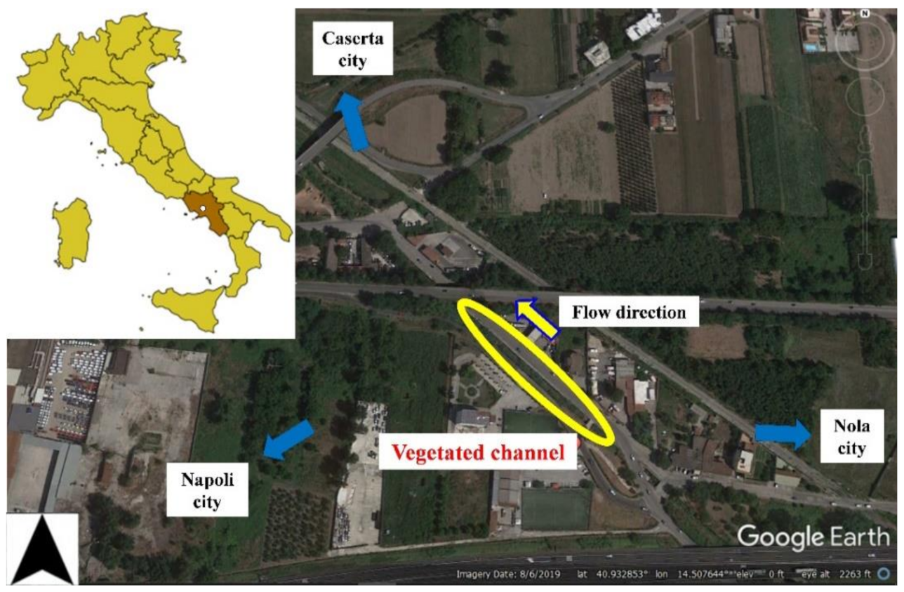
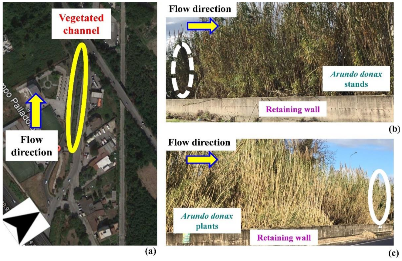
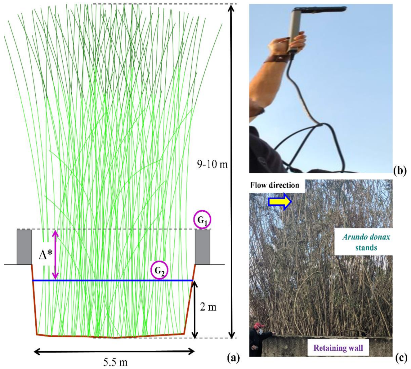
2.1. Study Area
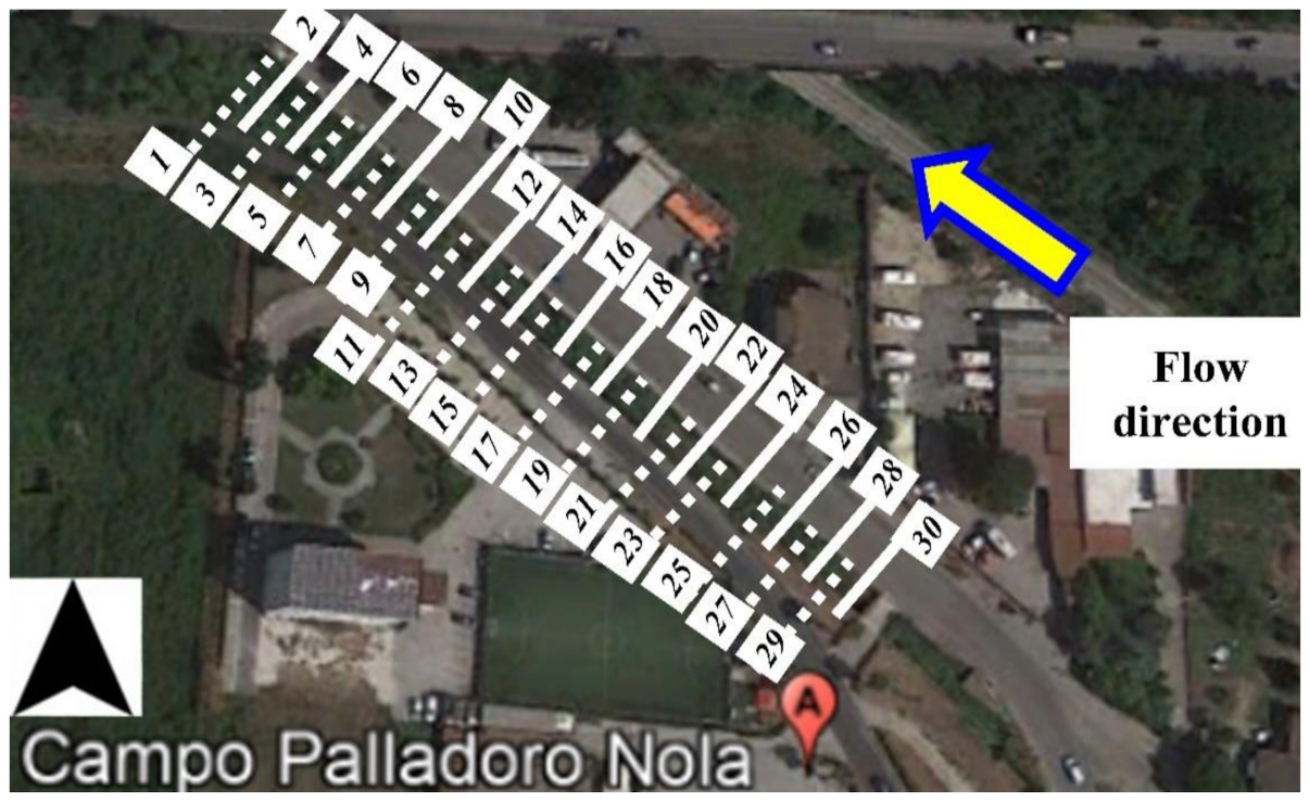
2.2. Experimental Hydrodynamic and Riparian Vegetation Measurements
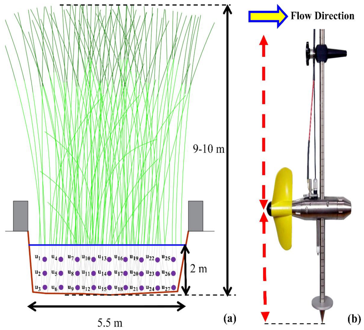
2.2.1. Hydrodynamic Response of Arundo donax Stands
2.2.2. Experimental Flow Average Velocity U Measurements
2.3. Experimental Measurements of Riparian Vegetation Indices
2.3.1. Arundo donax Stands’ LAI* Measurements
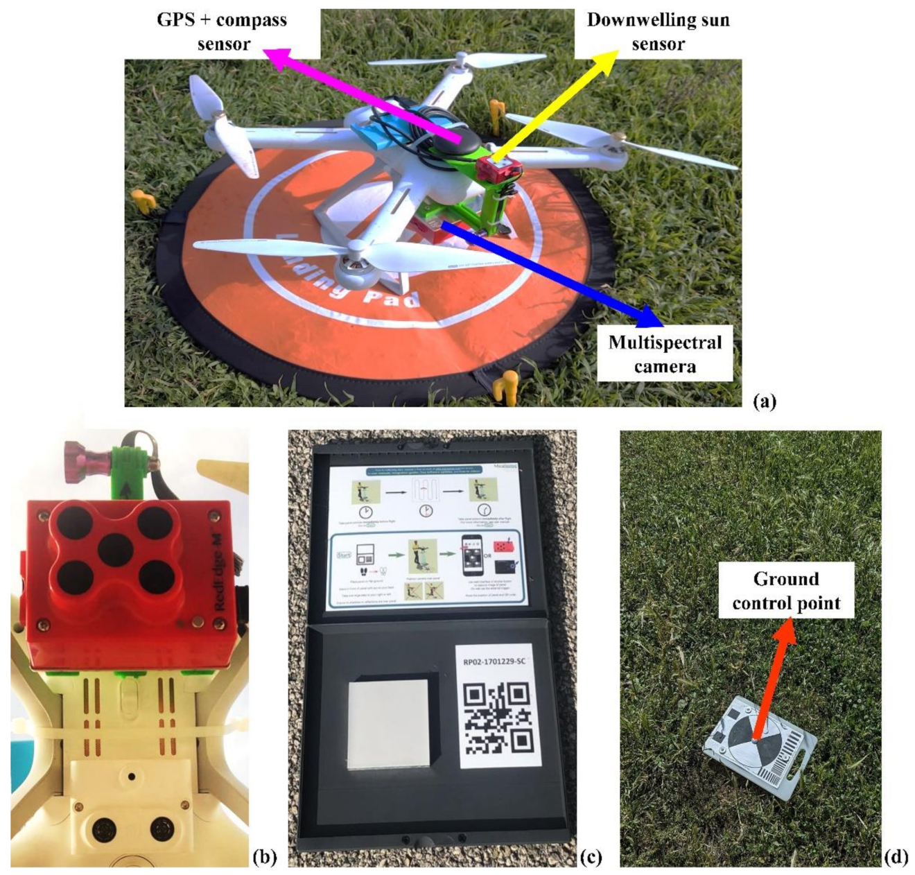
2.3.2. UAV-Acquired Multispectral Images
- Import photos and manually remove image outliers: photos taken before and during UAV take-off, during UAV landing, photos outside the boundaries of the experimental vegetated drainage channel;
- Conversion of geotagged images (WGS84) GPS coordinates to match GCPs coordinate system;
- Photo alignment and import GCPs list (also include the accuracy of 3D coordinates X/Y/Z);
- Verify and link markers to images. It was feasible to mark each GCP in 3–6 images since the acquired images and markers have the same coordinate reference system;
- Sparse point cloud cleaning, removing all points with reprojection error [30] higher than 1, camera alignment optimization, and dense cloud building;
- Digital Elevation Model (DEM) building from dense cloud and orthomosaic based on DEM.
2.3.3. Arundo donax Stands’ NDVI Map
2.3.4. Arundo donax Stands’ LAI* Map
2.4. Bulk Drag Coefficients Predictions
3. Results
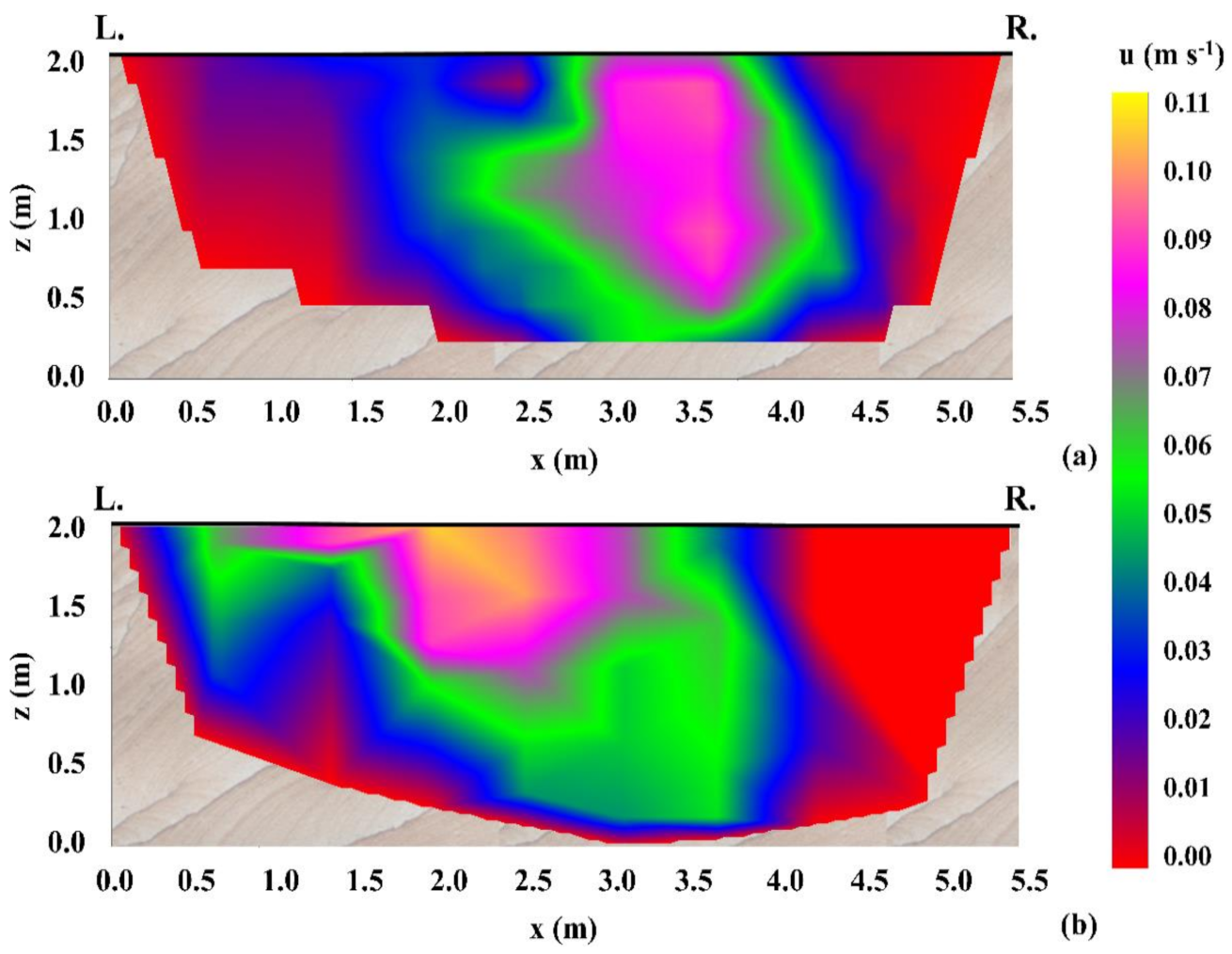
3.1. Flow Velocity Measurements
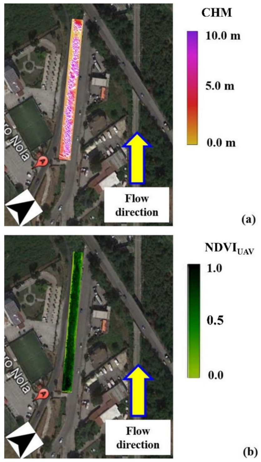
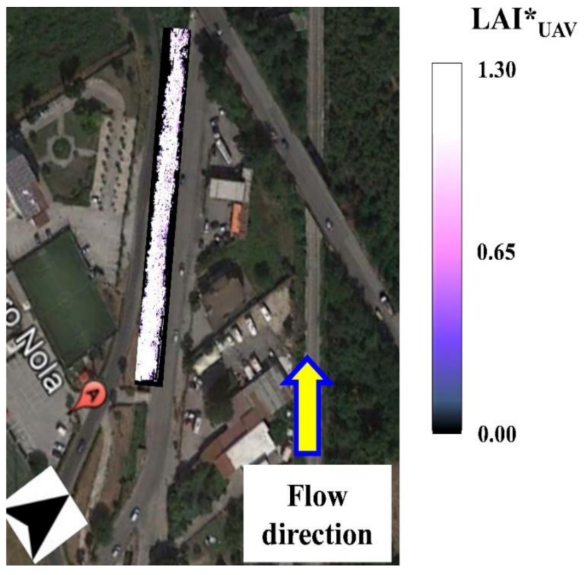
3.2. Arundo donax Stands’ NDVIUAV Map
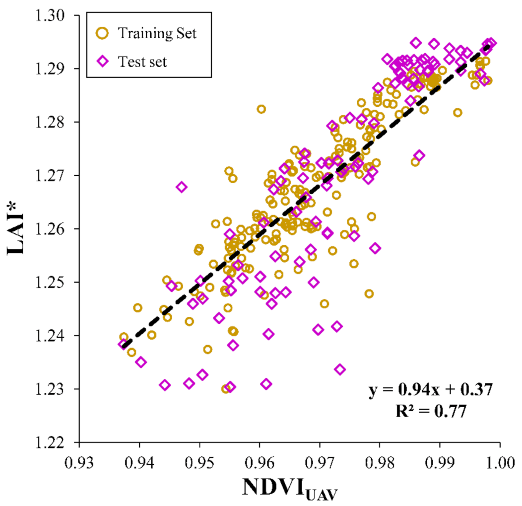
3.3. NDVIUAV and LAI* Correlation: Calibration and Validation
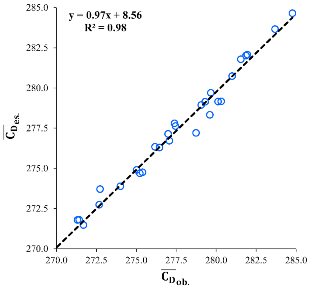
3.4. Comparison of Bulk Drag Coefficients Predictions
4. Discussion
5. Conclusions
Author Contributions
Funding
Informed Consent Statement
Data Availability Statement
Acknowledgments
Conflicts of Interest
References
- De Paola, F.; Ranucci, A. Analysis of spatial variability for stormwater capture tank assessment. Irrig. Drain. 2012, 61, 682–690. [Google Scholar] [CrossRef]
- Padulano, R.; Reder, A.; Rianna, G. An ensemble approach for the analysis of extreme rainfall under climate change in Naples (Italy). Hydrol. Process. 2019, 33, 2020–2036. [Google Scholar] [CrossRef]
- García-Gamero, V.; Peña, A.; Laguna, A.M.; Giráldez, J.V.; Vanwalleghem, T. Factors controlling the asymmetry of soil moisture and vegetation dynamics in a hilly mediterranean catchment. J. Hydrol. 2021, 126207. [Google Scholar] [CrossRef]
- Västilä, K.; Järvelä, J. Modeling the flow resistance of woody vegetation using physically based properties of the foliage and stem. Water Resour. Res. 2014, 50, 229–245. [Google Scholar] [CrossRef]
- Gualtieri, C.; Martone, I.; Filizola Junior, N.P.; Ianniruberto, M. Bedform Morphology in the Area of the Confluence of the Negro and Solimões-Amazon Rivers, Brazil. Water 2020, 12, 1630. [Google Scholar] [CrossRef]
- Schoelynck, J.; Struyf, E. Silicon in aquatic vegetation. Funct. Ecol. 2016, 30, 1323–1330. [Google Scholar] [CrossRef]
- Lama, G.F.C.; Chirico, G.B. Effects of reed beds management on the hydrodynamic behaviour of vegetated open channels. In Proceedings of the 2020 IEEE International Workshop on Metrology for Agriculture and Forestry (MetroAgriFor), Trento, Italy, 4–6 November 2020; pp. 149–154. [Google Scholar] [CrossRef]
- Breda, N.J.J. Ground-based measurements of leaf area index: A review of methods, instruments and current controversies. J. Exp. Bot. 2003, 54, 2403–2417. [Google Scholar] [CrossRef]
- Rhee, D.S.; Woo, H.; Kwon, B.; Ahn, H.K. Hydraulic resistance of some selected vegetation in open channel flows. River Res. Appl. 2008, 24, 673–687. [Google Scholar] [CrossRef]
- Cáceres-Euse, A.; Variano, E.A.; Toro-Botero, F.M.; Gómez-Giraldo, A.; Osorio, A.F. Simplified Model for Oscillatory Flow-Submerged Canopy Interaction. J. Hydraul. Eng. 2020, 146, 040200732. [Google Scholar] [CrossRef]
- Zhu, L.; Chen, Q. Numerical Modeling of Surface Waves over Submerged Flexible Vegetation. J. Eng. Mech. 2015, 141. [Google Scholar] [CrossRef]
- Tahvildari, N. Numerical modeling of the interactions between nonlinear waves and arbitrarily flexible vegetation. Coast. Eng. Proc. 2017, 1, 32. [Google Scholar] [CrossRef]
- Taddia, Y.; Russo, P.; Lovo, S.; Pellegrinelli, A. Multispectral UAV monitoring of submerged seaweed in shallow water. Appl. Geomat. 2020, 12, 19–34. [Google Scholar] [CrossRef]
- Li, Z.; Chen, H.; White, J.C.; Wulder, M.A.; Hermosilla, T. Discriminating treed and non-treed wetlands in boreal ecosystems using time series Sentinel-1 data. Int. J. Appl. Earth. Obs. 2020, 85, 102007. [Google Scholar] [CrossRef]
- Sannino, M.; Piscopo, R.; Serrapica, F.; Masucci, F.; di Francia, A.; Assirelli, A.; Cervelli, E.; Faugno, S. On Farm Evaluation of Maize Biomass, Dry Matter and Crude Protein by Using Yield Monitor Equipment. In Proceedings of the 28th European Biomass Conference and Exhibition Proceedings, on online, 6–9 July 2020; pp. 103–106. [Google Scholar] [CrossRef]
- Chasmer, L.; Mahoney, C.; Millard, K.; Nelson, K.; Peters, D.; Merchant, M.; Hopkinson, C.; Brisco, B.; Niemann, O.; Montgomery, J.; et al. Remote Sensing of Boreal Wetlands 2: Methods for Evaluating Boreal Wetland Ecosystem State and Drivers of Change. Remote Sens. 2020, 12, 1321. [Google Scholar] [CrossRef]
- Bustamante, J.; Aragonés, D.; Afán, I.; Luque, C.J.; Pérez-Vázquez, A.; Castellanos, E.M.; Díaz-Delgado, R. Hyperspectral sensors as a management tool to prevent the invasion of the exotic cordgrass Spartina densiflora in the Doñana wetlands. Remote Sens. 2016, 8, 1001. [Google Scholar] [CrossRef]
- Etminan, V.; Lowe, R.J.; Ghisalberti, M. A new model for predicting the drag exerted by vegetation canopies. Water Resour. Res. 2017, 53, 3179–3196. [Google Scholar] [CrossRef]
- Magliulo, G.; Petrone, C.; Capozzi, V.; Maddaloni, G.; Lopez, P.; Manfredi, G. Seismic performance evaluation of plasterboard partitions via shake table tests. Bull. Earthquake Eng. 2014, 12, 1657–1677. [Google Scholar] [CrossRef]
- Lama, G.F.C. Flow Resistance in Open Channels Colonized by Phragmites australis: Field Experiments and Modeling. Ph.D. Thesis, Water Resources Management and Biosystems Engineering Division, Department of Agricultural Sciences, University of Naples Federico II, Naples, Italy, 8 May 2020. [Google Scholar]
- Adão, T.; Hruška, J.; Pádua, L.; Bessa, J.; Peres, E.; Morais, R.; Sousa, J.J. Hyperspectral Imaging: A Review on UAV-Based Sensors, Data Processing and Applications for Agriculture and Forestry. Remote Sens. 2017, 9, 1110. [Google Scholar] [CrossRef]
- Khaliq, A.; Comba, L.; Biglia, A.; Ricauda Aimonino, D.; Chiaberge, M.; Gay, P. Comparison of Satellite and UAV-Based Multispectral Imagery for Vineyard Variability Assessment. Remote Sens. 2019, 11, 436. [Google Scholar] [CrossRef]
- Bianco, F.; Race, M.; Papirio, S.; Oleszczuk, P.; Esposito, G. The addition of biochar as a sustainable strategy for the remediation of PAH-contaminated sediments. Chemosphere 2021, 263, 128274. [Google Scholar] [CrossRef]
- Papirio, S. Coupling acid pretreatment and dosing of Ni and Se enhances the biomethane potential of hazelnut skin. J. Clean. Prod. 2020, 262, 12140. [Google Scholar] [CrossRef]
- Motohka, T.; Nasahara, K.N.; Oguma, H.; Tsuchida, S. Applicability of Green-Red Vegetation Index for Remote Sensing of Vegetation Phenology. Remote Sens. 2010, 2, 2369–2387. [Google Scholar] [CrossRef]
- Lama, G.F.C.; Errico, A.; Pasquino, V.; Mirzaei, S.; Preti, F.; Chirico, G.B. Velocity Uncertainty Quantification based on Riparian Vegetation Indices in open channels colonized by Phragmites australis. J. Ecohydraul. 2021, in press. [Google Scholar]
- Mamaghani, B.; Salvaggio, C. Multispectral Sensor Calibration and Characterization for sUAS Remote Sensing. Sensors 2019, 19, 4453. [Google Scholar] [CrossRef] [PubMed]
- Hakala, T.; Markelin, L.; Honkavaara, E.; Scott, B.; Theocharous, T.; Nevalainen, O.; Näsi, R.; Suomalainen, J.; Viljanen, N.; Greenwell, C.; et al. Direct Reflectance Measurements from Drones: Sensor Absolute Radiometric Calibration and System Tests for Forest Reflectance Characterization. Sensors 2018, 18, 1417. [Google Scholar] [CrossRef]
- Desta, E.; Nex, F.; Kerle, N. Accuracy assessment of real-time kinematics (RTK) measurements on unmanned aerial vehicles (UAV) for direct geo-referencing. Geo. Spat. Inf. Sci. 2020, 23, 165–181. [Google Scholar]
- López-Martínez, A.; Cuevas, F.J. Multiple View Relations Using the Teaching and Learning-Based Optimization Algorithm. Computers 2020, 9, 101. [Google Scholar] [CrossRef]
- Pijl, A.; Tosoni, M.; Roder, G.; Sofia, G.; Tarolli, P. Design of Terrace Drainage Networks Using UAV-Based High-Resolution Topographic Data. Water 2019, 11, 814. [Google Scholar] [CrossRef]
- Pijl, A.; Quarella, E.; Vogel, T.A.; D’Agostino, V.; Tarolli, P. Remote sensing vs. field-based monitoring of agricultural terrace degradation. Int. Soil Water Conserv. Res. 2021, 9, 1–10. [Google Scholar] [CrossRef]
- Di Nisio, A.; Adamo, F.; Acciani, G.; Attivissimo, F. Fast Detection of Olive Trees Affected by Xylella Fastidiosa from UAVs Using Multispectral Imaging. Sensors 2020, 20, 4915. [Google Scholar] [CrossRef]
- Micasense Inc. Automatic Calibration Panel Detection (QR Mode). Available online: https://support.micasense.com/hc/en-us/articles/360018618774 (accessed on 14 December 2020).
- Hashimoto, N.; Saito, Y.; Homma, K. Simulation of Reflectance and Vegetation Indices for Unmanned Aerial Vehicle (UAV) Monitoring of Paddy Fields. Remote Sens. 2019, 11, 2119. [Google Scholar] [CrossRef]
- Li, S.; Yuan, F.; Ata-UI-Karim, S.T.; Zheng, H.; Cheng, T.; Liu, X.; Tian, Y.; Zhu, Y.; Cao, W.; Cao, Q. Combining Color Indices and Textures of UAV-Based Digital Imagery for Rice LAI Estimation. Remote Sens. 2019, 11, 1763. [Google Scholar] [CrossRef]
- Martínez-Guanter, J.; Egea, G.; Pérez-Ruiz, M.; Apolo-Apolo, O.E. Estimation of the Leaf Area Index in Maize Based on UAV Imagery Using Deep Learning Techniques, in Precision Agriculture; Wageningen Academic Publishers: Wageningen, The Netherlands, 2019; pp. 389–395. [Google Scholar] [CrossRef]
- Rouse, J.W., Jr.; Haas, R.H.; Schell, J.A.; Deering, D.W. Monitoring vegetation systems in the Great Plains with ERTS. In Third Earth Resources Technology Satellite-1 Symposium: Section A-B. Technical Presentations; Stanley, C., Freden, E.P., Mercanti, M., Becker, A., Eds.; Scientific and Technical Information Office, National Aeronautics and Space Administration: Washington, DC, USA, 1974; pp. 309–329. [Google Scholar]
- Sarghini, F.; De Vivo, A. Analysis of preliminary design requirements of a heavy lift multirotor drone for agricultural use. Chem. Eng. Trans. 2017, 58, 625–630. [Google Scholar] [CrossRef]
- Arsenault, R.; Brissette, F.; Martel, J.-L. The hazards of split-sample validation in hydrological model calibration. J. Hydrol. 2018, 566, 346–362. [Google Scholar] [CrossRef]
- Jimenez-Berni, J.A.; Deery, D.M.; Rozas-Larraondo, P.; Condon, A.G.; Rebetzke, G.J.; James, R.A.; Bovill, W.D.; Furbank, R.T.; Sirault, X.R.R. High Throughput Determination of Plant Height, Ground Cover, and Above-Ground Biomass in Wheat with LiDAR. Front. Plant Sci. 2018, 9, 237. [Google Scholar] [CrossRef] [PubMed]
- Fabbrini, F.; Ludovisi, R.; Alasia, O.; Flexas, J.; Douthe, C.; Ribas Carbó, R.; Robson, P.; Taylor, G.; Scarascia-Mugnozza, G.; Keurentjes, J.J.B.; et al. Characterization of phenology, physiology, morphology and biomass traits across a broad Euro-Mediterranean ecotypic panel of the lignocellulosic feedstock Arundo donax. GCB Bioenergy 2019, 11, 152–170. [Google Scholar] [CrossRef]
- Raj, R.; Suradhaniwar, S.; Nandan, R.; Jagarlapudi, A.; Walker, J. Drone-Based Sensing for Leaf Area Index Estimation of Citrus Canopy. In Proceedings of UASG 2019. Lecture Notes in Civil Engineering; Jain, K., Khoshelham, K., Zhu, X., Tiwari, A., Eds.; Springer: Cham, Switzerland, 2020; Volume 51, pp. 79–89. [Google Scholar]
- Candiago, S.; Remondino, F.; De Giglio, M.; Dubbini, M.; Gattelli, M. Evaluating Multispectral Images and Vegetation Indices for Precision Farming Applications from UAV Images. Remote Sens. 2015, 7, 4026–4047. [Google Scholar] [CrossRef]
- Fagnano, M.; Impagliazzo, A.; Mori, M.; Fiorentino, N. Agronomic and Environmental Impacts of Giant Reed (Arundo donax L.): Results from a Long-Term Field Experiment in Hilly Areas Subject to Soil Erosion. Bioenergy Res. 2015, 8, 415–422. [Google Scholar] [CrossRef]
- Tan, C.W.; Zhang, P.P.; Zhou, X.X.; Wang, Z.X.; Xu, Z.Q.; Mao, W.; Li, W.X.; Huo, Z.Y.; Guo, W.S.; Yun, F. Quantitative monitoring of leaf area index in wheat of different plant types by integrating NDVI and Beer-Lambert law. Sci. Rep. 2020, 10, 929. [Google Scholar] [CrossRef]
- Luhar, M.; Nepf, H.M. From the blade scale to the reach scale: A characterization of aquatic vegetative drag. Adv. Water Res. 2013, 51, 305–316. [Google Scholar] [CrossRef]
- Zhang, X.; Nepf, H.M. Flow-induced reconfiguration of aquatic plants, including the impact of leaf sheltering. Limnol. Oceanogr. 2020, 65, 2697–2712. [Google Scholar] [CrossRef]
- Lama, G.F.C.; Errico, A.; Francalanci, S.; Solari, L.; Preti, F.; Chirico, G.B. Evaluation of Flow Resistance Models Based on Field Experiments in a Partly Vegetated Reclamation Channel. Geosciences 2020, 10, 47. [Google Scholar] [CrossRef]
- Errico, A.; Lama, G.F.C.; Francalanci, S.; Chirico, G.B.; Solari, L.; Preti, F. Flow dynamics and turbulence patterns in a drainage channel colonized by common reed (Phragmites australis) under different scenarios of vegetation management. Ecol. Eng. 2019, 133, 39–52. [Google Scholar] [CrossRef]
- Gijón Mancheño, A.; Jansen, W.; Winterwerp, J.C.; Uijttewaal, W.S.J. Predictive model of bulk drag coefficient for a nature-based structure exposed to currents. Sci. Rep. 2021, 11, 3517. [Google Scholar] [CrossRef]
- Tinoco, R.O.; San Juan, J.E.; Mullarney, C. Simplification bias: Lessons from laboratory and field experiments on flow through aquatic vegetation. Earth Surf. Process. Landf. 2020, 45, 121–143. [Google Scholar] [CrossRef]
- Capolupo, A.; Nasta, P.; Palladino, M.; Cervelli, E.; Boccia, L.; Romano, N. Assessing the ability of hybrid poplar for in-situ phytoextraction of cadmium by using UAV-photogrammetry and 3D flow simulator. Int. J. Remote Sens. 2018, 39, 5175–5194. [Google Scholar] [CrossRef]
- Pelosi, A.; Villani, P.; Falanga Bolognesi, S.; Chirico, G.B.; D’Urso, G. Predicting Crop Evapotranspiration by Integrating Ground and Remote Sensors with Air Temperature Forecasts. Sensors 2020, 20, 1740. [Google Scholar] [CrossRef]
- Padulano, R.; Lama, G.F.C.; Rianna, G.; Santini, M.; Mancini, M.; Stojiljkovic, M. Future rainfall scenarios for the assessment of water availability in Italy. In Proceedings of the 2020 IEEE International Workshop on Metrology for Agriculture and Forestry (MetroAgriFor), Trento, Italy, 4–6 November 2020; pp. 241–246. [Google Scholar] [CrossRef]
- Esposito, M.; Crimaldi, M.; Cirillo, V.; Sarghini, F.; Maggio, A. Drone and sensor technology for sustainable weed management: A review. Chem. Biol. Technol. Agric. 2021, 8, 18. [Google Scholar] [CrossRef]
- Crimaldi, M.; Cristiano, V.; De Vivo, A.; Isernia, M.; Ivanov, P.; Sarghini, F. Neural Network Algorithms for Real Time Plant Diseases Detection Using UAVs. In Innovative Biosystems Engineering for Sustainable Agriculture, Forestry and Food Production; Coppola, A., Di Renzo, G., Altieri, G., D’Antonio, P., Eds.; Springer: Cham, Switzerland, 2020; pp. 827–835. [Google Scholar] [CrossRef]
- Pizarro, A.; Dal Sasso, S.F.; Perks, M.T.; Manfreda, S. Identifying the optimal spatial distribution of tracers for optical sensing of stream surface flow. Hydrol. Earth Syst. Sc. 2020, 24, 5173–5185. [Google Scholar] [CrossRef]
- Licata, V.; D’Onofrio, A.; Silvestri, F. Microstructural factors affecting the static and the cyclic resistance of a pyroclastic silty sand. Géotechnique 2018, 5, 434–441. [Google Scholar] [CrossRef]
- Lama, G.C.; Gentile, G.; Cerruti, G.; Lavorgna, M.; Ambrogi, V.; Carfagna, C. Shape-Memory Nanocomposite Elastomers Filled with Carbon Nanomaterials. Adv. Sci. Technol. 2016, 100, 5–10. [Google Scholar] [CrossRef]
- Buonanomi, G.; Salvatori, N.; Zotti, M.G.; Stinca, A.; Motti, R.; Idbella, M.; Caternì, F.; Mazzoleni, S.; Giannino, F. Parasitic plant causes ephemeral “rainbow” pattern in a reservoir bank. J. Veg. Sci. 2020, 00, 1–12. [Google Scholar] [CrossRef]
- Lama, G.F.C.; Errico, A.; Francalanci, S.; Solari, L.; Chirico, G.B.; Preti, F. Hydraulic Modeling of Field Experiments in a Drainage Channel Under Different Riparian Vegetation Scenarios. In Innovative Biosystems Engineering for Sustainable Agriculture, Forestry and Food Production; Coppola, A., Di Renzo, G., Altieri, G., D’Antonio, P., Eds.; Springer: Cham, Switzerland, 2020; pp. 69–77. [Google Scholar] [CrossRef]
- Furlani, S.; Vaccher, V.; Macovaz, V.; Devoto, S. A Cost-Effective Method to Reproduce the Morphology of the Nearshore and Intertidal Zone in Microtidal Environments. Remote Sens. 2020, 12, 1880. [Google Scholar] [CrossRef]
- D’Ippolito, A.; Calomino, F.; Alfonsi, G.; Lauria, A. Flow Resistance in Open Channel Due to Vegetation at Reach Scale: A Review. Water 2021, 13, 116. [Google Scholar] [CrossRef]
- Lama, G.F.C.; Errico, A.; Francalanci, S.; Chirico, G.B.; Solari, L.; Preti, F. Comparative analysis of modeled and measured vegetative Chézy flow resistance coefficients in a drainage channel vegetated by dormant riparian reed. In Proceedings of the 2019 IEEE International Workshop on Metrology for Agriculture and Forestry (MetroAgriFor), Portici, Italy, 24–26 October 2019; pp. 180–184. [Google Scholar] [CrossRef]
- Jalonen, J.; Järvelä, J.; Virtanen, J.-P.; Vaaja, M.; Kurkela, M.; Hyyppä, H. Determining Characteristic Vegetation Areas by Terrestrial Laser Scanning for Floodplain Flow Modeling. Water 2015, 7, 420–437. [Google Scholar] [CrossRef]
- Nasta, P.; Allocca, C.; Deidda, R.; Romano, N. Assessing the impact of seasonal-rainfall anomalies on catchment-scale water balance components. Hydrol. Earth Syst. Sci. 2020, 24, 3211–3227. [Google Scholar] [CrossRef]


| Parameters | Ranges |
|---|---|
| Weight | 170 g (Including DLS) |
| Dimensions | 9.4 cm × 6.3 cm × 4.6 cm |
| Power | 4.2 V–15.8 V, 4 W nominal, 8 W peak |
| Spectral Bands | Narrowband: Blue, Green, Red, Red Edge, Near IR |
| Ground Sample Distance | 8.2 cm pixel−1 (per band) at 120 m–400 ft AGL |
| Max Capture Speed | 1 capture per second (all bands), 12-bit RAW |
| Band Number | Band Name | Center Wavelength (nm) | Bandwidth FWHM (nm) |
|---|---|---|---|
| 1 | Blue | 475 | 20 |
| 2 | Green | 560 | 20 |
| 3 | Red | 668 | 10 |
| 4 | Red Edge | 717 | 10 |
| 5 | Near IR | 840 | 40 |
| Cross-Section | A (m2) | χ (m) | R (m) | U (m s−1) |
|---|---|---|---|---|
| 1 | 8.695 | 8.120 | 1.071 | 0.01725 |
| 2 | 8.720 | 8.060 | 1.082 | 0.01720 |
| 3 | 8.705 | 8.115 | 1.073 | 0.01723 |
| 4 | 8.730 | 8.240 | 1.059 | 0.01718 |
| 5 | 8.656 | 8.145 | 1.063 | 0.01733 |
| 6 | 8.673 | 8.116 | 1.069 | 0.01730 |
| 7 | 8.689 | 8.148 | 1.066 | 0.01726 |
| 8 | 8.711 | 8.161 | 1.067 | 0.01722 |
| 9 | 8.654 | 8.162 | 1.060 | 0.01733 |
| 10 | 8.667 | 8.116 | 1.068 | 0.01731 |
| 11 | 8.734 | 8.129 | 1.074 | 0.01717 |
| 12 | 8.697 | 8.123 | 1.071 | 0.01725 |
| 13 | 8.710 | 8.144 | 1.069 | 0.01722 |
| 14 | 8.630 | 8.112 | 1.064 | 0.01738 |
| 15 | 8.724 | 8.130 | 1.073 | 0.01719 |
| 16 | 8.686 | 8.126 | 1.069 | 0.01727 |
| 17 | 8.724 | 8.115 | 1.075 | 0.01719 |
| 18 | 8.710 | 8.120 | 1.073 | 0.01722 |
| 19 | 8.700 | 8.112 | 1.072 | 0.01724 |
| 20 | 8.600 | 8.134 | 1.057 | 0.01744 |
| 21 | 8.670 | 8.171 | 1.061 | 0.01730 |
| 22 | 8.768 | 8.152 | 1.076 | 0.01711 |
| 23 | 8.713 | 8.114 | 1.074 | 0.01721 |
| 24 | 8.555 | 8.105 | 1.056 | 0.01753 |
| 25 | 8.668 | 8.130 | 1.066 | 0.01731 |
| 26 | 8.668 | 8.160 | 1.062 | 0.01731 |
| 27 | 8.665 | 8.117 | 1.068 | 0.01731 |
| 28 | 8.760 | 8.120 | 1.079 | 0.01712 |
| 29 | 8.631 | 8.128 | 1.062 | 0.01738 |
| 30 | 8.650 | 8.130 | 1.064 | 0.01734 |
Publisher’s Note: MDPI stays neutral with regard to jurisdictional claims in published maps and institutional affiliations. |
© 2021 by the authors. Licensee MDPI, Basel, Switzerland. This article is an open access article distributed under the terms and conditions of the Creative Commons Attribution (CC BY) license (https://creativecommons.org/licenses/by/4.0/).
Share and Cite
Lama, G.F.C.; Crimaldi, M.; Pasquino, V.; Padulano, R.; Chirico, G.B. Bulk Drag Predictions of Riparian Arundo donax Stands through UAV-Acquired Multispectral Images. Water 2021, 13, 1333. https://doi.org/10.3390/w13101333
Lama GFC, Crimaldi M, Pasquino V, Padulano R, Chirico GB. Bulk Drag Predictions of Riparian Arundo donax Stands through UAV-Acquired Multispectral Images. Water. 2021; 13(10):1333. https://doi.org/10.3390/w13101333
Chicago/Turabian StyleLama, Giuseppe Francesco Cesare, Mariano Crimaldi, Vittorio Pasquino, Roberta Padulano, and Giovanni Battista Chirico. 2021. "Bulk Drag Predictions of Riparian Arundo donax Stands through UAV-Acquired Multispectral Images" Water 13, no. 10: 1333. https://doi.org/10.3390/w13101333
APA StyleLama, G. F. C., Crimaldi, M., Pasquino, V., Padulano, R., & Chirico, G. B. (2021). Bulk Drag Predictions of Riparian Arundo donax Stands through UAV-Acquired Multispectral Images. Water, 13(10), 1333. https://doi.org/10.3390/w13101333