Small and Medium-Scale River Flood Controls in Highly Urbanized Areas: A Whole Region Perspective


Abstract
1. Introduction
2. Study Area and Data
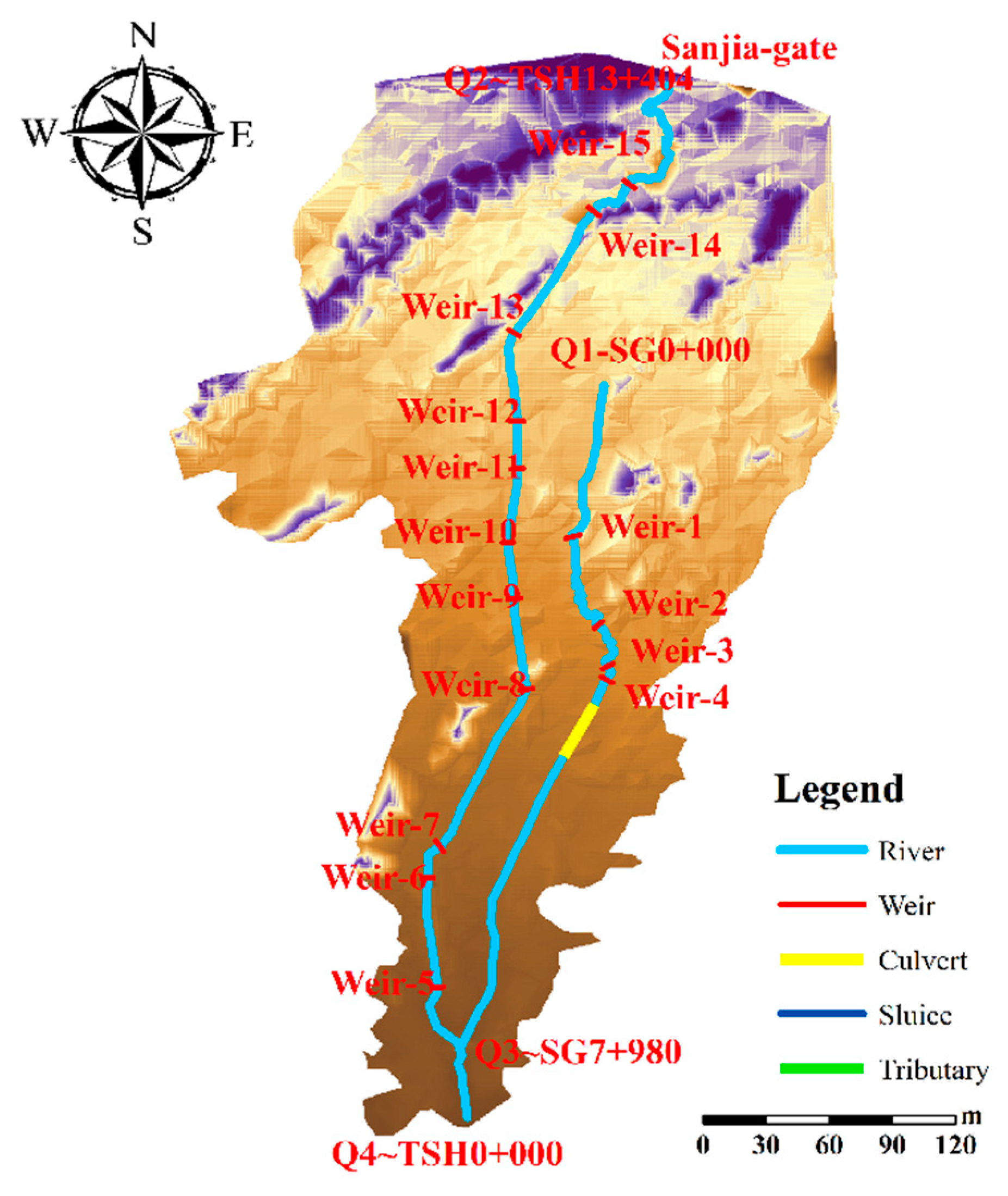
2.1. Study Area
2.2. Data
3. Methodology
3.1. Design Flood Calculation
3.2. Flood Simulation Model
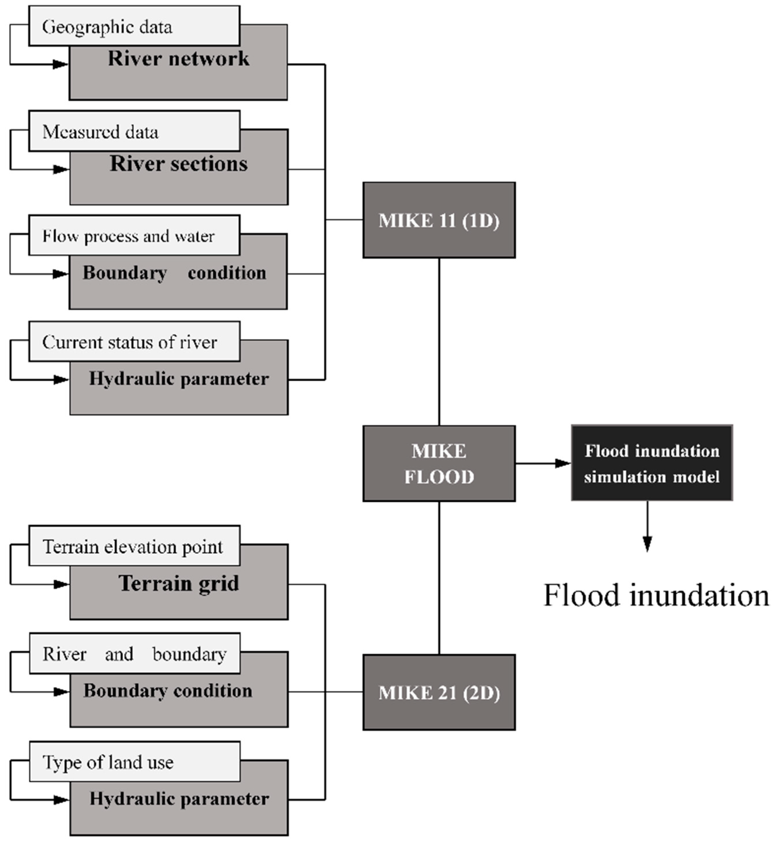
3.2.1. MIKE 11
3.2.2. MIKE 21
3.2.3. MIKE FLOOD
3.2.4. Model Verification
4. Results
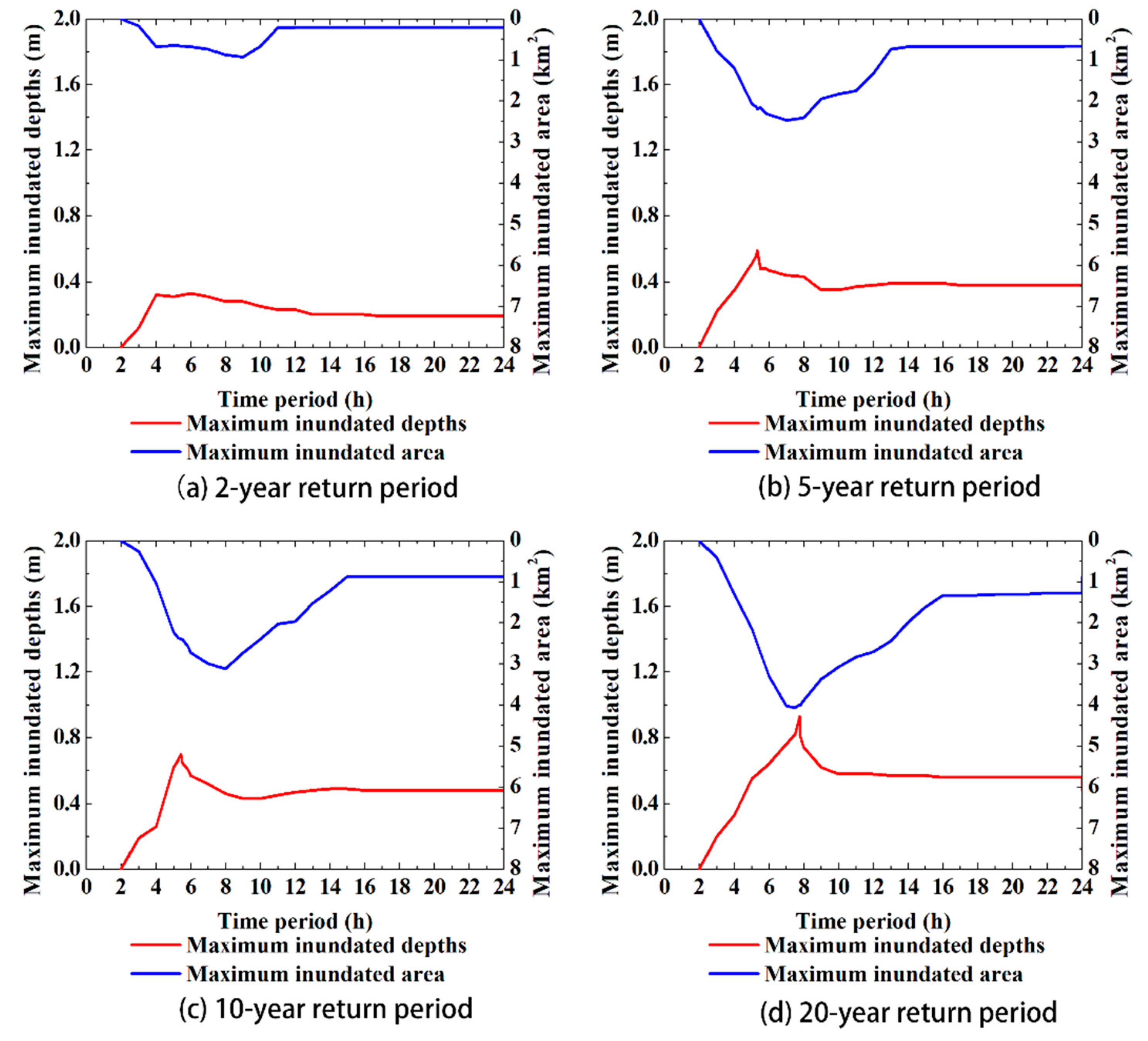
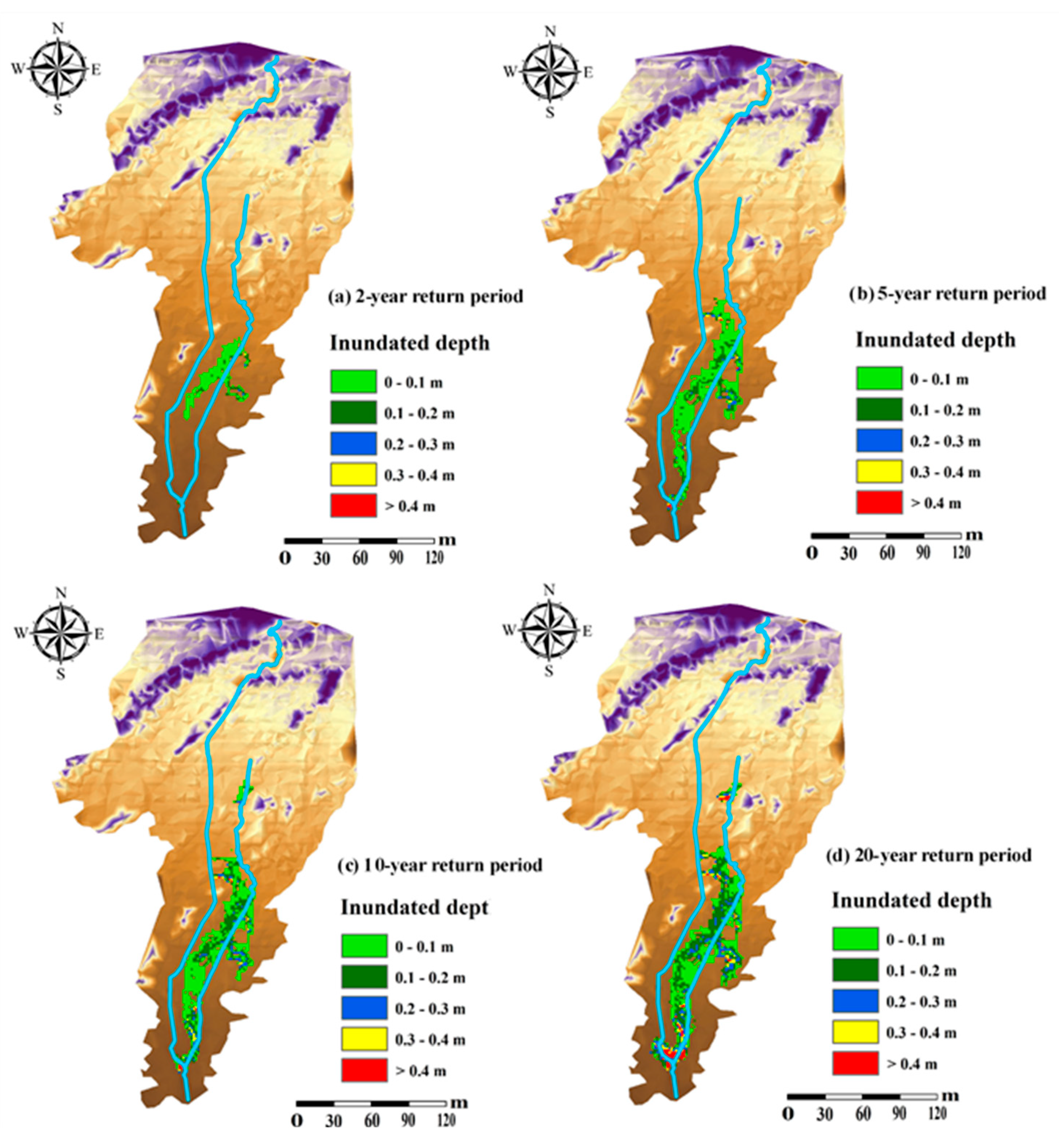
4.1. Flooding Analysis
4.2. River Regulation Schemes
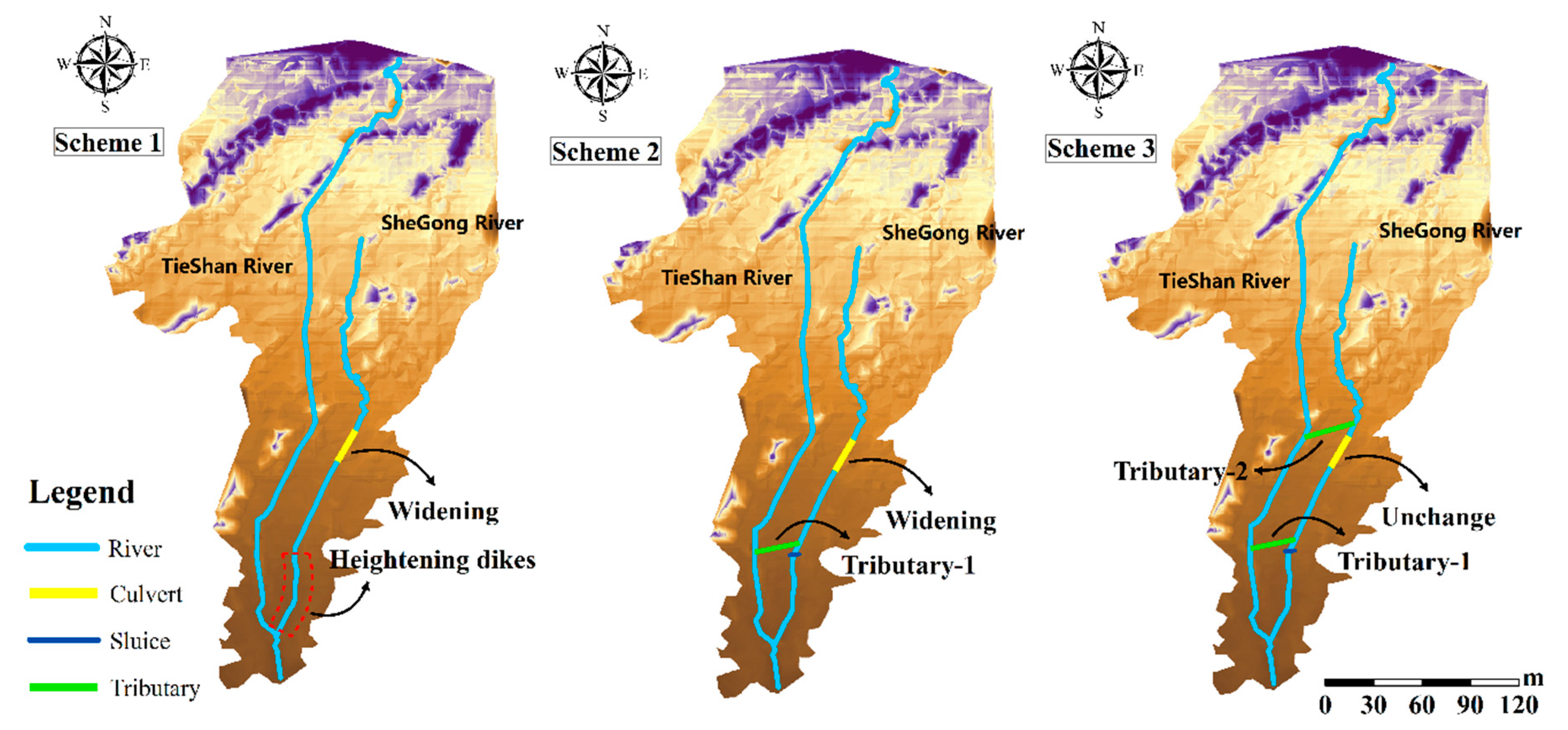
4.2.1. Formulation of River Regulation Schemes
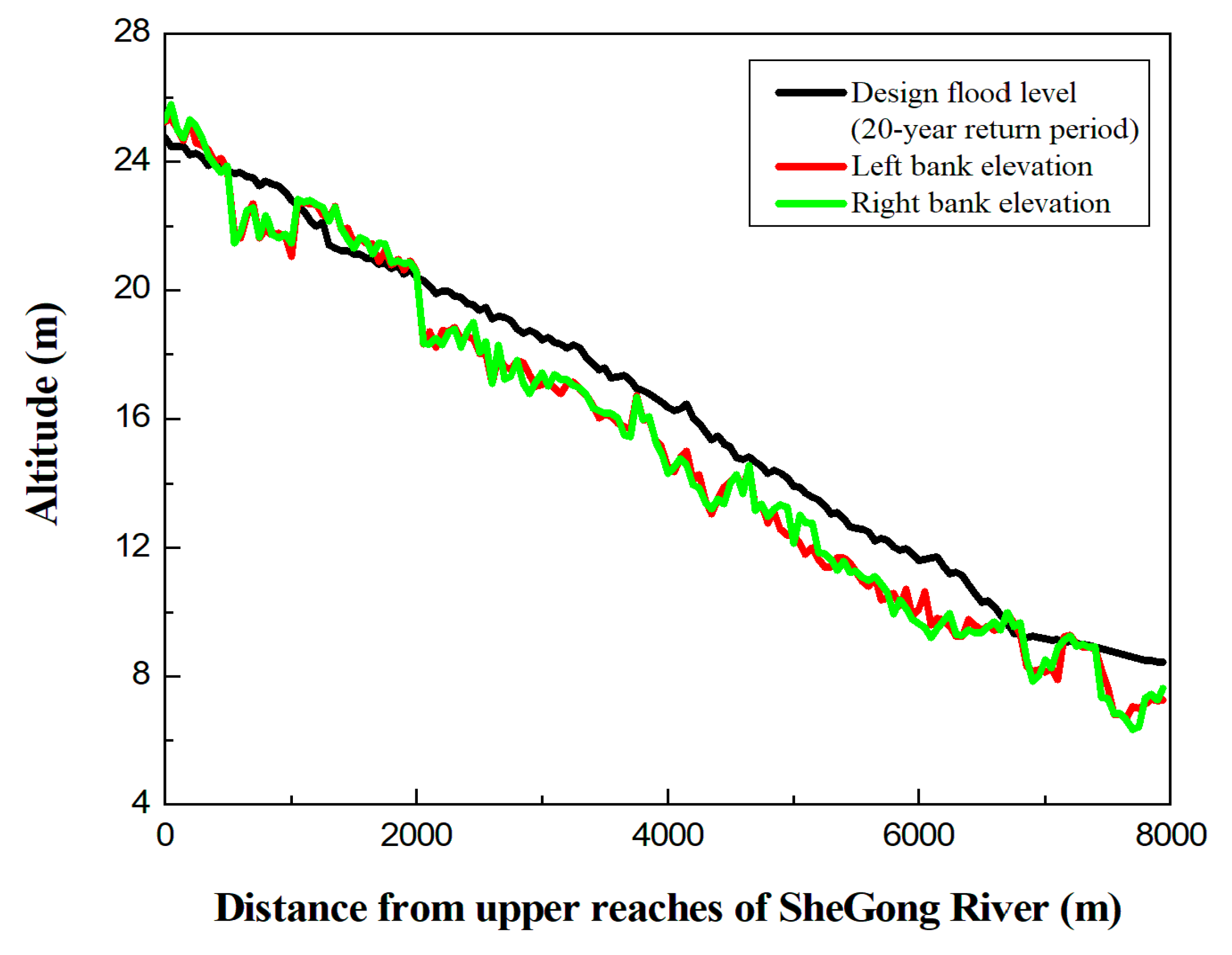
- The banks at the south of the SG5 + 600 pile are seriously invaded, resulting in the flood control capacity below the standard with a 5-year return period; developed urban areas in the vicinity are affected by flood seriously;
- At the north of the SG3 + 750 pile in SheGong River, there is a culvert with narrow section and shallow depth, which results in not enough flood discharge capacity of the river channel for flooding with a 2-year return period. Moreover, both sides of this culvert are construction lands; it is difficult to widen the culvert by land acquisition and demolition.
- (1)
- Scheme 1: Widening the downstream width and heightening dikes on both sides of the TieShan River to improve flood control capacity to reach the standard of a 20-year return period.
- (2)
- Scheme 2: Set a sluice at the SG5 + 600 section in the downstream of SheGong River, and open up the tributary-1 in front of the sluice, transferring flood water from the upstream of SheGong River to the downstream of TieShan River; meanwhile, widen the culvert at the north of the SG3 + 750 pile in the SheGong River.
- (3)
- Scheme 3: As in Scheme 2, i.e., set up sluice and open up tributary-1 in SheGong River; for the culvert, widen it slightly, and open up tributary-2 in front of the culvert, which leads part of the water flow into TieShan River before entering the culvert.
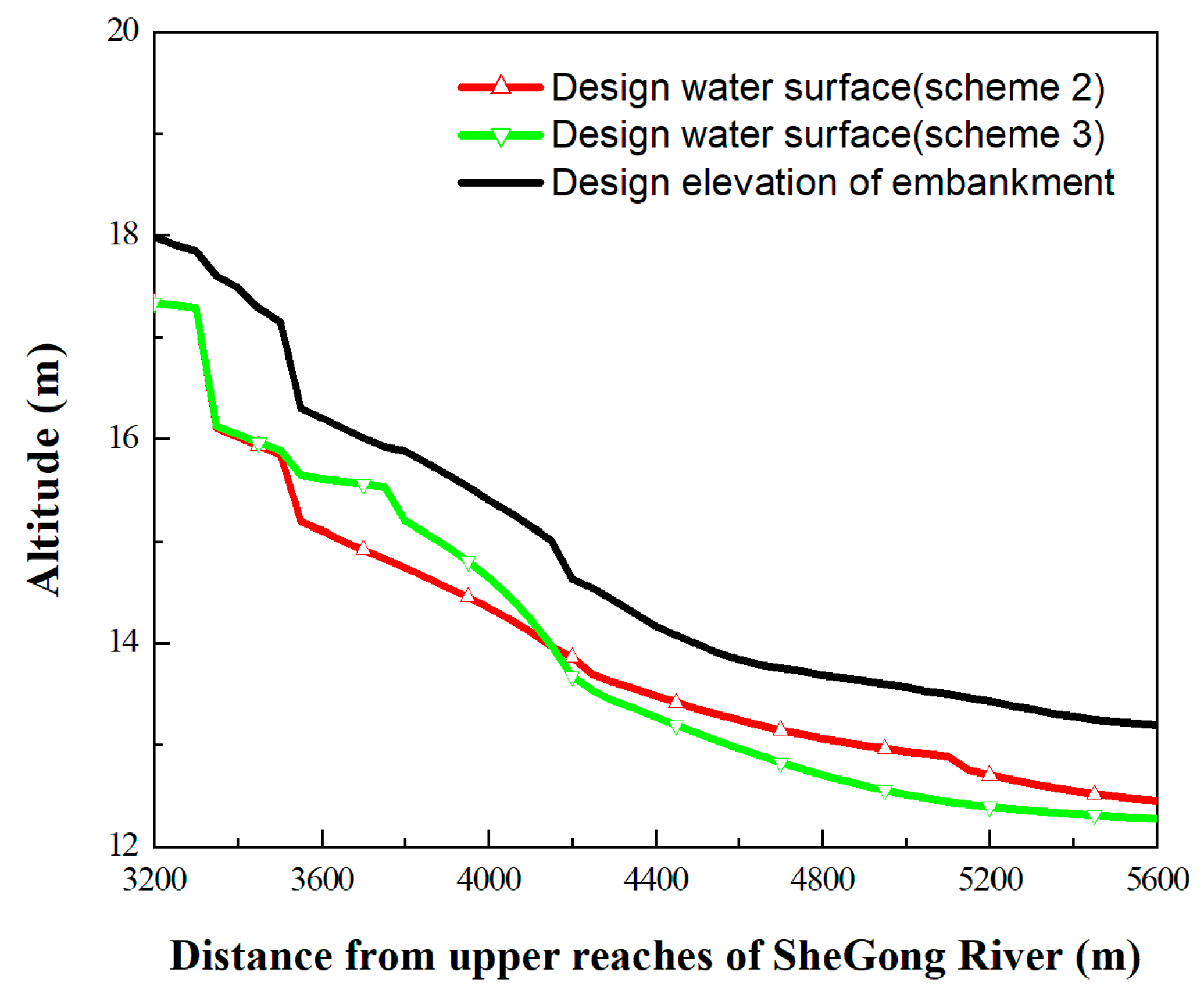
4.2.2. Comparison and Selection of Three Schemes
5. Discussion
6. Conclusions
Author Contributions
Funding
Acknowledgments
Conflicts of Interest
References
- Mileti, D.; Gailus, J.L. Sustainable development and hazards mitigation in the United States: Disasters by design revisited. Mitig. Adapt. Strateg. Glob. Chang. 2005, 10, 491–504. [Google Scholar] [CrossRef]
- Wu, X.; Wang, Z.; Guo, S.; Liao, W.; Zeng, Z.; Chen, X. Scenario-based projections of future urban inundation within a coupled hydrodynamic model framework: A case study in Dongguan City, China. J. Hydrol. 2017, 547, 428–442. [Google Scholar] [CrossRef]
- Chen, M.; Pang, J.; Wu, P. Flood Routing Model with Particle Filter-Based Data Assimilation for Flash Flood Forecasting in the Micro-Model of Lower Yellow River, China. Water 2018, 10, 1612. [Google Scholar] [CrossRef]
- Wu, X.; Guo, S.; Liu, D.; Hong, X.; Liu, Z.; Liu, P.; Chen, H. Characterization of rainstorm modes along the upper mainstream of Yangtze River during 2003–2016. Int. J. Climatol. 2018, 38, 1976–1988. [Google Scholar] [CrossRef]
- Jung, I.W.; Chang, H.; Moradkhani, H. Quantifying uncertainty in urban flooding analysis considering hydro-climatic projection and urban development effects. Hydrol. Earth Syst. Sci. 2011, 15, 617–633. [Google Scholar] [CrossRef]
- Wang, Z.; Lai, C.; Chen, X.; Yang, B.; Zhao, S.; Bai, X. Flood hazard risk assessment model based on random forest. J. Hydrol. 2015, 527, 1130–1141. [Google Scholar] [CrossRef]
- Chang, L.C.; Amin, M.; Yang, S.N.; Chang, F.J. Building ANN-Based Regional Multi-Step-Ahead Flood Inundation Forecast Models. Water 2018, 10, 1283. [Google Scholar] [CrossRef]
- Xi, F.; He, H.S.; Clarke, K.C.; Hu, Y.; Wu, X.; Liu, M.; Gao, C. The potential impacts of sprawl on farmland in Northeast China-Evaluating a new strategy for rural development. Landsc. Urban Plan. 2012, 104, 34–46. [Google Scholar] [CrossRef]
- Chang, L.C.; Chang, F.J.; Yang, S.N.; Kao, I.; Ku, Y.Y.; Kuo, C.L.; Amin, I. Building an Intelligent Hydroinformatics Integration Platform for Regional Flood Inundation Warning Systems. Water 2019, 11, 9. [Google Scholar] [CrossRef]
- Yin, J.; Yin, Z.; Wang, J.; Xu, S. National assessment of coastal vulnerability to sea-level rise for the Chinese coast. J. Coast Conserv. 2012, 16, 123–133. [Google Scholar] [CrossRef]
- Jabbari, A.; Bae, D.-H. Application of Artificial Neural Networks for Accuracy Enhancements of Real-Time Flood Forecasting in the Imjin Basin. Water 2018, 10, 1626. [Google Scholar] [CrossRef]
- Lai, C.; Shao, Q.; Chen, X.; Wang, Z.; Zhou, X.; Yang, B.; Zhang, L. Flood risk zoning using a rule mining based on ant colony algorithm. J. Hydrol. 2016, 542, 268–280. [Google Scholar] [CrossRef]
- Huong, H.T.L.; Pathirana, A. Urbanization and climate change impacts on future urban flooding in Can Tho city, Vietnam. Hydrol. Earth Syst Sci. 2013, 17, 379–394. [Google Scholar] [CrossRef]
- Lai, C.; Chen, X.; Chen, X.; Wang, Z.; Wu, X.; Zhao, S. A fuzzy comprehensive evaluation model for flood risk based on the combination weight of game theory. Nat. Hazards 2015, 77, 1243–1259. [Google Scholar] [CrossRef]
- Quan, R. Rainstorm waterlogging risk assessment in central urban area of Shanghai based on multiple scenario simulation. Nat. Hazard 2014, 73, 1569–1585. [Google Scholar] [CrossRef]
- Mishra, B.K.; Herath, S. Assessment of future floods in the Bagmati River basin of Nepal using bia-corrected daily GCM precipitation data. J. Hydrol. Eng. 2015, 20, 8. [Google Scholar] [CrossRef]
- Saraswat, C.; Kumar, P.; Mishra, B.K. Assessment of stormwater runoff management practices and governance under climate change and urbanization: An analysis of Bangkok, Hanoi and Tokyo. Environ. Sci. Policy 2016, 64, 101–117. [Google Scholar] [CrossRef]
- Wu, X.; Guo, S.; Yin, J.; Yang, G.; Zhong, Y.; Liu, D. On the event-based extreme precipitation across China: Time distribution patterns, trends, and return levels. J. Hydrol. 2018, 562, 305–317. [Google Scholar] [CrossRef]
- Di Paola, F.; Ricciardelli, E.; Cimini, D.; Romano, F.; Viggiano, M.; Cuomo, V. Analysis of Catania flash flood case study by using combined microwave and infrared technique. J. Hydrometeorol. 2014, 15, 1989–1998. [Google Scholar] [CrossRef]
- Fu, G.; Butler, D.; Khu, S.T.; Sun, S.A. Imprecise probabilistic evaluation of sewer flooding in urban drainage systems using random set theory. Water Resour. Res. 2011, 47, W02534. [Google Scholar] [CrossRef]
- Hammond, M.J.; Chen, A.S.; Djordjević, S.; Butler, D.; Mark, O. Urban flood impact assessment: A state-of-the-art review. Urban Water J. 2015, 12, 14–29. [Google Scholar] [CrossRef]
- Vacondio, R.; Aureli, F.; Ferrari, A.; Mignosa, P.; Dal Palu, A. Simulation of the January 2014 flood on the Secchia River using a fast and high-resolution 2D parallel shallow-water numerial scheme. Nat. Hazards 2016, 80, 103–125. [Google Scholar] [CrossRef]
- Yang, L.; Smith, J.; Baeck, M.L.; Smith, B.; Tian, F.; Niyogi, D. Structure and evolution of flash flood producing storms in a small urban watershed. J. Geophys. Res. Atmos. 2016, 121, 3139–3152. [Google Scholar] [CrossRef]
- Bai, T.; Wei, J.; Yang, W.; Huang, Q. Multi-Objective Parameter Estimation of Improved Muskingum Model by Wolf Pack Algorithm and Its Application in Upper Hanjiang River, China. Water 2018, 10, 1415. [Google Scholar] [CrossRef]
- van den Honert, R.C.; McAneney, J. The 2011 Brisbane Flood: Causes, Impacts and Implications. Water 2011, 3, 1149–1173. [Google Scholar] [CrossRef]
- Rakwatin, P.; Sansena, T.; Marjang, N.; Rungsipanich, A. Using multi-temporal remote-sensing data to estimate 2011 flood area and volume over Chao Phraya River basin, Thailand. Remote Sens. Lett. 2012, 4, 243–250. [Google Scholar] [CrossRef]
- Zhang, H.; Ma, W.C.; Wang, X.R. Rapid urbanization and implications for flood risk management in hinterland of the Pearl River Delta, China: The Foshan study. Sensors 2008, 8, 2223–2239. [Google Scholar] [CrossRef]
- Wang, K.; Wang, L.; Wei, Y.-M.; Ye, M. Beijing storm of July 21, 2012: Observations and reflections. Nat. Hazards 2013, 67, 969–974. [Google Scholar] [CrossRef]
- Huang, Y.; Chen, S.; Cao, Q.; Hong, Y.; Wu, B.; Huang, M.; Qiao, L.; Zhang, Z.; Yang, X. Evaluation of Version-7 TRMM Multi-Satellite Precipitation Analysis Product during the Beijing Extreme Heavy Rainfall Event of 21 July 2012. Water 2013, 6, 32–44. [Google Scholar] [CrossRef]
- Jha, A.K.; Bloch, R.; Lamond, J. Cities and Flooding: A Guide to Integrated Urban Flood Risk Management for the 21st Cemtury. J. Reg. Sci. 2012, 52, 885–887. [Google Scholar] [CrossRef]
- Batisani, N.; Yarnal, B. Urban expansion in Centre County, Pennsylvania: Spatial dynamics and landscape transformations. Appl. Geogr. 2009, 29, 235–249. [Google Scholar] [CrossRef]
- Wu, X.; Wang, Z.; Zhou, X.; Lai, C.; Lin, W.; Chen, X. Observed changes in precipitation extremes across 11 basins in China during 1961–2013. Int. J. Climatol. 2016, 36, 2866–2885. [Google Scholar] [CrossRef]
- Hassan, M.M.; Nazem, M.N.I. Examination of land use/land cover changes, urban growth dynamics, and environmental sustainability in Chittagong city, Bangladesh. J. Environ. Dev. Sustain. 2016, 18, 697–716. [Google Scholar] [CrossRef]
- Miguez, M.G.; Veról, A.P.; De Sousa, M.M.; Rezende, O.M. Urban floods in lowlands—Levee systems, unplanned urban growth and river restoration alternative: A case study in Brazil. Sustainability 2015, 7, 11068–11097. [Google Scholar] [CrossRef]
- Bruwier, M.; Mustafa, A.; Aliaga, D.G.; Archambeau, P.; Erpicum, S.; Nishida, G.; Zhang, X.; Pirotton, M.; Teller, J.; Dewals, B. Influence of urban pattern on inundation flow in floodplains of lowland rivers. Sci. Total Environ. 2018, 622, 446–458. [Google Scholar] [CrossRef]
- Cho, S.Y.; Chang, H. Recent research approaches to urban flood vulnerability, 2006–2016. Nat. Hazards 2017, 88, 633–649. [Google Scholar] [CrossRef]
- Luino, F.; Turconi, L.; Petrea, C.; Nigrelli, G. Uncorrected land-use planning highlighted by flooding: The Alba case study (Piedmont, Italy). Nat. Hazards Earth Syst. Sci. 2012, 12, 2329–2346. [Google Scholar] [CrossRef]
- Li, C.; Cheng, X.; Li, N.; Du, X.; Yu, Q.; Kan, G. A Framework for Flood Risk Analysis and Benefit Assessment of Flood Control Measures in Urban Areas. Int. J. Environ. Res. Public Health 2016, 13, 787. [Google Scholar] [CrossRef]
- Wu, X.; Wang, Z.; Guo, S.; Lai, C.; Chen, X. A simplified approach for flood modeling in urban environments. Hydrol. Res. 2018, 49, 1804–1816. [Google Scholar] [CrossRef]
- Dutta, D.; Herath, S.; Musiake, K. Flood inundation simulation in a river basin using a physically based distributed hydrologic model. Hydrol. Process. 2000, 14, 497–519. [Google Scholar] [CrossRef]
- Yazdi, J.; Neyshabouri, S.S. Optimal design of flood-control multi-reservoir system on a watershed scale. Nat. Hazards 2012, 63, 629–646. [Google Scholar] [CrossRef]
- Miller, J.D.; Kim, H.; Kjeldsen, T.R.; Packman, J.; Grebby, S.; Dearden, R. Assessing the impact of urbanization on storm runoff in a peri-urban catchment using historical change in impervious cover. J. Hydrol. 2014, 515, 59–70. [Google Scholar] [CrossRef]
- Kong, F.; Ban, Y.; Yin, H. Modeling stormwater management at the city district level in response to changes in land use and low impact development. Environ. Model. Softw. 2017, 95, 132–142. [Google Scholar] [CrossRef]
- Garg, V.; Aggarwal, S.P.; Gupta, P.K. Assessment of land use land cover change impact on hydrological regime of a basin. Environ. Earth Sci. 2017, 76, 635. [Google Scholar] [CrossRef]
- Li, J.; Wang, Z.; Lai, C. Severe drought events inducing large decrease of net primary productivity in mainland China during 1982–2015. Sci. Total Environ. 2019, in press. [Google Scholar] [CrossRef]
- Shokoohi, A.R. Assessment of Urban Basin Flood Control Measures Using Hydrogis Tools. J. Appl. Sci. 2007, 7, 1726–1733. [Google Scholar] [CrossRef]
- Miguez, M.G.; Mascarenhas, F.C.B.; Canedo de Magalhães, L.P.; D’Alterio, C.F.V. Planning and Design of Urban Flood Control Measures: Assessing Effects Combination. J. Urban Plan. Dev. 2009, 135, 100–109. [Google Scholar] [CrossRef]
- Gül, G.O.; Harmancıoğlu, N.; Gül, A. A combined hydrologic and hydraulic modeling approach for testing efficiency of structural flood control measures. Nat. Hazards 2009, 54, 245–260. [Google Scholar] [CrossRef]
- Pilarczyk, K.W.; Nuoi, N.S. Experience and Practices on Flood Control in Vietnam. Water Int. 2005, 30, 114–122. [Google Scholar] [CrossRef]
- Konrad, C.P. Effects of Urban Development on Floods; 076–03; U.S. Geol. Surv.: Washington, DC, USA, 2003.
- Liu, Z.; Zhang, H.; Liang, Q. A coupled hydrological and hydrodynamic model for flood simulation. Hydrol. Res. 2018, 50, 589–606. [Google Scholar] [CrossRef]
- Hu, C.Y.; Wang, J.X. Watershed Runoff Model and Hydrological Model; The Yellow River Water Conservancy Press: Zhengzhou, China, 2010. [Google Scholar]
- Raghunath, H.M. Hydrology Principles·Analysis·Design; New Age International Publishers: Manipal, Karnataka, India, 2006. [Google Scholar]
- Merz, B. Floods and climate: Emerging perspectives for flood risk assessment and management. Nat. Hazards Earth Syst. Sci. 2014, 2, 1559–1612. [Google Scholar] [CrossRef]
- Fan, Y.; Ao, T.; Yu, H.; Huang, G.; Li, X. A Coupled 1D-2D Hydrodynamic Model for Urban Flood Inundated. Adv. Meteorol. 2017, 2017, 2819308. [Google Scholar] [CrossRef]


| Section | Station Number | Discharge Number | Discharge for Different Return Period (m3/s) | |||
|---|---|---|---|---|---|---|
| 2a | 5a | 10a | 20a | |||
| Sanjia sluice | TieShan River TSH13 + 404 | Q1 | 108.5 | 156.3 | 188.1 | 281.0 |
| 7#weir | TieShan River TSH3 + 600 | Q2 | 149.6 | 218.8 | 259.6 | 348.7 |
| The source of SheGong River | SheGong River SG0 + 000 | Q3 | 11.9 | 18.0 | 22.4 | 26.5 |
| SheGong sluice | SheGong River SG5 + 600 | Q4 | 26.7 | 40.5 | 50.4 | 59.2 |
| TieShan River estuary | TieShan River TSH0 + 000 | Q5 | 201.2 | 297.1 | 354.7 | 453.9 |
| Position | Station Number | Observed Values/m | Simulated Values/m | Bias/m |
|---|---|---|---|---|
| 7#weir | TSH3 + 720 | 13.02 | 13.03 | −0.01 |
| 8#weir | TSH5 + 640 | 16.77 | 16.95 | −0.18 |
| 9#weir | TSH6 + 570 | 19.31 | 19.26 | 0.05 |
| 10#weir | TSH7 + 200 | 21.21 | 21.27 | −0.06 |
| 11#weir | TSH8 + 180 | 23.6 | 23.69 | −0.09 |
| 12#weir | TSH8 + 700 | 26.16 | 26.34 | −0.18 |
| 13#weir | TSH9 + 640 | 28.81 | 28.69 | 0.12 |
| 14#weir | TSH11 + 210 | 31.69 | 31.74 | −0.05 |
| 15#weir | TSH11 + 800 | 33.68 | 33.72 | −0.04 |
| Scheme | Area of Land Acquisition and Demolition (m2) | Unit Price ($/m2) | Total Cost ($) | ||
|---|---|---|---|---|---|
| Construction Land | Farmland | Construction Land | Farmland | ||
| #2 | 11,861 | 64,989 | 24.31 | 4.29 | 558,702 |
| #3 | 3385 | 83,915 | 439,869 | ||
© 2020 by the authors. Licensee MDPI, Basel, Switzerland. This article is an open access article distributed under the terms and conditions of the Creative Commons Attribution (CC BY) license (http://creativecommons.org/licenses/by/4.0/).
Share and Cite
Liu, Z.; Cai, Y.; Wang, S.; Lan, F.; Wu, X. Small and Medium-Scale River Flood Controls in Highly Urbanized Areas: A Whole Region Perspective. Water 2020, 12, 182. https://doi.org/10.3390/w12010182
Liu Z, Cai Y, Wang S, Lan F, Wu X. Small and Medium-Scale River Flood Controls in Highly Urbanized Areas: A Whole Region Perspective. Water. 2020; 12(1):182. https://doi.org/10.3390/w12010182
Chicago/Turabian StyleLiu, Zengmei, Yuting Cai, Shangwei Wang, Fupeng Lan, and Xushu Wu. 2020. "Small and Medium-Scale River Flood Controls in Highly Urbanized Areas: A Whole Region Perspective" Water 12, no. 1: 182. https://doi.org/10.3390/w12010182
APA StyleLiu, Z., Cai, Y., Wang, S., Lan, F., & Wu, X. (2020). Small and Medium-Scale River Flood Controls in Highly Urbanized Areas: A Whole Region Perspective. Water, 12(1), 182. https://doi.org/10.3390/w12010182