Abstract
Wildfire is known to create the pre-conditions leading to accelerated soil erosion. Unfortunately, its occurrence is expected to increase with climate change. The objective of this study was to assess the impacts of fire on runoff and soil erosion in a context of global change, and to evaluate the effectiveness of mulching as a post-fire erosion mitigation measure. For this, the long-term soil erosion model LandSoil was calibrated for a Mediterranean catchment in north-central Portugal that burnt in 2011. LandSoil was then applied for a 20-year period to quantify the separate and combined hydrological and erosion impacts of fire frequency and of post-fire mulching using four plausible site-specific land use and management scenarios (S1. business-as-usual, S2. market-oriented, S3. environmental protection and S4. sustainable trade-off) and an intermediate climate change scenario Representative Concentration Pathway (RCP) 4.5 by 2050. The obtained results showed that: (i) fire had a reduced impact on runoff generation in the studied catchment (<5%) but a marked impact on sediment yield (SY) by about 30%; (ii) eucalypt intensification combined with climate change and fires can increase SY by threefold and (iii) post-fire mulching, combined with riparian vegetation maintenance/restoration and reduced tillage at the landscape level, was highly effective to mitigate soil erosion under global change and associated, increased fire frequency (up to 50% reduction). This study shows how field monitoring data can be combined with numerical erosion modeling to segregate the prominent processes occurring in post forest fire conditions and find the best management pathways to meet international goals on achieving land degradation neutrality (LDN).
1. Introduction
Erosion is a serious environmental problem worldwide including on-site effects (e.g., depletion in soil organic carbon stocks and decline in agronomic yields) and off-site effects (e.g., non-point source pollutions and reservoir siltation) [1]. Although it is a natural phenomenon, it can be exacerbated by climate change; fire and grazing [2] and is often accelerated by human activities [3]. The problem is especially disruptive in the Mediterranean area where erosion rates measured at the outlet of river basins of different sizes are high [4,5], especially because soils are usually thinner than in northern Europe [6] but also because croplands of the Mediterranean have a predominance of fallow land and lack of adoption of conservation practices [7]. The Mediterranean basin is very prone to erosion in all its forms because of the climate, topography, soil characteristics and a very long history of human presence and intense cultivation [8,9]. In addition, the occurrence of human-related forest fires affecting thousands of hectares each year is also a significant problem in both the northern and southern areas of the Mediterranean basin because wildfires have frequently been reported to produce strong and sometimes extreme hydrological and erosion responses in recently burnt areas, especially during the first few post-fire years [10,11].
Mediterranean-type ecosystems are particularly prone to fires, as the cool wet season is propitious for vegetation growth and fuel production, while the summer dry season promotes the drying of fuel and propitious conditions for fire occurrence and spread [12]. In the north-western Iberian Peninsula, the more humid climate has favored the commercial plantation of fast-growing but fire-prone species such as eucalypts and maritime pines, further exacerbating the wildfire problem [13]. Besides damaging vegetation and leading to loss of life and property, fires have a large number of indirect impacts, which may be more important in the long term, such as impacts on health through smoke inhalation; disruptions of social functions such as road and air traffic or business closures; environmental impacts in burned areas such as enhanced soil erosion, flooding and water contamination in and downstream of burned areas and long-term disruption of social-ecological dynamics [14]. In the Mediterranean, the enhancement of soil erosion in burned areas is particularly disruptive because, once the forest soils are directly exposed to the water action, they can be rapidly degraded by post-fire erosion and associated carbon and nutrient losses [15,16]. The export of fine sediments, associated with ashes and nutrients, can also contaminate streams and impact aquatic ecosystems and human water resources [17,18,19].
Fires are strongly dependent on climate [12,20]. Therefore, climate change projections of warmer and, in many fire-prone regions, drier climates indicate an increase of fire frequency and extend in the Mediterranean [21] and other regions [22,23]. However, fires are also dependent on vegetation, both in terms of potential vegetation growth and fuel production [12] and of changes to vegetation distribution, caused by climate or socioeconomic changes [24,25]. The resulting changes in wildfire regimes may lead to changes in their impacts, and requires an assessment of both the magnitude of these changes and the effectiveness of existing measures to mitigate them. The impacts of wildfire on soil fertility losses can often be effectively mitigated through soil conservation measures, especially when applied as emergency post-fire interventions. These measures include the application of organic residues to the soil surface (i.e., mulching, with straw or forest logging residues), log and shrub barriers, infiltration enhancement through scarifying or plowing or re-seeding and ecological restoration [17,26,27,28,29]. However, it is typically impractical to treat all burnt areas entirely, thus requiring knowledge of the effectiveness of these measures under different fire and post-fire conditions [29,30,31,32,33,34].
The impact of fire frequency on post-fire hydrological and erosion response has not yet been fully established for the forests of NW Iberia (Portugal and Spain) [35], and approaches to prioritize post-fire recovery are not widely applied in practice, except in Galicia [34]. More knowledge is also needed about the potential combined impacts of fires and global change on runoff and soil erosion, given the potential to exacerbate the already damaging impacts of fires on land degradation. The objective of this study was to assess the potential of soil conservation measures, including post-fire mulching, to mitigate the impacts of global change in a Mediterranean forested catchment of NW Portugal.
To this end, the long-term soil erosion model LandSoil was first calibrated using rainfall-runoff-erosion measurements on a catchment that burnt in 2011, and then applied over a 20-year period to quantify the individual and combined impacts on runoff and sediment yield (SY) of fire frequency (from no fire to two fires every 20 years), post-fire mulching and global change scenarios derived from four plausible land use and management scenarios under an intermediate climate change scenario.
2. Material and Methods
2.1. Study Site Macieira
The study was carried out in the Macieira de Alcôba experimental watershed, of 96 ha, located at an altitude of 470 m asl in the Caramulo mountain range of north-central Portugal (Figure 1). The climate can be classified as humid Mediterranean (Csb in the Koppen-Geiger classification) with annual precipitations ranging from 818 to 1294 mm (Pousadas rainfall station). About 70% of the precipitation falls during autumn and winter. The average air temperature in winter is 8 °C, while that in summer is 17 °C. Soils are shallow, mostly Luvisols and Cambisols, overlaying moderately impermeable bedrock of schist and granite [15,19]. The Southern part of the watershed contains the village surrounded by terraced agricultural fields with a rotation of maize in summer and pasture in winter, irrigated year-round with the “águas da lima” system [19]. Until the 1930s, the watershed was mainly occupied by agricultural fields on terraces and by shrublands on the steepest slopes; from the 1930s to 1970s, there was a large-scale afforestation of shrublands and part of the agricultural lands with Maritime Pine (Pinus pinaster); from the 1970s to present, afforestation with eucalypt (Eucalyptus globulus) occurred [36]. Around the village and agricultural area, the forest is present on slopes steeper than 5%. With a reliable map of burnt areas starting in the mid-1970s, major fires have affected the region about once per decade [37].
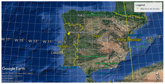
Figure 1.
Location of Macieira de Alcoba, Portugal.
2.2. Data Collection
The Macieira watershed was monitored between 01 November 2010 and 30 September 2014, with continuous measurements of rainfall and other climatic variables, and streamflow and water turbidity at the outlet (Table 1). Observation showed that sediment exportation at the outlet is mainly due to suspended material because bedload is negligible in this site [28]. A fire burned c. 10% of the watershed on 11th August 2011, and about half of the burnt area was clear-cut and ploughed in February and March 2012; therefore, the available data set included two periods: before the fire (2010–2011) and after fire (2012–2014). Outlet data collection was complemented by a survey of linear erosion features composed of rills and ephemeral gullies after major storms, which the resulting volumes of eroded soil converted to mass using bulk density measurements. Furthermore, a characterization of soil texture, depth, hydrological properties (water retention curve, saturated hydraulic conductivity and others), roughness and shear strength, was carried out through a survey at 25 points within the catchment. A more detailed description of data collection can be found in Nunes et al. (2018) [38].

Table 1.
Geomorpological and Hydrological Research Unit (HRU) characterization.
2.3. Model Setup and Calibration Procedure
The LandSoil model (LandSoil: landscape design for soil conservation under land use and climate change) is a spatial raster-based model for simulating water and tillage erosion and landscape topography evolution over time spans on the orders of 10–100 years [39,40]. After simulating each event, LandSoil recalculates the elevation raster. Soil surface properties control water infiltration, runoff and sediment concentration for each grid-cell and rainfall event. As the result of water infiltration balance, runoff is routed over the catchment using a D8 algorithm [41] integrating the upstream/upslope cells contribution and the runoff generated within each cell. Linear landscape elements as ditches and tillage rows are also used to impose preferential directions to the flow [42].
LandSoil can simulate both rill and inter-rill erosion processes. The first is based on factors such as runoff friction and cohesion, topography (slope) and accumulated flow in an empirical relationship with the observed rill sections [43]. The latter, responsible for the remobilization of the soil particles detached by splash erosion, is controlled by the sediment concentration responding to rainfall intensity and soil surface properties such as vegetation cover, soil roughness and soil crusting as declined in expert rules issue of observations at parcel scale [44,45]. In LandSoil, sediment concentration is limited by threshold functions combining local topography, including profile curvature (concavity > 0.055 m−l) and slope gradient (<0.02 mm−), and land use/vegetation cover (>60%). Sediment concentration limits the range from 2.5 to 10 gl−. Tillage erosion is simulated following the formulation of Govers et al. (1994) [46], both contour and downslope were modeled in different fields with tillage transport coefficients spanning from 111 to 139 kgm−g [47].
The implementation of LandSoil on the studied catchment was based on a 2 m resolution grid based on a digital elevation model (DEM) derived from interpolating 1:10,000 contour lines using the ridge line method [48]. The set-up for LandSoil modeling mainly consists on defining the monthly calendars for soil roughness and crusting, vegetation cover, and tillage operation per land use based on a field sampling campaign in 2010 to determine soil texture, chemistry and origin (Table 1, Tables S4–S9). A digital elevation model (DEM) derived from interpolating 1:10,000 contour lines using the ridge line method [48], at 25 m of spatial resolution has been used to represent the catchment topography. In LandSoil, climate forcing is provided through a time series of precipitation events expressed through the effective volume and duration of precipitation, previous precipitation over 48 h and maximum precipitation over five minutes. The calibration of the model was made using events that occurred during the four years monitoring period in a 2-steps procedure: first for runoff, and then for erosion. Calibration for runoff consisted in manually adjusting the soil infiltration parameter. Calibration for erosion consisted in manually adjusting the sediment concentration in runoff and the rill sections. Parameters optimization was based on runoff and sediment exportation at the catchment outlet, as well as field measurements of hydrological soil properties and rill distribution sizes. In LandSoil, soil and land use parameters evolution are provided at a monthly base although simulations are made at the event rainfall base. This choice is consistent with the objective of simulating runoff and erosion over time pans of more than 10 years as it ensures a good representativity of erosion at the catchment scale [49].
All the events generating effective runoff and corresponding to a duration above 3 h, volume above 40 mm and maximum 5-min intensity above 2 mm/h were selected and used in the calibration process. This selection includes both pre- and post-fire events generating together about 90% of the total measured soil erosion. Additionally, in order to inspect a priori the influence of the rainfall factors on runoff and erosion, a regression analysis was performed to relate runoff and SY with rainfall volume, antecedent rainfall, maximum intensity and duration of the event.
2.4. Climate and Fire-Related Scenarios
In this study, climate data were downloaded from the platform Medcordex.eu for both historical (1986–2005) and future (2041–2060) periods. Only the intermediate Representative Concentration Pathway (RCP) 4.5 climate emission scenario [50] was used because differences between RCP scenarios by 2050 were very small. The Regional Climate Model (RCM) ALADIN was chosen in the Mediterranean Agricultural Soils Conservation under global Change (MASCC) project; it was considered as a valid climate model in the comparison of RCM by Fantini et al. (2018) [51]. A statistical downscaling based on a quantile mapping approach was applied on the daily time rainfall series for bias correction, and a temporal downscaling based on an analog approach was then applied to transform the daily rainfall time series into five minutes’ time series. Thus, the 5-min time series have a real temporal structure as a direct result of the observations.
Burnt area scenarios were calculated from climate scenarios according to Sousa et al. (2015) [21]. To this end, the annual burnt area in the region surrounding Macieira (the Águeda river basin) between 1990–2016 was calculated from Portuguese historical databases [13], and a multiple linear regression was calculated with monthly rainfall anomalies, extreme fire weather (days with daily severity rating (DSR) above the 90th percentile [52]) and fire history in the preceding years. Meteorological data was taken from the ECMWF Re-Analysis [53]. While the agreement with observations was not very high (r2 = 0.50), it was sufficient to provide a “best guess” of how much and when the burned area would change for the climate scenarios. Burnt area scenarios under climate change were calculated using rainfall and DSR projections, the latter with a correction for bias using an empirical quantile mapping approach [54]. The estimated doubling of burnt area, reflecting an increase in fire frequency rather than the size of the burnt areas, was more conservative than the three- to four-fold increase obtained with the same methodology for northwestern Iberia [21]. The results for the Águeda were subsequently downscaled for Macieira watershed, by assuming a doubling of fire frequency, from 1× to 2× every 20 years. Fire location was that of the 2011 fire, while the burnt area was the same in all scenarios, except for S2 with 5% larger burn area due to the eucalypt stand in the southern part of the catchment (Figure 2).
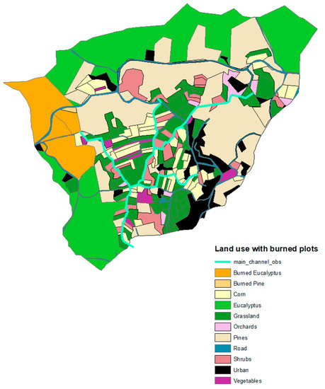
Figure 2.
Location of the burned area in orange in our simulations corresponding to the area that burned in 2011.
2.5. Land Use and Management Scenarios
Four narrative storylines and land use scenarios were used in this study (Figure 3 and Figure 4, Supplementary S1). For this, six local researchers working in different institutions of the Central Portugal NUTS II region (where Macieira is located) were interviewed and completed a survey on writing narrative scenario storylines for four contrasted socio-economics trajectories, initially, designated in the MASCC project: S1 (business-as-usual), S2 (market-oriented), S3 (environmental protection) and S4 (sustainable) in the context of global change in the Caramulo region (Supplementary S1, Tables S1–S3). The survey encompassed a table with future land use distribution, a table with allocation constraints per land use, and a ranking exercise on post-fire soil management rated by local experts. The main elements of the narratives of the four expert-based scenarios are shown in Figure 3.
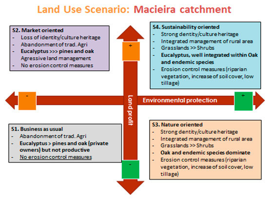
Figure 3.
The four narrative land use scenarios elaborated under the MASCC project and used in this study.
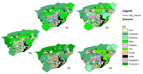
Figure 4.
Land use scenarios.
The current situation (S0) in Macieira is described as that of traditional agriculture (including corn and grassland) that has gradually been abandoned for afforestation, especially with Eucalyptus plantations that now occupy both abandoned agricultural areas and large areas of former pine forest and shrubland (Figure 4). Orchards, although still marginal, are increasing in all our scenarios as being a new profitable production system (berries). In all the scenarios, pine plantation decreases due to low profitability and due to reported increased pests and diseases, while oak is re-introduced in the environmental protection scenario (S3) and the sustainable scenario (S4) for biodiversity conservation and increase in soil water holding capacity, with incentives from local associations and/or government. In the S3 scenario, the maintenance and/or restoration of riparian vegetation is foreseen to capture sediments along the stream (with vegetated strips), in combination with adoption of conservation agriculture with lower tillage intensity. In S4, the same biodiversity and soil protection measures were implemented as in S3 but to only half the extent. In S3 and S4, soil tillage was also adjusted to follow contour lines.
As post-fire management, we selected application of mulch because it was suggested by local-experts as the most cost-effective post-fire conservation measure in this region, which is consistent with the findings of studies in the region [28,29,32,55] as well as in other parts of Iberian Peninsula [56,57].
2.6. Simulation Design
Model simulations concerned the period from 1986 to 2005 as well as a future period of 20 years between 2041 and 2060. They included the simulation of the exhaustive time series of major rainfall events, i.e., rainfall events with a mean lager than 40 mm. First, we assessed the impact of fire frequency and mulch application on runoff and soil erosion (Table 2) and then we assessed the combined impacts of land use and climate change scenarios, following the matrix in (Table 3).

Table 2.
Impact of fire frequency and mulching on runoff and sediment yield (SY) on the baseline scenario S0.

Table 3.
Impact of global change on runoff and sediment yield (SY).
2.7. Data Analysis
The impact of fire frequency, mulch application and changes in climate and land use and management on runoff and erosion were analyzed by comparing the LANDSOIL simulations outputs with R studio software Version 1.0.136. In this paper, three levels of fire frequency were tested (i.e., 0, 1 and 2 fires every 20 years); two levels of mulch application (with or without application); two levels of climate change (with or without) and five scenarios of land use and management (S0 to S4). The simulation of the combinations of factors described in Table 3 and Table 4 permitted to evaluate the distinct and combined impacts of these factors for the 2041–2060 period compared to the 1986–2005 period. A period of 3 post-fire years was also used to analyze the direct impact of fire and related contribution over 20 years. When there was no fire, we calculated the runoff and erosion produced during the period when fire would have had occurred to be able to compare with the period with fire. When two fires occurred, we calculated the runoff and SY that occurred two times: for three years after each fire.

Table 4.
Impact of fire frequency and mulch application on runoff and sediment yield (SY) over 20 years (1986–2005). Control represents «S0 + 1 Fire» in 20 y, ii represents «no fire», iii represents «1 Fire including post-fire mulch application», iv represents «2 Fires» and v represents «2 Fires including post-fire mulch application». Relative values are in italics.
3. Results
3.1. Variable Explaining Runoff and Sediment Yield in Macieira de Alcoba
Multiple linear regression analyses of event-wise runoff volumes (in m3) and SYs (in Mg) gave satisfactory fits. This was especially true for runoff with an R2 of 0.85 as opposed to 0.58 for SY. The best-fitting equations were:
where: Pt is rainfall volume (in mm), PI30 is the maximum 30-min rainfall intensity (in mm.h−1), Pd is the duration of the rainfall event and AP48 is the amount of rainfall over the 48 h preceding the event. The regressions results showed that rainfall and SY were explained best by Pt (p < 0.001), then by AP48 (p < 0.01) and less significantly Pd and PI30 (see Supplementary S1).
3.2. Calibration of Runoff and Sediment Yields Using the LandSoil Model (2010–2014)
The calibration results were obtained from creating two sets of infiltration rates according to the rainfall events (pre-fire and 3 years of post-fire disturbance) and by creating two sets of erosion by calibrating sediment concentration for diffuse erosion and rill dimension according to pre-fire conditions and fire conditions (three years following fire event) based on the observed data. The calibration of 30 events resulted in a satisfactory simulated runoff with R2 of 0.92 and R2 of 0.85 for simulated SY (Figure 5). We observed a better performance of the simulated runoff and sediment yield in the period post-fire than pre-fire however the period before fire had much lower values than after fire. The averages and SD were similar in both periods and variables. The NSE has the total value of 0.91 for runoff and 0.86 for sediment yield (see Supplementary S9).
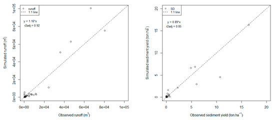
Figure 5.
Results of calibration of LandSoil model for runoff (left plot) and sediment yield (right plot) with observed events between 2010 and 2013. SD stands for sediment yield.
3.3. Impact of Climate Change on Major Precipitation Events
Under the future climate conditions, the total number of major rainfall events over the 20-year period was 5% higher than under present climate conditions. Furthermore, the cumulative rainfall of these events was 7% higher under the future than present climate conditions (Figure 6 and Supplementary S1). At the same time, rainfall duration and maximum intensity, as well as antecedent rainfall, were between 15% and 30% higher under future climate conditions than under the current situation.
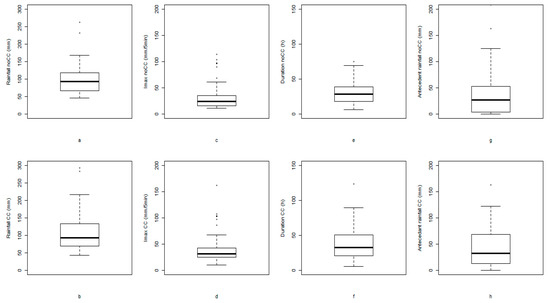
Figure 6.
Boxplots of key characteristics of major rainfall events under present (no climate change—noCC, 1986–2005) and future (climate change—CC, 2041–2060) climate conditions: rainfall total (a,b), maximum intensity over 5 min (c,d), duration (e,f) and antecedent 48 h rainfall (g,h).
3.4. Impacts of Fire Frequency and Post-Fire Mulching on Erosion under Present Climate Conditions
Compared to the control scenario (one fire over the 20 years period 1986–2005), the scenario without fire reduced runoff by 3% over 20 years and by 23% during the 3 years of post-fire disturbance while the scenario with two fires increased runoff by 5% over 20 years and by 153% during the 2 × 3 years of post-fire disturbance (Table 4). In turn, post-fire mulching reduced runoff by 1% and 2% in the case of one and two fires over 20 years, respectively and up to 7% during the post-fire period only. Sediment yield was more strongly affected by fire frequency and post-fire erosion mitigation than runoff. The scenario without fire decreased SY by 33% over the 20 year period (and by 82% during the post-fire period only) compared to the control scenario, while the one with two fires increased it by 28% over the 20 years and by 86% (during the post-fire period only). The scenarios involving post-fire mulch application decreased SY by 16% and 28% in the case of one and two fires, respectively (and by 35% and 40% during the post-fire period only). While with one fire, the years of fire disturbance represents 15% of the runoff generation, when doubling fire frequency, the two periods of fire disturbance generation about 37% of runoff. Concerning SY, under the control situation, the fire disturbance period represents 43% of the SY but when fire frequency doubles, 69% of the sediments are produced during both fire periods (six years out of 20). In the scenario without fire, we showed that during the 3 years when fire would have occurred; only 12% and 15% of runoff and SY were respectively produced. Finally, the contribution of interrill erosion to total erosion accounted for 1%–8% of the total erosion in all the simulations.
3.5. Runoff and Sediment Yield Under Future Climate Conditions
Without changes in fire frequency, cumulative runoff under future climate conditions was 9%–21% higher than under present climate conditions (Table 5, Figure 7 and Figure 8). With a doubling of fire frequency, the cumulative runoff was 13%–25% higher under the future than present climate conditions. The impacts of changes in climate conditions, as well as fire frequency, were most pronounced in the case of the business-as-usual (S1) and market-oriented scenarios (S2). Land use had reduced impacts on runoff under present climate conditions (with differences of up to 3%, in the case of S2) but marked impacts under future climate conditions, with runoff differences amounting to 11%–13% for the S3 and S4 scenarios and to 22%–23% for the S1 and S2 scenarios.

Table 5.
Impact of fire frequency under land use and management and climate change on cumulative runoff and sediment yield (SY) over 20 years. Runoff is in mm and sediment yield in Mg ha−1. The impact is quantified as a percentage of change relative to the control. noCC represents no climate change within the 1986–2005 period and CC represents climate change within the 2041–2060 period.
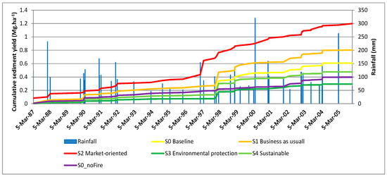
Figure 7.
Cumulative sediment yield (SY) in Mg ha−1 vs. rainfall in mm between 1986 and 2005 with one fire occurrence in 1995.
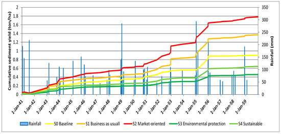
Figure 8.
Cumulative sediment yield (SY) in Mg ha−1 vs. rainfall in mm under climate change between 2041 and 2060 with two fire occurrences in 1941 and 1951.
Concerning sediment yield (Table 5), we observed that the impact of climate change increased SY from 11% (S4 scenario) up to 45% in the S1 scenario under one fire and the impact of increasing fire frequency could increase SY up to 29%. Concerning the impact of land use, we observed high contrasts between scenarios. Without climate change, SY increased from 32% in S1 up to 90% in S2 while we observed a decrease in SY in S3 and S4, respectively by 52% and 21%. The combined impacts of climate change and land use change show an increase of SY by 60% and 126% in S1 and S2 respectively and a decrease by 22% and 47% in S4 and S3 respectively. Land use change and management have a strong impact on SY with nearly a doubling of SY in S2 and a reduction by half in S3 scenario. Figure 9 shows the net cumulative erosion (soil loss) and deposition (soil gain) between 1986 and 2005 for the S2 scenario. Three fields, including two burned fields, show the highest cumulative soil loss between 7 and 9 Mg ha−1, while the areas in the north of the catchment show net deposition probably coming from the road located on the NW of the catchment. In Figure 10, the impact of increasing riparian vegetation in S3 shows the impact of sediment deposition around the stream. Overall, we show that the highest negative impact would be to change the landscape to mainly Eucalyptus plantations with no conservative land management approaches (S2); while with sustainable management (S3) SY can be reduced by half.
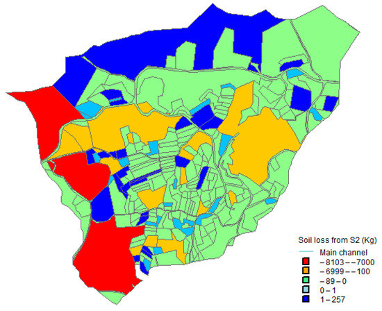
Figure 9.
Soil loss between 1986 and 2005 in S2 after two fires (Kg). Negative values represent soil loss and positive values represent gain.
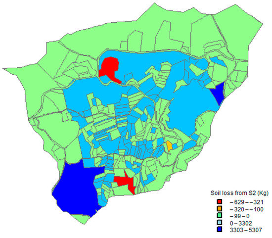
Figure 10.
Soil amount difference between Scenario S3 and S0 without a fire at year 2005 (Kg). Negative values represent loss and positive values represent gain.
4. Discussion
4.1. Application of LandSoil to Macieira
In our study, we found that the volume of rainfall during and 48 h before the fire event was the most important climatic driver of the catchment-scale soil erosion. From these, rainfall volume had the strongest correlation with erosion rates and this can be due to the humid Mediterranean climate in Macieira de Alcoba, with usually bigger and longer events than in drier Mediterranean regions, and concurs with the results of similar other studies in NW Iberia [58]. The calibration of the infiltration rate, sediment concentration and rill dimension led to a good performance of LandSoil in representing current runoff and SY. The only land use that had to be calibrated according to literature was the re-introduction of oak forest, which leads in time to a higher soil water infiltration than Eucalypt [59]). Performance of LandSoil might be improved with an extended field measurement dataset but this would have required more field monitoring and probably another fire occurrence with a different extent and location in the catchment.
4.2. Overall LandSoil Results
The model application to Macieira indicates that the impact of climate change is relatively low, increasing runoff generation by 9% and sediment yield by 19%. Doubling fire frequency has low impacts on runoff in the long-term, increasing by 5%, but larger impacts on SY, which increases by 28%. However, the model also shows the effectiveness of mulch application after fires on SY with a reduction of 16%–28% with one and two fires respectively (and up to 40% reduction during the post-fire disturbance period only). The application of mulch had a lesser impact on runoff than on SY (up 2% reduction) over 20 years and up to 7% during the post-fire disturbance period. Finally, the model indicates that land use change had the lowest impact on runoff, with changes between −1% and 3%, but the largest impacts on SY, changing between −23% and 92%. These results show that land use allocation and management was the most important factor impacting SY with a potential exacerbation of fire and climate change impacts in the case of S1 and S2 scenarios and strong potential of mitigation in S3 and S4 scenarios. In these latter scenarios, a large part of sediments was trapped in riparian fields, therefore preventing sediments to reach the stream and outlet (Figure 10).
This decreased SY more than soil erosion; while this would not mitigate land degradation in burned areas, it would limit stream contamination by ash transport after a fire event, which can have significant impacts on water resources [19]. Compared to the modeling study by Nunes et al. (2018b), our results showed less impact of fire on runoff and SY; while in Nunes et al. (2018a) [60] a ‘no fire situation’ decreases SY by 2/3, in our case SY was decreased by 1/3. This could be due to the duration of the calculated cumulative SY. In Nunes et al. (2018a, b), this is done for a 10-yr period as opposed to for a 20 years period in this study. In fact, when our results were only compared during the three years of post-fire disturbance, the efficiency of mulch application decreased runoff by 7% and SY by 40%. Compared to Prats et al. (2019, 2012) where mulch application reduced runoff by 15%–25% and SY by more than five times, our results were more conservative probably because our burnt field area only represented 10% of the watershed area; while Prats et al. (2012, 2019) calculated SY at the field area scale and they burned 100% of the area while in our case 10% of the catchment burned. Moreover, our simulations ran over 20 years vs. 5–10 years in other studies [32,61].
Our study shows the low impact of mulch application on runoff generation. This could be due to high soil water repellency in the eucalypt burnt forest. Soil water repellency also exists in Eucalyptus forests and in a pre-fire situation due to preponderant ligneous root materials compared to oak and pine trees [59,62]. However, soil water repellency has a limited impact on runoff generation, in the early autumn [61]; and this is only important for patches since at the hillslope scale there are always non-repellent zones where water can re-infiltrate [15]. The low impact of mulching on runoff reduction is also probably due to the low total amount of runoff generation in both burnt and unburnt eucalypt plantations, at least at the hillslope scale [15,37]. Finally, the risk of increasing floods remains relatively low compared to predicted extreme rainfall events [60] due to the low impact of fires on runoff production.
Concerning sediment reduction caused by mulching, Shakesby et al. (1996) [63], showed that Eucalyptus logging litter reduced soil erosion by 95%. The average reduction was five times in Prats et al. (2019, 2012); it should be noted that, in the latter study, maximum erosion rates were lower than in our study site. As previously said, the study site of Prats et al. (2012) also presents smaller temporal and spatial scales. In our study, mulch could reduce SY by up to 40%, which was quite high considering that fire only impacted roughly 10% of the watershed. We also suggest that these values vary with the type and quantity of mulch that is applied, the soil type, the percentage of soil cover and the slope of the site (Prats et al., 2014, 2012). Finally, Figure 5 and Figure 6 show that erosion was mainly a raindrop-driven process with the detachment of sediments in eucalypt forest and some tilled field. The highest levels of soil loss occurred in the burnt field area and in one field with a slope above 10° in the S2 scenario (about 7–8 Mg per parcel) and these three areas contribute to 37% of total soil loss in scenario S2 (Figure 7 and Figure 8). The combined impact of fire on SY at the outlet and the spatial representation of soil loss coming from burned areas show that erosion was mainly due to soil detachment rather than transported by water to the outlet via sedimentation on the riparian field close to the stream and in the terraces.
4.3. Distinct and Combined Impacts of Global Change and Fire Frequency
In light of future climate change, it is likely that fire frequency could increase in a context of climate change and that doubling fire frequency might be conservative in our study when compared with burned area projections for this region [21]. The land use scenarios might also impact fire frequency and extent; for example, the increase of Eucalyptus plantation and intensification in S1 and S2 might exacerbate the risk of fire occurrence and propagation, while in S3 and S4 the adoption of crop diversification and protective land use and management should lead to lower risks of fires and erosion. However, we did not take these differences into account because we wanted to have the same number of fires in our land use scenarios so the specific impact of fire would be comparable. In any case, our results show that fire frequency had a larger impact on soil erosion (up to 33% change) than on runoff generation (up to 5% change). In addition, our results also show 43% of the erosion was produced during 3 years after the fire event representing 15% of the duration of the simulation (Table 4). This concurred with multiple studies, which showed that the indirect impacts of climate change, such as associated changes to land use and fire occurrence can have larger impacts than those of changes to climatic variables alone [9,64,65,66]. In the fire-prone forests of NW Iberia, efforts to limit the impact of climate change on land degradation should, therefore, focus on fire prevention and post-fire impact mitigation.
4.4. Status of Post Fire Measures Implementation
Our study shows the potential of using soil management measures to mitigate post-fire erosion in NW Portugal with a mix of numerical modeling and field experiments. The biophysical effectiveness of erosion control measures is well understood in NW Portugal [67,68]. Studies show the high performance of mulching and erosion control barriers, and the lesser effectiveness of erosion control measures such as post-fire seedling, which are more difficult to manage due to the time lag of seed germination and the availability of native seeds [69]. However, there is currently only one study calculating the costs of post-fire control erosion measures [68]. The benefits produced by controlling overland runoff and SY with control erosion measures on hydrological services should be biophysically and economically quantified so that implementation of erosion control measures can be communicated at the science-policy management level [70]. For instance, the risk of water contamination must be studied and costs of prevention (with erosion control measures) compared to the costs of water treatment must be evaluated [18,60,71,72]. The same applies to the hydrological service of flood regulation and enhanced water soil content and fertility with post-fire erosion control measures via increased soil organic matter, soil aggregate stability and nutrient availability [73]. For this work to proceed, more studies are needed on the socio-economic aspects of fire prevention and post-fire contamination control.
5. Conclusions
This study evaluated the potential impacts of global change and fire frequency on water runoff and soil erosion. The novelty of this study lies with the assessment of global change with field and landscape conservation management techniques such as application of mulch in post-fire conditions, implementation of vegetated strips (or restoration of riparian vegetation) and decreased soil tillage on water runoff and soil erosion. Our results show that the LandSoil model performed well for runoff and SY compared to the observed data of 2010–2014 and that rainfall volumes (>40 mm) during and 48 h before fire occurrence are the main climate drivers of soil erosion before rainfall duration and maximum intensity. With LandSoil we could test contrasted land use scenarios including Eucalyptus intensification to show their potential risk of implementation under global change (up to +98% in SY in the market-oriented (S2) scenario) while a conservation scenario including environmental protection and afforestation of local species can decrease soil erosion by half. The application of mulching was an effective tool against erosion (up to 28% with two fires in 20 years). Finally, preventing fire is also a potential erosion mitigation tool with a decrease of 33% of soil erosion. Valuating hydrological services of post-fire erosion measures would clarify the feasibility of implementation of these latter by communicating the results within a science-policy interface in a context of the latest Intergovernmental Panel on Climate Change (IPCC) recommendations on achieving climate change mitigation and land degradation neutrality (LDN).
Supplementary Materials
The following are available online at https://www.mdpi.com/2073-4441/11/12/2617/s1, Supplementary S1: Narrative Storyline of Land Use Scenario of MASCC Project, Supplementary S2: Land Use and Climate Scenarios. Table S1: Land use allocation constrains for Macieira, Table S2: Land use allocation per scenario S0 (baseline 2000), S1, S2, S3 and S4, Table S3. Soil conservation practices ranking by six local experts during MASCC project, Table S4: Statistical summary of rainfall events selected on the study site during the period 1986–2005 (noCC) and 2041–2060 (CC), Supplementary S3: Results from Statistical Analyses of Observed Rainfall Events and Corresponding Runoff and Sediment Yield (R version 3.4.2 (28 September 2017)—“Short Summary”), Supplementary S4: Table S4: Calibration of Monthly Calendars of Soil Roughness, Soil Crusting and Soil Cover per Land Use, Supplementary S5: Soil Tillage Calibration, Supplementary S6: LandSoil Turbidity Calibration, Supplementary S7: Calibration of Rill Erosion, Supplementary S8: Calibration of Infiltration Rates for Two Periods (Pre-Fire and during the Fire Disturbance Period), Supplementary S9: Results from the Calibration of Runoff and Sediment Yield in Pre and Post Fire Periods. Figure S1: Difference in elevation change between scenario S3 and S0 without fire occurrence. Figure S2: Elevation change in scenario S2 between 2000 and 2050.
Author Contributions
Conceptualization: A.V.P., J.P.N., R.C., Y.L.-B., J.J.K. and D.R.; Formal analysis: A.V.P., J.P.N., M.K. and F.H.; Funding acquisition: T.C. and D.R.; Investigation: J.P.N., Y.L.-B., J.J.K. and D.R.; Methodology, A.V.P., J.B., F.H., T.C., Y.L.-B. and D.R.; Software: R.C. and M.K.; Supervision: J.P.N., J.B. and Y.L.-B.; Validation: J.P.N. and D.R.; Visualization: A.V.P.; Writing—original draft: A.V.P., J.P.N., D.R.; Writing—review & editing, J.P.N., R.C., M.K., J.B., F.H., T.C., J.J.K. and D.R.
Funding
This work benefits from the financial support of the MASCC project through ARIMNET2, an ERA-NET funded by the European Union′s Seventh Framework Program for research, technological development and demonstration under grant agreement no. 618127. APV was funded by the MASCC project described above. This work was further funded by the “Fundação para a Ciência e a Tecnologia”, with personal grants attributed to J.P. Nunes (IF/00586/2015) and J.J. Keizer (IF/01465/2015), and funding for data collection in Macieira within project ERLAND (FCOMP-01-0124-FEDER-008534). J. Baartman visited the site with funding from an STSM mission within the Connecteur COST Action ES1306. M. Koopmans was partly funded by ERASMUS+.
Acknowledgments
We would like to thank the two external reviewers and the editorial board for their valuable comments before the acceptance of the manuscript.
Conflicts of Interest
The authors declare no conflict of interest.
References
- Lal, R. Accelerated soil erosion as a source of atmospheric CO2. Soil Tillage Res. 2019, 188, 35–40. [Google Scholar] [CrossRef]
- Walker, B. Global change extensive strategy agriculture options in the regions of the world. Clim. Chang. 1994, 27, 39–47. [Google Scholar] [CrossRef]
- Montgomery, D.R. Soil erosion and agricultural sustainability. Proc. Natl. Acad. Sci. USA 2007, 104, 13268–13272. [Google Scholar] [CrossRef] [PubMed]
- Vanmaercke, M.; Poesen, J.; Verstraeten, G.; de Vente, J.; Ocakoglu, F. Sediment yield in Europe: spatial patterns and scale dependency. Geomorphology 2011, 130, 142–161. [Google Scholar] [CrossRef]
- Woodward, J.C. Patterns of Erosion and Suspended Sediment Yield in Mediterranean River Basins; Wiley: Chichester, UK, 1995. [Google Scholar]
- Cerdan, O.; Govers, G.; Le Bissonnais, Y.; Van Oost, K.; Poesen, J.; Saby, N.; Gobin, A.; Vacca, A.; Quinton, J.; Auerswald, K. Rates and spatial variations of soil erosion in Europe: a study based on erosion plot data. Geomorphology 2010, 122, 167–177. [Google Scholar] [CrossRef]
- Panagos, P.; Borrelli, P.; Meusburger, K.; Alewell, C.; Lugato, E.; Montanarella, L. Estimating the soil erosion cover-management factor at the European scale. Land Use Policy 2015, 48, 38–50. [Google Scholar] [CrossRef]
- De Franchis, L.; Bleu, P.; Ibanez, F. Threats to Soils in Mediterranean Countries: Document Review; PAM, Plan Bleu: Sophia-Antipolis, France, 2003. [Google Scholar]
- Raclot, D.; Le Bissonnais, Y.; Annabi, M.; Sabir, M.; Smetanova, A. Main issues for preserving Mediterranean soil resources from water erosion under global change. L. Degrad. Dev. 2018, 29, 789–799. [Google Scholar] [CrossRef]
- García-Ruiz, J.M.; Nadal-Romero, E.; Lana-Renault, N.; Beguería, S. Erosion in Mediterranean landscapes: changes and future challenges. Geomorphology 2013, 198, 20–36. [Google Scholar] [CrossRef]
- Shakesby, R.A. Post-wildfire soil erosion in the Mediterranean: review and future research directions. Earth Sci. Rev. 2011, 105, 71–100. [Google Scholar] [CrossRef]
- Batllori, E.; Parisien, M.; Krawchuk, M.A.; Moritz, M.A. Climate change-induced shifts in fire for Mediterranean ecosystems. Glob. Ecol. Biogeogr. 2013, 22, 1118–1129. [Google Scholar] [CrossRef]
- Pereira, M.G.; Malamud, B.D.; Trigo, R.M.; Alves, P.I. The history and characteristics of the 1980–2005 Portuguese rural fire database. Nat. Hazards Earth Syst. Sci. 2011, 11, 3343–3358. [Google Scholar] [CrossRef]
- Doerr, S.H.; Santín, C. Global trends in wildfire and its impacts: perceptions versus realities in a changing world. Philos. Trans. R. Soc. B Biol. Sci. 2016, 371, 20150345. [Google Scholar] [CrossRef] [PubMed]
- Ferreira, A.J.D.; Coelho, C.O.A.; Ritsema, C.J.; Boulet, A.K.; Keizer, J.J. Soil and water degradation processes in burned areas: lessons learned from a nested approach. Catena 2008, 74, 273–285. [Google Scholar] [CrossRef]
- Ferreira, A.J.D.; Alegre, S.P.; Coelho, C.O.A.; Shakesby, R.A.; Páscoa, F.M.; Ferreira, C.S.S.; Keizer, J.J.; Ritsema, C. Strategies to prevent forest fires and techniques to reverse degradation processes in burned areas. Catena 2015, 128, 224–237. [Google Scholar] [CrossRef]
- Campos, I.; Abrantes, N.; Pereira, P.; Keizer, J.J. Chap. 9. Polycyclic aromatic hydrocarbons; Pereira, P., Mataix-Solera, J., Úbeda, X., Rein, G., Cerda, A., Eds.; CSIRO PUBLISHING: Sydney, Australia, 2019. [Google Scholar]
- Nunes, B.; Silva, V.; Campos, I.; Pereira, J.L.; Pereira, P.; Keizer, J.J.; Gonçalves, F.; Abrantes, N. Off-site impacts of wildfires on aquatic systems—biomarker responses of the mosquitofish Gambusia holbrooki. Sci. Total Environ. 2017, 581, 305–313. [Google Scholar] [CrossRef]
- Nunes, J.P.; Naranjo Quintanilla, P.; Santos, J.M.; Serpa, D.; Carvalho-Santos, C.; Rocha, J.; Keizer, J.J.; Keesstra, S.D. Afforestation, subsequent forest fires and provision of hydrological services: A model-based analysis for a Mediterranean mountainous catchment. Land Degrad. Dev. 2018, 29, 776–788. [Google Scholar] [CrossRef]
- Bedia, J.; Herrera, S.; Gutiérrez, J.M.; Benali, A.; Brands, S.; Mota, B.; Moreno, J.M. Global patterns in the sensitivity of burned area to fire-weather: Implications for climate change. Agric. For. Meteorol. 2015, 214, 369–379. [Google Scholar] [CrossRef]
- Sousa, P.M.; Trigo, R.M.; Pereira, M.G.; Bedia, J.; Gutiérrez, J.M. Different approaches to model future burnt area in the Iberian Peninsula. Agric. For. Meteorol. 2015, 202, 11–25. [Google Scholar] [CrossRef]
- Barbero, R.; Abatzoglou, J.T.; Larkin, N.K.; Kolden, C.A.; Stocks, B. Climate change presents increased potential for very large fires in the contiguous United States. Int. J. Wildl. Fire 2015, 24, 892–899. [Google Scholar] [CrossRef]
- Wang, X.; Thompson, D.K.; Marshall, G.A.; Tymstra, C.; Carr, R.; Flannigan, M.D. Increasing frequency of extreme fire weather in Canada with climate change. Clim. Chang. 2015, 130, 573–586. [Google Scholar] [CrossRef]
- Liu, Z.; Wimberly, M.C. Direct and indirect effects of climate change on projected future fire regimes in the western United States. Sci. Total Environ. 2016, 542, 65–75. [Google Scholar] [CrossRef] [PubMed]
- Syphard, A.D.; Sheehan, T.; Rustigian-Romsos, H.; Ferschweiler, K. Mapping future fire probability under climate change: Does vegetation matter? PLoS ONE 2018, 13, e0201680. [Google Scholar] [CrossRef] [PubMed]
- Fernández, C.; Vega, J.A. Evaluation of RUSLE and PESERA models for predicting soil erosion losses in the first year after wildfire in NW Spain. Geoderma 2016, 273, 64–72. [Google Scholar] [CrossRef]
- Ferreira, V.; Panagopoulos, T. Seasonality of Soil Erosion Under Mediterranean Conditions at the Alqueva Dam Watershed. Environ. Manag. 2014, 54, 67–83. [Google Scholar] [CrossRef] [PubMed]
- Keizer, J.J.; Silva, F.C.; Vieira, D.C.S.; González-Pelayo, O.; Campos, I.; Vieira, A.M.D.; Valente, S.; Prats, S.A. The effectiveness of two contrasting mulch application rates to reduce post-fire erosion in a Portuguese eucalypt plantation. Catena 2018, 169, 21–30. [Google Scholar] [CrossRef]
- Prats, S.A.; Malvar, M.C.; Vieira, D.C.S.; MacDonald, L.; Keizer, J.J. Effectiveness of Hydromulching to Reduce Runoff and Erosion in a Recently Burnt Pine Plantation in Central Portugal. Land Degrad. Dev. 2016, 27, 1319–1333. [Google Scholar] [CrossRef]
- Gómez-Rey, M.X.; Couto-Vázquez, A.; García-Marco, S.; Vega, J.A.; González-Prieto, S.J. Reduction of nutrient losses with eroded sediments by post-fire soil stabilisation techniques. Int. J. Wildl. Fire 2013, 22, 696–706. [Google Scholar] [CrossRef]
- Prats, S.A.; González-Pelayo, Ó.; Silva, F.C.; Bokhorst, K.J.; Baartman, J.E.M.; Keizer, J.J. Post-fire soil erosion mitigation at the scale of swales using forest logging residues at a reduced application rate. Earth Surf. Process. Landf. 2019. [Google Scholar] [CrossRef]
- Prats, S.A.; MacDonald, L.H.; Monteiro, M.; Ferreira, A.J.D.; Coelho, C.O.A.; Keizer, J.J. Effectiveness of forest residue mulching in reducing post-fire runoff and erosion in a pine and a eucalypt plantation in north-central Portugal. Geoderma 2012, 191, 115–124. [Google Scholar] [CrossRef]
- Robichaud, P.R.; Ashmun, L.E.; Sims, B.D. Post-Fire Treatment Effectiveness for Hillslope Stabilization; General Technical Report RMRS-GTR-240; US Department of Agriculture, Forest Service, Rocky Mountain Research Station: Fort Collins, CO, USA, 2010.
- Vega, J.A. Acciones urgentes contra la erosión en áreas forestales quemadas: Guía para su planificación en Galicia; INIA. Xunt.; Andavira: Santiago de Compostela, Spain, 2013; ISBN 8484087166. [Google Scholar]
- Hosseini, M.; Keizer, J.J.; Pelayo, O.G.; Prats, S.A.; Ritsema, C.; Geissen, V. Effect of fire frequency on runoff, soil erosion, and loss of organic matter at the micro-plot scale in north-central Portugal. Geoderma 2016, 269, 126–137. [Google Scholar] [CrossRef]
- Ferreira, C.G. Erosão Hídrica em Solos Florestais. Estudo em povoamentos de Pinus pinaster e Eucalyptus globulus em Macieira de Alcoba. 1996. Available online: http://www.dcs.ufla.br/site/_adm/upload/file/pdf/Prof%20Marx/Aula%205/Outro%20art%20interesse/Ferreira%201996_erosao%20em%20floresta.pdf (accessed on 10 December 2019).
- Hawtree, D.; Nunes, J.P.; Keizer, J.J.; Jacinto, R.; Santos, J.; Rial-Rivas, M.E.; Boulet, A.-K.; Tavares-Wahren, F.; Feger, K.-H. Time series analysis of the long-term hydrologic impacts of afforestation in the Águeda watershed of north-central Portugal. Hydrol. Earth Syst. Sci. 2015, 19, 3033–3045. [Google Scholar] [CrossRef]
- Nunes, J.P.; Bernard-Jannin, L.; Rodríguez Blanco, M.L.; Santos, J.M.; Coelho, C.O.A.; Keizer, J.J. Hydrological and erosion processes in terraced fields: observations from a humid Mediterranean region in Northern Portugal. Land Degrad. Dev. 2018, 29, 596–606. [Google Scholar] [CrossRef]
- Ciampalini, R.; Follain, S.; Cheviron, B.; Le Bissonnais, Y.; Couturier, A.; Moussa, R.; Walter, C. Local Sensitivity Analysis of the LandSoil Erosion Model Applied to a Virtual Catchment. In Sensitivity Analysis in Earth Observation Modelling; Elsevier: Wales, UK, 2017; pp. 55–73. [Google Scholar]
- Ciampalini, R.; Follain, S.; Le Bissonnais, Y. LandSoil: a model for analysing the impact of erosion on agricultural landscape evolution. Geomorphology 2012, 175, 25–37. [Google Scholar] [CrossRef]
- Jenson, S.K.; Domingue, J.O. Extracting topographic structure from digital elevation data for geographic information system analysis. Photogramm. Eng. Remote Sens. 1988, 54, 1593–1600. [Google Scholar]
- Souchere, V.; King, D.; Daroussin, J.; Papy, F.; Capillon, A. Effects of tillage on runoff directions: consequences on runoff contributing area within agricultural catchments. J. Hydrol. 1998, 206, 256–267. [Google Scholar] [CrossRef]
- Souchere, V.; Cerdan, O.; Ludwig, B.; Le Bissonnais, Y.; Couturier, A.; Papy, F. Modelling ephemeral gully erosion in small cultivated catchments. Catena 2003, 50, 489–505. [Google Scholar] [CrossRef]
- Cerdan, O.; Le Bissonnais, Y.; Couturier, A.; Saby, N. Modelling interrill erosion in small cultivated catchments. Hydrol. Process. 2002, 16, 3215–3226. [Google Scholar] [CrossRef]
- Cerdan, O.; Souchère, V.; Lecomte, V.; Couturier, A.; Le Bissonnais, Y. Incorporating soil surface crusting processes in an expert-based runoff model: sealing and transfer by runoff and erosion related to agricultural management. Catena 2002, 46, 189–205. [Google Scholar] [CrossRef]
- Govers, G.; Vandaele, K.; Desmet, P.; Poesen, J.; Bunte, K. The role of tillage in soil redistribution on hillslopes. Eur. J. Soil Sci. 1994, 45, 469–478. [Google Scholar] [CrossRef]
- Van Muysen, W.; Govers, G.; Van Oost, K.; Van Rompaey, A. The effect of tillage depth, tillage speed, and soil condition on chisel tillage erosivity. J. Soil Water Conserv. 2000, 55, 355–364. [Google Scholar]
- Hutchinson, M.F.; Xu, T.; Stein, J.A. Recent progress in the ANUDEM elevation gridding procedure. Geomorphometry 2011, 2011, 19–22. [Google Scholar]
- Nunes, J.P.; Nearing, M.A. Modelling impacts of climatic change: case studies using the new generation of erosion models. Handbook of Erosion Modelling; John Wiley & Sons, Ltd.: Hoboken, NJ, USA, 2011; pp. 289–312. [Google Scholar]
- Van Vuuren, D.P.; Edmonds, J.; Kainuma, M.; Riahi, K.; Thomson, A.; Hibbard, K.; Hurtt, G.C.; Kram, T.; Krey, V.; Lamarque, J.-F. The representative concentration pathways: an overview. Clim. Chang. 2011, 109, 5–31. [Google Scholar] [CrossRef]
- Fantini, A.; Raffaele, F.; Torma, C.; Bacer, S.; Coppola, E.; Giorgi, F.; Ahrens, B.; Dubois, C.; Sanchez, E.; Verdecchia, M. Assessment of multiple daily precipitation statistics in ERA-Interim driven Med-CORDEX and EURO-CORDEX experiments against high resolution observations. Clim. Dyn. 2018, 51, 877–900. [Google Scholar] [CrossRef]
- Van Wagner, C.E. Development and Structure of the Canadian Forest Fire Weather Index System; Canadian Forestry Service: Ottawa, ON, Canada, 1987; Volume 35, ISBN 0662151984.
- Berrisford, P.; Dee, D.P.; Poli, P.; Brugge, R.; Fielding, M.; Fuentes, M.; Kallberg, P.W.; Kobayashi, S.; Uppala, S.; Simmons, A. The ERA-Interim archive Version 2.0; ECMWF: Reading, UK, 2011. [Google Scholar]
- Gudmundsson, L.; Bremnes, J.B.; Haugen, J.E.; Engen-Skaugen, T. Downscaling RCM precipitation to the station scale using statistical transformations–a comparison of methods. Hydrol. Earth Syst. Sci. 2012, 16, 3383–3390. [Google Scholar] [CrossRef]
- Prats, S.; Malvar, M.; Martins, M.A.S.; Keizer, J.J. Post-fire soil erosion mitigation: a review of the last research and techniques developed in Portugal. Cuad. Investig. Geográfica 2014, 40, 403–428. [Google Scholar] [CrossRef]
- Badia, D.; Marti, C. Seeding and mulching treatments as conservation measures of two burned soils in the central ebro valley, ne spain. Arid Soil Res. Rehabil. 2000, 14, 219–232. [Google Scholar] [CrossRef]
- Fernández, C.; Vega, J.A. Are erosion barriers and straw mulching effective for controlling soil erosion after a high severity wildfire in NW Spain? Ecol. Eng. 2016, 87, 132–138. [Google Scholar] [CrossRef]
- Rodriguez-Blanco, M.L.; Taboada-Castro, M.M.; Palleiro, L.; Taboada-Castro, M.T. Assessment of the effects of rainfall variability on the hydrological regime of a small rural catchment in Northwest Spain: preliminary results. In Proceedings of the EGU General Assembly Conference Abstracts, Vienna, Austria, 2–7 May 2010; Volume 12, p. 14227. [Google Scholar]
- Alves, A.M. O eucaliptal em Portugal: impactes ambientais e investigação cientifica; Univ. Técnica, Inst. Superior de Agronomia: Lisbon, Portugal, 2007; ISBN 9728669259. [Google Scholar]
- Nunes, J.P.; Doerr, S.H.; Sheridan, G.; Neris, J.; Santín, C.; Emelko, M.B.; Silins, U.; Robichaud, P.R.; Elliot, W.J.; Keizer, J. Assessing water contamination risk from vegetation fires: challenges, opportunities and a framework for progress. Hydrol. Process. 2018. [Google Scholar] [CrossRef]
- Malvar, M.C.; Silva, F.C.; Prats, S.A.; Vieira, D.C.S.; Coelho, C.O.A.; Keizer, J.J. Short-term effects of post-fire salvage logging on runoff and soil erosion. For. Ecol. Manag. 2017, 400, 555–567. [Google Scholar] [CrossRef]
- Santos, R.M.B.; Sanches Fernandes, L.F.; Pereira, M.G.; Cortes, R.M.V.; Pacheco, F.A.L. A framework model for investigating the export of phosphorus to surface waters in forested watersheds: Implications to management. Sci. Total Environ. 2015, 536, 295–305. [Google Scholar] [CrossRef] [PubMed]
- Shakesby, R.A.; Boakes, D.J.; Coelho, C.O.A.; Gonçalves, A.J.B.; Walsh, R.P.D. Limiting the soil degradational impacts of wildfire in pine and eucalyptus forests in Portugal: a comparison of alternative post-fire management practices. Appl. Geogr. 1996, 16, 337–355. [Google Scholar] [CrossRef]
- Li, Z.; Fang, H. Impacts of climate change on water erosion: A review. Earth-Sci. Rev. 2016, 163, 94–117. [Google Scholar] [CrossRef]
- Paroissien, J.-B.; Darboux, F.; Couturier, A.; Devillers, B.; Mouillot, F.; Raclot, D.; Le Bissonnais, Y. A method for modeling the effects of climate and land use changes on erosion and sustainability of soil in a Mediterranean watershed (Languedoc, France). J. Environ. Manag. 2015, 150, 57–68. [Google Scholar] [CrossRef]
- Smetanová, A.; Nunes, J.; Symenoakis, E.; Brevik, E.; Schindelwolf, M.; Ciampalini, R. Mapping and modelling soil erosion to address societal challenges in a changing world. Land Degrad. Dev. 2019. [Google Scholar] [CrossRef]
- De Figueiredo, T.; Fonseca, F.; Lima, E.; Fleischfresser, L.; Hernandez, Z. Assessing Performance of Post-Fire Hillslope Erosion Control Measures Designed for Different Implementation Scenarios in NE Portugal: Simulations Applying USLE; Nova Scien.: Bragança, Portugal, 2017. [Google Scholar]
- Prats, S.A.; Wagenbrenner, J.W.; Martins, M.A.S.; Malvar, M.C.; Keizer, J.J. Mid-term and scaling effects of forest residue mulching on post-fire runoff and soil erosion. Sci. Total Environ. 2016, 573, 1242–1254. [Google Scholar] [CrossRef]
- Prats, S.A.; dos Santos Martins, M.A.; Malvar, M.C.; Ben-Hur, M.; Keizer, J.J. Polyacrylamide application versus forest residue mulching for reducing post-fire runoff and soil erosion. Sci. Total Environ. 2014, 468, 464–474. [Google Scholar] [CrossRef]
- Brauman, K.A.; Daily, G.C.; Duarte, T.K.; Mooney, H.A. The nature and value of ecosystem services: An overview highlighting hydrologic services. Annu. Rev. Environ. Resour. 2007, 32, 67–98. [Google Scholar] [CrossRef]
- Jones, O.D.; Nyman, P.; Sheridan, G.J. A stochastic coverage model for erosion events caused by the intersection of burnt forest and convective thunderstorms. In Proceedings of the MODSIM 2011—19th International Congress on Modelling and Simulation—Sustaining Our Future: Understanding and Living with Uncertainty, Perth, Australia, 12–16 December 2011; pp. 2338–2344. [Google Scholar]
- Lopes, A.F.; Macdonald, J.L.; Quinteiro, P.; Arroja, L.; Carvalho-Santos, C.; Cunha-e-Sá, M.A.; Dias, A.C. Surface vs. groundwater: The effect of forest cover on the costs of drinking water. Water Resour. Econ. 2019, 28, 100123. [Google Scholar] [CrossRef]
- Mulumba, L.N.; Lal, R. Mulching effects on selected soil physical properties. Soil Tillage Res. 2008, 98, 106–111. [Google Scholar] [CrossRef]
© 2019 by the authors. Licensee MDPI, Basel, Switzerland. This article is an open access article distributed under the terms and conditions of the Creative Commons Attribution (CC BY) license (http://creativecommons.org/licenses/by/4.0/).