Contribution of the Amazon River Discharge to Regional Sea Level in the Tropical Atlantic Ocean

 ,
,  , ,
, , 
Abstract
1. Introduction
2. Materials and Methods
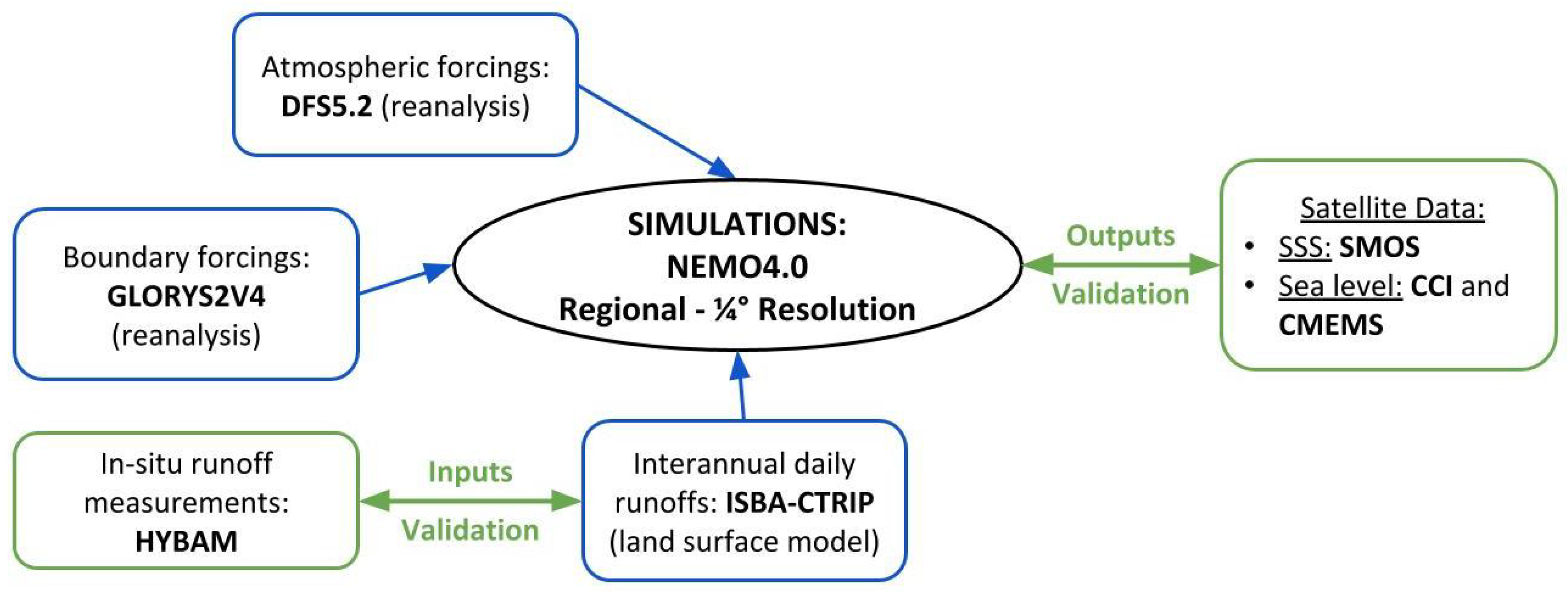
2.1. Model Configuration
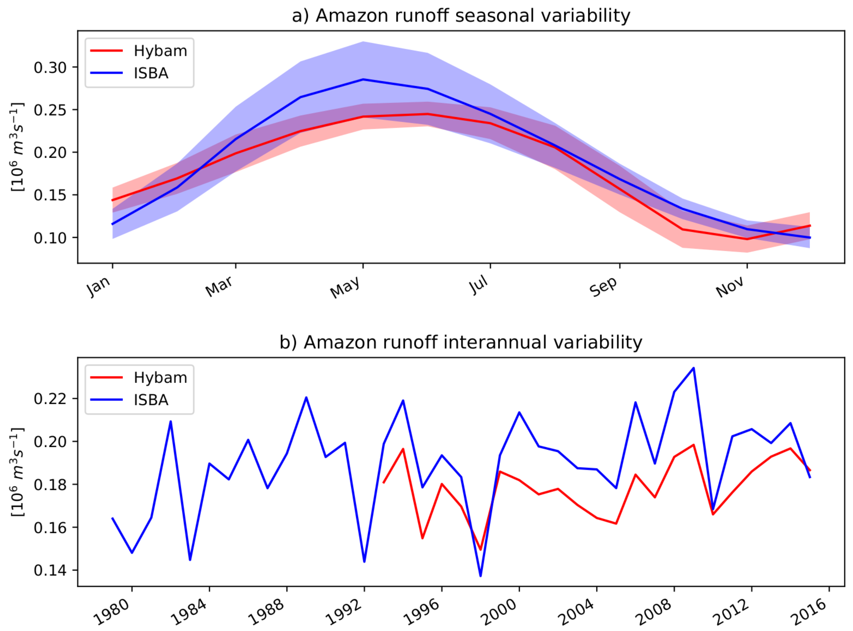
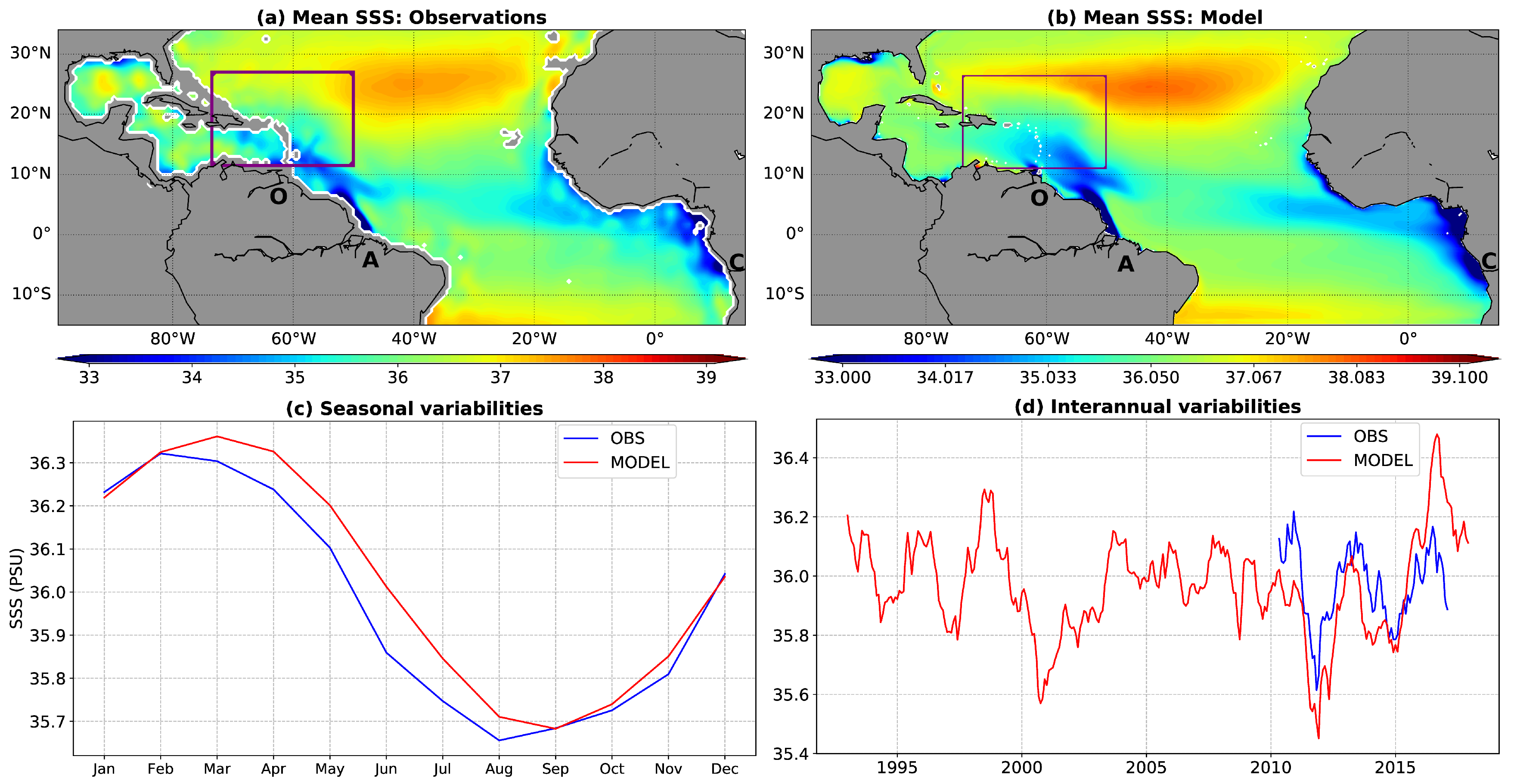
2.2. Data and Products
2.3. Methods
2.4. Model-Observation Comparisons
3. Results and Discussions
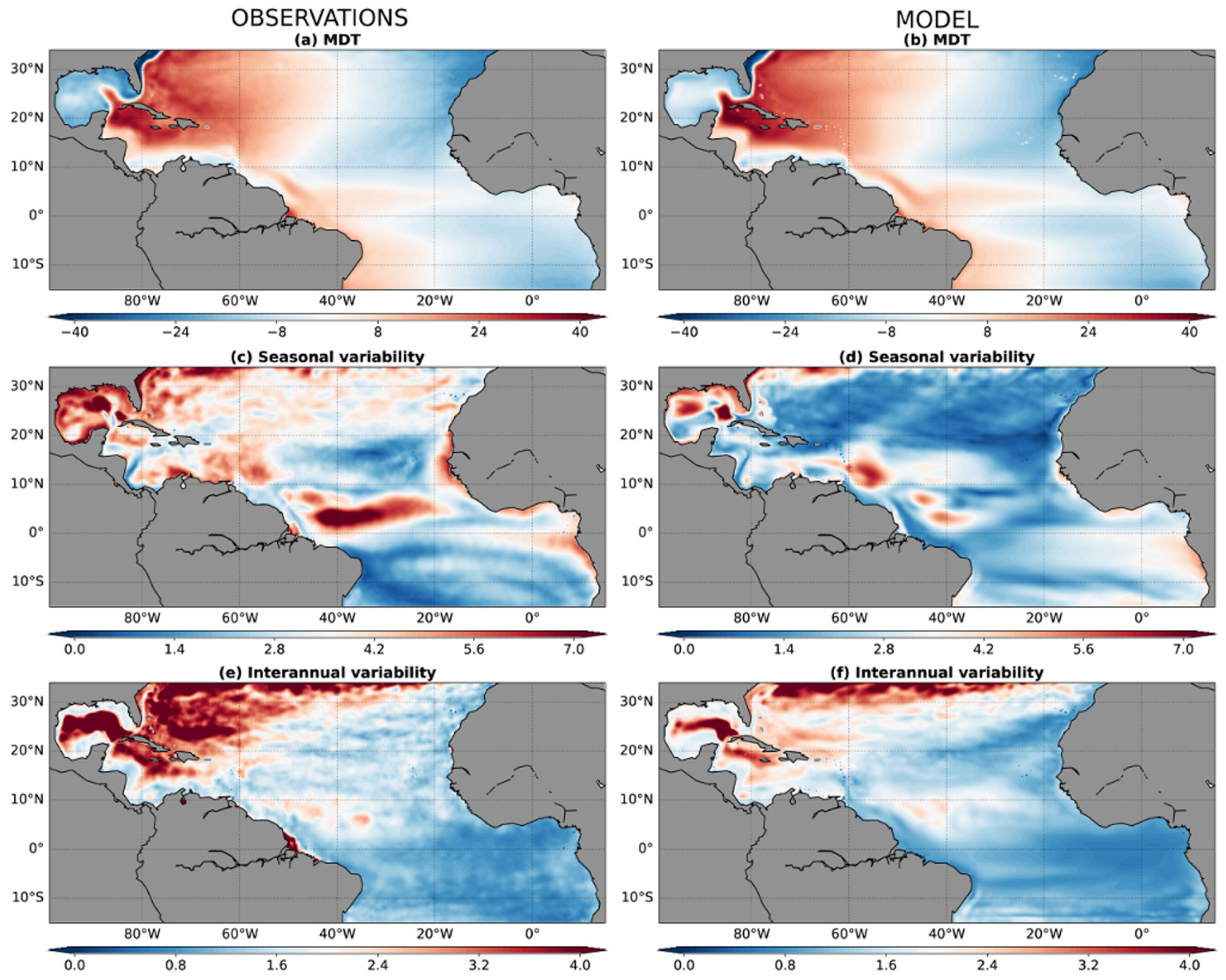
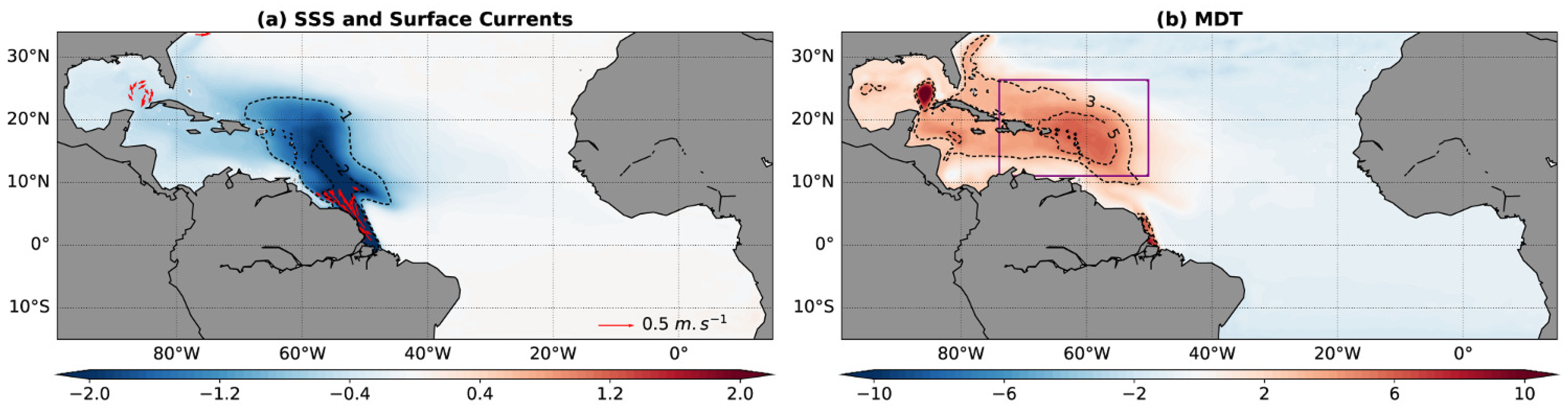
3.1. Mean State of Sea Level
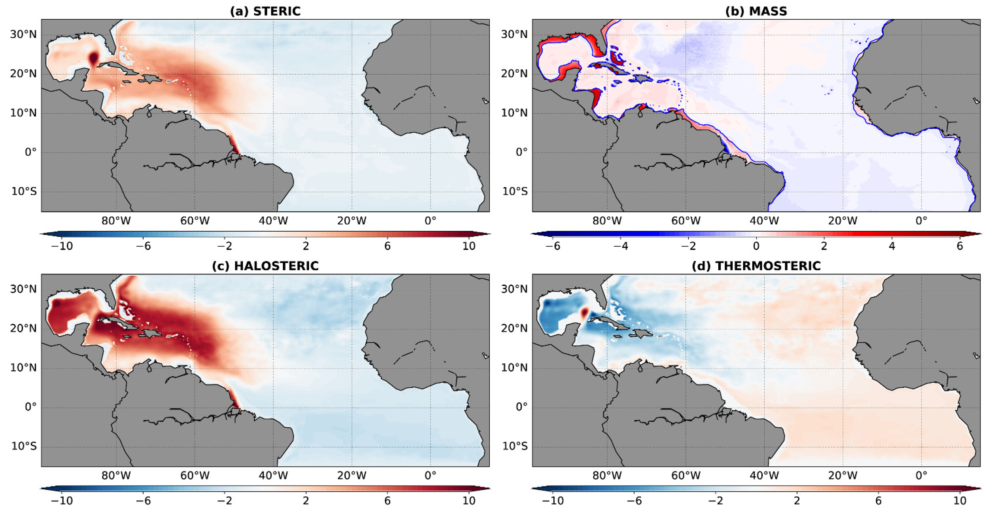
3.2. Temperature, Salinity and Manometric Contributions to Regional Mean-State Sea Level
3.3. Seasonal and Interannual Sea Level Variability
4. Conclusions
- The Mean Dynamic Topography (MDT) is up to 11 cm higher at the Amazon mouth with Amazon runoff and 3.3 cm higher around the Caribbean Archipelago.
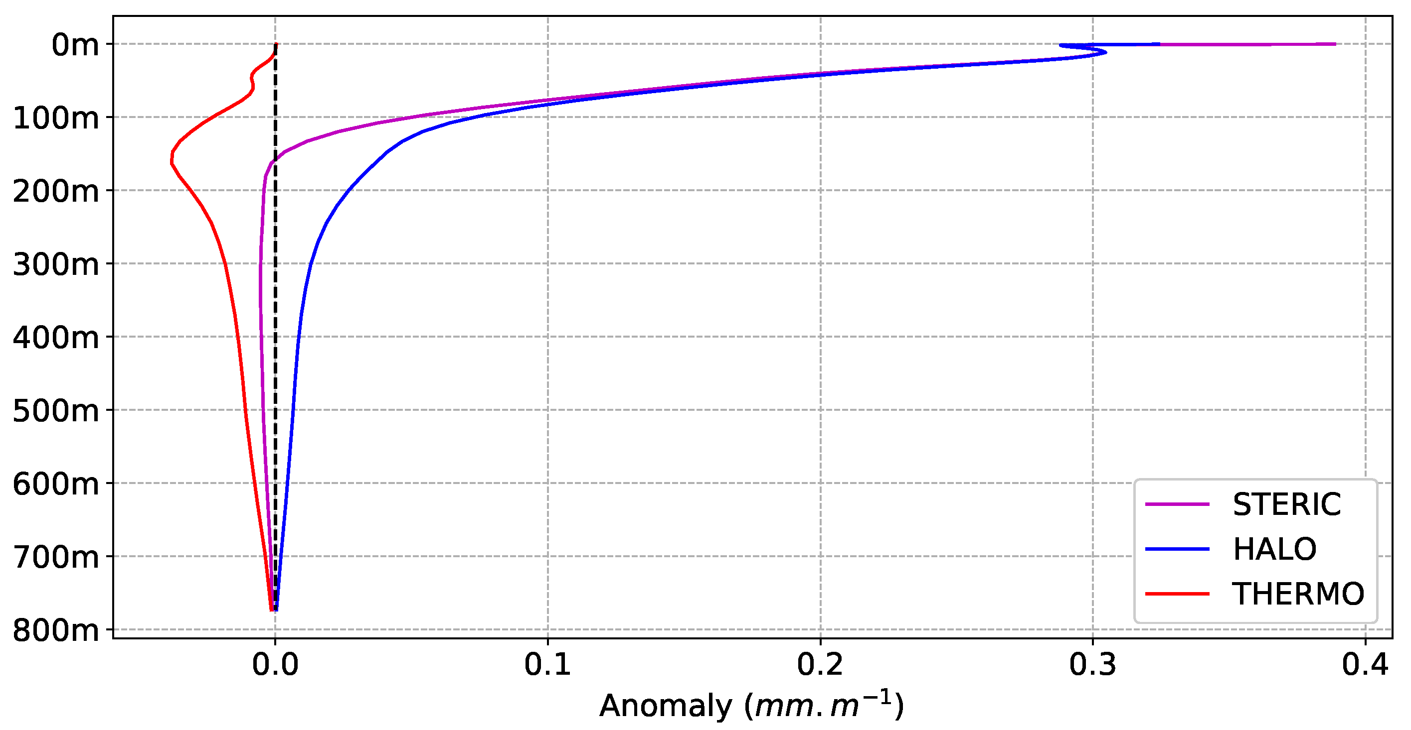
- The MDT anomaly is mostly explained by the halosteric response to freshwater input coming from the Amazon river discharge, located in the upper 250 m of the ocean, while the thermosteric response is weak and tends to counterbalance this effect.
- Regional mass redistributions are observed with a decrease at the river mouth equivalent to 8 cm of mean sea level and increases on continental shelves of the Gulf of Mexico and Caribbean Sea equivalent to 4.5 cm of mean sea level.
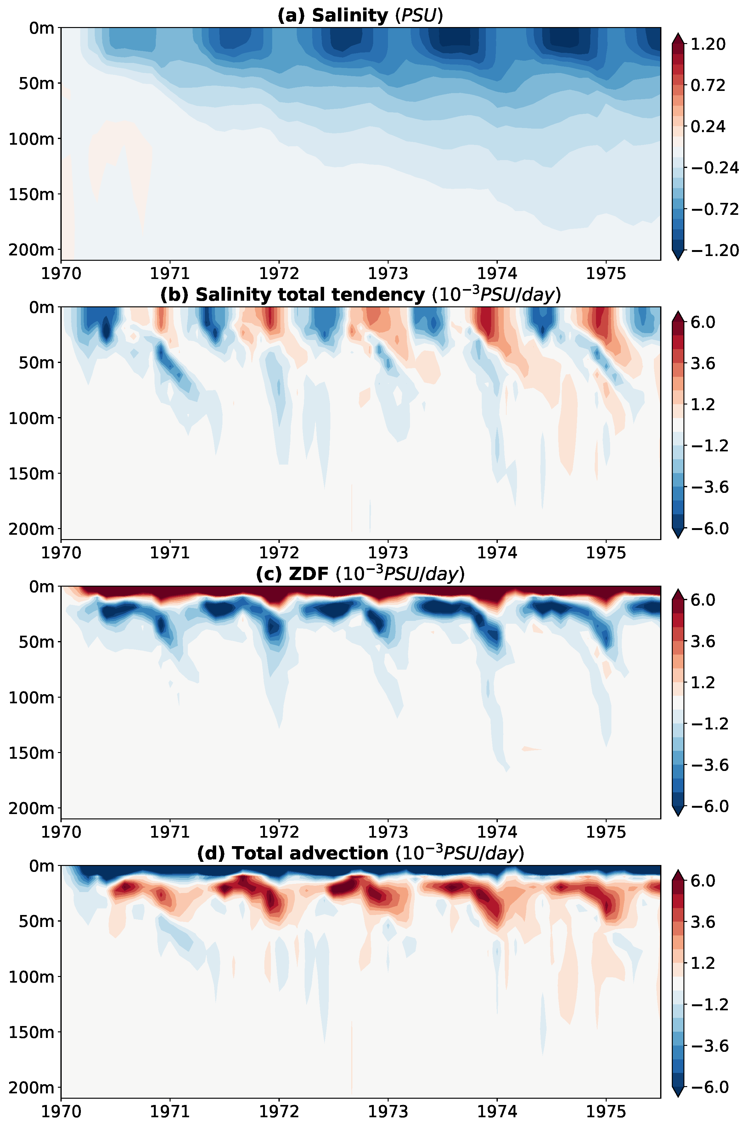
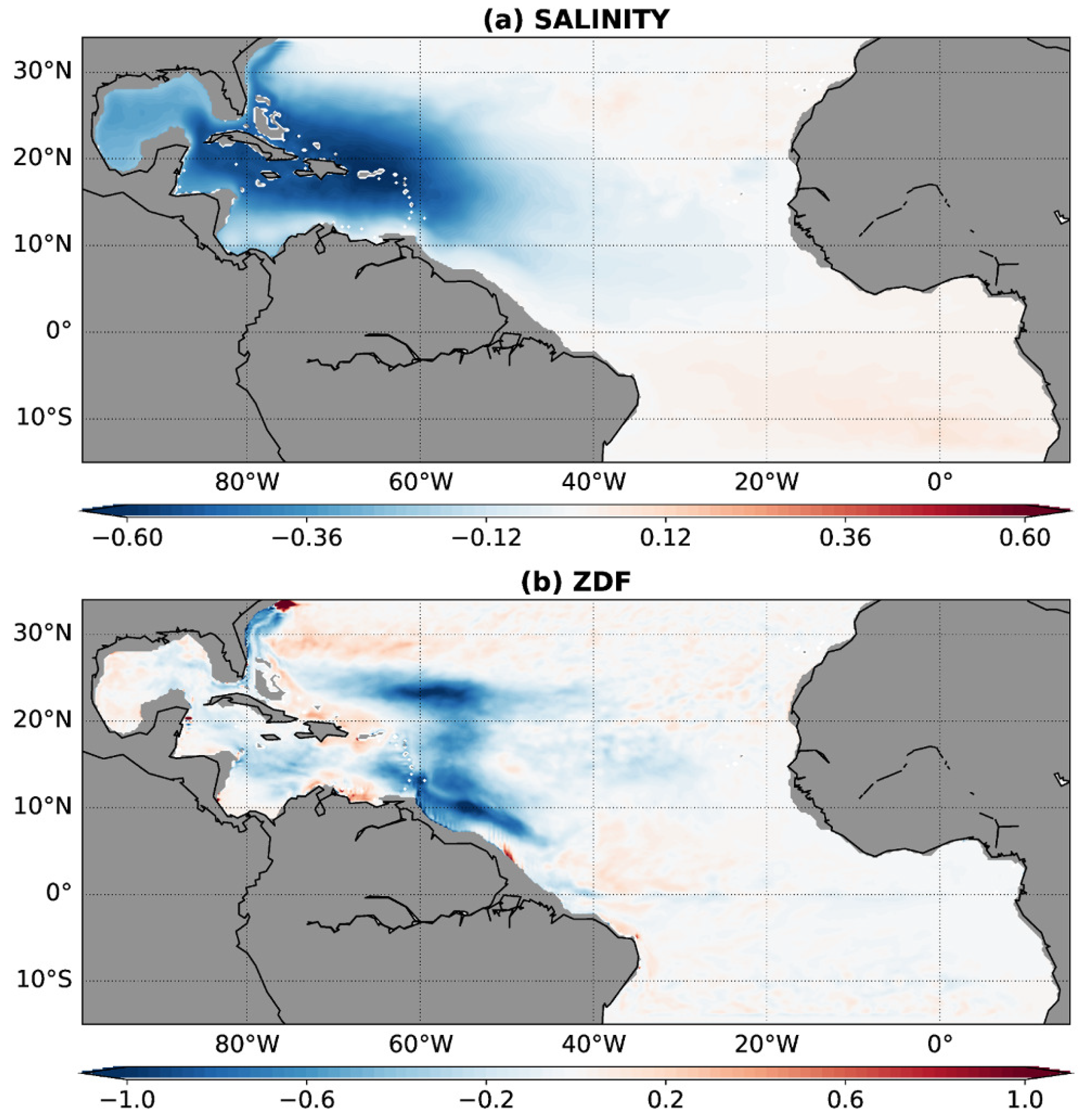
- The Amazon low-salinity plume is mixed with subsurface waters in two remote areas: The first one at (55° W, 10° N); and the second one near (60° W, 23° N). This results in a time-mean salinity anomaly of 0.5 PSU located under 30 m depth over a large region encompassing the Caribbean Archipelago. This subsurface anomaly partly explains the regional sea level anomaly.
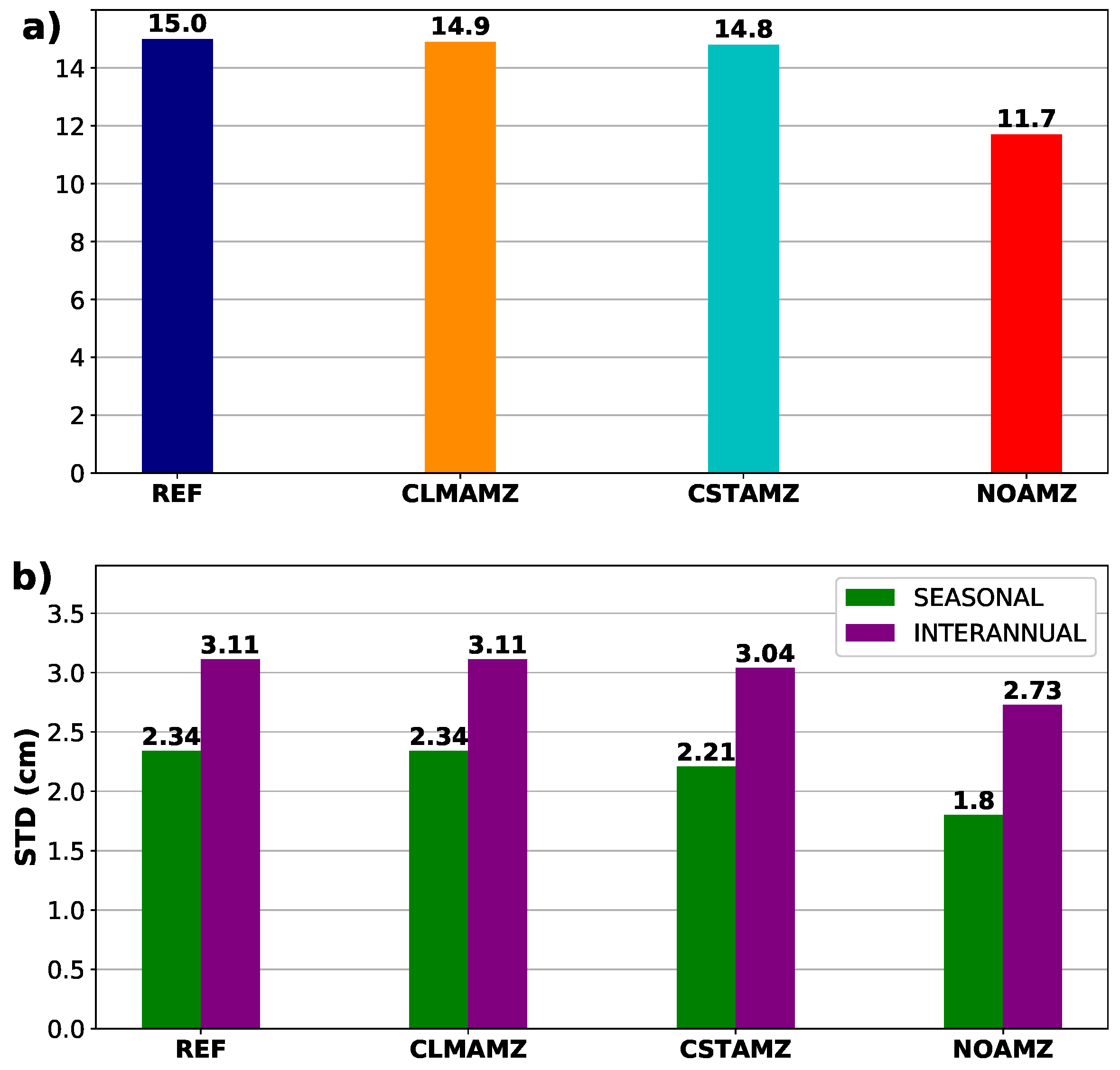
- The Amazon discharge contributes to 23% and 12% of the seasonal and interannual sea level variances in a large area around the Caribbean Archipelago. We showed that the Amazon mean discharge largely explains this sea level variability increase. This suggests that most of the sea level variability associated with the Amazon runoff is the result of the variability of the river plume in response to seasonal and interannual variability of the upper ocean regional circulation. The Amazon seasonal cycle introduces a 6% and 2% additional sea level seasonal and interannual variances, compared to the case with constant Amazon. Finally, interannual variations of the Amazon discharge do not clearly impact sea level variability.
Author Contributions
Funding
Acknowledgments
Conflicts of Interest
References
- WCRP Global Sea Level Budget Group. Global sea-level budget 1993–present. Earth Syst. Sci. Data 2018, 10, 1551–1590. [Google Scholar] [CrossRef]
- Church, J.; Clark, P.; Cazenave, A.; Gregory, J.; Jevrejeva, S.; Levermann, A.; Merrifield, M.; Milne, G.; Nerem, R.; Nunn, P.; et al. Sea Level Change. In Climate Change 2013: The Physical Science Basis. Contribution of Working Group I to the Fifth Assessment Report of the Intergovernmental Panel on Climate Change; Cambridge University Press: Cambridge, UK; New York, NY, USA, 2013; pp. 1138–1191. [Google Scholar]
- Llovel, W.; Meyssignac, B.; Cazenave, A. Steric sea level variations over 2004–2010 as a function of region and depth: Inference on the mass component variability in the North Atlantic Ocean. Geophys. Res. Lett. 2011, 38. [Google Scholar] [CrossRef]
- Llovel, W.; Lee, T. Importance and origin of halosteric contribution to sea level change in the southeast Indian Ocean during 2005–2013. Geophys. Res. Lett. 2015, 42, 1148–1157. [Google Scholar] [CrossRef]
- Lorbacher, K.; Marsland, S.J.; Church, J.A.; Griffies, S.M.; Stammer, D. Rapid barotropic sea level rise from ice sheet melting. J. Geophys. Res. Ocean. 2012, 117. [Google Scholar] [CrossRef]
- Durand, F.; Piecuch, C.G.; Becker, M.; Papa, F.; Raju, S.V.; Khan, J.U.; Ponte, R.M. Impact of Continental Freshwater Runoff on Coastal Sea Level. Surv. Geophys. 2019, 40, 1437–1466. [Google Scholar] [CrossRef]
- Hernandez, O.; Jouanno, J.; Durand, F. Do the Amazon and Orinoco freshwater plumes really matter for hurricane-induced ocean surface cooling? J. Geophys. Res. Ocean. 2016, 121, 2119–2141. [Google Scholar] [CrossRef]
- Ngo-Duc, T.; Laval, K.; Polcher, J.; Lombard, A.; Cazenave, A. Effects of land water storage on global mean sea level over the past half century. Geophys. Res. Lett. 2005, 32. [Google Scholar] [CrossRef]
- Llovel, W.; Becker, M.; Cazenave, A.; Crétaux, J.F.; Ramillien, G. Global land water storage change from GRACE over 2002–2009; Inference on sea level. C. R. Geosci. 2010, 342, 179–188. [Google Scholar] [CrossRef]
- Llovel, W.; Becker, M.; Cazenave, A.; Jevrejeva, S.; Alkama, R.; Decharme, B.; Douville, H.; Ablain, M.; Beckley, B. Terrestrial waters and sea level variations on interannual time scale. Glob. Planet. Chang. 2011, 75, 76–82. [Google Scholar] [CrossRef]
- Chambers, D.P.; Cazenave, A.; Champollion, N.; Dieng, H.; Llovel, W.; Forsberg, R.; von Schuckmann, K.; Wada, Y. Evaluation of the Global Mean Sea Level Budget between 1993 and 2014. Surv. Geophys. 2017, 38, 309–327. [Google Scholar] [CrossRef]
- Meade, R.H.; Emery, K. Sea level as affected by river runoff, eastern United States. Science 1971, 173, 425–428. [Google Scholar] [CrossRef] [PubMed]
- Gough, W.A.; Robinson, C.A. Sea-level Variation in Hudson Bay, Canada, from Tide-Gauge Data. Arctic Antarct. Alp. Res. 2000, 32, 331–335. [Google Scholar] [CrossRef]
- Piecuch, C.G.; Bittermann, K.; Kemp, A.C.; Ponte, R.M.; Little, C.M.; Engelhart, S.E.; Lentz, S.J. River-discharge effects on United States Atlantic and Gulf coast sea-level changes. Proc. Natl. Acad. Sci. USA 2018, 115, 7729–7734. [Google Scholar] [CrossRef] [PubMed]
- Blaha, J.P. Fluctuations of monthly sea level as related to the intensity of the Gulf Stream from Key West to Norfolk. J. Geophys. Res. 1984, 89, 8033. [Google Scholar] [CrossRef]
- Han, W.; Webster, P.J. Forcing Mechanisms of Sea Level Interannual Variability in the Bay of Bengal. J. Phys. Oceanogr. 2002, 32, 216–239. [Google Scholar] [CrossRef]
- Ponte, R.; Carson, M.; Cirano, M.; Domingues, C.; Ezer, T.; Zhang, X. Towards Comprehensive Observing and Modeling Systems for Monitoring and Predicting Regional to Coastal Sea Level. Front. Mar. Sci. 2019. [Google Scholar] [CrossRef]
- Molinier, M.; Guyot, J.L.; Oliveira, E.D.; Guimaraes, V. Les régimes hydrologiques de l’Amazone et de ses affluents. In Hydrologie Tropicale: Géoscience et Outil Pour le Développement; IAHS publication 238; IAHS: Paris, France, 1996; pp. 209–222. [Google Scholar]
- Dai, A.; Trenberth, K.E. Estimates of Freshwater Discharge from Continents: Latitudinal and Seasonal Variations. J. Hydrometeorol. 2002, 3, 660–687. [Google Scholar] [CrossRef]
- Decharme, B.; Delire, C.; Minvielle, M.; Colin, J.; Vergnes, J.P.; Alias, A.; Saint-Martin, D.; Séférian, R.; Sénési, S.; Voldoire, A. Recent Changes in the ISBA-CTRIP Land Surface System for Use in the CNRM-CM6 Climate Model and in Global Off-Line Hydrological Applications. J. Adv. Model. Earth Syst. 2019, 11, 1207–1252. [Google Scholar] [CrossRef]
- Muller-Karger, F.E.; McClain, C.R.; Richardson, P.L. The dispersal of the Amazon’s water. Nature 1988, 333, 56–59. [Google Scholar] [CrossRef]
- Foltz, G.R.; Schmid, C.; Lumpkin, R. Transport of Surface Freshwater from the Equatorial to the Subtropical North Atlantic Ocean. J. Phys. Oceanogr. 2015, 45, 1086–1102. [Google Scholar] [CrossRef]
- Madec, G.; Bourdallé-Badie, R.; Bouttier, P.A.; Bricaud, C.; Bruciaferri, D.; Calvert, D.; Chanut, J.; Clementi, E.; Coward, A.; Delrosso, D.; et al. NEMO Ocean Engine. 2017. Available online: https://www.nemo-ocean.eu/wp-content/uploads/NEMO_book.pdf (accessed on 31 October 2019).
- Hernandez, O.; Jouanno, J.; Echevin, V.; Aumont, O. Modification of sea surface temperature by chlorophyll concentration in the Atlantic upwelling systems. J. Geophys. Res. Ocean. 2017, 122, 5367–5389. [Google Scholar] [CrossRef]
- Penduff, T.; Le Sommer, J.; Barnier, B.; Tréguier, A.M.; Molines, J.M.; Madec, G. Influence of numerical schemes on current-topography interactions in 1/4 global ocean simulations. Ocean. Sci. Discuss. 2007, 4, 491–528. [Google Scholar] [CrossRef]
- Large, W.G.; Yeager, S. The global climatology of an interannually varying air–sea flux data set. Clim. Dyn. 2009, 33, 341–364. [Google Scholar] [CrossRef]
- Dee, D.P.; Uppala, S.; Simmons, A.; Berrisford, P.; Poli, P.; Kobayashi, S.; Andrae, U.; Balmaseda, M.; Balsamo, G.; Bauer, d.P.; et al. The ERA-Interim reanalysis: Configuration and performance of the data assimilation system. Q. J. R. Meteorol. Soc. 2011, 137, 553–597. [Google Scholar] [CrossRef]
- Callede, J.; Guyot, J.L.; Ronchail, J.; Molinier, M.; Oliveira, E. The River Amazon at Óbidos (Brazil): Statistical studies of the discharges and water balance. Hydrol. Sci. J./J. Des Sci. Hydrol. 2002, 321–332. [Google Scholar]
- Boutin, J.; Vergely, J.L.; Marchand, S.; D’Amico, F.; Hasson, A.; Kolodziejczyk, N.; Reul, N.; Reverdin, G.; Vialard, J. New SMOS Sea Surface Salinity with reduced systematic errors and improved variability. Remote. Sens. Environ. 2018, 214, 115–134. [Google Scholar] [CrossRef]
- Legeais, J.F.; Ablain, M.; Zawadzki, L.; Zuo, H.; Johannessen, J.A.; Scharffenberg, M.G.; Fenoglio-Marc, L.; Fernandes, M.J.; Andersen, O.B.; Rudenko, S.; et al. An improved and homogeneous altimeter sea level record from the ESA Climate Change Initiative. Earth Syst. Sci. Data 2018, 10, 281–301. [Google Scholar] [CrossRef]
- Gill, A.E.; Niller, P.P. The theory of the seasonal variability in the ocean. Deep. Sea Res. Oceanogr. Abstr. 1973, 20, 141–177. [Google Scholar] [CrossRef]
- Jordà, G.; Gomis, D. On the interpretation of the steric and mass components of sea level variability: The case of the Mediterranean basin. J. Geophys. Res. Ocean. 2013, 118, 953–963. [Google Scholar] [CrossRef]
- Gregory, J.M.; Griffies, S.M.; Hughes, C.W.; Lowe, J.A.; Church, J.A.; Fukimori, I.; Gomez, N.; Kopp, R.E.; Landerer, F.; Cozannet, G.L.; et al. Concepts and Terminology for Sea Level: Mean, Variability and Change, Both Local and Global. Surv. Geophys. 2019, 40, 1251–1289. [Google Scholar] [CrossRef]
- Griffies, S.M.; Yin, J.; Durack, P.J.; Goddard, P.; Bates, S.C.; Behrens, E.; Bentsen, M.; Bi, D.; Biastoch, A.; Böning, C.W.; et al. An assessment of global and regional sea level for years 1993–2007 in a suite of interannual CORE-II simulations. Ocean. Model. 2014, 78, 35–89. [Google Scholar] [CrossRef]
- Landerer, F.W.; Jungclaus, J.H.; Marotzke, J. Regional Dynamic and Steric Sea Level Change in Response to the IPCC-A1B Scenario. J. Phys. Oceanogr. 2007, 37, 296–312. [Google Scholar] [CrossRef]
- Espinoza Villar, J.C.; Guyot, J.L.; Ronchail, J.; Cochonneau, G.; Filizola, N.; Fraizy, P.; Labat, D.; de Oliveira, E.; Ordoñez, J.J.; Vauchel, P. Contrasting regional discharge evolutions in the Amazon basin (1974–2004). J. Hydrol. 2009, 375, 297–311. [Google Scholar] [CrossRef]
- Marengo, J.A.; Espinoza, J.C. Extreme seasonal droughts and floods in Amazonia: Causes, trends and impacts. Int. J. Climatol. 2016, 36, 1033–1050. [Google Scholar] [CrossRef]
- Latrubesse, E.; Arima, E.; Dunne, T.; Park, E.; Baker, V.R.; d’Horta, F.; Wight, C.; Wittmann, F.; Zuanon, J.; Baker, P.; et al. Damming the rivers of the Amazon basin. Nature 2017, 546, 363–369. [Google Scholar] [CrossRef] [PubMed]
- Castello, L.; Macedo, M.N. Large-scale degradation of Amazonian freshwater ecosystems. Glob. Chang. Biol 2016, 22, 990–1007. [Google Scholar] [CrossRef] [PubMed]
- Poff, N.L.; Allan, J.D.; Bain, M.B.; Karr, J.R.; Prestegaard, K.L.; Richter, B.D.; Sparks, R.E.; Stromberg, J.C. The Natural Flow Regime. BioScience 1997, 47, 769–784. [Google Scholar] [CrossRef]


© 2019 by the authors. Licensee MDPI, Basel, Switzerland. This article is an open access article distributed under the terms and conditions of the Creative Commons Attribution (CC BY) license (http://creativecommons.org/licenses/by/4.0/).
Share and Cite
Giffard, P.; Llovel, W.; Jouanno, J.; Morvan, G.; Decharme, B. Contribution of the Amazon River Discharge to Regional Sea Level in the Tropical Atlantic Ocean. Water 2019, 11, 2348. https://doi.org/10.3390/w11112348
Giffard P, Llovel W, Jouanno J, Morvan G, Decharme B. Contribution of the Amazon River Discharge to Regional Sea Level in the Tropical Atlantic Ocean. Water. 2019; 11(11):2348. https://doi.org/10.3390/w11112348
Chicago/Turabian StyleGiffard, Pierrick, William Llovel, Julien Jouanno, Guillaume Morvan, and Bertrand Decharme. 2019. "Contribution of the Amazon River Discharge to Regional Sea Level in the Tropical Atlantic Ocean" Water 11, no. 11: 2348. https://doi.org/10.3390/w11112348
APA StyleGiffard, P., Llovel, W., Jouanno, J., Morvan, G., & Decharme, B. (2019). Contribution of the Amazon River Discharge to Regional Sea Level in the Tropical Atlantic Ocean. Water, 11(11), 2348. https://doi.org/10.3390/w11112348