Suitability Mapping for Managed Aquifer Recharge: Development of Web-Tools

 , ,
, , 
Abstract
:1. Introduction
2. Implications from Reviewing GIS-MCDA Studies
3. Materials and Methods
4. Results
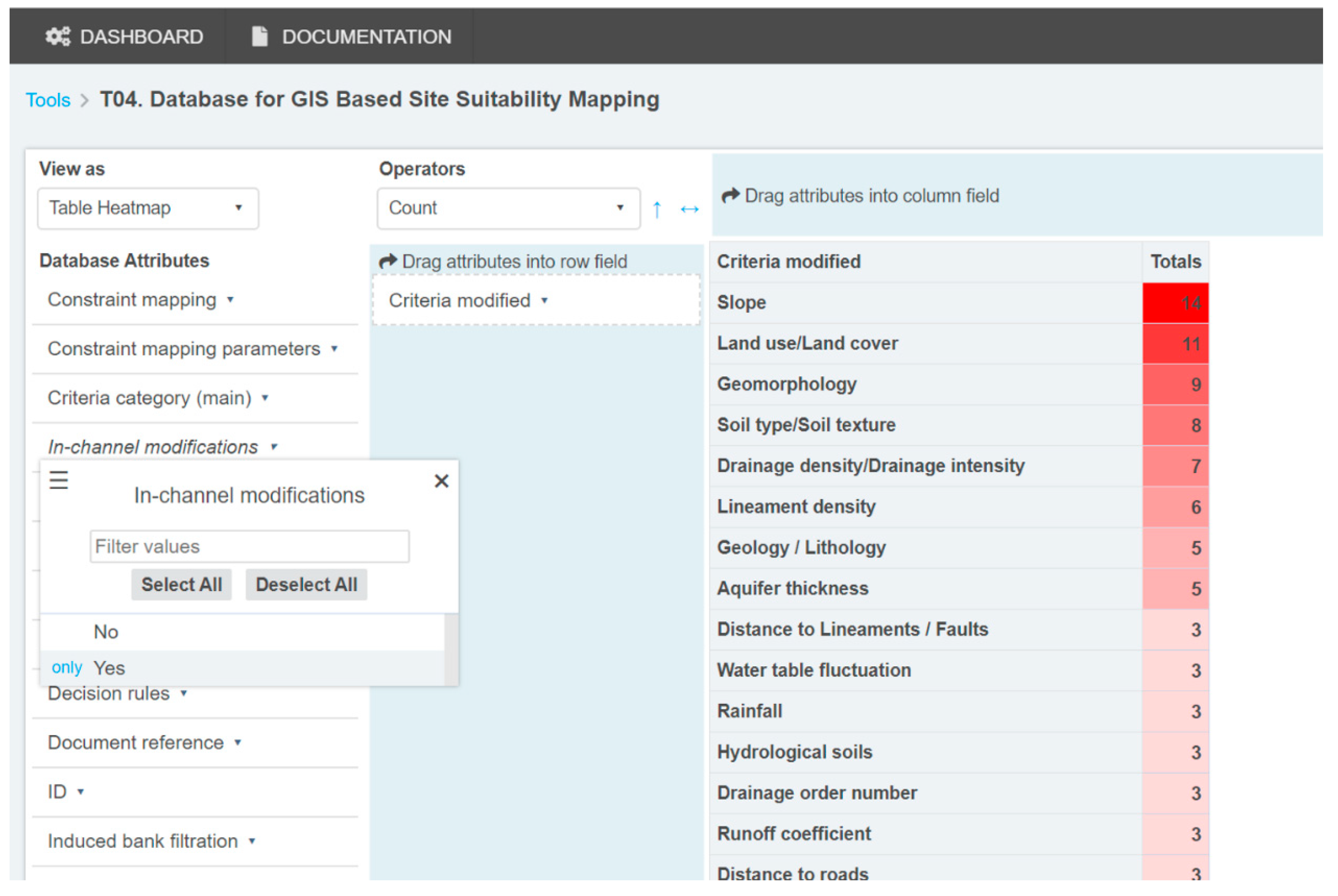
4.1. Database Query Tool
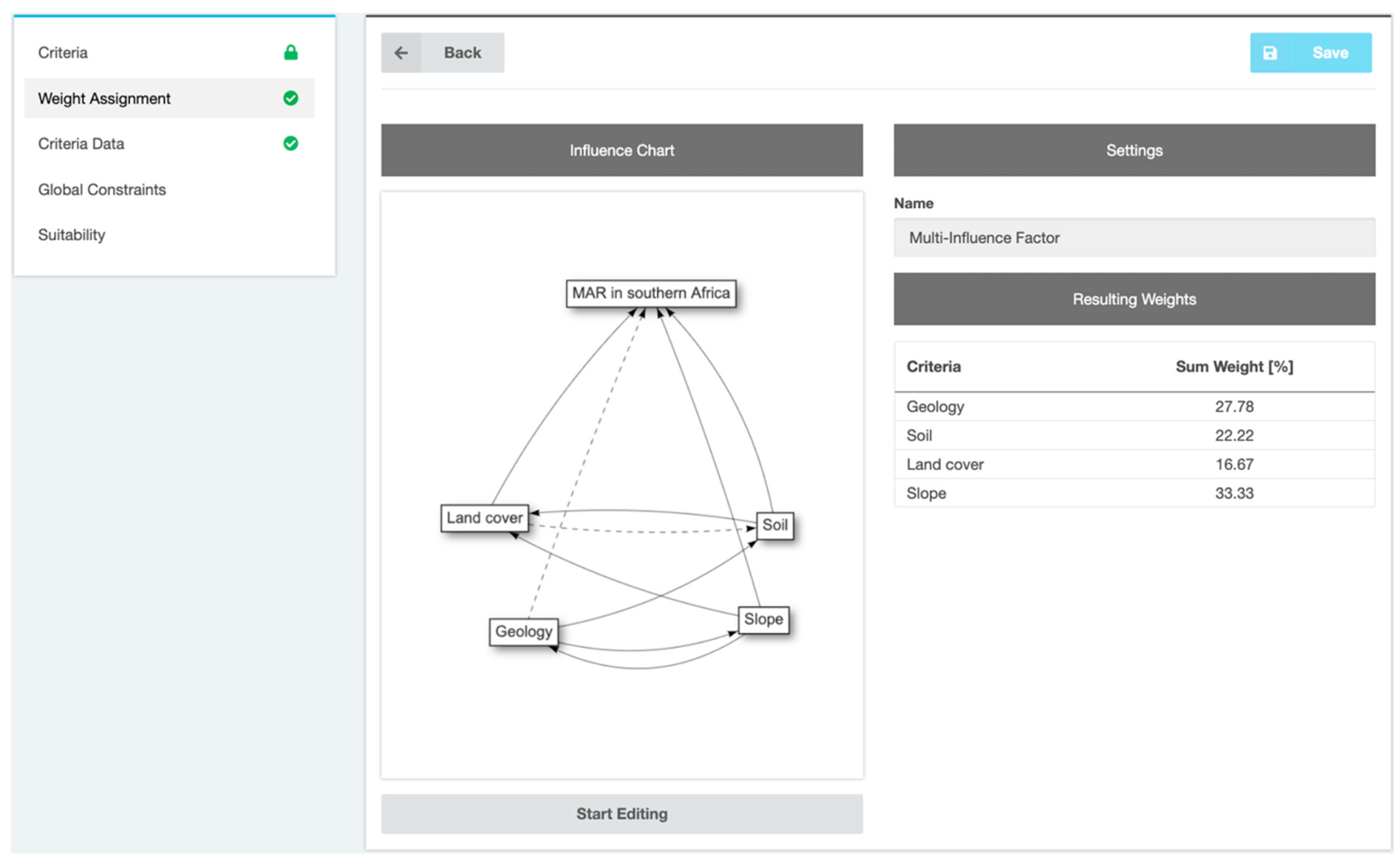
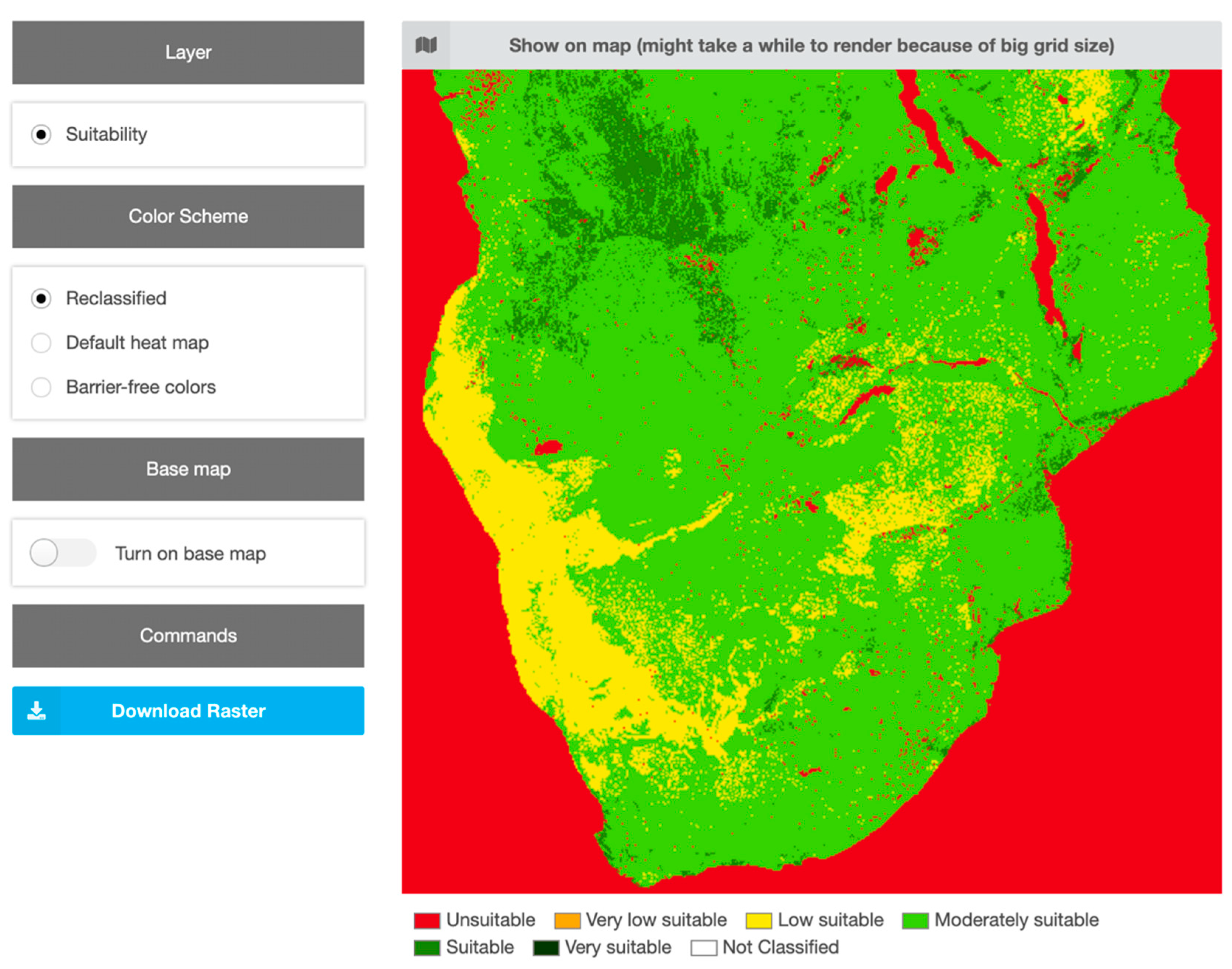
4.2. Web GIS for Suitability Mapping
5. Discussion
6. Conclusions
Author Contributions
Funding
Acknowledgments
Conflicts of Interest
References
- Stefan, C.; Ansems, N. Web-based global inventory of managed aquifer recharge applications. Sustain. Water Resour. Manag. 2018, 4, 153–162. [Google Scholar] [CrossRef]
- Dillon, P.; Stuyfzand, P.; Grischek, T.; Lluria, M.; Pyne, R.D.G.; Jain, R.C.; Bear, J.; Schwarz, J.; Wang, W.; Fernandez, E.; et al. Sixty years of global progress in managed aquifer recharge. Hydrogeol. J. 2019, 27, 1–30. [Google Scholar] [CrossRef]
- Government of India. Manual on Artificial Recharge of Ground Water; Government of India, Ministry of Water Resources, Central Ground Water Board: Faridabad, India, 2007.
- NRMMC-EPHC-AHMC. Australian Guidelines for Water Recycling. Managed Aquifer Recharge; National Water Quality Management Strategy: Canberra, Australia, 2009. [Google Scholar]
- Ministro de Obras Públicas. Diagnóstico De Metodología Para La Presentación Y Análisis De Proyectos De Recarga Artificial De Acuíferos. 2014. Available online: http://documentos.dga.cl/Resumen_Ejecutivo%20RA_v0.pdf (accessed on 27 October 2019).
- Secretaría del Medio Ambiente y Recursos Naturale. De medio ambiente y recursos naturales. In Norma Oficial Mexicana NOM-015-CONAGUA-2007, Infiltración Artificial De Agua A Los Acuíferos.-Características Y Especificaciones De Las Obras Y Del Agua. 2009. Available online: http://www.conagua.gob.mx/CONAGUA07/Contenido/Documentos/NOM-015-CONAGUA2007.pdf (accessed on 27 October 2019).
- Dillon, P. Future management of aquifer recharge. Hydrogeol. J. 2005, 13, 313–316. [Google Scholar] [CrossRef]
- Rahman, M.A.; Rusteberg, B.; Gogu, R.C.; Lobo Ferreira, J.P.; Sauter, M. A new spatial multi-criteria decision support tool for site selection for implementation of managed aquifer recharge. J. Environ. Manag. 2012, 99, 61–75. [Google Scholar] [CrossRef]
- Shankar, M.N.R.; Mohan, G. A GIS based hydrogeomorphic approach for identification of site-specific artificial-recharge techniques in the Deccan Volcanic Province. J. Earth Syst. Sci. 2005, 114, 505–514. [Google Scholar] [CrossRef]
- Russo, T.A.; Fisher, A.T.; Lockwood, B.S. Assessment of Managed Aquifer Recharge Site Suitability Using a GIS and Modeling. Groundwater 2015, 53, 389–400. [Google Scholar] [CrossRef]
- Sallwey, J.; Bonilla Valverde, J.P.; Vásquez López, F.; Junghanns, R.; Stefan, C. Suitability maps for managed aquifer recharge: A review of multi-criteria decision analysis studies. Environ. Rev. 2018, 27, 138–150. [Google Scholar] [CrossRef]
- De Winnaar, G.; Jewitt, G.P.W.; Horan, M. A GIS-based approach for identifying potential runoff harvesting sites in the Thukela River basin, South Africa. Phys. Chem. Earth Parts ABC 2007, 32, 1058–1067. [Google Scholar] [CrossRef]
- Selvam, S.; Dar, F.A.; Magesh, N.S.; Singaraja, C.; Venkatramanan, S.; Chung, S.Y. Application of remote sensing and GIS for delineating groundwater recharge potential zones of Kovilpatti Municipality, Tamil Nadu using IF technique. Earth Sci. Inform. 2016, 9, 137–150. [Google Scholar] [CrossRef]
- Saidi, S.; Hosni, S.; Mannai, H.; Jelassi, F.; Bouri, S.; Anselme, B. GIS-based multi-criteria analysis and vulnerability method for the potential groundwater recharge delineation, case study of Manouba phreatic aquifer, NE Tunisia. Environ. Earth Sci. 2017, 76, 511. [Google Scholar] [CrossRef]
- Raviraj, A.; Kuruppath, N.; Kannan, B. Identification of potential groundwater recharge zones using remote sensing and geographical information system in Amravathi Basin. In Modelling Impact of Climatic Variability on Groundwater Dynamics; Water Technology Centre, Tamil Nadu Agricultural University: Coimbatore, India, 2016; pp. 109–133. ISBN 978-93-83799-28-2. [Google Scholar]
- Malczewski, J. GIS and Multicriteria Decision Analysis; John Wiley & Sons: New York, NY, USA, 1999. [Google Scholar]
- Malczewski, J.; Rinner, C. Multicriteria Decision Analysis in Geographic Information Science; Springer: Berlin, Germany, 2015. [Google Scholar]
- Shaban, A.; Khawlie, M.; Abdallah, C. Use of remote sensing and GIS to determine recharge potential zones: The case of Occidental Lebanon. Hydrogeol. J. 2005, 14, 433–443. [Google Scholar] [CrossRef]
- Magesh, N.S.; Chandrasekar, N.; Soundranayagam, J.P. Delineation of groundwater potential zones in Theni district, Tamil Nadu, using remote sensing, GIS and MIF techniques. Geosci. Front. 2012, 3, 189–196. [Google Scholar] [CrossRef] [Green Version]
- Saaty, T.L. The Analytic Hierarchy Process; McGraw-Hill: New York, NY, USA, 1980. [Google Scholar]
- Marinoni, O. Implementation of the analytical hierarchy process with VBA in ArcGIS. Comput. Geosci. 2004, 30, 637–646. [Google Scholar] [CrossRef]
- Anane, M.; Kallali, H.; Jellali, S.; Ouessar, M. Ranking suitable sites for Soil Aquifer Treatment in Jerba Island (Tunisia) using remote sensing, GIS and AHP-multicriteria decision analysis. Int. J. Water 2008, 4, 121–135. [Google Scholar] [CrossRef]
- Schlick, R. Visualizing the MAR Potential for Africa through GIS-MCDA and Web-Based Tool Design; Technische Universität Dresden: Dresden, Germany, 2019. [Google Scholar]
- Parker, J.A.; Kenyon, R.V.; Troxel, D.E. Comparison of Interpolating Methods for Image Resampling. IEEE Trans. Med. Imaging 1983, 2, 31–39. [Google Scholar] [CrossRef]
- Cinelli, M.; Coles, S.R.; Kirwan, K. Analysis of the potentials of multi criteria decision analysis methods to conduct sustainability assessment. Ecol. Indic. 2014, 46, 138–148. [Google Scholar] [CrossRef] [Green Version]
- Gounaridis, D.; Zaimes, G.N. GIS-based multicriteria decision analysis applied for environmental issues; the Greek experience. Int. J. Appl. Environ. Sci. 2012, 7, 307–321. [Google Scholar]
- Esmail, B.A.; Geneletti, D. Multi-criteria decision analysis for nature conservation: A review of 20 years of applications. Methods Ecol. Evol. 2018, 9, 42–53. [Google Scholar] [CrossRef]
- Brown, C.J.; Weiss, R.; Verrastro, R.; Schubert, S. Development of an Aquifer, Storage and Recovery (ASR) Site Selection Suitability Index in Support of the Comprehensive Everglades Restoration Project. J. Environ. Hydrol. 2005, 13, 1–13. [Google Scholar]
- Jamali, I.A.; Mörtberg, U.; Olofsson, B.; Shafique, M. A Spatial Multi-Criteria Analysis Approach for Locating Suitable Sites for Construction of Subsurface Dams in Northern Pakistan. Water Resour. Manag. 2014, 28, 5157–5174. [Google Scholar] [CrossRef]
- Satapathy, I.; Syed, T.H. Characterization of groundwater potential and artificial recharge sites in Bokaro District, Jharkhand (India), using remote sensing and GIS-based techniques. Environ. Earth Sci. 2015, 74, 4215–4232. [Google Scholar] [CrossRef]


© 2019 by the authors. Licensee MDPI, Basel, Switzerland. This article is an open access article distributed under the terms and conditions of the Creative Commons Attribution (CC BY) license (http://creativecommons.org/licenses/by/4.0/).
Share and Cite
Sallwey, J.; Schlick, R.; Bonilla Valverde, J.P.; Junghanns, R.; Vásquez López, F.; Stefan, C. Suitability Mapping for Managed Aquifer Recharge: Development of Web-Tools. Water 2019, 11, 2254. https://doi.org/10.3390/w11112254
Sallwey J, Schlick R, Bonilla Valverde JP, Junghanns R, Vásquez López F, Stefan C. Suitability Mapping for Managed Aquifer Recharge: Development of Web-Tools. Water. 2019; 11(11):2254. https://doi.org/10.3390/w11112254
Chicago/Turabian StyleSallwey, Jana, Robert Schlick, José Pablo Bonilla Valverde, Ralf Junghanns, Felipe Vásquez López, and Catalin Stefan. 2019. "Suitability Mapping for Managed Aquifer Recharge: Development of Web-Tools" Water 11, no. 11: 2254. https://doi.org/10.3390/w11112254
APA StyleSallwey, J., Schlick, R., Bonilla Valverde, J. P., Junghanns, R., Vásquez López, F., & Stefan, C. (2019). Suitability Mapping for Managed Aquifer Recharge: Development of Web-Tools. Water, 11(11), 2254. https://doi.org/10.3390/w11112254