Benchmarking Landsat-8 Collection 2 Level-2 Land Surface Temperature Accuracy Using SURFRAD Stations: Effects of Seasonality and Atmospheric Water Vapor

 ,
,  and
and
Abstract
1. Introduction
2. Materials and Methods
2.1. Landsat-8 Collection 2 Level-2 Data
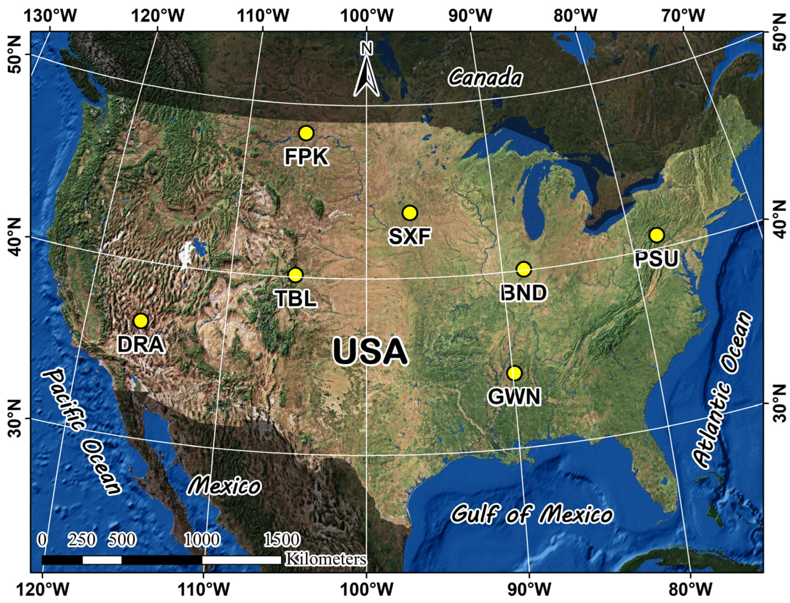
2.2. SURFRAD Ground Stations
2.3. Processing and Analysis Methodology
2.3.1. Landsat-8 Satellite Data Extraction
2.3.2. Land Surface Temperature Calculation from SURFRAD Stations
2.3.3. Atmospheric Water Vapor Data from MODIS
2.3.4. Statistical Analysis
- Primary Accuracy Metrics:
- Percentile-Based Metrics:
- Correlation Analysis:
3. Results
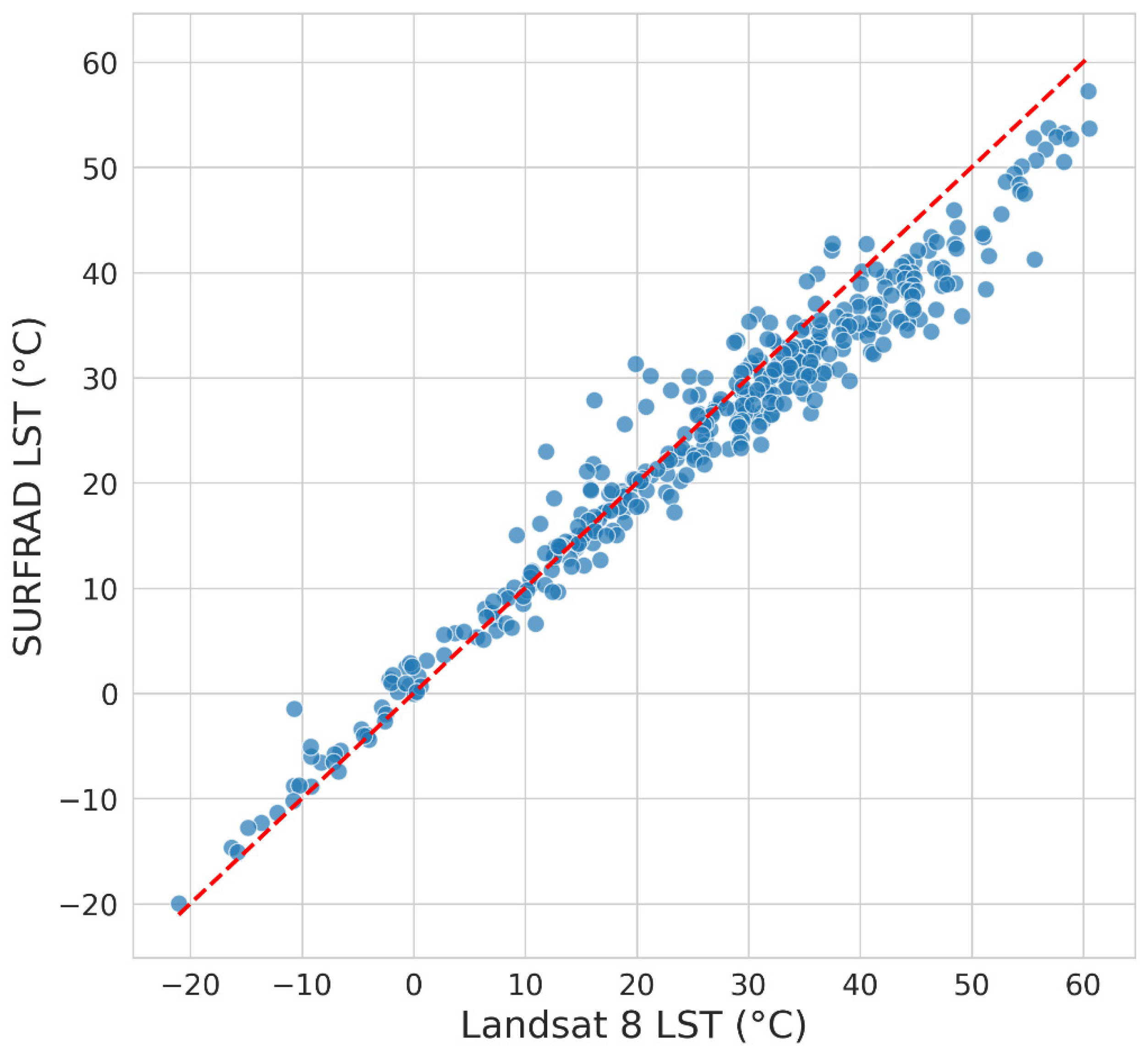
3.1. Overall Performance Assessment of Landsat-8 C2L2 Surface Temperature Product
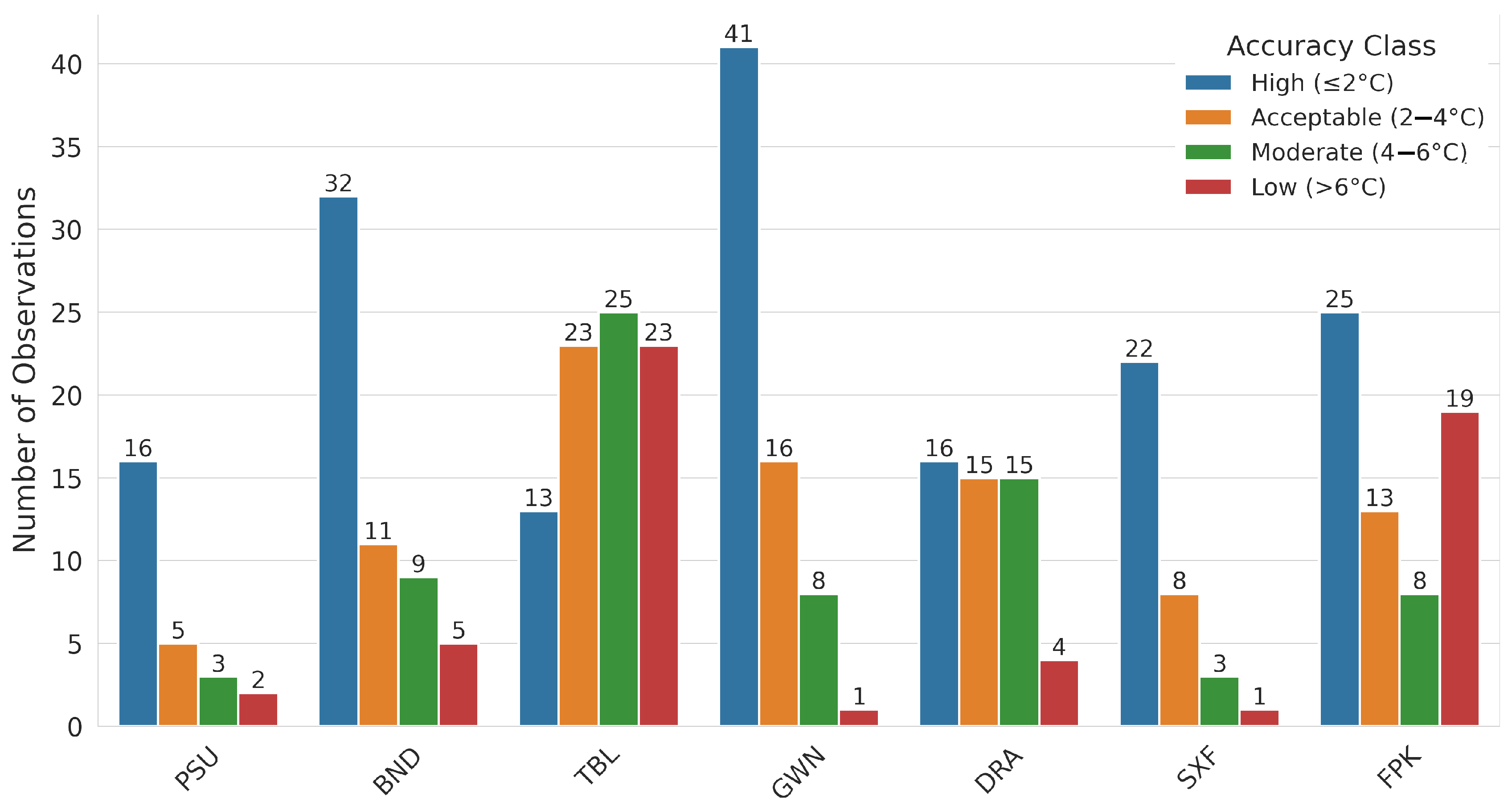
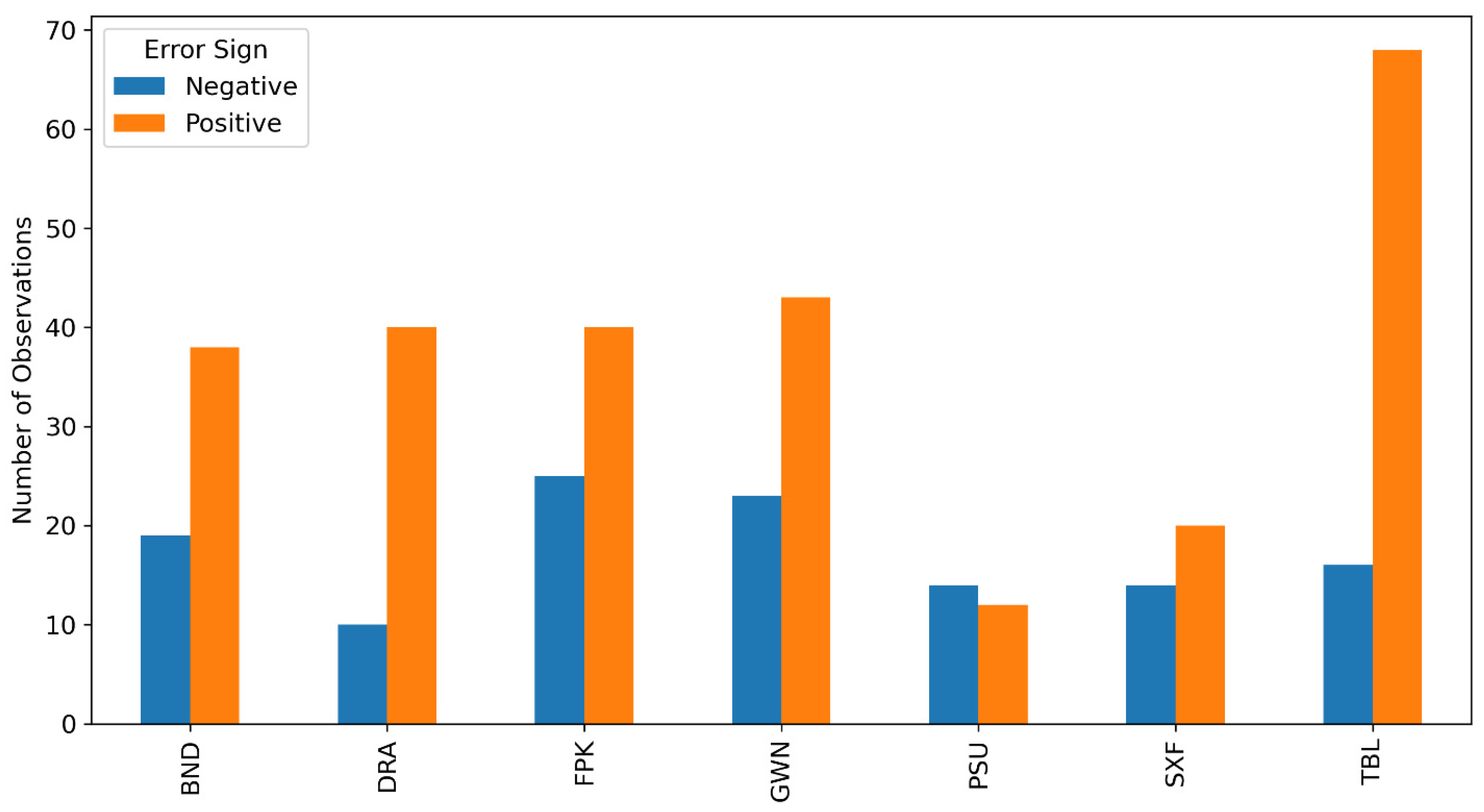
3.2. Accuracy Assessment by Error Categories and Distribution Across Stations
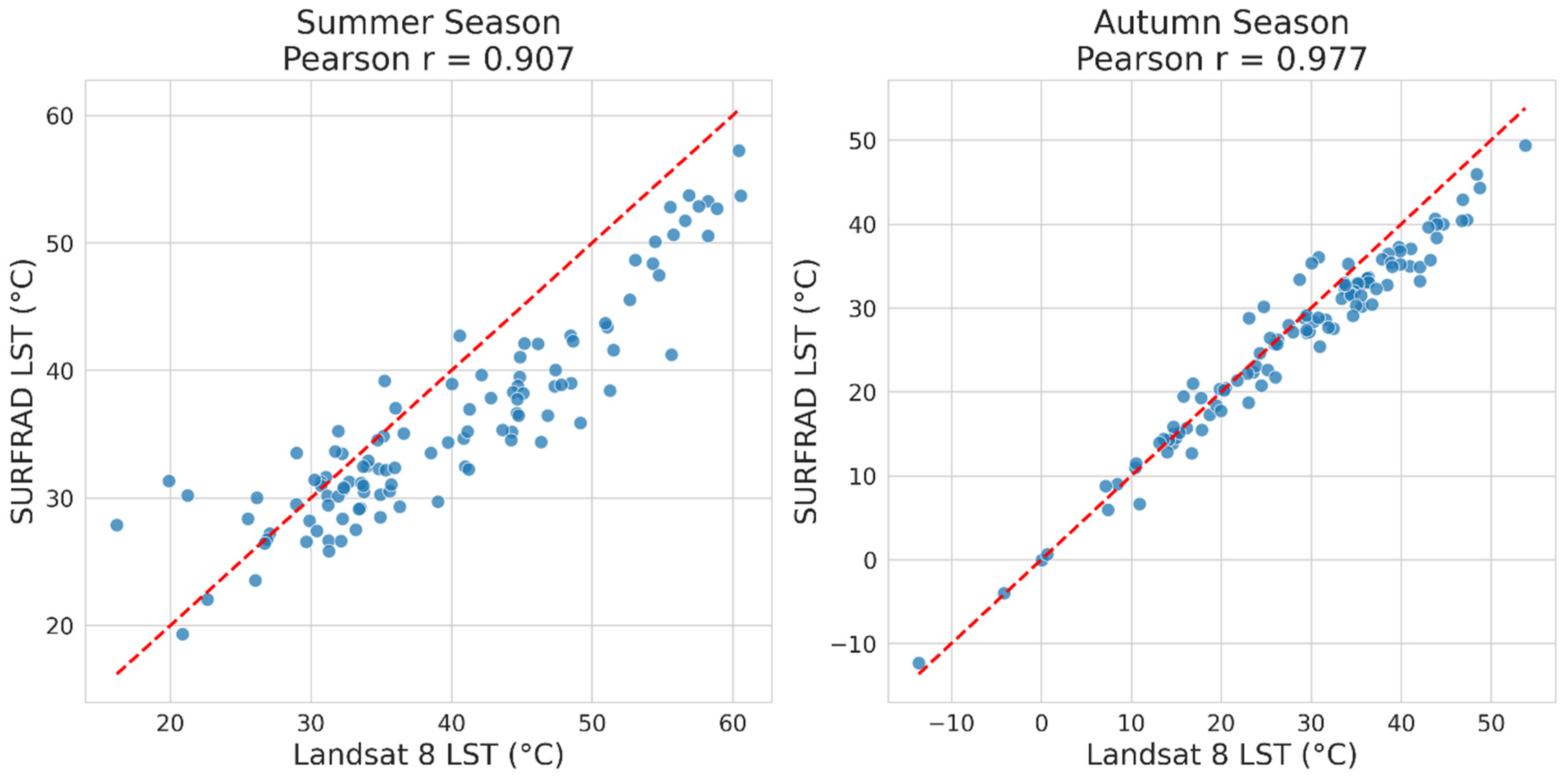
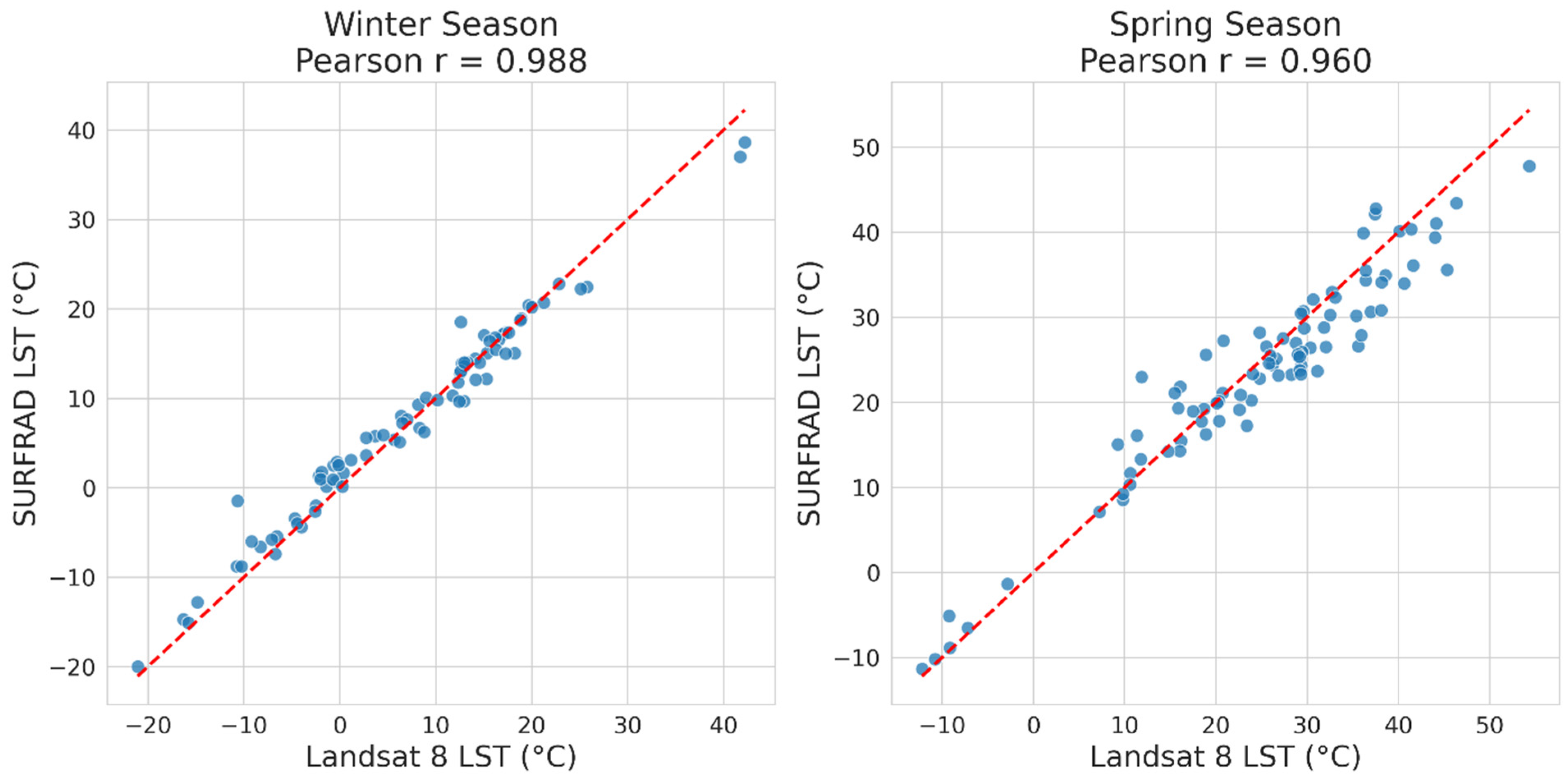
3.3. Performance Assessment by Seasonal Periods
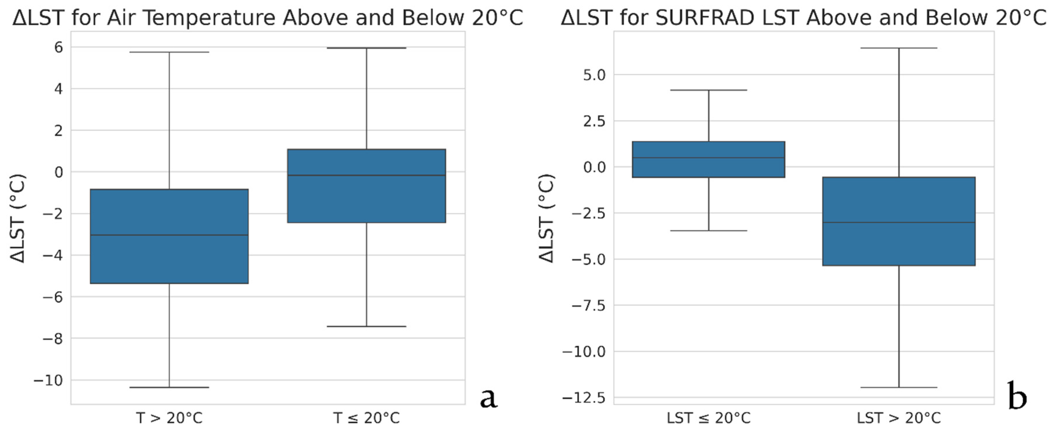
3.4. Performance Assessment by Temperature Ranges
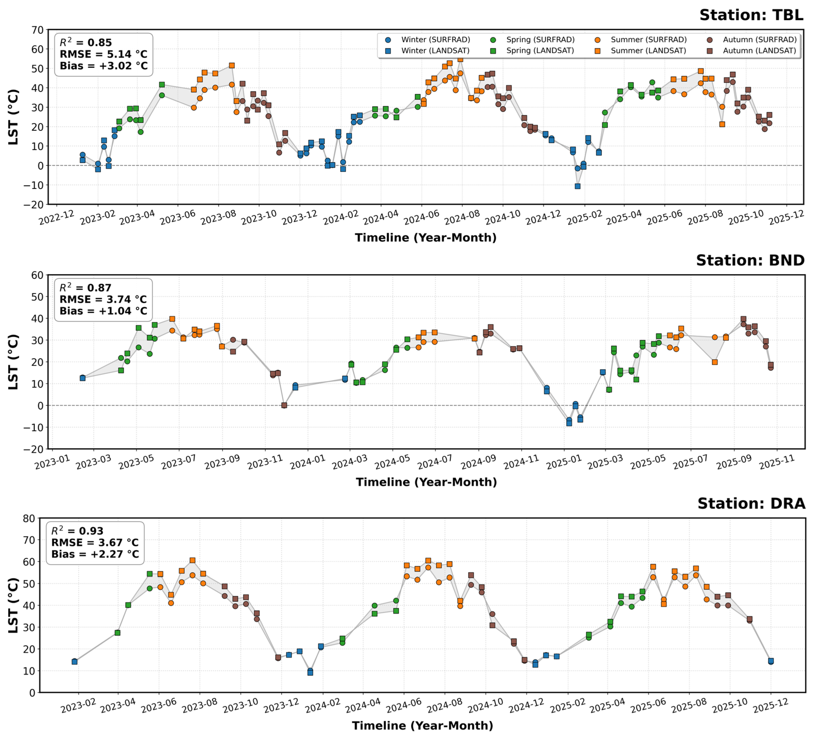
3.5. Analysis of Difference Trends Between Space-Based and Ground Measurements
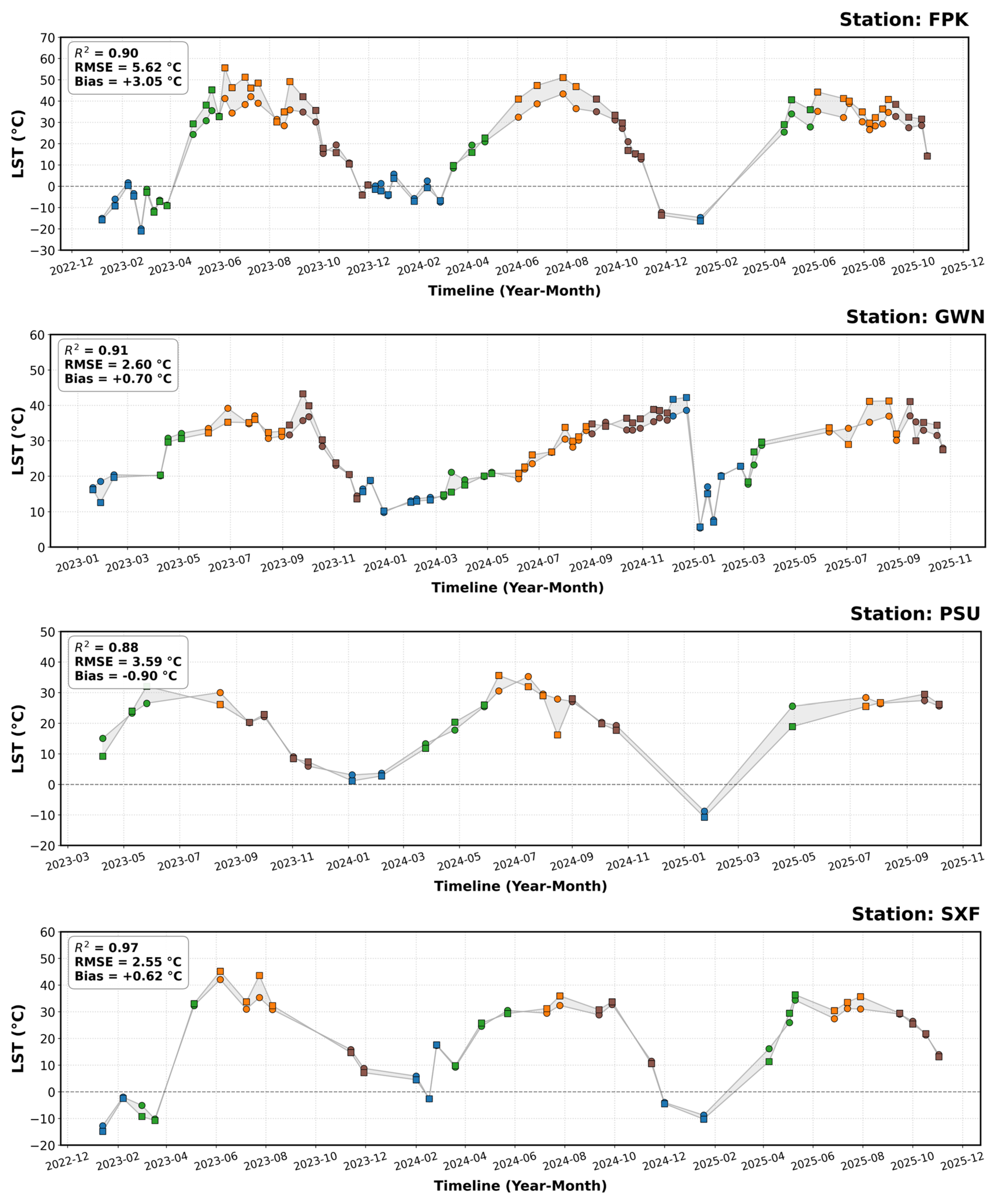
3.6. Performance Evaluation by Ground Stations
3.7. Performance Evaluation by Land Surface Temperature Ranges
3.8. Relationship Between LST Errors and Atmospheric Water Vapor
4. Discussion
4.1. Seasonal Performance and Atmospheric Water Vapor
4.2. Temperature-Dependent Performance and Systematic Bias
4.3. Station-Level Performance and Spatial Variability
5. Conclusions
Author Contributions
Funding
Institutional Review Board Statement
Informed Consent Statement
Data Availability Statement
Acknowledgments
Conflicts of Interest
References
- Gaonkar, V.P.; Nadaf, F.M.; Kapale, V. Decoding urban heat: A decadal analysis (1991-2021) of land surface temperature and thermal comfort dynamics in Coastal Taluka of Bardez, Goa, India. Disaster Adv. 2024, 18, 1–17. [Google Scholar] [CrossRef]
- Panigrahi, M.; Sharma, A. Urban growth dynamics and its influence on land surface temperature in Bhubaneswar metropolitan city: A 1990–2021 analysis. Discov. Appl. Sci. 2025, 7, 118. [Google Scholar] [CrossRef]
- Anderson, M.C.; Hain, C.; Wardlow, B.; Pimstein, A.; Mecikalski, J.R.; Kustas, W.P. Evaluation of drought indices based on thermal remote sensing of evapotranspiration over the Continental United States. J. Clim. 2011, 24, 2025–2044. [Google Scholar] [CrossRef]
- Chen, J.; Shi, X.; Shi, Y.; Delina, L.L. Assessing heat vulnerability risk of Jinan and Guangzhou’s older populations based on multisource remote sensing data. Build. Environ. 2025, 271, 112622. [Google Scholar] [CrossRef]
- Clinton, N.; Gong, P. MODIS detected surface urban heat islands and sinks: Global locations and controls. Remote Sens. Environ. 2013, 134, 294–304. [Google Scholar] [CrossRef]
- Colombi, G.; Vineis, P. Editorial: The relationship between health and environment under the lens of climate change: Insights for policy makers. Front. Public Health 2025, 13, 1548553. [Google Scholar] [CrossRef] [PubMed]
- Djebbour, M.; Sbai, A. Urban island modeling for semi-arid cities: The case of the city of Oujda. E3S Web Conf. 2025, 607, 04005. [Google Scholar] [CrossRef]
- Li, Y.; Zhao, H.; Li, K.; Zeng, J.; Lan, Q.; Han, Q.; Wu, Y.; Qian, Y. A nonlinear hybrid algorithm for retrieving land surface temperatures from chinese atmospheric environment monitoring satellite thermal infrared data. IEEE J. Sel. Top. Appl. Earth Obs. Remote Sens. 2025, 18, 4050–4059. [Google Scholar] [CrossRef]
- Li, Z.-L.; Tang, B.-H.; Wu, H.; Ren, H.; Yan, G.; Wan, Z.; Trigo, I.F.; Sobrino, J.A. Satellite-derived land surface temperature: Current status and perspectives. Remote Sens. Environ. 2013, 131, 14–37. [Google Scholar] [CrossRef]
- Weng, Q. Thermal infrared remote sensing for urban climate and environmental studies: Methods, applications, and trends. ISPRS J. Photogramm. Remote Sens. 2009, 64, 335–344. [Google Scholar] [CrossRef]
- Sekertekin, A.; Bonafoni, S. Land surface temperature retrieval from Landsat 5, 7, and 8 over rural areas: Assessment of different retrieval algorithms and emissivity models and toolbox implementation. Remote Sens. 2020, 12, 294. [Google Scholar] [CrossRef]
- U.S. Geological Survey. Landsat 8 (L8) Data Users Handbook (LSDS-1574, Version 5.0); U.S. Department of the Interior: Reston VA, USA, 2019. Available online: https://d9-wret.s3.us-west-2.amazonaws.com/assets/palladium/production/s3fs-public/atoms/files/LSDS-1574_L8_Data_Users_Handbook-v5.0.pdf (accessed on 24 August 2025).
- Meng, X.; Li, H.; Du, Y.; Liu, Q.; Zhu, J.; Sun, L. Retrieving land surface temperature from Landsat 8 TIRS data using RTTOV and ASTER GED. In Proceedings of the 2016 IEEE International Geoscience and Remote Sensing Symposium (IGARSS), Beijing, China, 10–15 July 2016; IEEE: Piscataway, NJ, USA, 2016; pp. 4302–4305. [Google Scholar] [CrossRef]
- Sayler, K. Landsat 8-9 Collection 2 Level 2 Science Product Guide; U.S. Geological Survey: Reston, VA, USA, 2024. Available online: https://www.usgs.gov/media/files/landsat-8-9-collection-2-level-2-science-product-guide (accessed on 22 June 2025).
- Gök, D.T.; Scherler, D.; Wulf, H. Land surface temperature trends derived from Landsat imagery in the Swiss Alps. Cryosphere 2024, 18, 5259–5276. [Google Scholar] [CrossRef]
- Sajib, M.Q.U.; Wang, T. Estimation of land surface temperature in an agricultural region of Bangladesh from Landsat 8: Intercomparison of four algorithms. Sensors 2020, 20, 1778. [Google Scholar] [CrossRef] [PubMed]
- Yu, X.; Guo, X.; Wu, Z. Land surface temperature retrieval from Landsat 8 TIRS—Comparison between radiative transfer equation-based method, split window algorithm and single channel method. Remote Sens. 2014, 6, 9829–9852. [Google Scholar] [CrossRef]
- Jiménez-Muñoz, J.C.; Cristobal, J.; Sobrino, J.A.; Soria, G.; Ninyerola, M.; Pons, X. Revision of the single-channel algorithm for land surface temperature retrieval from Landsat thermal-infrared data. IEEE Trans. Geosci. Remote Sens. 2009, 47, 339–349. [Google Scholar] [CrossRef] [PubMed]
- Ayek, A.A.E.; Zerouali, B. Comment on Yu et al. Land surface temperature retrieval from Landsat 8 TIRS—Comparison between radiative transfer equation-based method, split window algorithm and single channel method. Remote Sens. 2014, 6, 9829–9852. Remote Sens. 2024, 16, 2514. [Google Scholar] [CrossRef]
- Du, C.; Ren, H.; Qin, Q.; Meng, J.; Zhao, S. A practical split-window algorithm for estimating land surface temperature from Landsat 8 data. Remote Sens. 2015, 7, 647. [Google Scholar] [CrossRef]
- Cristóbal, J.; Jiménez-Muñoz, J.C.; Prakash, A.; Mattar, C.; Skoković, D.; Sobrino, J.A. An improved single-channel method to retrieve land surface temperature from the Landsat-8 thermal band. Remote Sens. 2018, 10, 431. [Google Scholar] [CrossRef]
- Ermida, S.L.; Soares, P.; Mantas, V.; Göttsche, F.-M.; Trigo, I.F. Google Earth Engine open-source code for land surface temperature estimation from the Landsat series. Remote Sens. 2020, 12, 1471. [Google Scholar] [CrossRef]
- Duguay-Tetzlaff, A.; Bento, V.A.; Göttsche, F.M.; Stöckli, R.; Martins, J.P.A.; Trigo, I.; Olesen, F.; Bojanowski, J.S.; Da Camara, C.; Kunz, H. Meteosat land surface temperature climate data record: Achievable accuracy and potential uncertainties. Remote Sens. 2015, 7, 13139–13156. [Google Scholar] [CrossRef]
- Xu, S.; Wang, D.; Liang, S.; Jia, A.; Li, R.; Wang, Z.; Liu, Y. A novel approach to estimate land surface temperature from Landsat top-of-atmosphere reflective and emissive data using transfer-learning neural network. Sci. Total Environ. 2024, 955, 176783. [Google Scholar] [CrossRef] [PubMed]
- Malakar, N.K.; Hulley, G.C.; Hook, S.J.; Laraby, K.; Cook, M.; Schott, J.R. An operational land surface temperature product for Landsat thermal data: Methodology and validation. IEEE Trans. Geosci. Remote Sens. 2018, 56, 5717–5735. [Google Scholar] [CrossRef]
- NOAA Earth System Research Laboratory. Surface Radiation Budget (SURFRAD) Network 1-Hour Observations; National Oceanic and Atmospheric Administration: Silver Spring, MD, USA, 1995. Available online: https://www.ncei.noaa.gov/ (accessed on 1 January 2025).
- Global Monitoring Laboratory. SURFRAD (Surface Radiation Budget) Network; National Oceanic and Atmospheric Administration (NOAA), U.S. Department of Commerce: Silver Spring, MD, USA, 1993. Available online: https://gml.noaa.gov/grad/surfrad/ (accessed on 30 June 2025).
- Dyba, K.; Ermida, S.; Ptak, M.; Piekarczyk, J.; Sojka, M. Evaluation of methods for estimating lake surface water temperature using Landsat 8. Remote Sens. 2022, 14, 3839. [Google Scholar] [CrossRef]
- Galve, J.M.; Sánchez, J.M.; García-Santos, V.; González-Piqueras, J.; Calera, A.; Villodre, J. Assessment of land surface temperature estimates from Landsat 8-TIRS in a high-contrast semiarid agroecosystem. Algorithms Intercomparison. Remote Sens. 2022, 14, 1843. [Google Scholar] [CrossRef]
- Pinto, C.T.; Jing, X.; Leigh, L. Evaluation analysis of Landsat level-1 and level-2 data products using in situ measurements. Remote Sens. 2020, 12, 2597. [Google Scholar] [CrossRef]
- Rahimi, E.; Jung, C. Evaluating the applicability of Landsat 8 data for global time series analysis. Front. Remote Sens. 2024, 5, 1492534. [Google Scholar] [CrossRef]
- Gerace, A.; Kleynhans, T.; Eon, R.; Montanaro, M. Towards an operational, split window-derived surface temperature product for the thermal infrared sensors onboard Landsat 8 and 9. Remote Sens. 2020, 12, 224. [Google Scholar] [CrossRef]
- Hulley, G.C.; Ghent, D.; Göttsche, F.M.; Guillevic, P.C.; Mildrexler, D.J.; Coll, C. Land surface temperature. In Taking the Temperature of the Earth; Hulley, G.C., Ghent, D., Eds.; Elsevier: Amsterdam, The Netherlands, 2019; pp. 57–127. [Google Scholar] [CrossRef]
- Liu, W.; Shi, J.; Liang, S.; Zhou, S.; Cheng, J. Simultaneous retrieval of land surface temperature and emissivity from the FengYun-4A advanced geosynchronous radiation imager. Int. J. Digit. Earth 2022, 15, 198–225. [Google Scholar] [CrossRef]
- Ren, H.; Liu, R.; Qin, Q.; Fan, W.; Yu, L.; Du, C. Mapping finer-resolution land surface emissivity using Landsat images in China. J. Geophys. Res. Atmos. 2017, 122, 6764–6781. [Google Scholar] [CrossRef]
- Wang, M.; Zhang, Z.; Hu, T.; Wang, G.; He, G.; Zhang, Z.; Li, H.; Wu, Z.; Liu, X. An efficient framework for producing Landsat-based land surface temperature data using Google Earth Engine. IEEE J. Sel. Top. Appl. Earth Obs. Remote Sens. 2020, 13, 4689–4701. [Google Scholar] [CrossRef]
- National Oceanic and Atmospheric Administration (NOAA). GRAD (Global Radiation, Aerosols and Clouds); National Oceanic and Atmospheric Administration (NOAA), U.S. Department of Commerce: Silver Spring, MD, USA, 2025. Available online: https://gml.noaa.gov/grad/index.html (accessed on 30 June 2025).
- U.S. Geological Survey. Landsat Collection 2 Surface Temperature; U.S. Geological Survey: Reston, VA, USA, 2025. Available online: https://www.usgs.gov/landsat-missions/landsat-collection-2-surface-temperature (accessed on 30 June 2025).
- Wang, K.; Liang, S. Evaluation of ASTER and MODIS land surface temperature and emissivity products using long-term surface longwave radiation observations at SURFRAD sites. Remote Sens. Environ. 2009, 113, 1556–1565. [Google Scholar] [CrossRef]
- Wang, K.; Wan, Z.; Wang, P.; Sparrow, M.; Liu, J.; Zhou, X.; Haginoya, S. Estimation of surface long wave radiation and broadband emissivity using Moderate Resolution Imaging Spectroradiometer (MODIS) land surface temperature/emissivity products. J. Geophys. Res. Atmos. 2005, 110, D11109. [Google Scholar] [CrossRef]
- Lyapustin, A.; Wang, Y.; Korkin, S.; Huang, D. MODIS Collection 6 MAIAC algorithm. Atmos. Meas. Tech. 2018, 11, 5741–5765. [Google Scholar] [CrossRef]
- Duan, S.B.; Li, Z.L.; Zhao, W.; Wu, P.; Huang, C.; Han, X.J.; Gao, M.; Leng, P.; Shang, G. Validation of Landsat land surface temperature product in the conterminous United States using in situ measurements from SURFRAD, ARM, and NDBC sites. Int. J. Digit. Earth 2021, 14, 640–660. [Google Scholar] [CrossRef]
- Jiménez-Muñoz, J.C.; Sobrino, J.A.; Skokovic, D.; Mattar, C.; Cristóbal, J. Land surface temperature retrieval methods from Landsat-8 thermal infrared sensor data. IEEE Geosci. Remote Sens. Lett. 2014, 11, 1840–1843. [Google Scholar] [CrossRef]
- Meng, X.; Cheng, J. Evaluating eight global reanalysis products for atmospheric correction of thermal infrared sensor: Application to Landsat 8 TIRS10 data. Remote Sens. 2018, 10, 474. [Google Scholar] [CrossRef]
- Hulley, G.C.; Hook, S.J.; Abbott, E.; Malakar, N.; Islam, T.; Abrams, M. The ASTER Global Emissivity Dataset (ASTER GED): Mapping Earth’s emissivity at 100 meter spatial scale. Geophys. Res. Lett. 2015, 42, 7966–7976. [Google Scholar] [CrossRef]
- Ma, J.; Zhou, J.; Liu, S.; Göttsche, F.-M.; Zhang, X.; Wang, S.; Li, M. Continuous evaluation of the spatial representativeness of land surface temperature validation sites. Remote Sens. Environ. 2021, 265, 112669. [Google Scholar] [CrossRef]






| Code | Name | Latitude | Longitude | Elevation (m) | Land Cover | Installed |
|---|---|---|---|---|---|---|
| BND | Bondville, Illinois | 40.05192° N | 88.37309° W | 230 | Grassland | April 1994 |
| TBL | Table Mountain, Boulder, Colorado | 40.12498° N | 105.23680° W | 1689 | Grassland | July 1995 |
| DRA | Desert Rock, Nevada | 36.62373° N | 116.01947° W | 1007 | Shrubland | March 1998 |
| FPK | Fort Peck, Montana | 48.30783° N | 105.10170° W | 634 | Grassland | November 1994 |
| GWN | Goodwin Creek, Mississippi | 34.2547° N | 89.8729° W | 98 | Grassland | December 1994 |
| PSU | Penn. State Univ., Pennsylvania | 40.72012° N | 77.93085° W | 376 | Cropland | June 1998 |
| SXF | Sioux Falls, South Dakota | 43.73403° N | 96.62328° W | 473 | Grassland | June 2003 |
| Code | Year | LST_Landsat8 | Missing SURFRAD Observations | |||
|---|---|---|---|---|---|---|
| Total Observations | Accepted Observations | Quality-Flagged Observations | Final Valid Observations | |||
| BND | 2023 | 37 | 18 | 19 | 59 | 0 |
| 2024 | 31 | 19 | 12 | 2 | ||
| 2025 | 33 | 22 | 11 | 0 | ||
| DRA | 2023 | 23 | 16 | 7 | 51 | 0 |
| 2024 | 23 | 19 | 4 | 1 | ||
| 2025 | 20 | 16 | 4 | 0 | ||
| FPK | 2023 | 38 | 31 | 7 | 65 | 0 |
| 2024 | 34 | 18 | 16 | 0 | ||
| 2025 | 35 | 16 | 19 | 0 | ||
| GWN | 2023 | 41 | 22 | 19 | 66 | 0 |
| 2024 | 37 | 26 | 11 | 0 | ||
| 2025 | 38 | 18 | 20 | 0 | ||
| PSU | 2023 | 18 | 8 | 10 | 26 | 0 |
| 2024 | 17 | 12 | 5 | 0 | ||
| 2025 | 17 | 6 | 11 | 0 | ||
| SXF | 2023 | 21 | 11 | 10 | 34 | 0 |
| 2024 | 21 | 12 | 9 | 0 | ||
| 2025 | 19 | 11 | 8 | 0 | ||
| TBL | 2023 | 43 | 27 | 16 | 84 | 0 |
| 2024 | 46 | 32 | 14 | 0 | ||
| 2025 | 37 | 25 | 12 | 0 | ||
| Total | 629 | 385 | 244 | 385 | 3 | |
| Station | The Number of Observations | RMSE (°C) | Mean Absolute Difference (°C) | Maximum Absolute Difference (°C) | R2 |
|---|---|---|---|---|---|
| BND | 57 | 3.738 | 2.631 | 11.449 | 0.870 |
| DRA | 50 | 3.674 | 3.021 | 7.696 | 0.928 |
| FPK | 65 | 5.616 | 4.241 | 14.388 | 0.901 |
| GWN | 66 | 2.599 | 1.950 | 7.535 | 0.908 |
| PSU | 26 | 3.586 | 2.462 | 11.687 | 0.878 |
| SXF | 34 | 2.554 | 1.920 | 8.302 | 0.972 |
| TBL | 84 | 5.136 | 4.547 | 9.914 | 0.847 |
| Range | Count | Mean Absolute Difference (°C) | Std Absolute Difference (°C) | Max Absolute Difference (°C) | Min Absolute Difference (°C) | RMSE (°C) |
|---|---|---|---|---|---|---|
| LST < 0 | 26 | 1.473008 | 1.830608 | 9.183992 | 0.059815 | 2.322066 |
| 0 ≤ LST < 10 | 35 | 1.716126 | 1.144297 | 4.286313 | 0.025703 | 2.053556 |
| 10 ≤ LST < 20 | 65 | 1.495657 | 1.518221 | 6.128251 | 0.003544 | 2.122858 |
| 20 ≤ LST < 30 | 94 | 3.063101 | 2.630970 | 11.687243 | 0.017201 | 4.028766 |
| 30 ≤ LST < 40 | 122 | 4.325717 | 2.941131 | 13.267416 | 0.185426 | 5.224096 |
| LST ≥ 40 | 40 | 5.135905 | 2.521179 | 14.388354 | 0.039895 | 5.707448 |
| Station | Number of Measurements | Pearson Correlation (r) | R2 |
|---|---|---|---|
| BND | 17 | 0.0418 | 0.0017 |
| DRA | 15 | 0.7502 | 0.5627 |
| FPK | 19 | 0.7832 | 0.6134 |
| GWN | 19 | 0.3460 | 0.1197 |
| PSU | 3 | −0.1708 | 0.0292 |
| SXF | 9 | 0.5475 | 0.2998 |
| TBL | 24 | 0.4898 | 0.2399 |
Disclaimer/Publisher’s Note: The statements, opinions and data contained in all publications are solely those of the individual author(s) and contributor(s) and not of MDPI and/or the editor(s). MDPI and/or the editor(s) disclaim responsibility for any injury to people or property resulting from any ideas, methods, instructions or products referred to in the content. |
© 2026 by the authors. Licensee MDPI, Basel, Switzerland. This article is an open access article distributed under the terms and conditions of the Creative Commons Attribution (CC BY) license.
Share and Cite
Ayek, A.A.; Loho, M.A.; Ibrahem, N.; Alturki, A.A.; Youssef, Y.M.; Abdelaziz, M.A. Benchmarking Landsat-8 Collection 2 Level-2 Land Surface Temperature Accuracy Using SURFRAD Stations: Effects of Seasonality and Atmospheric Water Vapor. Atmosphere 2026, 17, 615. https://doi.org/10.3390/atmos17060615
Ayek AA, Loho MA, Ibrahem N, Alturki AA, Youssef YM, Abdelaziz MA. Benchmarking Landsat-8 Collection 2 Level-2 Land Surface Temperature Accuracy Using SURFRAD Stations: Effects of Seasonality and Atmospheric Water Vapor. Atmosphere. 2026; 17(6):615. https://doi.org/10.3390/atmos17060615
Chicago/Turabian StyleAyek, Almustafa AbdElkader, Mohannad Ali Loho, Nasser Ibrahem, Afnan Abdullah Alturki, Youssef M. Youssef, and Mayada Abdelkader Abdelaziz. 2026. "Benchmarking Landsat-8 Collection 2 Level-2 Land Surface Temperature Accuracy Using SURFRAD Stations: Effects of Seasonality and Atmospheric Water Vapor" Atmosphere 17, no. 6: 615. https://doi.org/10.3390/atmos17060615
APA StyleAyek, A. A., Loho, M. A., Ibrahem, N., Alturki, A. A., Youssef, Y. M., & Abdelaziz, M. A. (2026). Benchmarking Landsat-8 Collection 2 Level-2 Land Surface Temperature Accuracy Using SURFRAD Stations: Effects of Seasonality and Atmospheric Water Vapor. Atmosphere, 17(6), 615. https://doi.org/10.3390/atmos17060615