1. Introduction
Precipitation nowcasting aims to predict the evolution of precipitation systems within the next 0–2 h at high spatial and temporal resolutions and provides important technical support for severe convective weather warning, urban flood prevention, and refined meteorological services. Radar reflectivity observations can continuously describe the spatial distribution and temporal evolution of precipitation systems with high update frequency and broad spatial coverage. Therefore, radar echo extrapolation has become one of the most important components of short-term precipitation forecasting. Improving the accuracy and robustness of radar echo extrapolation is essential not only for timely heavy-rainfall warning, but also for hazard assessment and operational decision-making during high-impact weather events [
1,
2,
3].
Traditional radar echo extrapolation methods mainly rely on optical flow estimation, echo centroid tracking, or motion-field extrapolation, such as COTREC, ROVER, and multiscale pyramid-based optical flow methods [
4,
5,
6,
7,
8]. These approaches estimate motion vectors from historical echoes and generate future fields through displacement-based advection. They can provide reasonable short-term forecasts when echo motion is relatively stable and intensity evolution is limited. However, severe convective weather is characterized by strongly nonlinear processes, including echo initiation, growth, merging, splitting, and dissipation. Under such conditions, methods based primarily on motion translation assumptions often fail to describe intensity evolution and structural deformation adequately, leading to echo attenuation, boundary distortion, false alarms, and missed detections [
9]. These limitations become more pronounced in regions with complex terrain and rapidly evolving convective systems.
In recent years, deep learning methods have made substantial progress in radar echo extrapolation by learning spatiotemporal evolution patterns directly from historical radar sequences. Recurrent models such as ConvLSTM, PredRNN, and PredRNN++ enhance temporal dynamic modeling through spatiotemporal memory units [
10,
11,
12], while TrajGRU and MIM further improve the representation of non-stationary evolution by introducing dynamic connections and hierarchical memory mechanisms [
13,
14]. Although these methods generally outperform traditional optical-flow-based approaches, recurrent architectures are inherently difficult to parallelize and often suffer from efficiency limitations, error accumulation, and structural degradation in longer lead-time prediction.
To improve computational efficiency, SimVP reformulates video prediction as a three-stage process consisting of spatial encoding, temporal translation, and spatial decoding, and performs spatiotemporal modeling using a fully convolutional architecture [
15]. This design avoids the computational bottleneck of recurrent structures and provides high parallel efficiency. However, directly applying a unified spatiotemporal modeling strategy to severe convective radar echo prediction still faces two important difficulties. First, radar echoes exhibit pronounced multiscale characteristics: large-scale echo bodies tend to evolve smoothly, whereas strong-echo cores and boundaries often contain abrupt, localized, and high-frequency variations. Second, the temporal evolution of convective echoes is markedly non-stationary, and a single-path representation tends to favor the dominant smooth background while weakening sparse but operationally important strong-echo changes. As a result, existing efficient models may still produce blurred boundaries, attenuated strong echoes, and degraded accuracy at longer lead times.
Recent studies have attempted to address these problems from different perspectives. For example, state-space and Vision Mamba-based models such as STVMamba have shown potential for long-range dependency modeling with parallel computation [
16]. Transformer-based approaches, including SwinNowcast and RaDiT, further strengthen spatiotemporal interaction modeling in complex echo scenarios [
17,
18]. Diffusion Transformer models such as RadarDiT have also shown promise in alleviating long-lead forecast blurring [
19]. Nevertheless, diffusion-based methods often incur a high inference cost, and large-scale Transformer-based models usually require substantially greater computational resources. Therefore, current radar echo extrapolation methods still face a practical trade-off among long-lead stability, strong-echo structure preservation, and computational efficiency.
From the perspective of representation learning, the temporal evolution of radar echo features can be described as the coexistence of a slowly varying component and a rapidly varying component. In this study, the trend component does not refer only to simple horizontal translation, and the disturbance component does not denote cloud growth or dissipation alone. Instead, the trend component is used to characterize the relatively smooth large-scale background evolution and displacement consistency of radar echoes, whereas the disturbance component represents localized rapid perturbations, including boundary fluctuations, convective enhancement, weakening, and structural deformation. This decomposition is introduced as a task-oriented modeling strategy for radar echo extrapolation rather than as a strict physical decomposition. Existing deep learning models usually learn these different temporal behaviors implicitly in a unified feature space, which makes it difficult to preserve global continuity and local strong-echo variability simultaneously.
To address the above issues, this study proposes SMG-Net, a SimVP-based radar echo extrapolation model with a collaborative multistage design. The aim of this study is to improve strong-echo structure preservation and long-lead prediction stability while retaining the computational efficiency of the SimVP framework. Specifically, the proposed method strengthens multiscale spatial representation in the encoder, introduces trend–disturbance differentiated temporal modeling in the temporal translator, and improves cross-level structural reconstruction in the decoder. In this way, the model is designed to address the key failure modes of efficient radar echo extrapolation models, namely inadequate multiscale representation, insufficient discrimination of non-stationary temporal evolution, and weak restoration of strong-echo details during decoding.
The main contributions of this study are summarized as follows:
- (1)
A trend–disturbance differentiated temporal modeling strategy is introduced for radar echo extrapolation. By explicitly separating relatively smooth background evolution from localized rapid perturbations in the latent feature space, the proposed method improves the representation of non-stationary convective evolution and enhances long-lead prediction stability.
- (2)
A frequency–channel collaborative enhancement module (FCCE) is designed for the encoder to strengthen multiscale structure representation through high-/low-frequency decoupling, channel fusion, and channel recalibration, thereby improving the encoding of strong-echo cores and boundaries.
- (3)
A gated fusion unit (GFU) is incorporated into the decoder to adaptively fuse high-level semantic features and shallow detailed features, which improves structural recovery and alleviates the underestimation of medium- and strong-echo regions.
- (4)
Experiments on real radar echo data demonstrate that the proposed method achieves better overall performance than several representative baseline models under both continuous and threshold-based metrics, supporting its effectiveness for radar echo extrapolation in severe convective scenarios.
2. Materials and Methods
2.1. Overall Architecture
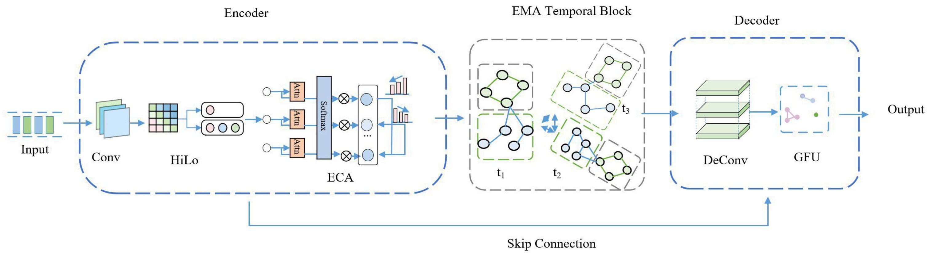
SMG-Net is built upon the three-stage video prediction framework of SimVP and consists of an Encoder, a Temporal Translator, and a Decoder. For radar echo extrapolation, the encoder is responsible for extracting spatial features from the input sequence in a hierarchical manner and performing downsampling-based compression; the temporal translator learns the dynamic evolution of the encoded features over time; and the decoder progressively reconstructs the latent temporal representations into future radar echo maps. The overall architecture of SMG-Net is shown in
Figure 1.
To address the problems of strong-echo attenuation, boundary blurring, and insufficient detail restoration during long-lead extrapolation, the following collaborative designs are introduced into the three-stage framework:
Encoding stage: A frequency–channel collaborative enhancement module (FCCE) is designed to improve multiscale structural representation in complex radar echo scenes through the joint use of HiLo-based frequency decoupling, 1 × 1 convolutional fusion, and ECA-based channel recalibration.
Temporal modeling stage: A trend–disturbance differentiated modeling mechanism based on moving-average decomposition and exponential moving average (EMA) is introduced to enhance temporal stability and alleviate error accumulation in long-term extrapolation.
Decoding stage: A gated fusion unit (GFU) is adopted to adaptively fuse high-level semantic features and shallow detailed features, thereby improving structural reconstruction and alleviating the underestimation of strong-echo intensity.
Through the above designs, SMG-Net improves structural preservation and long-range prediction stability in radar echo extrapolation while maintaining the high parallel efficiency of the original SimVP framework.
Among the above components, FCCE, trend–disturbance differentiated temporal modeling, and GFU constitute the three essential task-oriented modules of SMG-Net, corresponding to multiscale spatial enhancement, non-stationary temporal modeling, and adaptive structural recovery, respectively. Other architectural settings mainly follow the baseline SimVP configuration or support the implementation of these core modules. Unless otherwise stated, the main training hyperparameters were kept fixed across models to ensure a fair comparison, while architecture-specific settings were determined according to the requirements of each model.
2.2. Encoder Design
The quality of spatial representation directly affects the subsequent temporal modeling performance in radar echo extrapolation. For severe convective scenarios, the model is required not only to capture the large-scale morphology and displacement trend of echo systems, but also to preserve the fine-grained structural details around strong-echo cores and echo boundaries. If multiscale structures and key-channel responses are insufficiently represented in the encoding stage, boundary blurring and detail loss are more likely to occur during later temporal propagation and reconstruction.
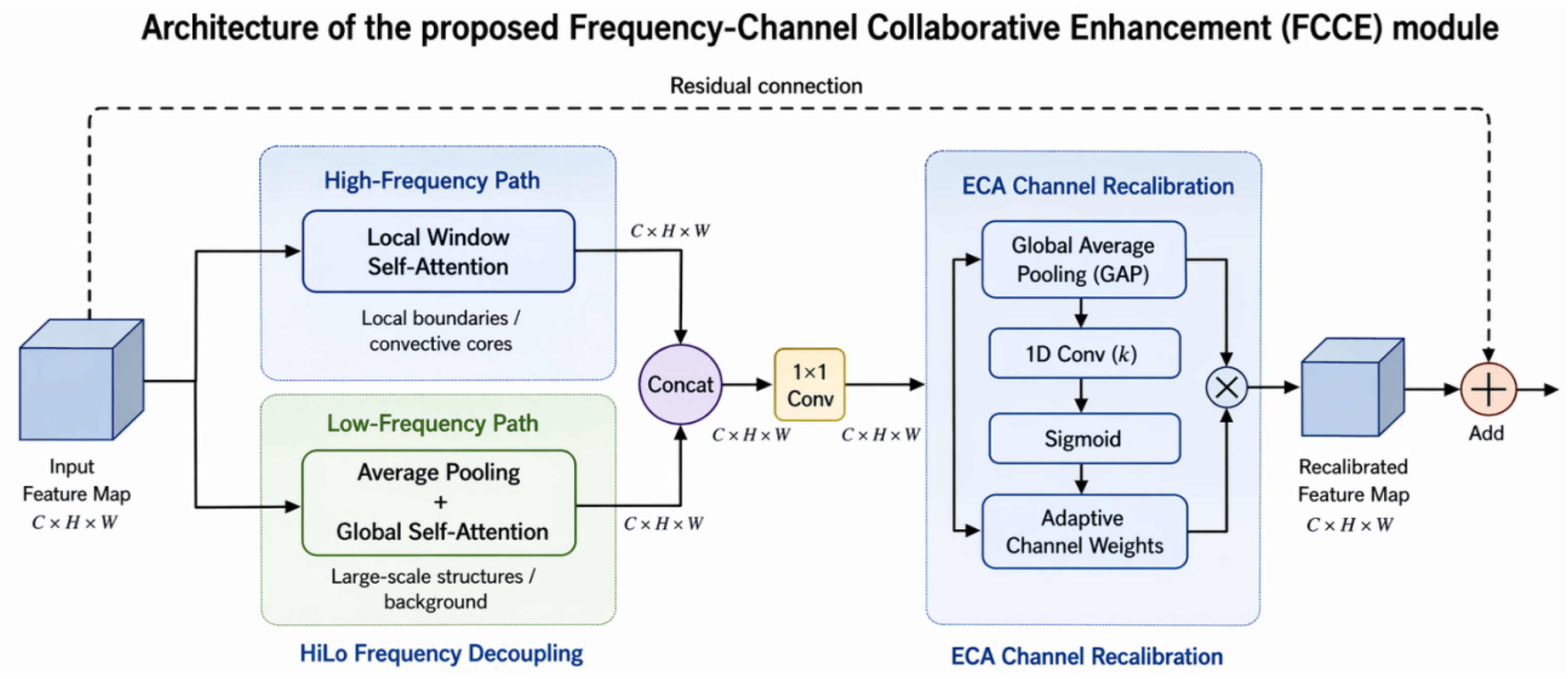
To this end, a Frequency–Channel Collaborative Enhancement (FCCE) module is introduced into the encoder. The module is embedded after each stage of convolutional feature extraction to jointly enhance multiscale structural representation and discriminative channel responses with limited additional computational cost. As shown in
Figure 2, FCCE consists of three components: HiLo-based frequency decoupling, 1 × 1 convolutional fusion, and ECA-based channel recalibration.
Let the encoded feature at a given stage be denoted as
where
C,
H, and
W denote the channel dimension, height, and width of the encoded feature map at the current stage, respectively.
First, FCCE performs high-/low-frequency differentiated modeling through the HiLo mechanism. The high-frequency branch employs local-window self-attention to capture sharp echo boundaries, convective cores, and local abrupt variations, whereas the low-frequency branch combines average pooling and global self-attention to model large-scale cloud morphology and background evolution. The outputs of the two branches are denoted as and , respectively. They are concatenated along the channel dimension to obtain the fused feature: .
Then, a 1 × 1 convolution is used for channel compression and feature fusion:
where
denotes the 1 × 1 convolutional mapping. This operation preserves the complementary information from the high- and low-frequency branches while restoring the feature dimension to a compact form.
On this basis, an ECA mechanism is further introduced to recalibrate channel responses. Specifically, global average pooling is first applied to
to obtain a channel descriptor, and a one-dimensional convolution is then used to model local inter-channel dependencies. The channel weights are generated by a sigmoid activation:
The fused feature is recalibrated channel-wise as:
where
denotes element-wise multiplication.
To avoid excessive suppression of the original feature information during enhancement, a residual connection is introduced at the output of FCCE:
Through this design, FCCE can simultaneously strengthen local high-frequency boundary information and large-scale low-frequency background information within the same feature level, while further emphasizing the channel responses that are most relevant to strong-echo evolution. Compared with simply cascading HiLo and ECA as independent modules, FCCE forms a collaborative encoding enhancement unit following the paradigm of frequency decoupling–channel fusion–channel recalibration, which is more suitable for multiscale structure preservation and strong-echo representation in radar echo extrapolation.
2.3. Trend–Disturbance Differentiated Temporal Modeling
Radar echo evolution exhibits pronounced non-stationary characteristics. Large-scale echo systems usually change smoothly and continuously, whereas the boundaries and core regions of severe convective echoes may vary rapidly in a localized manner. This suggests that the temporal evolution of the echo field can be approximately decomposed into a trend component and a disturbance component. Existing models generally perform temporal modeling directly in a unified feature space, making it difficult to simultaneously preserve global structural continuity and capture local abrupt variations, which often leads to gradual blurring of strong-echo regions in long-lead prediction. This decomposition-based view is consistent with the idea of separately modeling trend and fluctuation components in time-series forecasting [
20].
To address this issue, a trend–disturbance decoupled temporal modeling mechanism is introduced. Along the temporal dimension, the encoded feature is decomposed into a trend component and a disturbance component. The trend component is extracted by exponential moving average (EMA):
where
denotes the encoded feature at time step t,
denotes the trend feature, and
is the smoothing coefficient. The disturbance component is obtained by residual decomposition:
Therefore, the encoded feature can be represented as
The trend component mainly reflects the overall displacement and large-scale structural evolution of the echo field and usually shows strong temporal continuity, whereas the disturbance component preserves the boundary information of strong echoes and localized structural changes.
Based on this decomposition, the temporal translator models the trend and disturbance components separately and fuses them during decoding to reconstruct future features. By explicitly separating trend and disturbance variations, the model can preserve overall structural stability while enhancing the representation of strong-echo regions, thereby alleviating the structural degradation commonly observed in long-lead prediction. In contrast, unified temporal modeling tends to bias optimization toward the dominant smooth background, which weakens the representation of sparse but important strong-echo variations. After trend–disturbance separation, the trend branch maintains global displacement consistency and background continuity, whereas the disturbance branch focuses on local high-frequency changes, making it more effective in suppressing boundary blurring and high-value attenuation in strong-echo prediction.
2.4. Decoder Design
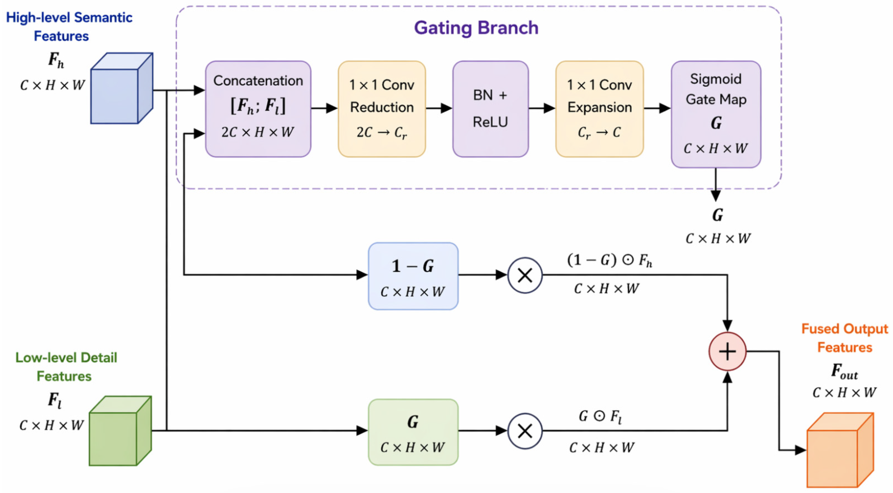
As shown in
Figure 3, the decoder progressively restores the spatial resolution through hierarchical upsampling and fuses the future trend/disturbance features from the temporal modeling stage with the skip connections from the encoder. To avoid the redundancy and noise introduced by simple addition or direct concatenation, a Gated Fusion Unit (GFU) is introduced to perform pixel-/channel-wise adaptive fusion:
where
denotes the decoder feature at the l-th level,
denotes the encoder skip connection at the same scale, and
∈ [0, 1] denotes the learned gating coefficient. In practice, the future trend feature and the skip connection are first used to form a reconstruction base, from which the gate coefficients are generated. The disturbance feature is then modulated by the gate and added to the base feature. In this way, the decoder maintains the consistency of large-scale trend information while injecting high-frequency detail corrections. After subsequent convolution and upsampling operations, the future radar echo frames are progressively reconstructed.
2.5. Loss Function Design
To address the non-stationary characteristics of radar echo sequences in high-dimensional space, this study introduces a Spatial–Temporal Loss (STLoss) inspired by Yang et al. [
21], which consists of a Weighted Mean Squared Error (WMSE) term and a Discrepancy Disentangled Regularization (DDR) term. Let the predicted sequence and the ground-truth sequence be denoted as
and
, respectively, where each frame contains
N pixels after flattening.
- (1)
Weighted Mean Squared Error (WMSE)
Different weights are assigned to different precipitation intensities (in dBZ) in order to emphasize strong echoes and alleviate the underestimation of high-intensity regions:
where the weight function is defined according to the ground-truth reflectivity level as:
This formulation increases the penalty on errors in strong-echo regions and encourages the model to better preserve high-value echo structures.
- (2)
Discrepancy Disentangled Regularization (DDR)
DDR measures the discrepancy between the temporal variation patterns of the predicted sequence and those of the ground-truth sequence. First, the frame-to-frame differences along the temporal dimension are computed for the prediction and the target, respectively. The resulting difference matrices are then flattened into one-dimensional vectors and transformed into probability distributions via the softmax function. Finally, the Kullback–Leibler (
KL) divergence is used to measure the discrepancy between the two distributions:
where
and
denote the flattened temporal-difference vectors of the prediction and the ground truth, respectively;
denotes the softmax function; and
denotes the
KL divergence.
- (3)
Spatial–Temporal Loss
The final loss is defined as:
where
and
are balancing coefficients for the two terms.
2.6. Data Source and Preprocessing
The experimental data used in this study were provided by the Institute of Plateau Meteorology, Sichuan Meteorological Bureau. The original radar data consist of three-dimensional volumetric reflectivity scans, with a spatial size of approximately 1955 × 2211 per scan and a total of 30 vertical layers. To represent the vertical structure of precipitation systems while controlling the computational cost, five radar layers, namely the 1st, 7th, 11th, 16th, and 22nd layers, were selected as the basic input channels. These layers provide a sparse but vertically distributed sampling of low-, middle-, and upper-level echo structures and were used to construct the multilayer radar echo prediction samples.
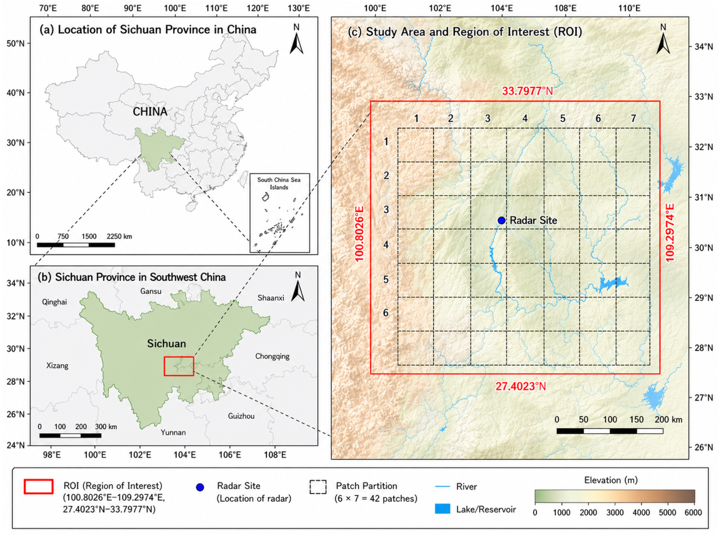
The region of interest (ROI) is defined by the latitude–longitude range [100.8026° E, 109.2974° E] × [27.4023° N, 33.7977° N]. The geographic location of the study area, the radar site, the ROI, and the 6 × 7 patch partition used for patch-based sample construction are shown in
Figure 4.
Before model training and evaluation, the radar reflectivity values (in dBZ) were linearly normalized to the range [0, 1] using Min–Max scaling. The clipping thresholds were set to 0 dBZ and 65 dBZ, respectively. No additional handcrafted denoising or clutter-removal procedure was applied in this study.
To adapt the data to the model input size while preserving both local details and global contextual information, a data construction strategy based on ROI patching with global auxiliary channels was adopted. Specifically, each sample consists of 20 consecutive frames arranged in chronological order, where the first 10 frames are used as input and the subsequent 10 frames are used as prediction targets. Samples were generated using a sliding-window strategy with a stride of 1.
For each frame, the ROI was partitioned into 6 × 7 = 42 patches of size 256 × 256. The patch size was chosen as a compromise among local convective-structure coverage, GPU memory consumption, and compatibility with the SimVP backbone. Boundary adjustment was applied at the ROI edges to maintain a constant patch size. For each patch at each time step, an 11-channel input tensor was constructed, including five local echo channels, five downsampled full-ROI channels of size 256 × 256 used to provide global contextual information, and one binary mask channel indicating the spatial location of the patch within the full ROI. This design was adopted to compensate for the loss of large-scale spatial context caused by patch-wise prediction.
The resulting patch-level input tensor is
where
B denotes the batch size. After prediction, all patch-level outputs were stitched back to the full ROI according to their fixed grid positions to reconstruct the full-frame radar echo maps.
To avoid temporal information leakage, the dataset was split strictly in chronological order. The first 70% of the generated samples (12,600 sequences) were used for training, and the remaining 30% (5400 sequences) were reserved for testing. The random seed was fixed to 1 to ensure reproducibility under the present experimental setting.
2.7. Experimental Settings
All experiments were conducted in Python 3.10.10 using PyTorch 1.12.1 with CUDA 11.3 on an NVIDIA GeForce RTX 3080 GPU. The random seed was fixed to 1. The model takes 10 historical frames as input and predicts the subsequent 10 frames, corresponding to 1 h radar echo extrapolation with a temporal resolution of 6 min. The input tensor size was 10 × 11 × 256 × 256.
For training, the batch size was set to 2 and the number of data-loading workers was set to 1. The hidden dimensions of the spatial and temporal modules were set to 64 and 256, respectively. The numbers of spatial and temporal blocks were set to 4 and 8, respectively, and the group number was set to 4. The model was trained for 2001 epochs using the Adam optimizer with an initial learning rate of 0.001. Unless otherwise specified, the main architectural and training hyperparameters were set with reference to the baseline SimVP configuration, while architecture-specific settings were determined according to the requirements of each model.
All comparison models were trained and evaluated under the same chronological data split, input–output setting, and forecasting horizon. The main training settings were kept as consistent as possible to ensure a fair comparison. Following the chronological data split described in
Section 2.6, all reported results were obtained on the held-out test set under the same fixed train–test split. In the present experimental setting, no separate validation subset was used for model selection. Therefore, all models were trained under the same fixed training protocol, and the reported results should be interpreted under this unified experimental setting. All reported results in the present study were obtained under a single chronological train–test split with a fixed random seed (seed = 1). Statistical stability across multiple random seeds or repeated data splits was not evaluated in the current experimental setting.
2.8. Evaluation Metrics
To comprehensively evaluate radar echo extrapolation performance in terms of both pixel-wise regression accuracy and strong-echo event prediction capability, this study adopts a combined evaluation framework consisting of continuous metrics and threshold-based event metrics. Let y denote the ground-truth reflectivity field and ŷ denote the corresponding model prediction. The temporal resolution of the data is 6 min, and the extrapolation horizon is 1 h, corresponding to T_out = 10 future frames. Unless otherwise stated, the continuous metrics (MSE and SSIM) were computed on the normalized reflectivity fields.
For threshold-based metrics, events are defined according to a reflectivity threshold
(unit: dBZ), for example,
r ≥
. When the input and output data are represented in normalized form, the dBZ threshold is mapped to the same numerical range through a linear transformation. In this study, the original reflectivity range was clipped to [0, 65] dBZ before normalization. Therefore, the converted threshold is defined as
- (1)
Structural Similarity Index (SSIM)
The Structural Similarity Index (SSIM) measures the similarity between two images from the perspectives of luminance, contrast, and structure. A larger SSIM value indicates higher structural similarity between the prediction and the ground truth. SSIM is defined as
where
and
denote the mean values of images x and y, respectively;
and
denote their variances; and
denotes the covariance.
- (2)
Mean Squared Error (MSE)
The Mean Squared Error (MSE) measures the average pixel-wise deviation between the prediction and the ground truth. A smaller MSE indicates better predictive performance. MSE is defined as
where
N denotes the total number of pixels.
- (3)
Threshold-Based Metrics
Considering that strong convection and heavy precipitation are usually associated with high-reflectivity regions and exhibit pronounced class imbalance, threshold-based metrics are further introduced to evaluate model performance from the perspective of event prediction. In this study, τ ∈ {10,20,30} dBZ is selected as the event threshold, and the event indicator function is defined pixel-wise as
Based on the pixel-wise confusion matrix, the four categories are defined as follows:
Using these quantities, the Critical Success Index (CSI), Probability of Detection (POD), and False Alarm Ratio (FAR) are defined as:
Among them, CSI comprehensively reflects hits, misses, and false alarms; POD measures the detection capability for target events; and FAR quantifies the proportion of false alarms among all predicted events. These metrics are particularly suitable for radar echo extrapolation tasks in which strong-echo regions are sparse and class imbalance is substantial.
3. Results and Discussion
3.1. Comparative Results
To evaluate the effectiveness of the proposed SMG-Net, comparative experiments were conducted against several representative models, including ConvLSTM, TrajGRU, PredRNN++, MIM, and SimVP. Unless otherwise specified, all models were trained and evaluated under the same chronological data split, input–output setting, forecasting horizon, and main training schedule described in
Section 2.7.
Table 1 summarizes the results in terms of both continuous metrics and threshold-based metrics on the test set. Although several more recent radar nowcasting models were discussed in the Introduction to position the latest methodological developments, the comparative study in this work was restricted to representative recurrent and efficient video prediction baselines under a unified experimental protocol.
As shown in
Table 1, SMG-Net achieves the best overall balance among the compared models under the present setting. In terms of continuous metrics, SMG-Net obtains the lowest MSE (0.032) and the highest SSIM (0.830), indicating that the proposed method reduces the overall regression error while better preserving the spatial structure of radar echoes. Compared with the baseline SimVP, SMG-Net reduces MSE from 0.042 to 0.032 and improves SSIM from 0.785 to 0.830. In terms of threshold-based metrics, CSI increases from 0.442/0.155/0.035 to 0.490/0.203/0.042 at the 10/20/30 dBZ thresholds, respectively. At 30 dBZ, POD increases from 0.034 to 0.045, while FAR decreases from 0.317 to 0.250. These results indicate that SMG-Net improves not only the overall regression accuracy but also the detection reliability of medium- and strong-echo regions.
Although some recurrent baselines, such as MIM and PredRNN++, remain competitive on individual metrics, SMG-Net provides the best overall balance across both continuous and threshold-based evaluations. The advantage becomes more evident at higher reflectivity thresholds, where strong-echo regions are sparse and more vulnerable to attenuation and structural blurring during long-lead extrapolation. In this sense, the improvements under the 20 and 30 dBZ thresholds are particularly meaningful for operational nowcasting, because these regions are more closely associated with intense convective activity and short-term warning demands.
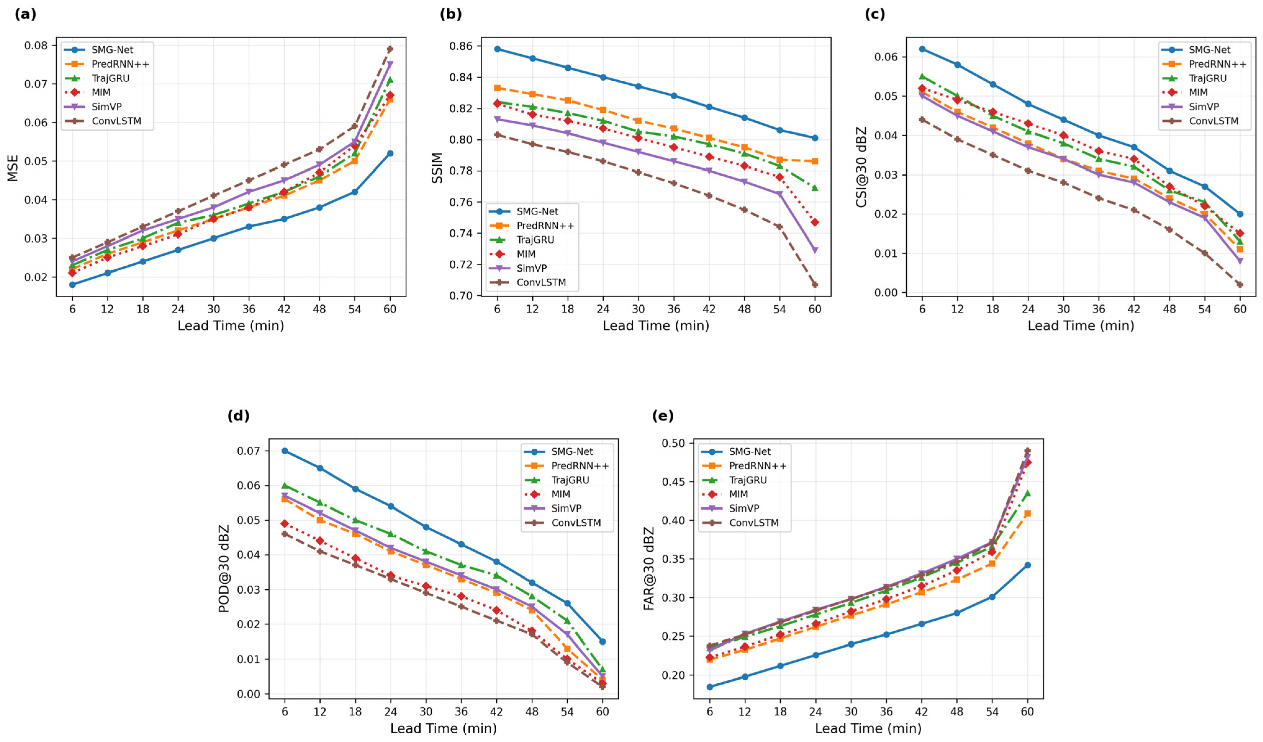
To further evaluate long-lead prediction stability, frame-wise metric -curves over the 1 h forecasting horizon are shown in
Figure 5. As the lead time increases, all models exhibit performance degradation; however, SMG-Net shows a slower increase in MSE and maintains more favorable SSIM, CSI@30 dBZ, POD@30 dBZ, and FAR@30 dBZ at later lead times. These results further support the effectiveness of the proposed model in preserving structural information, improving strong-echo detectability, and suppressing false alarms during longer lead-time extrapolation. It should be noted that
Figure 5 presents frame-wise performance at each forecast step, whereas the values in
Table 1 are aggregated over the full 1 h prediction horizon.
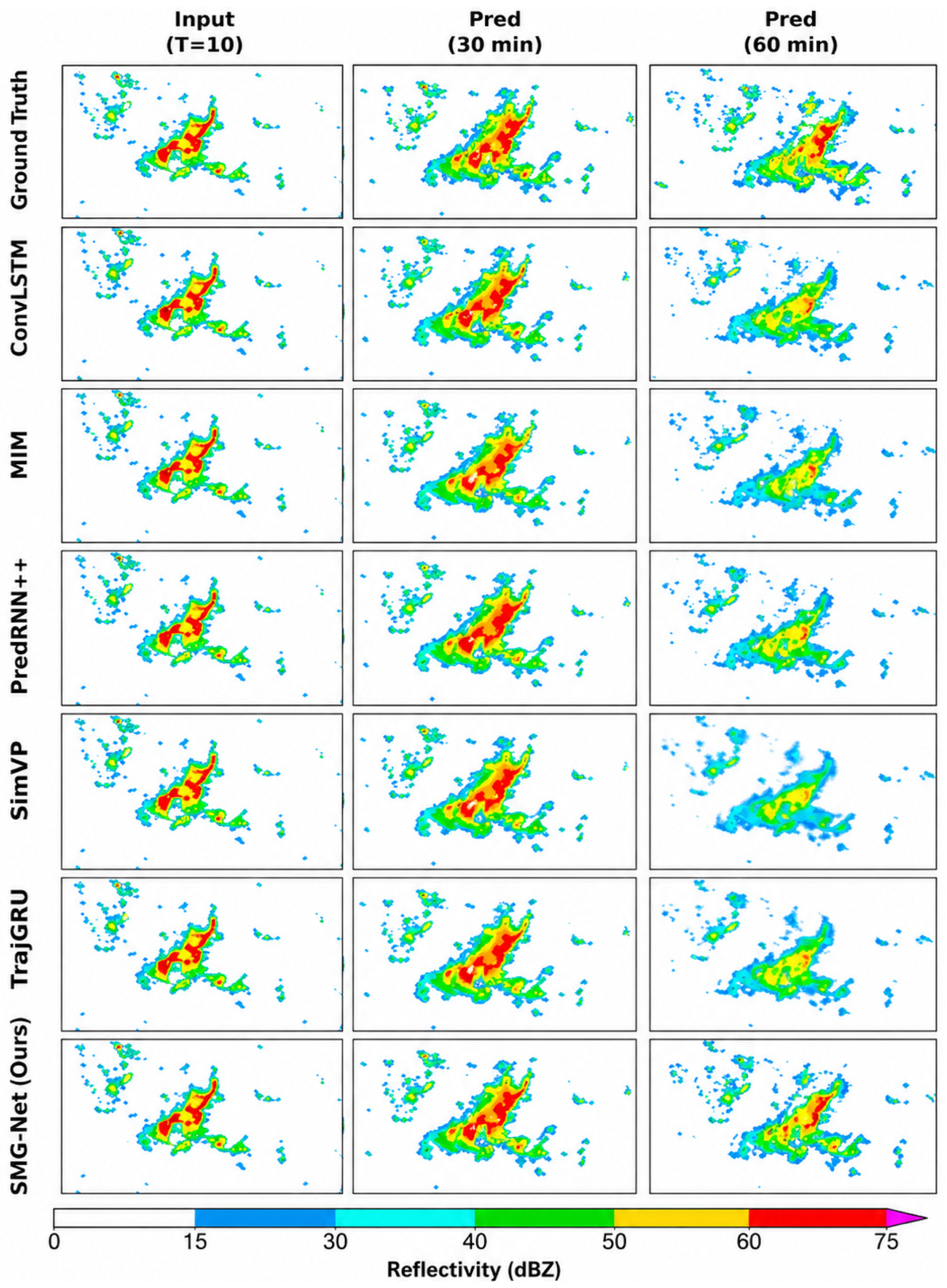
Figure 6 further provides qualitative comparisons of radar echo extrapolation results at different lead times. Compared with the baseline models, SMG-Net better preserves the spatial extent, boundary shape, and intensity distribution of strong-echo regions, especially at longer lead times. Although weak and scattered echoes remain difficult to reproduce accurately, the proposed model shows clearer advantages in maintaining the morphology and intensity of stronger convective echoes.
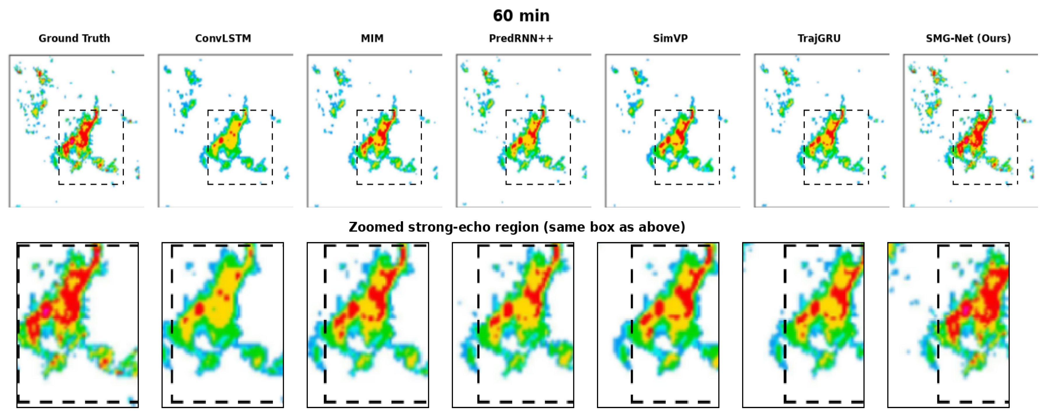
To further highlight the differences in strong-echo preservation,
Figure 7 presents a zoomed strong-echo region at 60 min using the same spatial box for all models. Compared with the baseline models, SMG-Net better preserves the core intensity and boundary structure of the strong-echo region, whereas several competing methods exhibit more pronounced attenuation or smoothing in the high-reflectivity core and surrounding transition zone. This case-based comparison provides more intuitive evidence that the proposed method is more effective in maintaining the morphology and intensity distribution of convective echoes at longer lead times.
These improvements are consistent with the design of the proposed framework. FCCE enhances the encoding of multiscale echo structures, especially strong-echo boundaries and local textures; the trend–disturbance differentiated temporal modeling improves temporal robustness by separating relatively smooth background evolution from localized rapid perturbations; and GFU strengthens the recovery of fine structures during decoding. The contribution of each module is further examined through the ablation experiments in
Section 3.2.
Table 2 compares the model complexity and runtime efficiency of different methods. Both SimVP and SMG-Net require substantially lower complexity and runtime cost than recurrent prediction models. Compared with the baseline SimVP, SMG-Net introduces only a modest increase in the number of parameters, FLOPs, inference time, and memory usage, while achieving more favorable predictive performance. This result indicates that the proposed method improves strong-echo prediction and structural preservation with limited additional computational overhead, while retaining the high parallel efficiency of the SimVP framework.
3.2. Ablation Results
Following the common practice of using ablation analysis to examine module-level contributions in deep-learning-based radar echo extrapolation studies [
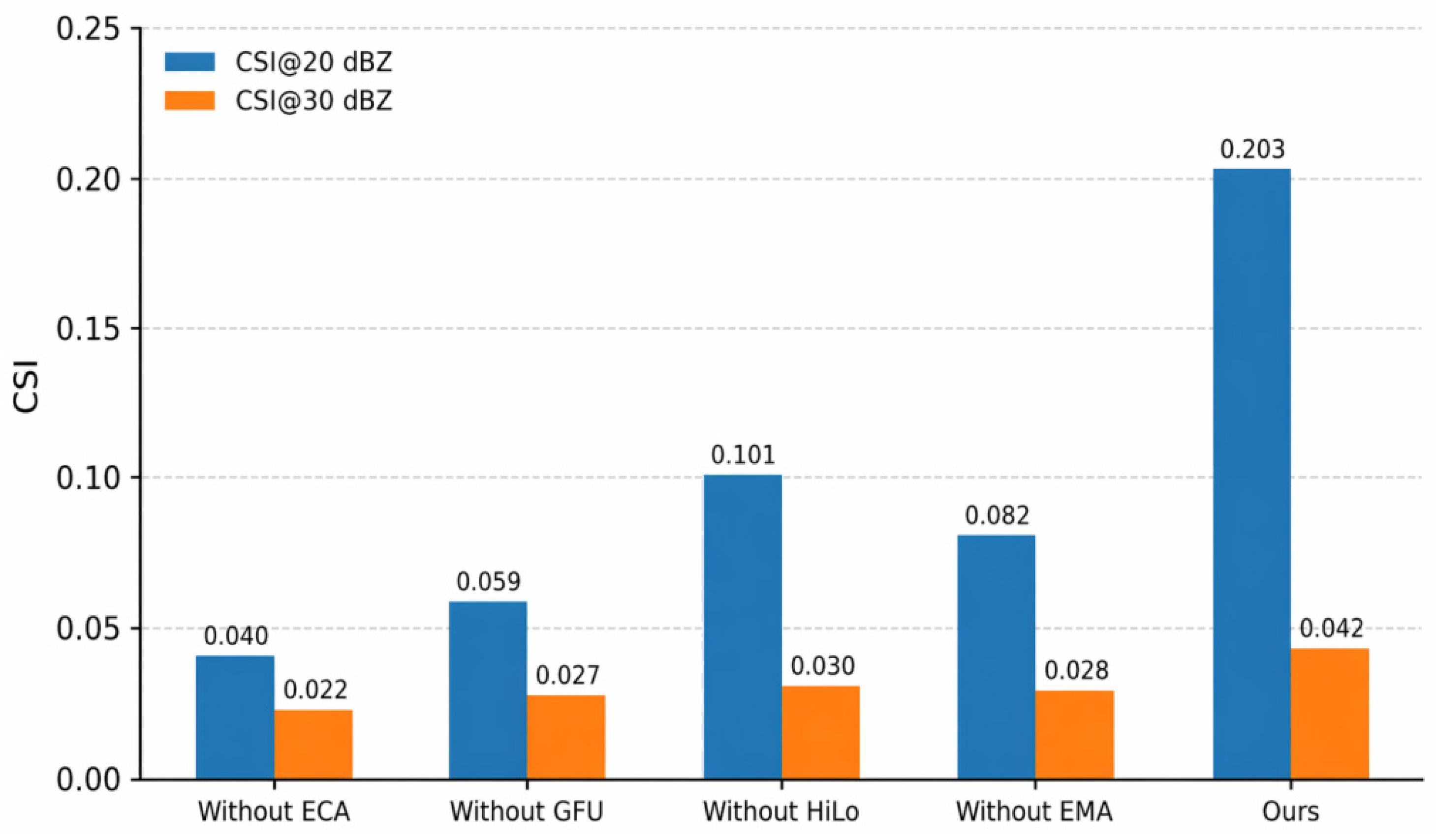
22], ablation experiments were conducted by removing the channel recalibration branch (ECA), the high-/low-frequency decoupling branch (HiLo), the gated fusion unit (GFU), and the EMA-based trend modeling module, respectively. All ablation experiments were performed under the same data split, training configuration, and evaluation pipeline as the main experiments, with only one component modified at a time to ensure a fair comparison. The evaluation was conducted for 1 h extrapolation, and CSI, POD, and FAR were calculated under thresholds of r ≥ 10 dBZ, r ≥ 20 dBZ, and r ≥ 30 dBZ. The results are listed in
Table 3 and further visualized in
Figure 8.
Overall, removing any of the four modules leads to performance degradation, which confirms that each component contributes positively to the final performance of SMG-Net. Moreover, the degradation is more pronounced under the 20 dBZ and 30 dBZ thresholds than under the 10 dBZ threshold, indicating that the proposed modules are particularly important for preserving medium- and strong-echo regions rather than only improving weak-echo coverage.
Among the ablated variants, removing ECA causes one of the most severe performance drops. At r ≥ 20 dBZ, CSI and POD decrease from 0.203/0.255 to 0.040/0.048, while FAR increases from 0.275 to 0.453. At r ≥ 30 dBZ, CSI and POD further decrease to 0.022/0.026. These results suggest that channel recalibration plays an important role in strengthening discriminative channel responses related to medium- and strong-echo regions and in suppressing false-alarm propagation.
Removing HiLo also leads to clear degradation at medium and high thresholds. At r ≥ 20 dBZ, CSI and POD decrease to 0.101/0.116, and at r ≥ 30 dBZ, they decrease to 0.030/0.031, accompanied by an increase in FAR. This indicates that joint high-/low-frequency modeling is beneficial for preserving echo boundaries and localized strong-core structures, thereby mitigating the over-smoothing and structural blurring commonly observed in long-lead extrapolation.
Removing GFU results in a systematic decline across all thresholds. For example, at r ≥ 20 dBZ and r ≥ 30 dBZ, CSI/POD decrease to 0.059/0.067 and 0.027/0.028, respectively, while FAR increases to 0.375 and 0.310. These results show that the gated fusion mechanism plays an important role in cross-level feature interaction by enhancing useful detail injection while suppressing noisy or redundant responses during decoding.
Removing EMA also causes substantial degradation, especially under the r ≥ 20 dBZ threshold, where CSI/POD decrease from 0.203/0.255 to 0.082/0.095 and FAR increases from 0.275 to 0.412. At r ≥ 30 dBZ, CSI/POD decrease to 0.028/0.029. This confirms that EMA-based trend modeling is important for improving temporal consistency and alleviating structural drift caused by error accumulation during long-lead extrapolation.
Taken together, the ablation results demonstrate that the performance gain of SMG-Net does not originate from a single isolated component. Instead, the final improvement is achieved through the coordinated effect of channel enhancement, frequency-aware structural modeling, gated multilevel fusion, and temporally stabilized trend modeling. This is consistent with the design objective of the proposed framework, namely, to improve strong-echo preservation and long-lead prediction stability through a collaborative multistage design.
3.3. Discussion
The results indicate that the main advantage of SMG-Net lies not only in reducing the overall prediction error, but also in improving the preservation of medium- and strong-echo structures at longer lead times. This is particularly reflected in the improvements under the 20 dBZ and 30 dBZ thresholds, where strong-echo attenuation and structural blurring are more pronounced for the baseline models. From an application-oriented perspective, these improvements are meaningful because medium- and strong-echo regions are more closely associated with intense convective activity and short-term warning demands. Therefore, the observed gains in CSI, POD, and FAR at higher thresholds suggest that the proposed model is more effective in maintaining convective echo morphology and event detectability in operationally relevant regions.
From a methodological perspective, these improvements are closely related to the collaborative design of the proposed framework. FCCE enhances multiscale spatial representation by strengthening both local high-frequency details and large-scale low-frequency structures, which is beneficial for preserving strong-echo cores and boundary information. The trend–disturbance differentiated temporal modeling improves temporal robustness by separating relatively smooth background evolution from localized rapid perturbations, thereby alleviating the error accumulation and structural drift commonly observed in long-lead extrapolation. GFU further improves structural recovery during decoding through adaptive hierarchical feature fusion. The coordinated effect of these components helps explain why the full model consistently outperforms the ablated variants, especially under medium- and high-threshold evaluations.
Nevertheless, several limitations should be noted. Although SMG-Net improves the prediction of medium- and strong-echo regions, the reproduction of weak and scattered echoes is still limited. In addition, the experiments were conducted on a single regional radar dataset, and the generalization ability of the model under different climatic regimes and weather conditions still requires further validation. Moreover, the current experiments were carried out under a single chronological train–test split with a fixed random seed and without a separate validation subset for model selection. Previous studies have emphasized that variance from data sampling, parameter initialization, and hyperparameter choices may affect the reliability of machine-learning benchmark comparisons [
23]. Therefore, statistical stability across multiple random seeds or repeated data splits was not evaluated in the present study. Future work will therefore focus on multisource meteorological information fusion, cross-region generalization evaluation, more rigorous validation protocols, and longer lead-time radar echo extrapolation. In particular, future studies will consider extending the framework to public dual-polarization radar datasets such as NJU-CPOL and incorporating additional physical variables, such as
ZDR and
KDP, to improve cross-region generalization and enrich the representation of convective microphysical structures [
24,
25].
4. Conclusions
In this study, we proposed SMG-Net, a SimVP-based radar echo extrapolation model for mitigating strong-echo attenuation, boundary blurring, and performance degradation in long-lead prediction. The proposed framework improves radar echo extrapolation through the coordinated design of multiscale spatial enhancement, trend–disturbance differentiated temporal modeling, and gated hierarchical feature fusion.
Experimental results demonstrate that SMG-Net achieves the best overall balance among the compared models under the present setting. Compared with the baseline SimVP, the proposed model improves both continuous and threshold-based performance while introducing only limited additional computational cost, thereby retaining the high parallel efficiency of the SimVP framework. These results indicate that the performance gain is not only reflected in lower overall prediction error, but also in better event-level detection of medium- and strong-echo regions.
More importantly, SMG-Net shows clearer advantages in preserving the morphology, boundary structure, and intensity distribution of medium- and strong-echo regions at longer lead times. This suggests that the coordinated spatial–temporal–decoding design is effective for alleviating strong-echo attenuation and structural smoothing in efficient radar echo extrapolation. Therefore, the proposed framework has practical value for short-term precipitation nowcasting in severe convective scenarios.
Future work will focus on improving weak-echo representation, adopting more rigorous validation protocols, extending the prediction horizon, and enhancing cross-region generalization through multisource meteorological information fusion.