
Spatiotemporal Patterns of Hongshan Culture Settlements in Relation to Middle Holocene Climatic Fluctuation in the Horqin Dune Field, Northeast China


Abstract
1. Introduction
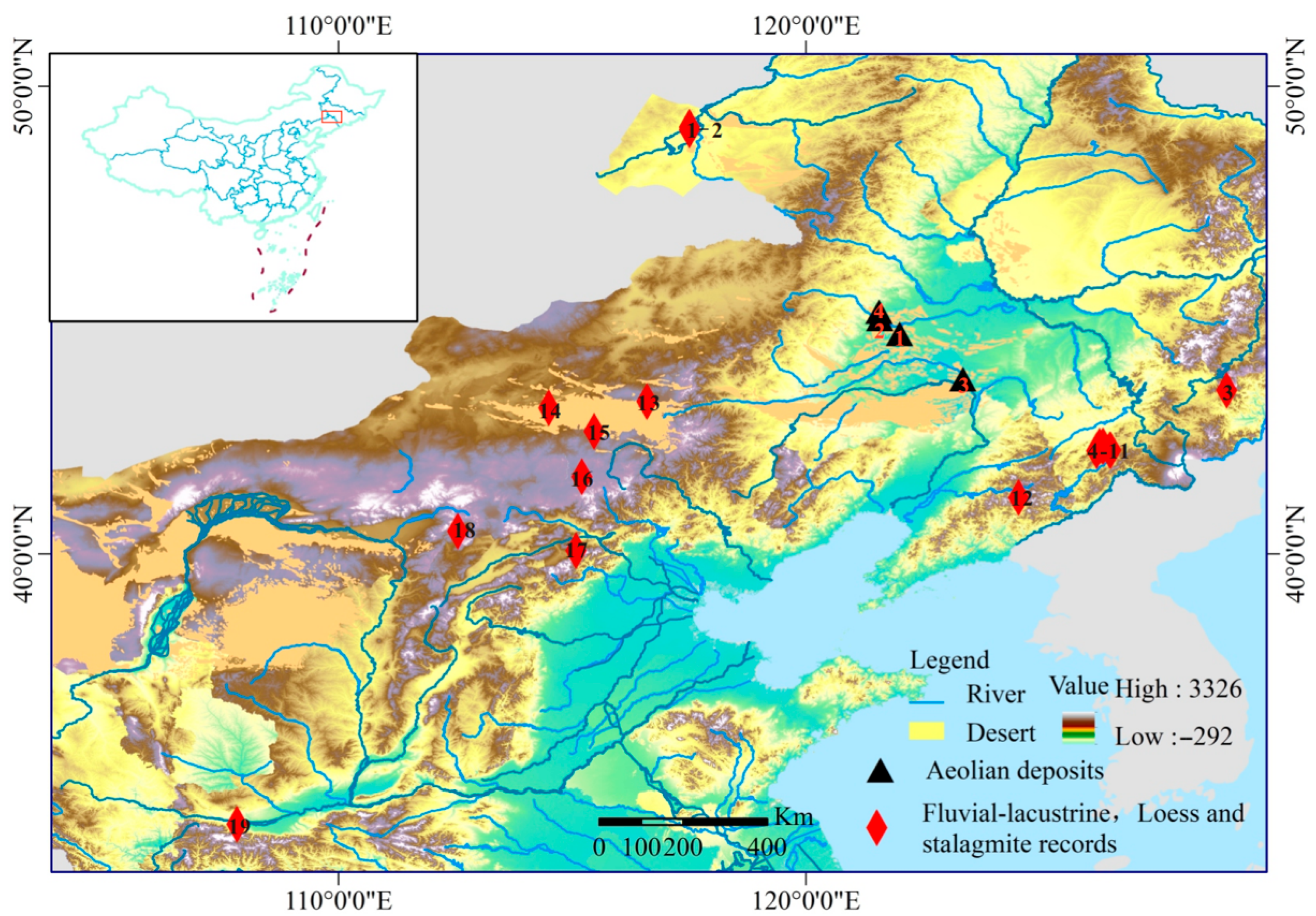
2. Study Areas
3. Material and Methods
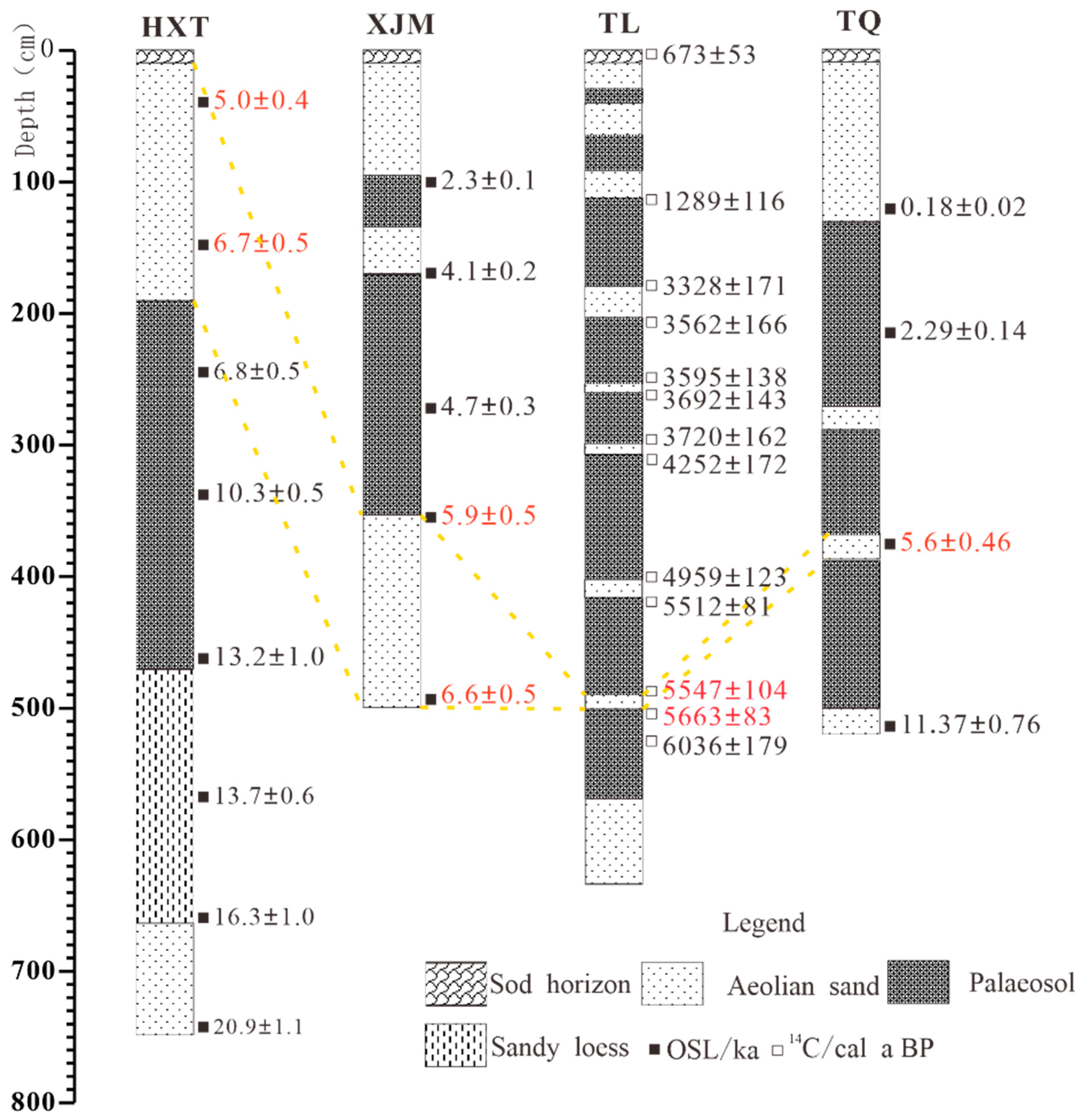
3.1. Synthesis of Holocene Aeolian Dated Records from the Horqin Dune Field
3.2. Synthesis of Other Proxy Records in Northeastern China and Adjacent Regions
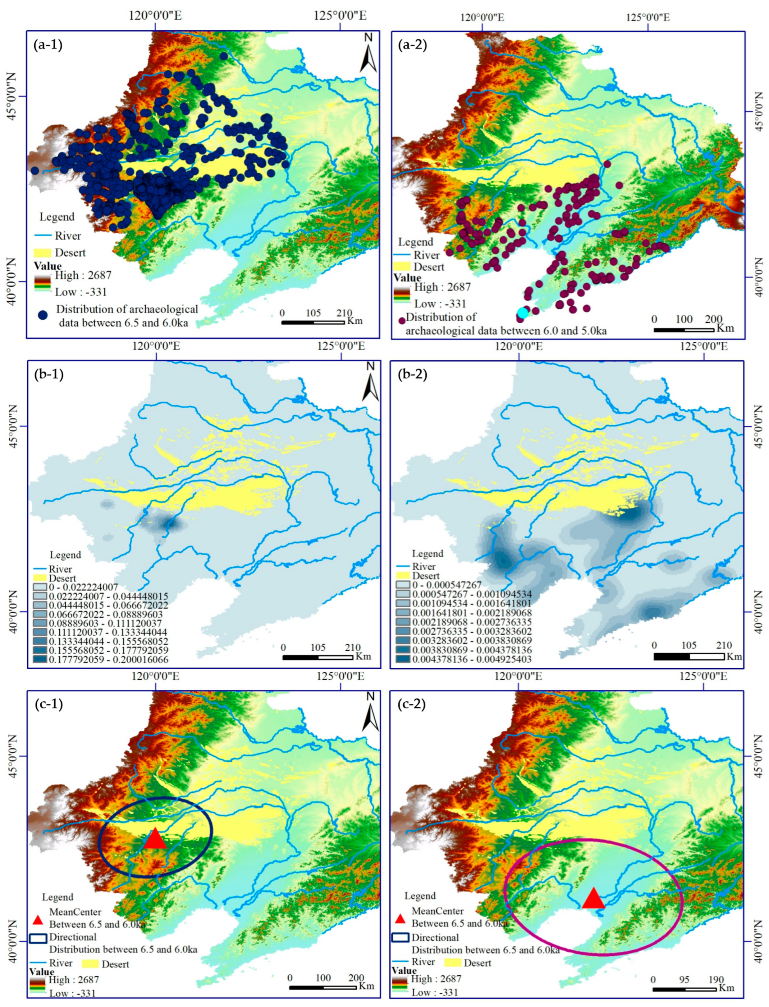
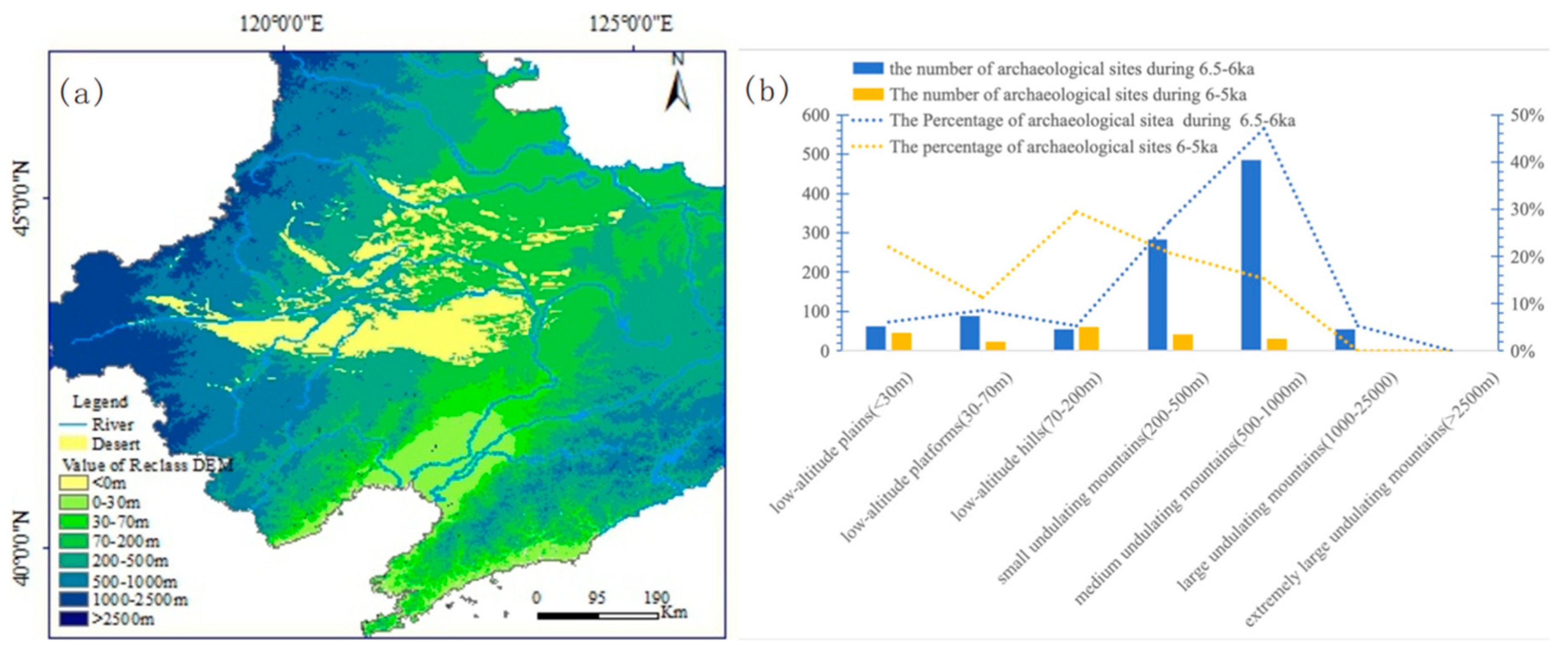
3.3. Archaeological Data: Sources and Mapping
- (1)
- Kernel Density Analysis: Using the “Kernel Density Analysis” tool in ArcGIS 10.8, with a search radius set to 5 km, kernel density analysis was conducted on the early (6.5–6.0 ka) and middle-late (6.0–5.0 ka) Hongshan Culture archaeological sites in the study area to reflect the continuity of site density changes. A higher kernel density value indicates greater point concentration [62].
- (2)
- Directional Distribution: The directional distribution describes quantitatively and qualitatively the spatial characteristics of archaeological sites, including centrality and directionality. Parameters such as the mean center, semi-major/minor axes, and directional angle visually depict geographic elements. The movement of the mean center indicates the overall directional shift. The major axis represents the distribution direction of cultural sites, and the minor axis indicates dispersion [63,64].
- (3)
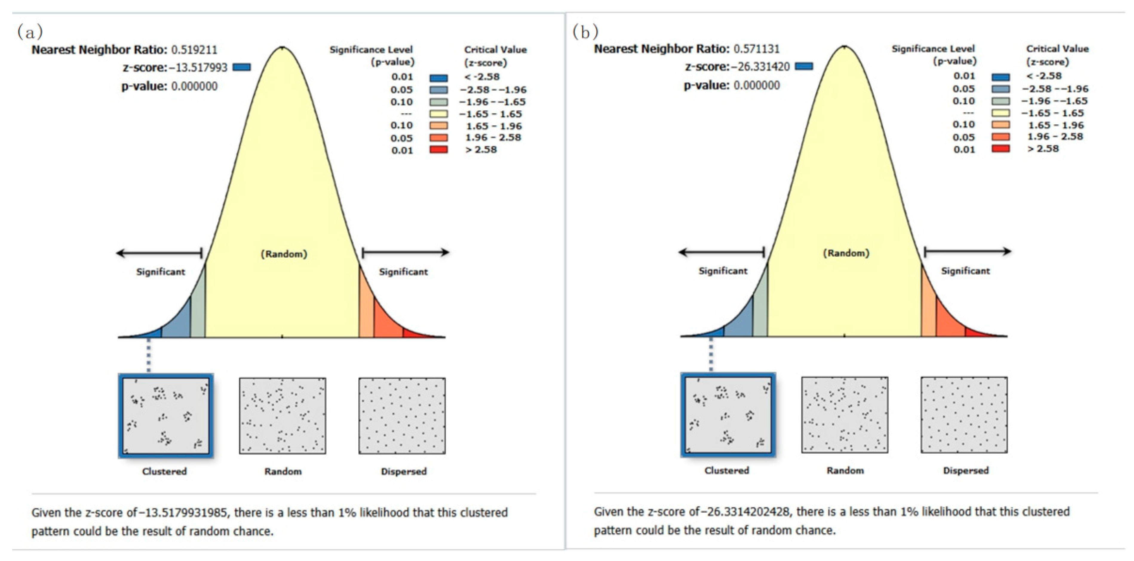
- Average Nearest Neighbor: The average nearest neighbor analysis evaluates the spatial distribution pattern of sites by comparing the ratio of the observed average distance between each site and its nearest neighbor to the expected average distance. This effectively reflects the spatial distribution features of the sites [65].
- (4)
- (5)
- (6)
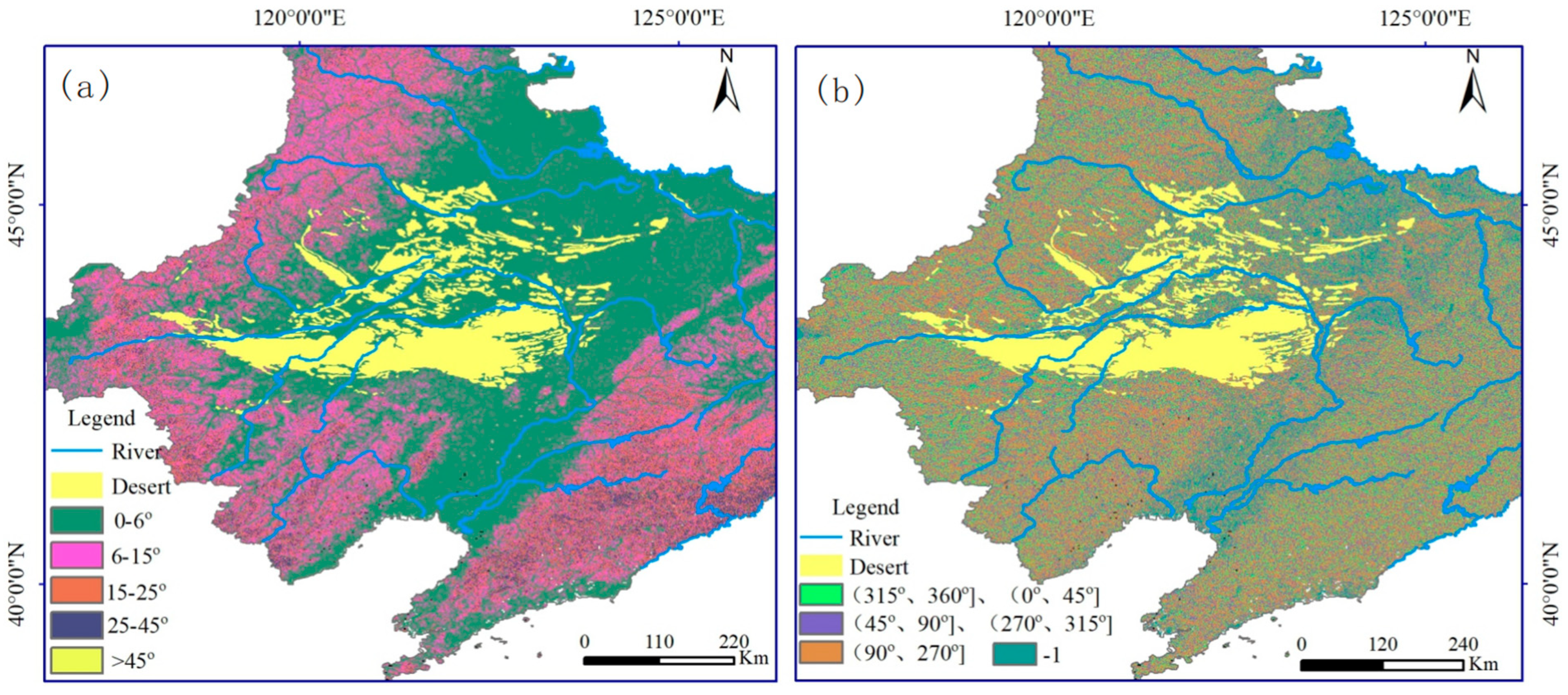
- Aspect: For archaeological sites, the aspect refers to the horizontal angle between the projected normal vector of a slope and true north (0°/360°). ArcGIS 10.8’s default aspect classification includes nine categories. Each interval spans 45° (excluding flat areas), measured clockwise. For further analysis, aspects were reclassified into high sunlight exposure, moderate sunlight exposure, low sunlight exposure, and poor sunlight exposure [66,67].
4. Results
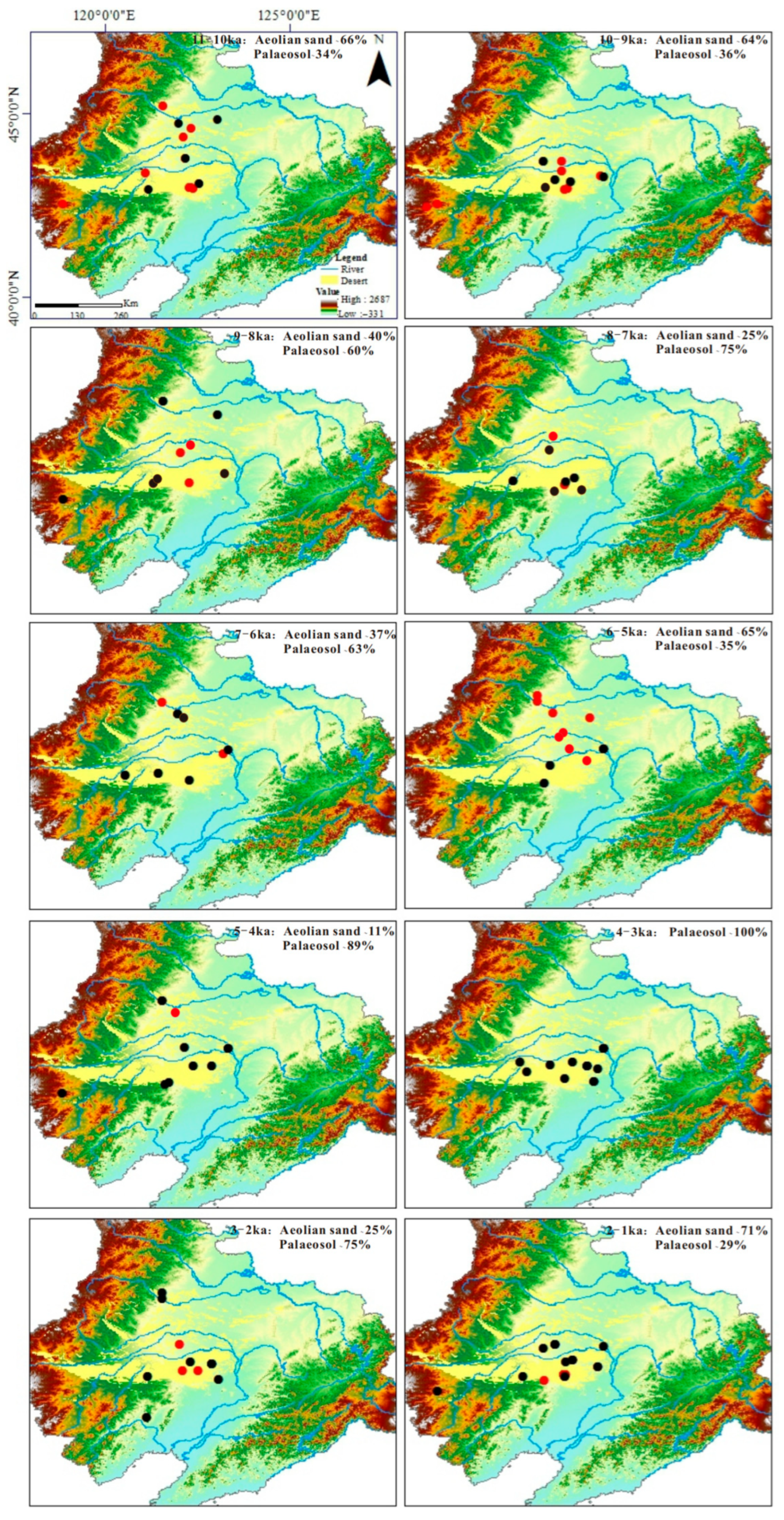
4.1. Climatic Fluctuation During 6.5–5.0 ka Indicated by Aeolian Deposits in Horqin Dune Field
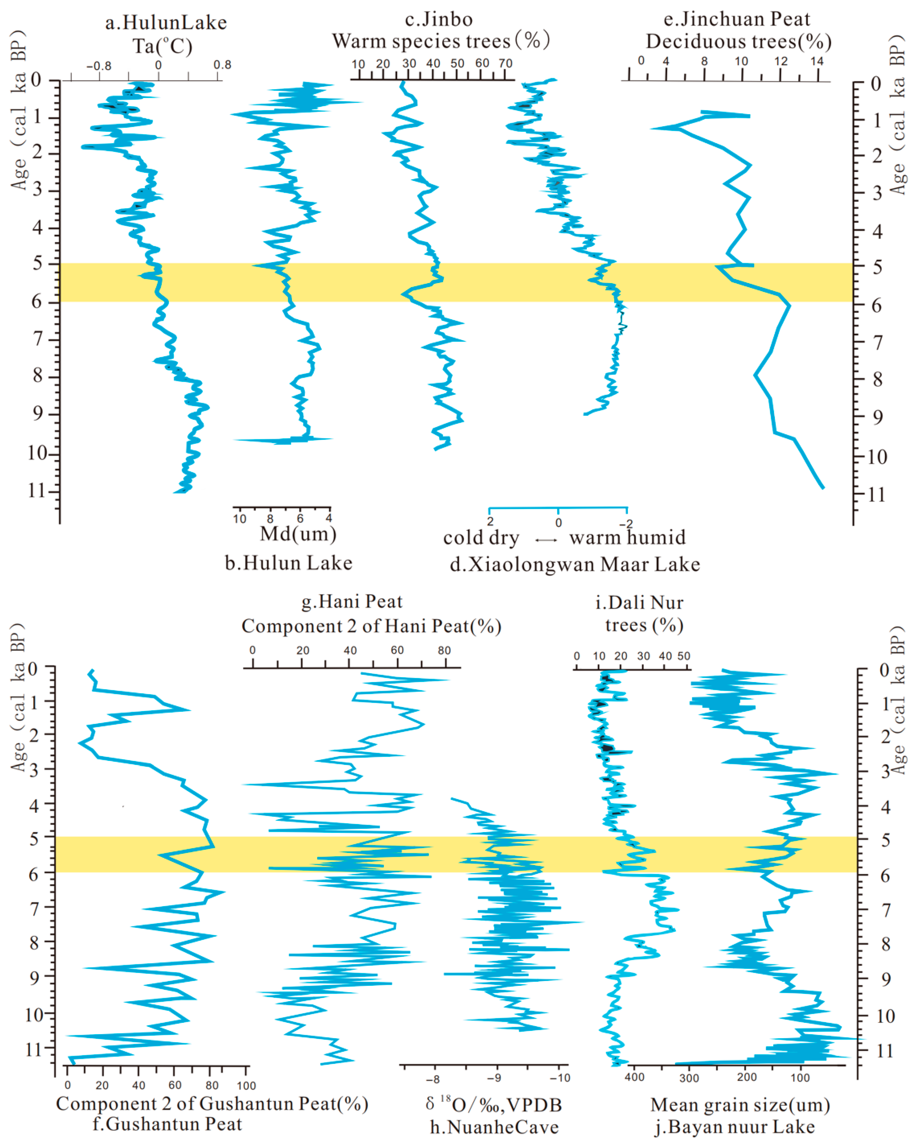
4.2. Climatic Fluctuation During 6.0–5.0 ka Indicated by Other Records in Northeastern China and Adjacent Regions
4.3. Spatiotemporal Pattern of Hongshan Culture Archaeological Sites
5. Discussion
5.1. The Influence of Climatic Fluctuation on Spatiotemporal Patterns of HongShan Settlements
5.2. The Influence of Climatic Fluctuation on Survival Strategy of Hongshan Settlements
6. Conclusions
Supplementary Materials
Author Contributions
Funding
Institutional Review Board Statement
Informed Consent Statement
Data Availability Statement
Acknowledgments
Conflicts of Interest
Abbreviations
| ASMB | Asian summer monsoonal boundary |
| OSL | optically stimulated luminescence |
References
- Overpeck, J.; Webb, R. Nonglacial rapid climate events: Past and future. Proc. Natl. Acad. Sci. USA 2000, 97, 1335–1338. [Google Scholar] [CrossRef] [PubMed]
- Wu, W.; Liu, T. Possible role of the “Holocene Event 3” on the collapse of Neolithic cultures around the Central Plain of China. Quat. Int. 2004, 117, 153–166. [Google Scholar] [CrossRef]
- Kuper, R.; Kröpelin, S. Climate-controlled Holocene occupation in the Sahara: Motor of Africa’s evolution. Science 2006, 313, 803–807. [Google Scholar] [CrossRef] [PubMed]
- Weiss, H. Global megadrought, societal collapse and resilience at 4.2–3.9 Ka BP across the Mediterranean and West Asia. Past Glob. Changes Mag. 2016, 24, 62–63. [Google Scholar] [CrossRef]
- Dong, G.; Liu, F.; Chen, F. Environmental and technological effects on ancient social evolution at different spatial scales. Sci. China Earth Sci. 2017, 60, 2067–2077. [Google Scholar] [CrossRef]
- Brooks, N. Cultural responses to aridity in the Middle Holocene and increased social complexity. Quat. Int. 2006, 151, 29–49. [Google Scholar] [CrossRef]
- Haug, G.H.; Günther, D.; Peterson, L.C.; Sigman, D.M.; Hughen, K.A.; Aeschlimann, B. Climate and the collapse of Maya civilization. Science 2003, 299, 1731–1735. [Google Scholar] [CrossRef] [PubMed]
- Hou, M.; Wu, W.X. A review of 6000–5000 cal BP climatic anomalies in China. Quat. Int. 2021, 571, 58–72. [Google Scholar] [CrossRef]
- Bond, G.; Kromer, B.; Beer, J.; Muscheler, R.; Evans, M.N.; Showers, W.; Hoffmann, S.; Lotti-Bond, R.; Hajdas, I.; Bonani, G. Persistent solar influence on North Atlantic climate during the Holocene. Science 2001, 294, 2130–2136. [Google Scholar] [CrossRef] [PubMed]
- Mayewski, P.A.; Rohling, E.E.; Stager, J.C.; Karlén, W.; Maasch, K.A.; Meeker, L.D.; Meyerson, E.A.; Gasse, F.; van Kreveld, S.; Holmgren, K.; et al. Holocene climate variability. Quat. Res. 2004, 62, 243–255. [Google Scholar] [CrossRef]
- Magny, M.; Haas, J.N. A major widespread climatic change around 5300 cal. yr BP at the time of the Alpine Iceman. J. Quat. Sci. 2004, 19, 423–430. [Google Scholar] [CrossRef]
- Morrill, C.; Overpeck, J.T.; Cole, J.E. A synthesis of abrupt changes in the Asian summer monsoon since the last deglaciation. Holocene 2003, 13, 465–476. [Google Scholar] [CrossRef]
- Huang, K.; Xie, D.; Chen, C.; Tang, Y.; Wan, Q.; Zhang, X. An environmental crisis and its cultural impact in Eastern China around 6000 years ago. Palaeogeogr. Palaeocl. 2023, 624, 111670. [Google Scholar] [CrossRef]
- Xu, D.; Lu, H.; Chu, G.; Liu, L.; Shen, C.; Li, F.; Wang, C.; Wu, N. Synchronous 500-year oscillations of monsoon climate and human activity in Northeast Asia. Nat. Commun. 2019, 10, 4105. [Google Scholar] [CrossRef] [PubMed]
- Xue, W.; Jin, H.; Liu, B.; Sun, L.; Liu, Z. The possible stimulation of the mid-Holocene period’s initial hydrological recession on the development of Neolithic cultures along the margin of the East Asian summer monsoon. Sustainability 2019, 11, 2106. [Google Scholar] [CrossRef]
- Hassan, F.A. Nile floods and political disorder in Early Egypt. NATO ASI Ser. I Glob. Environ. Change 1996, 16, 1–18. [Google Scholar]
- Dalfes, H.N.; Kukla, G.; Weiss, H. Late Third Millennium Abrupt Climate Change and Social Collapse in West Asia and Egypt. In Third Millennium BC Climate Change and Old World Collapse; Springer: Berlin/Heidelberg, Germany, 1997; pp. 711–723. [Google Scholar]
- Li, Y.Y.; Willis, K.J.; Zhou, L.P.; Cui, H.T. The impact of ancient civilization on the northeastern Chinese landscape: Palaeoecological evidence from the western Liaohe River Basin, Inner Mongolia. Holocene 2006, 16, 1109–1121. [Google Scholar] [CrossRef]
- Jia, X.; Sun, Y.; Wang, L.; Sun, W.; Zhao, Z.; Lee, H.F.; Huang, W.; Wu, S.; Lu, H. The transition of human subsistence strategies in relation to climate change during the Bronze Age in the West Liao River Basin, Northeast China. Holocene 2016, 26, 781–789. [Google Scholar] [CrossRef]
- Guo, L.; Xiong, S.; Ding, Z.; Jin, G.; Wu, J.; Ye, W. Role of the mid-Holocene environmental transition in the decline of Late Neolithic cultures in the deserts of NE China. Quat. Sci. Rev. 2018, 190, 98–113. [Google Scholar] [CrossRef]
- Cao, C. Review of the study on the stages of Hongshan Culture since the new century. J. Chifeng Univ. Soc. Sci. 2022, 43, 4. [Google Scholar]
- Li, Z. Research on Periodization of Hongshan Culture. Master’s Thesis, Wuhan University, Wuhan, China, 2022. [Google Scholar]
- Gao, Y. Cultural Evolution and Social Development in Northeast China Before 3000 BC. Ph.D. Thesis, Jilin University, Changchun, China, 2021. [Google Scholar]
- Teng, H. Production technology and economic structure in Hongshan Culture period. J. Chifeng Univ. Soc. Sci. 2017, 38, 5. [Google Scholar]
- Chen, Z. The Settlement Changes in the Neolithic Age and the Early Society in Liaoxi Area. Ph.D. Thesis, Jilin University, Changchun, China, 2019. [Google Scholar]
- Yang, Z. On the character of the city-site of the Yangshao Culture at Xishan, Zhengzhou. HuaXia Archaeol. 1997, 1, 55–59. [Google Scholar]
- Gao, J.Y.; Hou, G.L.; Lancuo, Z.; Zhu, Y.; Hou, X.Q. Spatiotemporal evolution and environmental change of ancient sites in Hexi Corridor. J. Earth Environ. 2019, 10, 12–16. [Google Scholar]
- Jia, X.; Yi, S.; Sun, Y.; Wu, S.; Lee, H.F.; Wang, L.; Lu, H. Spatial and temporal variations in prehistoric human settlement and their influencing factors on the south bank of the Xar Moron River, Northeastern China. Front. Earth Sci. 2017, 11, 137–147. [Google Scholar] [CrossRef]
- Lin, W.; Xin, J.; Hong, W. Study on the temporal-spatial evolution of prehistoric settlements and its correlation with subsistence strategy and climate history in the Western Liao River area. Adv. Earth Sci. 2016, 31, 1159. [Google Scholar]
- Wang, J. The Evolution of Human Living Environment During the Holocene and Its Influence on Prehistoric Human Activities in the Songliao Plain. Ph.D. Thesis, Northeast Normal University, Changchun, China, 2022. [Google Scholar]
- Hosner, D.; Wagner, M.; Tarasov, P.E.; Chen, X.; Leipe, C. Spatiotemporal distribution patterns of archaeological sites in China during the Neolithic and Bronze Age: An overview. Holocene 2016, 26, 1576–1593. [Google Scholar] [CrossRef]
- Gao, S.; Cheng, W.; Jin, H.; Dong, G.; Li, B.; Yang, G.; Liu, L.; Guan, Y.; Sun, Z.; Jin, J. Preliminary study on the desert changes at the northwest edge of China. Sci. China Ser. 1993, 23, 202–208. [Google Scholar]
- Xiao, J.; Chang, Z.; Wen, R.; Zhai, D. Holocene weak monsoon intervals indicated by low lake levels at Hulun Lake in the monsoonal margin region of Northeastern Inner Mongolia, China. Holocene 2009, 19, 899–908. [Google Scholar] [CrossRef]
- Liu, H.; Yin, Y.; Zhu, J.; Zhao, F.; Wang, H. How did the forest respond to Holocene climate drying at the forest-steppe ecotone in Northern China? Quat. Int. 2010, 227, 46–52. [Google Scholar] [CrossRef]
- Li, C.; Wu, Y.; Hou, X. Holocene vegetation and climate in Northeast China revealed from Jingbo Lake sediment. Quat. Int. 2011, 229, 67–73. [Google Scholar] [CrossRef]
- Liu, Y.; Zhang, S.; Liu, J. Vegetation and environment history of Erlongwan Maar Lake during the Late Pleistocene on pollen record. Acta Micropalaeontol. Sin. 2008, 25, 274–280. [Google Scholar]
- You, H.; Liu, J. High-resolution climate evolution derived from the sediment records of Erlongwan Maar Lake since 14 Ka BP. Chin. Sci. Bull. 2012, 57, 3610–3616. [Google Scholar] [CrossRef]
- Jiang, W.; Leroy, S.A.G.; Ogle, N.; Chu, G.; Wang, L.; Liu, J. Natural and anthropogenic forest fires recorded in the Holocene pollen record from a Jinchuan peat bog, Northeastern China. Palaeogeogr. Palaeocl. 2008, 261, 47–57. [Google Scholar] [CrossRef]
- Li, N.; Chen, F.; Yang, J.; Jie, D.; Liu, L.; Liu, H.; Gao, G.; Gao, Z.; Li, D.; Shi, J.; et al. Records of East Asian monsoon activities in Northeastern China since 15.6 ka, based on grain size analysis of peaty sediments in the Changbai Mountains. Quat. Int. 2018, 447, 158–169. [Google Scholar] [CrossRef]
- Hong, Y.T.; Hong, B.; Lin, Q.H.; Shibata, Y.; Hirota, M.; Zhu, Y.X.; Leng, X.T.; Wang, Y.; Yi, L. Inverse phase oscillations between the East Asian and Indian Ocean summer monsoons during the last 12000 years and paleo-El Niño. Earth Planet. Sci. Lett. 2005, 231, 337–346. [Google Scholar] [CrossRef]
- Zheng, Y.; Pancost, R.D.; Liu, X.; Wang, Z.; Naafs, B.D.A.; Xie, X.; Yi, W.; Zhou, W. Atmospheric connections with the North Atlantic enhanced the deglacial warming in Northeast China. Geology 2017, 45, 1031–1034. [Google Scholar] [CrossRef]
- Wu, J.; Wang, Y.; Dong, J. Changes in East Asian summer monsoon during the Holocene recorded by stalagmite δ18O records from Liaoning Province. Quat. Sci. 2011, 31, 990–998. [Google Scholar]
- Wen, R.; Xiao, J.; Fan, J.; Zhang, S.; Yamagata, H. Pollen evidence for a mid-Holocene East Asian summer monsoon maximum in Northern China. Quat. Sci. Rev. 2017, 176, 29–35. [Google Scholar] [CrossRef]
- Ming, G.; Zhou, W.; Wang, H.; Cheng, P.; Shu, P.; Xian, F.; Fu, Y.; Du, H. Moisture variations in lacustrine-eolian sequence from the Hunshandake Sandy Land associated with the East Asian summer monsoon changes since the Late Pleistocene. Quat. Sci. Rev. 2020, 233, 106210. [Google Scholar] [CrossRef]
- Tang, L.; Wang, X.; Zhang, S.; Chu, G.; Chen, Y.; Pei, J.; Xu, Q.; Lin, X. High-resolution magnetic and palynological records of the last deglaciation and Holocene from Lake Xiarinur in the Hunshandake Sandy Land, Inner Mongolia. Holocene 2015, 25, 844–856. [Google Scholar] [CrossRef]
- Jiang, W.; Guiot, J.; Chu, G.; Wu, H.; Yuan, B.; Hatté, C.; Guo, Z. An improved methodology of the modern analogues technique for palaeoclimate reconstruction in arid and semi-arid regions. Boreas 2009, 39, 145–153. [Google Scholar] [CrossRef]
- Jin, G.; Liu, D. Mid-Holocene climate change in North China, and the effect on cultural development. Chin. Sci. Bull. 2002, 47, 408–413. [Google Scholar] [CrossRef]
- Xu, Q.; Xiao, J.; Li, Y.; Tian, F.; Nakagawa, T. Pollen-based quantitative reconstruction of Holocene climate changes in the Daihai Lake area, Inner Mongolia, China. J. Clim. 2010, 23, 2856–2868. [Google Scholar] [CrossRef]
- Huang, C.C.; Zhou, J.; Pang, J.; Han, Y.; Hou, C. A regional aridity phase and its possible cultural impact during the Holocene Megathermal in the Guanzhong Basin, China. Holocene 2000, 10, 135–142. [Google Scholar] [CrossRef]
- Jin, H.; Dong, G.; Su, Z.; Sun, L. Reconstruction of the spatial patterns of desert/loess boundary belt in North China during the Holocene. Chin. Sci. Bull. 2001, 46, 969–974. [Google Scholar] [CrossRef]
- Liu, B.; Zhao, H.; Li, S.H.; Jin, H.; Li, Y.; Wang, H.; Liu, J.; Dong, C. Asynchronous palaeosol development during the past 20 ka in response to climate change across the dune fields of the Asian summer monsoonal boundary, Northern China. Earth-Sci. Rev. 2022, 234, 104232. [Google Scholar] [CrossRef]
- Qiu, S.; Li, Q.; Xia, Y.; Wang, J. Paleosols of sandy lands and environmental changes in the western part of Northeast Plain of China during Holocene. Chin. Geogr. Sci. 1995, 5, 137–148. [Google Scholar] [CrossRef]
- Wang, T. Atlas of Sandy Desert and Aeolian Desertification in Northern China; Science Press: Beijing, China, 2014. [Google Scholar]
- Han, G.; Zhang, G.; Dong, Y. A model for the active origin and development of source-bordering dunefields on a semiarid fluvial plain: A case study from the Xiliaohe Plain, Northeast China. Geomorphology 2007, 86, 512–524. [Google Scholar] [CrossRef]
- Ren, H.; Li, Y.; Yang, P.; Cheng, H.; Shi, Y. History and present status of desertification in Horqin Sandy Land region. J. Desert Res. 2004, 24, 28–31. [Google Scholar]
- Mason, J.A.; Lu, H.; Zhou, Y.; Miao, X.; Swinehart, J.B.; Liu, Z.; Goble, R.J. Dune mobility and aridity at the desert margin of Northern China at a time of peak monsoon strength. Geology 2009, 37, 947–950. [Google Scholar] [CrossRef]
- Yang, L.; Wang, T.; Zhou, J.; Lai, Z.; Long, H. OSL chronology and possible forcing mechanisms of dune evolution in the Horqin dunefield in Northern China since the Last Glacial Maximum. Quat. Res. 2012, 78, 185–196. [Google Scholar] [CrossRef]
- Guo, L.; Xiong, S.; Yang, P.; Ye, W.; Jin, G.; Wu, W.; Ding, Z. Holocene environmental changes in the Horqin Desert revealed by OSL dating and δ13C analyses of paleosols. Quat. Int. 2018, 469, 11–19. [Google Scholar] [CrossRef]
- Wen, R.; Xiao, J.; Chang, Z.; Zhai, D.; Xu, Q.; Li, Y.; Itoh, S.; Lomtatidze, Z. Holocene precipitation and temperature variations in the East Asian monsoonal margin from pollen data from Hulun Lake in Northeastern Inner Mongolia, China. Boreas 2010, 39, 262–272. [Google Scholar] [CrossRef]
- Guo, L.; Xiong, S.; Dong, X.; Ding, Z.; Yang, P.; Zhao, H.; Wu, W.; Jin, G. Linkage between C4 vegetation expansion and dune stabilization in the deserts of NE China during the Late Quaternary. Quat. Int. 2019, 503, 10–23. [Google Scholar] [CrossRef]
- Wagner, K.C.; Byrd, G.D. Evaluating the effectiveness of clinical medical librarian programs: A systematic review of the literature. J. Med. Libr. Assoc. 2004, 92, 14–33. [Google Scholar] [PubMed]
- Li, Y. The spatial characteristics and dynamic evolution of fiscal investment in public cultural services in China. Stat. Decis. 2023, 39, 142–146. [Google Scholar]
- Wang, G.; Li, S.J.; Ma, Q.F. Spatial equilibrium and pattern evolution of ecological civilization construction efficiency in China. Acta Geogr. Sin. 2018, 73, 2198–2209. [Google Scholar]
- Han, Y.J. Research on the Development of Cultural Heritage Industry in Xixian New Area. Master’s Thesis, Northwest University, Xi’an, China, 2019. [Google Scholar]
- Wang, L.C. Construction of the Heritage Corridor of Jingxing Ancient Road in Taihang Mountain Area and Spatiotemporal Distribution of Traditional Settlements Along the Route. Master’s Thesis, Hebei University of Technology, Tianjin, China, 2020. [Google Scholar]
- Li, B.; Pan, B.; Han, J. Basic terrestrial geomorphological types in China and their circumscriptions. Quat. Sci. 2008, 28, 535–543. [Google Scholar]
- Luo, S. The Relationship Between Paleoenvironment/Ancient Flood and Cultural Spatial Distribution in the Yi/Shu River Basin During the Holocene. Master’s Thesis, JiangXi Normal University, Nanchang, China, 2021. [Google Scholar]
- Dong, G.; Jin, H.; Chen, H. Desert-loess boundary belt shift and climatic change since the last interglacial period. Quat. Sci. 1997, 17, 158–167. [Google Scholar]
- Xu, Z.; Lu, H.; Yi, S.; Vandenberghe, J.; Mason, J.A.; Zhou, Y.; Wang, X. Climate-driven changes to dune activity during the Last Glacial Maximum and deglaciation in the Mu Us dune field, north-central China. Earth Planet. Sci. Lett. 2015, 427, 149–159. [Google Scholar] [CrossRef]
- Telfer, M.; Thomas, D. Late Quaternary linear dune accumulation and chronostratigraphy of the southwestern Kalahari: Implications for aeolian palaeoclimatic reconstructions and predictions of future dynamics. Quat. Sci. Rev. 2007, 26, 2617–2630. [Google Scholar] [CrossRef]
- Jiang, W.; Guo, Z.; Sun, X.; Wu, H.; Chu, G.; Yuan, B.; Hatté, C.; Guiot, J. Reconstruction of climate and vegetation changes of Lake Bayanchagan (Inner Mongolia): Holocene variability of the East Asian monsoon. Quat. Res. 2006, 65, 411–420. [Google Scholar] [CrossRef]
- Zhao, J.; Huang, Y.; Yue, Y. Change of paleosol and climate during Middle Holocene in Luochuan area of Shaanxi Province. Quat. Sci. 2006, 26, 969–975. [Google Scholar]
- Xu, X.; Zhang, M. The vegetational and climatic changes in the Zhenjiang region since 15,000 years BP. Acta Geogr. Sin. 1984, 39, 277–284. [Google Scholar]
- Carver, S.J. Integrating multi-criteria evaluation with geographical information systems. Int. J. Geogr. Inf. Syst. 1991, 5, 321–339. [Google Scholar] [CrossRef]
- Yin, J. Holocene Climate Change and Its Impact on Human Activities in Linfen Basin. Master’s Thesis, Shanxi Normal University, Xi’an, China, 2023. [Google Scholar]
- Stebich, M.; Rehfeld, K.; Schlütz, F.; Tarasov, P.E.; Liu, J.; Mingram, J. Holocene vegetation and climate dynamics of NE China based on the pollen record from Sihailongwan Maar Lake. Quat. Sci. Rev. 2015, 124, 275–289. [Google Scholar] [CrossRef]
- Li, Q.; Sun, Q.; Xie, M.; Ling, Y.; Zhu, Z.; Zhu, Q.; Wang, X.; Chu, G. Coupled temperature variations in the Huguangyan Maar Lake between high and low latitude. Quat. Sci. Rev. 2023, 305, 108011. [Google Scholar] [CrossRef]
- Thompson, L.G.; Mosley-Thompson, E.; Davis, M.E.; Bolzan, J.F.; Dai, J.; Klein, L.; Yao, T.; Wu, X.; Xie, Z.; Gundestrup, N. Holocene-Late Pleistocene climatic ice core records from Qinghai-Tibetan Plateau. Science 1989, 246, 474–477. [Google Scholar] [CrossRef] [PubMed]
- Chen, J. Preliminary researches on lichenometric chronology of Holocene glacial fluctuations and on other topics in the headwater of Urumqi River, Tianshan Mountains. Sci. China Chem. 1989, 32, 1487–1500. [Google Scholar]
- Yin, Z.; Yang, Y. Holocene Environmental Evolution and the Rise and Fall of Human Civilizations in the Arid Region of Northwest China; Geological Publishing House: Beijing, China, 1992. [Google Scholar]
- Peterson, C.E.; Lu, X.; Drennan, R.D.; Zhu, D. Hongshan chiefly communities in Neolithic Northeastern China. Proc. Natl. Acad. Sci. USA 2010, 107, 5756–5761. [Google Scholar] [CrossRef] [PubMed]
- Schmidt, R.; Kamenik, C.; Roth, M. A multi proxy core study of the last 7000 years of climate and alpine land-use impacts on an Austrian mountain lake (Unterer Landschitzsee, Niedere Tauern). Palaeogeogr. Palaeocl. 2002, 187, 101–120. [Google Scholar] [CrossRef]
- Yan, W. The Cradle of East Civilization: Occurrence of Agriculture and Origin of Civilization; Science Press: Beijing, China, 2000. [Google Scholar]
- Liu, L.; Chen, X.C.; Lee, Y.K.; Wright, H.; Rosen, A. Settlement patterns and development of social complexity in the Yiluo region, North China. J. Field Archaeol. 2004, 29, 75–100. [Google Scholar] [CrossRef]
- Sun, G.Q. Henan jingnei de Dawenkou wenhua he Qujialing wenhua (The Dawenkou culture and Qujialing culture in Henan). Zhongyuan Wemvu 2000, 2, 22–28. [Google Scholar]
- Liu, L.; Chen, X.C.; Wright, H.; Xu, H.; Li, Y.Q.; Chen, G.L.; Zhao, H.T.; Kim, H.; Lee, G. Rise and fall of complex societies in the Yiluo region, North China: The spatial and temporal changes. Quat. Int. 2019, 521, 4–15. [Google Scholar] [CrossRef]
- Mo, D.W.; Yang, X.Y.; Wang, H.; Li, S.C.; Guo, D.S.; Zhu, D. Study on the Environmental background of Niuheliang site, Hongshan culture, and the relationship between ancient man and environment. Quat. Sci. 2002, 22, 174–181. [Google Scholar]
- Zhang, J.X.; Wang, X.Y.; Yang, R.X.; Li, X.Z.; Zhang, W. Multicultural responses to environmental changes of the Holocene in the Nihewan-Huliu Basin of North China. Quat. Int. 2019, 507, 53–61. [Google Scholar] [CrossRef]

| No. Site | Latitude | Longitude | Dating Method | Proxy Used | Proxy Indication | Oscillation Age (ka) | Reference |
|---|---|---|---|---|---|---|---|
| 1. Hulun Lake | 49.13 | 117.51 | AMS 14C | Pollen | P, T | ~6.4–4.4 | [33] |
| 2. Hulun Lake HL06 | 49.07 | 117.51 | AMS 14C | GZ, GM | Lake level | ~6.0 | [34] |
| 3. Jingpo Lake | ~43.5 | ~129 | AMS 14C | Pollen | P | ~6.0–5.6 | [35] |
| 4. Erlongwan Maar Lake | 42.30 | 126.36 | AMS 14C | Pollen | P | ~6.0 | [36] |
| 5. Erlongwan Maar Lake | 42.301 | 126.35 | AMS 14C | TOC, TN, δ13C | P | ~6.0–5.7 | [37] |
| 6. Xiaolongwan Maar Lake | 42.3 | 126.36 | AMS 14C | Pollen | P | ~5.7 | [14] |
| 7. Jinchuan | 42.20 | 126.22 | AMS 14C | Pollen | P | ~5.5 | [38] |
| 8. Gushantun peat | 42.30 | 126.28 | AMS 14C | Gs | P | ~6.2, ~5.5 | [39] |
| 9. Hani peat bog | 42.21 | 126.52 | AMS 14C | δ13C | P | ~6.0 | [40] |
| 10. Hani peat bog | 42.22 | 126.5 | AMS 14C | Gs | P | ~6.2, ~5.5 | [39] |
| 11. Hani peat bog | 42.22 | 126.52 | AMS 14C | brGDGTs | T | ~5.8 | [41] |
| 12. Nuanhe | 41.20 | 124.55 | AMS 14C | Stalagmites | P | ~5.6 | [42] |
| 13. Dalinur | 43.26 | 116.60 | AMS 14C | Pollen | P | ~6.0 | [43] |
| 14. Bayan Nur Lake | 43.12 | 114.5 | AMS 14C | GS, TOC, GM | EH | ~6.2 | [44] |
| 15. Xiari Nur Lake | 42.62 | 115.47 | AMS 14C | Pollen | P | ~6.0–5.5 | [45] |
| 16. Bayanchagan Lake | 41.65 | 115.21 | AMS 14C | Pollen | P, T | ~5.5 | [46] |
| 17. Taishizhuang | 40.067 | 115.083 | AMS 14C | Pollen | P | ~5.6 | [47] |
| 18. Daihai Lake | 40.48 | 112.55 | AMS 14C | Pollen | P, T | ~6.0 | [48] |
| 19. Qingqiucun | 34.22 | 107.83 | AMS 14C | GS, MS, GM | P | ~6.0–5.0 | [49] |
| Type | Classification | 6.5–6.0 ka | 6.0–5.0 ka | ||
|---|---|---|---|---|---|
| Number | Percentage | Number | Percentage | ||
| Slope | Gentle slope | 684 | 66.41% | 150 | 73.80% |
| Moderate slope | 308 | 29.90% | 24 | 11.80% | |
| Steep slope | 68 | 6.60% | 19 | 9.3% | |
| Cliff | 20 | 1.94% | 10 | 4.93% | |
| Sunlight exposure | High sunlight | 123 | 11.94% | 18 | 8.87% |
| Moderate sunlight | 473 | 45.92% | 99 | 48.77% | |
| Low sunlight | 257 | 24.95% | 51 | 25.12% | |
| Limited sunlight | 177 | 17.18% | 35 | 17.24% | |
Disclaimer/Publisher’s Note: The statements, opinions and data contained in all publications are solely those of the individual author(s) and contributor(s) and not of MDPI and/or the editor(s). MDPI and/or the editor(s) disclaim responsibility for any injury to people or property resulting from any ideas, methods, instructions or products referred to in the content. |
© 2025 by the authors. Licensee MDPI, Basel, Switzerland. This article is an open access article distributed under the terms and conditions of the Creative Commons Attribution (CC BY) license (https://creativecommons.org/licenses/by/4.0/).
Share and Cite
Xue, W.; Jin, H.; Shang, W.; Zhang, J. Spatiotemporal Patterns of Hongshan Culture Settlements in Relation to Middle Holocene Climatic Fluctuation in the Horqin Dune Field, Northeast China. Atmosphere 2025, 16, 865. https://doi.org/10.3390/atmos16070865
Xue W, Jin H, Shang W, Zhang J. Spatiotemporal Patterns of Hongshan Culture Settlements in Relation to Middle Holocene Climatic Fluctuation in the Horqin Dune Field, Northeast China. Atmosphere. 2025; 16(7):865. https://doi.org/10.3390/atmos16070865
Chicago/Turabian StyleXue, Wenping, Heling Jin, Wen Shang, and Jing Zhang. 2025. "Spatiotemporal Patterns of Hongshan Culture Settlements in Relation to Middle Holocene Climatic Fluctuation in the Horqin Dune Field, Northeast China" Atmosphere 16, no. 7: 865. https://doi.org/10.3390/atmos16070865
APA StyleXue, W., Jin, H., Shang, W., & Zhang, J. (2025). Spatiotemporal Patterns of Hongshan Culture Settlements in Relation to Middle Holocene Climatic Fluctuation in the Horqin Dune Field, Northeast China. Atmosphere, 16(7), 865. https://doi.org/10.3390/atmos16070865