
Some Interesting Observations of Cross-Mountain East-to-Southeasterly Flow at Hong Kong International Airport and Their Numerical Simulations


Abstract
1. Introduction
2. Meteorological Instruments at HKIA
3. Numerical Simulation
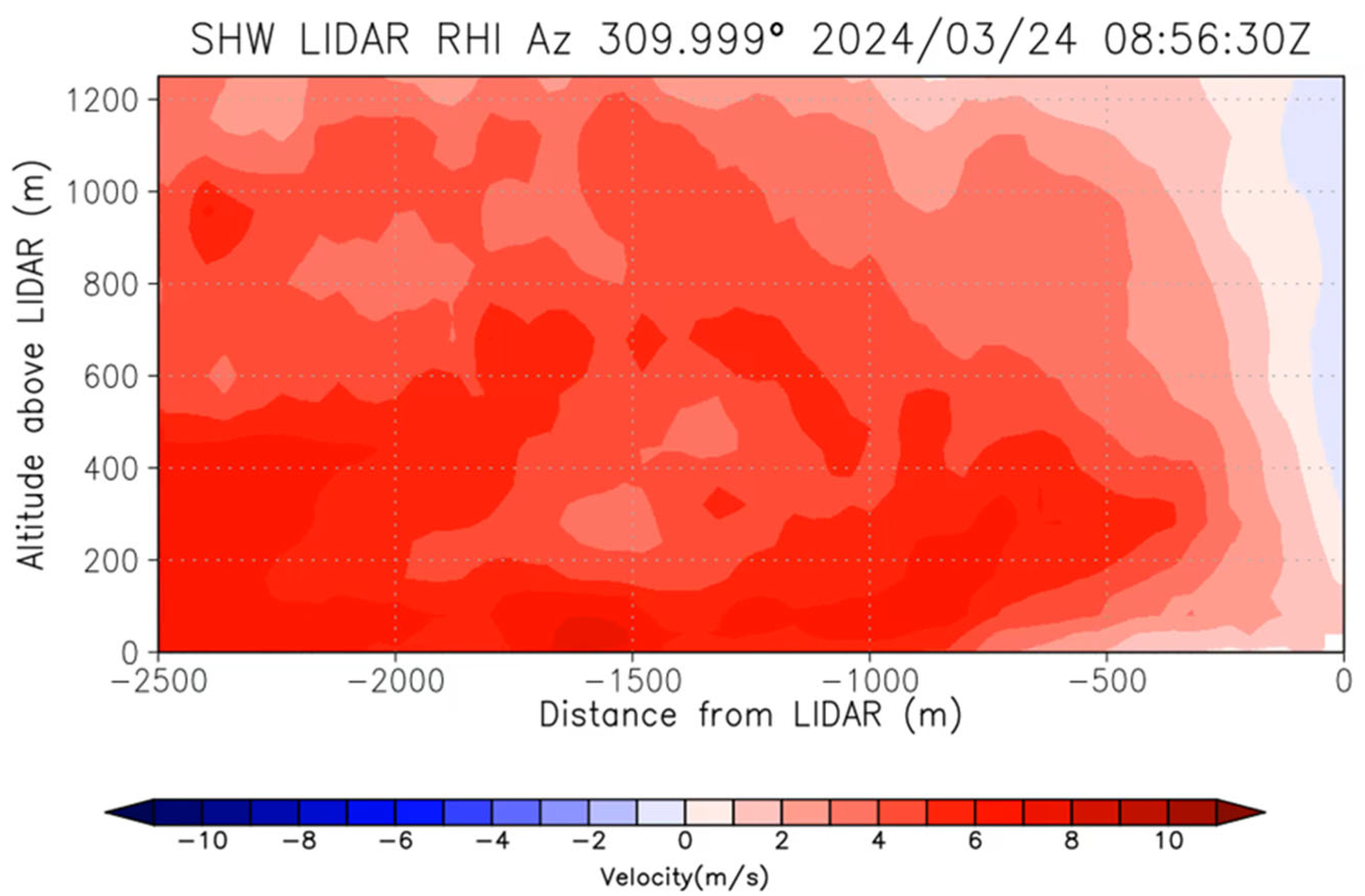
4. Hydraulic Jump-like Feature
5. Mountain Wave
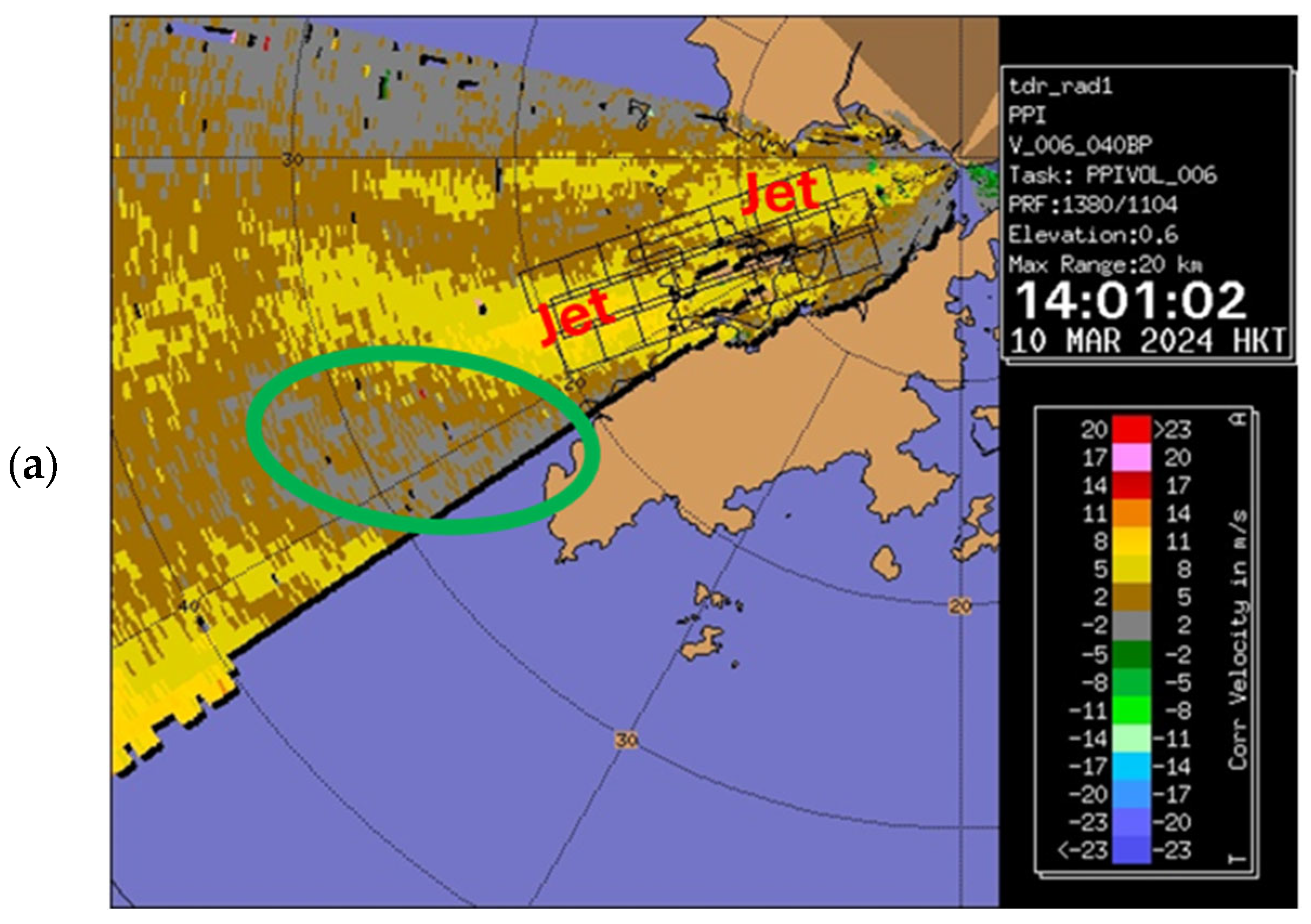
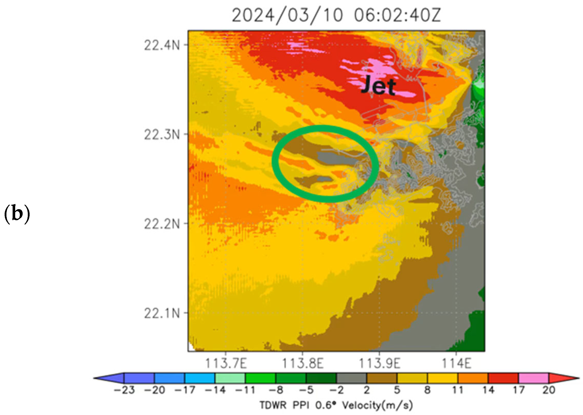
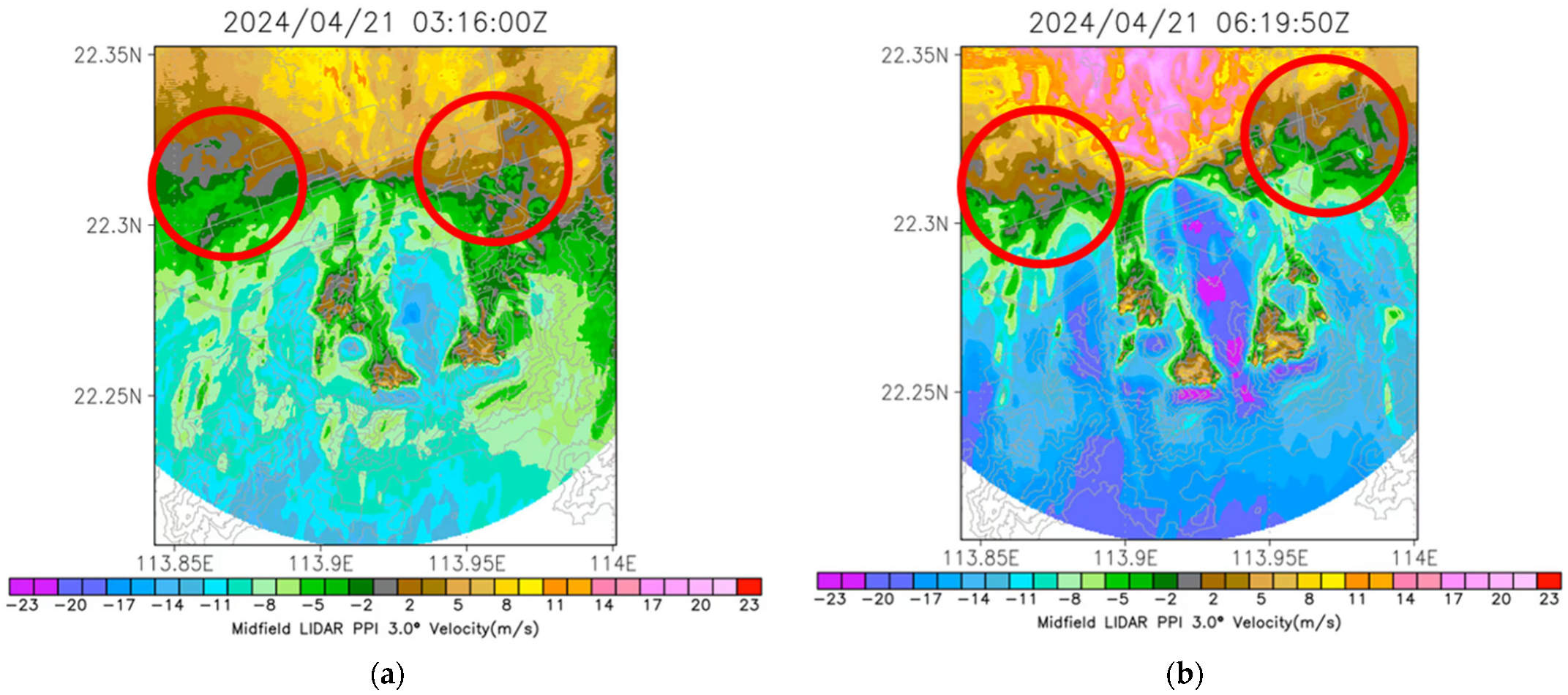
6. Vortex
7. Mountain Wake
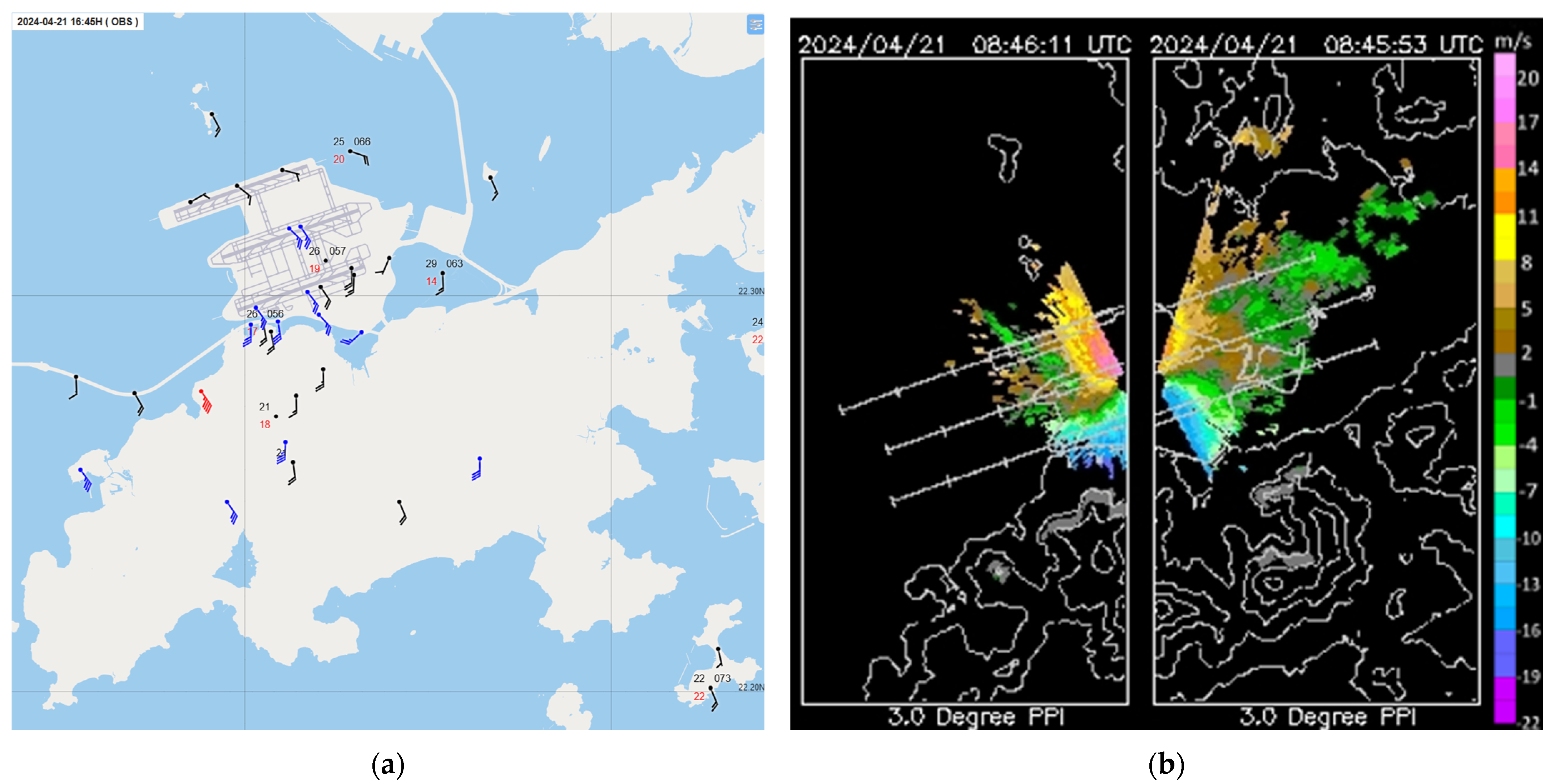
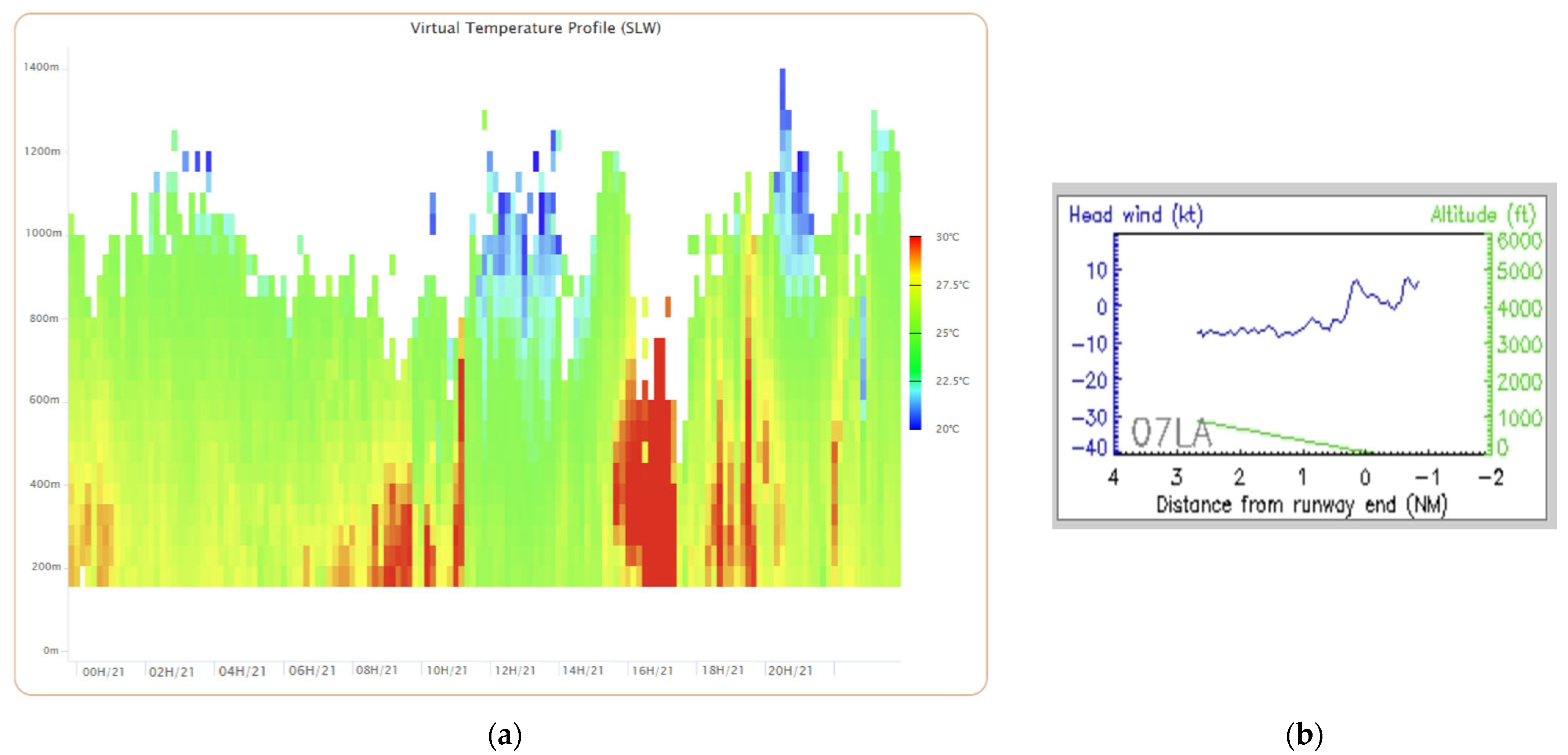
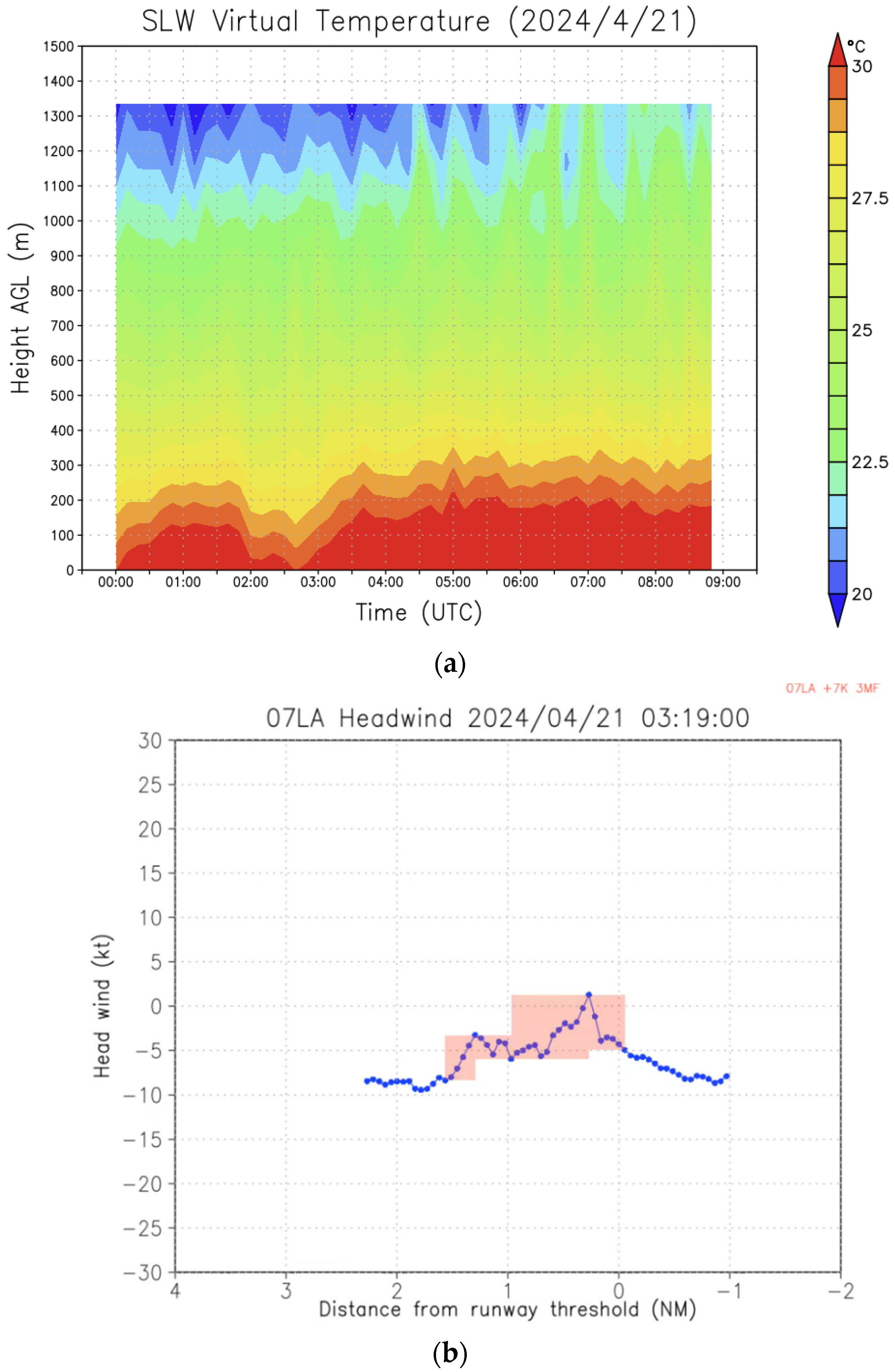
8. Reverse Flow Leading to Low-Level Windshear
9. Conclusions
Author Contributions
Funding
Institutional Review Board Statement
Informed Consent Statement
Data Availability Statement
Conflicts of Interest
References
- Shun, C.M.; Chan, P.W. Applications of an Infrared Doppler Lidar in Detection of Wind Shear. J. Atmos. Ocean. Technol. 2008, 25, 637–655. [Google Scholar] [CrossRef]
- Chan, P.W.; Cheung, P.; Lai, K.K. Observation and numerical simulation of terrain-induced airflow leading to low level windshear at the Hong Kong International Airport based on Range-Height-Indicator scans of a LIDAR. Meteorol. Z. 2024, 33, 255–262. [Google Scholar] [CrossRef]
- Guarino, M.; Teixeira, M.A.; Keller, T.L.; Sharman, R.D. Mountain-Wave Turbulence in the Presence of Directional Wind Shear over the Rocky Mountains. J. Atmos. Sci. 2018, 75, 1285–1305. [Google Scholar] [CrossRef]
- Jiang, Q.; Doyle, J.D. Gravity Wave Breaking over the Central Alps: Role of Complex Terrain. J. Atmos. Sci. 2004, 61, 2249–2266. [Google Scholar] [CrossRef]
- Clark, T.L.; Hall, W.D.; Kerr, R.M.; Middleton, D.; Radke, L.; Martin, F.; Neiman, P.J.; Levinson, D. Origins of aircraft-damaging clear-air turbulence during the 9 December 1992 Colorado downslope windstorm: Numerical simulations and comparison with observations. J. Atmos. Sci. 2000, 57, 1105–1131. [Google Scholar] [CrossRef]
- Smith, C.M.; Skyllingstad, E.D. Investigation of up-stream boundary layer influence on mountain wave breaking and lee wave rotors using a large-eddy simulation. J. Atmos. Sci. 2009, 66, 3147–3164. [Google Scholar] [CrossRef]
- Ehard, B.; Achtert, P.; Gumbel, J. Long-term lidar observations of wintertime gravity wave activity over northern Sweden. Ann. Geophys. 2014, 32, 1395–1405. [Google Scholar] [CrossRef]
- Fritts, D.C.; Smith, R.B.; Taylor, M.J.; Doyle, J.D.; Eckermann, S.D.; Dörnbrack, A.; Rapp, M.; Williams, B.P.; Pautet, P.; Bossert, K.; et al. The Deep Propagating Gravity Wave Experiment (DEEPWAVE): An airborne and ground-based exploration of gravity wave propagation and effects from their sources throughout the lower and middle atmosphere. Bull. Am. Meteorol. Soc. 2016, 97, 425–453. [Google Scholar] [CrossRef]
- Hertzog, A.; Souprayen, C.; Hauchecorne, A. Measurements of gravity wave activity in the lower stratosphere by Doppler lidar. J. Geophys. Res. 2001, 106, 7879–7890. [Google Scholar] [CrossRef]
- Kaifler, N.; Kaifler, B.; Ehard, B.; Gisinger, S.; Dörnbrack, A.; Rapp, M.; Kivi, R.; Kozlovsky, A.; Lester, M.; Liley, B. Observational indications of downward-propagating gravity waves in middle atmosphere lidar data. J. Atmos. Sol.-Terr. Phys. 2017, 162, 16–27. [Google Scholar] [CrossRef]
- Llamedo, P.; Salvador, J.; de la Torre, A.; Quiroga, J.; Alexander, P.; Hierro, R.; Schmidt, T.; Pazmiño, A.; Quel, E. 11 years of Rayleigh lidar observations of gravity wave activity above the southern tip of South America. J. Geophys. Res. Atmos. 2019, 124, 451–467. [Google Scholar] [CrossRef]
- Chan, P.W.; Lai, K.K.; Li, Q.S. High-resolution (40 m) simulation of a severe case of low-level windshear at the Hong Kong International Airport—Comparison with observations and skills in windshear alerting. Meteorol. Appl. 2021, 28, e2020. [Google Scholar] [CrossRef]
- Deardorff, J.W. Stratocumulus-capped mixed layers derived from a three-dimensional model. Bound. Layer Meteorol. 1980, 18, 495–527. [Google Scholar] [CrossRef]
- Gibbs, J.A.; Fedorovich, E. Sensitivity of turbulence statistics in the lower portion of a numerically simulated stable boundary layer to parameters of the Deardorff subgrid turbulence model. Q. J. R. Meteorol. Soc. 2016, 142, 2205–2213. [Google Scholar] [CrossRef]
- Chan, P.W.; Hon, K.K.; Li, Q.S. Mountain waves near Hong Kong International Airport: Observations and high-resolution model analysis. Weather 2022, 77, 20–26. [Google Scholar] [CrossRef]


Disclaimer/Publisher’s Note: The statements, opinions and data contained in all publications are solely those of the individual author(s) and contributor(s) and not of MDPI and/or the editor(s). MDPI and/or the editor(s) disclaim responsibility for any injury to people or property resulting from any ideas, methods, instructions or products referred to in the content. |
© 2025 by the authors. Licensee MDPI, Basel, Switzerland. This article is an open access article distributed under the terms and conditions of the Creative Commons Attribution (CC BY) license (https://creativecommons.org/licenses/by/4.0/).
Share and Cite
Chan, P.-W.; Cheung, P.; Lai, K.-K.; Xie, J.-L.; Leung, Y.-Y. Some Interesting Observations of Cross-Mountain East-to-Southeasterly Flow at Hong Kong International Airport and Their Numerical Simulations. Atmosphere 2025, 16, 810. https://doi.org/10.3390/atmos16070810
Chan P-W, Cheung P, Lai K-K, Xie J-L, Leung Y-Y. Some Interesting Observations of Cross-Mountain East-to-Southeasterly Flow at Hong Kong International Airport and Their Numerical Simulations. Atmosphere. 2025; 16(7):810. https://doi.org/10.3390/atmos16070810
Chicago/Turabian StyleChan, Pak-Wai, Ping Cheung, Kai-Kwong Lai, Jie-Lan Xie, and Yan-Yu Leung. 2025. "Some Interesting Observations of Cross-Mountain East-to-Southeasterly Flow at Hong Kong International Airport and Their Numerical Simulations" Atmosphere 16, no. 7: 810. https://doi.org/10.3390/atmos16070810
APA StyleChan, P.-W., Cheung, P., Lai, K.-K., Xie, J.-L., & Leung, Y.-Y. (2025). Some Interesting Observations of Cross-Mountain East-to-Southeasterly Flow at Hong Kong International Airport and Their Numerical Simulations. Atmosphere, 16(7), 810. https://doi.org/10.3390/atmos16070810