1. Introduction
One of the most important factors determining the energy and thermal regime of the snow cover is the radiation balance, a significant part of which is solar radiation. Solar energy reaches the snow surface in the form of direct and scattered radiation, but not all of it is absorbed—a significant proportion is reflected into the atmosphere [
1]. The degree of reflection of solar energy is characterized by such a parameter as the albedo of snow covers the ratio of reflected radiation to the total incident radiation [
2].
Albedo has a key impact on the energy balance of the earth’s surface, while solar radiation affects climate processes and environmental changes, such as global warming and melting snow covers. For example, in their work, researchers [
3] note the close relationship between surface albedo and climate feedback.
Albedo has a decisive influence on the processes of formation, transformation, and melting of snow, as well as on avalanche activity, especially in mountainous areas where the high spatial variability of the relief creates a complex radiation and thermal regime [
4,
5]. This indicator has a significant impact on the radiation balance of the underlying surface, the thermal regime of snow, its physico-mechanical properties and, as a result, on the formation of snow cover and avalanche danger.
The formation of avalanche risk in mountainous regions is determined by a complex interaction of climatic and geophysical factors, among which insolation and slope albedo play a key role. Studies show that solar radiation reaching the surface of the snow cover affects the rate of its transformation, which in turn changes the probability of avalanches [
6]. Snow cover albedo, which is the ratio of reflected to incident radiation, is also an important parameter regulating the thermal balance of slopes and snowmelt processes [
7].
Changes in albedo affect the rate of snowmelt, the amount of absorbed radiation, and the thermal dynamics of slopes. A small decrease in albedo can lead to a significant increase in absorbed solar radiation, which increases the rate of snowmelt, changing the timing and intensity of avalanche formation [
8]. High albedo values, on the contrary, contribute to a decrease in air temperature, which slows down the processes of snow cover transformation [
9,
10].
The albedo of the snow cover changes under the influence of the structure, moisture content, and pollution of the snow. For freshly fallen snow, the albedo is 0.80–0.95, meaning that only 5–20% of incoming radiation is absorbed. For dry drifted snow, the albedo decreases to 0.65–0.80. With increasing humidity and during the melting period, it decreases to 0.40–0.60, and for contaminated snow it can be 0.20 [
11]. In mountainous areas, where the slope and exposure determine the amount of incoming radiation, significant differences in the thermal regime of the snow cover are observed [
12].
Remote sensing allows for effective analysis of spatial and temporal changes in snow cover albedo, insolation, snow cover height, and temperature at the regional level [
13]. This is of particular importance in assessing avalanche hazard, since the insolation of slopes with varying exposure and steepness directly affects the intensity of snow transformation [
14].
It is well known that slope aspect significantly affects the level of insolation, which leads to significant differences in thermal processes and snowmelt intensity. Northern slopes, which receive less solar radiation, are characterized by higher snow cover stability, which increases avalanche risk under warming conditions [
15]. At the same time, southern slopes, having a lower albedo and greater insolation, contribute to accelerated snowmelt, which ultimately reduces the likelihood of avalanches [
4]. Remote-sensing products such as MODIS have proven invaluable for characterizing the spatiotemporal dynamics of snow cover, surface temperature, and albedo [
16,
17]. These diagnostics underpin the monitoring of snow conditions and the probabilistic forecasting of avalanche occurrence on slopes of differing aspects [
18]. Long-term records further show that climate-driven changes in snow cover albedo [
19] coincide with documented increases in avalanche frequency in several mountain regions [
20].
Recent studies emphasize that a comprehensive assessment of avalanche hazard must jointly examine the thermal state of the snowpack, terrain configuration (slope angle and aspect), and concurrent meteorological forcing [
21]. Modern forecasting frameworks, therefore, incorporate insolation and albedo as predictor variables to refine the diagnosis of hazard levels, which can be further used for practical measures for reducing avalanche risk (e.g., engineered barriers, controlled blasting, early-warning systems, etc.). Thus, the study of the interaction of insolation, albedo, and other climatic parameters with snow cover dynamics is an important area in avalanche hazard research. The use of remote sensing data and digital elevation models helps to improve avalanche risk forecasting, which is especially important in a changing climate.
The aim of this study is to quantify the influence of insolation and albedo on the formation of avalanche risk on slopes of different exposures. For this purpose, we plan to analyze the relationship between solar radiation, snow cover reflectivity, and avalanche frequency, taking into account the orientation of the slopes and their steepness. The results of this study can contribute to improving the methods for forecasting avalanche danger and developing effective measures to reduce risks in mountainous areas.
2. Materials and Methods
Research area. The East Kazakhstan region is located on the eastern border of Kazakhstan, at the junction of China, Mongolia, and Russia. Most of the territory is occupied by the Altai and Saur–Tarbagatai Mountains, as well as the Kalbinsky Range, with heights reaching 4000 m [
22].
The climate of the region is sharply continental. Winters are long, cold, and snowy, and summers are hot and dry, with dust storms. The average January temperature varies from −25 °C on the plains to −40 °C in closed high-mountain basins. In July, the temperature reaches +21 °C in the northwest and +32 °C in the southeast. At altitudes above 1 km, easterly winds prevail, with speeds of up to 20 m/s.
Snow cover is formed mainly in winter. In some years, the region experiences heavy snowfall, especially in mountainous areas such as Zyryanovsk, Katon-Karagay, Kokpekty, Urzhar districts, and the city of Ridder. The thickness of the snow cover can exceed the average long-term values by 2- to 3-fold. More than 60% of Kazakhstan’s forests are located in the East Kazakhstan region. The vegetation cover is characterized by pronounced vertical zonation. Forests include spruce, fir, larch, pine, birch, and aspen, and shrub vegetation is represented by thickets of acacia, honeysuckle, rose hips, and other plants [
23].
Initial data. This study was carried out using an integrated approach, including the processing of remote sensing data, climate datasets, and a digital elevation model. This approach provided a high degree of detail in the analysis and the ability to take into account spatiotemporal changes in parameters. All data processing was carried out on the Google Earth Engine (GEE) platform, which allowed for the efficient integration of data from various sources and the automation of their processing.
Data sources. The following satellite missions and climate models were used to estimate snow cover, albedo, surface temperature, air temperature, and precipitation:
Remote sensing data:
MOD10A1: daily snow cover data. The NDSI (Normalized Difference Snow Index) was used to determine the snow cover area and its seasonal changes. It is calculated based on the reflectivity in the visible (Green) and shortwave infrared (SWIR) ranges [
24]:
where
—reflectivity in the green part of the spectrum,
—reflectivity in the shortwave infrared part of the spectrum.
NDSI values above 0.4 indicate the presence of snow. To assess seasonal changes in snow cover, the average value of the index for the winter months was calculated:
where M = 3—number of winter months (December, January, February).
MCD43A3: shortwave surface albedo data (BSA—direct solar radiation albedo, WSA—diffuse radiation albedo). These data were used to analyze spatiotemporal variations in snow cover reflectivity. The total surface albedo was calculated as the arithmetic mean [
25]:
The average albedo values for the winter period were calculated similarly:
where
—is the albedo value for month j,
= 3—is the number of winter months.
MOD11A1: daytime and nighttime land surface temperatures (LST_Day_1 km and LST_Night_1 km), which allowed us to estimate the thermal regime of the snow cover. The land surface temperature (LST) was calculated for daytime (T
day) and nighttime (T
night) regimes [
26]. Transformation of values from the original MODIS data:
where LST is the original temperature value from the MOD11A1 data, and T is the temperature in degrees Celsius.
The average temperature for the day was calculated as follows:
CHIRPS (Climate Hazards Group InfraRed Precipitation): daily precipitation data with a spatial resolution of 0.05° (~5 km), used to analyze the volume of winter precipitation and its impact on snow cover [
27]. The total winter precipitation was calculated as follows:
where P
d—precipitation for day d, D—total number of days in winter.
Mean precipitation values (
) were calculated for the region of interest (ROI):
where P
i—precipitation in the i-th pixel, N—number of pixels in the analyzed area.
GPM (Global Precipitation Measurement): high-resolution (0.1°) data from the IMERG_V06 collection [
28], used to estimate precipitation intensity during winter periods. Average daily intensity (R
day) was calculated as follows:
where R
h—precipitation intensity per hour h, H = 24—number of hours in a day.
Total intensity for winter (R
winter):
where D—number of days in winter.
ERA5-Land (European Centre for Medium-Range Weather Forecasts): air temperature at 2 m above ground (temperature_2 m) [
29]. Hourly data (Th) were aggregated to calculate winter averages:
where H = 24—number of hours in a day.
Average temperatures for winter (T
winter):
Digital elevation model: SRTM (Shuttle Radar Topography Mission): Data with a spatial resolution of 30 m were used to calculate the slope (S), aspect (A), and height of the slopes above sea level. These parameters became the basis for assessing the thermal regime of the slopes and incoming radiation.
This study additionally took into account slope and aspect of the slopes, which allowed for detailed spatial differences in the distribution of factors influencing avalanche risk. These parameters were calculated based on a digital elevation model (SRTM) using terrain analysis tools available on Google Earth Engine.
Calculation of slope and aspect of slopes. Based on the DEM data, slope and aspect were calculated for each pixel of the region of interest (ROI). Slope is the angle of inclination of the surface relative to the horizontal plane. It was calculated using the standard function ee.Terrain.slope provided on Google Earth Engine [
30,
31]:
where
is the change in height between adjacent pixels, while
and
are the horizontal distances between pixels.
The calculated slope was used to identify slopes that fell within the avalanche risk range (30° S 45°).
Aspect is the direction of the surface tilt relative to north. It was calculated using the ee.Terrain.aspect function [
32]:
where
and
—horizontal changes in coordinates.
The result is expressed in degrees (0°—north, 90°—east, 180°—south, 270°—west).
The slope exposure was divided into four main categories:
Northern (0°–90°);
Eastern (90°–180°);
Southern (180°–270°);
Western (270°–360°).
This study covers winter periods (December, January, February) for 24 years—from 2000 to 2024. Such a long time range allows us to analyze both seasonal and long-term trends in changes in snow cover, albedo, and other factors affecting avalanche risk.
Spatial and seasonal aggregation. To analyze climate and snow characteristics at the regional level, spatial aggregation of parameters (snow cover, albedo, temperature, and precipitation) was performed. Spatial averaging was performed using the reduceRegion function in GEE, and the average values of the parameters were calculated using the following formula:
where
—average value of the parameter,
—parameter value for the i-th pixel, N—total number of pixels in the analyzed region.
To eliminate the influence of interseasonal variations, the data were aggregated for winter periods (December, January, February). Average seasonal values (
) were calculated using the formula
where
—average value of the parameter for month j, M
= 3—number of months in the winter period.
Calculation of radiation characteristics. Based on the slope and slope aspect data, radiation calculations were performed. Insolation (I) was calculated taking into account the slope angles (S) and slope azimuth (A), as well as the position of the sun. The level of incoming radiation was determined by the following formula [
33,
34]:
where I—insolation (W/m
2),
—solar constant (1361 W/m
2), Z—zenith angle of the sun’s rays, A—slope exposure azimuth, A
s—azimuth of the sun, S—slope angle.
The calculated insolation was used to estimate differences in incoming radiation between slope aspects.
Avalanche risk mapping. Avalanche risk (R) was modeled as a function of several factors: slope (S), insolation (I), snow cover (H), temperature (T), and albedo (α). The general formula for risk assessment was as follows [
33,
34,
35]:
where
—slope (30°
S
45°), Exposition—slope exposure, I—insolation (I > 0.5), H—snow cover (H > 50%), T—temperature (T > −5 °C),
—albedo (α < 0.5).
The probability of avalanche risk was determined by a binary function:
Handling of abnormal data. Special attention was paid to handling abnormal values. To prevent distortions in the analysis, empty pixels were replaced with the value 000, the size of data collections was checked before performing operations, and outliers were identified and excluded using the interquartile range (IQR) method—values lying outside 1.5 times the IQR from the first and third quartiles were considered outliers. This ensured the integrity and reliability of the dataset used in subsequent calculations [
36].
To analyze climate change in the region, data from seven weather stations operated by the national hydrometeorological service of Kazakhstan, “Kazhydromet”, were utilized. These stations are situated in close proximity to the avalanche-prone areas under study. All data were available in digital format for the period from 2001 through the end of the winter season on 31 March 2024. This time span was sufficient to assess climate change in the region.
3. Results and Discussion
The analysis of MODIS (MCD43A3) data showed that the albedo of the snow cover exhibits pronounced spatial and temporal variations due to changes in temperature, humidity, and slope exposure. For freshly fallen snow, the albedo is 0.80–0.95, but with an increase in temperature and snow pollution, it decreases to 0.20–0.40, especially on the southern and eastern slopes with high insolation (
Figure 1).
The figure shows the long-term spatial and temporal distribution of snow cover albedo in the East Kazakhstan region for the period 2000–2024. Each map displays albedo values for a specific year, which allows us to analyze the dynamics of changes in surface reflectivity. Albedo values range from 0 (red), indicating minimal reflectivity, to 1 (blue), characteristic of fresh and light snow cover that reflects most of the solar radiation.
Starting in 2014, a significant increase in albedo has been observed across much of the region, with predominant blue and cyan shades indicating extensive and possibly fresher snow cover. This pattern continues through 2024, suggesting either increased snow accumulation, changes in snow properties, or variations in image acquisition timing and atmospheric conditions affecting satellite observations.
In recent years (2015–2024), a decrease in albedo was observed, especially in low-mountain and mid-mountain areas. This trend may be related to climate change, rising temperatures, and snow cover pollution. The northern slopes continue to demonstrate consistently high albedo values, which is due to lower insolation and long-term preservation of snow cover, in contrast to the southern and eastern slopes, where albedo decreases due to more accelerated snowmelt.
Regression analysis of the dependence of albedo (α) on temperature (T), snow cover (H), and insolation (I) allowed us to quantify these relationships. The formula had the following form:
where β
0—free member; β
1, β
2, β
3, β
4—regression coefficients; ε—residual component.
The results showed that an increase in temperature (T) has a negative effect on albedo (β1 = −0.016, < 0.01), while an increase in snow cover (H) promotes its growth (β2 = 0.045, < 0.01). This indicates the importance of albedo as a factor that slows down snowmelt processes. An increase in insolation (I) also negatively affects albedo (β3 = −0.010, < 0.01), indicating that stronger solar radiation reduces surface reflectivity. However, regression analysis of the dependence of avalanche risk on albedo (α) showed that its role in avalanche formation is limited. The influence of albedo is manifested through indirect connections: it affects the preservation of snow cover (r = 0.16) and is partially associated with the temperature regime (r = −0.16). Nevertheless, albedo is not the main factor in avalanche formation.
Additionally, the analysis showed that high insolation (β4 = 0.024, < 0.01) amplifies the effect of temperature on avalanche risk. Specifically, the impact of temperature is stronger under higher solar radiation, all else being equal.
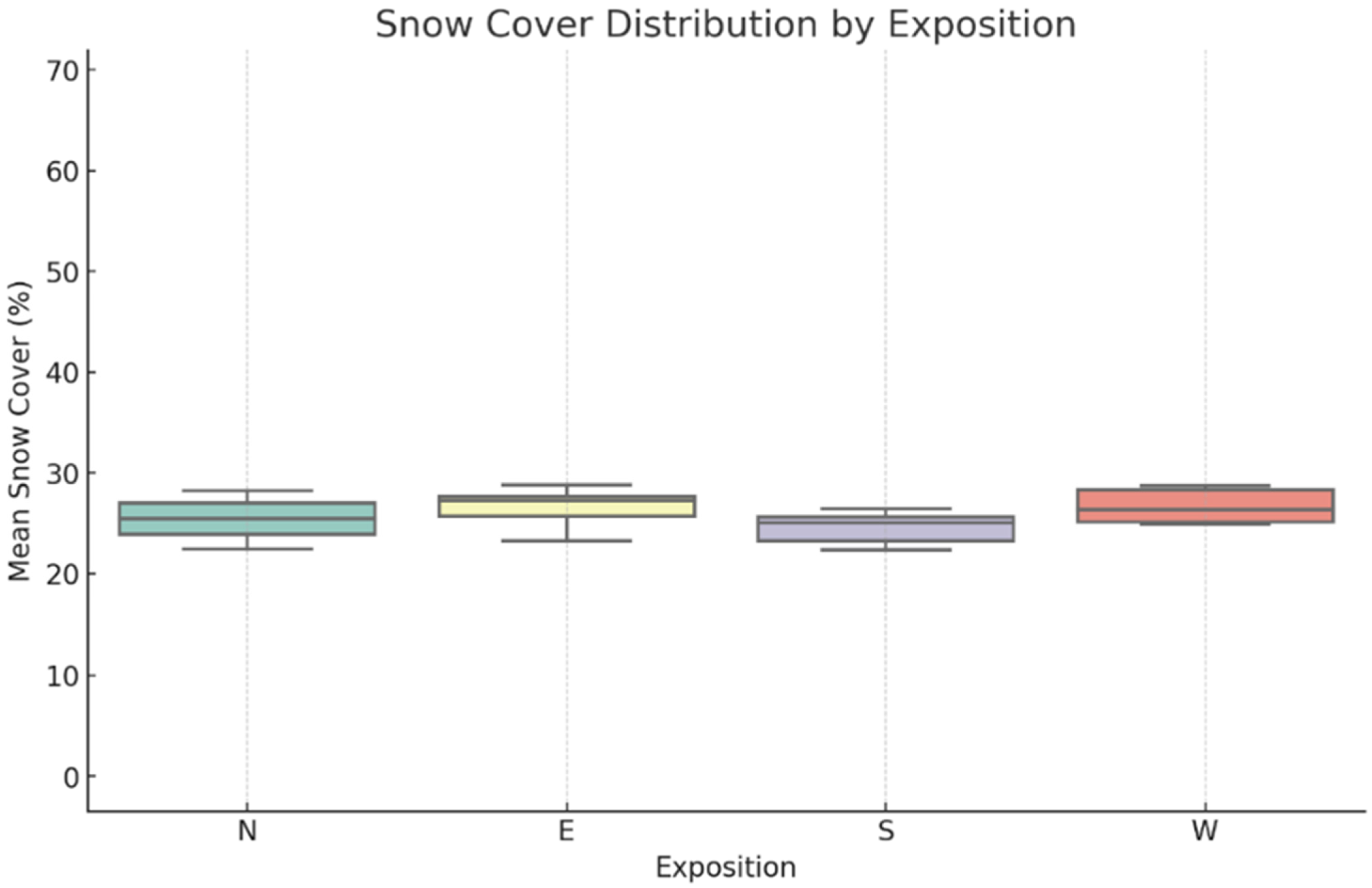
Figure 2 shows the dependence of snow albedo on the surface slope for different winter months (November–March). The diagrams show the distribution of slope areas grouped by slope categories (0–20°, 20–30°, 30–45°, 45–60°, 60–80°) and albedo ranges (0–20%, 20–40%, 40–60%, 60–80%, 80–100%). The highest albedo values are characteristic of gentle slopes (0–20°), while with increasing slope, a decrease in albedo is observed, especially in the ranges of 20–40% and below. The changes presented for each month reflect the seasonal features of the snow cover and its reflectivity.
Snow cover and its relationship with slope aspect. The MOD10A1 data revealed significant spatial differences in snow cover stability (H) depending on slope aspect (
Figure 3). The northern and western slopes are characterized by higher snow cover (30–50%) due to low insolation (
Figure 4) and low temperatures. On the southern slopes, snow cover is less stable (20–30%) due to more intense solar radiation.
For quantitative analysis, a linear regression model was used:
where H—snow cover; I—insolation; T—temperature; E—exposure coded as a categorical variable;
—regression coefficients.
The results showed that insolation (I) and temperature (T) have a negative effect on snow cover (). On the contrary, northern exposure is positively correlated with snow depth ().
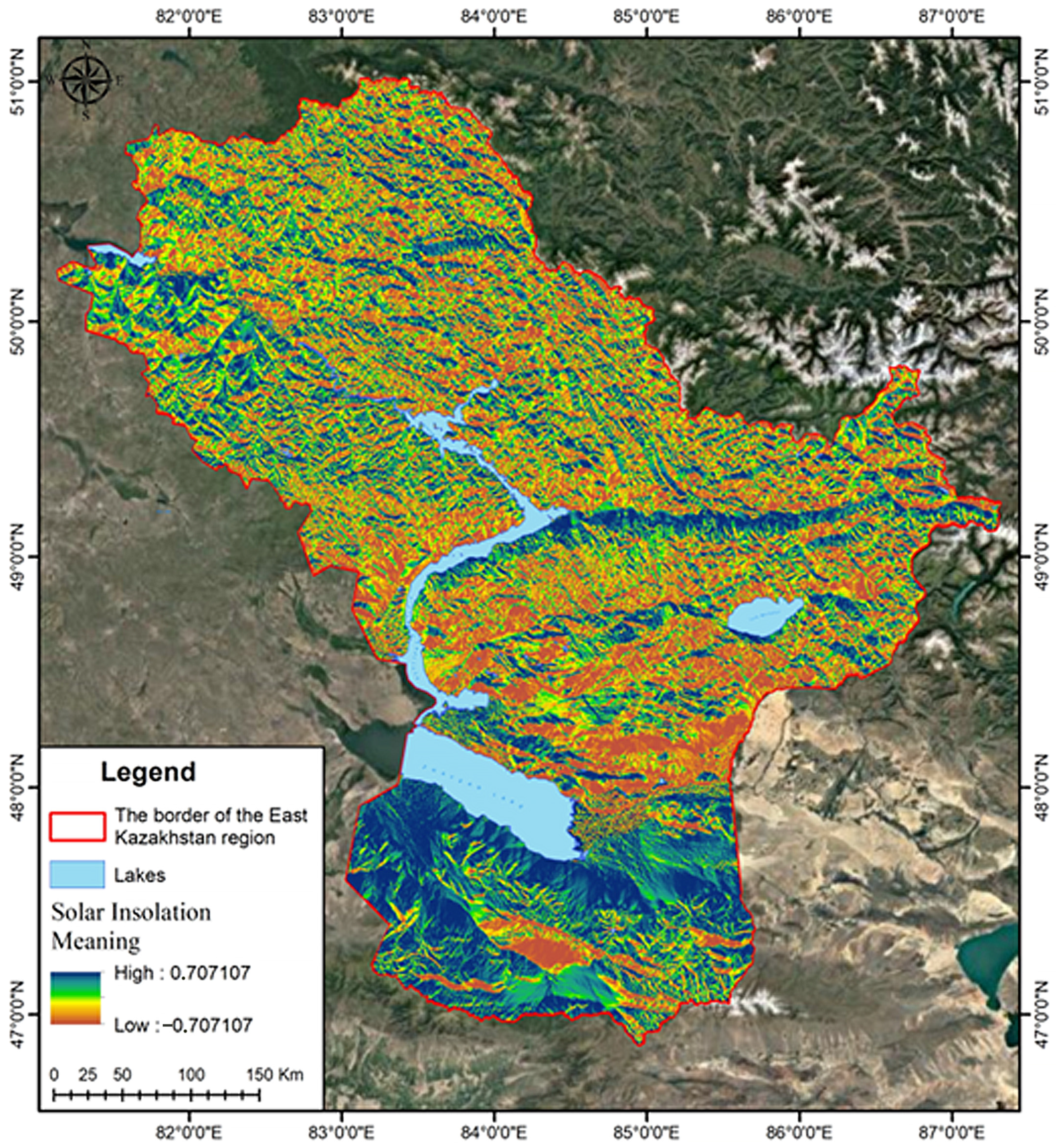
Insolation and avalanche risk. The data from the insolation analysis, calculated on the basis of the digital elevation model (SRTM) (
Figure 4), showed that the southern and eastern slopes receive the maximum amount of solar radiation. This leads to a decrease in snow cover and a decrease in avalanche risk. On the contrary, the northern and western slopes receive less solar energy, which helps to preserve snow cover and increases the probability of avalanche formation (
Figure 5).
Logistic regression was used to visualize the probability of avalanche risk (R):
where P(R = 1)—probability of avalanche; I, S, T, H, α—insolation, slope, temperature, snow cover and albedo;
—regression coefficients.
The results showed that insolation (I) and slope (S) have a positive effect on avalanche risk (
), while albedo (α) and temperature (T) reduce the risk (
). Steeper terrain mechanically favors avalanche release because the downslope component of the snowpack’s weight increases with slope angle and more readily exceeds the shear strength of weak layers; field data show that starting zones concentrate almost exclusively on slopes ≥30°, with release probability rising up to about 45° [
37,
38]. Hence, the positive coefficient of “slope” in our logistic model reflects this well-documented physical control rather than a purely statistical artifact.
Temperature regime. The analysis of the MOD11A1 and ERA5-Land datasets confirmed significant differences in air and surface temperatures depending on slope aspect. The northern slopes, with low insolation, exhibit winter temperatures of up to −15 °C, while on the southern slopes, the temperature can reach −5 °C.
The regression model describing the dependence of temperature (T) on aspect (E) and altitude (h) took the following form:
where T—temperature; h—height; E—exposure;
—regression coefficients.
The results showed that the temperature decreases with increasing altitude ( and is lower on the northern slopes (. The high snow cover values on the northern slopes at low temperatures create favorable conditions for avalanche formation. In addition, the snow depth (H) and temperature regime (T) are the main factors determining the avalanche risk. The regression model showed a strong positive correlation between snow cover and avalanche risk (r = 0.87). High snow cover values on the northern slopes at low temperatures create favorable conditions for avalanche formation.
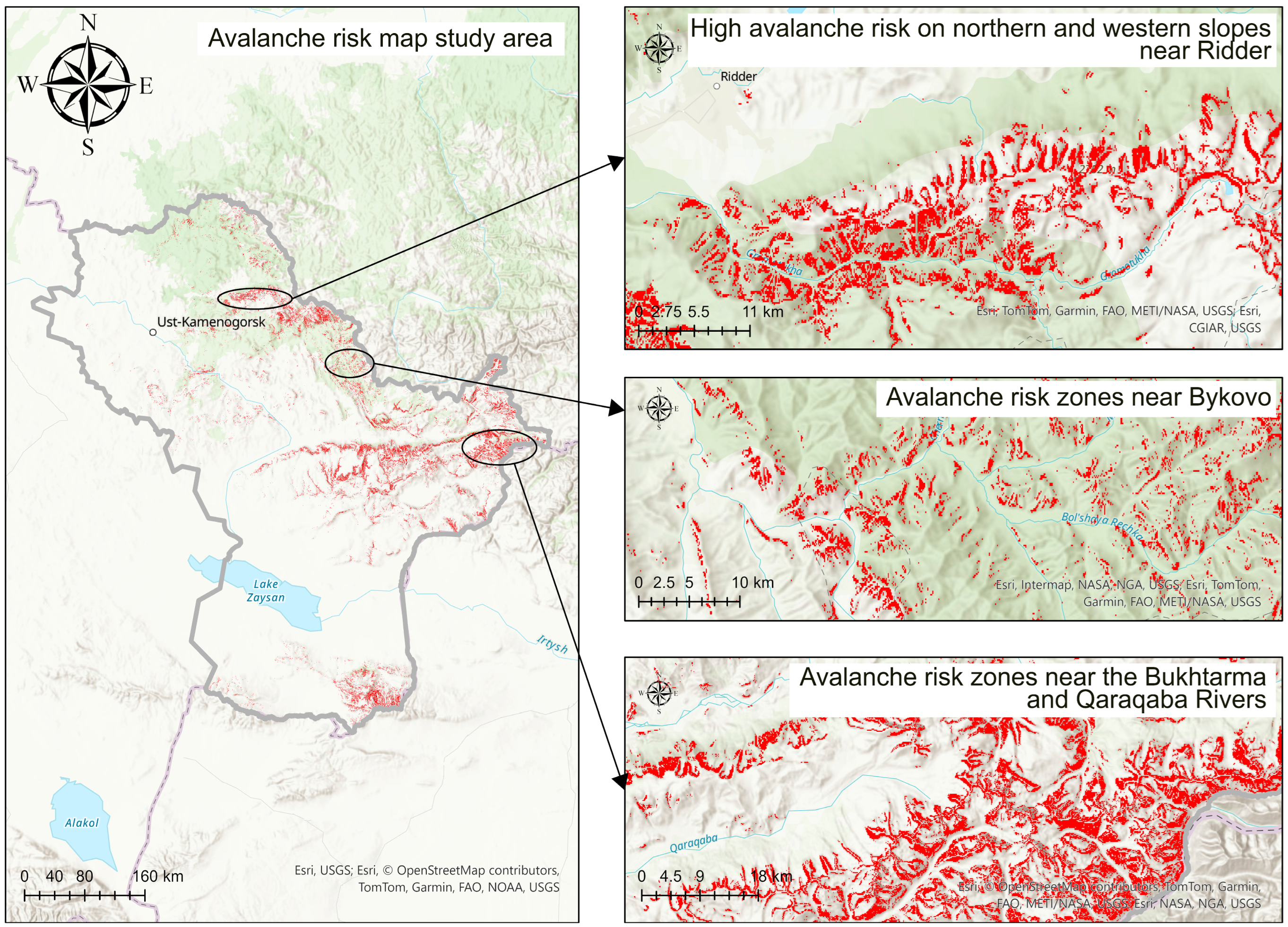
Avalanche risk and correlation analysis. The avalanche risk map demonstrated high forecasting accuracy. The northern and western slopes, with low temperatures and stable snow cover, remain the most avalanche-prone, despite the high albedo. The southern and eastern slopes, on the contrary, demonstrate a lower avalanche risk due to intense insolation and snowmelt (
Figure 5).
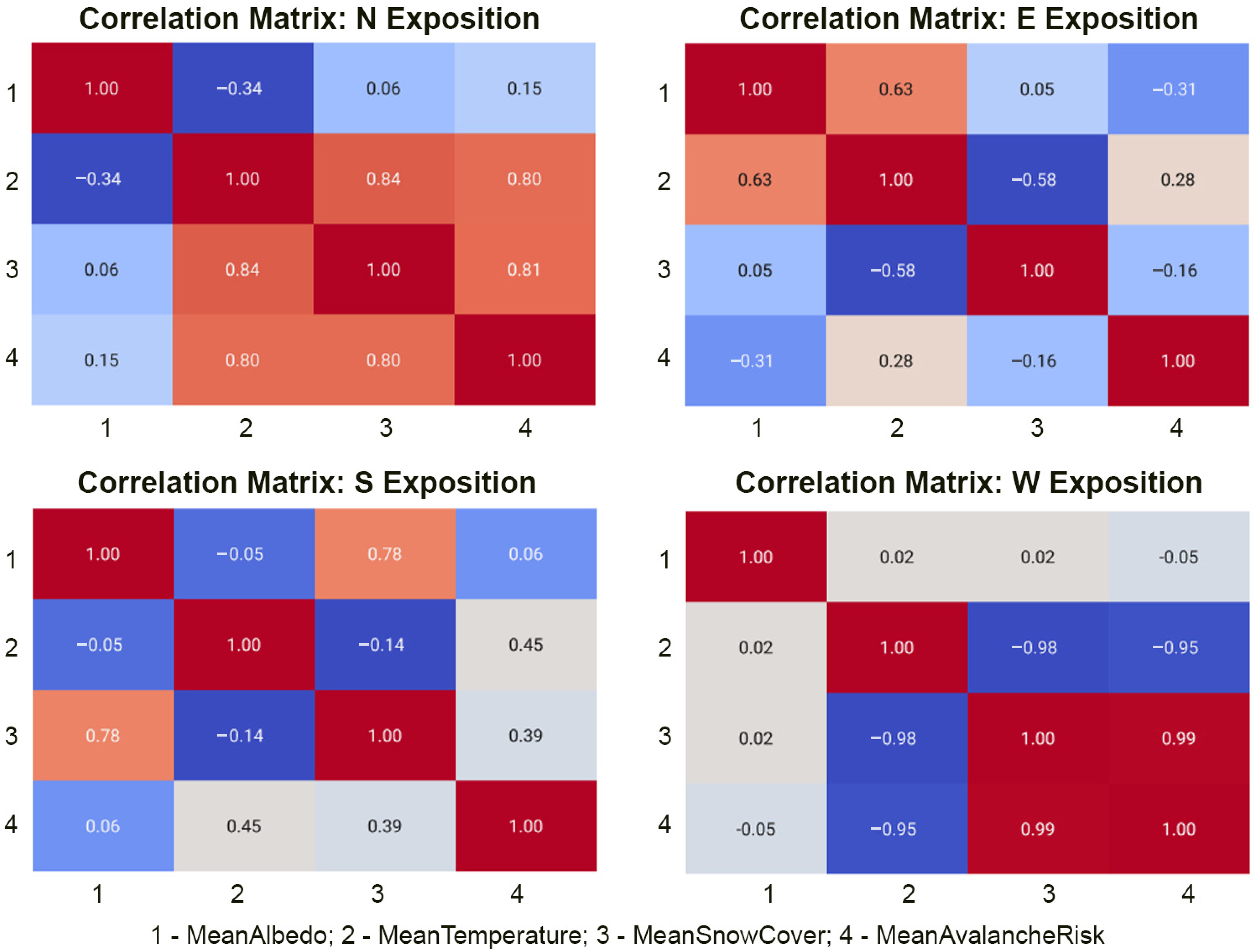
Correlation matrices showed the following (
Figure 6):
Avalanche risk on the northern slopes correlates most strongly with snow depth (r = 0.81).
On the southern slopes, avalanche risk reduction is more dependent on temperature (r = −0.45).
Albedo has the greatest influence on the northern and western slopes (r = 0.15).
Logistic regression of avalanche probability confirmed that the main determinants of avalanche risk are snow cover (H), temperature (T), and slope (S). Albedo (α) and insolation (I) play a supporting role.
To assess the accuracy of the avalanche risk map, the predicted data (avalanche risk map) were compared with the actual avalanche-prone areas provided as vector data. The analysis was based on two key metrics: overall accuracy and Kappa coefficient, which are standard metrics for assessing the fit of a model to real data. The results of the analysis show that the overall accuracy of the model is 86%, indicating a high degree of coincidence between the predicted avalanche-prone areas and the actual data. The Kappa coefficient is 0.72, indicating “substantial agreement” between the model predictions and observations, exceeding chance. The high accuracy of the model is due to the use of key factors such as slope, insolation, snow cover, temperature, and albedo.
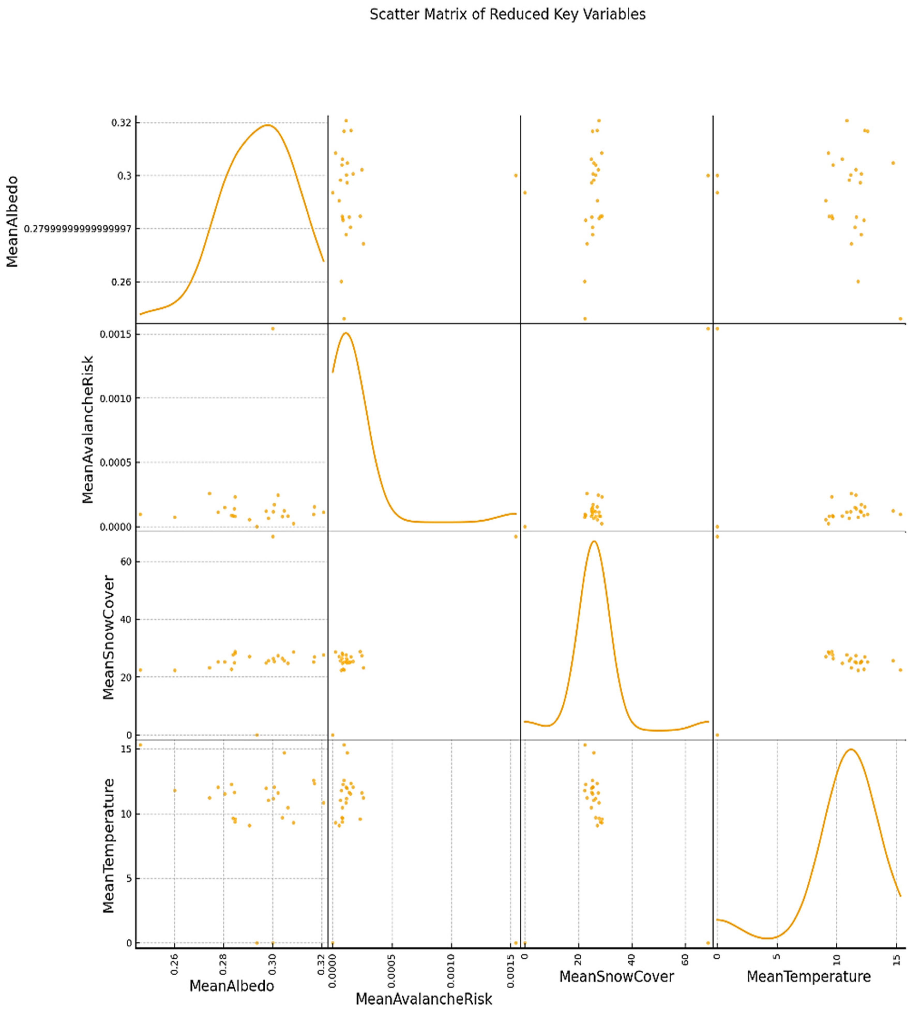
The scatterplot matrix plot (
Figure 7) illustrates the relationships between the key variables: albedo (MeanAlbedo), avalanche risk (MeanAvalancheRisk), snow cover (MeanSnowCover), and temperature (MeanTemperature). The data mentioned earlier were used for the analysis, including correlation dependencies, spatial variations, and regression analysis results.
The scatterplot diagram shows that there is virtually no direct relationship between albedo and avalanche risk. The distribution of points is chaotic, which confirms the low correlation between these variables (r = 0.07). This result is consistent with the conclusion from the previous analysis: albedo has only an indirect effect on avalanche risk, through its relationship with snow cover and temperature.
The diagram shows a clear positive relationship between snow depth and avalanche risk. The higher the snow cover (MeanSnowCover), the higher the probability of avalanche formation. The correlation between these parameters (r = 0.87) confirms that the snow depth is a key factor in avalanche risk. On the northern slopes, with higher snow cover, the avalanche risk increases, which is consistent with previously constructed regression models.
The scatterplot shows a negative relationship between temperature (MeanTemperature) and avalanche risk. At lower temperatures, the avalanche risk is significantly higher. The correlation between these parameters is (r = −0.54), which is explained by the long-term preservation of snow cover at low temperatures, especially on the northern slopes. On the southern slopes, where the temperature is higher, the avalanche risk is reduced.
There is a weak positive relationship between albedo (MeanAlbedo) and snow cover (MeanSnowCover), which is confirmed by the correlation value (r = 0.16). This indicates that high albedo helps slow down the melting of the snow cover, which indirectly affects its stability. However, as the data show, this effect is weaker compared to temperature.
The diagram illustrates a clear negative relationship between temperature (MeanTemperature) and snow cover (MeanSnowCover). At lower temperatures, snow cover is better preserved (r = −0.25). This is due to the slower rate of snowmelt at negative temperatures.
The scatter matrix analysis showed that snow depth and temperature are the main determinants of avalanche risk. High snow cover values increase the probability of avalanches, especially on the northern slopes, where snow remains longer due to low temperatures and lack of solar insolation. Temperature, in turn, has a decisive influence on avalanche formation: at low temperatures, the stability of the snow cover is maintained, which increases the probability of avalanches, especially on shaded slopes.
Albedo and insolation play a supporting role, affecting the durability and stability of the snow cover. Albedo is related to snow cover (r = 0.16, since high albedo helps reduce the absorption of solar radiation and slows down the melting processes of snow. However, its direct influence on avalanche risk is minimal. Insolation also affects snow cover, but its contribution is secondary compared to key factors such as temperature and snow depth.
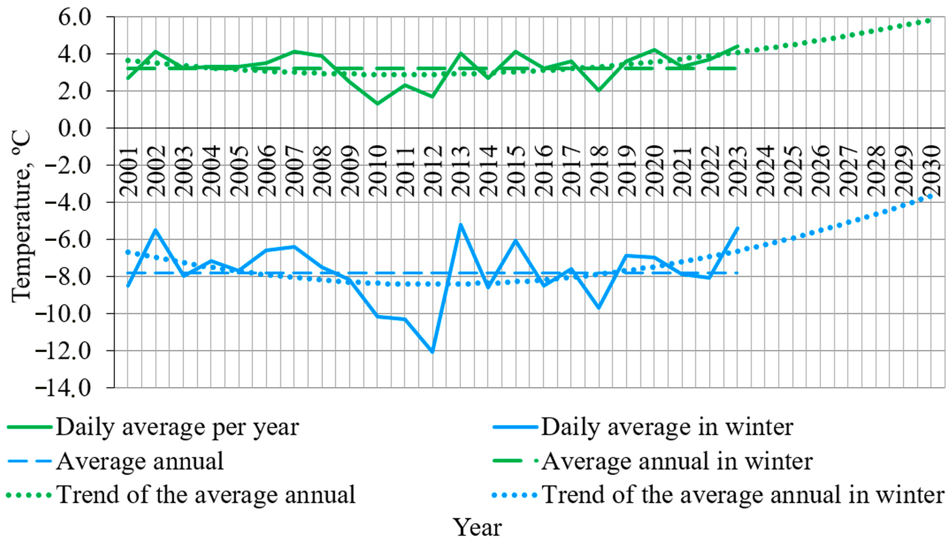
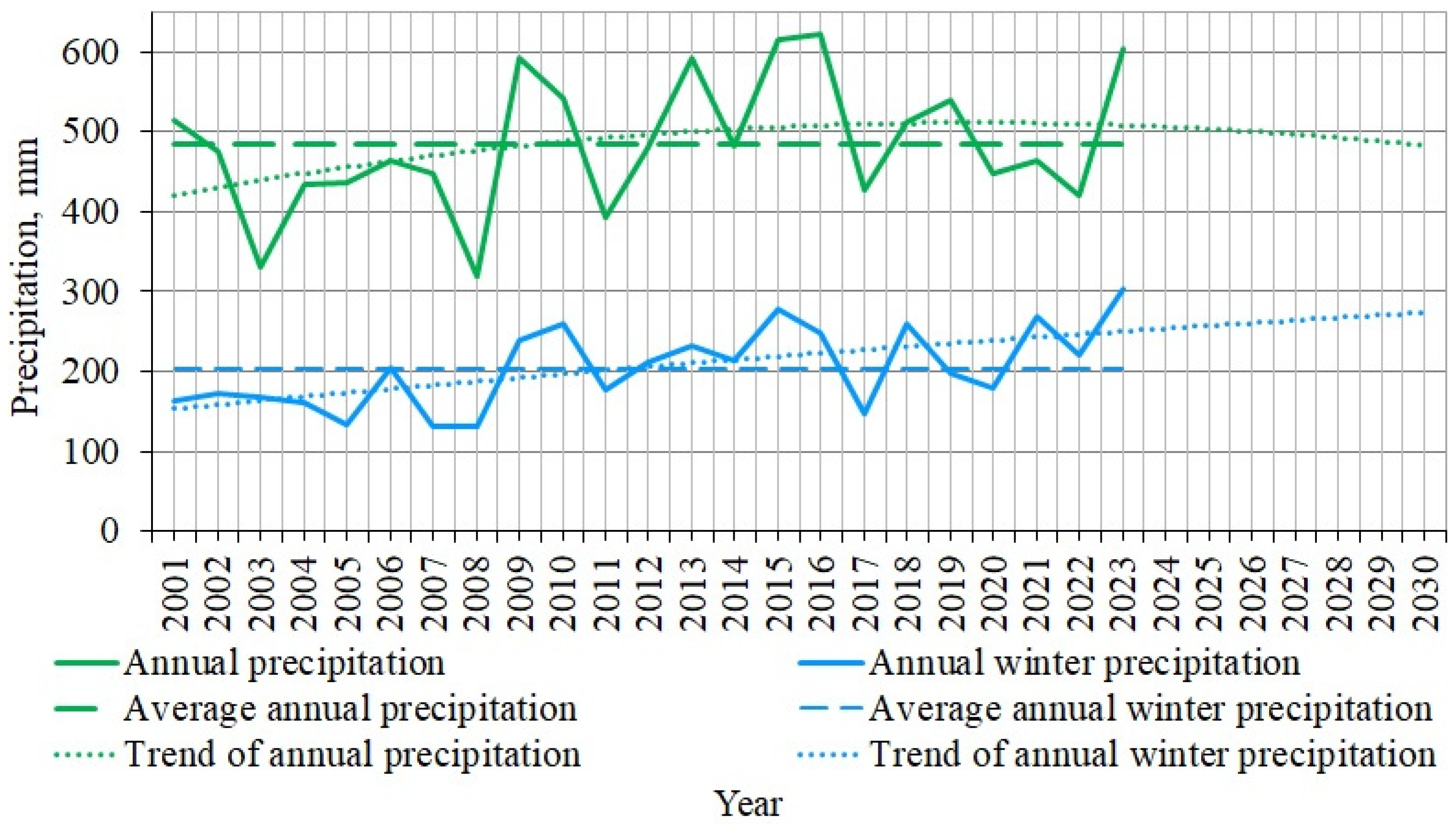
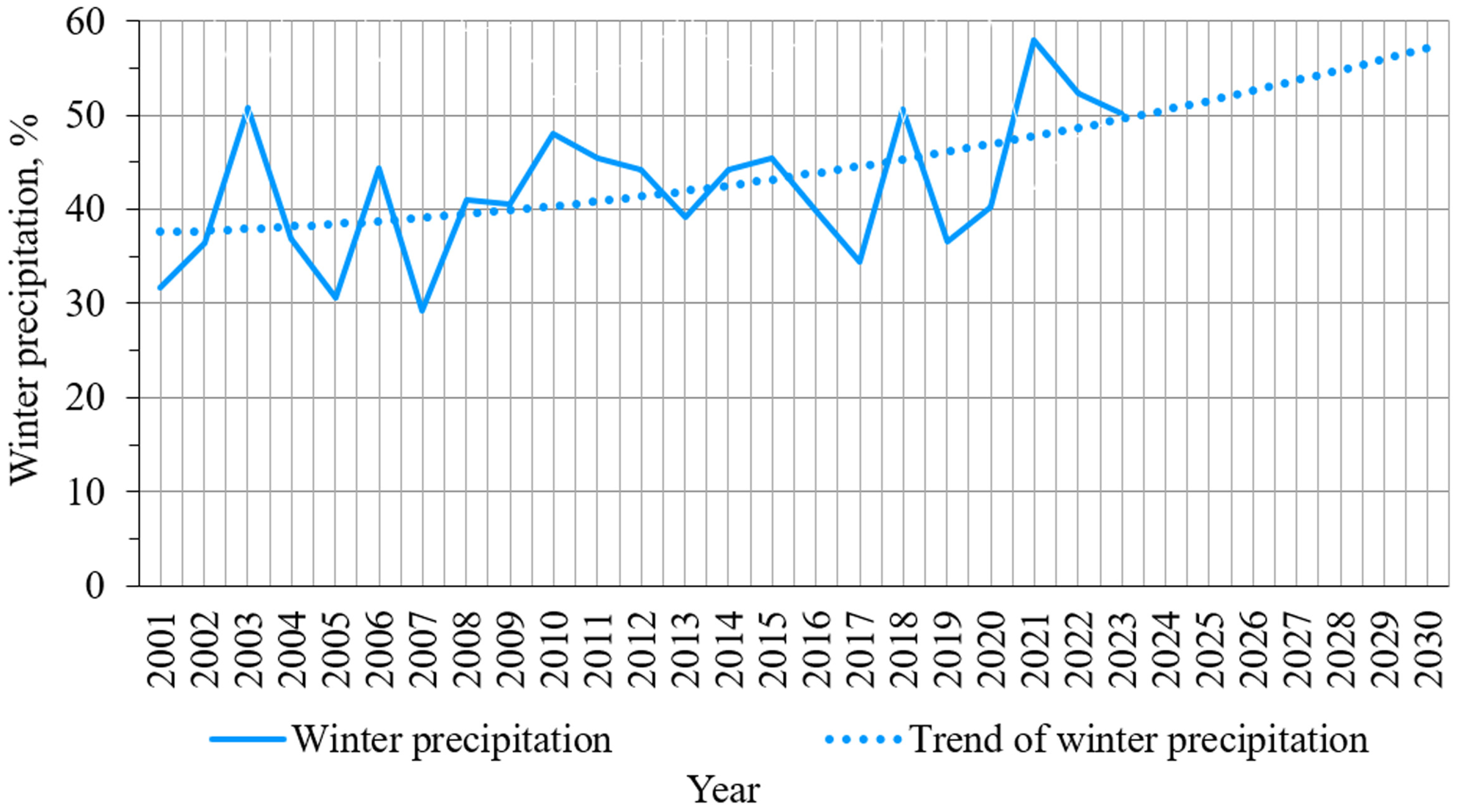
Let us consider the weather data for the study area. The analysis revealed climatic changes that have occurred in the region over an extended period. The results of the analysis are presented in
Figure 8,
Figure 9,
Figure 10,
Figure 11 and
Figure 12. The trend lines indicate a near-term forecast of further climatic changes. Trend lines were constructed based on second-degree polynomial dependencies.
The presented data demonstrate that temperature trends align with global changes and indicate a gradual increase in air temperature in the region (
Figure 8).
The precipitation data in
Figure 9 indicate a slight increase in the average annual precipitation; however, projections suggest a future decrease. In contrast, winter precipitation is expected to increase, with a shift in peak precipitation from summer to winter, as also shown in
Figure 10.
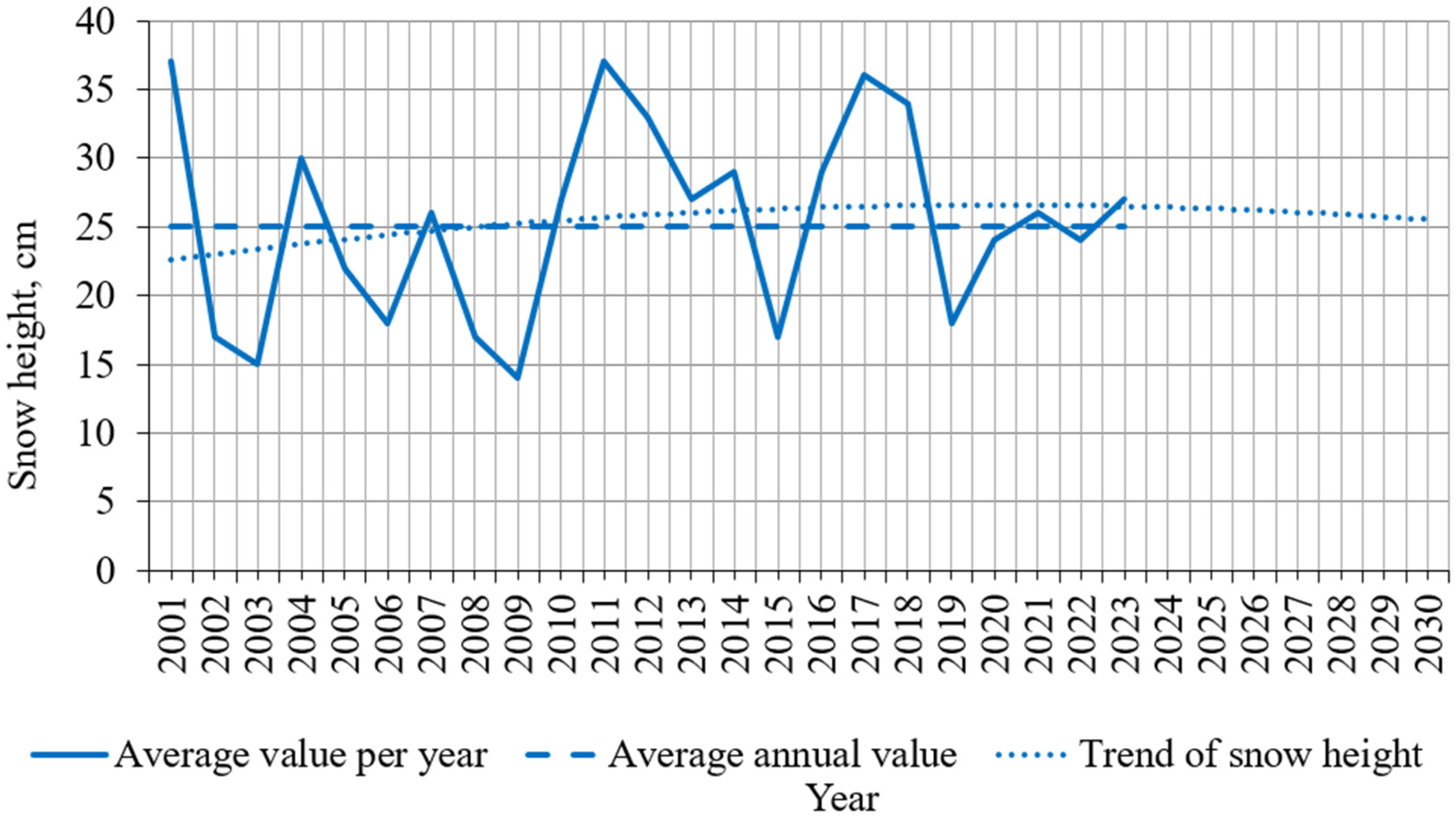
The average annual snow cover height is shown in
Figure 11. It has exceeded the annual average since 2009, but the general trend indicates a decrease in snow height.
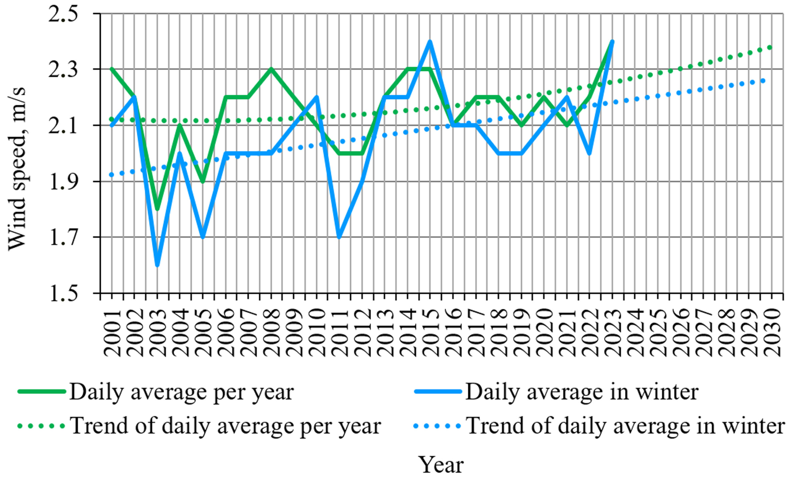
An important factor influencing avalanches is the wind regime in the region. Wind speed data for the study area indicate a tendency to increase (
Figure 12). This trend applies both to the average annual wind speeds and to those observed during winter. An increase in wind speed will lead to greater local variability in snow cover on slopes and, consequently, to a higher risk of avalanches in the region. As can be seen from the graphs depicting changes in weather data, the microclimate of the region is undergoing transformation, and these trends are likely to continue in the coming years. The climate is expected to become more humid and warmer, which will inevitably affect the avalanche conditions in the area.
The main factors of avalanche risk are related to the temperature regime and snow depth, while albedo and insolation play a supporting role, affecting the spatiotemporal changes in snow cover.
The obtained results show that snow depth and temperature are key factors in avalanche formation, while albedo and insolation have only an indirect effect on these processes. The northern and western slopes, with low insolation and negative temperatures, remain the most avalanche-hazardous. The southern and eastern slopes, on the contrary, are characterized by less snow cover and, accordingly, a lower risk of avalanches.
Remote sensing and climate model data made it possible to create a multi-parameter avalanche risk map that takes into account both the main factors (such as snow cover and temperature) and auxiliary ones (insolation, albedo). These results have practical significance for avalanche safety management, improving the accuracy of forecasts and developing adaptation strategies to climate change in mountainous areas.
4. Conclusions
This study examined the role of albedo, insolation, snow depth, slope, temperature, and slope aspect in the formation of avalanche risk. Spatiotemporal data obtained from remote sensing (MODIS, ERA5-Land, CHIRPS) and a digital elevation model (SRTM) allowed us to identify key patterns in the interaction of climatic, relief, and snow-related factors.
It should be noted that this study did not take into account factors such as wind speed and direction, snow cover structure, and vegetation characteristics, including vegetation type and density. Their absence from the analysis is due to the limitations in the available data and the chosen approach to this study. In the future, it seems appropriate to include these factors in a comprehensive avalanche risk assessment model, which will improve the accuracy of the results and provide a more complete understanding of avalanche dynamics in mountainous areas.
The analysis showed that snow depth and temperature are the main factors determining avalanche risk. The correlation between snow cover and avalanche risk reached r = 0.87, indicating a direct effect of snow accumulation on the probability of avalanche formation. Temperature, in turn, has a negative effect on the preservation of snow cover (r = −0.25), contributing to its melting, especially on the southern and eastern slopes, where insolation is higher.
Snow albedo exhibits seasonal and spatial variations, but its influence on avalanche risk remains secondary. The highest reflectivity is observed on the northern slopes, where snow cover is preserved longer due to low temperatures and lower insolation. However, the influence of albedo is indirect, through its impact on the surface energy balance and, as a result, on the rate of snowmelt.
Insolation plays a significant role in the formation of the temperature regime and distribution of snow cover. The southern and eastern slopes, receiving more solar energy, demonstrate a lower level of snow cover and, as a result, a lower avalanche risk. On the northern and western slopes, where solar radiation is limited, conditions for high avalanche risk persist.
The results of the regression analysis confirmed that the key determinants of avalanche risk are the depth of snow cover and the slope. The logistic model of avalanche probability showed that slope (S) and snow depth (H) are the most significant predictors, while albedo and temperature affect the risk indirectly.
The logistic regression model used in our study provides a relatively simple and interpretable framework for estimating the probability of avalanche occurrence. In our case, it enabled us to quantify the influence of several variables using remote sensing data. The model facilitates the integration of various spatiotemporal datasets, allowing for regional-scale analysis that would be difficult to achieve using physical models.
However, the model has important limitations. Most notably, it is unable to simulate snowpack stability based on snow stratigraphy, bonding, and mechanical stress. In other words, logistic regression does not account for the internal dynamics of the snow cover.
Another limitation is the reduced capacity for real-time avalanche risk assessment. While the model provides probabilistic risk zoning based on remote sensing data, it does not support real-time hazard monitoring or dynamic snowpack modeling.
Nevertheless, the resulting model is a valuable tool for regional-scale applications in data-scarce environments.
Study [
39] employed SNOWPACK to compute complete surface-energy budgets and demonstrated that albedo influences avalanche activity only indirectly: a decrease in α enhances the positive net-energy flux, accelerates the warming and wetting of the upper snow layers, and thus increases the likelihood of wet-snow avalanches (both slab and loose types). In turn, study [
40] integrated spatially distributed albedo fields into Al-pine3D/SNOWPACK for real-time forecasting across Switzerland and, likewise, showed that albedo alters the predicted hazard level solely through its radiative effect. A darker snow surface supplies more energy to the snowpack, expedites melt and metamorphism, promotes weak layers or water films, and the model consequently registers greater instability and issues higher danger warnings.
Spatiotemporal maps of albedo, snow depth, and avalanche risk demonstrated that the most dangerous zones are located on shady slopes with high snow cover values and low temperatures. Southern and eastern slopes, despite their greater insolation, are characterized by lower avalanche activity due to less snow accumulation. Similar patterns were found in the Ukrainian Carpathians [
41], where slope steepness and snow accumulation on northern exposures also turned out to be key factors in avalanche formation.
Therefore, the main conclusions of this study can be outlined as follows:
- -
Temperature and snow cover are the main factors determining avalanche risk. On northern slopes, with low temperatures, the risk of avalanches is higher.
- -
Northern and western slopes, with low temperatures and stable snow cover, are the most prone to avalanches, while southern and eastern slopes have a lower risk.
- -
Snow depth has a strong correlation with avalanche risk (r = 0.87), especially on northern slopes.
- -
Albedo and solar radiation affect snow stability, but have an indirect effect on avalanche risk.
The obtained data emphasize the importance of an integrated approach to avalanche risk assessment that takes into account climatic, relief, and snow-related factors. The developed maps can be used to predict avalanche activity, improve safety in mountainous regions, and adapt to changing climatic conditions. These results also emphasize the importance of using remote sensing and data integration for risk management and the optimization of protection methods in mountainous areas.


 ,
, 