Article

Analysis of the Response Relationship Between PWV and Meteorological Parameters Using Combined GNSS and ERA5 Data: A Case Study of Typhoon Lekima

School of Earth Sciences and Engineering, Hohai University, Nanjing 211100, China
*
Author to whom correspondence should be addressed.
Atmosphere 2024, 15(10), 1249; https://doi.org/10.3390/atmos15101249
Submission received: 8 September 2024 / Revised: 7 October 2024 / Accepted: 16 October 2024 / Published: 18 October 2024

Abstract

:
Precipitable water vapor (PWV) is a crucial parameter of Earth’s atmosphere, with its spatial and temporal variations significantly impacting Earth’s energy balance and weather patterns. Particularly during meteorological disasters such as typhoons, PWV and other meteorological parameters exhibit dramatic changes. Studying the response relationship between PWV and typhoon events, alongside other meteorological parameters, is essential for meteorological and climate analysis and research. To this end, this paper proposes a method for analyzing the response relationship between PWV and meteorological parameters based on Wavelet Coherence (WTC). Specifically, PWV and relevant meteorological parameters were obtained using GNSS and ERA5 data, and the response relationships between PWV and different meteorological parameters before and after typhoon events were studied in time–frequency domain. Considering that many GNSS stations are not equipped with meteorological monitoring equipment, this study interpolated meteorological parameters based on ERA5 data for PWV retrieval. In the experimental section, the accuracy of ERA5 meteorological parameters and the accuracy of PWV retrieval based on ERA5 were first analyzed, verifying the feasibility and effectiveness of this approach. Subsequently, using typhoon Lekima as a case study, data from six GNSS stations affected by the typhoon were selected, and the corresponding PWV was retrieved using ERA5. The WTC method was then employed to analyze the response relationship between PWV and meteorological parameters before and after the typhoon’s arrival. The results show that the correlation characteristics between PWV and pressure can reveal different stages before and after the typhoon passes, while the local characteristics between PWV and temperature better reflect regional precipitation trends.

1. Introduction

With the intensification of the global warming trend, the frequency of extreme weather events such as typhoons, heavy rainfall, and droughts has significantly increased, profoundly affecting production and daily life. Precipitable water vapor (PWV), as a crucial parameter for assessing water vapor content in the air, is closely associated with the evolution of adverse weather conditions [1,2,3]. Monitoring and analyzing precipitable water vapor are essential for gaining a deeper understanding of climate change trends, accurately predicting extreme weather events, and formulating effective response strategies [4].
Bevis et al. [5] first utilized Global Navigation Satellite System (GNSS) observation data to invert PWV at ground stations, which facilitated the emergence of GNSS meteorology as a discipline. Subsequently, ground-based GNSS water vapor inversion, characterized by high temporal resolution, high accuracy, low cost, and independence from weather conditions, gradually attracted widespread attention from scholars in the academic community [6,7,8]. Discussion on the error sources and accuracy of obtaining PWV in different regions reveals that the precision of ground-based GNSS inversion for PWV typically falls within the range of 1 to 3 mm [9,10,11,12,13], making it widely used in meteorological research. Champollion et al. [14] monitored the evolution of PWV during heavy rainfall periods in southern France and demonstrated the correlation between heavy rainfall and the continuous accumulation of water vapor. Li et al. [15] developed an advanced rainfall-forecasting model that integrates GNSS data and rainfall measurements from 66 U.S. stations, utilizing three predictive factors (PWV value, PWV increment, and maximum hourly PWV increment) to enhance prediction accuracy. Guo et al. [16] analyzed the relationship between GNSS inversion PWV and related influencing factors, and found that Zenith Tropospheric Delay (ZTD) can be used to assist PWV short-term prediction and smog monitoring. Wei et al. [17] analyzed PM2.5 concentration data from 340 ground stations in central south China to investigate the temporal variations in PM2.5 across different periods, establishing six interpolation models to examine the spatial and temporal distribution characteristics of PM2.5 in the region. Zhao et al. [18] proposed the Standardized Precipitation Conversion Index (SPCI) based on PWV inverted from GNSS data and precipitation. They compared it with traditional drought indices to validate its efficacy in drought monitoring. Zhu et al. [19] utilized GNSS-derived PWV and precipitation data to develop meteorological drought indicators and investigate the transition from meteorological drought to hydrological drought. The above studies demonstrate the close relationship between GNSS water vapor inversion and meteorological events such as extreme weather. Utilizing high-spatiotemporal-resolution PWV can effectively monitor and forecast meteorological events.
In August 2019, super typhoon Lekima (typhoon No. 1909) formed over the eastern Pacific Ocean near the Philippines and made landfall in Wenling City, Zhejiang Province, China, then re-landed along the coast of Qingdao City, Shandong Province, causing 140.24 million people in 64 cities across 9 provinces to be affected. Currently, numerous scholars have investigated the mechanisms of precipitation during typhoon transit, the distribution and variability of water vapor, and the relationship between PWV and precipitation in typhoon events [20,21,22,23]. Zhao et al. [24] proposed a linear trend analysis method for PWV based on least square fitting, enabling short-term and imminent rainstorm forecasts during typhoons. He et al. [25], using super typhoon Mangkhut in Hong Kong as a case study, introduced a novel approach to estimate typhoon movement and speed by analyzing the time lag of PWV arrivals at different stations. Zhu et al. [26] employed three-dimensional chromatographic water vapor simulations to characterize the spatiotemporal variation in water vapor throughout a super typhoon’s lifecycle, demonstrating the potential of vapor chromatography in studying water vapor evolution during such events. Zhao et al. [27] monitored typhoons by examining anomalous variations in PWV and other atmospheric parameters, proposing a method to estimate typhoon movement and acceleration based on the peak values of PWV. Li et al. [28] analyzed the spatiotemporal changes in typhoon path, PWV, and rainfall, revealing that both PWV and rainfall peaked before the typhoon’s passage, with their trends closely aligned throughout the event. However, in these studies, the acquisition of meteorological parameters for water vapor inversion using ground-based GNSS is often based on empirical models, lacking measured meteorological parameters. Additionally, there is no research that can reveal the internal characteristics of PWV and meteorological parameters.
Considering that Wavelet Coherence (WTC) effectively analyzes the correlation between different parameters in time series and reveals their phase characteristics and detailed features in the time–frequency domain [29,30,31,32,33], this paper proposes a WTC-based method to analyze the response relationship between PWV and meteorological parameters. By utilizing PWV retrieved from combined GNSS and ERA5 data alongside meteorological parameters provided by ERA5, and taking typhoon Lekima as a case study, this paper analyzes the detailed features of PWV and meteorological parameters before and after the typhoon in the time–frequency domain. This approach provides a deeper understanding of the changes in meteorological parameters during the typhoon, offering a new perspective for the study of typhoons and other extreme weather events.

2. Data and Methodology

2.1. Methodlogy

2.1.1. PWV Inversion

Ground-based GNSS Water Vapor Inversion begins with the acquisition of Zenith Wet Delay (ZWD), which is obtained by subtracting Zenith Hydrostatic Delay (ZHD) from ZTD, while ZHD is commonly obtained using the Saastamoinen model [34]:
Z H D = 0.0022768 P 1 0.00266 cos   ( 2 φ ) 0.00000028 H
where P is the pressure of the station (hPa), φ is the latitude of the station, and H is the elevation of the station (m).
The relationship between PWV and ZWD can be expressed as follows:
P W V = K × Z W D K = 10 6 ρ w R v k 3 / T m + k 2
where K represents the atmospheric water vapor conversion coefficient, ρ w denotes water density, R v stands for the gas constant of water vapor, with a value of 461.495 J/(kg·K), and k 3 and k 2 are atmospheric physical parameters, with values of ( 3.739 ± 0.012 ) × 10 5 K 2 / h P a and 22.13 ± 2.20   K / h P a , respectively. The numerical integration method is the most commonly used method to obtain the weighted mean temperature ( T m ) . The calculation formula is as follows:
T m = e / T d z ( e / T 2 ) d z = e i T i · h i e i T i 2 · h i
where e i , T i , and h i represent the average water vapor pressure, average temperature, and atmospheric thickness of the i-th atmospheric layer, respectively, with units of hPa, K, and m. e cannot be directly observed but can be indirectly calculated as follows [35]:
e = 6.112 × e x p 17.6 × T d 243.15 + T d
where T d is the dew point temperature (in celsius).
According to the above formula, pressure and temperature are key parameters for inverting PWV and have a significant impact on the accuracy of the inversion results. Since most GNSS stations are not equipped with meteorological sensors and the accuracy of empirical models for temperature and pressure is relatively low, this study primarily relies on reanalysis data from ERA5 as the main source of meteorological parameters and evaluates the accuracy of ERA5 data using radiosonde meteorological data as ground truth. Due to differences in location and elevation between ERA5 grid points and GNSS stations and radiosonde sites, when obtaining meteorological parameters at the station, the meteorological parameters of grid point at the station height should be obtained first. When the station height is higher than the lowest height of ERA5 data, the meteorological parameters at the station height are interpolated from the meteorological parameters of two adjacent layers at the station height. When the station height is lower than the lowest height of ERA5 data, it is necessary to extrapolate from the lowest meteorological parameters [36]. On this basis, the meteorological data at the station position can be obtained by bilinear interpolation of the grid data at the station height. Additionally, both GNSS and radiosonde PWV are single-point PWV data. To validate the accuracy of GNSS stations using radiosonde data, this study selects 30 co-located sites within the study area, with horizontal spacing less than 50 km and elevation differences less than 200 m.

2.1.2. Wavelet Coherence (WTC)

Cross wavelet transform (XWT) is a signal analysis method based on wavelet transform [29], which integrates wavelet transform and cross-spectral analysis. It can illustrate the correlation between two time series in the time–frequency domain. Let W n X ( s ) and W n Y ( s ) be the continuous wavelet transforms of two time series X and Y , then their cross-wavelet spectrum is given by:
W n X Y s = W n X ( s ) W n Y * ( s )
where W n Y * ( s ) represents the complex conjugate of   W n Y ( s ) , and s denotes the time lag. The cross wavelet power spectrum can be defined as | W n X Y s | , which includes information on time, frequency, and amplitude. A larger value indicates a higher degree of correlation between the two time series.
XWT can explain the similarity in periodic characteristics between two time series. It exhibits good overall correlation analysis performance in the high-energy region of the time–frequency domain but lacks resolution for analyzing variables in the low-energy region of the time–frequency domain. On the other hand, the WTC can be used to measure the degree of local correlation between two time series in the time–frequency space. Even if the cross wavelet power spectrum is in the low-energy region, the correlation between the two series in the wavelet coherence spectrum may still be significant. The wavelet coherence spectrum between two time series, X and Y, is defined as follows:
R n 2 = | S s 1 W n X Y s | 2 S ( s 1 W n X s 2 ) · S ( s 1 W n Y s 2 )
where   S represents the smoother, and s is the companion scale of the wavelet function. The significance test of the wavelet coherence spectrum is conducted using the Monte Carlo method. In this study, only the phase arrows where R n 2 ( s ) 0.5 in the wavelet coherence spectrum are indicated. The values within the thick black contour have passed the red noise test at the 95% confidence level. The area formed by the black contour and the boundary is influenced significantly by edge effects and is referred to as the Cone of Influence (COI).
In the wavelet coherence spectrum, the arrows represent the phase relationship, as shown in Figure 1.

2.2. Data

The following datasets are employed in this study:
(1)
The dataset includes the Fifth Generation of the European Center for Medium-Range Weather Forecasts Reanalysis Data (ERA5). It comprises pressure, temperature, geopotential, and other parameters across 37 pressure levels in vertical profiles. The spatial resolution is 0.25° × 0.25°, and the temporal resolution is 1 h. (https://cds.climate.copernicus.eu/, accessed on 28 January 2024)
(2)
The dataset from the China Earthquake Networks Center for the year 2019 includes data from 248 GNSS stations. These data provide high-precision tropospheric zenith delays obtained through processing with GAMIT/GLOBK software (v10.7). The temporal resolution of the data is 1 h. (https://data.earthquake.cn, accessed on 21 November 2023)
(3)
The dataset from the University of Wyoming for the year 2019 includes data from 89 radiosonde stations in China. It consists of atmospheric parameters such as layered pressure, temperature, dew point temperature, as well as station locations and precipitable water vapor. The temporal resolution of the data is 12 h. (https://weather.uwyo.edu/upperair/sounding.html, accessed on 13 March 2024)
(4)
The dataset provided by the China Meteorological Administration Typhoon Network for the year 2019 includes the tracks of typhoon movements, containing information such as time, wind speed, intensity, etc. The temporal resolution of the data is 3 h. (http://typhoon.nmc.cn/web.html, accessed on 15 March 2024)
The dataset (1) primarily involves obtaining meteorological parameters at GNSS station. The T m and ZHD at the stations are acquired by integration methods and Saastamoinen model, respectively. Dataset (2) provides high-precision GNSS–ZTD, which, combined with dataset (1), allows for the inversion of fused PWV. Dataset (3) offers high-precision meteorological parameters, radiosonde PWV, serving to evaluate the accuracy of ERA5 meteorological parameters, and fused PWV. Dataset (4) is primarily used to extract the movement path of typhoon Lekima for selecting suitable GNSS station to analyze the response relationship between PWV and meteorological parameters before and after the typhoon’s approach. The locations of radiosonde stations and GNSS stations are depicted in Figure 2.

3. Calculating PWV with GNSS and ERA5 Data

Considering that many GNSS stations are not equipped with meteorological monitoring instruments, making it impossible to provide the meteorological parameters required by Equations (1)–(4), this paper proposes using ERA5 data interpolation to obtain the necessary meteorological parameters for completing the PWV inversion. Therefore, this section will verify the feasibility and effectiveness of this approach, specifically including an analysis of the accuracy of ERA5 meteorological parameters and an analysis of the accuracy of PWV inversion based on ERA5.

3.1. Analysis of ERA5

Pressure and temperature are key parameters for characterizing meteorological changes. To explore the applicability of ERA5 data in China, pressure and temperature data from 89 radiosonde stations in 2019 were selected as references to evaluate the accuracy of ERA5 meteorological parameters. Given that the T m is a critical factor in deriving the atmospheric water vapor conversion coefficient in ground-based GNSS water vapor inversion, T m was calculated using the integration method based on both ERA5 and radiosonde data. The accuracy of T m obtained from ERA5 was then assessed using the T m calculated from radiosonde data as the true value. The main accuracy evaluation metrics used in this paper are the mean bias and RMS.
According to the statistics in Table 1, the annual mean bias and RMS for ERA5 pressure at the radiosonde station locations are 0.21 hPa and 0.91 hPa, respectively, while the annual mean bias and RMS for temperature are 1.10 K and 3.05 K, respectively. For T m , the annual mean bias and RMS are 0.36 K and 3.30 K, respectively. Overall, the pressure accuracy obtained from ERA5 is excellent, and while the accuracy of temperature and weighted mean temperature is slightly lower, it is still suitable for ground-based GNSS water vapor inversion in China.
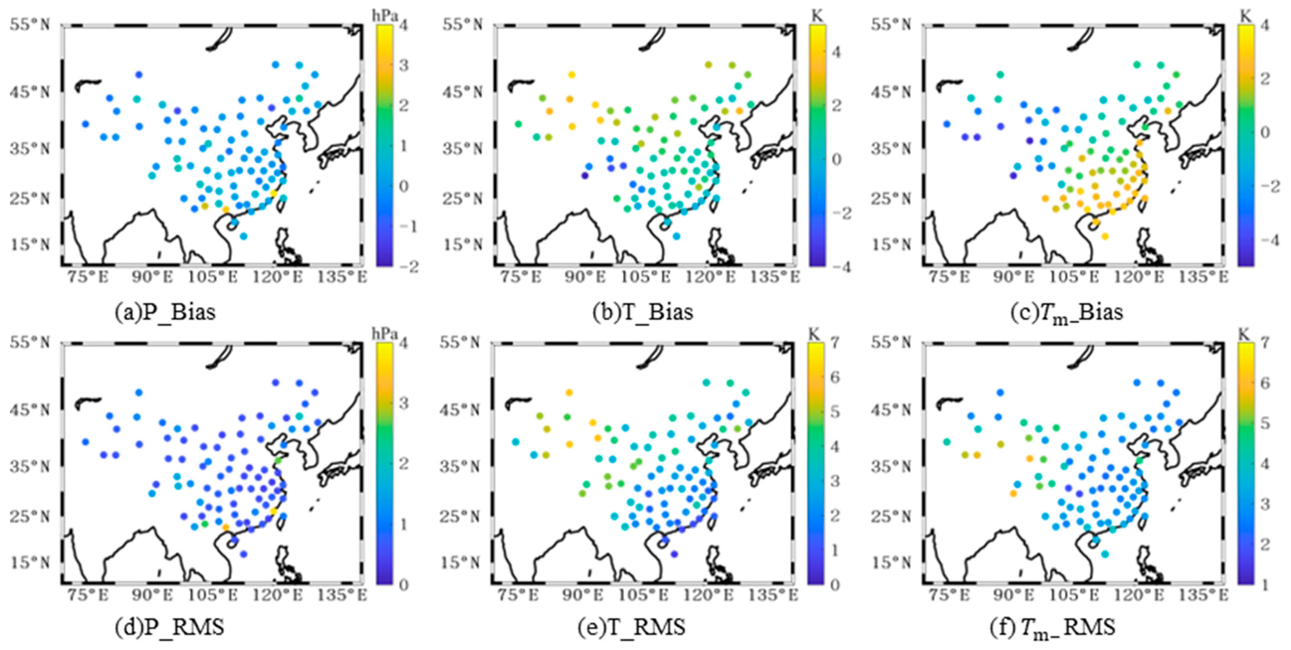
Figure 3 shows the distribution of annual mean bias and RMS for pressure, temperature, and weighted mean temperature across various stations in China. As shown in the figure, the annual mean bias for pressure is mainly distributed between −1 and 1 hPa, the Bias for temperature ranges from −4 to 4 K, and the Bias for weighted mean temperature is primarily distributed between −5 and 3 K. The temperature and weighted mean temperature generally exhibit a trend for lower accuracy in the northwestern inland areas and higher accuracy in the southeastern regions. This is due to the more complex topography, higher elevation, and scarcity of meteorological stations and data in the western Qinghai–Tibet Plateau region. Since ERA5 data are the result of the assimilation of multiple meteorological datasets, the accuracy of the data is poorer in areas where data are scarce.

3.2. Analysis of PWV

To validate the accuracy of PWV inversion based on ERA5, the experiment selected PWV data provided by 30 radiosonde stations co-located with GNSS stations as reference values. The accuracy of PWV calculated with meteorological parameters provided by empirical model (PWVG) and that derived using combined ERA5 data (PWVR) was assessed. Among them, the empirical model refers to that if there is no meteorological observation file in RINEX format when GAMIT software (v10.7) is used to calculate the PWV, and the global pressure and temperature model (GPT) is generally used to provide the meteorological parameters needed to calculate PWV. The results are shown in Table 2, and Figure 3 presents the regional distribution of bias and RMS for the PWV obtained by the two methods.
According to Table 2, the accuracy of PWVG, which uses meteorological parameters provided by an empirical model, is relatively low, with a mean RMS of 3.02 mm. After incorporating ERA5 meteorological parameters, the accuracy of PWV improved significantly, with the mean RMS of PWVR being 2.78 mm. This indicates that in the absence of measured meteorological parameters, using ERA5 data for PWV inversion in ground-based GNSS can effectively enhance accuracy, with PWVR showing an improvement of approximately 0.24 mm compared to PWVG.
In Figure 4, compared to PWVG, PWVR derived by integrating ERA5 meteorological parameters tends to be larger, with bias predominantly showing a negative distribution except in coastal areas. The RMS distribution of the two types of PWV reveals that while the overall error distribution trend remains unchanged after incorporating meteorological parameters, the accuracy has slightly improved. Overall, the accuracy of PWV inversion using ground-based GNSS is lower in the southeastern coastal regions, possibly due to the region’s reliance on the southeast monsoon for precipitation. Annual rainfall decreases gradually from the southeastern coast to the inland areas, leading to more complex and variable meteorological conditions in the southeast.

4. Research on the Response Relationship Between PWV and Meteorological Parameters

Significant progress has been made in using GNSS-derived PWVs for typhoon monitoring; however, previous studies have mainly focused on analyzing the spatiotemporal characteristics of PWV, with less attention given to the intrinsic relationship between PWV and meteorological parameters. The aforementioned study demonstrates that meteorological parameters provided by ERA5 have good applicability in China, and combining GNSS and ERA5 data for PWV inversion is feasible. Therefore, this paper proposes a WTC-based analysis method for the response relationship between PWV and meteorological parameters. By using the PWV provided by GNSS and ERA5 and the meteorological parameters provided by ERA5, the response relationship between PWV and different meteorological parameters before and after typhoon events is studied in time–frequency domain.

4.1. Typhoon Lekima

On 3 August 2019, at 18:00 Coordinated Universal Time (UTC), typhoon Lekima formed over the waters east of the Philippines. It subsequently made landfall along the coast of Wenling City in Zhejiang Province and Qingdao City in Shandong Province. This typhoon was the fifth strongest to make landfall on mainland China since 1949, causing severe damage and losses in the southeastern coastal regions. Figure 5 illustrates the path of typhoon Lekima and the distribution of GNSS stations in Zhejiang and Shandong provinces.
Typhoon Lekima made landfall along the coast of Wenling, Zhejiang, at 18:00 on 9 August, when it was closest to the Wenzhou GNSS station (ZJWZ) in Zhejiang. It then passed between the Jiande (ZJJD) and Zhoushan (ZJZS) stations in Zhejiang between 03:00 and 09:00 on 10 August. Therefore, this study primarily selects data from the ZJWZ station from August 7 to 9 and data from the ZJJD and ZJZS stations from August 8 to 10 to investigate the changes in meteorological parameters before and during the typhoon’s landfall. On 11 August at 12:00, typhoon Lekima made a second landfall in Qingdao, Shandong, and then lingered in Laizhou Bay from 18:00 on 11 August until 21:00 on 12 August, before departing on 13 August. Compared to Zhejiang, Shandong experienced a longer duration of typhoon impact. Due to missing data from some stations, this study primarily analyzes data from the Changyi (SDCY), Linyi (SDLY), and Tai’an (TAIN) stations in Shandong from August 12 to 14 to study the typhoon’s lingering effects after landfall.

4.2. Analysis of the Response Relationship Between PWV and Pressure

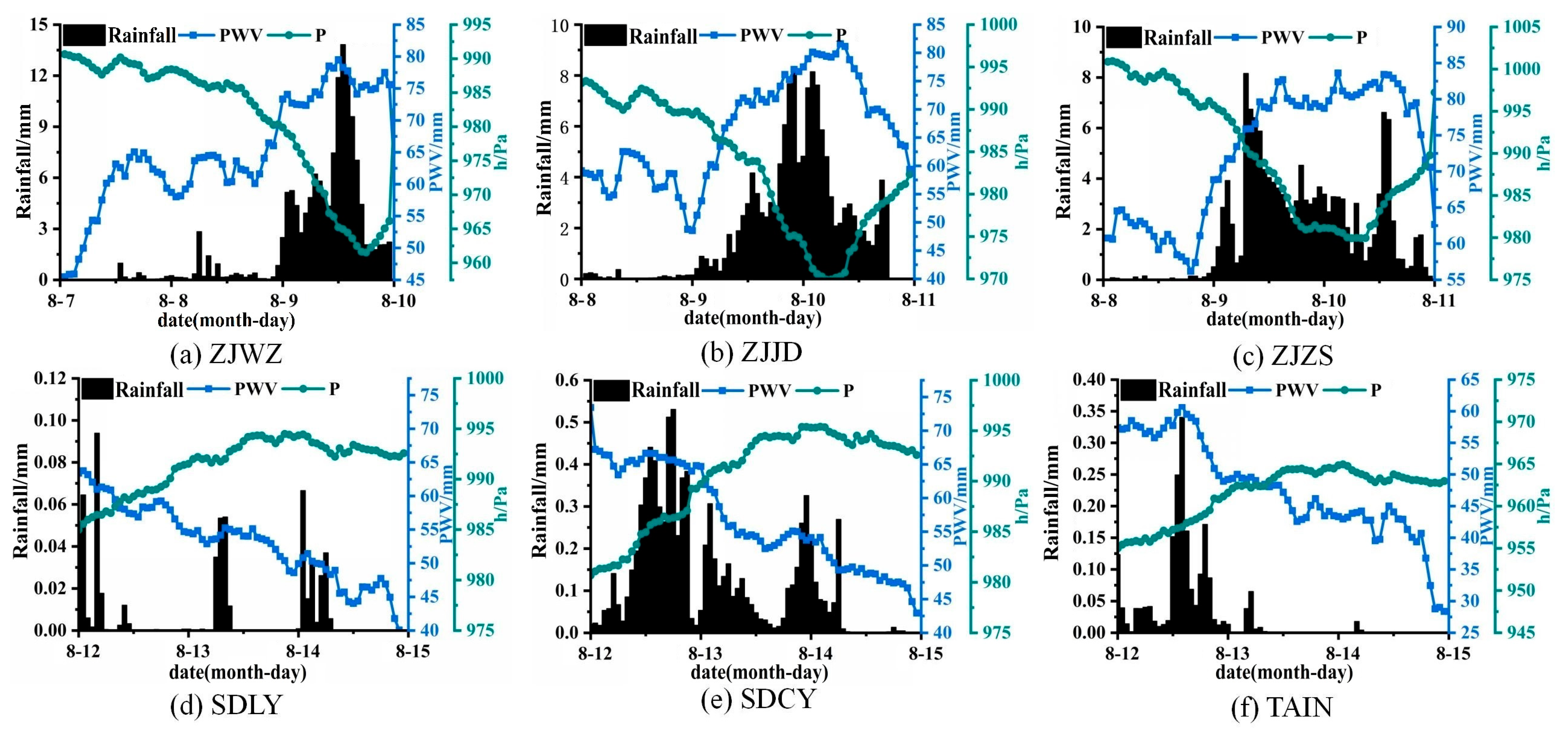
Figure 6 shows the variation trends in PWV, rainfall, and pressure during the typhoon at GNSS stations, with PWV derived by combining ERA5 meteorological data. Based on the trends observed at the ZJWZ and ZJJD stations, it can be seen that in the two days prior to the typhoon’s passage, the atmospheric water vapor content remained relatively stable, with a PWV around 60 mm. During this period, rainfall was minimal, and pressure gradually decreased. One day before the typhoon’s arrival, atmospheric water vapor began to accumulate, accompanied by intermittent showers, and the rate of pressure decline increased sharply. When the typhoon was closest to the stations, both PWV and rainfall reached their peak values, while pressure hit its lowest point. Subsequently, as atmospheric water vapor had accumulated to a significant extent, heavy rainfall occurred, leading to a rapid decrease in PWV, while pressure gradually recovered. In contrast to the ZJWZ and ZJJD stations, the ZJZS station, located in a coastal area, was affected by the typhoon as early as August 9 when it made landfall in Zhejiang, resulting in heavy rainfall. The subsequent continuous rainfall kept the atmospheric water vapor content at a high level, and when the typhoon approached the ZJZS station, the rainfall once again peaked. The air pressure trend at the ZJZS station was consistent with that of the ZJWZ and ZJJD stations, closely following the typhoon’s path, and was not significantly affected by its coastal location.
Based on the trends observed in Figure 6d–f, as the typhoon gradually moved away from Shandong, it was accompanied by light rain, and the pressure gradually recovered, eventually stabilizing at a relatively steady level. Unlike the GNSS stations in Zhejiang Province, there was no significant minimum pressure in Shandong Province, as the typhoon hovered near the Laizhou Bay on the 12th, causing a prolonged impact on the GNSS stations in Zhejiang. In contrast to the pressure trends, after the typhoon moved away, the PWV at the SDLY station began to decrease continuously from the 12th, while the PWV at the SDCY and TAIN stations remained relatively stable on the 12th, before gradually declining. This is because the typhoon was closest to the SDLY station when it passed through the Yellow Sea early on the 11th and had moved away from the SDLY station by the 12th, hovering near the Laizhou Bay, causing the PWV at the SDCY and TAIN stations to remain elevated for a period due to the typhoon’s lingering presence. Additionally, the PWV at the TAIN station was significantly lower than that at the SDCY station, as the TAIN station is located in the western part of Shandong Province, farther from the typhoon, and thus less affected. Overall, during the typhoon’s passage, the PWV exhibited an initial rise, followed by a decline, while pressure showed an initial decline, followed by a rise, indicating a clear negative correlation between the two.
To further explore the correlation between PWV and meteorological parameters in the time–frequency domain during the typhoon’s passage, Figure 7 presents the wavelet coherence spectra of PWV and pressure. As shown in Figure 7a–c, on the eve of the typhoon’s arrival, the PWV at the ZJWZ station exhibited a notable correlation with pressure from 04:00 to 10:00 on 9 August, with a correlation coefficient of 0.8 and arrows primarily pointing upward, indicating that PWV lagged behind pressure changes. At the ZJJD station, PWV and pressure showed a strong correlation from 02:00 to 10:00 on 9 August, with a correlation coefficient of 0.8, and arrows primarily pointing to the lower right, indicating that PWV led pressure changes. From 17:00 to 24:00 on the 9th, the correlation coefficient reached 0.8, and arrows pointed to the upper right, indicating that PWV was in phase with pressure but lagged behind pressure changes. Due to its geographical location, the PWV at the ZJZS station remained elevated from August 9th, and significant correlation with pressure on the eve of the typhoon’s arrival was not evident. Overall, at the ZJWZ and ZJJD stations, PWV lagged behind pressure changes on the day before the typhoon’s arrival. Compared with the trend graphs in Figure 5, this can be attributed to the typhoon gradually approaching the stations, leading to an accumulation of atmospheric water vapor to a certain extent, where PWV changes were not significant, while pressure was rapidly declining.
As shown in Figure 7d–f, after the typhoon’s departure, the PWV at the SDLY station exhibited a significant correlation with pressure in the early hours of the 14th, with a correlation coefficient of 0.75 and arrows mainly pointing to the left, indicating a negative correlation between PWV and pressure. The PWV at the SDCY station showed a strong correlation with pressure from 06:00 to 08:00 on the 13th, with arrows primarily pointing to the lower right, indicating that PWV led pressure changes. The PWV at the TAIN station exhibited a strong correlation with pressure from 12:00 on the 13th to 06:00 on the 14th, with arrows primarily pointing to the upper left, indicating that PWV was out of phase with pressure and PWV led pressure changes. Overall, after the typhoon’s departure, PWV led pressure changes. Compared with the trend graphs in Figure 6, this can be attributed to the typhoon gradually moving away from the stations, where pressure at the stations gradually returned to normal values and stabilized, while atmospheric water vapor continued to decrease.

4.3. Analysis of the Response Relationship Between PWV and Temperature

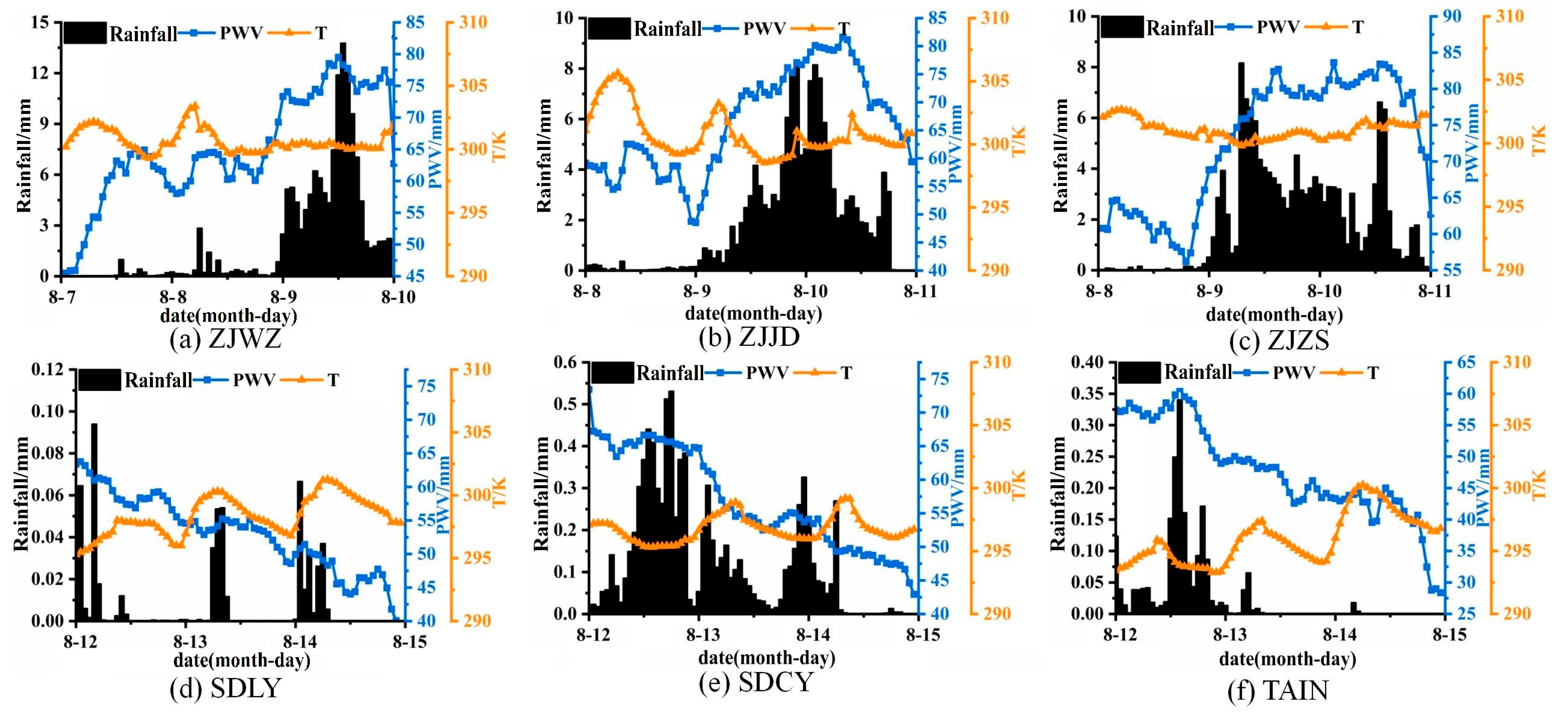
Figure 8 illustrates the trends in PWV, rainfall, and temperature during the typhoon event, with PWV derived by combining ERA5 meteorological data. The Figure shows that temperature variations during the typhoon’s passage are influenced by multiple factors, making the trend more complex. There were no significant changes in temperature during the typhoon’s passage; however, before and after the typhoon, the timing of temperature changes coincided with the timing of precipitation. This is because, before rainfall, subsidence of airflow and the ascent of air can cause a slight temperature increase, while after rainfall, the descent of rain to the ground carries away a substantial amount of heat.
To further analyze the local characteristics of PWV and temperature, Figure 9 presents the wavelet coherence spectra of PWV and temperature. Figure 9a,b indicate that, before the typhoon’s passage, PWV and temperature at the ZJWZ and ZJJD stations were significantly correlated from August 7th to 8th and from August 8th to 9th, respectively, with arrows pointing upwards, indicating that PWV lagged behind temperature changes. Due to its geographical location, the ZJZS station was influenced by the typhoon for an extended period. Unlike the continuous, long-term, significant correlation seen at the ZJWZ and ZJJD stations, the ZJZS station showed significant correlations during the periods from 19:00 to 24:00 on 8 August and from 10:00 to 14:00 on 9 August, with arrows pointing to the lower left and upper right, respectively, indicating that PWV lagged behind temperature changes. In summary, on the eve of the typhoon’s arrival, PWV lagged behind temperature changes.
Figure 9d–f display the local characteristics of PWV and temperature after the typhoon’s passage at the GNSS stations. The figures reveal that the two regions of significant correlation between PWV and temperature at the SDLY station on 13 August correspond to the rainfall observed at the SDLY station on the morning of August 13th and 14th. The significant correlation areas between PWV and temperature at the SDCY station from 20:00 to 24:00 on the 12th and from 00:00 to 01:00 on the 14th correspond to the showers observed on August 13th and 14th. At the TAIN station, the significant correlation area between PWV and temperature from 02:00 to 08:00 on the 14th corresponds to the light rain on August 14th. Thus, after the typhoon’s departure, the times of significant correlation between PWV and temperature tended to coincide with the times of precipitation. The use of wavelet coherence better facilitates the analysis of the local characteristics of weather changes after the typhoon’s departure.

5. Discussion and Conclusions

Water vapor is the most dynamic component in the atmosphere, and accurately measuring its content and trends is critical for studying weather variations. However, the absence of measured meteorological parameters at some GNSS stations poses significant challenges for ground-based GNSS water vapor inversion. With the continuous development and refinement of reanalysis datasets, particularly those provided by the ECMWF, the ERA5 dataset has emerged as a key resource for obtaining meteorological parameters.
In this study, we assessed the applicability of ERA5 meteorological parameters across China and explored the feasibility of using ERA5 data to retrieve PWV in combination with GNSS observations. Our analysis revealed that the annual mean RMS for pressure, temperature, and T m derived from ERA5 data are 0.91 hPa, 3.05 K, and 3.30 K, respectively, indicating a high level of accuracy and suitability for application in China. Furthermore, the annual mean RMS error of PWV retrieved using combined GNSS and ERA5 data is 2.78 mm, representing an accuracy improvement of approximately 0.24 mm compared to retrievals without measured meteorological parameters, thus making it well-suited for GNSS-based water vapor retrieval.
In 2019, super typhoon Lekima made successive landfalls in Zhejiang and Shandong provinces, causing extensive damage and significant losses in the southeastern coastal regions of China. Extreme weather events like typhoons are often characterized by rapid formation and evolution. Traditional water vapor detection methods, due to their low temporal resolution, struggle to capture the rapid changes in water vapor associated with such events. Moreover, remote-sensing techniques commonly focus on large-scale areas, making it challenging to accurately analyze extreme weather at smaller scales.
GNSS inversion PWV offers high temporal resolution and is unaffected by weather conditions, providing a significant advantage over traditional observation methods. This allows for the short-term analysis of extreme weather events in localized areas. While there have been numerous studies on the application of GNSS–PWV in typhoon monitoring, most of the existing research has concentrated on the spatiotemporal characteristics of PWV, with limited attention given to the relationship between PWV and meteorological parameters in typhoon forecasting.
Thus, based on PWV data derived from the combined GNSS and ERA5 datasets, this study applies WTC to examine the correlation between PWV and pressure and temperature during typhoon Lekima, as well as the spatiotemporal patterns of these interactions. The specific data processing and results are shown in Figure 10.
In conclusion, throughout the typhoon’s passage, PWV and pressure exhibit a significant negative correlation. Before the typhoon’s arrival, PWV lags behind pressure changes, whereas after the typhoon passes, PWV leads pressure changes. The correlated changes between PWV and pressure reveal distinct stages before and after the typhoon’s passage. Before the typhoon’s arrival, PWV lags behind temperature changes. After the typhoon passes, the significant correlation between PWV and temperature can indicate precipitation events following the typhoon’s departure.
This study improves PWV retrieval accuracy by integrating ERA5 and GNSS data, addressing the lack of measured meteorological parameters. The use of WTC also offers new insights into the time–frequency relationships between PWV and meteorological parameters during extreme weather events. However, while the combined ERA5 and GNSS approach demonstrated promising results during typhoon Lekima, its applicability requires further validation across other extreme weather events and regions.

Author Contributions

Conceptualization, X.W.; methodology, X.W.; formal analysis, Y.G.; data curation, Y.G.; writing—original draft preparation, Y.G.; writing—review and editing, X.W.; visualization, Y.G.; supervision, X.W.; project administration, X.W.; funding acquisition, X.W. All authors have read and agreed to the published version of the manuscript.

Funding

This research was funded by National Nature Science Foundation of China (42474048, 41804005).

Institutional Review Board Statement

Not applicable.

Informed Consent Statement

Not applicable.

Data Availability Statement

The data from China Earthquake Networks Center, except for certain datasets like the China Earthquake Quick Report Catalog, require a data request through the website by placing an order, rather than being directly downloadable.

Acknowledgments

The authors would like to express their sincere gratitude to the China Earthquake Networks Center, the China Meteorological Administration Typhoon Network, the University of Wyoming and the European Centre for Medium-Range Weather Forecasting (ECMWF) for the provision of data and products.

Conflicts of Interest

The authors declare no conflicts of interest.

References

  1. Solomon, S.; Rosenlof, K.H.; Portmann, R.W.; Daniel, J.S.; Davis, S.M.; Sanford, T.J.; Plattner, G.-K. Contributions of stratospheric water vapor to decadal changes in the rate of global warming. Science 2010, 327, 1219–1223. [Google Scholar] [CrossRef] [PubMed]
  2. Choy, S.; Wang, C.; Zhang, K.; Kuleshov, Y. GPS sensing of precipitable water vapour during the March 2010 Melbourne storm. Adv. Space Res. 2013, 52, 1688–1699. [Google Scholar] [CrossRef]
  3. Huang, L.; Mo, Z.; Xie, S.; Liu, L.; Chen, J.; Kang, C.; Wang, S. Spatiotemporal characteristics of GNSS-derived precipitable water vapor during heavy rainfall events in Guilin, China. Satell. Navig. 2021, 2, 1–17. [Google Scholar] [CrossRef]
  4. Hsu, P.C.; Li, T.; You, L.; Gao, J.; Ren, H.L. A spatial–temporal projection model for 10–30 day rainfall forecast in South China. Clim. Dyn. 2015, 44, 1227–1244. [Google Scholar] [CrossRef]
  5. Bevis, M.; Businger, S.; Herring, T.A.; Rocken, C.; Anthes, R.A.; Ware, R.H. GPS meteorology: Remote sensing of atmospheric water vapor using the global positioning system. J. Geophys. Res. Atmos. 1992, 97, 15787–15801. [Google Scholar] [CrossRef]
  6. Emardson, T.R.; Elgered, G.; Johansson, J.M. Three months of continuous monitoring of atmospheric water vapor with a network of Global Positioning System receivers. Geophys. Res. Atmos. 1998, 103, 1807–1820. [Google Scholar] [CrossRef]
  7. Vaquero-Martínez, J.; Antón, M.; de Galisteo, J.P.O.; Cachorro, V.E.; Wang, H.; Abad, G.G.; Román, R.; Costa, M.J. Validation of integrated water vapor from OMI satellite instrument against reference GPS data at the Iberian Peninsula. Sci. Total Environ. 2017, 580, 857–864. [Google Scholar] [CrossRef]
  8. Barman, P.; Jade, S.; Kumar, A.; Jamir, W. Inter annual, spatial, seasonal, and diurnal variability of precipitable water vapour over northeast India using GPS time series. Int. J. Remote Sens. 2016, 38, 391–411. [Google Scholar] [CrossRef]
  9. Ning, T.; Wang, J.; Elgered, G.; Dick, G.; Wickert, J.; Bradke, M.; Sommer, M.; Querel, R.; Smale, D. The uncertainty of the atmospheric integrated water vapour estimated from GNSS observations. Atmos. Meas. Tech. 2016, 9, 79–92. [Google Scholar] [CrossRef]
  10. Shoji, Y.; Sato, K.; Yabuki, M.; Tsuda, T. Comparison of shipborne GNSS-derived precipitable water vapor with radiosonde in the western North Pacific and in the seas adjacent to Japan. Earth Planets Space 2017, 69, 153. [Google Scholar] [CrossRef]
  11. Zhang, H.; Yuan, Y.; Li, W.; Zhang, B. A real-time precipitable water vapor monitoring system using the national GNSS network of China: Method and preliminary results. IEEE J. Sel. Top. Appl. Earth Obs. Remote Sens. 2019, 12, 1587–1598. [Google Scholar] [CrossRef]
  12. Wang, J.; Wu, Z.; Semmling, M.; Zus, F.; Gerland, S.; Ramatschi, M.; Ge, M.; Wickert, J.; Schuh, H. Retrieving precipitable water vapor from shipborne multi-GNSS observations. Geophys. Res. Lett. 2019, 46, 5000–5008. [Google Scholar] [CrossRef]
  13. Zhao, Q.; Yao, Y.; Yao, W.; Zhang, S. GNSS-derived PWV and comparison with radiosonde and ECMWF ERA-Interim data over mainland China. J. Atmos. Sol.-Terr. Phys. 2018, 182, 85–92. [Google Scholar] [CrossRef]
  14. Champollion, C.; Masson, F.; Van Baelen, J.; Walpersdorf, A.; Chéry, J.; Doerflinger, E. GPS monitoring of the tropospheric water vapor distribution and variation during the 9 September 2002 torrential precipitation episode in the Cévennes (southern France). J. Geophys. Res. Atmos. 2004, 109, D24102. [Google Scholar] [CrossRef]
  15. Li, L.; Zhang, K.; Wu, S.; Li, H.; Wang, X.; Hu, A.; Shen, Z. An improved method for rainfall forecast based on GNSS-PWV. Remote Sens. 2022, 14, 4280. [Google Scholar] [CrossRef]
  16. Guo, M.; Zhang, H.; Xia, P. Exploration and analysis of the factors influencing GNSS PWV for nowcasting applications. Adv. Space Res. 2021, 67, 3960–3978. [Google Scholar] [CrossRef]
  17. Wei, P.; Xie, S.; Huang, L.; Liu, L. Ingestion of GNSS-Derived ZTD and PWV for spatial interpolation of PM2. 5 concentration in Central and Southern China. Int. J. Environ. Res. Public Health 2021, 18, 7931. [Google Scholar]
  18. Zhao, Q.; Ma, X.; Yao, W.; Liu, Y.; Yao, Y. A drought monitoring method based on precipitable water vapor and precipitation. J. Clim. 2020, 33, 10727–10741. [Google Scholar] [CrossRef]
  19. Zhu, H.; Chen, K.; Hu, S.; Liu, J.; Shi, H.; Wei, G.; Chai, H.; Li, J.; Wang, T. Using the global navigation satellite system and precipitation data to establish the propagation characteristics of meteorological and hydrological drought in Yunnan, China. Water Resour. Res. 2023, 59, e2022WR033126. [Google Scholar] [CrossRef]
  20. Yeh, T.-K.; Hong, J.-S.; Wang, C.-S.; Chen, C.-H.; Chen, K.-H.; Fong, C.-T. Determining the precipitable water vapor with ground-based GPS and comparing its yearly variation to rainfall over Taiwan. Adv. Space Res. 2016, 57, 2496–2507. [Google Scholar] [CrossRef]
  21. Liu, J.C.; Zhong, W.; Shuang LI, U.; Lu, H.C. Allocation difference analyses of water substances during typhoon landing processes. J. Trop. Meteorol. 2018, 24, 300–313. [Google Scholar]
  22. Xu, H.; Zhai, G.; Li, X. Convective-stratiform rainfall separation of typhoon Fitow (2013): A 3D WRF modeling study. Terr. Atmos. Ocean. Sci. 2018, 29, 315–329. [Google Scholar] [CrossRef]
  23. Qi-Hua, L.L.; Han-Cheng, L.L.; Wei, Z.Z.; Wei-Chao, W.W.; Xing-Liang, G.G.; Meng, Y.Y. Meso-scale transport characteristics and budget diagnoses of water vapor in binary typhoons. Acta Phys. Sin. 2018, 67, 039201. [Google Scholar] [CrossRef]
  24. Zhao, Q.; Yao, Y.; Yao, W. GPS-based PWV for precipitation forecasting and its application to a typhoon event. J. Atmos. Solar-Terrestrial Phys. 2018, 167, 124–133. [Google Scholar] [CrossRef]
  25. He, Q.; Zhang, K.; Wu, S.; Zhao, Q.; Wang, X.; Shen, Z.; Li, L.; Wan, M.; Liu, X. Real-time GNSS-derived PWV for typhoon characterizations: A case study for super typhoon Mangkhut in Hong Kong. Remote Sens. 2019, 12, 104. [Google Scholar] [CrossRef]
  26. Zhu, M.; Liu, Z.; Hu, W. Observing water vapor variability during three super typhoon events in Hong Kong based on GPS water vapor tomographic modeling technique. J. Geophys. Res. Atmos. 2020, 125, e2019JD032318. [Google Scholar] [CrossRef]
  27. Zhao, Q.; Ma, X.; Yao, W.; Yao, Y. A new typhoon-monitoring method using precipitation water vapor. Remote Sens. 2019, 11, 2845. [Google Scholar] [CrossRef]
  28. Li, Z.; Wang, J.; Wei, C.; Yu, J. Analysis of the Temporal and Spatial Characteristics of PWV and Rainfall with the Typhoon Movement: A Case Study of ‘Meihua’in 2022. Atmosphere 2023, 14, 1313. [Google Scholar] [CrossRef]
  29. Grinsted, A.; Moore, J.C.; Jevrejeva, S. Application of the cross wavelet transform and wavelet coherence to geophysical time series. Nonlinear Process. Geophys. 2004, 11, 561–566. [Google Scholar] [CrossRef]
  30. Li, K.J.; Gao, P.X.; Zhan, L.S.; Shi, X.J.; Zhu, W.W. Relative phase analyses of long-term hemispheric solar flare activity. Mon. Not. R. Astron. Soc. 2009, 401, 342–346. [Google Scholar] [CrossRef]
  31. Tomás, R.; Li, Z.; Lopez-Sanchez, J.M.; Liu, P.; Singleton, A. Using wavelet tools to analyse seasonal variations from InSAR time-series data: A case study of the Huangtupo landslide. Landslides 2015, 13, 437–450. [Google Scholar] [CrossRef]
  32. Li, F.; He, L. The effects of dominant driving forces on summer precipitation during different periods in Beijing. Atmosphere 2017, 8, 44. [Google Scholar] [CrossRef]
  33. Ebrahimi, A.; Rahimi, D.; Joghataei, M.; Movahedi, S. Correlation wavelet analysis for linkage between winter precipitation and three oceanic sources in Iran. Environ. Process. 2021, 8, 1027–1045. [Google Scholar] [CrossRef]
  34. Saastamoinen, J. Introduction to practical computation of astronomical refraction. Bull. Géod. 1972, 106, 383–397. [Google Scholar] [CrossRef]
  35. Li, L.; Gao, Y.; Xu, S.; Lu, H.; He, Q.; Yu, H. The New improved ZHD and weighted mean temperature models based on GNSS and radiosonde data using GPT3 and Fourier function. Atmosphere 2022, 13, 1648. [Google Scholar] [CrossRef]
  36. Wang, J.; Zhang, L.; Dai, A.; Van Hove, T.; Van Baelen, J. A near-global, 2-hourly data set of atmospheric precipitable water from ground-based GPS measurements. J. Geophys. Res. 2007, 112, D11107. [Google Scholar] [CrossRef]
Figure 1. The phase relationship diagram between series X and Y. The red area represents a positive correlation between X and Y, while the blue area represents a negative correlation. The different directions of the arrows indicate whether X leads or lags behind Y.
Atmosphere 15 01249 g001
Figure 2. Geographic distribution of radiosonde and GNSS stations in China. The green triangle represents the position of radiosonde station, and the red five-pointed star represents the position of GNSS station.
Atmosphere 15 01249 g002
Figure 3. Spatial distribution of bias and RMS for pressure, temperature, and weighted mean temperature in China. Figure (ac) show the bias for pressure (P in hPa), temperature (T in K), and weighted mean temperature ( T m in K), respectively. Figure (df) illustrate the RMS for pressure (P in hPa), temperature (T in K), and weighted mean temperature ( T m in K), respectively. The color bars represent the magnitude of bias and RMS across the GNSS stations in the study region.
Atmosphere 15 01249 g003
Figure 4. Spatial distribution of bias and RMS for precipitable water vapor (PWV) at 30 co-located stations. Figure (a,b) show the bias for PWV calculated without measured meteorological parameters (PWVG, in mm) and PWV derived using combined ERA5 data (PWVR, in mm), respectively. Figure (c,d) illustrate the RMS for PWVG and PWVR, respectively. The color bars represent the magnitude of bias and RMS across the GNSS stations in the study region.
Atmosphere 15 01249 g004
Figure 5. Track of typhoon Lekima and GNSS Stations in two provinces. The blue curve represents the typhoon movement route, and the red triangle represents the GNSS station.
Atmosphere 15 01249 g005
Figure 6. Trends in PWV, rainfall, and pressure at GNSS stations during the typhoon. The black bars represent the rainfall (in mm). The blue line indicates the precipitable water vapor (PWV in mm), and the green line shows the pressure (P in hPa). Each subfigure corresponds to different GNSS stations: (a) ZJWZ, (b) ZJJD, (c) ZJZS, (d) SDLY, (e) SDCY, and (f) TAIN.
Atmosphere 15 01249 g006
Figure 7. Wavelet coherence spectrum of PWV and pressure at GNSS stations during the typhoon. The thick contour marks the regions where coherence is significant at the 5% level against red noise. The cone of influence (COI), where edge effects may affect the results, is shaded lighter. Arrows indicate the relative phase relationship: arrows pointing to the right signify in-phase behavior, to the left indicate anti-phase, and upward or downward arrows denote whether PWV lags or leads pressure. Each subfigure corresponds to different GNSS stations: (a) ZJWZ, (b) ZJJD, (c) ZJZS, (d) SDLY, (e) SDCY, and (f) TAIN.
Atmosphere 15 01249 g007
Figure 8. Trends in PWV, rainfall, and temperature at GNSS stations during the typhoon. The black bars represent the rainfall (in mm). The blue line indicates the precipitable water vapor (PWV in mm), and the orange line shows the temperature (T in K). Each subfigure corresponds to different GNSS stations: (a) ZJWZ, (b) ZJJD, (c) ZJZS, (d) SDLY, (e) SDCY, and (f) TAIN.
Atmosphere 15 01249 g008
Figure 9. Wavelet coherence spectrum of PWV and temperature at GNSS stations during the typhoon. The thick contour marks the regions where coherence is significant at the 5% level against red noise. The cone of influence (COI), where edge effects may affect the results, is shaded lighter. Arrows indicate the relative phase relationship: arrows pointing to the right signify in-phase behavior, to the left indicate anti-phase, and upward or downward arrows denote whether PWV lags or leads temperature. Each subfigure corresponds to different GNSS stations: (a) ZJWZ, (b) ZJJD, (c) ZJZS, (d) SDLY, (e) SDCY, and (f) TAIN.
Atmosphere 15 01249 g009
Figure 10. Data processing and result distribution diagram. The green rectangular area is the flowchart of the combined GNSS and ERA5 inversion of PWV, and the purple rectangular area is the summary of the response relationship between PWV and meteorological parameters based on WTC.
Atmosphere 15 01249 g010
Table 1. Statistical results of ERA5 meteorological parameters at radiosonde stations (UTC 0:00 and 12:00).
P/hPaT/K T m /K
BiasRMSBiasRMSBiasRMS
Max3.703.734.276.253.146.04
Min−1.140.45−3.820.71−4.631.83
Average0.210.911.103.050.363.30
Table 2. Statistical results of PWV at radiosonde stations (UTC 0:00 and 12:00).
PWVG/mmPWVR/mm
BiasRMSBiasRMS
Max1.765.671.086.00
Min−5.041.39−4.621.17
Average−0.283.02−1.122.78
Disclaimer/Publisher’s Note: The statements, opinions and data contained in all publications are solely those of the individual author(s) and contributor(s) and not of MDPI and/or the editor(s). MDPI and/or the editor(s) disclaim responsibility for any injury to people or property resulting from any ideas, methods, instructions or products referred to in the content.