Estimation of Surface Downward Longwave Radiation and Cloud Base Height Based on Infrared Multichannel Data of Himawari-8
Abstract
1. Introduction
2. Materials and Methods
2.1. Input Data
2.2. Validation Data
2.3. Algorithm Description
2.4. RF-CBH Model Development
2.5. RF-SDLR Model Development
3. Results and Discussion
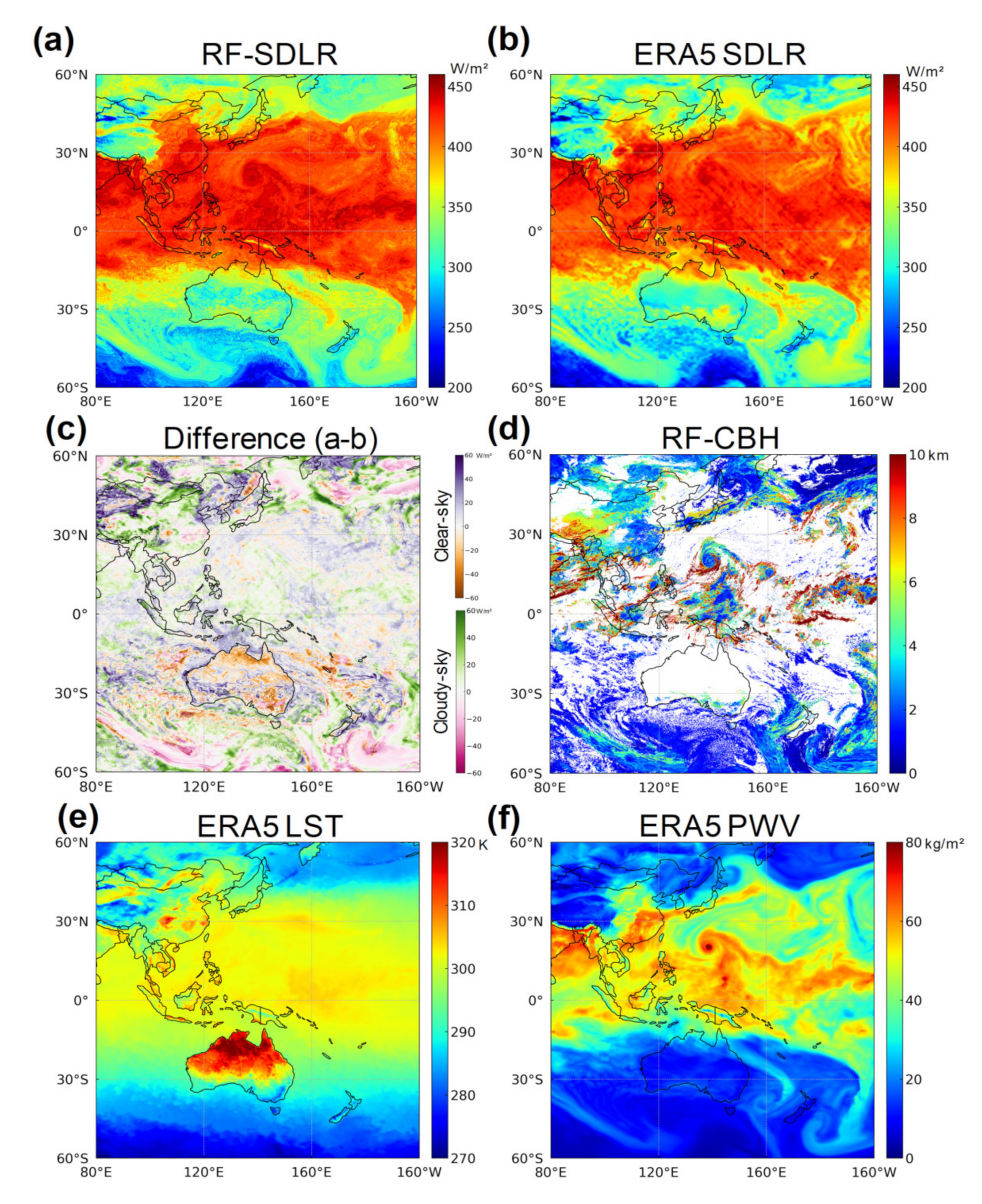
3.1. Spatial Features of the Cloud Geometric Properties and SDLR
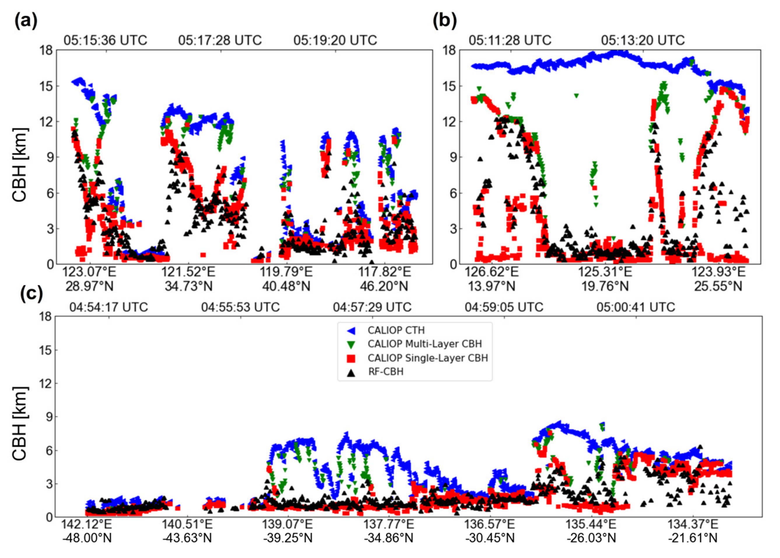
3.2. Validation of the CBH Estimation
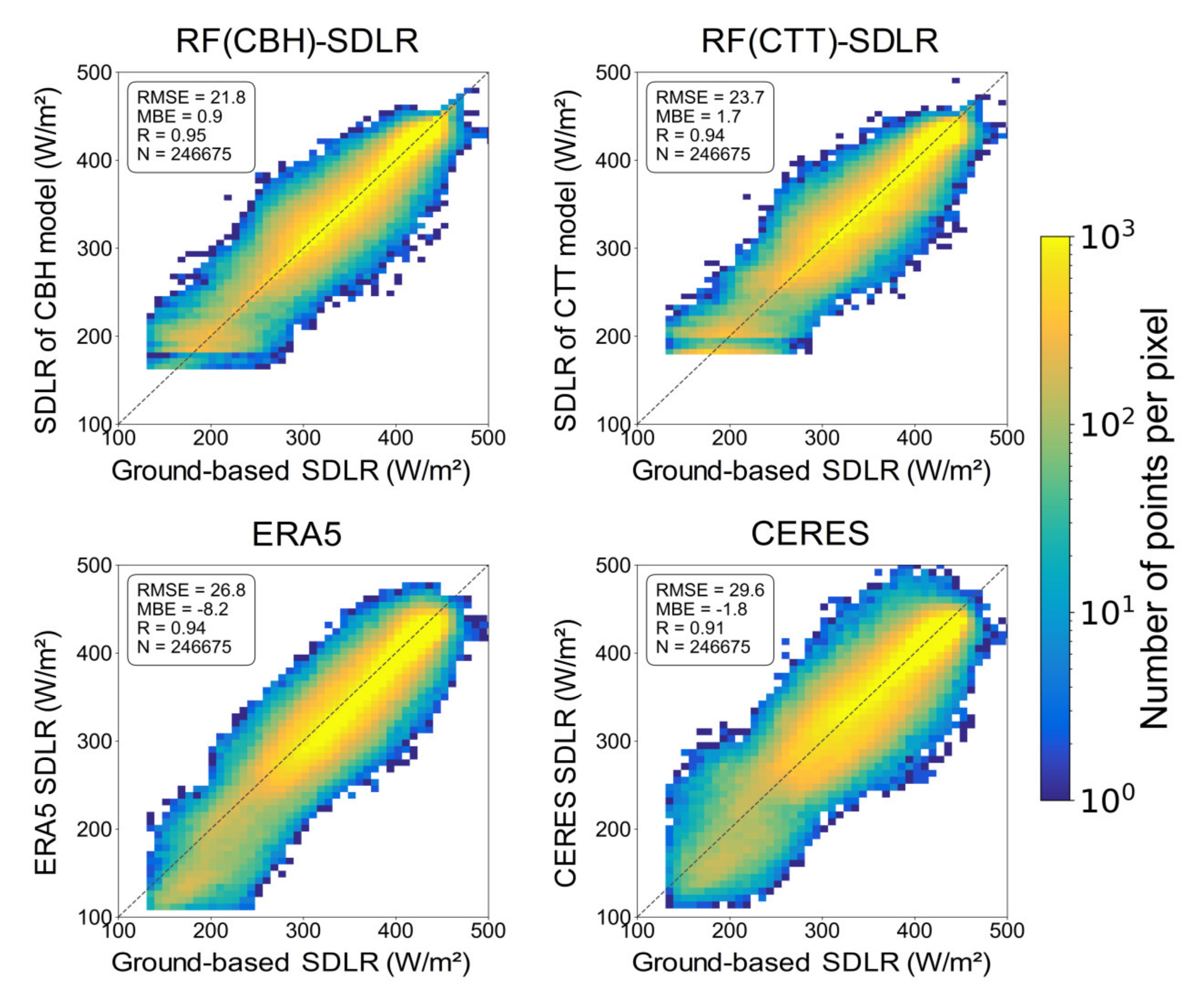
3.3. Validation of the SDLR Estimation
4. Conclusions
Author Contributions
Funding
Institutional Review Board Statement
Informed Consent Statement
Data Availability Statement
Acknowledgments
Conflicts of Interest
References
- Wang, K.; Dickinson, R.E. Global atmospheric downward longwave radiation at the surface from ground-based observations, satellite retrievals, and reanalyses. Rev. Geophys. 2013, 51, 150–185. [Google Scholar] [CrossRef]
- Yang, K.; Rasmy, M.; Rauniyar, S.; Koike, T.; Taniguchi, K.; Tamagawa, K.; Koudelova, P.; Kitsuregawa, M.; Nemoto, T.; Yasukawa, M. Initial CEOP-based review of the prediction skill of operational general circulation models and land surface models. J. Meteorol. Soc. Jpn. 2007, 85, 99–116. [Google Scholar] [CrossRef]
- Iacono, M.J.; Mlawer, E.J.; Clough, S.A.; Morcrette, J.J. Impact of an improved longwave radiation model, RRTM, on the energy budget and thermodynamic properties of the NCAR community climate model, CCM3. J. Geophys. Res. Atmos. 2000, 105, 14873–14890. [Google Scholar] [CrossRef]
- Wang, K.; Liang, S. Global atmospheric downward longwave radiation over land surface under all-sky conditions from 1973 to 2008. J. Geophys. Res. Atmos. 2009, 114, D19101. [Google Scholar] [CrossRef]
- Wild, M.; Ohmura, A.; Gilgen, H.; Morcrette, J.-J.; Slingo, A. Evaluation of downward longwave radiation in general circulation models. J. Clim. 2001, 14, 3227–3239. [Google Scholar] [CrossRef]
- Yang, K.; He, J.; Tang, W.; Qin, J.; Cheng, C.C. On downward shortwave and longwave radiations over high altitude regions: Observation and modeling in the Tibetan Plateau. Agric. For. Meteorol. 2010, 150, 38–46. [Google Scholar] [CrossRef]
- Yang, F.; Cheng, J. A framework for estimating cloudy sky surface downward longwave radiation from the derived active and passive cloud property parameters. Remote Sens. Environ. 2020, 248, 111972. [Google Scholar] [CrossRef]
- Jiao, Z.-H.; Mu, X. Global validation of clear-sky models for retrieving land-surface downward longwave radiation from MODIS data. Remote Sens. Environ. 2022, 271, 112903. [Google Scholar] [CrossRef]
- Prata, A. A new long-wave formula for estimating downward clear-sky radiation at the surface. Q. J. R. Meteorol. Soc. 1996, 122, 1127–1151. [Google Scholar] [CrossRef]
- Bisht, G.; Bras, R.L. Estimation of net radiation from the MODIS data under all sky conditions: Southern Great Plains case study. Remote Sens. Environ. 2010, 114, 1522–1534. [Google Scholar] [CrossRef]
- Wang, T.; Shi, J.; Yu, Y.; Husi, L.; Gao, B.; Zhou, W.; Ji, D.; Zhao, T.; Xiong, C.; Chen, L. Cloudy-sky land surface longwave downward radiation (LWDR) estimation by integrating MODIS and AIRS/AMSU measurements. Remote Sens. Environ. 2018, 205, 100–111. [Google Scholar] [CrossRef]
- Wang, T.; Shi, J.; Ma, Y.; Letu, H.; Li, X. All-sky longwave downward radiation from satellite measurements: General parameterizations based on LST, column water vapor and cloud top temperature. ISPRS J. Photogramm. Remote Sens. 2020, 161, 52–60. [Google Scholar] [CrossRef]
- Duan, S.-B.; Li, Z.-L.; Tang, B.-H.; Wu, H.; Tang, R. Direct estimation of land-surface diurnal temperature cycle model parameters from MSG–SEVIRI brightness temperatures under clear sky conditions. Remote Sens. Environ. 2014, 150, 34–43. [Google Scholar] [CrossRef]
- Gao, B.C.; Kaufman, Y.J. Water vapor retrievals using Moderate Resolution Imaging Spectroradiometer (MODIS) near-infrared channels. J. Geophys. Res. Atmos. 2003, 108, 4389. [Google Scholar] [CrossRef]
- Li, Z.-L.; Becker, F. Feasibility of land surface temperature and emissivity determination from AVHRR data. Remote Sens. Environ. 1993, 43, 67–85. [Google Scholar] [CrossRef]
- Ma, H.; Liang, S.; Xiao, Z.; Shi, H. Simultaneous inversion of multiple land surface parameters from MODIS optical–thermal observations. ISPRS J. Photogramm. Remote Sens. 2017, 128, 240–254. [Google Scholar] [CrossRef]
- Wan, Z.; Dozier, J. A generalized split-window algorithm for retrieving land-surface temperature from space. IEEE Trans. Geosci. Remote Sens. 1996, 34, 892–905. [Google Scholar]
- Wu, Y.; Zhang, F.; Wu, K.; Min, M.; Li, W.; Liu, R. Best water vapor information layer of Himawari-8-based water vapor bands over east Asia. Sensors 2020, 20, 2394. [Google Scholar] [CrossRef]
- Dong, S.; Cheng, J.; Shi, J.; Shi, C.; Sun, S.; Liu, W. A Data Fusion Method for Generating Hourly Seamless Land Surface Temperature from Himawari-8 AHI Data. Remote Sens. 2022, 14, 5170. [Google Scholar] [CrossRef]
- Kato, S.; Rose, F.G.; Sun−Mack, S.; Miller, W.F.; Chen, Y.; Rutan, D.A.; Stephens, G.L.; Loeb, N.G.; Minnis, P.; Wielicki, B.A. Improvements of top-of-atmosphere and surface irradiance computations with CALIPSO-, CloudSat-, and MODIS-derived cloud and aerosol properties. J. Geophys. Res. Atmos. 2011, 116, D19209. [Google Scholar] [CrossRef]
- Zhang, Y.; Rossow, W.B.; Lacis, A.A.; Oinas, V.; Mishchenko, M.I. Calculation of radiative fluxes from the surface to top of atmosphere based on ISCCP and other global data sets: Refinements of the radiative transfer model and the input data. J. Geophys. Res. Atmos. 2004, 109, D19105. [Google Scholar] [CrossRef]
- Jiang, Y.; Tang, B.-H.; Zhao, Y. Estimation of Downwelling Surface Longwave Radiation with the Combination of Parameterization and Artificial Neural Network from Remotely Sensed Data for Cloudy Sky Conditions. Remote Sens. 2022, 14, 2716. [Google Scholar] [CrossRef]
- Stephens, G.L.; Wild, M.; Stackhouse, P.W.; L’Ecuyer, T.; Kato, S.; Henderson, D.S. The global character of the flux of downward longwave radiation. J. Clim. 2012, 25, 2329–2340. [Google Scholar] [CrossRef]
- Yu, S.; Li, L.; Cao, B.; Zhang, H.; Zhu, L.; Xin, X.; Liu, Q. Surface downward longwave radiation estimation from new generation geostationary satellite data. Atmos. Res. 2022, 276, 106255. [Google Scholar] [CrossRef]
- Carmona, F.; Rivas, R.; Caselles, V. Estimation of daytime downward longwave radiation under clear and cloudy skies conditions over a sub-humid region. Theor. Appl. Climatol. 2014, 115, 281–295. [Google Scholar] [CrossRef]
- Lhomme, J.-P.; Vacher, J.J.; Rocheteau, A. Estimating downward long-wave radiation on the Andean Altiplano. Agric. For. Meteorol. 2007, 145, 139–148. [Google Scholar] [CrossRef]
- Crawford, T.M.; Duchon, C.E. An improved parameterization for estimating effective atmospheric emissivity for use in calculating daytime downwelling longwave radiation. J. Appl. Meteorol. Climatol. 1999, 38, 474–480. [Google Scholar] [CrossRef]
- Duarte, H.F.; Dias, N.L.; Maggiotto, S.R. Assessing daytime downward longwave radiation estimates for clear and cloudy skies in Southern Brazil. Agric. For. Meteorol. 2006, 139, 171–181. [Google Scholar] [CrossRef]
- Gaumet, J.; Heinrich, J.; Cluzeau, M.; Pierrard, P.; Prieur, J. Cloud-base height measurements with a single-pulse erbium-glass laser ceilometer. J. Atmos. Ocean. Technol. 1998, 15, 37–45. [Google Scholar] [CrossRef]
- Takano, T.; Yamaguchi, J.; Abe, H.; Futaba, K.I.; Yokote, S.I.; Kawamura, Y.; Takamura, T.; Kumagai, H.; Ohno, Y.; Nakanishi, Y. Development and performance of the millimeter-wave cloud profiling radar at 95 GHz: Sensitivity and spatial resolution. Electron. Commun. Jpn. 2010, 93, 42–49. [Google Scholar] [CrossRef]
- Marchand, R.; Mace, G.G.; Ackerman, T.; Stephens, G. Hydrometeor detection using CloudSat—An Earth-orbiting 94-GHz cloud radar. J. Atmos. Ocean. Technol. 2008, 25, 519–533. [Google Scholar] [CrossRef]
- Noh, Y.-J.; Forsythe, J.M.; Miller, S.D.; Seaman, C.J.; Li, Y.; Heidinger, A.K.; Lindsey, D.T.; Rogers, M.A.; Partain, P.T. Cloud-base height estimation from VIIRS. Part II: A statistical algorithm based on A-Train satellite data. J. Atmos. Ocean. Technol. 2017, 34, 585–598. [Google Scholar] [CrossRef]
- Bessho, K.; Date, K.; Hayashi, M.; Ikeda, A.; Imai, T.; Inoue, H.; Kumagai, Y.; Miyakawa, T.; Murata, H.; Ohno, T. An introduction to Himawari-8/9-Japan’s new-generation geostationary meteorological satellites. J. Meteorol. Soc. Japan. Ser. II 2016, 94, 151–183. [Google Scholar] [CrossRef]
- Letu, H.; Nakajima, T.Y.; Wang, T.; Shang, H.; Ma, R.; Yang, K.; Baran, A.J.; Riedi, J.; Ishimoto, H.; Yoshida, M. A new benchmark for surface radiation products over the East Asia-Pacific region retrieved from the Himawari-8/AHI next-generation geostationary satellite. Bull. Am. Meteorol. Soc. 2022, 103, E873–E888. [Google Scholar] [CrossRef]
- Yang, J.; Zhang, Z.; Wei, C.; Lu, F.; Guo, Q. Introducing the new generation of Chinese geostationary weather satellites, Fengyun-4. Bull. Am. Meteorol. Soc. 2017, 98, 1637–1658. [Google Scholar] [CrossRef]
- Tan, Z.; Huo, J.; Ma, S.; Han, D.; Wang, X.; Hu, S.; Yan, W. Estimating cloud base height from Himawari-8 based on a random forest algorithm. Int. J. Remote Sens. 2021, 42, 2485–2501. [Google Scholar] [CrossRef]
- Tan, Z.; Ma, S.; Han, D.; Gao, D.; Yan, W. Estimation of cloud base height for FY-4A satellite based on random forest algorithm. J. Infrared Millim. Waves 2019, 38, 381–388. [Google Scholar]
- Lin, H.; Li, Z.; Li, J.; Zhang, F.; Min, M.; Menzel, W.P. Estimate of daytime single-layer cloud base height from advanced baseline imager measurements. Remote Sens. Environ. 2022, 274, 112970. [Google Scholar] [CrossRef]
- Hutchison, K. The retrieval of cloud base heights from MODIS and three-dimensional cloud fields from NASA’s EOS Aqua mission. Int. J. Remote Sens. 2002, 23, 5249–5265. [Google Scholar] [CrossRef]
- Min, M.; Li, J.; Wang, F.; Liu, Z.; Menzel, W.P. Retrieval of cloud top properties from advanced geostationary satellite imager measurements based on machine learning algorithms. Remote Sens. Environ. 2020, 239, 111616. [Google Scholar] [CrossRef]
- Dong, Y.; Sun, X.; Li, Q. A Method for Retrieving Cloud-Top Height Based on a Machine Learning Model Using the Himawari-8 Combined with Near Infrared Data. Remote Sens. 2022, 14, 6367. [Google Scholar] [CrossRef]
- Tang, T.; Jiao, D.; Chen, T.; Gui, G. Medium-and long-term precipitation forecasting method based on data augmentation and machine learning algorithms. IEEE J. Sel. Top. Appl. Earth Obs. Remote Sens. 2022, 15, 1000–1011. [Google Scholar] [CrossRef]
- Wang, G.; Wang, H.; Zhuang, Y.; Wu, Q.; Chen, S.; Kang, H. Tropical overshooting cloud-top height retrieval from himawari-8 imagery based on random forest model. Atmosphere 2021, 12, 173. [Google Scholar] [CrossRef]
- Ri, X.; Tana, G.; Shi, C.; Nakajima, T.Y.; Shi, J.; Zhao, J.; Xu, J.; Letu, H. Cloud, Atmospheric Radiation and Renewal Energy Application (CARE) Version 1.0 Cloud Top Property Product From Himawari-8/AHI: Algorithm Development and Preliminary Validation. IEEE Trans. Geosci. Remote Sens. 2022, 60, 1–11. [Google Scholar] [CrossRef]
- Håkansson, N.; Adok, C.; Thoss, A.; Scheirer, R.; Hörnquist, S. Neural network cloud top pressure and height for MODIS. Atmos. Meas. Tech. 2018, 11, 3177–3196. [Google Scholar] [CrossRef]
- Gribbon, K.T.; Bailey, D.G. A novel approach to real-time bilinear interpolation. In Proceedings of the DELTA 2004, Second IEEE international workshop on electronic design, test and applications, Perth, WA, Australia, 28–30 January 2004; pp. 126–131. [Google Scholar]
- Stephens, G.L.; Vane, D.G.; Boain, R.J.; Mace, G.G.; Sassen, K.; Wang, Z.; Illingworth, A.J.; O’connor, E.J.; Rossow, W.B.; Durden, S.L. The CloudSat mission and the A-Train: A new dimension of space-based observations of clouds and precipitation. Bull. Am. Meteorol. Soc. 2002, 83, 1771–1790. [Google Scholar] [CrossRef]
- Winker, D.M.; Vaughan, M.A.; Omar, A.; Hu, Y.; Powell, K.A.; Liu, Z.; Hunt, W.H.; Young, S.A. Overview of the CALIPSO mission and CALIOP data processing algorithms. J. Atmos. Ocean. Technol. 2009, 26, 2310–2323. [Google Scholar] [CrossRef]
- Miller, S.D.; Forsythe, J.M.; Partain, P.T.; Haynes, J.M.; Bankert, R.L.; Sengupta, M.; Mitrescu, C.; Hawkins, J.D.; Haar, T.H.V. Estimating three-dimensional cloud structure via statistically blended satellite observations. J. Appl. Meteorol. Climatol. 2014, 53, 437–455. [Google Scholar] [CrossRef]
- Masumoto, Y.; Murty, V.; Nobre, P.; Ravichandran, M.; Vialard, J.; Vousden, D.; Yu, W. The global tropical moored buoy array. In Proceedings of the OceanObs09: Sustained Ocean Observations and Information for Society; Miloslavich, P., Klein, E., Daz, J.M., Hernndez, C.E.S., Bigatti, G., Eds.; Campos: Venice, Italy, 2010. [Google Scholar]
- Ohmura, A.; Dutton, E.G.; Forgan, B.; Fröhlich, C.; Gilgen, H.; Hegner, H.; Heimo, A.; König-Langlo, G.; McArthur, B.; Müller, G. Baseline Surface Radiation Network (BSRN/WCRP): New precision radiometry for climate research. Bull. Am. Meteorol. Soc. 1998, 79, 2115–2136. [Google Scholar] [CrossRef]
- Driemel, A.; Augustine, J.; Behrens, K.; Colle, S.; Cox, C.; Cuevas-Agulló, E.; Denn, F.M.; Duprat, T.; Fukuda, M.; Grobe, H. Baseline Surface Radiation Network (BSRN): Structure and data description (1992–2017). Earth Syst. Sci. Data 2018, 10, 1491–1501. [Google Scholar] [CrossRef]
- Yu, Y.; Shi, J.; Wang, T.; Letu, H.; Yuan, P.; Zhou, W.; Hu, L. Evaluation of the himawari-8 shortwave downward radiation (swdr) product and its comparison with the ceres-syn, merra-2, and era-interim datasets. IEEE J. Sel. Top. Appl. Earth Obs. Remote Sens. 2018, 12, 519–532. [Google Scholar] [CrossRef]
- Breiman, L. Random forests. Mach. Learn. 2001, 45, 5–32. [Google Scholar] [CrossRef]
- Sassen, K.; Wang, Z.; Liu, D. Global distribution of cirrus clouds from CloudSat/Cloud-Aerosol lidar and infrared pathfinder satellite observations (CALIPSO) measurements. J. Geophys. Res. Atmos. 2008, 113, D00A12. [Google Scholar] [CrossRef]
- Tang, W.; Qin, J.; Yang, K.; Zhu, F.; Zhou, X. Does ERA5 outperform satellite products in estimating atmospheric downward longwave radiation at the surface? Atmos. Res. 2021, 252, 105453. [Google Scholar] [CrossRef]
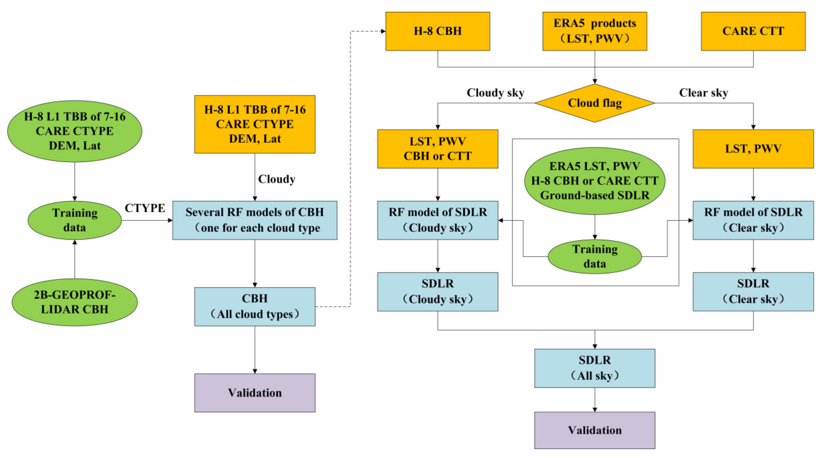
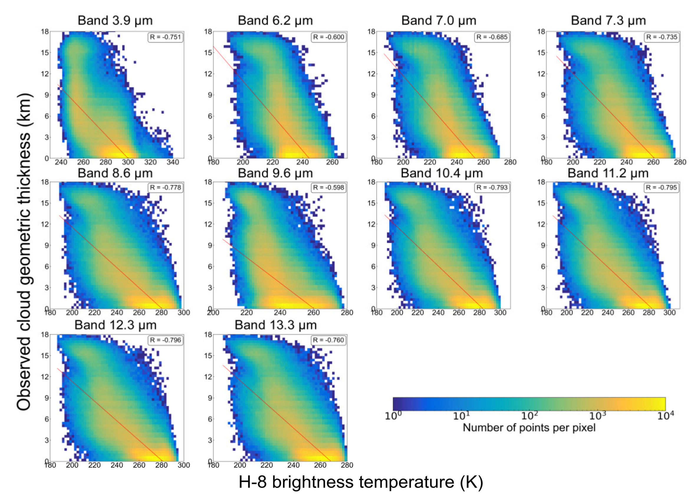
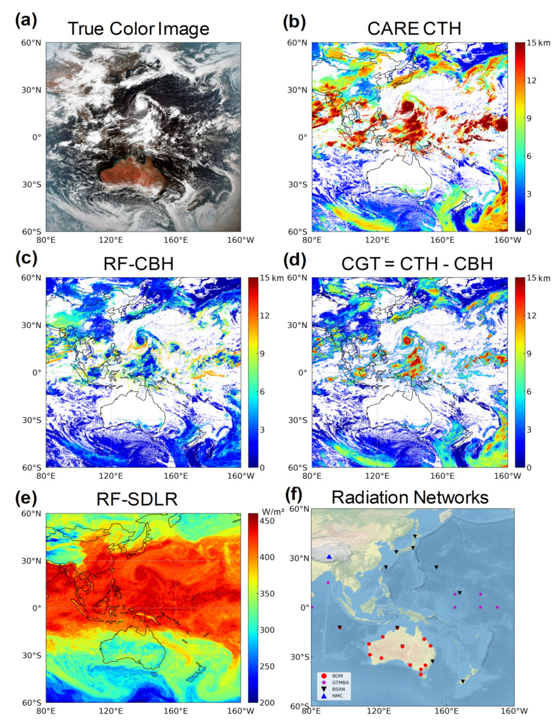
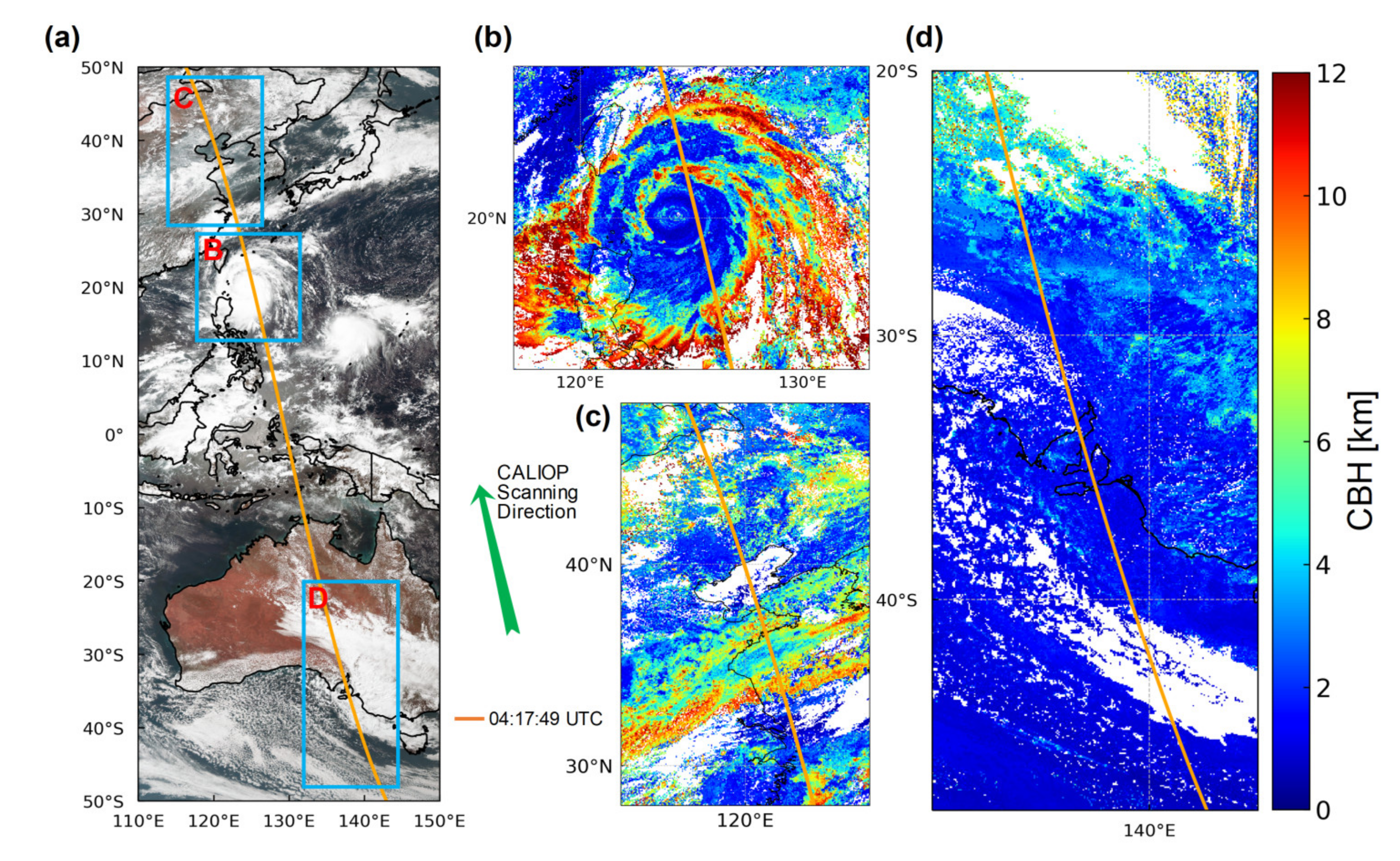

| Channel | Band (μm) | Spatial Resolution (km) | Use or Not | |
|---|---|---|---|---|
| Visible | 1 | 0.46 | 1 | |
| 2 | 0.51 | 1 | ||
| 3 | 0.64 | 0.5 | ||
| Near−Infrared | 4 | 0.86 | 1 | |
| 5 | 1.6 | 2 | ||
| 6 | 2.3 | 2 | ||
| Infrared | 7 | 3.9 | 2 | √ |
| 8 | 6.2 | 2 | √ | |
| 9 | 7.0 | 2 | √ | |
| 10 | 7.3 | 2 | √ | |
| 11 | 8.6 | 2 | √ | |
| 12 | 9.6 | 2 | √ | |
| 13 | 10.4 | 2 | √ | |
| 14 | 11.2 | 2 | √ | |
| 15 | 12.3 | 2 | √ | |
| 16 | 13.3 | 2 | √ |
| Different Groups (Channel Number) | Cloud Base Height (km) | ||
|---|---|---|---|
| RMSE | MBE | R | |
| All IR bands, DEM, Lat, cloud types | 1.17 | −0.02 | 0.92 |
| All IR bands, DEM, Lat | 1.53 | 0.08 | 0.82 |
| All IR bands, DEM | 1.61 | 0.17 | 0.81 |
| All IR bands | 1.63 | 0.21 | 0.80 |
| 8,9,10,11,12,13,14,15,16 | 1.67 | 0.19 | 0.80 |
| 9,10,11,12,13,14,15,16 | 1.67 | 0.18 | 0.79 |
| 10,11,12,13,14,15,16 | 1.69 | 0.16 | 0.79 |
| 11,12,13,14,15,16 | 1.77 | 0.16 | 0.77 |
| 12,13,14,15,16 | 1.82 | 0.17 | 0.75 |
| 13,14,15,16 | 1.88 | 0.13 | 0.73 |
| 14,15,16 | 2.07 | 0.18 | 0.67 |
| 15,16 | 2.96 | 0.29 | 0.35 |
| Cloud Type | RMSE (km) | MBE (km) | R | N |
|---|---|---|---|---|
| Ci | 1.27 | 0.10 | 0.91 | 59,061 |
| Cs | 1.53 | 0.06 | 0.89 | 139,910 |
| Dc | 1.21 | −0.04 | 0.79 | 72,470 |
| Ac | 1.56 | −0.04 | 0.87 | 36,213 |
| As | 1.00 | 0.02 | 0.84 | 129,807 |
| Ns | 0.63 | 0.07 | 0.82 | 59,098 |
| Cu | 1.35 | −0.13 | 0.71 | 118,066 |
| Sc | 1.05 | −0.04 | 0.68 | 286,754 |
| St | 0.47 | −0.01 | 0.75 | 46,163 |
| All types | 1.17 | −0.02 | 0.92 | 947,542 |
| RF(CBH)−SDLR | RF(CTT)−SDLR | ERA5 | CERES | N | ||||||||||
|---|---|---|---|---|---|---|---|---|---|---|---|---|---|---|
| RMSE | MBE | R | RMSE | MBE | R | RMSE | MBE | R | RMSE | MBE | R | |||
| BOM | Clear−sky | 23.6 | −1.1 | 0.88 | 23.6 | −1.1 | 0.88 | 28.9 | −7.7 | 0.85 | 33.8 | −3.5 | 0.77 | 101,775 |
| Cloudy−sky | 19.5 | 0.8 | 0.92 | 26.8 | 2.6 | 0.88 | 25.1 | −7.1 | 0.89 | 28.5 | 0.5 | 0.83 | 30,861 | |
| All−sky | 22.7 | −0.6 | 0.89 | 24.3 | −0.2 | 0.88 | 28.1 | −7.6 | 0.86 | 32.6 | −2.6 | 0.79 | 132,636 | |
| BSRN | Clear−sky | 19.4 | 2.1 | 0.94 | 19.4 | 2.1 | 0.94 | 22.1 | −2.9 | 0.92 | 26.6 | 3.1 | 0.89 | 67,303 |
| Cloudy−sky | 17.0 | −0.8 | 0.97 | 25.2 | 3.7 | 0.95 | 22.2 | −7.7 | 0.95 | 23.6 | −1.5 | 0.93 | 41,257 | |
| All−sky | 18.5 | 1.0 | 0.95 | 21.6 | 2.7 | 0.94 | 22.1 | −4.7 | 0.94 | 25.5 | 1.3 | 0.91 | 108,560 | |
| GTMBA | Clear−sky | 11.5 | 0.9 | 0.82 | 11.5 | 0.9 | 0.82 | 13.0 | −2.6 | 0.79 | 12.0 | −1.4 | 0.80 | 19,850 |
| Cloudy−sky | 9.2 | −0.3 | 0.68 | 12.4 | 0.7 | 0.52 | 12.7 | −6.1 | 0.54 | 12.0 | −5.8 | 0.57 | 9686 | |
| All−sky | 10.8 | 0.5 | 0.84 | 11.8 | 0.8 | 0.82 | 12.9 | −3.8 | 0.80 | 12.0 | −2.8 | 0.81 | 29,536 | |
| NMC | Clear−sky | 31.0 | 1.3 | 0.79 | 31.0 | 1.3 | 0.79 | 43.8 | −32.6 | 0.84 | 40.2 | −17.9 | 0.76 | 11,006 |
| Cloudy−sky | 29.7 | 5.1 | 0.86 | 34.2 | 7.4 | 0.88 | 37.6 | −22.1 | 0.87 | 38.4 | −1.0 | 0.79 | 14,929 | |
| All−sky | 30.2 | 3.5 | 0.83 | 32.8 | 4.8 | 0.85 | 40.3 | −26.5 | 0.86 | 39.2 | −8.1 | 0.77 | 25,935 | |
| All | Clear−sky | 22.5 | 0.9 | 0.93 | 22.5 | 0.9 | 0.93 | 27.1 | −7.2 | 0.92 | 30.5 | −2.2 | 0.89 | 161,160 |
| Cloudy−sky | 20.5 | 0.9 | 0.97 | 25.9 | 3.0 | 0.95 | 26.1 | −10.0 | 0.96 | 28.0 | −1.1 | 0.94 | 85,515 | |
| All−sky | 21.8 | 0.9 | 0.95 | 23.7 | 1.7 | 0.94 | 26.8 | −8.2 | 0.94 | 29.6 | −1.8 | 0.91 | 246,675 | |
Disclaimer/Publisher’s Note: The statements, opinions and data contained in all publications are solely those of the individual author(s) and contributor(s) and not of MDPI and/or the editor(s). MDPI and/or the editor(s) disclaim responsibility for any injury to people or property resulting from any ideas, methods, instructions or products referred to in the content. |
© 2023 by the authors. Licensee MDPI, Basel, Switzerland. This article is an open access article distributed under the terms and conditions of the Creative Commons Attribution (CC BY) license (https://creativecommons.org/licenses/by/4.0/).
Share and Cite
Shao, J.; Letu, H.; Ri, X.; Tana, G.; Wang, T.; Shang, H. Estimation of Surface Downward Longwave Radiation and Cloud Base Height Based on Infrared Multichannel Data of Himawari-8. Atmosphere 2023, 14, 493. https://doi.org/10.3390/atmos14030493
Shao J, Letu H, Ri X, Tana G, Wang T, Shang H. Estimation of Surface Downward Longwave Radiation and Cloud Base Height Based on Infrared Multichannel Data of Himawari-8. Atmosphere. 2023; 14(3):493. https://doi.org/10.3390/atmos14030493
Chicago/Turabian StyleShao, Jiangqi, Husi Letu, Xu Ri, Gegen Tana, Tianxing Wang, and Huazhe Shang. 2023. "Estimation of Surface Downward Longwave Radiation and Cloud Base Height Based on Infrared Multichannel Data of Himawari-8" Atmosphere 14, no. 3: 493. https://doi.org/10.3390/atmos14030493
APA StyleShao, J., Letu, H., Ri, X., Tana, G., Wang, T., & Shang, H. (2023). Estimation of Surface Downward Longwave Radiation and Cloud Base Height Based on Infrared Multichannel Data of Himawari-8. Atmosphere, 14(3), 493. https://doi.org/10.3390/atmos14030493


