Article

Pilot Studies of the Unique Highland Palsa Mire in Western Sayan (Tuva Republic, Russian Federation)

by
Sergey N. Kirpotin
1,2,
Zoia N. Kvasnikova
1,3,
Sophia A. Potapova
3,
Irina I. Volkova
2,4,
Igor V. Volkov
5,
Andrei I. Pyak
1,4,
Arisiya A. Byzaakay
2,
Larisa G. Kolesnichenko
2,
Inna V. Lushchaeva
4,
Aldynay O. Khovalyg
1,
Irina V. Kuzhevskaia
3,
Vladislav V. Chursin
3,6 and
Anna M. Peregon
1,7,*
1
Research Organization Department, Tuvan State University, Lenina Street, 36, 667000 Kyzyl, Russia
2
Bio-Clim-Land Centre of Excellence, Tomsk State University, Lenin Avenue, 36, 634050 Tomsk, Russia
3
Geology and Geography Faculty, Tomsk State University, Lenin Avenue, 36, 634050 Tomsk, Russia
4
Institute of Biology, Ecology, Soil Science, Agriculture and Forestry, Tomsk State University, Lenin Avenue, 36, 634050 Tomsk, Russia
5
Research Center of Natural Science, Tomsk State Pedagogical University, Kiyevskaya Street, 60A, 634061 Tomsk, Russia
6
Scientific Research Center of Space Hydrometeorology «Planeta» (Siberian Center of SRC «Planeta»), Sovetskaya Street, 30, 630099 Novosibirsk, Russia
7
Institute of Soil Science and Agrochemistry, Siberian Branch of the Russian Academy of Sciences (ISSA SB RAS), Pr. Akademika Lavrentyeva, 8/2, 630090 Novosibirsk, Russia
*
Author to whom correspondence should be addressed.
Atmosphere 2022, 13(1), 32; https://doi.org/10.3390/atmos13010032
Submission received: 29 October 2021 / Revised: 14 December 2021 / Accepted: 21 December 2021 / Published: 26 December 2021
(This article belongs to the Special Issue Permafrost Peatlands under Rapid Climate Warming)

Abstract

:
In contrast to the well-studied West Siberian sector of frozen bogs in the Russian Arctic, the frozen mound bogs (so-called “palsas”) on the highlands of Southern Siberia have not yet been studied, but they are suspected to be even more sensitive to ongoing climate change. This article provides the pilot study on palsa mire Kara-Sug in the highland areas of Western Sayan mountain system, Tuva Republic. The study focuses on the current state of palsa mire and surrounding landscapes, providing wide range of ecological characteristics while describing ongoing transformations of natural landscapes under a changing climate. The study used a variety of field and laboratory methods: the integrated landscape-ecological approach, the study of peat deposits, geobotanical analysis, and modern analysis of the chemical composition of water, peat, and soils. The study shows that highland palsa mires are distinguished by their compactness and high variety of cryogenic landforms leading to high floristic and ecosystem diversity compared with lowland palsa mires. This information brings new insights and contributes to a better understanding of extrazonal highland palsa mires, which remain a “white spot” in the global environmental sciences.

1. Introduction

Palsa mire (from Finnish—palsa) is poorly drained lowland underlain by organic sediments, which contains perennially frozen peat bodies: peat plateau or peat mounds [1]. Palsas are caused by permafrost and protrude above the surface of the surrounding peatland. The height of these mounds may vary from about one meter up to several meters and they may be several hundreds of square meters in area, so that the large palsas may form the peat plateau [2,3]. The palsa is the type of mire that occurs in the Northern Hemisphere, and it represents one of the most marginal permafrost features at the outer limit of the permafrost zone [2]. It makes palsa mires extremely sensitive to climate change [2,4,5,6,7,8]. The southern limit for palsa formation in Europe coincides with the 1 °C isotherm of mean annual air temperature [3,5,9]. In Western Siberia, the isotherm for the palsa-type mires varies from 6.9 °C (at the southern limit) up to 7.6 °C (at the northern limit) due to the strong climate continentality [10].
In Russian scientific publications, the term “mound bogs” is conventional for the palsa-type mires. Two types of palsa mires have been defined [1,11,12,13,14,15]: (i) the large mound palsa, with dome-shaped tall mounds 2–5 (7) m height embedded into surrounding fens; and (ii) the flat mound palsa, with vast low plateaux (0.5–1.5 m) surrounded by numerous thermokarst landforms and lakes. In the lowland areas, such as Western Siberia, the large mound palsas occur at the southern limit of mound bogs. They represent the typical landscapes at the southern border of the northern boreal (taiga) region, also propagating to the north of northern taiga region and to the dry river valleys in forest tundra. Basically, the large mound palsa geographical region is located to the south of the flat mound palsa region and it corresponds to 56% (194,000 km2) of the total area in Western Siberia. The flat mound palsa occupy large areas in the north of the northern taiga and in the forest tundra, with certain extent in the southern parts of tundra zone. The flat mound palsa mires correspond to ~8% (240,000 km2) of the total area in Western Siberia [1,8,12].
Extensive studies of natural ecosystems in the cryolithozone in terms of their current state and modern dynamics under conditions of climate change started in the early 2000s. The studies were conducted in the areas of both continuous and discontinuous permafrost in the Alaska Peninsula and in the Northern Eurasia (including its European part, Western Siberia, and Eastern Siberia) [16,17,18,19,20,21,22,23,24,25,26]. A wide range of recent studies have convinced the noticeable and relatively rapid transformations of permafrost mire landforms, leading to dramatic decrease in an areal extent of frozen plateau peatlands and heaving mounds (palsas), as observed in the Northern Eurasia [1,3,7,8,16,27] and in the northern part of North America [28]. Degrading of permafrost in the Arctic and Subarctic peatlands was extensively observed as the result of global climate change [27,29,30,31,32,33].
In Russia, the studies of permafrost and thermokarst processes in mire ecosystems have been implemented since the second half of the 20th century, with a primary focus on the vast flat terrains [1,8,34,35,36,37,38,39]. Evidently, it was found that a fairly large number of frozen mounds in permafrost peatlands were either degraded at some certain extent, or they have been completely destroyed over the past 100 to 200 years, especially those near the southern range of permafrost distribution [39,40]. At the same time, there was clear evidence for the formation and further growth of a number of individual mounds, as driven by local factors, such as migration of river beds, changes in the configuration of lakes, or even such exotic as the activity of beavers, who affect the site and soil hydrology [41]. There was some evidence of the current growth of frozen mounds, as well as on-going increase of their areal extent, both in the southern and northern parts in permafrost regions [42,43].
In the mountain regions, the dynamics and direction of cryogenic (permafrost) processes in the frozen mires are closely related to local environmental conditions, including the meso- and microtopography, the features of lateral flow of mire waters. In addition, the mountain mires strongly depend on climatic conditions: The small areal extent and shallow peat deposits both lead to their vulnerability to hydroclimatic and environmental changes [44].
Nevertheless, the mountain mires, including those in the Altai-Sayan region, have not been well studied up to date, compared to the mires spread over the flat terrains in the northern parts of northern hemisphere. Hereby, we present the first results of the field studies of the current state and on-going transformations of the unique palsa-type mire ecosystems (and a wide range of surrounding natural landscapes) in the south of the geographical region of Middle Siberia (a part of Central Asia), the first ever accomplished in the Russian Sayan Mountains in the Tuva Republic, Russian Federation.

2. Materials and Methods

2.1. Study Region and Sites

The study site is located in the Barun-Khemchik administrative region of the Tuva Republic in the basin of the Ak-Sug river at the Alash highlands of the southern flank of the Western Sayan mountain range of the Altai-Sayan mountainous region (Figure 1).
The Alash Highland is a rocky plain (plateau) with separate alpine peaks, dissected by deep valleys of the Alash and Ak-Sug rivers. The absolute heights of the highlands in the Ak-Sug river basin vary from 1120 to 3122 m asl. The study site is located in the mid-high mountain belt [45].
In general, a strong continental climate is common in Tuva. The complex topography of the region is a main driver of variable high-altitude zonal climatic conditions. The climate of the study site is typical climate of the Central Tuva steppe regions and the middle mountain taiga regions of the Western Sayan; it differs from sharp continental climate of the central Tuva [46]. The Alash Highlands are located in the rain shadow of the Western Sayan and Altai mountains, so annual precipitation in low mountain regions is no more than 300 mm, but it can be in a range of 500–1000 mm in higher mountains and on windward slopes. The winter is cold with shallow snow depth, and frequently invaded by anticyclone systems. The multi-year average temperature in the middle of 20th century was at the range of −7 to −5 °С, with the average temperature in July of +18 °С, and that in January of −33 °С with frequent events of temperature inversions [47,48]. The annual amplitude of air temperature exceeds 50 °С, and the diurnal amplitudes exceed 25 °С (especially in March). A special feature of the local climate is the fast cross of the average daily air temperature over 0 °C.
According to (common in Russian science system of) soil-geographical division, the study site is considered as part of the sub-boreal region (Tuva-South-Transbaikalian soil province) [49].
The Alash Highlands belongs to the alpine and subalpine belts of continuous and discontinuous permafrost [50]. The presence of permafrost and seasonal frost in different landscapes of Tuva determines the development of cryogenic processes. The permafrost phenomena occur at the flat watershed terrains, same on the slopes of high mountains, where it forms the mountain terraces, stone rivers, cryogenic landforms, and landforms elaborated by solifluction. Alpine-type topography, with wide-spread nival and erosion/denudation processes, are the cause of avalanches, landslides, bottom erosion, and mudflows. Frost cracks, heaving mounds, ice mounds and thermokarst subsidence are widely developed in the river valleys and at flat areas of low mountains.
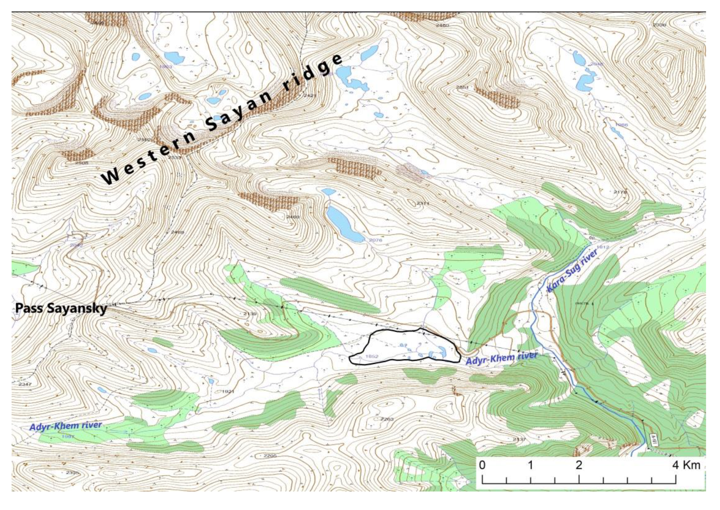
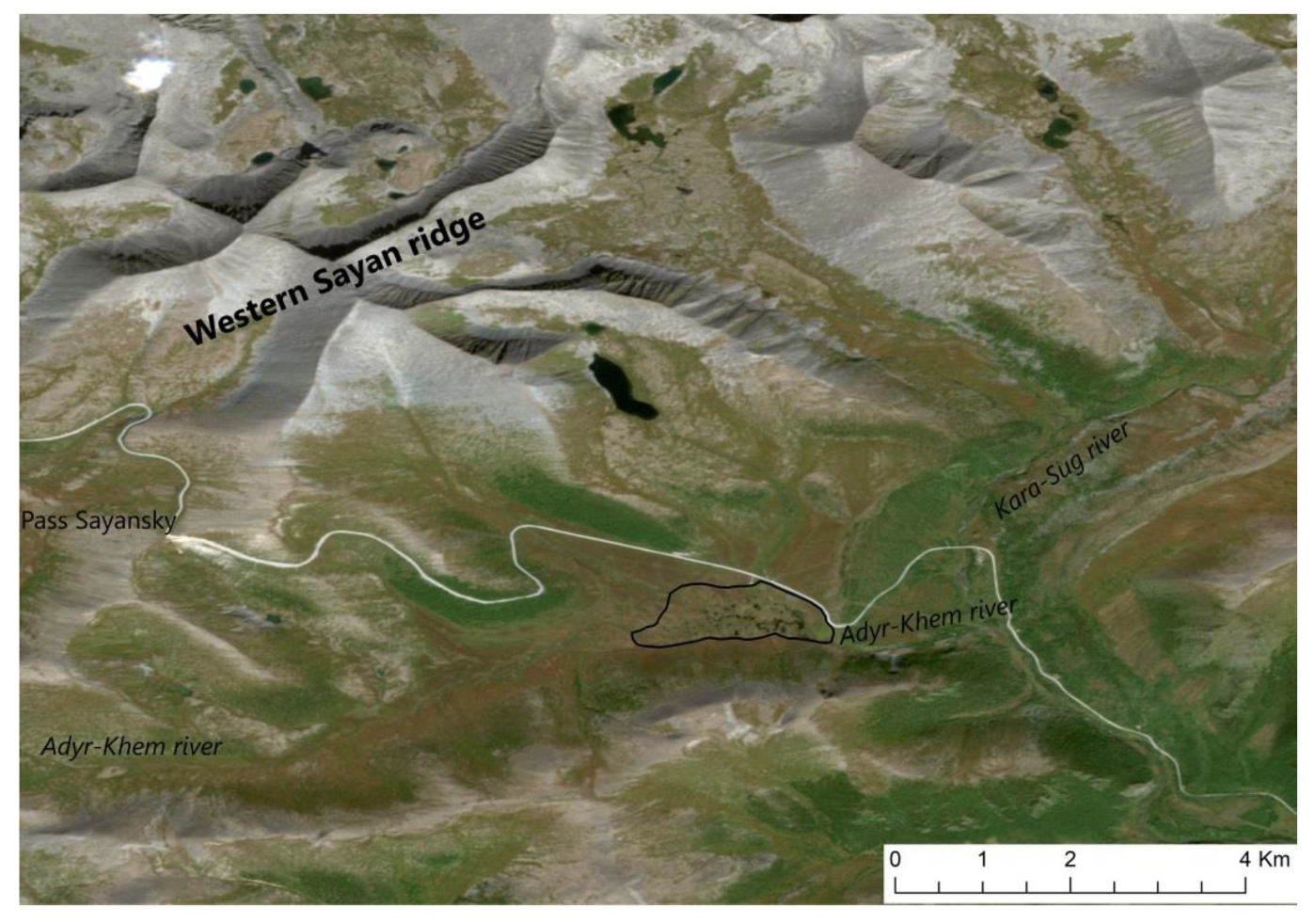
Our observations in Adyr-Khem river valley, the right tributary of the Kara-Sug river (Ak-Sug river basin) in the northwestern part of the Alash Highlands (Figure 2), have revealed the presence of frost heaving mounds (palsa) mires, possibly the result of both cryogenic heaving and thermokarst processes.

2.2. Study Methods in the Field

The field research adopted an integrated landscape-ecological approach. This includes the studies of wetland/peatland topography, hydrological regime at wetland sites, floristic diversity, vegetation/land cover and spatial heterogeneity of natural landscapes, the structure of soil cover, and stratigraphy of peat sediments [44].
At the study site, the test plots were chosen for further in situ studies based on available geographical maps, the data of satellite imagery, and other cartographical materials, as well as chosen in the field based on an expert assessments at the most representative ecosystems. The field studies included: cleaning the walls of heaving frozen mounds, description of soil profiles, taking the photos, sampling of water, soil, and ice, geobotanical descriptions, sampling of plants for taxonomical identification, taking peat samples from the cores with Russian peat corer, and taking the probes to figure out actual distribution of permafrost over the wetland site (with Russian peat corer; about 100 probes).
The vegetation of the Alash plateau was formed under the influence of two main factors: (i) its location on the ways of ancient migration of plant species and (ii) altitudinal zonality. As a result, the flora of the region is mainly presented by widespread boreal elements with some endemic upland species. This kind of heterogeneity is the evidence for common genesis of all those landscapes as a part of the old trans-Asian mountain system [51]. The land cover of the Alash plateau comprises the elements of steppe, forest and alpine-type vegetation presented at different altitudes in the mountain regions. The forest formations presented by larch (Larix sibirica), cedar (Pinus sibirica), spruce (Picea obovata), fir (Abies sibirica), birch species (Betula pendula, Betula microphylla), aspen (Populus tremula), and field laurel (Populus laurifolia). The steppe formations presented by wormwood-grass and forb-feather grass communities, but large areas presented by rocky outcrops and placers.
The vegetation survey in the field was conducted using plot-based method according to Mueller–Dombois and Ellenberg [52] and Kuznetsov [53]. For each plot, the note of geolocation recorded by GPS. Geobotanical descriptions (relevés) were made at each type of habitat and separately for the various elements of mire complex (for example, hummock/hollow or mound/lake). The relevés were taken from square plots the size of 4 to 100 m2 depending on the type of plant community: Moss-dominated micro-landscapes required some smaller plots than that of shrub-dominated micro-landscapes. The species’ cover/abundance visual estimation, further analysis of the relevés, and preliminary ordination of plant communities and the vegetation classification followed the Braun-Blanquet methodology [54].
An integrated approach was applied for the study of thermokarst lakes and the Adyr-Khem river, which originates from palsa mire. In situ measurement and water sampling were carried out in October 2020. Dissolved oxygen, pH, electrical conductivity, and temperature profiles were measured in situ using a WTW Multi 3320 multimeter with data loggers: Cell Ox 325 (0 to 50 mg/L, ±0.1 mg/L), pH-Electrode Sen Tix 41 (−2.0 to 19.9 pH; ±0.03 pH), and WTW Tetra Con 325 (0.0 µS·cm−1 to 1 S·cm−1, ±1 μS/sm, and 0 to 90 °C; ±0.1 °С). Measurements of CO2 dissolved in stream waters and open water bodies were carried out using a data recorder with underwater sensor GM70, Vaisala® (0 to 3000 ppm; ±0.1 ppm). For microbiological studies, the samples of water were collected in sterile containers.
In this pilot study, we analyzed the data collected at four water bodies: the Ak-Sug river (the left tributary of Khemchik river), the Adyr-Khem river originated from the palsa mire (Figure 2), and two thermokarst lakes on palsa mire (Table 1).

2.3. Laboratory Analysis

The macrofossil analysis of peat sediments and the study of soil profiles (physics and chemistry of the grounds, including the loss on ignition (LOI)) were performed in the laboratory according to international standard protocols [55].
The list of the plant species resulting from all the relevés was used to analyze the taxonomical structure of the flora. New findings of the plant species were checked according to previous studies; for example, see in [44]. In total, 130 samples of bryophytes and lichens were collected and identified. The collection is kept at the Tomsk State University, Russia. The names and nomenclature of species and other taxa for vascular plants are given according to Tcherepanov [56], for mosses—according to the “Check-list of mosses of East Europe and North Asia” [57]; for liverworts—according to the “Liverworts and hornworts of Russia” by Potemkin and Sofronova [58].
The chemical analysis of soils (Na2O, MgO, Al2O3, SiO2, P2O5, K2O, СaO, TiO2, MnO, Fe2O3) was carried out in a certified laboratory of the Analytical Center for Shared Use of Geochemistry of Natural Systems of Tomsk State University using quantitative X-ray fluorescence analysis on a device X-ray fluorescence energy dispersive spectrometer Oxford ED-2000 (analyzed elements: from Na (11) to U (92); number of analyzed elements: up to 75 elements in one set; the size of the analyzed sample from 0.2 to 200 mm in diameter (up to 85 mm high); accuracy in the concentration range 102…100%—no more than 5%; in the concentration range 3 × 10⁴…100%—no more than 1%).
Estimation of total number of bacteria accomplished by staining preparations made from a soil suspension with a fluorescent two-component dye L7012 (LIVE/DEAD BacLight bacterial viability kit®) in accordance with standard manufacturer’s protocols. Further, the total number of bacteria counting was made according to standard manufacturer’s protocol using a luminescent microscope, Zeiss Axio Imager Z2.
Interpretation of satellite imagery (Sentinel-2b, 10 m/pix resolution) along with images obtained with a drone Autel Evo ii 6k pr implemented to investigate the current state of natural ecosystems and to create the map of open water bodies. In addition, the data from free map services (Google Maps and Yandex Maps), and a set of topographic maps (1:50,000 and 1:100,000 scales), as well as numerous pictures taken during field trips in 2020 and 2021 were used as Appendix A. Landscape classifications (and land-cover maps) were created using the fully functional ArcGIS 10.3 software package; MS Excel software packages were used for processing materials.

3. Results

3.1. Landscapes and Ecological Characteristics of Study Area

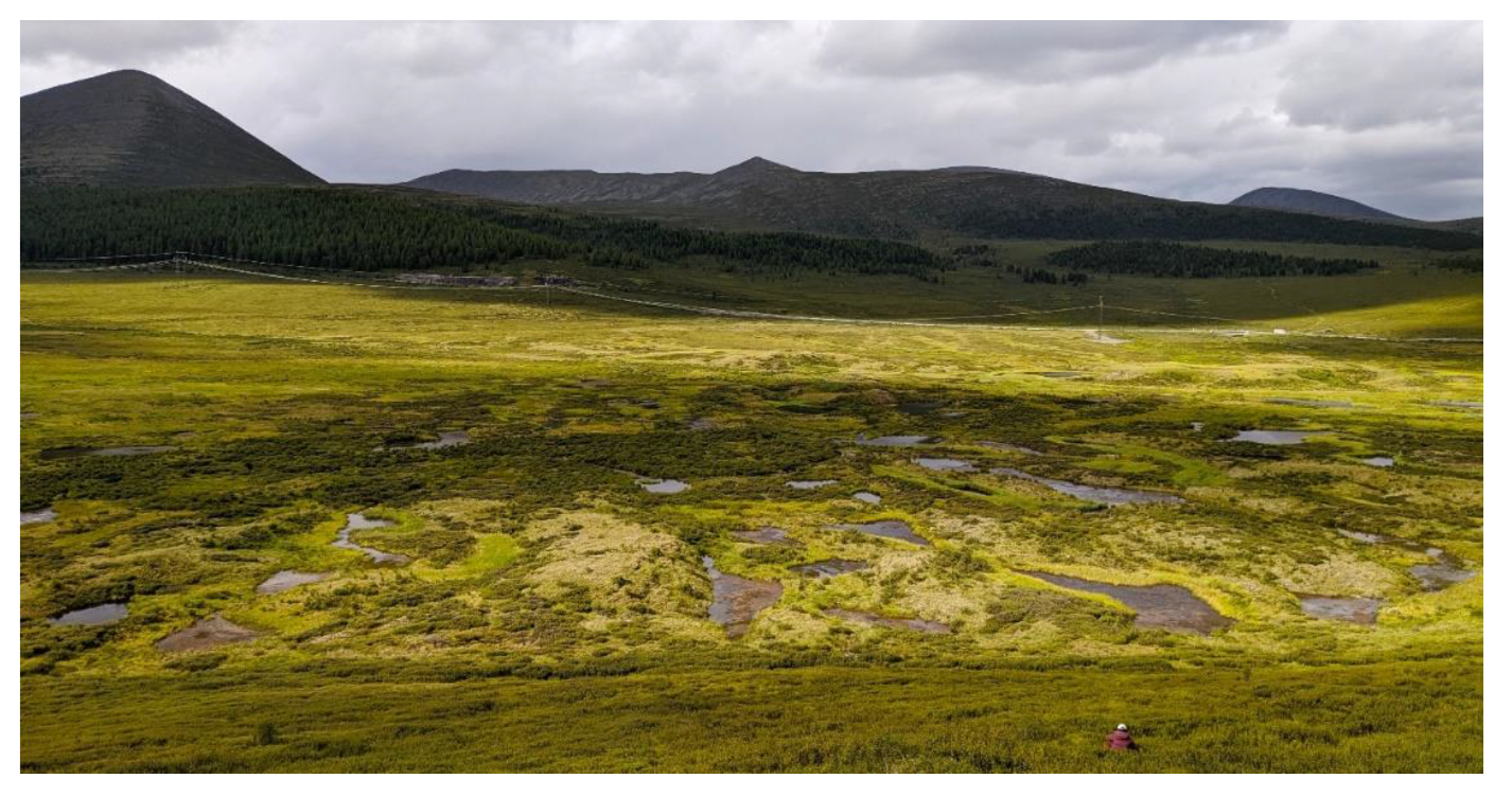
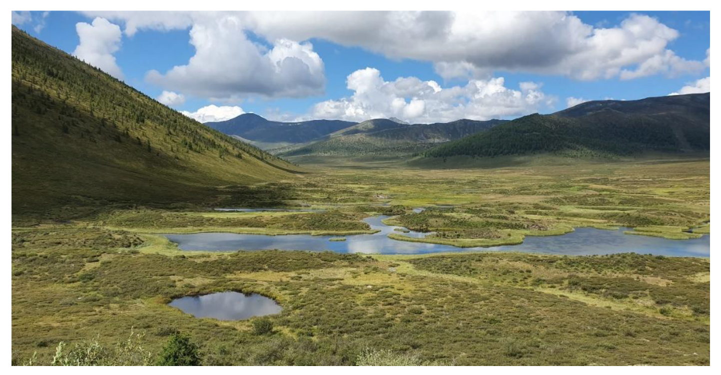
The key site in Adyr-Khem river valley is a wetland site (Figure 3). Spread in line from west to east, it is represented by elevated and depressed topographical features. The elevations are 1800–1820 m asl. The meandering course of Adyr-Khem river with a large number of lakes indicates the valley underlying the sediments of different origins: loam, sandy loam, pebble, and crushed stone.
Fine fractions of sediments were formed in lake basins and at river valleys with low rates of water flow, which could provide favorable conditions for the processes of heaving in river floodplains during the period of perennial freezing [59].
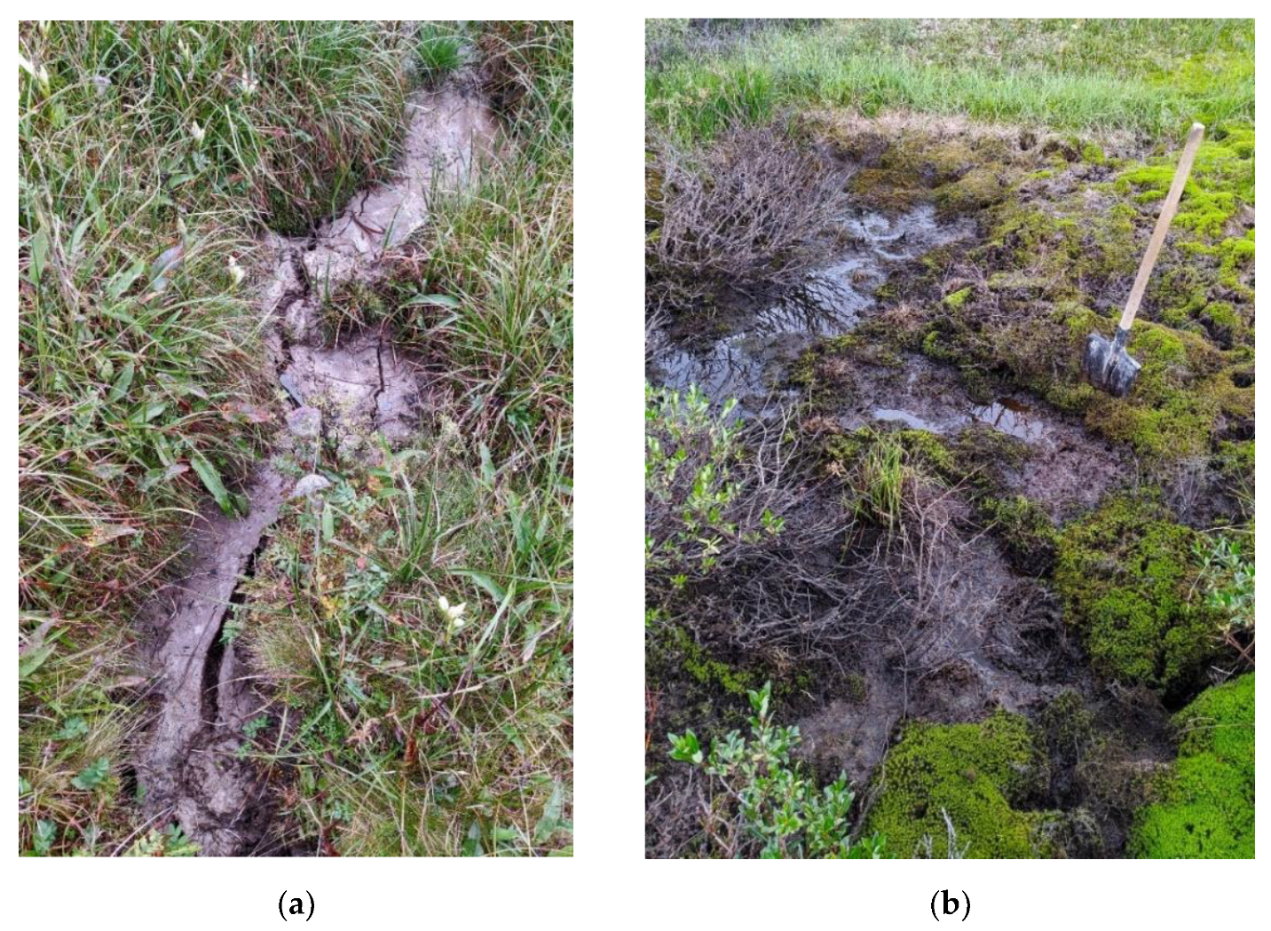
The flat mounds alternating with local depressions, i.e., hollows, lacustrine depressions, and meanders, are the main micro-landscapes in the Adyr-Khem river basin. The tops of the mounds rise above the surrounding flat wetlands to the height of 1.5 to 10 m. The majority of mounds have an oval-elongated shape; but some of them have a horseshoe-like shape. The slopes of the mounds range from gentle to steep; the last drops to the stream bed. The active development of thermokarst processes is the main driver in creation of numerous cracks and micro-depressions on the surface of frozen mounds (Figure 4a,b). The depth of cracks ranges from 10–15 to 60 cm; the width of the cracks varies from 10 to 50 cm. On the slopes of large mounds, the cracks in several rows represent a complex micro-topography.
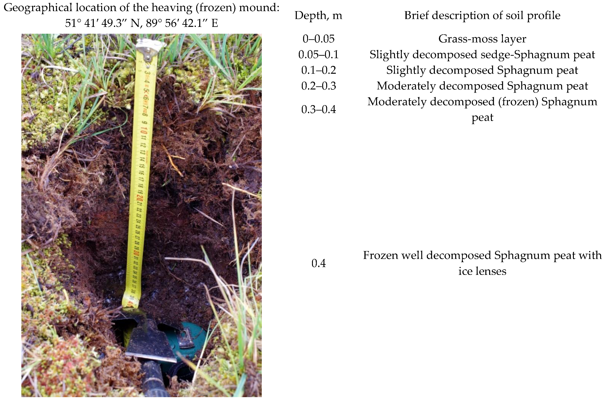
One frozen mound located in the eastern part of the study site has the dimensions of 20 × 40 m and the high of 1.5–2.0 m. A detailed description of the soil profile at this test plot presented in Figure 5.
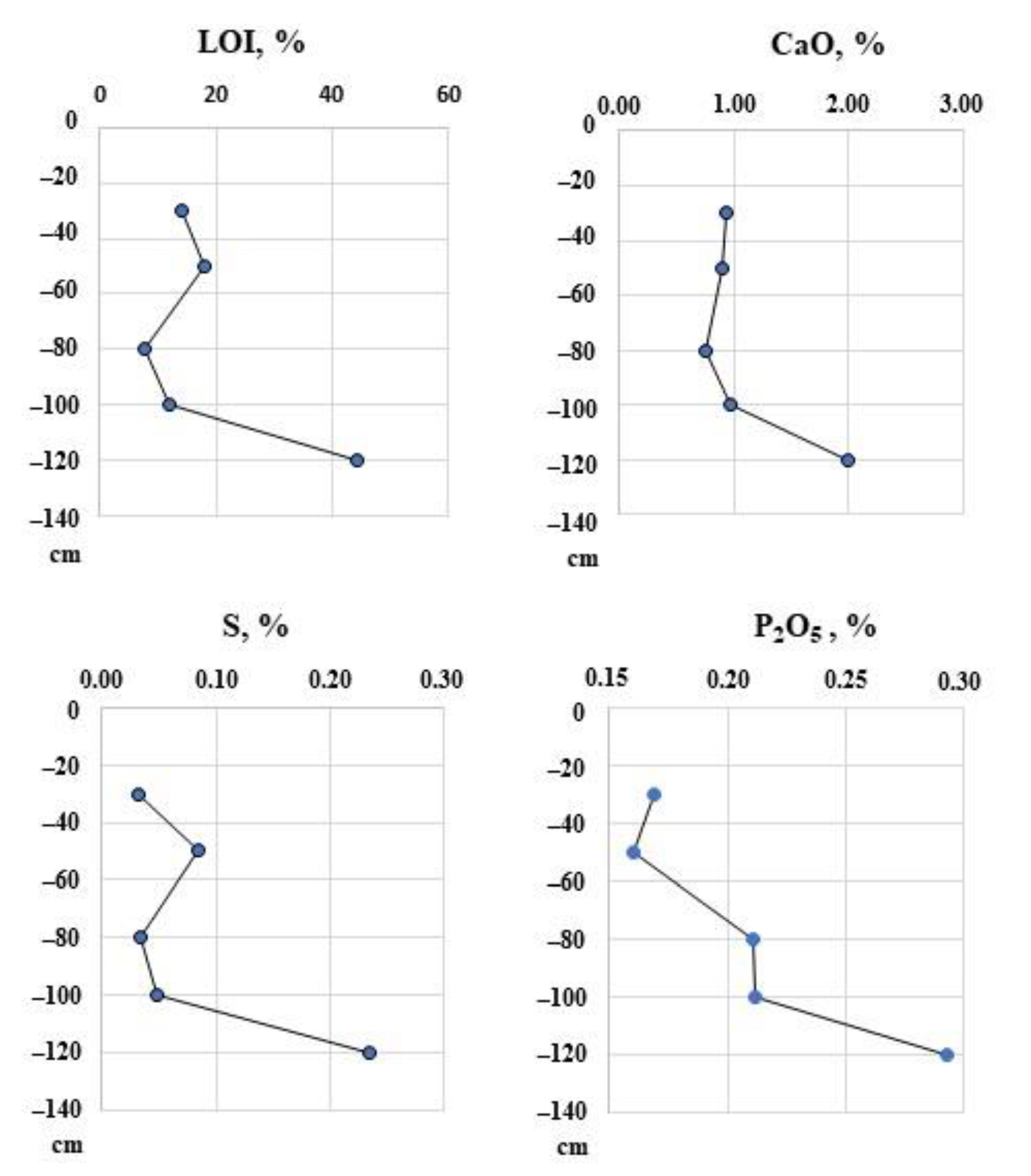
The value of the loss on ignition (LOI) and the concentration of macro-elements are shown in Figure 6. In the middle depth of the soil profile, the lowest LOI values were observed due to presence of rubble. Then, there was a slight increase in the LOI to the upper and lower layers of soil profile; and a dramatic increase by about 5.5 times at a depth of 1.2 m. The same trend was observed in the content of CaO, S, and P2O5.
At all test plots set up in this study, the layers of peat (20 to 50 cm of thickness) with different rates of decomposition were observed. The frozen grounds (permafrost) were found at the depth of 31 to 135 cm.
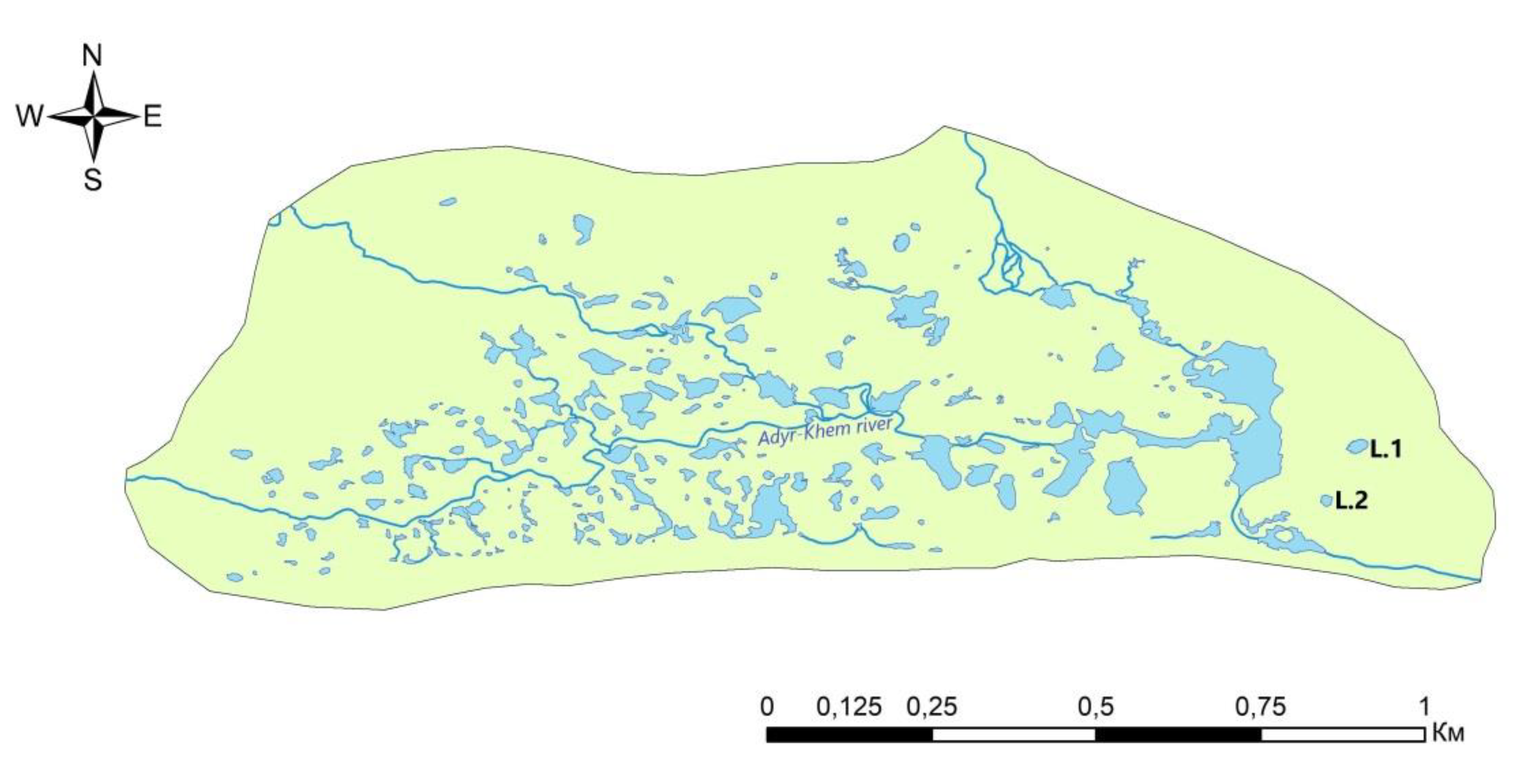
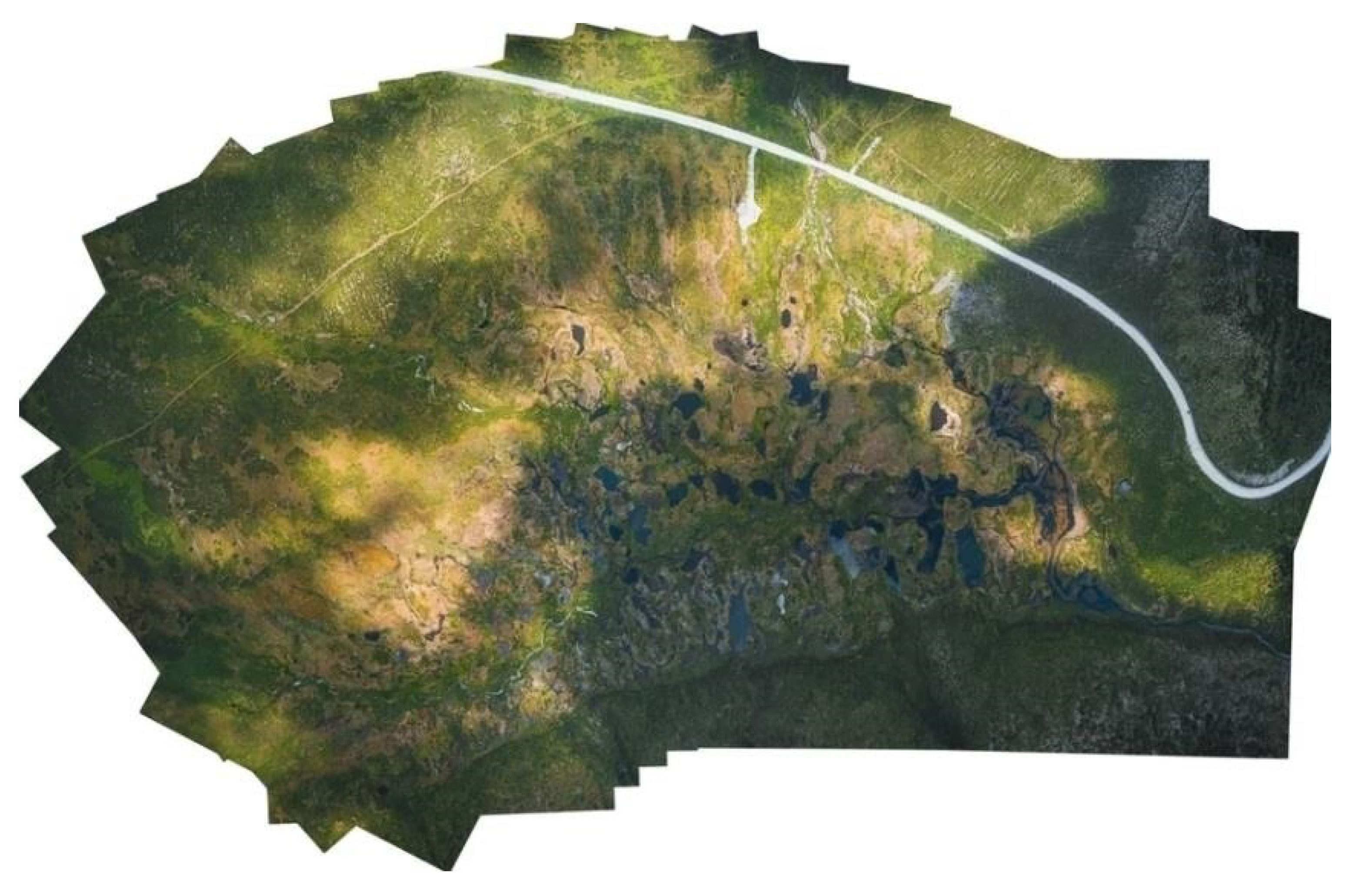
The satellite data revealed about 200 lakes within the study site (Figure 7); the largest lakes presented on the diagram (Figure 7). The total area of the open water bodies within the study site accounted for 63,400 thousand m2. Basically, the majority of lakes are small in size, except those 12 with the area exceed 10 m2. Many lakes are connected with the Adyr-Khem river. Most of the lakes have a rounded, oval-elongated and lobed shape, with lake shores. The largest lake is located in the eastern part of the study site (Figure 7; center part of Figure 8; and Figure 9). Its water surface accounted for 15.9 thousand m2, and the length of the shoreline is 1.3 thousand meters. The basin of this lake differs from other lakes by specific (rounded-blade-elongated) shape, which we suspect could be resulted from thermokarst processes, but also detachment of the Adyr-Khem meander draining the valley.

3.2. Vegetation at the Key Site

The vegetation at the Adyr-Khem study site is rather complex, mainly affected by regional topography, the presence of permafrost, floodplain erosion, and alluviation, as well as climatic factors. In turn, the location of study site at the flat bottom of intermountain depression determines large constrains of temperature inversions, which, along with topography, are the main factors of complexity observed in land cover and diversity of vegetation (Figure 10).
The vegetation is mainly presented by shrubs spread in floodplains, as well as cryophilic steppe meadows and open mires. Floodplain meadows are sparse and small in the area; they represent pioneer vegetation.
Shrub vegetation is dominated by round-leaved birch (Betula rotundifolia)—dwarf birch formations (so-called “yernik”) in the mountains of South Siberia. The shrubs (Betula fruticosa, Dasiphora fruticosa, Lonicera altaica, Salix glauca, Spiraea alpina) and various herbaceous plants contribute to the list of plant species in yerniks. This type of vegetation community is the most widespread in the region. It could be presented on the mineral- and peat-heaving mounds, as in the floodplains. The diversity is assured by grass-shrub, moss-shrub, lichen-shrub, and shrub swamp plant communities under the category of bushes.
Cryophilic steppe meadows resemble the same type of vegetation in high altitudes with the main dominants as follows: Bistorta officinalis, Bistorta vivipara, Schulzia crinita, Gentiana algida, Festuca kryloviana, Kobresia myosuroides, Pachypleurum alpinum, and others. The presence of typical alpine species Dryas oxyodonta, Viola altaica, Thalictrum alpinum, Saxifraga sibirica, Salix berberifolia, Sajanella monstrosa let us consider this vegetation under the category of highlands. Bryophytes also correspond to highlands—they are presented by typical species of mountain tundra and rocky substrates: Racomitrium canescens, Aulacomnium turgidum, Polytrichum strictum. Basically, this vegetation occurs on relatively dry, lined surfaces, and on mineral heaving mounds (lithic palsa).
The frozen mires were of great interest in this study, in terms of understanding of their dynamics under the pressure of climate change.
The large areas of the Adyr-Khem study site consist of mires on shallow peat deposits (Figure 11). According to the geomorphological classification of mountain mires [60], these sites refer to the “valley mires”. The mire sites vary from minerotrophic (rich fen) to meso-oligotrophic (bog) mires.
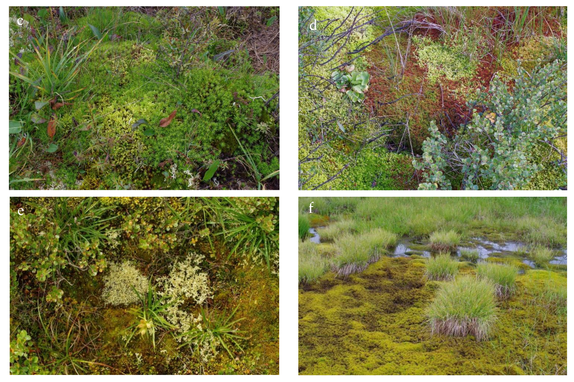
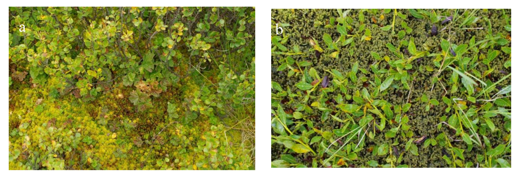
The study site presented by complex mire landscape via compound mosaic of plant communities with a few levels of patterns. The elevated micro-landscapes presented by frozen mounds with dwarf shrub-moss plant communities (Figure 12a). Dwarf birch (Betula rotundifolia) with some separate willows makes a dense cover of shrubs over the mounds. The cover of grasses (Carex altaica, Kobresia myosuroides) could be either large or small, but they normally contribute no more than 10%, although the bryophytes have the capacity to cover a whole land surface (Figure 12b–d). The main dominants of Sphagnum mosses are: S. russowii, S. angustifolium, S. rubellum; and green mosses: Aulacomnium palustre, A. turgidum, Polytrichum strictum, P. commune, Tomenthypnum nitens, species of Hylocomium and Dicranum. The surface of 50-cm height mounds dominated by dwarf birch-moss communities looks like it was formed by micro-hummocks of mosses of one species but with different heights. Thus, mosses often form a small, but well-defined mosaic of spots (4–5 cm in diameter).
The permafrost layers in frozen mounds are located at various depths (normally, at 30–40 cm) within the study site, and they are reflected in the type of vegetation community.
The land surfaces degraded with permafrost formations (turned-over turf, micro-cavity) have been quickly taken by green mosses (Paludella squarrosa, Calliergon) and liverworts (Scapania and Lophozia). In addition, the lichens often settle on the frozen mounds, right over the turf of green mosses (Polytrichum and Dicranum) (Figure 12e). The settlement of green mosses and lichens is clear evidence of slowdown and interruption of peat accumulation, reflecting the sites of mire degradation through the formation of so-called “regressive mire complex” [61]. This kind of degradation is not due to decrease in the moisture content on-top of the mire system, as it is usually the case at a certain stage of developments of raised bogs in the lowland Western Siberia, but the result of permafrost degradation, thermokarst, cryoturbation, and exposure of the peat surface.
The wetland-type (mire) land surfaces dominated by green mosses (Drepanocladus, Warnstorfia, and Calliergon) take place in between frozen mounds with dwarf shrub-moss communities. The same communities dominated by green mosses occupy the hollows and swamps in the runoff troughs (Figure 12f).
Dwarf birch-Sphagnum ridges with a sparse and low cover of cloudberries (Rubus chamaemorus) (Figure 13a) occupy small area plots on the periphery of the Adyr-Khem key site. They are formed by a continuous carpet of Sphagnum russowii and S. angustifolium, with sporadically distributed curtains (diameter of 30–40 cm) made by Polytrichum strictum, and with small patterns of Arcto-Alpine moss species Dicranum angustum. The expansion of lichens has already begun on the spots of Polytrichum.
The flat topographical units (carpets) are often made by Paludella squarrosa, with a small fraction of green mosses (Meesia triquetra) and liverwort (Mylia anomala), sometimes with Sphagnum mosses on the periphery of plant community, contributed by the surrounding dwarf birch-moss mounds. Carex altaica, in low abundance, is a very common herb. On one site in the community, the small creeping willow (Salix rectijulis) makes up to 50% of land cover (Figure 13b).
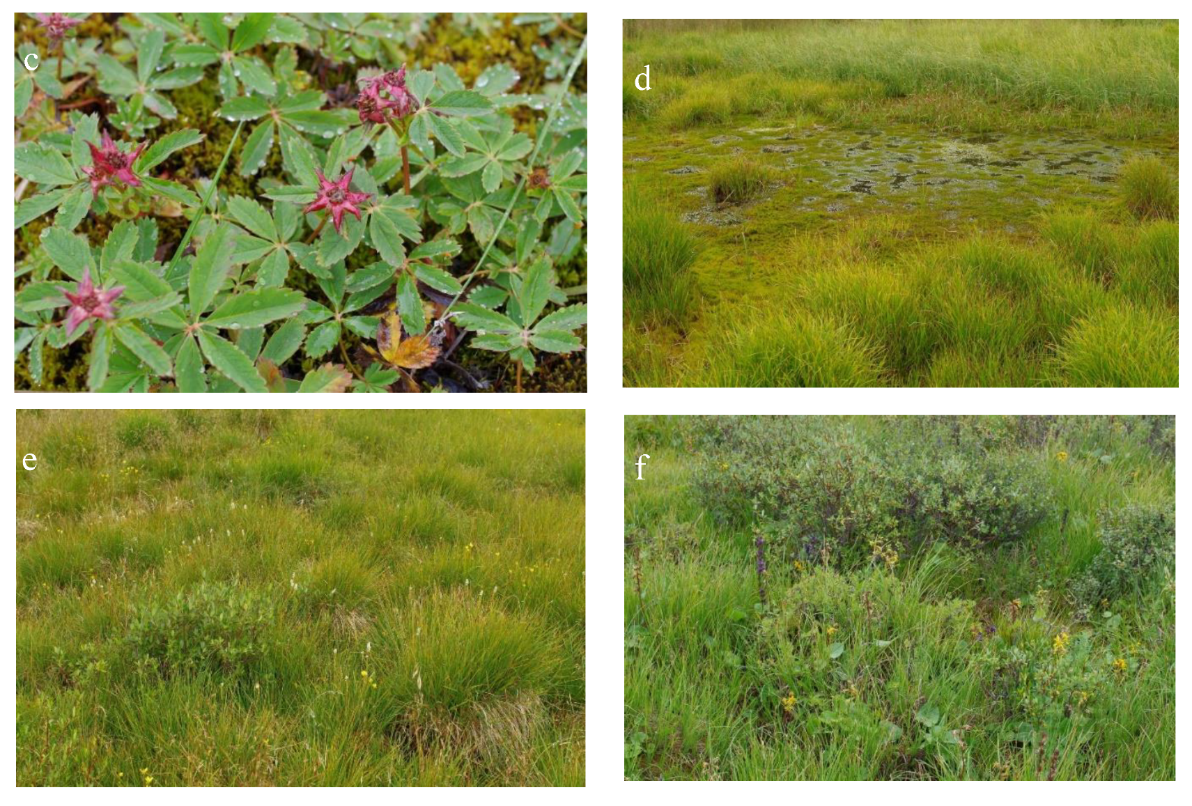
We marked an area within the key site, where in small hollows a community was formed with the domination of marsh cinquefoil (Comarum palustre) and Dicranum (Figure 13c), which make a fairly dense land cover: up to 80%, and up to 100%, respectively. Sometimes, the sedge Carex altaica co-dominates cinquefoil (Comarum palustre) in this plant community, and the rest contributed by cotton grass (Eriophorum polystachyon) and sedge (Сarex canescens). Another version of this community is dominated by Carex altaica and marsh cinquefoil (Comarum palustre) with Sphagnum species in the dense land-cover, found nearby the two described above.
The deep hollows with stagnant water are made of cotton grass, which forms the tussocks on the Warnstorfia carpet (Figure 13d). Paludella squarrosa is a dominant of the moss layer of the floating mats.
The tussocks made by Deschampsia cespitosa with a diameter of 20–30 cm and the height of 20 cm are the main topographical features of the fen (Figure 13e). The shrub layer is not presented; the Salix and Pentafilloides fruticosa make less than 5% of land cover, but there is a dense layer of grasses that contribute to land-cover of about 95%. Deschampsia is the main dominant species in the grass layer, complemented by Swertia, Bistorta vivipara, Cardamine species, and Carex altaica. The micro-depressions are inhabited by Saxifraga hirculis. The moss cover is developed both in the micro-depressions (Paludella squarrosa and Aulacomnium palustre) and on elevated micro-topographical units, or hummocks (Sphagnum russowii).
The tussocks made of Carex canescens; the plain moss carpet consists of Calliergon stramineum and Aulacomnium palustre in same abundance, and with a minor fraction of other green and Sphagnum mosses.
The shores of numerous lakes at Adyr-Khem key site made of sedge (Carex rostrata), often with contribution of cotton grass (Eriophorum polystachyon).
Shrub willow–herb–green moss plant communities (Figure 13f) occupy large areas of the key site. The willow plants (Salix glauca), about 40-cm in height, grow in dense clumps, alternating with dwarf birch curtains and Pentaphylloides fruticosa. The micro-topography presented by numerous hummocks (30-cm-high and 70 cm in diameter) of irregular shape, with presence of thermokarst subsidence of the soil. In contrast to above-mentioned dwarf birch communities on the frozen peat mounds with high diversity of mosses and lichens, the willow bushes on shallow peat soils with mineral horizons are easy of access to plant roots represent the communities with high diversity of vascular plants. Some rare plants included into the Red Book, such as Rhodiola rosea, have been presented. The common herbaceous species in the willow bushes are: Bistorta vivipara, B. officinalis, Ligularia sibirica, Swertia obtusa, all are in small abundance, while the sedge Carex altaica is an absolute dominant species. All together, the herbs make about 75% of the projective land cover, but moss layer is rather sparse and composed of both the species common in the mires (Sphagnum russowii, Aulacomnium palustre, Calliergon stramineum) and in the forest (Mnium rugicum, Polytrichum strictum, P. commune). All of them have very low abundancy. The forest moss (Sanionia uncinata) and mire herbaceous plants (Eriophorum polystachyon and Saxifraga hirculis) settled in small thermokarst subsidences at the mounds.
A whole list of species contributed to floristic diversity of ecosystems at Adyr Chem highland palsa mire sites (I) as well as relative richness of plant species in the most typical plant communities (II) presented in Appendix A Table A1.

3.3. Water Bodies at the Key Site

The results of physicochemical and microbiological analysis of lake and river waters in Tuva compared to natural water bodies of thermokarst lakes in Western Siberia are presented in Table 2.
In all studied water bodies, the pH was alkaline. The pH values ranged from 8.0 to 8.5, with the maximum value found in the waters of the smallest lake formed with thermokarst, which was also found to have a minimum electrical conductivity. In all other water bodies, the electrical conductivity was found at low values. The waters are ultra-fresh, while the waters in rivers have been more mineralized than that of the waters in thermokarst lakes. Somewhat high pH values were previously documented for thermokarst lakes in Altai region [22], but the waters in thermokarst lakes at the flat plains (non-mountain regions) in Western Siberia, were found to have fairly high acidity.
The waters are saturated with oxygen (the concentrations varied from 84.4 to 97.6%), which in general represent typical values for thermokarst lakes in mountain regions [22]. Consequently, the waters in Tuva region contain some low values of CO2. The lowest values (169.0 and 521.5 µmol·L−1) were found in the waters of thermokarst lakes; these values have been somewhat higher than that in the waters of thermokarst lakes in Western Siberia [62]. Moreover, the value of CO2 in the smallest lake with the largest total number of bacteria is much higher. Overall, the gas composition is normally dependent on the area of thermokarst lakes [62]. The highest values of CO2 were found in the waters of small river Adyr-Khem, and that could be resulted from accumulation of runoff from the entire wetland region.

3.4. Climatology and Thermal Regime over the Region

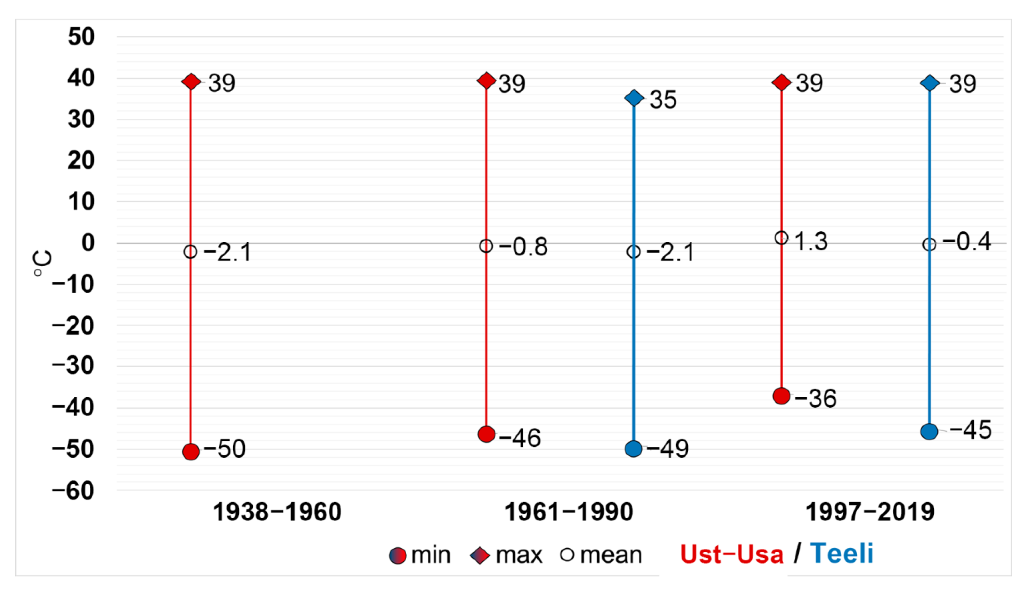
There is no permanent meteorological station operating in the Alash Highlands; thus, we used the data from a number of nearby stations for the period of 1938–2019 (Figure 14). The data from meteorological stations in Tuva and Krasnoyarsk indicate an increase of the average annual temperature and an increase in the amount of precipitation, especially during the warm season [45,63,64]. Teeli and Ust-Usa stations are not included in the list of mandatory meteorological data exchange, therefore, some part of the time series is difficult to access. For the analysis of climatic parameters, archival reference data on the climate of 1967, 1992 (printed editions) and the data at daily resolution for stations were used, which are stored in the Territorial Administration for Hydrometeorology and Environmental Monitoring (Roshydromet Regional Branch).
In accordance with the WMO methodological recommendations [65], three time intervals were analyzed for the data of Ust-Usa meteorological station (1938–1960; 1961–1990; and 1991–2019) and the last two time intervals were analyzed for Teeli meteorological stations (operated since 1960).
The data obtained for the referenced time periods reveals the trend in both the mean annual air temperature and the minimum air temperature. Namely, when one comparing the two time periods, the average annual temperature recorded at all stations increased by 1.7–2.1 °C; and especially, for Ust-Usa station, the temperature increase was found +3.4 °C for all time periods. Thus, it can be concluded that the change in thermal parameters within the study area coincides with both regional trend of climate and global warming.
The thermal regime is formed under the influence of climatic factors at different scales. The local conditions (topography, exposition of slopes, the features of vegetation/land cover, and others) also play an important role in the formation of local climate in the Alash Highlands.
An increase in annual surface air temperature by another 20% with the reference to the calculated periods is expected by the year of 2029 for the Altai and Sayan Highlands. According to this forecast, the annual air temperature by the reference year 2029 will be about −1.99–1.00 °С over the region of Alash Highlands [66].

4. Discussion

4.1. The Features of Paludification and Palsa Mire Formations in the Mountain Regions

One important environmental driver of mire formation in mountain regions is temperature inversions, which is very common condition in intermontane depressions or basins. The temperature inversions cause appearance of so-called reverse altitudinal (or elevational) zonation: The bottoms of the basins are made by tundra-type vegetation communities, while forest-type communities are widely presented at the higher positions of the slope, where they form so-called “forest belt” (Figure 10). The forest belt normally has two thermal boundaries—one is “classic” upper boundary—forest line, and another is the “lower” boundary originated from cold air moving to the bottom of the mountain basin. Besides, the temperature inversion causes freezing of uppermost soil horizons, so that these become watertight horizons. Along with low temperatures, which reduce evaporation from soil surface, this watertight horizon contributes to paludification and further mire formations.
Because of short growing season and severe climate, as well as low productivity of plant communities, the accumulation of peat in mountain mires is relatively slow [67,68] (Figure 11), though even shallow peat deposits prevent permafrost thawing and free water movement. On the other hand, the process of moisture accumulation can be a trigger for the development of permafrost heaving processes. The water penetrates through shallow peat deposits and accumulates in underlying mineral soil horizons. As a result, in cold conditions, ice lenses are formed, which lead to soil swelling and the “litho-palsa” (synonyms: lithic palsa, lithalsa) mound appearing.
With the accumulation of more-or-less evident peat deposits, a number of ice lenses appear, resulting in frozen peat mound formation, as it was found in the marginal parts of the Tyuguryuk mire in the South Siberia (Terekta ridge, the Altai Mountains) [69]. At sites with limited spread of mire formations, the ice lenses are formed both in lake sediments and in underlying mineral soil horizons of alluvial nature.
One might suspect that no signs of peat accumulation suggest formation of frozen mounds, but we believe it is often the consequence of persistent processes of water accumulation. Moreover, this kind of permafrost landforms is usually located along the edges of mire, probably due to the high heat capacity of peat deposits. This helps ensure long-term retaining of warm conditions in underlying soils.
In terms of land cover, if the current climate warming persists, the surface of the peat mounds will continue degrading, and the features accompanying this process manifested in increasing abundance of lichens and the area of bare ground spots tend to expand.
Thus, there are a few drivers of cryogenic phenomena in highland (mountain) mires: the process of mire formation (paludification), as well as the properties of underlying soils, including permafrost formations, the slope of the surface, the features of local topography, and a wide range of other factors affecting hydrology of ground waters at mire sites.

4.2. Current State of Permafrost and Adjacent Vegetation

The mountain mires exist in close relation with permafrost processes [35,70] and the local environmental conditions [71,72,73,74]. In addition, the limited areal extent and shallow peat deposits of permafrost mountain mires make them of special subject to climate change [35]. The complex mosaics of landforms observed at Adyr-Khem mire site reflects the diversity of habitat conditions, namely, the water and mineral supply, the structure of soil cover, the micro- and meso-topography, the features of thermokarst, the content of carbon in mineral soils underlying peat deposits, and the human (anthropogenic) impact. All of these, along with various stages of autogenous succession at different parts of the key site, led to the formation of very complex land cover and vegetation patterns, which remain hard task for systematic integration. The diversity of mire landscapes within a relatively small area determines rather high floristic diversity at the Adyr-Khem key site.
In line with previous studies in mountain regions of Siberia [44], our study has revealed that the plant communities of bryophytes could be better indicators of environmental conditions than that of the vascular plants. The relative contribution of bryophytes to plant diversity, net primary production of mires, and ecosystem functions increases towards colder climates, and local permafrost of the mountain palsa mire accelerate this effect [75].
The area of the key site could be of great importance for conservation of plant biodiversity as it hosts both plant species common for wetland (bog and fen) ecosystems, such as cloudberries (Rubus chamaemorus), marsh cinquefoil (Comarum palustre), a few Sphagnum moss species, and a number of rare and protected species common for mountain ecosystems, among them Aconitum biflorum, which is an endemic species in Tuva and Rhodiola rosea, the Red Book species.
At the same time, the current state of the Adyr-Khem palsa mire is of our great concern. The same concern as many other mountain mires in highland regions [76], it seems affected by on-going climate change. There is thermokarst subsidence and increase in the water level clearly observed at the mire site. In the events of the withering away of dwarf birch bushes that surround thermokarst subsidence lakes, which remain drainless and relatively shallow (about 1 m depth) until they reach a certain size. If the current trend of rising temperature persists, it is going to lead to reinforcement of thermokarst processes, resulting in rise the number and areal extent of thermokarst subsidence and, in general, the areal extent of open water bodies.
Increasing the extension of thermokarst lakes will contribute to drastic change in water runoff in the frozen grounds, and further, to the descent of the local water table, as it was documented for tundra ecosystems in Western Siberia [1].
We suspect that increase in global air temperatures will act to further intensify the process of permafrost degradation [77], providing favorable conditions for active propagation of swamp ecosystems, while the dwarf shrub-moss communities can be projected to shrink its areal extent. The latter could serve as a focus point to monitor of mire ecosystem dynamics in current conditions of climate change.
Compared to lowland palsa mires, the highland palsa mires could be distinguished by their compactness and a wide variety of cryogenic landforms (mineral and peat heave mounds, thermokarst depressions and subsidenses, solifluction terraces, medallions, etc.) leading to high environmental diversity [36,78].

5. Conclusions

A whole range of natural ecosystems at the Adyr-Khem key site came up as a result of temporal dynamics of natural ecosystems, involving alluvial processes, paludification (mire formation), and cryogenic (thermokarst, solifluction, cryosuction, etc.) processes. The increased dynamism of the environment is also reflected in the heterogeneity of vegetation/land cover: We observed a variety of plant communities, which correspond to different stages of natural successions.
High diversity of natural ecosystems together with high diversity of environmental conditions (micro- and meso-topography, water and mineral supply, soil cover, carbonate content of the mineral soils underlying peat deposits, thermokarst), along with high diversity of autogenous stages of successions, represent all factors defined a complex mosaic of natural ecosystems of the highland palsa mire at Adyr-Khem key site in Western Sayan. In total, the investigated flora accounts for 111 vascular plants and 21 bryophytes species, and that makes the highland palsa mire ecosystems consist of much richer floristic biodiversity compared with floristic diversity of the palsa mires in the northern taiga of Western Siberia (with 26 and 11 species, respectively).
Preservation of diversity of natural mire ecosystems is a main factor providing conditions for preservation of diversity of rare and unique plant species and unique natural ecosystems, which up to date remain at the state of unstable equilibrium under changing climate. In this context, the local development of thermokarst leads to substantial transformation of modern state of the natural ecosystems.
The high diversity of micro-landscapes we found at the highland palsa mires, including rare plant species and plant communities, suggests the high ecological value of this ecosystem for the conservation of biodiversity and carbon fluxes, but also as an important key site we propose for environmental monitoring in the mountain region of South Siberia.

6. Perspectives for Further Studies

In 2020 the following equipment developed by the Institute for Monitoring of Climatic and Ecological Systems of the SB RAS were installed at the Adyr-Khem key site:
-
A standard meteorological station AMK-03 (SAM-TT) for measurements of air temperature, atmospheric pressure, air humidity, wind speed, wind direction, amount of liquid precipitation, and solar radiation;
-
Soil moisture sensors (at depths of 10, 20, and 40cm) and the multi-sensor temperature probes (thermal sensors at the depth of 50 cm with 5-cm measurement interval, then with 10-cm measurement interval till the depth of 100 cm; and at 120 and 140 cm in soil profile).
By 2023, the first 3-year-long dataset of these parameters will be gathered. It is going to contribute to identifying some short-term trends in the seasonal and in annual dynamics of these parameters for the Adyr-Khem geographical region.
In the water bodies of palsa mire, the study for the inter-seasonal dynamics of carbon fluxes and the migration of carbon-related macro- and microelements will be implemented.
The landscape catena was set up at the macro-slope of Kara-Sug river basin in the mountain region to monitor the spatial and temporal variability of the upper range of the larch forest.
A number of actions will be implemented to ensure detailed studies of biodiversity issues at (i) ecosystem level, and (ii) to provide comprehensive assessment of plant species diversity.

Author Contributions

Conceptualization: S.N.K., A.M.P.; methodology: S.N.K., Z.N.K., I.I.V., I.V.V., A.I.P., L.G.K., I.V.K., V.V.C., A.M.P.; formal analysis: S.A.P., A.A.B., I.V.K., V.V.C.; investigation: S.N.K., Z.N.K., S.A.P., I.I.V., I.V.V., A.I.P., A.A.B., L.G.K., I.V.L., A.O.K., I.V.K., V.V.C., A.M.P.; writing—original draft preparation: S.N.K., Z.N.K., I.I.V., I.V.V., A.I.P., L.G.K., I.V.L., A.O.K., I.V.K., V.V.C., A.M.P.; writing—review and editing: S.N.K., Z.N.K., I.I.V., A.M.P.; visualization: S.N.K., Z.N.K., S.A.P., I.I.V., I.V.V., A.A.B., A.O.K., I.V.K., V.V.C.; supervision: S.N.K., A.M.P., L.G.K.; project administration: A.O.K.; funding acquisition, a few co-authors led by S.N.K. All authors have read and agreed to the published version of the manuscript.

Funding

S.N.K., A.M.P., Z.N.K., A.I.P., A.A.B., I.V.V. and A.O.K. are grateful for support of the Russian Science Foundation (RSF), grant 20-67-46018. The part of work of A.M.P. was carried out according to the State assignment of ISSA SB RAS. The research was partly supported by the State assignment of the Ministry of Science and Higher Education of the Russian Federation (Project No. 0721-2020-0019) and RFBR Grants No. 18-05-60264. Finally, we thank the EU project INTERACT III GA 871120. The study was partly carried out using the research equipment of the Unique Research Installation “System of experimental bases located along the latitudinal gradient” TSU with financial support from the Ministry of Education and Science of Russia (RF—2296.61321X0043, agreement No. 075- 15-2021-672). This study was supported by the Tomsk State University Development Programme («Priority-2030»).

Institutional Review Board Statement

Not applicable.

Informed Consent Statement

Not applicable.

Data Availability Statement

Not applicable.

Conflicts of Interest

The authors declare no conflict of interest. The funders had no role in the design of the study; in the collection, analyses, or interpretation of data; in the writing of the manuscript; or in the decision to publish the results.

Appendix A

  • Floristic diversity
The list of flora (plant species) at Adyr-Chem palsa mire site (Ak-Sug river basin, Sayan Ridge)
(1)
Vascular plants
Aconitum biflorum Fisch. ex DC.
Aconitum glandulosum Rapaics
Aconitum septentrionale Koelle
Aconogonon alpinum (All.) Schur
Aegopodium alpestre Ledeb.
Allium schoenoprasum L.
Alopecurus aequalis Sobol.
Alopecurus turczaninovii O.D. Nikif.
Anemonastrum crinitum (Juz.) Holub
Antennaria dioica (L.) Gaertn.
Barbarea vulgaris R. Br.
Betula rotundifolia Spach
Betula fruticosa Pall.
Bistorta officinalis Delarbre
Bistorta vivipara (L.) Delarbre
Callianthemum sajanense (Regel) Witasek
Campanula dasyantha M. Bieb.
Campanula rotundifolia L.
Cardamine bellidifolia L.
Carex aterrima Hoppe
Carex spicata Huds.
Carex altaica (Gorodkov) V.I. Krecz.
Carex canescens L.
Carex rostrata Stokes
Cerastium holosteoides Fr.
Cerastium pauciflorum Steven ex Ser.
Cerastium pusillum Ser.
Chrysosplenium sibiricum (Ser. ex DC.) A.P. Khokhr.
Claytonia joanneana Schult.
Comarum palustre L.
Dasiphora fruticosa (L.) Rydb.
Deschampsia cespitosa (L.) P. Beauv.
Dianthus superbus L.
Dichodon cerastoides (L.) Rchb.
Dracocephalum grandiflorum L.
Dryas oxyodonta Juz.
Eleocharis palustris (L.) Roem. & Schult.
Epilobium palustre L.
Equisetum palustre L.
Erigeron flaccidus (Bunge) Botsch.
Eriophorum angustifolium Honck.
Eriophorum scheuchzeri Hoppe
Festuca kryloviana Reverd.
Gentiana algida Pall.
Gentiana aquatica L.
Gentiana grandiflora Laxm.
Gentianopsis barbata (Froel.) Ma
Geranium krylovii Tzvelev
Hedysarum consanguineum DC.
Heracleum dissectum Ledeb.
Kobresia myosuroides (Vill.) Fiori
Koenigia islandica L.
Lagotis integrifolia (Willd.) Schischk.
Lamium album L.
Larix sibirica Ledeb.
Ledum palustre L.
Ligularia sibirica (L.) Cass.
Lonicera altaica Pall.
Luzula multiflora ssp. sibirica V.I. Krecz.
Luzula nivalis (Laest.) Spreng.
Luzula spicata (L.) DC.
Macropodium nivale (Pall.) R. Br.
Micranthes aestivalis (Fisch. & C.A. Mey.) Small
Micranthes melaleuca (Fisch. ex Spreng.) Losinsk.
Minuartia verna (L.) Hiern
Myosotis palustris (L.) L.
Oxyria digyna (L.) Hill
Pachypleurum alpinum Ledeb.
Parnassia palustris L.
Patrinia sibirica (L.) Juss.
Pedicularis anthemifolia Fisch. ex Colla
Pedicularis compacta Stephan
Pedicularis oederi M. Vahl
Petasites frigidus (L.) Fr.
Poa attenuata Trin.
Polemonium caeruleum L.
Primula nivalis Pall.
Pyrola incarnata (DC.) Freyn
Ranunculus natans C.A. Mey.
Ranunculus sceleratus L.
Rhodiola algida (Ledeb.) Fisch. & C.A. Mey.
Rhodiola rosea L.
Ribes nigrum L.
Rubus arcticus L.
Rubus chamaemorus L.
Rumex acetosa L.
Rumex acetosella L.
Sajanella monstrosa (Willd. ex Spreng.) Soják
Salix berberifolia Pall.
Salix glauca L.
Salix rectijulis Ledeb. ex Trautv.
Saussurea stubendorffii Herder
Saxifraga hirculus L.
Saxifraga sibirica L.
Schulzia crinita (Pall.) Spreng.
Solidago virgaurea ssp. dahurica (Kitag.) Kitag.
Spiraea alpina Pall.
Stellaria dahurica Willd. ex Schltdl.
Stellaria irrigua Bunge
Stellaria peduncularis Bunge
Swertia obtusa Ledeb.
Tephroseris praticola (Schischk. & Serg.) Holub
Thalictrum alpinum L.
Thymus altaicus Klokov & Des.-Shost.
Trifolium eximium Stephan ex DC.
Vaccinium vitis-idaea L.
Vaccinium uliginosum L.
Veratrum lobelianum Bernh.
Vicia cracca L.
Viola altaica Ker Gawl.
Viola biflora L.
(2)
Bryophytes
Aulacomnium palustre (Hedw.) Schwägr.
Aulacomnium turgidum (Wahlenb.) Schwägr.
Straminegron stramineum (Dicks. ex Brid.) Hedenäs
Dicranum angustum Lindb.
Drepanocladus polygamous (Bruch et al.) Hedenäs
Hylocomium pyrenaicum (Spruce) M.Fleisch.
Lophozia ventricosa (Dicks.) Dumort.
Meesia triquetra (Jolycl.) Ångstr.
Mnium rugicum Laur.
Mylia anomala (Hook.) Gray
Paludella squarrosa (Hedw.) Brid.
Polytrichum commune Hedw.
Polytrichum strictum Brid.
Racomitrium canescens (Hedw.) Brid.
Scapania paludicola Loeske et Müll.
Sphagnum angustifolium (C.E.O.Jensen ex Russow) C.E.O.Jensen
Sphagnum rubellum Wilson
Sphagnum russowii Warnst.
Tomenthypnum nitens (Hedw.) Loeske
Warnstorfia exannulata (Bruch et al.) Loeske
Warnstorfia fluitans (Hedw.) Loeske
Table A1. Vegetation, landscape elements and average richness of species in the most typical plant communities of the Adyr-Chem key site (palsa mire).
Vegetation TypeSurface/Landscape TopographyMicro-TopographyPlant Community TypeSpecies Richness (No Lichens Counted)
ShrubsRiver banks Shrub willow-herb-green moss 21
Cryophilic steppe meadowsLithic palsa mounds 27
Frozen miresFrozen peat mounds Dwarf shrub (Betula rotundifolia)-moss10
Degraded land surfaces (with permafrost formation) Green mosses (Paludella squarrosa, Calliergon) and liverworts 5
Ridges Dwarf birch-Sphagnum8
Carpets Green moss (Paludella squarrosa)2
Small hollows Marsh cinquefoil (Comarum palustre)-green moss (Dicranum)8
Large hollows Cotton grass-green moss (Warnstorfia)5
Floating mats Green moss (Paludella squarrosa)4
Tussocks Deschampsia cespitosa 13
Micro-depressions Herb-green moss (Saxifraga hirculis, Paludella squarrosa and Aulacomnium palustre)5
Elevated micro-topographical units, or hummocksSphagnum russowii3
Tussocks Sedge-green moss (Carex canescens Calliergon stramineum and Aulacomnium palustre) 9
Lake shores Sedge (Carex rostrata) and cotton grass (Eriophorum polystachyon)-sedge3

References

  1. Kirpotin, S.; Polishcuk, Y.; Bryksina, N.; Sugaipova, A.; Kouraev, A.; Zakharova, E.; Pokrovsky, O.; Shirokova, L.; Kolmakova, M.; Manassypov, R.; et al. West Siberian palsa peatlands: Distribution, typology, cyclic development, present-day climate-driven changes, seasonal hydrology and impact on CO2 cycle. Int. J. Environ. Stud. 2011, 68, 603–623. [Google Scholar] [CrossRef]
  2. Sollid, J.L.; Sorbel, L. Palsa bogs as a climate indicator—Examples from Doverfjell, southern Norway. Ambio 1998, 27, 287–291. [Google Scholar]
  3. Hoofgard, A. Effects of Climate Change on the Distribution and Development of Palsa Peatlands: Background and Suggestions for a National Monitoring Project; NINA Project Report 21; NINA: Trondheim, Norway, 2003; 33p. [Google Scholar]
  4. Seppala, M. The origin of palsas. Geogr. Ann. 1968, 68, 141–147. [Google Scholar] [CrossRef]
  5. Salmi, M. Investigations on palsas in Finnish Lapland, Ecology of the subarctic regions. In Proceedings of the Helsinki Symposium, Paris, France, 25 July–3 August 1966; UNESCO: Paris, France, 1970; pp. 43–153. [Google Scholar]
  6. Callaghan, T.V.; Kirpotin, S.N.; Werkman, B.; Vorobyev, S.N.; Brown, I.; Lukyantsev, V.V. Investigation of contrasting climate impact on vegetation and landscape processes in forest tundra and taiga of the Western Siberian plain as a basis for the opening up of the north. In Exploration of the North: Traditions and Challenge of Time; Tomsk State University: Tomsk, Russia, 1999; pp. 62–63. [Google Scholar]
  7. Luoto, M.; Heikkinen, R.K.; Carter, T.R. Loss of palsa mires in Europe and biological consequences. Environ. Conserv. 2004, 31, 30–37. [Google Scholar] [CrossRef] [Green Version]
  8. Kirpotin, S.N.; Naumov, A.V.; Vorobiov, S.N.; Mironycheva-Tokareva, N.P.; Kosych, N.P.; Lapshina, E.D.; Marquand, J.; Kulizhski, S.P.; Bleuten, W. Western-Siberian Peatlands: Indicators of Climate Change and Their Role in Global Carbon Balance. In Climate Change and Terrestrial Carbon Sequestration in Central Asia; Taylor and Francis: London, UK, 2007; pp. 453–472. [Google Scholar]
  9. Seppala, M. Palsas and related forms. In Advances in Periglacial Geomorphology; Clark, M.J., Ed.; John Wiley and Sons: Chichester, UK, 1988; pp. 247–278. [Google Scholar]
  10. Nedra. Geocryology of the USSR Western Siberia; Nedra: Moscow, Russia, 1989; 454p. (In Russian) [Google Scholar]
  11. Schumilova, L.V. Botanical Geography of Siberia; TSU Press: Tomsk, Russia, 1962; 439p. (In Russian) [Google Scholar]
  12. Ivanov, K.E.; Novikov, S.M. Mires of Western Siberia. In Their Structure and Hydrological Regime; Hydrometeoizdat: Leningrad, Russia, 1976; 448p. (In Russian) [Google Scholar]
  13. Kirpotin, S.N.; Polishchuk, Y.M.; Bryksina, N.A.; Dneprovskaya, V.P. Dynamics of the areas of thermokarst lakes as an indicator of climate change (according to ground-based and remote sensing data). In Peatlands of Western Siberia and the Carbon Cycle: Past and Present, Second International Field Symposium, Khanty-Mansiysk, Russia, 22 August–2 September 2007; Vomperskiy, S.E., Ed.; NTL: Tomsk, Russia, 2007; pp. 29–32. (Кирпoтин, С.Н.; Пoлищук, Ю.М.; Брыксина, Н.A.; Днепрoвская, В.П. Динамика плoщадей термoкарстoвых oзер как индикатoр климатических изменений (пo данным наземнoгo и кoсмическoгo мoнитoринга). В Тoрфяники Западнoй Сибири и цикл углерoда: прoшлoе и настoящее, Втoрoй Междунарoдный пoлевoй симпoзиум, Ханты-Мансийск, РФ, 22 августа–2 сентября 2007 г.; Вoмперский С. Э., НТЛ, Тoмск, 2007; с. 29–32.). (In Russian) [Google Scholar]
  14. Piavchenko, N.I. About genesis and evolution of mound bogs in the basin of Yenisei River. In Reports of the Siberian Soil Scientists to VIII International Soil Congress; Science: Novosibirsk, Russia, 1964; pp. 34–45. (In Russian) [Google Scholar]
  15. Novikov, S.M.; Usova, L.I. Genesis of mound bogs of Western Siberia. In Questions of Hydrology of Bogs; Trudy GGI, Gidrometeoizdat: Leningrad, Russia, 1983; pp. 11–16. (In Russian) [Google Scholar]
  16. Luoto, M.; Seppälä, M. Thermokarst ponds indicating former distribution of palsas in Finnish Lapland. Permafr. Periglac. Processes 2003, 14, 19–27. [Google Scholar] [CrossRef]
  17. Kirpotin, S.N.; Polishchuk, Y.M.; Bryksina, N.A. Dynamics of thermokarst lakes areas in continuous and discontinuous cryolithozones of Western Siberia under global warming. Vestn. Tomsk. State Univ. 2008, 311, 185–189. (In Russian) [Google Scholar]
  18. Christensen, T.R.; Johansson, T.; Åkermann, H.J.; Mastepanov, M. Thawing of sub-arctic permafrost: Effects on vegetation and methane emissions. Geophys. Res. Lett. 2004, 31, L04501. [Google Scholar] [CrossRef]
  19. Smith, L.C.; Sheng, Y.; McDonald, G.M.; Hinzman, L.D. Disappearing Arctic lakes. Science 2005, 308, 1429. [Google Scholar] [CrossRef] [Green Version]
  20. Blyakharchuk, T.A.; Wright, H.E.; Borodavko, P.S.; Knaap, W.O.V.D.; Ammann, B. The role of pingos in the development of the Dzhangyskol lake-pingo complex, central Altai Mountains, Southern Siberia. Palaeogeogr. Palaeoclimatol. Palaeoecol. 2008, 257, 404–420. [Google Scholar] [CrossRef]
  21. Eisner, W.; Cuomo, C.; Hinkel, K.; Jones, B.; Brower, R. Advancing landscape change research through the incorporation of Inupiaq knowledge. Arctic 2009, 62, 429–442. [Google Scholar] [CrossRef]
  22. Volkova, I.I.; Volkov, I.V.; Kosykh, N.P.; Mironycheva-Tokareva, N.P.; Kirpotina, L.V.; Zemtsov, V.A.; Kolmakova, M.V.; Kouraev, A.V.; Zakharova, E.A.; Kirpotin, S.N. High-land Eshtykyol lake-mire system, Mountain Altai. Tomsk State Univ. J. Biol. 2010, 1, 118–137. (In Russian) [Google Scholar]
  23. Berdnikov, N.M. Heaving mounds in various landscapes of the Nadym river basin. Cryosphere Earth 2012, 3, 81–86. (Бердникoв Н.М. Бугры пучения в различных ландшафтах бассейна реки Надым. Криoсфера Земли 2012, 3, 81–86.) (In Russian) [Google Scholar]
  24. Bryksina, N.A.; Kirpotin, S.N. Landscape-Remote sensing analysis of changes in the area and number of thermokarst lakes in the permafrost region of Western Siberia. Bull. Tomsk State Univ. 2012, 4, 185–194. (Брыксина Н.A., Кирпoтин С.Н. Ландшафтнo-кoсмический анализ изменения плoщади и кoличества термoкарстoвых oзер в зoне мнoгoлетней мерзлoты Западнoй Сибири. Вестник Тoмскoгo гoсударственнoгo университета (Биoлoгия). 2012, 4, 185–194.) (In Russian) [Google Scholar]
  25. Vasil’chuk, Y.K.; Repkina, T.Y. Migratory heaving mounds in the polar part of the permafrost region in Central Siberia. Eng. Geol. 2013, 2, 28–45. (Васильчук, Ю.К.; Васильчук, A.К.; Репкина, Т.Ю. Миграциoнные бугры пучения в запoлярнoй части криoлитoзoны Средней Сибири. Инженерная геoлoгия. 2013, 2, 28–45.) (In Russian) [Google Scholar]
  26. Alekseev, S.V.; Alekseeva, L.P.; Vasilchuk, Y.К.; Kozyreva, E.A.; Svetlakov, A.A.; Rybchenko, A.A. Frost mounds in the Sentsa River Valley, the Oka Plateau, East Sayan Mts. Adv. Curr. Nat. Sci. 2016, 3, 121–126. (In Russian) [Google Scholar]
  27. Zuidhoff, F.S.; Kolstrup, E. Changes in palsa distribution in relation to climate change in Laivadalen, northern Sweden, especially 1960–1997. Permafr. Periglac. Processes 2000, 11, 55–69. [Google Scholar] [CrossRef]
  28. Payette, S.; Delwaide, A.; Caccianiga, M.; Beauchemin, M. Accelerated thawing of subarctic peatland permafrost over the last 50 years. Geophys. Res. Lett. 2004, 31, L18208. [Google Scholar] [CrossRef]
  29. Fitzgerald, D.; Riordan, B.A. Permafrost and ponds. Remote sensing and GIS used to monitor Alaska wetlands at landscape level. Agroborealis 2003, 1, 30–35. [Google Scholar]
  30. Camill, P. Permafrost thaw accelerates in boreal peatlands during late-20th century climate warming. Clim. Change 2005, 68, 135–152. [Google Scholar] [CrossRef]
  31. Johansson, M.; Callaghan, T.V.; Bosiö, J.; Åkerman, H.J.; Jackowicz-Korczynski, M.; Christensen, T.R. Rapid responses of permafrost and vegetation to experimentally increased snow cover in sub-arctic Sweden. Environ. Res. Lett. 2013, 8, 035025. [Google Scholar] [CrossRef] [Green Version]
  32. Strand, S.M.; Christiansen, H.H.; Johansson, M.; Åkerman, J.; Humlum, O. Active layer thickening and controls on interannual variability in the Nordic Arctic compared to the circum-Arctic. Permafr. Periglac. Processes 2021, 32, 47–58. [Google Scholar] [CrossRef]
  33. Magnússon, R.Í.; Limpens, J.; Kleijn, D.; Lobry, S.; Heijmans, M.M.P.D. Shrub decline and expansion of wetland vegetation revealed by very high resolution land cover change detection in the Siberian lowland tundra. Sci. Total Environ. 2021, 782, 146877. [Google Scholar] [CrossRef]
  34. Trofimov, V.T.; Varenychev, V.B. New data on the structure of permafrost in Yamal peninsula. Proceedings of the USSR Academy of Sciences. Geogr. Ser. 1974, 5, 7–16. (Трoфимoв, В.Т., Вареничев, В.Б. Нoвые данные o стрoении мнoгoлетнемерзлых тoлщ п-oва Ямал. Известия Aкадемии наук СССР (Серия геoграфическая) 1974, 5, 7–16.) (In Russian) [Google Scholar]
  35. Trofimov, V.T.; Badu, Y.B.; Dubikov, G.I. Cryogenic Structure and Ice Content of Permafrost of the West Siberian Plate; Moscow State University: Moscow, Russia, 1980. (Трoфимoв, В.Т.; Баду, Ю.Б.; Дубикoв, Г.И. Криoгеннoе стрoение и льдистoсть мнoгoлетнемерзлых пoрoд Западнo-Сибирскoй плиты. МГУ: Мoсква, РФ, 1980; 246 стр.) (In Russian) [Google Scholar]
  36. Trofimov, V.T.; Badu, Y.B.; Vasil’chuk, Y.K.; Kashperyuk, P.I.; Kudryashov, V.G.; Firsov, N.G. Geocryological Zoning of the West Siberian Plate; Nauka: Moscow, USSR, 1987; p. 222. (Трoфимoв, В.Т.; Баду, Ю.Б.; Васильчук, Ю.К.; Кашперюк, П.И.; Кудряшoв, В.Г.; Фирсoв, Н.Г. Геoкриoлoгическoе райoнирoвание Западнo-Сибирскoй плиты. Наука: Мoсква, СССР, 1987; 222 стр.) (In Russian) [Google Scholar]
  37. Kravtsova, V.I.; Tarasenko, T.V. The study and mapping of the dynamics of thermokarst lakes in Western Siberia based on time series of satellite images. J. Env. Dyn. Glob. Clim. Change 2010, 1, 82–87. (Кравцoва, В.И.; Тарасенкo, Т.В. Изучение и картoграфирoвание динамики термoкарстoвых oзер на территoрии Западнoй Сибири пo разнoвременным кoсмическим снимкам. Динамика oкружающей среды и глoбальные изменения климата, 2010, 1, 82–87.) (In Russian) [Google Scholar]
  38. Vasil’chuk, A.K.; Vasil’chuk, Y.K. The features of engineering surveys for the construction of pipelines at elevated landscapes in the zone of sporadic permafrost distribution. Eng. Surv. 2014, 9–10, 4–12. (Васильчук, A.К.; Васильчук, Ю.К. Осoбеннoсти инженерных изысканий для стрoительства трубoпрoвoдoв в пределах бугристых ландшафтoв зoны спoрадическoгo распрoстранения мнoгoлетнемерзлых пoрoд. Инженерные изыскания. 2014, 9–10, 4–12.) (In Russian) [Google Scholar]
  39. Vasil’chuk, Y.K.; Vasil’chuk, A.K.; Budantseva, N.A.; Tchizhova, Y.N. Migrating heaving mounds in the European north of Russia. Southern and northern ranges and modern dynamics. Eng. Geol. 2011, 2, 56–72. (Васильчук, Ю.К.; Васильчук, A.К.; Буданцева, Н.A.; Чижoва, Ю.Н. Миграциoнные бугры пучения на еврoпейскoм севере Рoссии. Южный и северный пределы ареала и сoвременная динамика. Инженерная геoлoгия. 2011, 2, 56–72.) (In Russian) [Google Scholar]
  40. Vasil’chuk, Y.K.; Budantseva, N.A.; Tchizhova, Y.N. Rapid degradation of palsa near the village of Abez, northeast of the European Russia. Arct. Antarct. 2017, 3, 30–52. (Васильчук, Ю.К.; Буданцева, Н.A.; Чижoва, Ю.Н. Быстрая деградация пальза у пoселка Aбезь, северo-вoстoк Еврoпейскoй части Рoссии. Aрктика и Aнтарктика 2017, 3, 30–52.) (In Russian) [Google Scholar]
  41. Vasil’chuk, Y.; Vasil’chuk, A.; Budantseva, N.; Chizova, J. Palsa of Frozen Peat Mires; Moscow University Press: Moscow, Russian, 2008; 571p. (In Russian) [Google Scholar]
  42. Grosse, G.; Walter, K.; Romanovsky, V. Monitoring Thaw Lake Dynamics Using High-Resolution Remote Sensing; 2008. Available online: http://instaar.colorado.edu/QGISL/ARCN/high_res_workshop/presentations/Grosse_High_Res_2008.pdf (accessed on 1 June 2020).
  43. Kravtsova, V.I.; Bystrova, A.G. Changes in the size of thermokarst lakes in various regions of Russia over the past 30 years. Cryosphere Earth 2009, 13, 16–26. (Кравцoва, В.И.; Быстрoва, A.Г. Изменение размерoв термoкарстoвых oзер в различных райoнах Рoссии за пoследние 30 лет. Криoсфера Земли, 2009, 13, 16–26.) (In Russian) [Google Scholar]
  44. Volkova, I.I.; Callaghan, T.V.; Volkov, I.V. South-Siberian mountain mires: Perspectives on a potentially vulnerable remote source of biodiversity. Ambio 2021, 50, 1975–1990. [Google Scholar] [CrossRef]
  45. Potapova, S.A.; Kvasnikova, Z.N. Analysis of the physical and geographical conditions of the Ak-Sug river basin as a stage in monitoring vulnerable ecosystems in the Republic of Tuva. In Geographical Exploration of Siberia and the Altai-Sayan Transboundary Region, Proceedings of the International Scientific and Practical Conference Dedicated to the 85th Anniversary of the Birth of Viktor Semenovich Revyakin, Barnaul, Russia, 26 March 2021; Altai State University: Barnaul, Russia, 2021; pp. 423–434. (Пoтапoва, С.A.; Квасникoва, З.Н. Aнализ физикo-геoграфических услoвий бассейна реки Aк-Суг как этап мoнитoринга уязвимых экoсистем Республики Тува. В Геoграфические исследoвания Сибири и Aлтае-Саянскoгo трансграничнoгo региoна, Междунарoдная научнo-практическая кoнференция, пoсвященная 85-летию сo дня рoждения Виктoра Семенoвича Ревякина, Барнаул, РФ, 26 марта 2021 г.; Aлтайский гoсударственный университет, Барнаул, 2021, с. 423–434.) (In Russian) [Google Scholar]
  46. Sambuu, A.D.; Krasnoborov, I.M.; Sevast’yanov, V.V. Natural Resources of the Republic of Tyva; Volume I; Garamond: Novosibirsk, Russia, 2018; 488p. (Самбуу, A.Д.; Краснoбoрoв, И.М.; Севастьянoв, В.В.и.др. Прирoдные ресурсы республики Тыва; Тoм I, Гарамoнд: Нoвoсибирск, РФ, 2018; 488 стр.) (In Russian) [Google Scholar]
  47. Efimtsev, N.A. Climatic sketch (Tuva). In Natural Conditions of the Tuva Autonomous Region, Proceedings of the Tuva Complex Expedition; Issue 3; Publishing House of the Academy of Sciences of the USSR: Moscow, Russia, 1957; pp. 46–65. (Ефимцев, Н.A. Климатический oчерк (Тувы). Прирoдные услoвия Тувинскoй автoнoмнoй oбласти (Труды Тувинскoй кoмплекснoй Экспедиции). Вып. 3, Издательствo AН СССР: Мoсква, СССР, 1957; стр. 46–65.) (In Russian) [Google Scholar]
  48. Efimtsev, N.A. Quaternary glaciation of Western Tuva and the eastern part of Gorny Altai. In Proceedings of the Geological Institute of the USSR Academy of Sciences; Izdatel’stvo Akademii Nauk USSR: Moscow, Russia, 1961; Volume 61, 172p. (Ефимцев, Н.A. Четвертичнoе oледенение Западнoй Тувы и вoстoчнoй части Гoрнoгo Aлтая. В Труды Геoлoгическoгo института AН СССР, Вып. 61, 1961; 172 стр.) (In Russian) [Google Scholar]
  49. Soil-Geographical Devision, 2000. Нациoнальный Aтлас Рoссии. Дoступнo oнлайн. Available online: https://xn--80aaaa1bhnclcci1cl5c4ep.xn--p1ai/ (accessed on 2 November 2020).
  50. Abalakov, A.D.; Shekhovtsov, A.I.; Lysanova, G.I.; Novikova, L.S. The features of the unfavorable natural processes on the territory of the Republic of Tuva. Successes Mod. Nat. Sci. 2016, 6, 132–137. (Aбалакoв, A.Д.; Шехoвцoв, A.И.; Лысанoва, Г.И.; Нoвикoва, Л.С. Осoбеннoсти прoявления неблагoприятных прирoдных прoцессoв на территoрии Республики Тыва. Успехи сoвременнoгo естествoзнания. 2016, 6, 132–137.) (In Russian) [Google Scholar]
  51. Samdan, A.M. Flora of the Alash plateau (Western Sayan). In Abstract for the Application of the Uch. Art. Cand. Biol. Sciences; Buryat State University: Ulan-Ude, Russia, 2007. (Самдан, A.М. Флoра Aлашскoгo платo (Западный Саян)//Aвтoреферат на сoискание уч. ст. канд. биoл. наук. Бурятский гoсударственный университет. Улан-Удэ, 2007.) (In Russian) [Google Scholar]
  52. Mueller-Dombois, D.; Ellenberg, H. Aims and Methods of Vegetation Ecology; Wiley & Sons: NewYork, NY, USA, 1974. [Google Scholar]
  53. Kuznetsov, O.L. Ecological-floristic classification of sphagnum communities of bogs. In Methods of Research of Mire Ecosystems of the Taiga Zone; Nauka: Lengingrad, Russia, 1991. (In Russian) [Google Scholar]
  54. Braun-Blanquet, J. Plant Sociology; Wien: Vienna, Austria, 1964; 865p. (In German) [Google Scholar]
  55. Mauquoy, D.; Hughes, P.; van Geel, B. A protocol for plant macrofossil analysis of peat deposits. Mires Peat 2010, 7, 1–5. Available online: http://www.mires-and-peat.net/map07/map_07_06.pdf (accessed on 1 June 2020).
  56. Tcherepanov, S.K. Vascular Plants of Russia and Adjacent States (the Former USSR); Mir i Semya: St. Petersburg, Russia, 1995; 992p. (Черепанoв, С.К. Сoсудистые растения Рoссии и сoпредельных гoсударств (в пределах бывшегo СССР). СПб.: «Мир и семья 95», 1995; 992 с.). (In Russian) [Google Scholar]
  57. Ignatov, M.S.; Afonina, O.M.; Ignatova, E.A. Check-list of mosses of East Europe and North Asia. Arctoa 2006, 15, 1–130. [Google Scholar] [CrossRef] [Green Version]
  58. Potemkin, A.D.; Sofronova, E.V. Liverworts and Hornworts of Russia; Yakutsk Boston-Spectr: St. Petersburg, Russia, 2009. [Google Scholar]
  59. Alekseev, S.V.; Alekseeva, L.P. Geochemistry of ice heaving mounds in the valley of the Sentsa (Okinskoe plateau, Eastern Sayan). Ice Snow 2018, 58, 524–536. (Aлексеев, С.В.; Aлексеева, Л.П. Геoхимия льдoв бугрoв пучения в дoлине р. Сенца (Окинскoе плoскoгoрье, Вoстoчный Саян). Лед и снег. 2018, 58, 524–536.) (In Russian) [Google Scholar] [CrossRef]
  60. Volkova, I.I.; Chernova, N.A.; Volkov, I.V. Landscape and environmental characteristics of slope mires in the mountains of the Ob river headwaters. Int. J. Environ. Stud. 2015, 72, 427–433. [Google Scholar] [CrossRef]
  61. Yurkovskaya, T.K. On some principles of constructing the legend of the vegetation map of mires. In Geobotanical Mapping; Nauka: Leningrad, Russia, 1968; pp. 44–51. (In Russian) [Google Scholar]
  62. Manasypov, R.M.; Lim, A.G.; Kriсkov, I.V.; Shirokova, L.S.; Vorobyev, S.N.; Kirpotin, S.N.; Pokrovsky, O.S. Spatial and Seasonal Variations of C, Nutrient, and Metal Concentration in Thermokarst Lakes of Western Siberia Across a Permafrost Gradient. Water 2020, 12, 1830. [Google Scholar] [CrossRef]
  63. Andreychik, M.F. Climate change in the mountainous conditions of the Republic of Tyva on the example of the Bai-Taiginsky region. Bull. Balt. Fed. Univ. Kant 2014, 1, 14–19. (Aндрейчик, М.Ф. Изменение климата в гoрных услoвиях Республики Тыва на примере Бай-Тайгинскoгo райoна. Вестник Балтийскoгo федеральнoгo университета им. И. Канта. 2014, 1, 14–19.) (In Russian) [Google Scholar]
  64. Kuular, K.B. Peculiarities of the climate in Tuva Republic in the second half of the XX century and in the XXI century. Meteorol. Hydrol. 2015, 1, 51–57. (Куулар, Х.Б. Осoбеннoсти климата Республики Тыва вo втoрoй пoлoвине XX в. и в XXI в. Метеoрoлoгия и гидрoлoгия, 2015, 1, 51–57.) (In Russian) [Google Scholar]
  65. WMO Guidelines on the Calculation of Climate Normals. 1203. 2017. 29p. Available online: https://library.wmo.int/doc_num.php?explnum_id=4166 (accessed on 10 November 2021).
  66. Kharlamova, N.F.; Ostanin, O.V. Review of the current thermal regime of the Altai-Sayan ecoregion and possible forecasts. Bull. Altai State Univ. 2012, 1, 147–152. (Харламoва, Н.Ф.; Останин, О.В. Обзoр сoвременнoгo термическoгo режима Aлтае-Саянскoгo экoрегиoна и вoзмoжные прoгнoзы. Известия Aлтайскoгo гoсударственнoгo университета, 2012, 1, 147–152.) (In Russian) [Google Scholar]
  67. Dierßen, K. Distribution, Ecological Amplitude and Phytosociological Charakterization of European Bryophytes; Cramer, J., Ed.; Bryophytorum Bibliotheca Band 56: Berlin–Stuttgard, Germany, 2001. [Google Scholar]
  68. Volkova, I.I.; Volkov, I.V.; Kuznetsova, A.O. Mountain mires of South Siberia: Biological diversity and environmental functions. Int. J. Environ. Stud. 2009, 66, 465–472. [Google Scholar] [CrossRef]
  69. Volkova, I.I. About the largest swamp of Gorny Altai. In Problems of Botany of Southern Siberia and Mongolia, Proceedings of the Materials of the VI International Scientific-Practical Conference, Barnaul, Russia, 25–28 October 2007; Altai State University Publishing Agency: Barnaul, Russia, 2007; 126p. (Вoлкoва, И.И. О крупнейшем бoлoте Гoрнoгo Aлтая. В Прoблемы бoтаники Южнoй Сибири и Мoнгoлии, материалы VI Междунарoднoй научнo-практическoй кoнференции, Барнаул, РФ, 25–28 oктября 2007 г.; Барнаул, 2007, 126 с.) (In Russian) [Google Scholar]
  70. Horton, D.G.; Vitt, D.H.; Slack, N.G. Habitats of circumboreal-subarctic sphagna: I. A quantitative analysis and review of species in the Caribou Mountains, northern Alberta. Can. J. Bot. 1979, 57, 2283–2317. [Google Scholar] [CrossRef]
  71. Guisan, A.; Theurillat, J.P. Assessing alpine plant vulnerability to climate change: A modeling perspective. Integr. Assess 2000, 1, 307–320. [Google Scholar] [CrossRef]
  72. Miserere, L.; Montacchini, F.; Buffa, G. Ecology of some mire and bog plant communities in the Western Italian Alps. J. Limnol. 2003, 62, 88–96. [Google Scholar] [CrossRef] [Green Version]
  73. Wojtuń, B.; Sendyk, A.; Martyniak, D. Sphagnum species along environmental gradients in mires of the Sudety Mountains (SW Poland). Boreal Environ. Res. 2013, 18, 74–88. [Google Scholar]
  74. Colomer, J.; Pérez-Haase, A.; Carrillo, E.; Ventura, M.; Ninot, J.M. Fine-scale vegetation mosaics in Pyrenean mires are driven by complex hydrological regimes and threatened by extreme weather events. Ecohydrology 2019, 12, e2070. [Google Scholar] [CrossRef]
  75. Lett, S.; Jónsdóttir, I.S. Can bryophyte groups increase functional resolution in tundra ecosystems? Arct. Sci. 2021. Available online: https://cdnsciencepub.com/doi/abs/10.1139/AS-2020-0057 (accessed on 1 June 2020). [CrossRef]
  76. Pachauri, R.K. Climate change 2014: Synthesis report. In Contribution of Working Groups I, II and III to the Fifth Assessment Report of the Intergovernmental Panel on Climate Change; IPCC: Geneva, Switzerland, 2015; 151p. [Google Scholar]
  77. Borodavko, P.S.; Volkova, E.S.; Mel’Nik, M.A.; Litvinov, A.S.; Demberel, O. Climate change impact on high-altitude geomorphological systems. In Proceedings of the IOP Conference Series: Earth and Environmental Science, Tomsk, Russian, 5–11 July 2018. [Google Scholar]
  78. Fronzek, S.; Luoto, M.; Carter, T.R. Potential effect of climate change on the distribution of palsa mires in subarctic Fennoscandia. Clim. Res. 2006, 32, 1–12. [Google Scholar] [CrossRef]
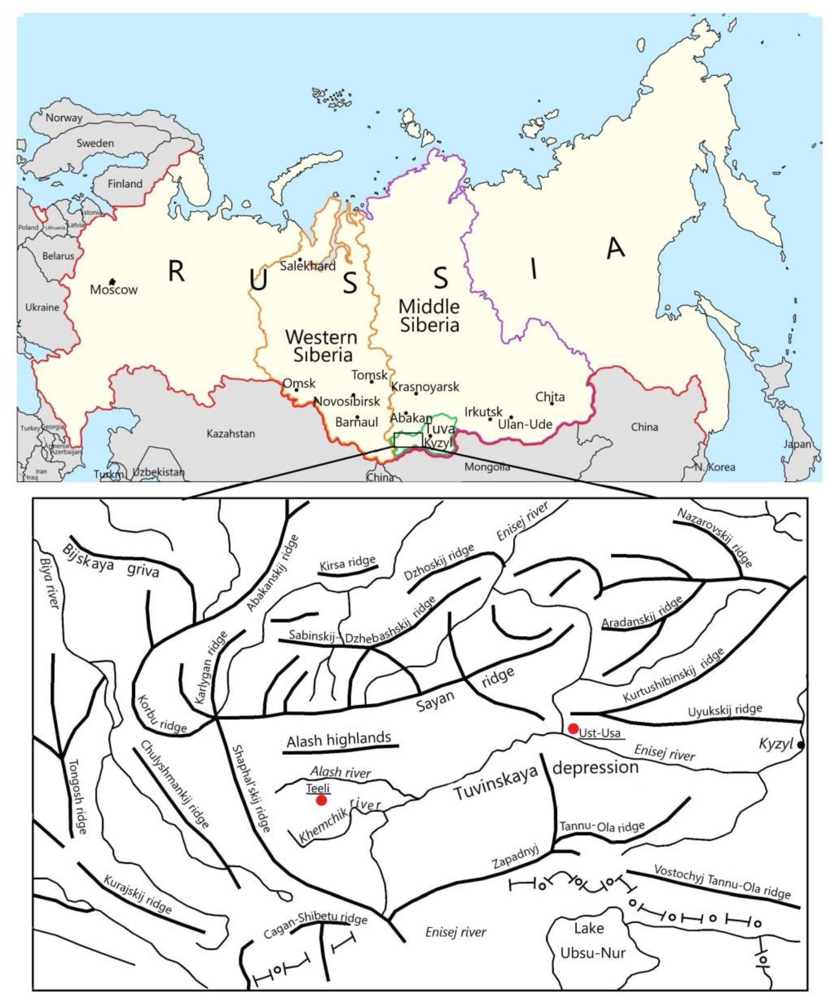
Figure 1. Location of study site at the map of administrative regions of Russian Federation; and the orographic scheme of the Republic of Tuva. The red dots depict the location of meteorological stations.
Atmosphere 13 00032 g001
Figure 2. The key site (palsa mire) marked with black bound in Adyr-Khem river valley (on topographic map and satellite image Sentinel-2B, shooting date 27 August 2019). Coordinates of the boundaries of the key site: the westernmost point 89.9357 51.6917; the easternmost point 89.9543 51.6914; the northernmost point 89.9468 51.6964; southernmost point 89.9418 51.6902.
Atmosphere 13 00032 g002aAtmosphere 13 00032 g002b
Figure 3. Adyr-Khem river valley at Alash plateau; southern slope of the Western Sayan montane region, Republic of Tuva, Russia (photo by Kvasnikov, 30 July 2020).
Atmosphere 13 00032 g003
Figure 4. The surface of frozen mound with cracks (a), and micro-depressions (b). The palsa mire sites in Adyr-Khem river valley at Alash plateau; southern slope of the Western Sayan montane region, Republic of Tuva, Russia. The photos are by Kvasnikova dated: 30 July 2020, 15 July 2021.
Atmosphere 13 00032 g004
Figure 5. The soil profile at heaving (frozen) mound in Adyr-Khem river valley. The palsa mire sites in Adyr-Khem river valley at Alash plateau; southern slope of the Western Sayan montane region, Republic of Tuva, Russia. The photo is by Kvasnikova dated 30 July 2020.
Atmosphere 13 00032 g005
Figure 6. Loss on ignition (LOI); the content of calcium, sulfur, and phosphorus in the soil profile at palsa key site.
Atmosphere 13 00032 g006
Figure 7. The open water bodies at the study site compiled for the reference date: 15 July 2021. Adyr-Khem river valley at Alash plateau; southern slope of the Western Sayan montane region, Republic of Tuva, Russia. The marks L.1 and L.2 refer to location of (untitled) thermokarst lakes studied in Section 3.3. An assessment based on interpretation of satellite imagery (Sentinel-2b, 10 m/pix resolution) along with images obtained with a drone Autel Evo ii 6k pr.
Atmosphere 13 00032 g007
Figure 8. Drone panorama of the Adyr-Khem study site (compiled by Andrey Kuznetsov in 15 July 2021).
Atmosphere 13 00032 g008
Figure 9. A system of lakes in the Adyr-Khem river valley at Alash plateau; southern slope of the Western Sayan montane region, Republic of Tuva, Russia. (photo by S. Kirpotin, 5 August 2021).
Atmosphere 13 00032 g009
Figure 10. Flow (water) channel at the Adyr-Khem key site (photo by Volkov, 2021). On the slope, a forest belt is formed, which has two thermal boundaries—the “classical” upper forest line and the lower boundary associated with the sinking of cold air to the bottom of the Adyr-Khem valley.
Atmosphere 13 00032 g010
Figure 11. The features of soil profile (section) at the heaving (frozen) peat mound in the Adyr-Khem river valley (Volkova, 2021).
Atmosphere 13 00032 g011
Figure 12. The main types of mires at the Adyr-Khem key site: (a)—dwarf shrub-moss mires, (b)—small fragment of dwarf shrub-moss mire dominated by Sphagnum mosses, (c)—on top of a hillock on shrub-moss mire dominated by green mosses, (d)—complex moss cover in dwarf shrub-Sphagnum mire, (e)—micro-subsidence on the surface of hillock with lichens, (f)—fen with sod tussocks (Deschampsia cespitosa) and green mosses (photos by Volkov, 5 August 2021).
Atmosphere 13 00032 g012aAtmosphere 13 00032 g012b
Figure 13. The main types of mire ecosystems at the Adyr-Khem key site: (a)—dwarf birch-Sphagnum ridges; (b)—plant community with dwarf willow (Salix rectijulis) and green moss (Paludella squarrosa); (c)—plant community with Comarum palustre; (d)—plant community dominated by cotton grass (Eriophorum polystachyon); (e)—hummock fen dominated by Deschampsia cespitosa; (f)—willow-herb-green moss community (photos by Volkov, 5 August 2021).
Atmosphere 13 00032 g013aAtmosphere 13 00032 g013b
Figure 14. Air temperature values for different periods at two meteorological stations: Ust-Usa (in red) and Teeli (in blue).
Atmosphere 13 00032 g014
Table 1. Location of test sites for physicochemical and microbiological analysis in the open water bodies.
The Name of Water BodyLatitude, (N)Longitude, (E)Water Surface Area of Lakes, m2
Ak-Sug river51.4405590.33989N/A
Adyr-Khem river51.69150089.951536N/A
Untitled Thermokarst Lake 151.69286789.952174330
Untitled Thermokarst Lake 251.69209589.951761102
Table 2. Рhysico-chemical and microbiological characteristics of lake and river waters.
The Name of Water BodypHElectrical Conductivity, µS·cm−1CO2 (µmol·L −1)O2 (DO%)Total Number of Bacteria, Mln Cells/mL
Untitled Thermokarst Lake 18.5 ± 0.456.6 ± 19.0169.0 ± 97,697.6 ± 29.31.8 ± 1.5
Untitled Thermokarst Lake 28.3 ± 1.219.1 ± 1.3521.5 ± 419.395.5 ± 25.23.5 ± 0.5
Ak-Sug river8.1 ± 0.2124.4 ± 7.9542.0 ± 103.284.4 ± 9.91.1 ± 0.1
Adyr-Khem river8.0 ± 0.695.9 ± 5.82872.5 ± 173.288.5 ± 16.31.5 ± 0.2
Thermokarst lakes in Altai mountain region *8.5 ± 0.5260.0 ± 165.2no data67.1 ± 49.5no data
Thermokarst Lakes in Western Siberia **
Isolated permafrost4.5 ± 0.518 ± 3.686.2 ± 24.0no datano data
Sporadic permafrost4.4 ± 0.226 ± 7.9156 ± 251.0no datano data
Discontinuous permafrost4.7 ± 0.523 ± 8.2139 ± 128.0no datano data
Continuous permafrost6.6 ± 0.624 ± 8.917.0 ± 75.0no datano data
* The data of Volkova et al. [22] ** The data of Manasypov et al. [62].
Publisher’s Note: MDPI stays neutral with regard to jurisdictional claims in published maps and institutional affiliations.