Article

The Influence of Typhoon “MITAG” on Waves and Currents in Zhoushan Sea Area, China

1
Marine Science and Technology College, Zhejiang Ocean University, Zhoushan 316022, China
2
Zhejiang Marine Fisheries Research Institute, Zhoushan 316021, China
3
Zhoushan Natural Resources Surveying and Mapping Design Centre, Zhoushan 316000, China
*
Author to whom correspondence should be addressed.
Atmosphere 2021, 12(8), 1027; https://doi.org/10.3390/atmos12081027
Submission received: 19 July 2021 / Revised: 9 August 2021 / Accepted: 10 August 2021 / Published: 11 August 2021
(This article belongs to the Special Issue Asia-Pacific Region: Monsoons and Typhoons)

Abstract

:
Typhoon “MITAG” was generated at the end of September 2019 and landed briefly in Zhoushan on October 1. Based on reanalysis data provided by ERA5 and NCEP, this paper analyzes the characteristics of wave and current during “MITAG”. The variation rule of waves and currents in different periods during the influence of “MITAG” was found. The results are as follows: The variation of significant wave height and mean wave period is related to its waveform. The single waveform has a long wave period and the correlation between wave height and wave period reaches 0.87 during the wind wave period. The wave period of the mixed waveform is shorter. The Ekman pumping of the ocean by “MITAG” is concentrated on the right side of the typhoon path when it is away from land; however, Ekman pumping is on the land side when the typhoon is close to the land. The sea surface height of the coastal sea area changes regularly with the distance of “MITAG”. The area which has a strong current is consistent with higher wave height.

1. Introduction

Typhoon is a strong air–sea interaction process which affects the coastal area. Strong cyclonic vortices often formed over the tropical ocean, these strong cyclone systems tend to bring heavy precipitation and rough waves to the coastal areas. During 1949–2018, a total of 2999 typhoons were generated in the Northwest Pacific Ocean (NPO), among which 627 landed over the coastal area of China [1]. On average, 32.8 typhoons were generated in NPO per year, and nine typhoons caused landfall over the China coast. Not only can storms and torrential rain brought by typhoons cause serious damage to coastal areas, but also rough waves cause great losses to coastal facilities, such as ports and ships.
In order to reduce the losses caused by a typhoon, several scholars have been analyzing and studying typhoons about their effects and the theories behind them [2,3,4,5,6]. Su et al. [1] analyzed the characteristics of typhoons that landed in China from 1949 to 2018. The result indicates that the number of typhoons decreased nearly 21.9% in recent 70 years. A large number of clouds will be produced when typhoon transits, and ordinary remote sensing methods, cannot penetrate the clouds. Zhu et al. [7], analyzed the influence of typhoon on marine dynamic environment by microwave remote sensing. Because of the sea surface temperature (SST) of the equatorial and Northwest Pacific it was warmer when the subtropical high ridge was located at 30° N. Typhoons are more frequent in summer, from July to September, especially in August [8]. Typhoon produces strong wind and heavy rainfall. A strong deep typhoon low pressure system is a prerequisite for rainfall [9].
Some scholars are interested in the interaction between the typhoon and ocean, such as waves and currents. Wang Y. et al. [10] found that the continuous isotropic wind had an obvious influence on the increase in wave height—the maximum wave height, the longer the wave period and the greater the proportion of wind wave. Qiu S. et al. [11], based on satellite remote sensing products, employed an empirical orthogonal function (EOF) to analyze wave and wind fields, and concluded that the wave variation is forced by the sea surface wind. Xiao L. et al. [12], based on FVCOM, simulated the response process of the upper ocean in the period of typhoons “RAMMASUN” and “MATMO”, and the results indicate that the variety in the current field can reach 0.4 ms−1 during a typhoon. Verena H. et al. [13] studied the response of upper ocean currents of “FANAPY” typhoon in 2010 found that the near-inertial currents generated during the storm showed the rightward bias, and the peak speed was up to 0.6 ms−1. The passage of typhoons will affect sea surface heights and vortices [14,15,16,17]. Wind stress also causes changes in the volume transport and mixing layer of seawater. The ocean mixing layer is deepened and thickened by wind entrainment and pumping. Due to higher intensity of the typhoon, this leads to a deepening of the mixed layer [18].
Several studies illustrate the interaction between waves and currents [19,20,21,22]. In general, the physical terms of wave–current interaction include wind stress, bottom friction stress, wave radiation stress and Coriolis–Stokes force [12]. The wave radiation stress can affect the horizontal current field and change the current direction regularly by transferring momentum flux [23]. In the offshore, the wave radiation stress will change with the wave height, which will lead to the stress imbalance on the water per unit area and drive the water to produce nearshore current [24]. Under strong wind, the enhancement of surface wind stress has a certain modulation effect on the sea surface current field [25]. Waves can increase wind stress, thus affecting the sea surface current [26]. Lin and Yin [27] found that the surface wind stress under wave action is 1.5 times higher than that without considering wave action, under strong wind.
Waves and surface currents are important physical processes of sea–air interaction. Typhoon low-level wind stress has the most direct impact on the sea surface to enhance strong air–sea interaction. In addition, the effects of typhoons on waves and currents will intensify the mixing of ocean surface, thus affecting SST and heat flux [28]. The heat exchange between the ocean and the typhoon core is an important factor which affects the intensity of a typhoon [29]. So, there is an inseparable interaction between the ocean and typhoons.
Several studies were carried out for ocean environment variation during the typhoon over east China. However, typhoon influence on waves and currents near the East China sea coastal area has not been exclusively studied. Study of waves and currents during a typhoon can promote the prevention of coastal disasters. Therefore, an attempt has been made to study the typhoon’s impact on the ocean currents and waves for the typhoon “MITAG”, presenting the characteristics of waves and current, and the relationship between them.

2. Typhoon “MITAG”

Typhoon “MITAG”, formed at 08:00 on 28 September over the NPO with a central pressure of 998 (hpa) and a wind speed of 18 ms−1 and moved northwest. In the early hours on 29 September, it was upgraded to a tropical storm and then to a typhoon at 20:00 on 29 September, then moves to the northwest direction at 25–28 km per hour. Its intensity peaked on the evening of 30 September. After reaching peak intensity, the typhoon began to weaken gradually and became a severe tropical storm at 20:00 on 1 October. At the same time, it landed in Putuo District, Zhoushan city, Zhejiang Province. The maximum wind force in the center was level 11, the wind speed was 30 ms−1, and the lowest pressure in the center was 980 (hpa). After landfall at Zhoushan, the typhoon further weakened and passed north to land at the coast of South Jeolla, South Korea at 8 o’clock in the evening of 2 October. Further, it entered Japan sea on 3 October and was deemed to have transformed into an extratropical cyclone. The complete track of typhoon “MITAG” is shown in Figure 1.
From 20:00 on 30 September to 8:00 on 2 October, the cumulative rainfall of Dinghai (district in Zhoushan) was 150–300 mm, Putuo and Daishan were 150–250 mm, and Shengsi (A county in Zhoushan, far away from the main island of Zhoushan) was 100–200 mm. In Zhoushan, there are 14 measuring stations with rainfall of more than 250 mm and two measuring stations with rainfall of more than 400 mm. From 18:00 to 21:00 on 1 October, the maximum rainfall in Dinghai reached 140 mm in 3 h, and the rainfall in 12 h reached 279.6 mm. The 12 h rainfall exceeded the maximum at Dinghai since meteorological records began in 1955. The vicinity of the area typhoon center wind reached 9–11 level, and the significant wave height reached 5.5 m.

3. Data and Study Area

3.1. Data

  • The selected typhoon path data are from the best typhoon path data obtained from RSMC (Regional Specialized Meteorological Center). Data contain the position (latitude and longitude) for each 6 h along with pressure and wind speed. (Available online: http://www.jma.go.jp/jma/jma-eng/jma-center/rsmc-hp-pub-eg/trackarchives.html (accessed on 15 February 2021).
  • The wave data are from ERA5 (European Environment Agency) datum of ECMWF (European Centre for Medium Range Weather Forecast) between 6:00 on 24 September and 6:00 on 06 October. (Available online: https://cds.climate.copernicus.eu/cdsapp#!/dataset/reanalysis-era5-single-levels?tab=form (accessed on 15 February 2021). The temporal and spatial resolution of wave datum are hourly and 0.25° × 0.25°, including significant wave height, mean wave period, significant height of wind wave, significant height of total swell wave.
  • The wind field, currents data, and SSH (Sea Surface Hight) are from NCEP (National Centers for Environmental Prediction) reanalysis datum CFSR (Climate Forecast System Reanalysis) between 6:00 on 24 September and 6:00 on 6 October. The resolution of temporal and spatial are 6 h and 0.205 degrees. (Available online: https://rda.ucar.edu/datasets/ds094.0/ (accessed on 15 February 2021).

3.2. Study Area

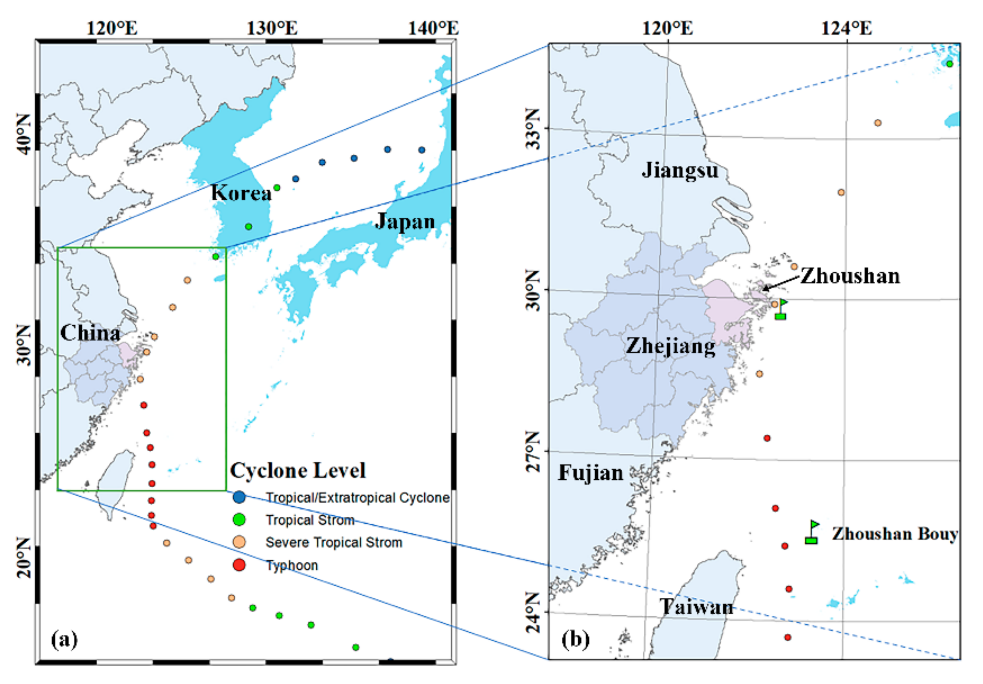
Typhoons are generally developed over tropical regions; the main water vapor and heat of tropical region come from the ocean and the Northwest Pacific has the best conditions for the formation of typhoons [30]. In this study, the East China Sea (17.18° E~131° E, 23° N~33.16° N) was selected as the study area (circled by the green box in Figure 2). However, Typhoon “MITAG” landed in Zhoushan (121.5° E~123.41° E, 29.53° N~31.07° N) and had a great impact over Zhoushan. Zhoushan Island is the fourth largest island in China, which is situated in the East China Sea, with a subtropical monsoon climate and being influenced by typhoons. We have chosen the MITAG typhoon to study the influence of typhoons over the Zhoushan area.

3.3. Data Feasibility

Reanalysis data combine model data with observations from across the world into a globally complete and consistent dataset using the laws of physics. The ERA5 reanalysis data used in this paper are commonly used in marine research [31,32]. This data set has also been used in the studies of typhoon prediction and impact [33,34,35]. Through literature investigation, it is found that the most advanced numerical model for typhoon prediction has a high resolution of 1.5 km [36,37]. The resolution of the latest model data in the horizontal and vertical aspects has been greatly improved, and the accuracy of typhoon simulation and prediction is higher. However, this paper mainly analyzes the large-scale marine impact of a typhoon on the sea area around Zhoushan, which does not require high data resolution. Therefore, ERA5 reanalysis data are more suitable for the analysis in this paper.
Although the reanalysis data are global model data, matching the measured data, there are still some differences in extreme weather. In order to verify the consistency of the data, this paper uses the sea surface pressure data in the reanalysis data set (6:00 on 30 September 2019–0:00 on 3 October 2019) to find the latitude and longitude corresponding to the lowest pressure value as the center position of the typhoon (if there are multiple minimum values, the average latitude and longitude are taken).
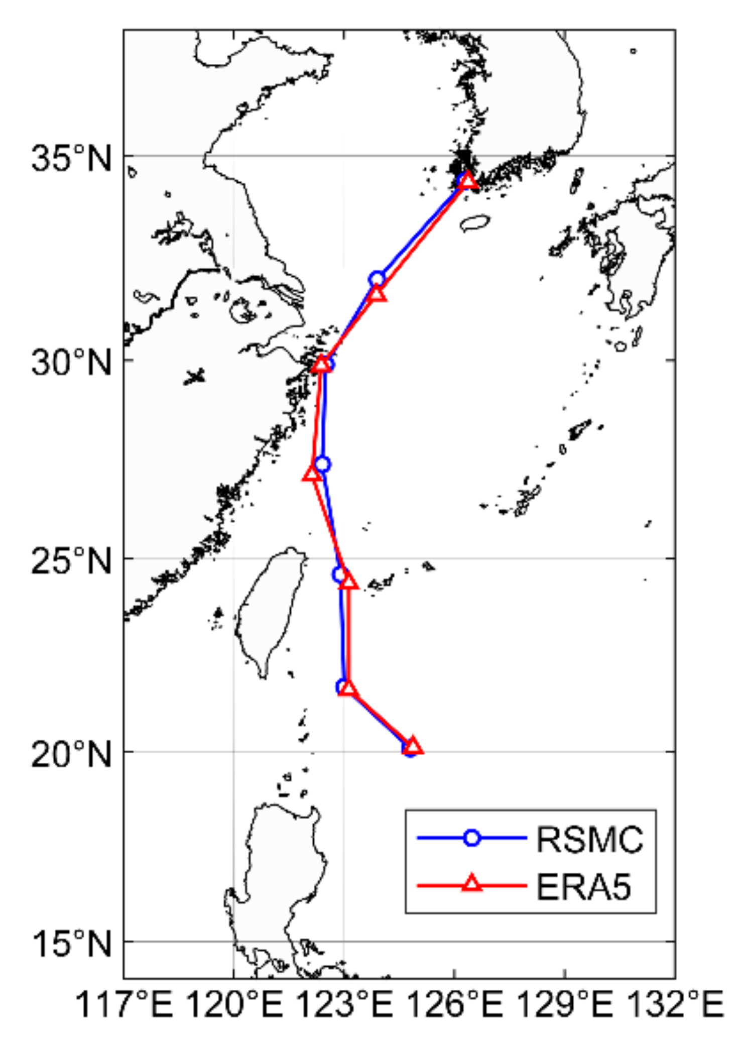
The typhoon track comparison between RSMC and ERA5 is shown in Figure 3.
According to Figure 3, it can be found that the typhoon path map obtained from the reanalysis data basically coincide with the optimal typhoon path of ESMC. Only individual point errors are greater than 0.25°, and the point errors within the study range are less than 0.25°. The maximum error is 0.59°, but the typhoon center obtained by era5 calculation is a region, and the average value of this region is taken as the typhoon center, so the error is acceptable. This dataset can meet the needs of this paper for the analysis of typhoon movement.

4. Methods

4.1. Wave Study Methods

In terms of waveform, waves can be divided into three types: swell, mixed wave, and wind wave. Waveforms are generally analyzed by means of significant wave steepness. According to Thompson’s theory, the significant wave steepness can be calculating as follows [38]:
δ = 1.949 π H g T 2
where, δ is the significant wave steepness, H is one-tenth of the average wave height (m), T is the period (s) of the corresponding wave height; g is the acceleration due to gravity. The significant wave steepness is higher, the larger the wind wave component [39]. When the significant wave steepness δ ≥ 1/40, the waveform is wind wave; when the 1/40 ≥ δ ≥ 1/100, the waveform is mixed wave; and the δ < 1/100, the waveform is swell [40].

4.2. Currents Study Methods

The pumping effect of the typhoon on the sea surface can be expressed by Ekman pumping velocity (EPV). EPV can reflect the intensity of upwelling under the influence of strong wind. Positive value means upwelling, and negative value means downwelling. The wind stress, curl (zonal and meridional) and EPV are calculated based on the formula given below [41,42]:
τ = ρ a C d U ¯ U ¯
c u r l τ = τ y i + 1 , j τ y i 1 , j 2 d x τ x i , j + 1 τ x i , j 1 2 d y
E P V = c u r l τ / ρ 0 f
where Ū is wind speed, ρa is the air density, Cd is the drag coefficient; τx and τy are the zonal and meridional wind stress, i and j are the number of rows and columns where the current grid point is located, dx and dy are the length and width of the grid, ρ0 is the sea water density, and f = 2ω sinφ is the geostrophic parameter. In this paper, the water density is 1020 kg m3.

5. Result

5.1. Analysis of Wave Characteristics during “MITAG”

The strong wind force of a typhoon on the sea surface can cause huge waves. The intensity of the wave at a given location depends on the distance from the typhoon and the intensity of the typhoon [10]. When the typhoon landfall, both storm winds and huge waves can damage offshore facilities. Therefore, it is of great significance to analyze the wave situation during the typhoon transit.

5.1.1. Waveform Evolution Characteristics

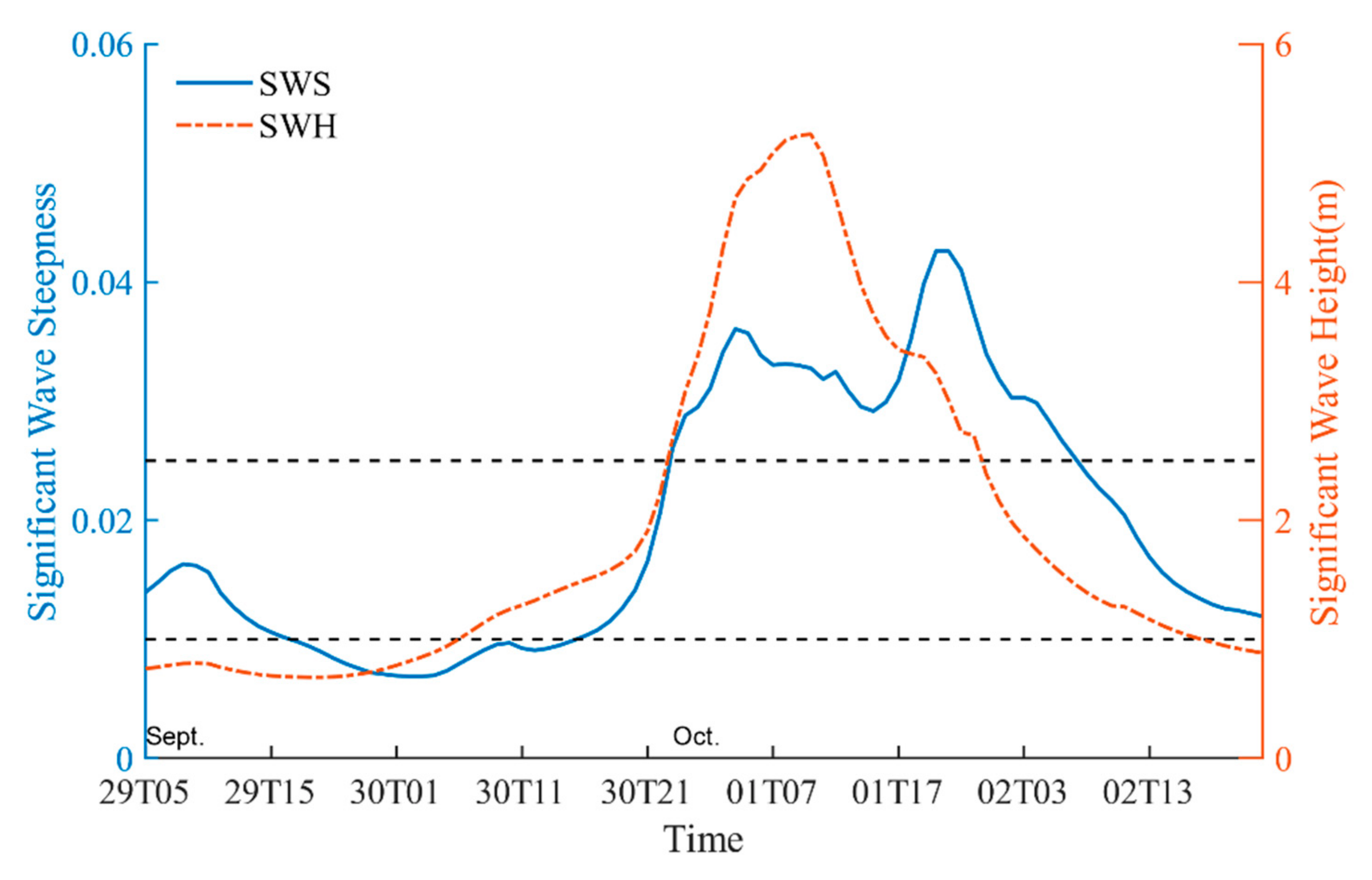
In order to analyze the time series of waves at Zhoushan near shore before and after the passage of typhoon, a representative buoy located in Zhoushan sea area was selected and the time series was extracted from the reanalysis data set [10]. The significant wave steepness (SWS) was calculated by using the mean wave period (MWP) and the significant wave height (SWH) and the joint analysis with the significant wave height are shown in Figure 4.
During the period of typhoon “MITAG”, from 18:00 on 29 September to 14:00 on 30 September, the SWS at Zhoushan sea area is always below 0.01, which was swell. From 17:00 on 29 September to 16:00 on 30 September, SWS exceeded 0.025, which was wind wave. While the SWS fluctuates between 0.01 and 0.025 at other times, which was mixed wave. From 18:00 on 29 September, “MITAG” has been identified as a tropical storm into a typhoon. However, due to the distance from Zhoushan, the waves near Zhoushan are less affected by the wind. The waveform was swell. As the typhoon continued to move northward, although the intensity of the “MITAG” was weak, due to the proximity of the distance, the waveform near Zhoushan was wind wave from 23:00 on 30 September to 8:00 on 2 October.
From Figure 3, the SWH in the sea area near Zhoushan first increases and then decreases with time. Before 21:00 on 30 September, due to the “MITAG” approaching Zhoushan, the wind in Zhoushan sea area gradually increased, the proportion of wind waves gradually increased, and the wind direction was relatively stable. Therefore, the SWS and SWH matching is better before 1 October. After “MITAG” landed at Zhoushan at 12:00 on 1 October, the wind speed weakened, and the wind direction changed rapidly. The change in SWS is due to the change in wind speed (Figure 3, but only the wind with fixed direction can make the SWH increase continuously. Therefore, when “MITAG” passes through Zhoushan sea area, the SWS fluctuates, but the SWH decreases continuously. When “MITAG” was far away from the Zhoushan sea area after 8 o’clock in the evening of 1 October. The trend of SWH and SWS matched well again.

5.1.2. Wave Height and Wave Period

According to the international sea and swell scale (Douglas sea scale, available online: http://www.euromete o.com/english/read/docdouglas (accessed on 20 January 2021) waves are divided into 10 classes, as shown in Table 1.
SWH and MWP were analyzed over Zhoushan sea area from 05:00 on 29 September to 00:00 on 3 October their joint distribution given in Table 2.
During the influence period of “MITAG”, the SWH of Zhoushan sea area changed from 0.6 m to 4.5 m, the wave grade was from slight to very rough, and the MWP varied from 5.2 s to 9.3 s. By analyzing the SWH and MWP at each time, the frequency of different SWH in different SWP were counted, which was given in Table 2. One can find that the MWP of slight varies from 5.2 s to 9.3 s and the MWP of moderate and rough is longer than 6 s. That of very rough is generally longer than 8 s.
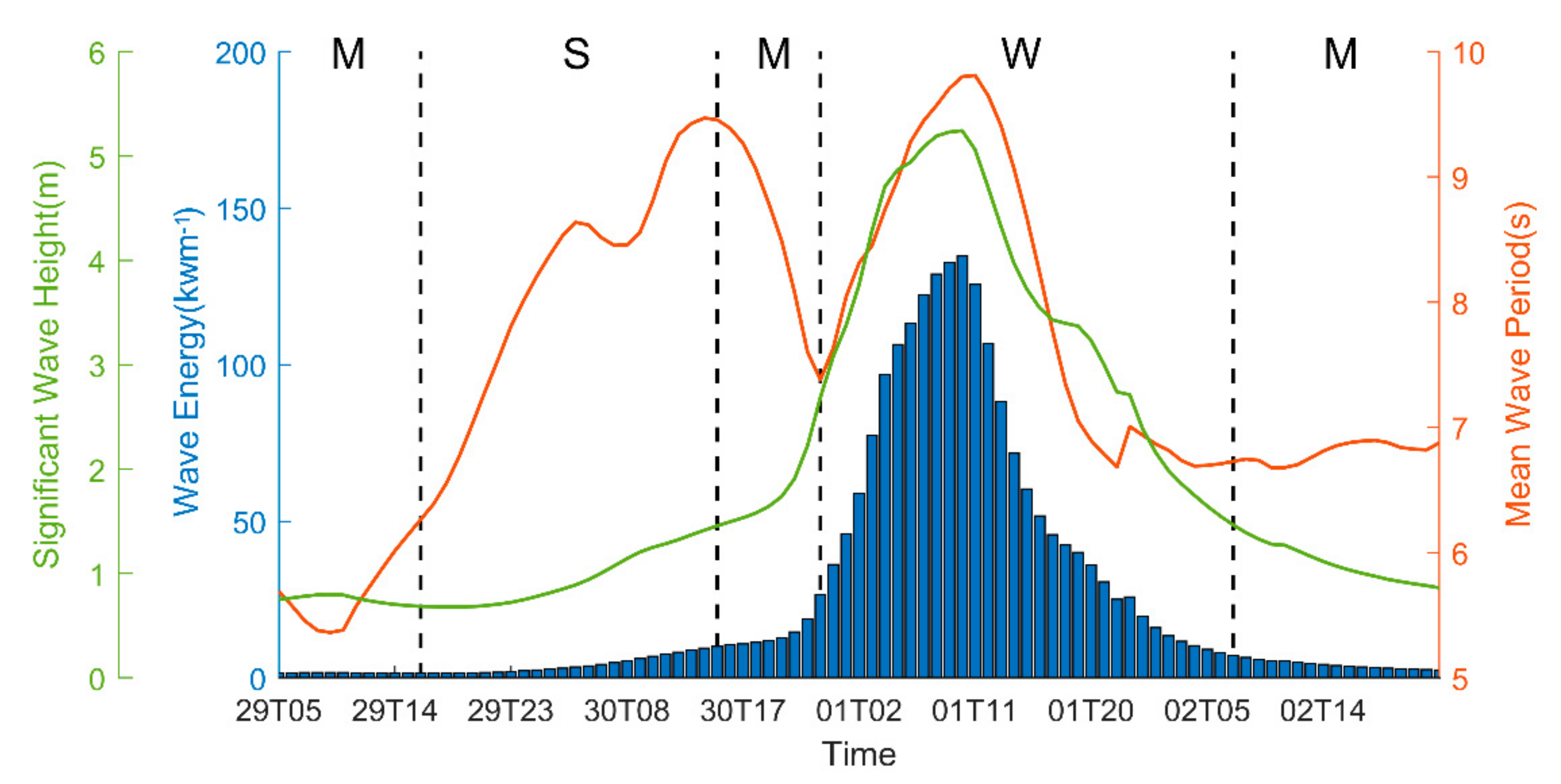
The SWH and MWP of each moment are shown in Figure 5. The solid line is mean wave period, the dashed line is significant wave height, and the vertical lines are used to divide the period which dominated by the different wave forms. According to Figure 5, it can be found that, from 5:00 to 18:00 on 29 September, the waves are mainly mixed waves, and the MWP is short. In the period of changes from mixed wave to swell wave, and the MWP increased gradually.
From 18:00 on 29 September to 16:00 on 30 September, the waveform was dominated by swell. The MWP becomes longer and increases from 6.3 s to 9.4 s. After 30 September, with the typhoon approaching, the wind intensity gradually increased, and the waveform also changed from swell to mixed wave. The MWP in this time became shorter with the increase in wind wave composition. This is because the wave here has just spread out the wind circle, the WE and SWH are slightly higher than the swell period, but the MWP drops rapidly, resulting in an increase in the wave frequency. However, with the further enhancement of wind, the MWP begins increase again, when the waveform becomes the wind wave, and the MWP changes with the SWH.
It can be concluded that the MWP is longer in single waveform, but shorter in mixed wave form. In the wind wave period, the higher the SWH, the longer the MWP.
The correlation between wave height and wave period are illustrated in Figure 6. It can be discovered that there is a positive correlation between SWH and MWP only when the waveform is wind wave, the correlation coefficient reached 0.870. In the time series, the correlation coefficient is only 0.309. The results of cross-correlation analysis of both reached the maximum when lag = 0. This shows that, when the waves have not yet propagated out of the wind zone, the influence of strong wind will make the SWH and MWP change synchronously. However, after the outgoing wind zone, this same trend variation is destroyed due to the weakening of wind influence.
Through the correlation analysis of MWP and SWH during the typhoon “MITAG”, it is found that there is no correlation between them, which is consistent with the previous research results [39,43]. However, when we only observe the waves in the dominant period of wind waves, there is a high correlation between them. This is because when “MITAG” is in Zhoushan sea area, the waves in Zhoushan sea area are all initial wind-driven waves, and the variation of SWH and MWP are directly affected by the wind speed. The higher SWH will cause the water points to move longer distances, and the MWP will increase. Swell is the wave after the initial wind-driven waves propagate out of the wind area, so the influence of wind is weakened. Due to the nonlinear interaction, the WE transfer to the low frequency, energy dissipation, frequency reduction and MWP growth [44]. During the impact of “MITAG”, when the “MITAG” gradually approached, the WE increased, so the SWH increased during the swell. In the mixed wave period, the WE here continuously increased. So, as the SWH and frequency increased, the MWP became shorter. Different from wind waves, swell and mixed waves are the result of wind wave propagation. Outside the typhoon circle, the wave period changes with the WE, and the WE are affected by many factors. However, the wave height is continuously decreasing. Therefore, the correlation between SWH and MWP is only reflected in the wind wave period.

5.2. Analysis of Currents Characteristics during “MITAG”

Typhoons will also have an impact on the currents. In particular, the entrainment and pumping of typhoons have remarkable impacts on the ocean currents at the surface layer. According to Ekman’s wind-driven current theory, when wind stress acts directly on the sea surface, horizontal turbulent shear stress transfers energy to the deep water, causing the sea water to move. The process is also subject to Coriolis forces [45]. The current eventually becomes stable due to the condition of equilibrium between turbulent shear stress and Coriolis force. Therefore, the passage of typhoon will have impact on the original sea current in its surface area both horizontally and vertically.

5.2.1. Characteristics of Ocean Currents near Zhoushan

The residual current in coastal waters of Zhejiang province is mainly affected by river runoff, especially the Yangtze River. Seasonal variations in ocean currents and winds can be observed. The residual current is mainly southward in winter and northward in summer. Residual current velocity is generally 0.1–0.2 ms−1. The surface residual current is strong in winter and weak in summer, which is caused by the strong north wind in winter and the southward flow of the Yangtze River diluted water, while the northern wind is weak in summer and the strengthening of the Taiwan Warm current leads to the northward flow of residual current in summer [46].

5.2.2. Influence of “MITAG” on the Sea Surface Current

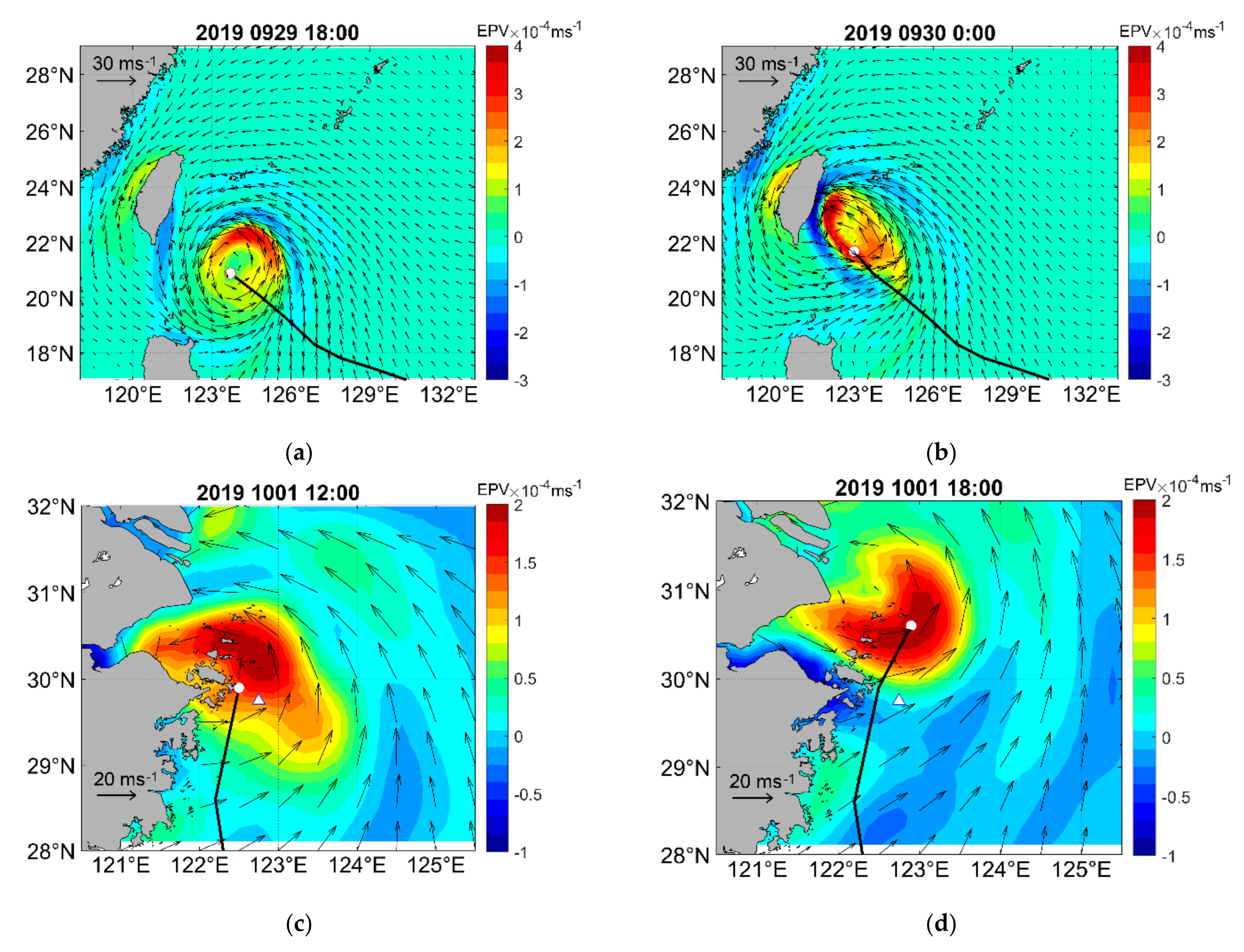
The EPV variation results are plotted in Figure 7. The vector is wind field, and the color is EPV. According to Figure 7a, since “MITAG” moved fast in the early stage, with the lowest speed of 5.5 ms−1, it can be found that the maximum value of EPV is located on the right side of the typhoon track. Especially after 18:00 on the 29 September, the wind intensity of “MITAG” reached level 12. East and southeast wind, combined with the cyclone strong wind field of “MITAG”, produced a persistent positive wind stress curl, which caused the sea surface water on the right side of the typhoon track to be driven by stronger and longer-lasting wind stress. Then, the wind produced stronger inertial flow and caused stronger entrainment and mixing. When “MITAG” was close to the land in the early morning of 30 September, due to the effect of land friction, the moving direction of “MITAG” changed from northwest to north. The downwelling are formed near the shore, which makes the area of the highest absolute value of EPV move to the area near the island in the left front of the typhoon path (Figure 7b). Similarly, by comparing the EPV before and after “MITAG” landed in Zhoushan on 1 October (Figure 7c,d), it can be found that, when the typhoon approached the land, the maximum EPV was observed near the land, and when the typhoon was far away from the land, the maximum EPV area was on the right side of the typhoon.
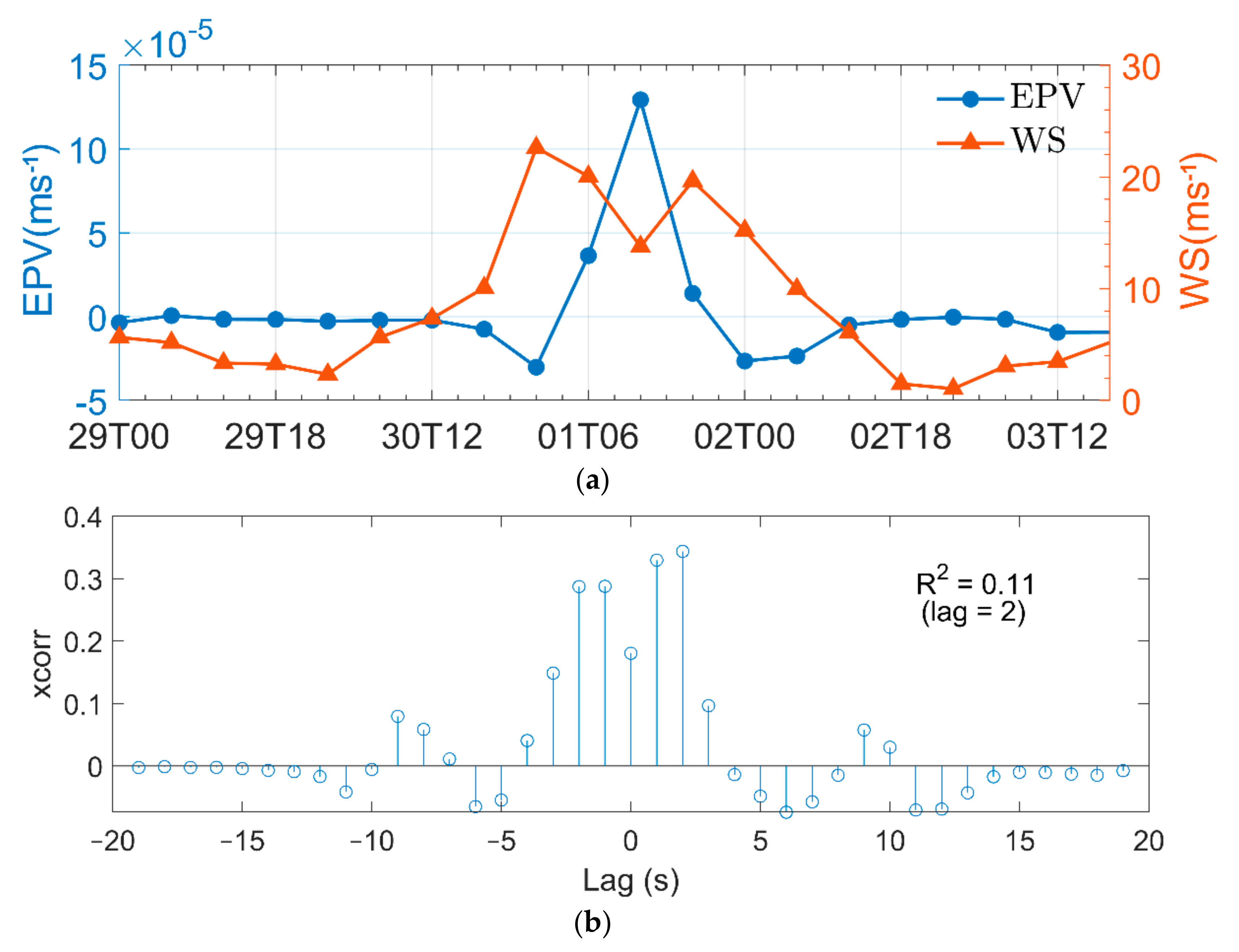
The EPV variations at Zhoushan sea area are illustrated in Figure 8. “MITAG” was affected from 18:00 on 30 September, the wind around Zhoushan began to strengthen and the EPV began to negatively increase, due to the Ekman pumping effect of “MITAG” center, which makes the sea water around the typhoon sink. However, as “MITAG” continues to approach, its pumping effect on the sea surface rapidly increases. At 12:00 on 1 October, since the Zhoushan sea area is close to the typhoon eye, the wind speed decreases, but the pumping effect is strong, and the EPV value reaches 12.9 × 10⁻⁵ ms−1 (Figure 7c). After 18:00 on 1 October, because the moving speed of the “MITAG” was slow, the EPV high value area was still near the Zhoushan sea area. However, the intensity of the typhoon had weakened, and the high value area of EPV reduced than before. (Figure 7d). The EPV value at the Zhoushan sea area decreased rapidly after 12:00 on 1 October. Then, EPV returned to zero after 12:00 on 2 October.
According to Figure 8, it can be found that the correlation between EPV and WS at different lags is quite different. When lag = 2, the positive correlation is the highest, R2 = 0.11. Therefore, there is no direct correlation between the two. Even EPV can be calculated by WS, there are many complex influencing factors, such as air density, terrain, etc. In the actual analysis, more spatial factors should be considered.
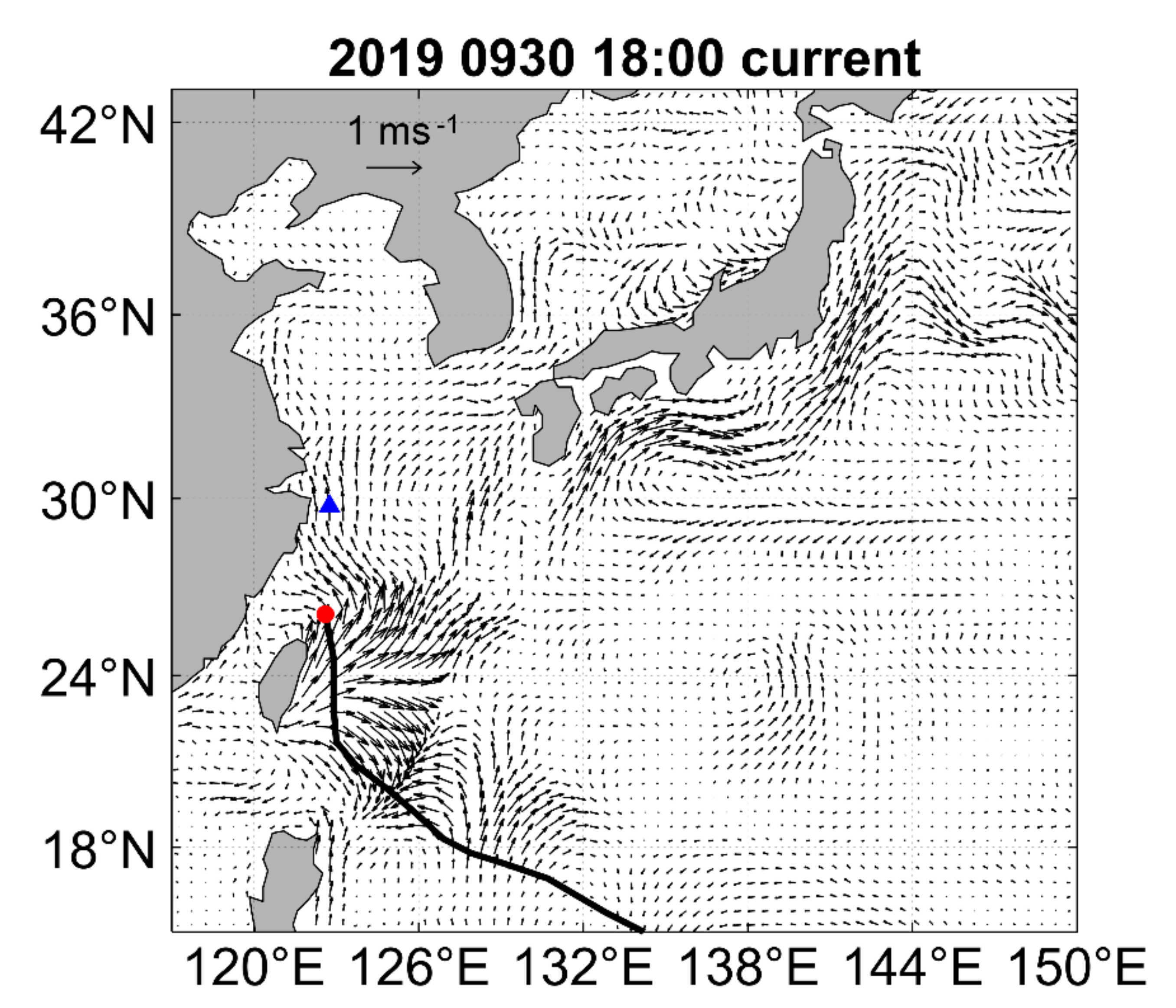
In order to further explore the influence of “MITAG” on the sea surface currents field, drawing the sea surface current field at 5 m depth. By observing Figure 9, it can be found that “MITAG” has a significant effect on the surface current field of the Kuroshio, and the sea surface current field is the result of common action of “MITAG” and the Kuroshio. At 18:00 on 30 September, the typhoon center moved to the north of Taiwan Island. The Kuroshio on the west side of Taiwan Island and the wind-driven current confluence in the opposite direction, showing irregular turbulence. On the east side, as the Kuroshio and the wind-driven current confluence in the same direction, the velocity increases.
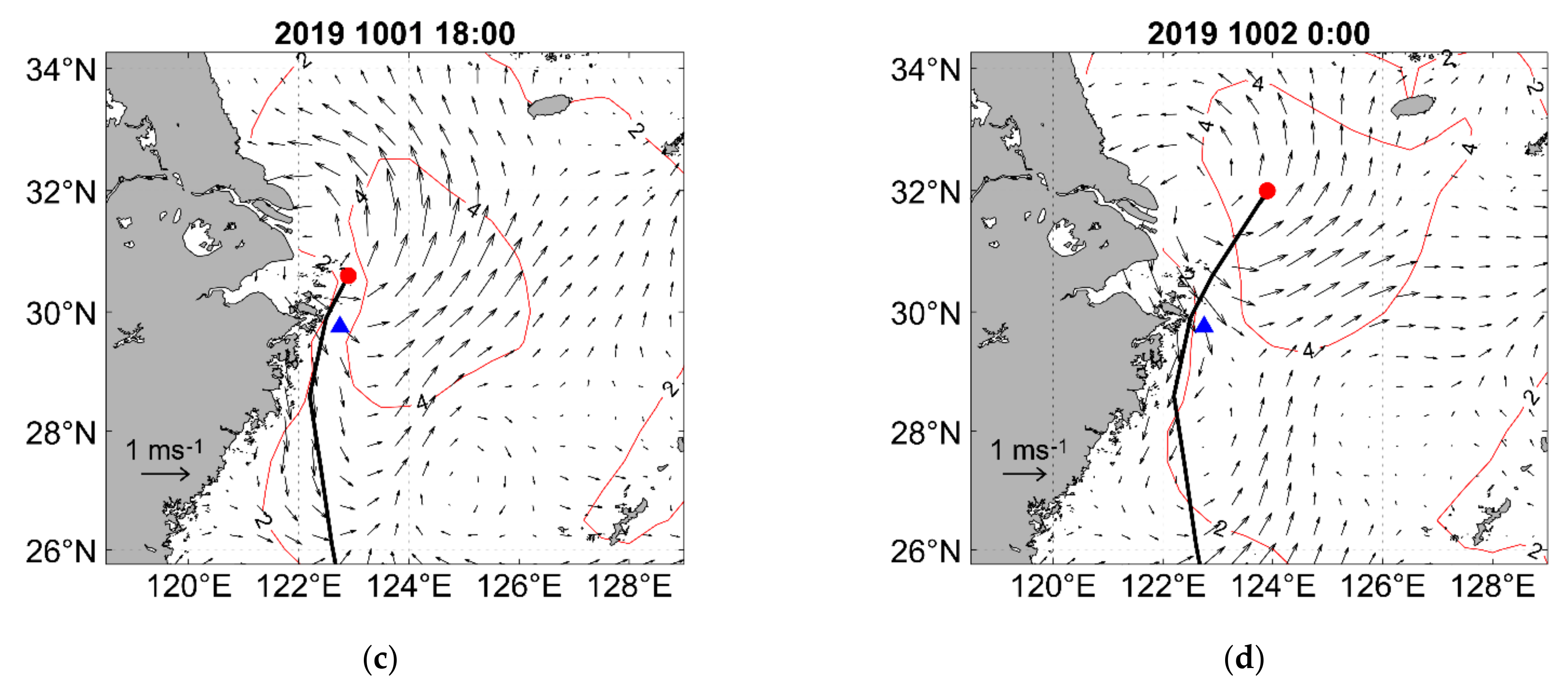
The sea surface current field in different periods near Zhoushan were plotted. The vector is currents, and the filling is sea surface height (Figure 10). It can be seen from Figure 11 that the sea surface height at Zhoushan sea area first increases and then decreases with the approach of “MITAG”. After 6:00 on 1 October, when the “MITAG” is close enough to the land, in addition to the divergence effect on the sea surface, which also form an offshore current along the coast, making the sea surface height decrease rapidly (Figure 10c,d).
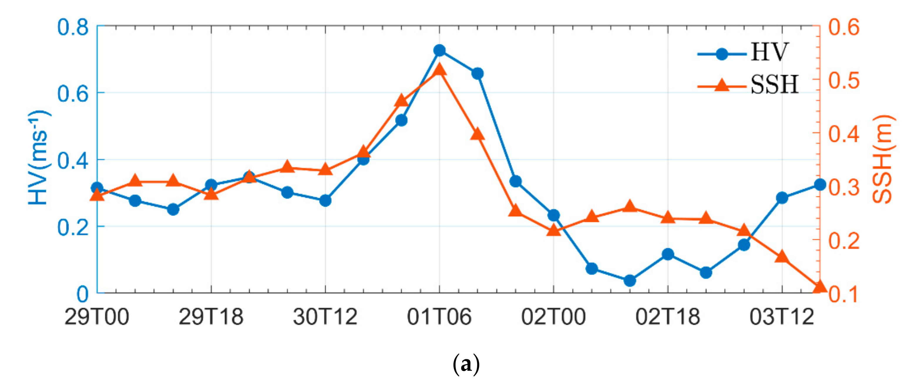
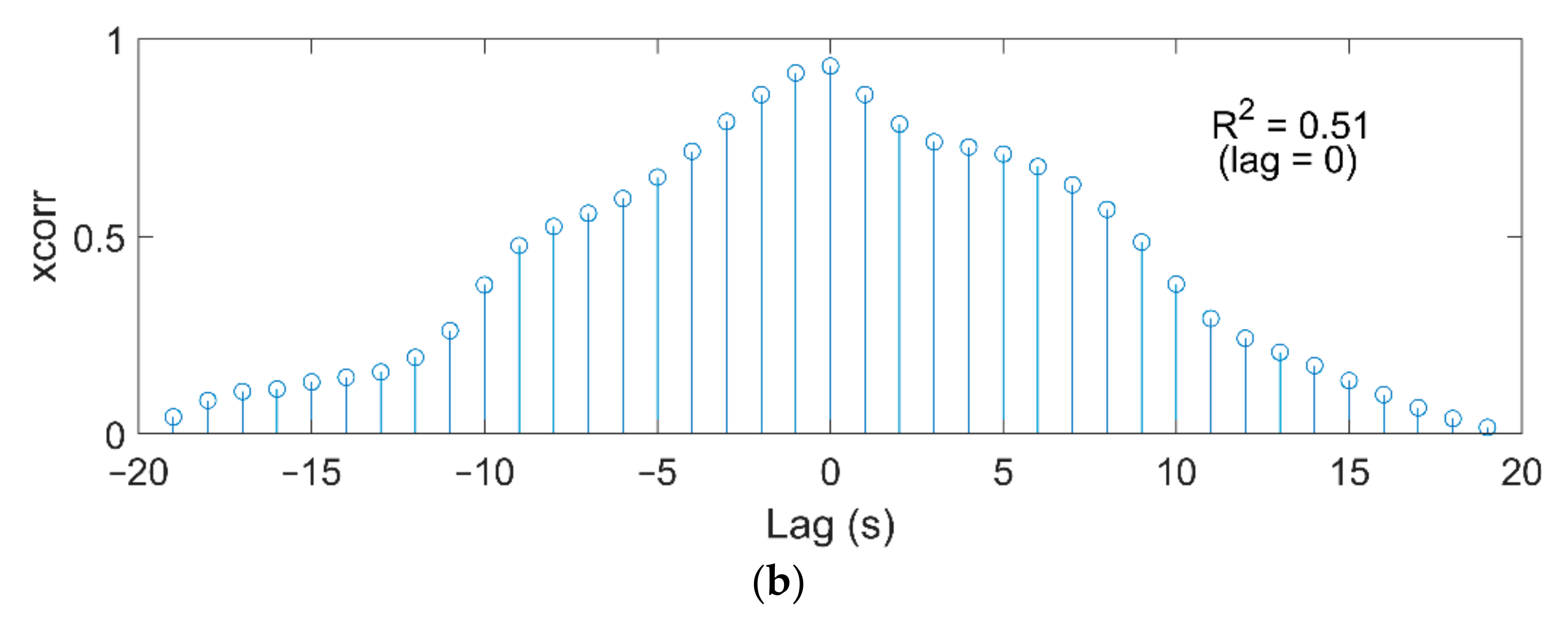
The current near Zhoushan is controlled by Kuroshio, so the coastal current is northward in autumn. When the “MITAG” approached Zhoushan on 1 October, the wind-driven current and the Kuroshio were in the same direction, so the currents velocity increased to 0.73 ms−1. However, as “MITAG” moved northward, the direction of the wind-driven current and the Kuroshio were changed, the velocity rapidly decreased to 0.07 ms−1 on 2 October. After 3 October, the typhoon was far away from Zhoushan sea area, and the surface currents field was no longer affected by the wind field; the velocity began to rise. Figure 11 depicts the variation of sea surface height and sea surface currents in Zhoushan sea area. When “MITAG” is close to Zhoushan, it produces onshore currents, which increase the sea surface height to 0.52 m. Then, with the approach of typhoon, the divergence at typhoon center and the offshore wind-driven current makes the sea surface height decrease to 0.21 m rapidly. After 2 October, the sea surface height slightly increased to 0.26 m again due to the short-term reverse intersection of wind-driven current and Kuroshio. Then, continue decreased to 0.11 m after 3 October. Observing Figure 11, that the development trend of the horizontal velocity at sea surface and the sea surface height is relatively consistent before 0:00 on 2 October. After 0:00 on 2 October, the horizontal velocity of sea surface and sea surface height showed a reverse trend, which was caused by the change in sea surface currents direction. According to Figure 11b, during the typhoon, HV near the shore has a moderate correlation with the SSH, and the correlation coefficient is 0.51. The overall development trend of the two is the same, and some differences should come from topographic factors.

6. Discussion

6.1. The Effect of Wind on Waves

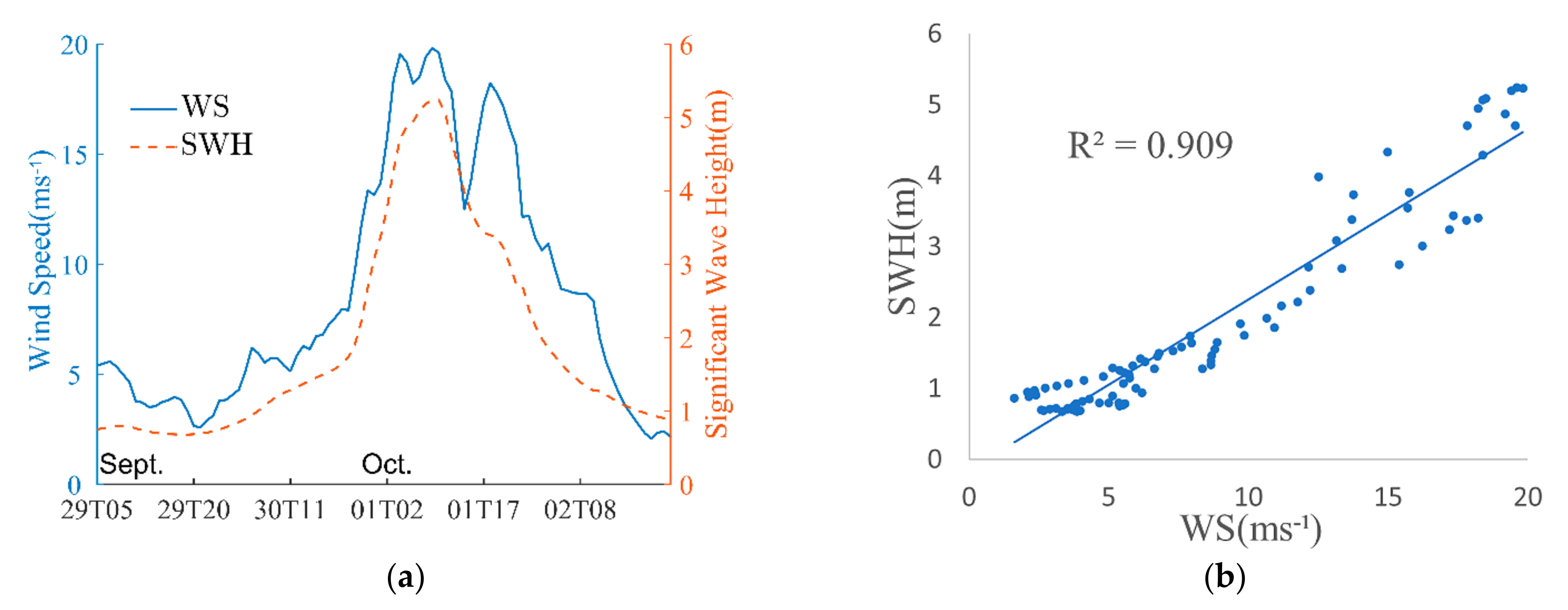
According to the components of wind field at Zhoushan sea area in U, V directions, the variation in wind speed and effective wave height are shown in Figure 12a. The wind direction at different times was calculated and put into a rose diagram. The joint analysis can clearly see the relationship between the significant wave height (SWH) and the wind speed (WS) during the typhoon.
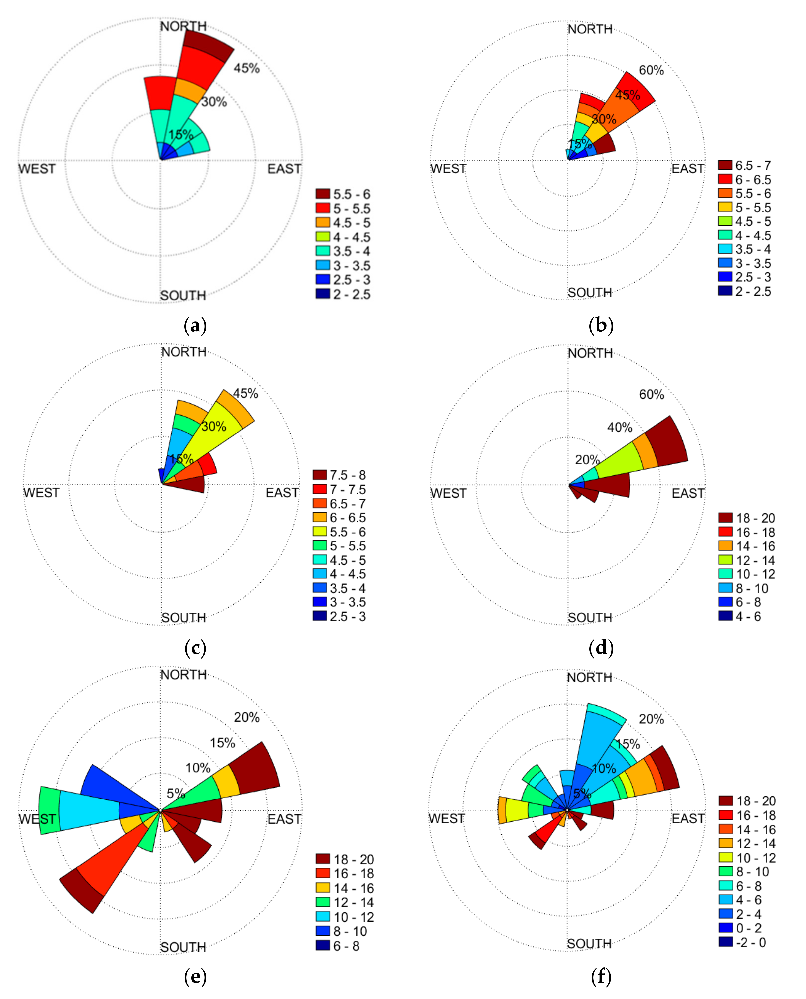
According to Figure 12, during the swell dominating period from 18:00 on 29 September to 14:00 on 30 September, the wind speed was under 10 ms−1 and fluctuated around 5 ms−1. Before 0:00 on 30 September, the wind speed was low and the distribution of wind direction was mainly north and northeast, as shown in Figure 13a. Although the wind direction was relatively stable from the northeast direction during the swell-dominating period, the overall wind speed fluctuated between 3.8 ms−1 and 6.7 ms−1 and was not high in that period. Therefore, the effect of the wind on the waves is not apparent in the early stage. After 18:00 on 29 September, “MITAG” was identified as typhoon. Nevertheless, it was far away from Zhoushan, so the waveform is swell. However, the wind direction was beginning to shift, as shown in Figure 13b. With the typhoon approaching, the wind speed at Zhoushan sea area rapidly increased, from 21:00 on 30 September to 10:00 on 1 October, its surge from 7.9 ms−1 to 19.8 ms−1. The significant wave height also increased with the increase in wind speed, and the wave height was close to 5 m. The wind direction is shown in Figure 13d.
In the early stage of the wind speed increasing period, starting from 0:00 on 30 September, the wind speed started increasing from 3.1 ms−1, then to 7.9 ms−1; the direction was from south by east. Until 21:00 on 30 September, the significant wave height grew slowly, because the wind speed was not high, as shown in Figure 13c. After 21:00, the wind speed began to surge and the direction was from northeast, as shown in Figure 13d. Days 30 September and 1 October are the spring tide. At this time, the Zhoushan tidal level is relatively high, and the current direction of the Zhejiang offshore area is northward, due to the influence of Kuroshio. The strong tide in the west direction, the northward residual current and the continuous strengthening of wind blowing from the east make the effective wave height rise rapidly from about 1.5 m to 4.5 m during this period.
The wind speed at Zhoushan increased on 1 October. The wind speed peaked at 10:00. After 10:00, the wind speed started to decrease. In the evening of 1 October, the wind speed rebounded from 12.5 ms−1 to 18.2 ms−1 from 16:00 to 20:00, but the significant wave height continued decreasing from 3.7 m to 3.1 m. According to Figure 13d, while the wind speed increased rapidly, the wind from east was strong and stable. Yet, after the wind speed peaked, there were some strong winds blowing from the southwest (Figure 13e). It is possible that the effective wave height did not rise with the wind speed because of the changes in wind direction, which we can observe from 16:00 to 20:00 on 1 October; the wind speed and significant wave height are opposite.
Some conclusions can be drawn from this. According to Figure 12, we can find that the wind was a major factor driving wave height. The correlation coefficient between wind speed and significant wave height reached 0.909, which demonstrates strong correlation. Spring tides and strong winds combine to create a rapid increase in significant wave height. Different wind directions have different effects on the waves.

6.2. The Effect of Waves on Current

The wave is an important physical process in the ocean, which has significant influence on other physical processes near the surface of the upper ocean [12]. When the wave height along the coast is different, the change in wave radiation stress field will provide the power to drive the coastal flow, then affect the current velocity along the coast [47]. The introduction of wave radiation stress theory can describe the energy exchange in the interaction between waves and currents to establish the conservation of wave energy [48].
For a clearer observation of wave–current interactions during “MITAG”, using the current field during “MITAG” subtracted the average current field of 9 years from 2011 to 2019, so as obtained a clearer sea surface current field variation in the influence of strong wind and waves shown in Figure 14.
According to previous studies, the existence of Coriolis–Stokes force will change the temperature and salinity of the upper ocean and the distribution of density [49]. The shear term of velocity increases the instability and changes the current field. The effect of Coriolis–Stokes force is only 10−3 ms−1. Wave radiation stress can also affect the horizontal flow field and change the direction of the current field regularly by transferring momentum flux, and the magnitude is about 0.1 ms−1 [23]. It can be seen from Figure 14 that the sea surface current field has an approximate cyclonic structure with a significant right deviation. The areas with large variation in current velocity are all distributed on the right side of the typhoon track, which is basically consistent with the regional distribution of significant wave height of over 4 m.
Due to the nearshore shallow water effect, the radiation stress on the unit water column is unbalanced, which will lead to the generation of nearshore currents [12]. This would cause variations in velocity at the sea area near Zhoushan, which is larger, exceeding 0.4 ms−1. The time series of SWH and current velocity at the Zhoushan sea area is shown in Figure 15.
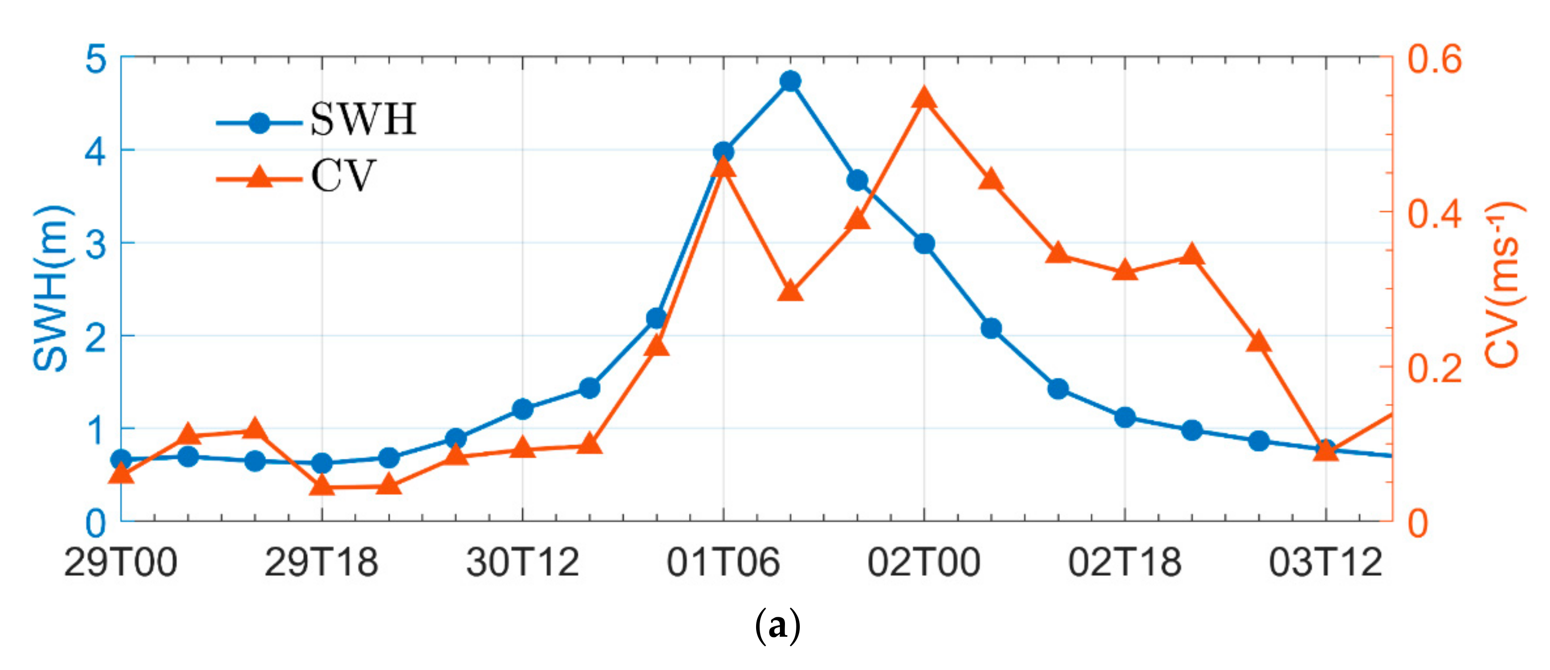
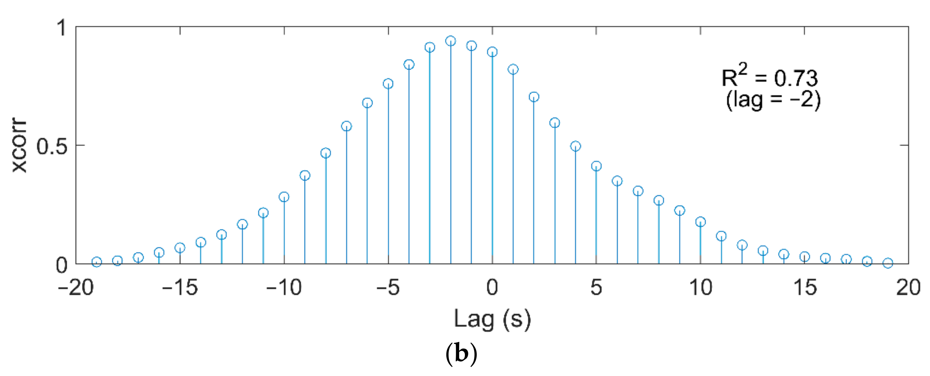
Before 12:00 on 30 September, the current velocity variation mainly fluctuated around 0.1 ms−1 and the wave height was less than 2 m. With “MITAG” approaching, the wave height increased, and the current velocity variation began to increase. At 6:00 on 1 October, the significant wave height reached 3.9 m, and the current variation at Zhoushan sea area increased to 0.45 ms−1. At this time, the current was subjected to the combined action of radiation stress and wind stress. At 12:00 on 1 October, “MITAG” hit the land at Zhoushan, and the wave height reached 4.7 m, but the current variation decreased to 0.29 ms−1. Because the direction of the current was toward the land and there were many islands near Zhoushan, the velocity slowed down for a short time. Then, this changed to the offshore current, and the velocity rose again. From Figure 14b, it can be found that the current field variation near the Zhoushan sea area is still significant. However, due to topography, the current velocity variation near the “MITAG” center is small. After 12:00 on 2 October, the “MITAG” continued to move northward. Although the effective wave height was reduced to 3 m, the direction of wind and the southward Yangtze water were maintained, making the current velocity variation to 0.54 ms−1. Then, with the “MITAG” passing away, significant wave height and sea surface current field variation continued to decrease. According to Figure 15b, it can be found that the change in CV caused a delay for the corresponding change in SWH. When lag is 2, the maximum correlation coefficient between them is 0.73. In summary, it can be found that the influence of waves on the surface current field is related to the strength of waves and topography.

7. Conclusions

The correlation between MWP and SWH is different in previous studies. In this paper, it was found that, whether or not the MWP and SWH of wind-generated waves are related, waveform plays a key role. During the lifetime of “MITAG”, the MWP of the mixed wave is short, and the single swell or wind wave is long. Especially when “MITAG” reaches Zhoushan sea area, the effect of wind on SWH and MWP is very obvious. Because most of the waves during the typhoon are initial wind-driven waves. The higher the SWH, the greater the distance the water points move, and the longer the MWP. Therefore, wind speed, SWH and MWP change together. Waves with higher SWH usually have longer MWP, and the correlation reaches 0.87.
When “MITAG” passes through the sea, it affects the ocean surface. Strong wind will form an Ekman pumping effect on the ocean surface, causing the vertical movement of water. Because when “MITAG” is near the shore, the shallower water depth is likely to form a stronger offshore flow, resulting in obvious Ekman pumping. The maximum area of Ekman pumping velocity is on the right side of the “MITAG” path when it is far from the land, and the maximum area is on the land side when “MITAG” is close to the land. The variation in Ekman suction is not only related to wind but also to terrain.
The current field near Zhoushan is affected by Kuroshio and Changjiang river diluted water. In strong wind conditions, the distribution of sea surface flow field is the result of the combined action of wind-driven current and circulation. The impact of “MITAG” on current also indirectly affects sea surface height. The enhancement of current in different directions of “MITAG” will have different effects on SSH. When “MITAG” is near, the SSH of Zhoushan sea area would increase by onshore currents. When it leaves, SSH is decreased by offshore currents.
Waves can exchange energy with current through radiation stress. This means there is a correlation between waves and currents near shore. At the shallow water depth in the nearshore, due to the wave driving, the movement of water to generate nearshore flow causes the cyclone structure of the current to be at the right of the “MITAG” track. When “MITAG” is at Zhoushan sea area, the strong current area is consistent with the high wave height area. However, further study is needed to quantify the disasters for different typhoons.

Author Contributions

Conceptualization, Y.N., B.G.; methodology, Y.N.; software, Y.N.; validation, Y.N., B.G. and M.V.S.; formal analysis, Y.N.; investigation, Y.N.; resources, B.G.; data curation, Y.N.; writing—original draft preparation, Y.N.; writing—review and editing, B.G., M.V.S., B.X., Y.Y.; visualization, Y.N.; supervision, B.G.; project administration, B.G.; funding acquisition, B.G. All authors have read and agreed to the published version of the manuscript.

Funding

This study is supported by the State Key Laboratory of Plateau Ecology and Agriculture, Qinghai University (Grant No. 2018-KF-02), the open research fund program of State Key Laboratory of Hydroscience and Engineering, Tsinghua University (sklhse-2021-B-01), the National Natural Science Foundation of China (Grant No. 51479179 and 51579230), the Science Foundation of Zhejiang Ocean University (Grant No. 21105011713), and Innovation and Development of Social Science in Anhui Province (No. 2019CX016).

Institutional Review Board Statement

Not applicable.

Informed Consent Statement

Not applicable.

Data Availability Statement

Not applicable.

Conflicts of Interest

The authors declare no conflict of interest.

References

  1. Su, H.; Dong, G.; Wang, M.; Yuan, L.; Fei, X. Analysis on Main Characteristics and Causes of Landfall Typhoons in Recent 70 Years. Environ. Sci. Manag. 2020, 45, 128–131. [Google Scholar]
  2. Peereman, J.; Hogan, J.A.; Lin, T.C. Assessing Typhoon-Induced Canopy Damage Using Vegetation Indices in the Fushan Experimental Forest, Taiwan. Remote Sens. 2020, 12, 1654. [Google Scholar] [CrossRef]
  3. Beirne, J.; Renzhi, N.; Volz, U. Bracing for the Typhoon: Climate Change and Sovereign Risk in Southeast Asia; ADBI Working Papers; ADBI: Tokyo, Japan, 2021. [Google Scholar]
  4. Tamura, H.; Kawaguchi, K.; Iwamoto, T. Coastal destruction and unusual wave spectra induced by Typhoon Faxai in 2019. Coast. Eng. J. 2021, 63, 92–105. [Google Scholar] [CrossRef]
  5. Okuwaki, R.; Fan, W.; Yamada, M. Multiple Small-Scale Landslides Triggered by Typhoon Talas 2011. 2020. Available online: https://eprints.whiterose.ac.uk/173217/ (accessed on 9 August 2021).
  6. Cao, H.; Han, L. Drift path of green tide and the impact of typhoon “Chan-hom” in the Chinese Yellow Sea based on GOCI images in 2015. Ecol. Inform. 2020, 60, 101156. [Google Scholar] [CrossRef]
  7. Zhu, S.; Yin, X. Typhoon influence on ocean dynamic based on microwave remote sensing. J. Terahertz Sci. Electron. Inf. Technol. 2020, 18, 64–69. [Google Scholar]
  8. Zhang, C.; Wang, L.; Sun, M.; Zhang, J. Tentative analysis on multi-typhoon characteristics and atmospheric circulation background in the midsummer of 2012. Torrential Rain Disasters 2012, 31, 298–305. [Google Scholar]
  9. Xie, S.; Su, X.; Liang, Y. An Analysis on Precipitation Characteristics of Typhoon “Prapiroon”. Trop. Geogr. 2008, 28, 21–25. [Google Scholar]
  10. Wang, Y.; Tu, X.; Jiang, L.; Fang, Y.; Xu, B. Analysis of wave characteristics along Zhejiang coast during typhoon “Lekima”. J. Meteorol. Sci. 2020, 40, 97–105. [Google Scholar]
  11. Qiu, S.; Liang, C.; Dong, C.; Liu, Z. Analysis of the temporal and spatial variation in the wind and wave over the South China Sea. J. Mar. Sci. 2013, 31, 1–9. [Google Scholar]
  12. Xiao, L.; Shi, J.; Jiang, G.; Liu, Z. The influence of ocean waves on sea surface current field and sea surface temperature under the typhoon background. Mar. Sci. Bull. 2018, 37, 396–403. [Google Scholar]
  13. Hormann, V.; Centurioni, L.R.; Rainville, L.; Lee, C.M.; Braasch, L.J. Braasch. Response of ocean currents to Typhoon Fanapi. Geophys. Res. Lett. 2014, 41, 3995–4003. [Google Scholar] [CrossRef]
  14. Ginis, I. Ocean Response to Tropical Cyclone. Chapter 5 of Global Perspectives on Tropical Cyclones; WMO/TD-No. 693; World Meteorological Organization: Geneva, Switzerland, 1995; pp. 198–260. [Google Scholar]
  15. Li, M. A Study on Reginal Characteristics and Influence Mechanism of Typhoon-Induced Ocean Eddies in the Eastern Chinese Seas. Ph.D. Thesis, Nanjing University of Information Science and Technology, Nanjing, China, 2017. [Google Scholar]
  16. Ling, C.; Liu, L.; He, W. Impact of a typhoon process on the source region of Northwest Pacific western boundary current system. Mar. Forecast. 2015, 32, 24–34. [Google Scholar]
  17. Lai, Q.; Wu, L. SHIE Chung-lin. Sea surface temperature response to typhoon MORAKOT (2009) and the influence on its activity. J. Trop. Meteorol. 2013, 29, 221–234. [Google Scholar]
  18. Chan, C.L.; Duan, Y.; Shay, L.K. Tropical cyclone intensity change from a simple ocean atmosphere coupled model. J. Atmos Sci. 2001, 58, 154–172. [Google Scholar] [CrossRef]
  19. Longuet-Higgins, M.S.; Stewart, R.W. Radiation stress and mass transport in gravity waves, with application to ‘surf beats’. J. Fluid Mech. 1962, 13, 481–504. [Google Scholar] [CrossRef]
  20. Donelan, M.A.; Dobson, F.W.; Smith, S.D. On the Dependence of Sea Surface Roughness on Wave Development. J. Phys. Oceanogr. 1993, 23, 2143–2149. [Google Scholar] [CrossRef] [Green Version]
  21. Xie, L.; Liu, H.; Peng, M. The effect of wave–Current interactions on the storm surge and inundation in Charleston Harbor during Hurricane Hugo 1989. Ocean. Model. 2008, 20, 252–269. [Google Scholar] [CrossRef]
  22. Xia, B.; Zhang, Q.; Jiang, C. A coupled wave—Current numerical model on unstructured grids. Oceanol. Limnol. Sin. 2013, 44, 1451–1456. [Google Scholar]
  23. Liu, L.; Fei, J.; Zhang, L. New parameterization of wave-current interaction used in a two-way coupled model under typhoon conditions. Acta Phys. Sin. 2012, 61, 59201. [Google Scholar]
  24. Zheng, J.; Yan, Y. Research and Application of Wave-Induced Radiation Stress Theory. Adv. Sci. Technol. Water Resour. 1999, 20, 5–7. [Google Scholar]
  25. Hasselmann, K. Wave-driven inertial oscillations. Geophys. Astrophys. Fluid Dyn. 1970, 1, 463–502. [Google Scholar] [CrossRef]
  26. Xie, L.; Wu, K.; Pietrafesa, L. A numerical study of wave-current interaction through surface and bottom stresses Wind-driven circulation in the South Atlantic Bight under uniform winds. J. Geophys. Res. Atmos. 2001, 106, 16841–16856. [Google Scholar] [CrossRef] [Green Version]
  27. Lin, X.; Yin, B. Influence of interaction of waves in tide-surge on surface wind stress coefficient. J. Hohai Univ. (Nat. Sci.) 2007, 35, 714–717. [Google Scholar]
  28. Xu, H.; Du, H.; Xiang, J.; Cao, J. The characteristics of ocean wave induced by typhoon “Megi” (2010) and its influence on the ocean and atmosphere. Mar. Forecast. 2020, 37, 6–16. [Google Scholar]
  29. Emanuel, K. Thermodynamic control of hurricane intensity. Nature 1999, 401, 665–669. [Google Scholar] [CrossRef]
  30. He, L.; Wang, Y.; Ma, X. Matching Relation among TC Initiating Locations of High Frequency, SST Warm-Water Region and ITCZ Measured by GMS-5 in the North-West Pacific Ocean. J. Nanjing Inst. Meteorol. 2006, 29, 440–447. [Google Scholar]
  31. Kumar, P.; Kaur, S.; Weller, E.; Young, I.R. Influence of Natural Climate Variability on Extreme Wave Power over Indo-Pacific Ocean Assessed Using ERA5. 2021. Available online: https://www.researchsquare.com/article/rs-372607/v1 (accessed on 9 August 2021).
  32. Patra, A.; Min, S.; Seong, M. Climate Variability Impacts on Global Extreme Wave Heights: Seasonal Assessment Using Satellite Data and ERA5 Reanalysis. J. Geophys. Res. Ocean. 2020, 125, e2020JC016754. [Google Scholar] [CrossRef]
  33. Zhang, R.; Liu, Q.; Hang, R.; Liu, G. Predicting Tropical Cyclogenesis Using a Deep Learning Method from Gridded Satellite and ERA5 Reanalysis Data in the Western North Pacific Basin. IEEE Trans. Geosci. Remote. Sens. 2021, 99, 1–10. [Google Scholar]
  34. Yitian, Q.; Qibang, X. Early onset of the typhoon season over the western North Pacific in 2015: Influence of the 2015/2016 super El Ni(n)o event. Trans. Atmos. Sci. 2016, 039, 788–800. [Google Scholar]
  35. Xue, L.; Li, Y.; Wang, B.; Zhou, R. Characteristics of tropical cyclone-induced low-level wind fields over Hainan. Clim. Environ. Res. 2018, 23, 299–310. (In Chinese) [Google Scholar]
  36. Feng, J.; Wang, X. Impact of Increasing Horizontal and Vertical Resolution during the HWRF Hybrid EnVar Data Assimilation on the Analysis and Prediction of Hurricane Patricia (2015). Mon. Weather. Rev. 2020, 149, 419–444. [Google Scholar] [CrossRef]
  37. Biswas, M.K. Hurricane Weather Research and Forecasting (HWRF) Model: 2018 Scientific Documentation. 2018. Available online: https://dtcenter.org/HurrWRF/users/docs/index.php (accessed on 11 May 2021).
  38. Wen, S.; Yu, Z. Wave Theory and Computational Principles; Science Press: Beijing, China, 1994; pp. 110–112. [Google Scholar]
  39. Sun, L.; Huang, C.; Cai, W. Statistical analysis of wave characteristics in the Guanghai Bay. J. Trop. Oceanogr. 2014, 33, 17–23. [Google Scholar]
  40. Thompson, W.C.; Nelson, A.R.; Sedivy, D.G. Wave group anatomy of ocean wave spectra. In Proceedings of the 19th International Conference on Coastal Engineering, Houston, TX, USA, 3–7 September 1984; pp. 661–677. [Google Scholar]
  41. Wang, T.; Zhang, S.; Chen, F. Upper Ocean Response to Sequential Typhoons in Northwest Pacific Ocean. J. Guangdong Ocean. Univ. 2019, 39, 62–74. [Google Scholar]
  42. Zhang, Z. A case study of the response of northwest Pacific upper ocean to typhoon. Mar. Sci. Bull. 2019, 38, 562–568. [Google Scholar]
  43. Kong, Y.; Ding, P.; Zhou, G. Characteristic Analyses of Storm Waves in the Changjiang Estuary. J. East China Norm. Univ. (Nat. Sci.) 2001, 3, 85–90. [Google Scholar]
  44. Li, J.; Zheng, C.; Liu, K. Numerical analysis of wave energy propagation regulation. J. Harbin Eng. Univ. 2021, 42, 49–54. [Google Scholar]
  45. Tian, Z. Parameters optimization research of Ekman wind current model. Trans. Oceanol. Limnol. 2018, 1–9. [Google Scholar] [CrossRef]
  46. Chen, Q.; Huang, D. Characteristics of the tidal current and residual current in the seas adjacent to Zhejiang. Donghai Mar. Sci. 2003, 21, 7–13. [Google Scholar]
  47. Basco, D.R. Surf zone currents. Coast. Eng. 1983, 7, 331–355. [Google Scholar] [CrossRef]
  48. Phillips, O.M. The Dynamics of the Upper Ocean. Science 1967, 157, 1029. [Google Scholar]
  49. Deng, Z. A Study of Influences of Coriolis-Stocks Forcing on the Numerical Ocean Modeling. Ph.D. Thesis, Ocean University of China, Qingdao, China, 2009. [Google Scholar]
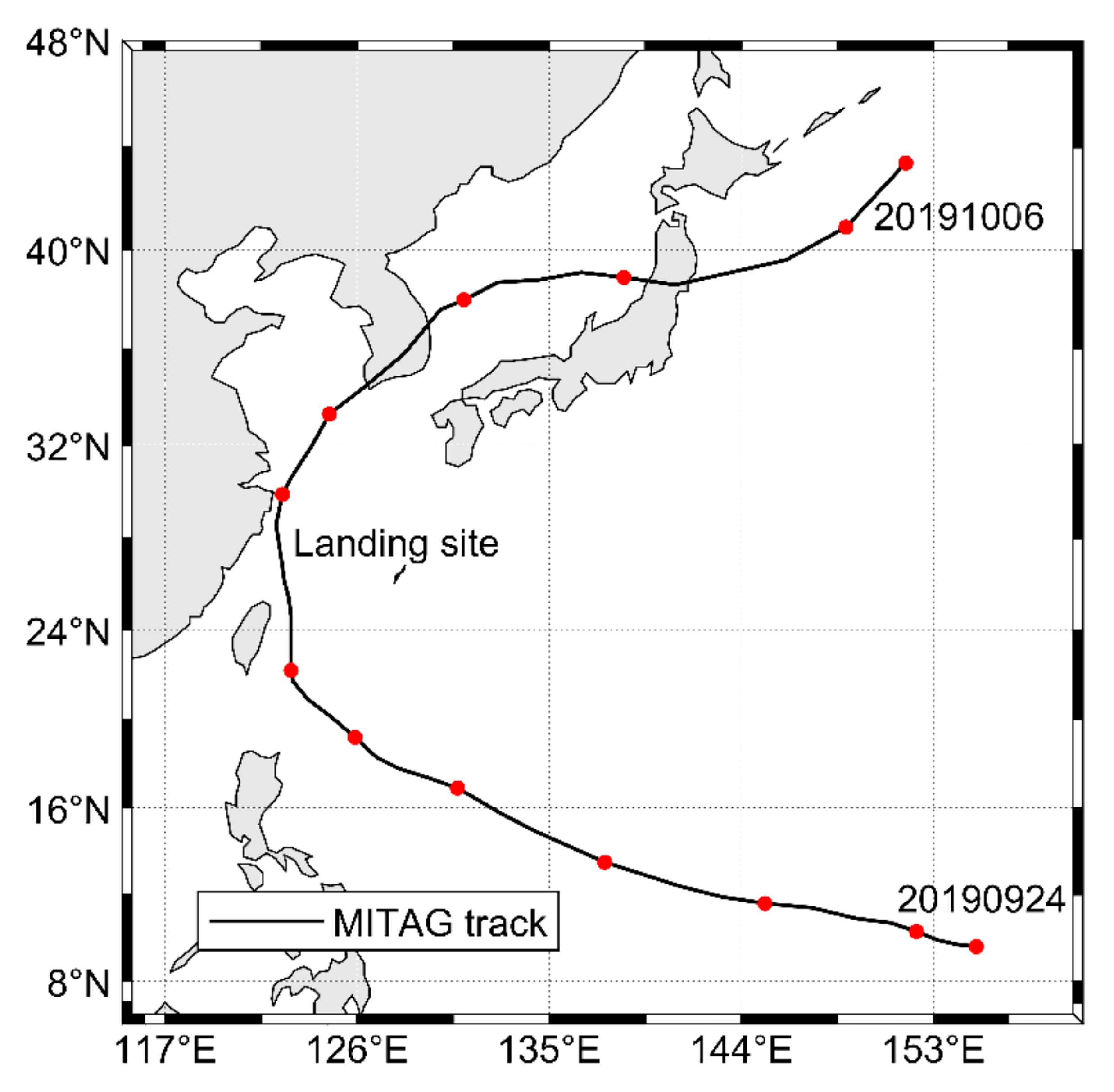
Figure 1. Track of typhoon “MITAG”. (The point is the daily time point, and the black line is the typhoon track).
Atmosphere 12 01027 g001
Figure 2. Study area (a) Northwest Pacific Ocean (b) East China Sea.
Atmosphere 12 01027 g002
Figure 3. Comparison of Typhoon “MITAG” track (RSMC and ERA5).
Atmosphere 12 01027 g003
Figure 4. Significant wave steepness (SWS) and significant wave height (SWH). (Two black dash lines are SWS equals 1/100 and 1/40.)
Atmosphere 12 01027 g004
Figure 5. The wave energy (WE), mean wave period (MWP) and significant wave height (SWH). (M means mix wave, the S means swell, and the W means wind wave.)
Atmosphere 12 01027 g005
Figure 6. Correlation diagram between mean wave period (MWP) and significant wave height (SWH): (a) correlation diagram of wind wave time, from 23:00 on 30 September to 7:00 on 2 October; (b) correlation diagram of SWH and MWP from 5:00 on 29 September to 23:00 on 2 October.
Atmosphere 12 01027 g006
Figure 7. The Ekman pumping velocity distribution at different time. (a) 18:00 on 29 September. (b) 0:00 on 30 September. (c) 12:00 on 01 October. (d) 18:00 on 01 October. (The vectors represent wind, the black line is “MITAG” track, the white circle is center of “MITAG”, and the triangle is the location of Zhoushan buoy.)
Atmosphere 12 01027 g007
Figure 8. (a) The variation in Ekman pumping velocity (EPV) and wind speed (WS) at Zhoushan sea area. (b) The cross-correlation analysis diagram of EPV and WS.
Atmosphere 12 01027 g008
Figure 9. The sea surface current field at 18:00 on 30 September. (The vectors represent currents, the black line is “MITAG” track, the red circle is typhoon center, and the blue triangle is location of Zhoushan buoy.)
Atmosphere 12 01027 g009
Figure 10. The sea surface height (SSH) and currents at a different time. (a) 18:00 on 30 September. (b) 0:00 on 1 October. (c) 18:00 on 1 October. (d) 0:00 on 2 October. (The vectors represent currents, the black line is “MITAG” track, circle is typhoon center, and the triangle is location of Zhoushan buoy.)
Atmosphere 12 01027 g010aAtmosphere 12 01027 g010b
Figure 11. (a) The variation of sea surface current horizontal velocity (HV) and sea surface height (SSH) at Zhoushan sea area. (b) The cross-correlation analysis diagram of SSH and HV.
Atmosphere 12 01027 g011aAtmosphere 12 01027 g011b
Figure 12. Wind speed (WS) and significant wave height (SWH): (a) The variation in wind speed (WS) and significant wave height (SWH); (b) correlation diagram of WS and SWH.
Atmosphere 12 01027 g012
Figure 13. The wind rose during the 29 September to 3 October at the Zhoushan sea area in the special periods: (a) the wind direction (WD) (before 0:00 on 30 September); (b) the WD in swell dominating period (18:00 on 29 September to 14:00 on 30 September); (c) the WD of the period of significant wave height slow increasing (23:00 on 29 September to 20:00 on 30 September); (d) the WD of the period of significant wave height rapidly increasing (20:00 on 30 September to 10:00 on 1 October); (e) the WD in the wind wave dominating period(23:00 on 30 September to the 8:00 on 2 October); (f) the WD from 29 September to 3 October.
Atmosphere 12 01027 g013
Figure 14. The significant wave height of Zhoushan sea area (red contour) at different times. (a) 0:00 on 1 October. (b) 12:00 on 1 October. (c) 18:00 on 01 October. (d) 0:00 on 2 October. (The vectors represent currents, the black line represents “MITAG” track, the red circle is typhoon center, and the triangle is the location of Zhoushan buoy.)
Atmosphere 12 01027 g014aAtmosphere 12 01027 g014b
Figure 15. (a) The variation in significant wave height (SWH) and current variation (CV) at Zhoushan sea area (minus background current field). (b) The cross–correlation analysis diagram of SWH and CV.
Atmosphere 12 01027 g015aAtmosphere 12 01027 g015b
Table 1. The classification of wave with significant wave height.
Wave LevelSignificant Height/mWave LevelSignificant
Height/m
0 (calm—glassy)05 (rough)2.5–4
1 (clam—rippled)0–0.16 (very rough)4–6
2 (smooth wavelet)0.1–0.57 (high)6–9
3 (light)0.5–1.258 (very high)9–14
4 (moderate)1.25–2.59 (phenomenal)>14
Table 2. The joint distribution of significant wave height and mean wave period.
Period(t)/Wave LevelSlightModerateRoughVery Rough
T < 6 s11000
6 s < T < 8 s2216100
8 s < T13649
Publisher’s Note: MDPI stays neutral with regard to jurisdictional claims in published maps and institutional affiliations.