
Time-Spatial Features of Mix El Niño


Abstract
1. Introduction
2. Data and Method
2.1. Data
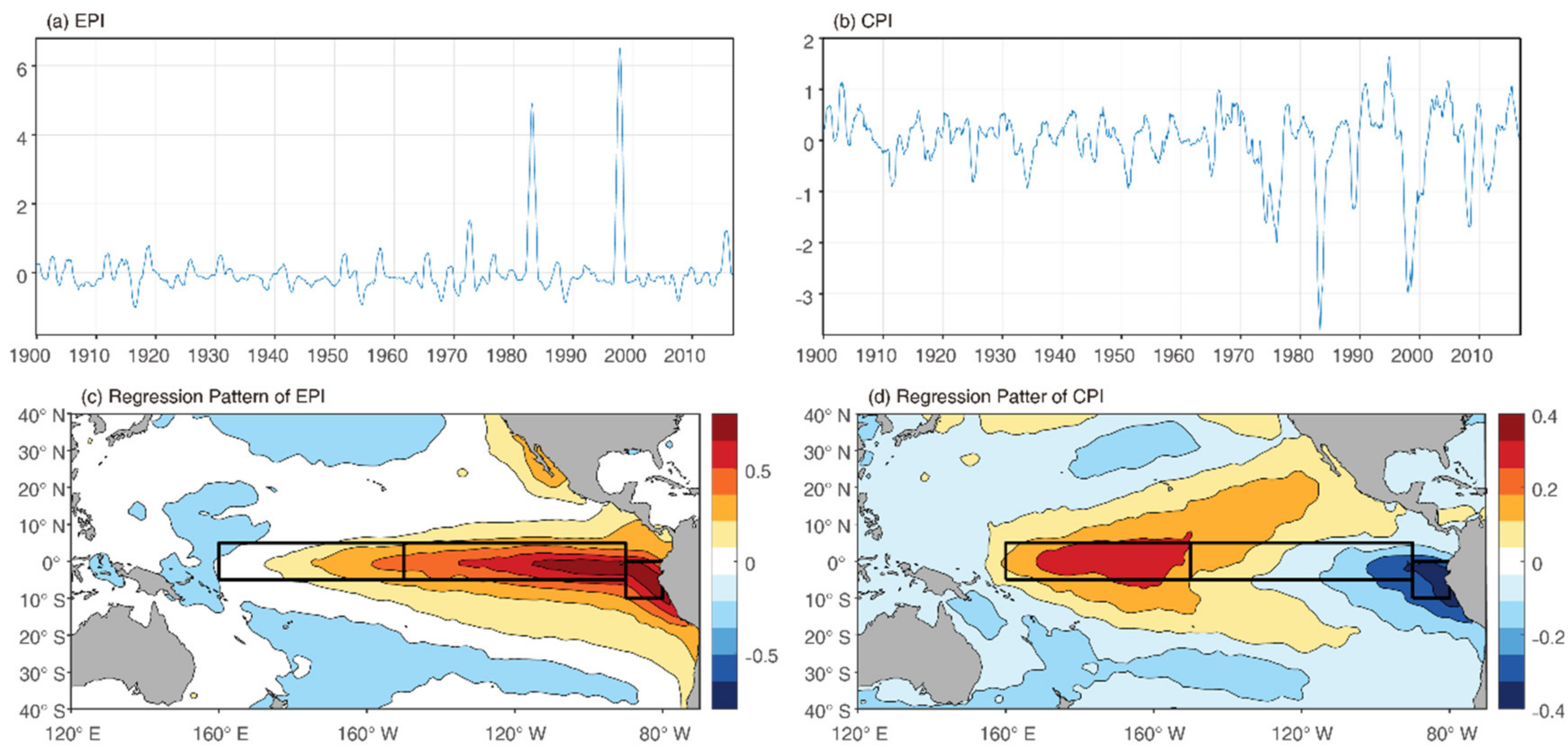
2.2. Index
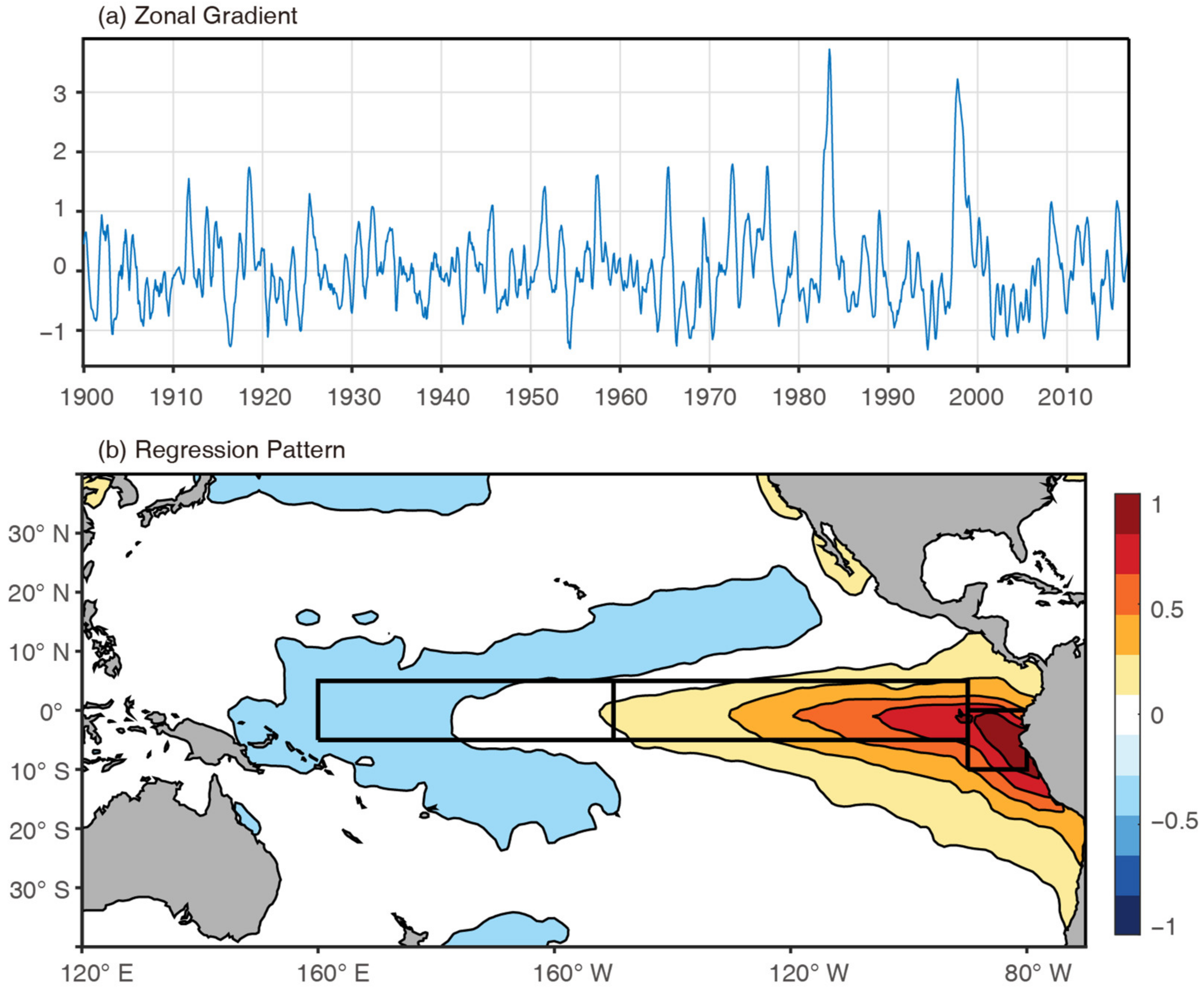
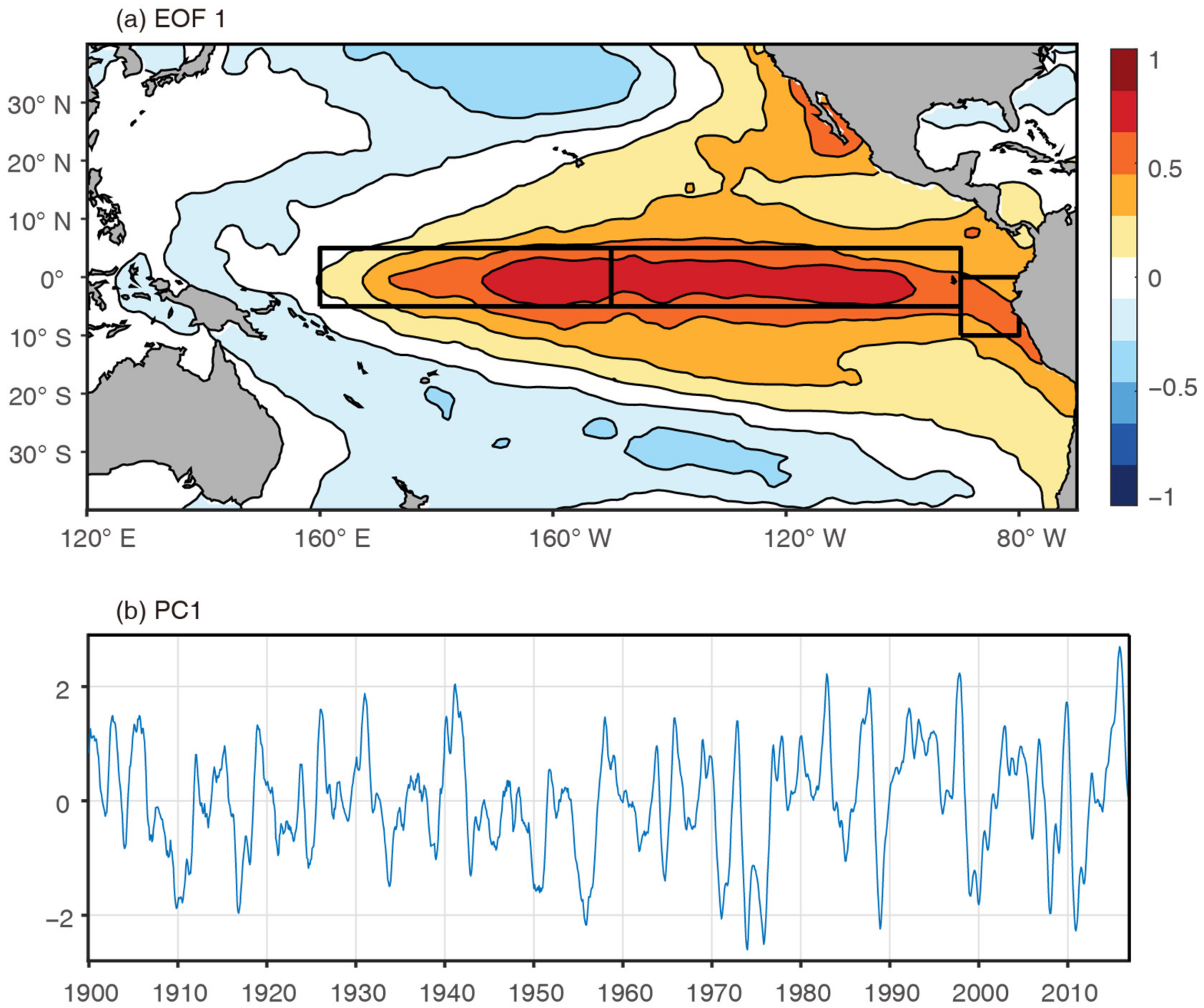
2.3. Regression-EOF
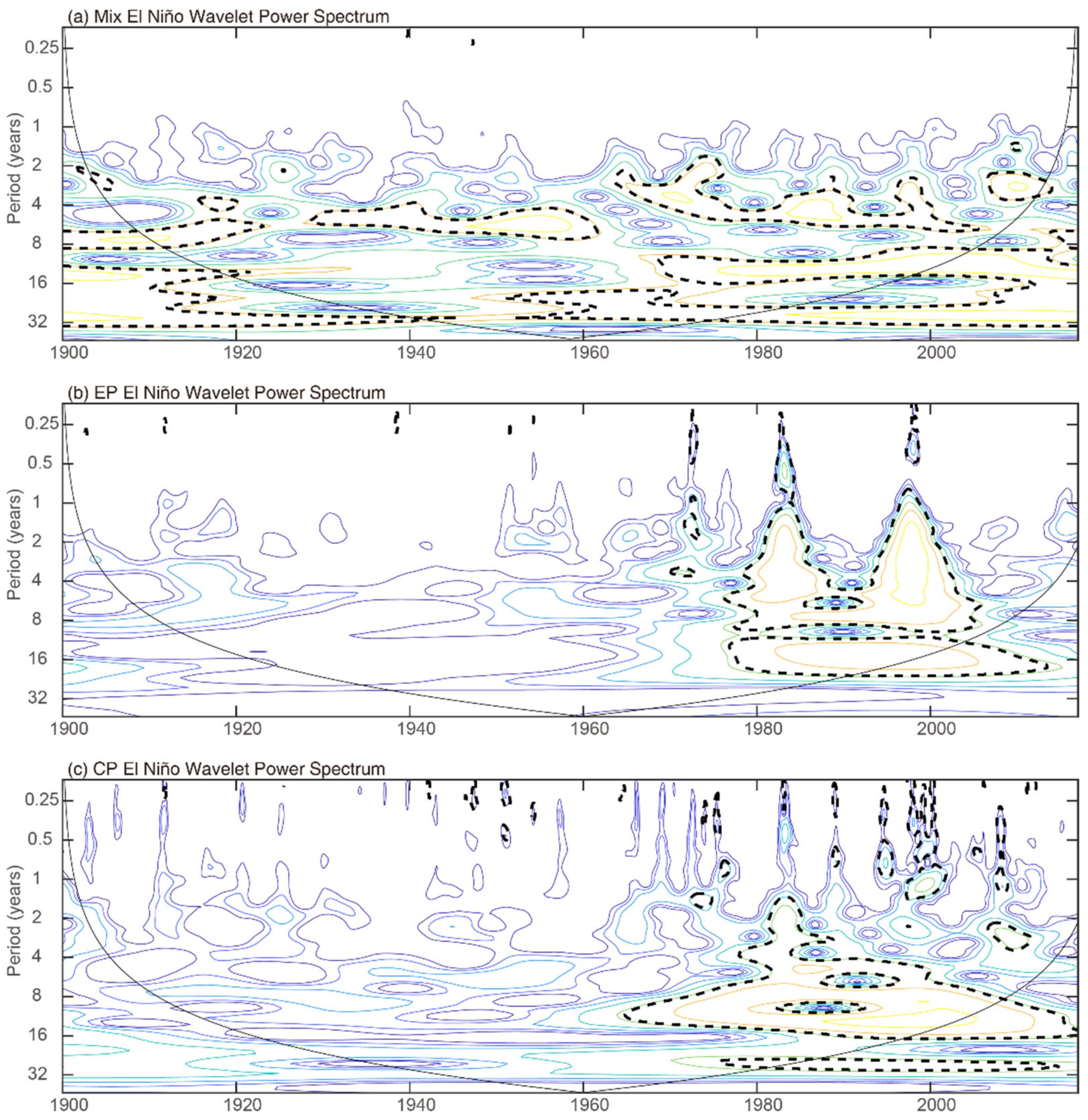
2.4. Wavelet Power Spectrum
3. Mix El Niño Pattern Derived by Regression-EOF Method
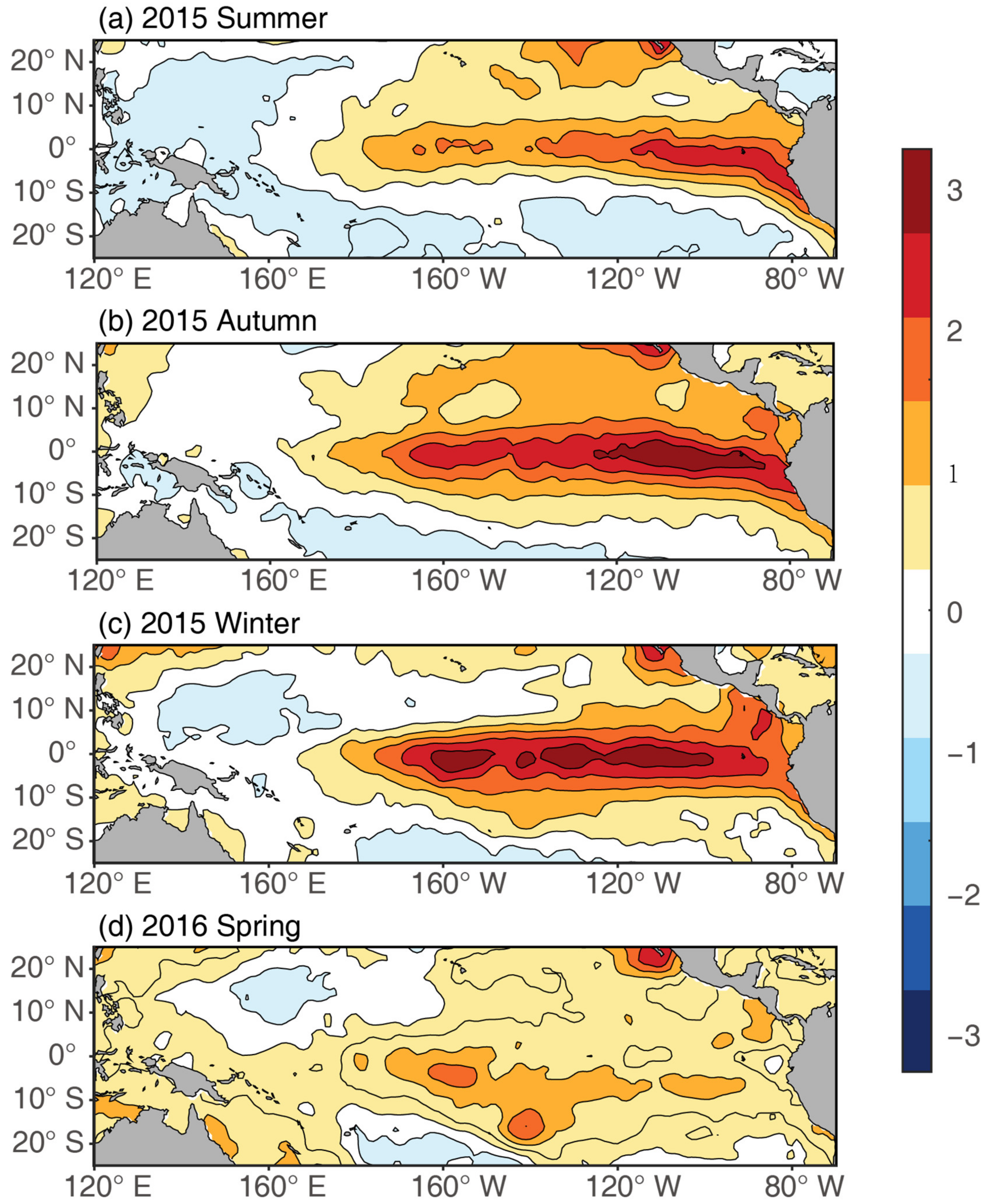
4. Decadal Change of Mix El Niño
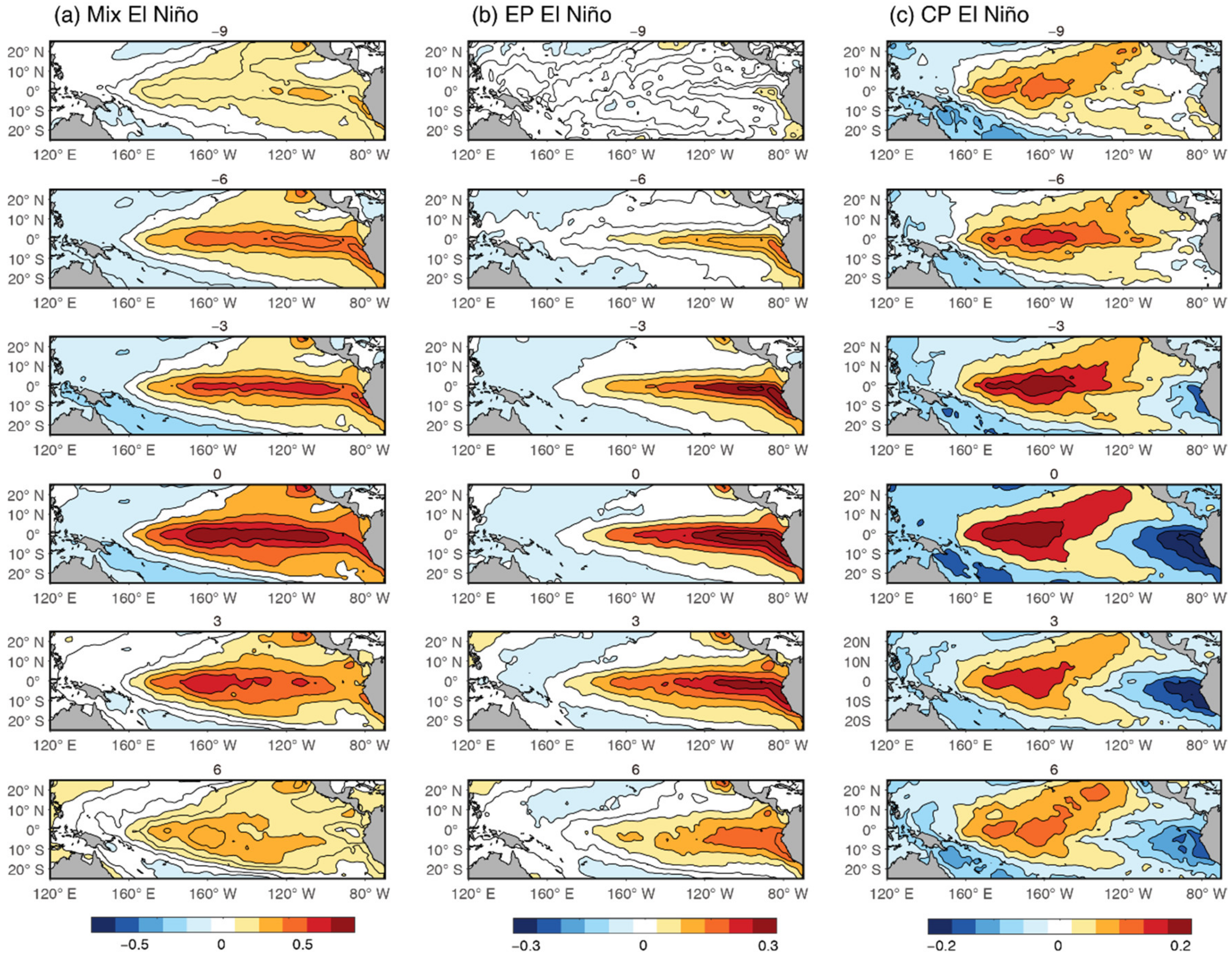
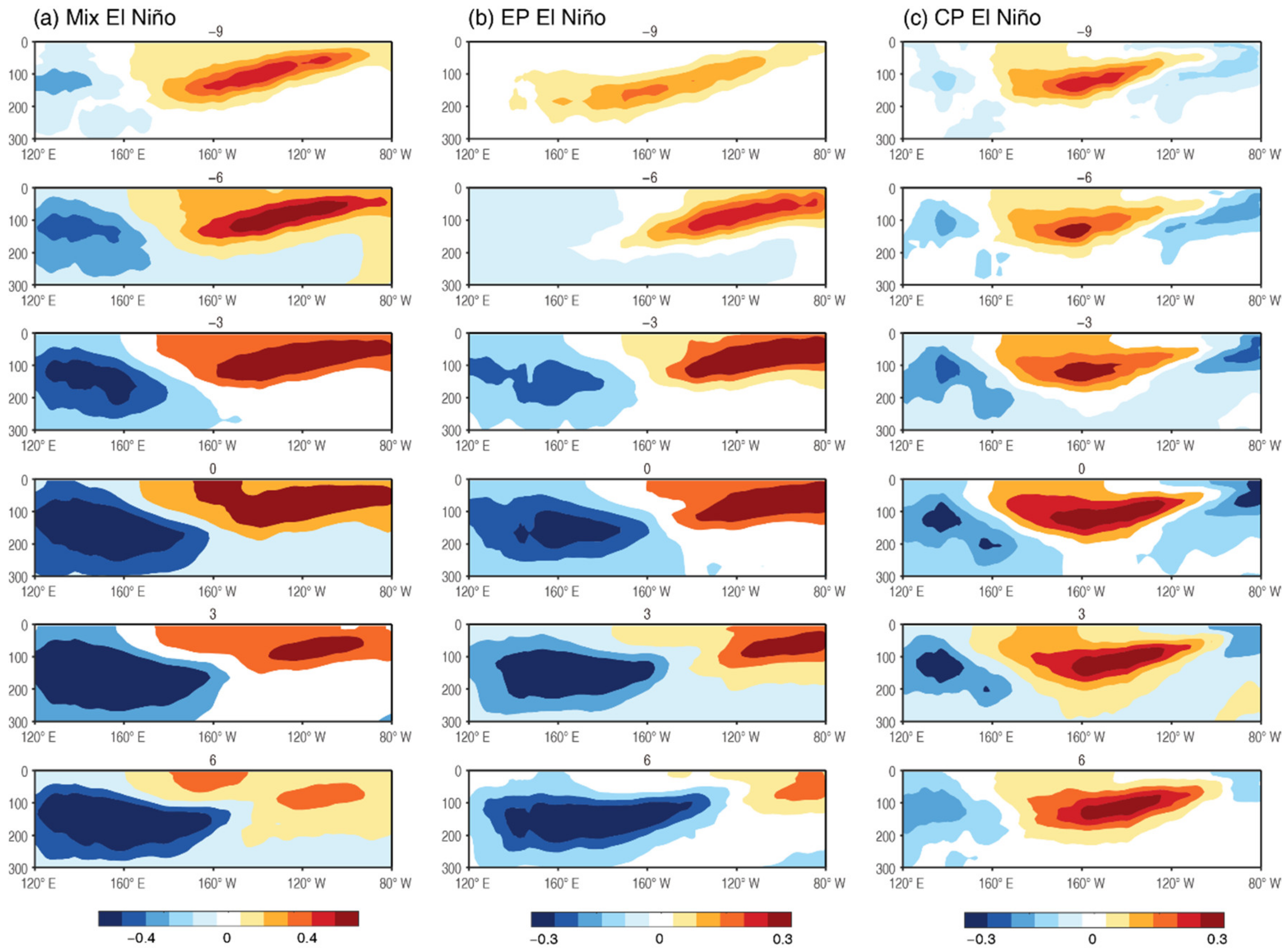
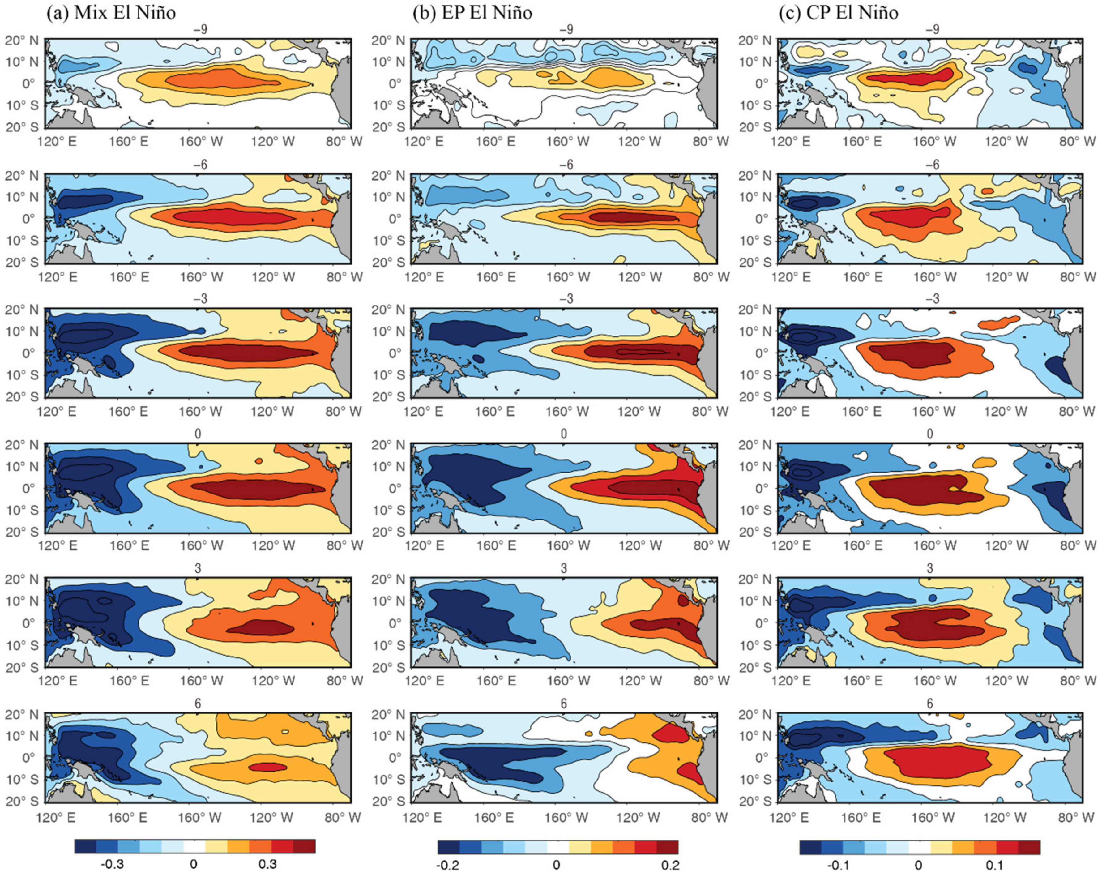
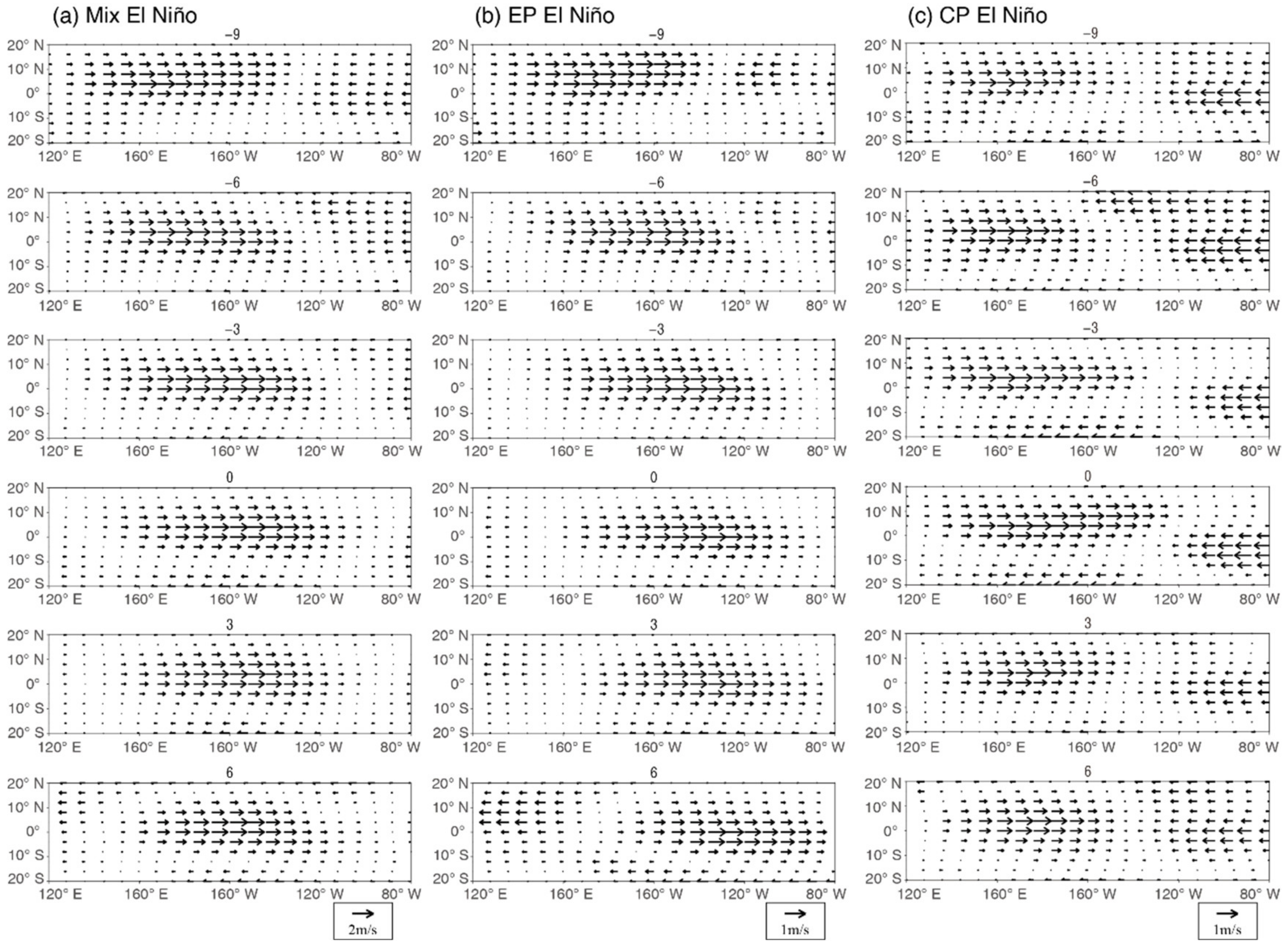
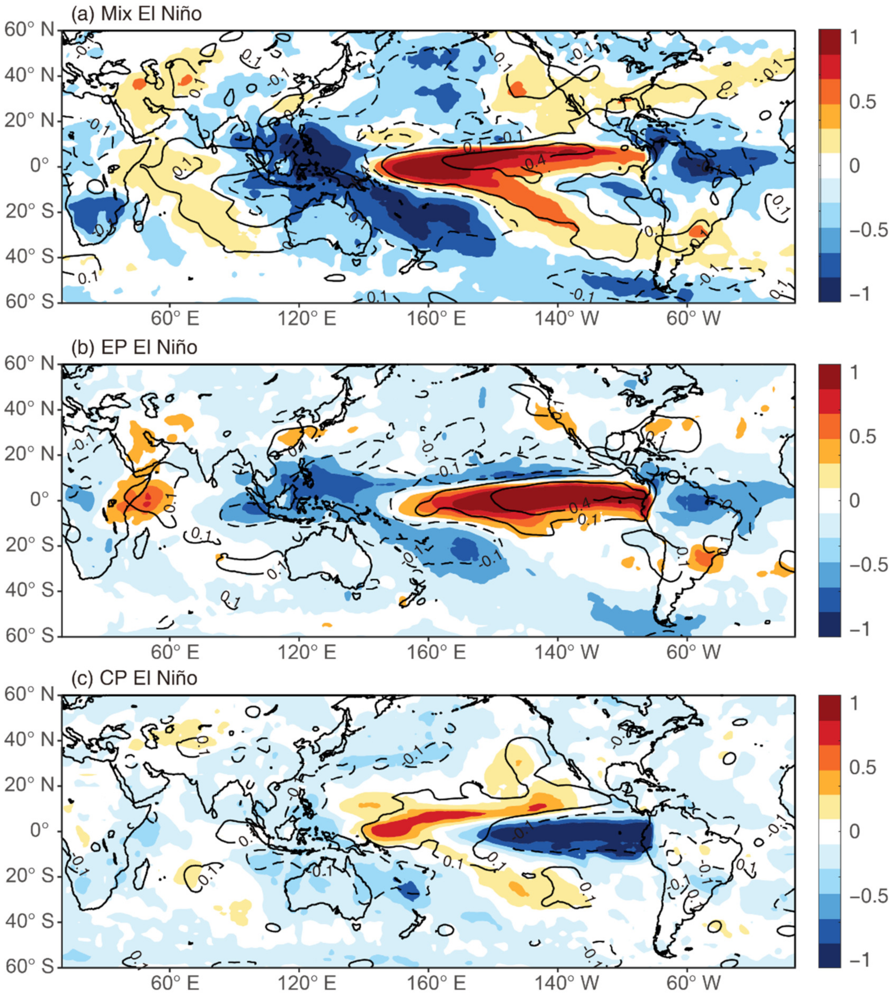
5. Evolution and Ocean–Atmosphere Interaction of Mix El Niño
6. Summary and Discussion
Author Contributions
Funding
Institutional Review Board Statement
Informed Consent Statement
Data Availability Statement
Acknowledgments
Conflicts of Interest
References
- Trenberth, K.E. The Definition of El Niño. Bull. Am. Meteorol. Soc. 1997, 78, 2771–2777. [Google Scholar] [CrossRef]
- Weng, H.; Ashok, K.; Behera, S.K.; Rao, S.A.; Yamagata, T. Impacts of recent El Niño Modoki on dry/wet conditions in the Pacific rim during boreal summer. Clim. Dyn. 2007, 29, 113–129. [Google Scholar] [CrossRef]
- Weng, H.; Behera, S.K.; Yamagata, T. Anomalous winter climate conditions in the Pacific rim during recent El Niño Modoki and El Niño events. Clim. Dyn. 2008, 32, 663–674. [Google Scholar] [CrossRef]
- Ye, C.; Deng, L.; Huang, W.-R.; Chen, J. Comparison of the Madden–Julian Oscillation-Related Tropical Cyclone Genesis over the South China Sea and Western North Pacific under Different El Niño-Southern Oscillation Conditions. Atmosphere 2020, 11, 183. [Google Scholar] [CrossRef]
- Woo, S.H.; Choi, J.; Jeong, J.H. Modulation of ENSO teleconnection on the relationship between arctic oscillation and wintertime temperature variation in south Korea. Atmosphere 2020, 11, 950. [Google Scholar] [CrossRef]
- Rasmusson, E.M.; Carpenter, T.H. Variations in Tropical Sea Surface Temperature and Surface Wind Fields Associated with the Southern Oscillation/El Niño. Mon. Weather Rev. 1982, 110, 354–384. [Google Scholar] [CrossRef]
- Yeh, S.; Kug, J.; Dewitte, B.; Kwon, M.; Kirtman, B.P.; Jin, F.-F. El Niño in a changing climate. Nature 2009, 461, 511–514. [Google Scholar] [CrossRef]
- Trenberth, K.E.; Stepaniak, D.P. Indices of el Niño evolution. J. Clim. 2001, 14, 1697–1701. [Google Scholar] [CrossRef]
- Yu, J.-Y.; Kao, H.-Y. Contrasting Eastern-Pacific and Central-Pacific Types of ENSO. J. Clim. 2009, 22, 615–632. [Google Scholar]
- Jin, F.-F.; Kug, J.-S.; An, S.-I. Two Types of El Niño Events: Cold Tongue El Niño and Warm Pool El Niño. J. Clim. 2009, 22, 1499–1515. [Google Scholar]
- Ashok, K.; Behera, S.K.; Rao, S.A.; Weng, H.; Yamagata, T. El Niño Modoki and its possible teleconnection. J. Geophys. Research 2007, 112, C11007. [Google Scholar] [CrossRef]
- Ren, H.-L.; Jin, F.-F. Niño indices for two types of ENSO. Geophys. Res. Lett. 2011, 38. [Google Scholar] [CrossRef]
- Larkin, N.K.; Harrison, D.E. Global seasonal temperature and precipitation anomalies during El Niño autumn and winter. Geophys. Res. Lett. 2005, 32, L13705. [Google Scholar] [CrossRef]
- Jinshuang, Z.; Yudi, L.; Ruiqing, X.; Haijie, C. A comparative analysis of the impacts of two types of El Niño on the central and eastern Pacific ITCZ. Atmosphere 2018, 9, 266. [Google Scholar]
- Cai, W.; Wu, L.; Lengaigne, M.; Li, T.; McGregor, S.; Kug, J.-S.; Yu, J.-Y.; Stuecker, M.; Santoso, A.; Li, X.; et al. Pantropical climate interactions. Science 2019, 363, eaav4236. [Google Scholar] [CrossRef] [PubMed]
- Liu, Y.; Li, S. North–South Discrepancy of Interannual Sea Surface Temperature Anomalies over the South China Sea Associated with Eastern Pacific El Niño Events in the Spring. Atmosphere 2020, 11, 1135. [Google Scholar] [CrossRef]
- Li, G.; Ren, B.; Yang, C.; Zheng, J. Indices of El Niño and El Niño Modoki: An improved El Niño Modoki index. Adv. Atmos. Sci. 2010, 27, 1210–1220. [Google Scholar] [CrossRef]
- Ashok, K.; Yamagata, T. The El Niño with a difference. Nat. Clim. Chang. 2009, 461, 481–484. [Google Scholar] [CrossRef]
- Marathe, S.; Ashok, K.; Swapna, P.; Sabin, T.P. Revisiting El Niño Modoki. Clim. Chang. 2015, 45, 3527–3545. [Google Scholar] [CrossRef]
- Chen, D.; Lian, T.; Fu, C.; Cane, M.A.; Tang, Y.; Murtugudde, R.; Song, X.; Wu, Q.; Zhou, L. Strong influence of westerly wind bursts on El Niño diversity. Nat. Geosci. 2015, 8, 339–345. [Google Scholar] [CrossRef]
- Yu, J.-Y.; Kim, S.T. Identifying the types of major El Niño events since 1870. Int. J. Climatol. 2013, 33, 2105–2112. [Google Scholar] [CrossRef]
- Zhang, Z.; Ren, B.; Zheng, J. A unified complex index to characterize two types of ENSO simultaneously. Sci. Rep. 2019, 9, 8373. [Google Scholar] [CrossRef]
- Abellán, E.; McGregor, S.; England, M.H.; Santoso, A. Distinctive role of ocean advection anomalies in the development of the extreme 2015–16 El Niño. Clim. Dyn. 2017, 51, 2191–2208. [Google Scholar] [CrossRef]
- Hu, S.; Fedorov, A.V. The extreme El Niño of 2015-2016 and the end of global warming hiatus. Geophys. Res. Lett. 2017, 44, 3816–3824. [Google Scholar] [CrossRef]
- Paek, H.; Yu, J.-Y.; Qian, C. Why were the 2015/2016 and 1997/1998 extreme El Niño different? Geophys. Res. Lett. 2017. [Google Scholar] [CrossRef]
- Santoso, A.; McPhaden, M.J.; Cai, W. The Defining Characteristics of ENSO Extremes and the Strong 2015/2016 El Niño. Rev. Geophys. 2017, 55, 1079–1129. [Google Scholar] [CrossRef]
- Chen, L.; Li, T.; Wang, B.; Wang, L. Formation Mechanism for 2015/16 Super El Niño. Sci. Rep. 2017, 7, 2975. [Google Scholar] [CrossRef] [PubMed]
- Lin, P.; Held, I.; Ming, Y. The Early Development of the 2015/16 Quasi-Biennial Oscillation Disruption. J. Atmos. Sci. 2019, 76, 821–836. [Google Scholar] [CrossRef]
- Zhong, W.; Cai, W.; Zheng, X.T.; Yang, S. Unusual Anomaly Pattern of the 2015/2016 Extreme El Niño Induced by the 2014 Warm Condition. Geophys. Res. Lett. 2019, 46, 14772–14781. [Google Scholar] [CrossRef]
- Wu, Y.K.; Hong, C.C.; Chen, C.T. Distinct Effects of the Two Strong El Niño Events in 2015–2016 and 1997–1998 on the Western North Pacific Monsoon and Tropical Cyclone Activity: Role of Subtropical Eastern North Pacific Warm SSTA. J. Geophys. Res. Oceans 2018, 123, 3603–3618. [Google Scholar] [CrossRef]
- Kim, H.-M.; Webster, P.J.; Curry, J.A. Impact of shifting patterns of Pacific Ocean warming on North Atlantic tropical cyclones. Science 2009, 325, 77–80. [Google Scholar] [CrossRef] [PubMed]
- Rayner, N.A.; Parker, D.E.; Horton, E.B.; Folland, C.K.; Alexander, L.V.; Rowell, D.P.; Kent, E.C.; Kaplan, A. Global analyses of sea surface temperature, sea ice, and night marine air temperature since the late nineteenth century. J. Geophys. Res. 2003, 108, 4407. [Google Scholar] [CrossRef]
- Good, S.A.; Martin, M.J.; Rayner, N.A. EN4: Quality controlled ocean temperature and salinity profiles and monthly objective analyses with uncertainty estimates. J. Geophys. Res. Oceans 2013, 118, 6704–6716. [Google Scholar] [CrossRef]
- Kistler, R.; Kalnay, E.; Collins, W.; Saha, S.; White, G.; Woollen, J.; Chelliah, M.; Ebisuzaki, W.; Kanamitsu, M.; Kousky, V.; et al. The NCEP-NCAR 50-Year Reanalysis: Monthly Means CD-ROM and Documentation. Bull. Am. Meteor. Soc. 2001, 82, 247–268. [Google Scholar] [CrossRef]
- National Center for Atmospheric Research Staff (Ed.) The Climate Data Guide: NOAA 20th-Century Reanalysis, Version 2 and 2c. Last Modified 12 December 2019. Available online: https://climatedataguide.ucar.edu/climate-data/noaa-20th-century-reanalysis-version-2-and-2c (accessed on 7 April 2021).
- Adler, R.F.; Huffman, G.J.; Chang, A.; Ferraro, R.; Xie, P.; Janowiak, J.; Rudolf, B.; Schneider, U.; Curtis, S.; Bolvin, D.; et al. The Version 2 Global Precipitation Climatology Project (GPCP) Monthly Precipitation Analysis (1979-Present). J. Hydrometeor. 2003, 4, 1147–1167. [Google Scholar] [CrossRef]
- Li, G.; Ren, B.-H.; Yang, C.-Y. Traditional El Niño and El Niño Modoki revisited: Is El Niño Modoki linearly independent of traditional El Niño? Atmos. Ocean. Sci. Lett. 2010. [Google Scholar] [CrossRef]
- Yu, J.Y.; Kao, H.Y.; Lee, T.; Kim, S.T. Subsurface ocean temperature indices for central-pacific and eastern-pacific types of El Niño and La Nina events. Theor. Appl. Climatol. 2011, 103, 337–344. [Google Scholar] [CrossRef]
- Chelton, D.B.; Schlax, M.G. Global observations of oceanic Rossby waves. Science 1996, 292, 234. [Google Scholar] [CrossRef]
- Bjerknes, J.A. Atmospheric teleconnections from the equatorial pacific. Mon. Weather Rev. 1969, 97, 163–172. [Google Scholar] [CrossRef]
- Cai, W.; Wang, G.; Santoso, A. Stronger Increase in the Frequency of Extreme Convective than Extreme Warm El Niño Events under Greenhouse Warming. J. Clim. 2020, 33, 675–690. [Google Scholar]
- Ren, H.L.; Wang, R.; Zhai, P.; Ding, Y.; Lu, B. Upper-ocean dynamical features and prediction of the super El Niño in 2015/16: A comparison with the cases in 1982/83 and 1997/98. J. Meteorol. Res. 2017, 31, 278–294. [Google Scholar] [CrossRef]
- Li, G.; Gao, C.; Lu, B.; Chen, H. Inter-annual variability of spring precipitation over the Indo-China Peninsula and its asymmetric relationship with El Niño-Southern Oscillation. Clim. Dyn. 2021. [Google Scholar] [CrossRef]
- Li, G.; Du, Y.; Xu, H.; Ren, B. An Intermodel Approach to Identify the Source of Excessive Equatorial Pacific Cold Tongue in CMIP5 Models and Uncertainty in Observational Datasets. J. Clim. 2015, 28, 7630–7640. [Google Scholar] [CrossRef]
- Li, G.; Jian, Y.; Yang, S.; Du, Y.; Wang, Z.; Li, Z.; Zhuang, W.; Jiang, W.; Huang, G. Effect of excessive equatorial Pacific cold tongue bias on the El Niño-Northwest Pacific summer monsoon relationship in CMIP5 multimodel ensemble. Clim. Dyn. 2019, 52, 6195–6212. [Google Scholar] [CrossRef]
- Li, G.; Xie, S.-P.; Du, Y.; Luo, Y. Effect of excessive equatorial cold tongue bias on the projections of the tropical Pacific climate change. Part I: The warming pattern in CMIP5 multi-model ensemble. Clim. Dyn. 2016, 47, 3817–3831. [Google Scholar] [CrossRef]
- Li, G.; Xie, S.-P.; He, C.; Chen, Z. Western Pacific emergent constraint lowers projected increase in Indian summer monsoon rainfall. Nat. Clim. Chang. 2017, 7, 708–712. [Google Scholar] [CrossRef]
- Banholzer, S.; Donner, S. The influence of different El Niño types on global average temperature. Geophys. Res. Lett. 2014, 41, 2093–2099. [Google Scholar] [CrossRef]
- Zhang, W.; Wang, Y.; Jin, F.-F.; Stuecker, M.F.; Turner, A.G. Impact of different El Niño types on the El Niño/IOD relationship. Geophys. Res. Lett. 2015, 42, 8570–8576. [Google Scholar] [CrossRef]
- Andreoli, R.V.; Oliveira, S.; Kayano, M.T.; Viegas, J.; Souza, R.A.F.D.; Candido, L.A. The influence of different El Niño types on the south American rainfall. Int. J. Climatol. 2016, 37. [Google Scholar] [CrossRef]
- Yuan, Y.; Yang, H.; Li, C. Study of El Niño events of different types and their potential impact on the following summer precipitation in China. Acta Meteorol. Sin. 2012, 70, 467–478. [Google Scholar]


| Dataset Name | Coverage | Download Website |
|---|---|---|
| Hadley Centre Sea Ice and Sea Surface Temperature dataset (HadISST) [32] | 1° × 1° horizontal resolution 1870–present | https://www.metoffice.gov.uk/hadobs/hadisst/ |
| EN4: quality controlled subsurface ocean temperature and salinity profiles and objective analyses (version 4.2.1) from the Met Office Hadley Centre observation datasets [33] | 1° × 1° horizontal resolution and 42 (20) levels from subsurface depth 5 M to 5350 M (315 M) 1900–present | https://www.metoffice.gov.uk/hadobs/en4/download-en4-2-1.html |
| Reanalysis Data NCEP monthly pressure u-wind and vertical wind [34] | 2.5° × 2.5° horizontal resolution and 10 vertical levels from 1000 to 200 hPa 1948–present | https://psl.noaa.gov/data/gridded/data.ncep.reanalysis.pressure.html |
| Monthly NOAA-CIRES 20th Century Reanalysis V2c [35] | 2° × 2° horizontal resolution and 24 vertical levels from 1000 to 10 hPa 1851–2014 | https://psl.noaa.gov/data/gridded/data.20thC_ReanV2c.html |
| GPCP Version 2.3 Combined Precipitation Dataset [36] | 2.5° × 2.5° horizontal resolution 1979–present | https://psl.noaa.gov/data/gridded/data.gpcp.html |
| Index Name | Definition | Brief Description |
|---|---|---|
| NINO1 + 2 | Area-averaged SSTA over (90° W-80° W, 10° S-0°) | Well-known El Niño indices, but cannot well distinguish different types of El Niño. |
| NINO3 | Area-averaged SSTA over (150° W-90° W, 5° S-5° N) | |
| NINO4 | Area-averaged SSTA over (160° E-150° W, 5° S-5° N) | |
| NINO3.4 | Area-averaged SSTA over (170° W-120° W, 5° S-5° N) | |
| Trans-Niño index (TNI) [8] | An index representing the zonal SSTA gradient in central-eastern Pacific region | |
| El Niño Modoki index (EMI) [11] | The brackets represent the area-averaged SSTA over the region A (165° E–140° W, 10° S–10° N), B (110° W–70° W, 15° S–5° N), and C (125° E–145° E, 10° S–20° N), respectively. | An index that is built based on the zonal tripolar structure of central Pacific (CP) El Niño pattern derived by the EOF method. |
| Improved El Niño Modoki index (IEMI) [37] | An improved index of EMI by adjusting the proportion of three items in EMI. | |
| Niño index for Cold Tongue/Warm Pool El Niño (NCT/NWP) [12] | where α equals 0.4 when NINO3*NINO4 > 0, otherwise equals 0. | A pair of El Niño index that is built based on the features of NINO3 and NINO4 during eastern Pacific (EP) and CP El Niño. |
| EP/CP El Niño Subsurface index (EPSI/CPSI) [38] | Area-averaged SSTA of (90° W-80° W, 5° S-5° N, upper 100 m)/(160° E-150° W, 5° S-5° N, upper 100 m) | EP and CP El Niño indices based on the subsurface ocean temperature anomalies. |
| Unified Complex El Niño index (UCEI) [22] | the r represents the strength of El Niño while the θ is used to determine the type of El Niño as follows: | A complex index characterizing EP, CP, and Mix El Niño unifiedly, good at classification of three types of El Niño but not convenient for some statistical analysis such as lead-lag correlation. |
Publisher’s Note: MDPI stays neutral with regard to jurisdictional claims in published maps and institutional affiliations. |
© 2021 by the authors. Licensee MDPI, Basel, Switzerland. This article is an open access article distributed under the terms and conditions of the Creative Commons Attribution (CC BY) license (https://creativecommons.org/licenses/by/4.0/).
Share and Cite
Zhang, Z.; Li, G. Time-Spatial Features of Mix El Niño. Atmosphere 2021, 12, 476. https://doi.org/10.3390/atmos12040476
Zhang Z, Li G. Time-Spatial Features of Mix El Niño. Atmosphere. 2021; 12(4):476. https://doi.org/10.3390/atmos12040476
Chicago/Turabian StyleZhang, Zhiyuan, and Gen Li. 2021. "Time-Spatial Features of Mix El Niño" Atmosphere 12, no. 4: 476. https://doi.org/10.3390/atmos12040476
APA StyleZhang, Z., & Li, G. (2021). Time-Spatial Features of Mix El Niño. Atmosphere, 12(4), 476. https://doi.org/10.3390/atmos12040476