Article

The Impact of a Hydroelectric Power Plant on a Regional Climate in Portugal

Centre for the Research and Technology of Agro-Environmental and Biological Sciences (CITAB), Inov4Agro–Institute for Innovation, Capacity Building and Sustainability of Agri-Food Production, University of Trás-os-Montes and Alto Douro, 5000-801 Vila Real, Portugal
*
Author to whom correspondence should be addressed.
Atmosphere 2021, 12(11), 1400; https://doi.org/10.3390/atmos12111400
Submission received: 10 September 2021 / Revised: 19 October 2021 / Accepted: 22 October 2021 / Published: 26 October 2021
(This article belongs to the Section Climatology)

Abstract

:
This paper summarizes the results from microclimatic monitoring of the impacts related to the construction and exploration phase of a hydroelectric powerplant in the upper Douro River (Portugal). Reference climatic elements for both periods were obtained and the impacts of the reservoir water mass on the region’s microclimate were evaluated. For this purpose, Sen’s slope estimate non-parametric test was used to detect the meteorological variables’ trends over 10 years, considering the division into the construction (2011–2015) and exploration (2016–2020) phases. A network of meteorological stations located close to the dam, in addition to a control station relatively distant from the dam, was used to collect the meteorological data. The control station is still integrated into the same regional climatic context but not exposed to the direct influence of the resulting reservoirs. As a result, temporal differences were determined for temperature and relative humidity. The results show a statistically significant increase in the minimum relative humidity, accompanied by a statistically significant decrease in the daily and seasonal temperature amplitudes between the construction and the exploration phase periods. These outcomes thereby suggest that large reservoirs affect the local climate and may create new microclimates, in the surrounding area, with both positive and negative potential effects.

1. Introduction

The construction of dams for hydroelectric power generation is critical for providing renewable energy sources, thus replacing fossil fuel consumption and mitigating greenhouse gas emissions to the atmosphere, which is a key strategy to combat climate change [1,2,3]. This is particularly relevant taking into account the leading role played by the energy sector in the anthropogenic radiative forcing since the pre-industrial era [4,5]. The construction of dams usually leads to changes in land cover with the increase in irrigated agricultural areas resulting from arable land, which in turn provide raw materials for industries [6]. In addition to the production of energy, they also mitigate floods and enable an increase in populated areas in the downstream regions [7].
Nevertheless, the damming of rivers represents one of the broadest human alterations of water flow from land to sea, substantially affecting ecological, sociocultural and, economic aspects in the surrounding area [6]. Furthermore, coupling high-resolution meteorological data [8,9] with calibrated and validated hydrological models is an important tool to determine the water quantity [10,11,12,13,14] and quality [15,16,17,18,19] of a basin, to investigate the hydroelectric potential it may deliver. In effect, although dams provide the above-mentioned benefits, they may affect the environment through damage to ecosystems [20,21,22] or changes in the local climate. The change of vegetated or bare land into a water body leads to noteworthy changes in surface albedo and thus alters the surrounding heat balance [7]. Such changes can significantly impact atmospheric mesoscale circulation (10–100 km) due to the increase in local moisture [23,24]. Thus, a gradual change is expected in the local climate in the surrounding area of the artificial reservoir [25]. Several studies have been undertaken of climate change impacts on dam reservoirs (e.g., water resources, water quality, and siltation) [26,27,28,29,30,31,32,33]. However, by comparison, the impact of a dam reservoir on the local climate has not been significantly explored. Research studies regarding the negative and positive impacts of dams on the environment also report impacts on both local and regional climates [25,34,35,36,37]. These studies report increased rates of humidity and decreases in temperature amplitudes in the surrounding area of the artificial reservoirs, with insignificant variation in precipitation values, which become less pronounced as distance increases from the reservoirs. Furthermore, the influence is more noticeable in Mediterranean and semi-arid climates than in humid climates [25]. For Portugal, there is no research of the impact of a reservoir on the local climate. Studies normally assess the impact on aquatic and riparian plants [38] or biodiversity loss [39,40].
The present study aimed to determine the extent of the impacts of a hydroelectric powerplant (artificial reservoir) on a local Mediterranean-type climate, under the Integrated Environmental Monitoring Program (PIMA—Programa Integrado de Monitorização Ambiental) of the Baixo Sabor Hydroelectric Plant (BSHP) (upper Douro River), Portugal.

2. Materials and Methods

2.1. Study Area

The Baixo Sabor Hydroelectric Plant (BSHP) is located in northeastern Portugal, close to the Portuguese–Spanish border (Figure 1), and more precisely on the lower section of the Sabor River, which is the first tributary on the right bank of the Douro/Duero River in the Portuguese territory. The Sabor River has its spring in the “Serra de Parada”, in Spain, at an altitude of about 1600 m, flowing into the Douro River downstream of “Pocinho”, at an altitude of 97 m. Approximately 86% of the basin is located in Portuguese territory. The BSHP is made up of two dams located on the lower section of the Sabor River. The upstream dam (Upper Sabor dam) is located approximately 12.6 km from the confluence of the Sabor River with the Douro River, and the other, downstream, dam (Lower Sabor dam), which performs compensatory functions, is located 3 km from the Sabor River mouth. Its implementation resulted in the creation of two reservoirs. The main reservoir extends 60 km upstream of the course of the Sabor River and has a full storage level of 234 m, occupying areas of the Municipalities of “Torre de Moncorvo”, “Alfândega da Fé”, “Mogadouro”, and “Macedo de Cavaleiros”, with a total area of 2800 ha. The second reservoir, between the two dams, whose full storage level is 138 m, occupies an area of 200 ha of the Municipality of “Torre de Moncorvo”. The construction of the BSHP was undertaken between 2006 and 2010, the completion of the reservoir filling phase was in 2015, and the exploitation phase started in 2016, continuing until the present. The target region is characterized by a warm and dry Mediterranean-type climate [41,42]. According to the Worldwide Bioclimatic Classification System (WBCS), the macro-bioclimate is characterized by Mediterranean pluviseason oceanic (bioclimate), upper sub-humid and lower humid (ombroclimate), and upper meso-mediterranean (thermoclimate) horizons [43].

2.2. Meteorological Network Stations

Since 2010, when the BSHP was still under construction, a systematic collection of local meteorological data has been carried out. For data collection, a meteorological network of twelve automatic stations (with wireless communication) was installed in the area surrounding the hydroelectric power plant (Table 1). Data was recorded by three automatic weather stations (AWS)—Póvoa, Felgar, and Sardão—and by a set of six thermohygrometric (temperature and relative humidity sensors) automatic stations (TH) currently in operation (Adeganha, Castedo, Meirinhos, Sendim, Picões, and Castelo Branco). The THs of Ferrominas, Alvazinhos, and Maçores were damaged and not replaced (Figure 1b). The THs record only air temperature (T, in °C) and relative humidity (RH, in %), whereas the AWS record T and RH, in addition to precipitation (P, in mm), wind speed (WS, in m s−1) and direction (WD, in °), solar radiation flux (SR, in W m−2), and soil temperature (ST, in °C). The sampling of meteorological parameters is carried out continuously. The records of the various sensors are automatically read every 10 s (reading interval), both for AWS and TH. However, the values are compiled and digitally recorded in tables with a periodicity of 10 min (AWS and TH), 60 min (AWS), and 24 h (AWS and TH). Data collection from the various stations is carried out via the Global System for Mobile Communications (GSM), or locally when remote communications are not operational. The network is regularly maintained. The specifications of each sensor can be found in the Supplementary Material (Table S1).
The planning of the location of the stations took into account the complex orography and physiography of the region, complemented by a high diversity of soils, from schist to granite. Additionally, the chosen locations would allow for proper measurement of the wind variable. It was also intended that the stations be located at a sufficiently close distance from the reservoir. This approach also makes it possible to significantly cover the area of artificial lakes resulting from the filling of the reservoirs. Furthermore, the recommendations of the World Meteorological Organization for the installation of weather stations were followed [44], ensuring the quality of the recorded data. The planning and location of the network of meteorological stations at the BSHP were also approved by the Portuguese Institute for the Sea and the Atmosphere (IPMA).
Table 1. Network stations (EPSG: 4230), along with their geographical coordinates (latitude and longitude), elevation, and recorded meteorological parameters.
Station NameLatitude
(°N)
Longitude (°W)Elevation
(m amsl)
Parameters *
AWS Póvoa41.237.03466T/RH/P/WS/WD/SR/ST
AWS Felgar41.226.97457T/RH/P/WS/WD/SR/ST
AWS Sardão41.276.89321T/RH/P/WS/WD/SR/ST
TH Ferrominas41.186.96704T/RH
TH Maçores41.136.99658T/RH
TH Adeganha41.237.06485T/RH
TH Castedo41.237.16609T/RH
TH Meirinhos41.276.84506T/RH
TH Alvazinhos41.376.79593T/RH
TH Sendim41.306.98481T/RH
TH Picões41.256.95437T/RH
TH Castelo Branco41.276.76580T/RH
* Key: T: temperature; RH: relative humidity; P: precipitation; WS: wind speed; WD: wind direction; SR: solar radiation flux; ST: soil temperature.

2.3. Validation of Collected Data

Concerning data processing, a descriptive statistical analysis of the variables and verification of the homogeneity of the series was carried out to ensure the reliability of the study, and that the different time series contained no errors (e.g., instrumentals). Thus, data validation took into account the following criteria: (1) verification of physical limits and instrumental limits; and (2) monthly data verification routines for each station, to validate and prepare the 10 min records that comprise the database. Daily data with a volume of failures greater than 10% of the total data for that day were excluded from the analysis. The missing data was calculated based on linear regressions with the other existing meteorological stations in the study area.

2.4. Control Meteorological Station

Because climate variability may have multiple natural and anthropogenic causes, which manifest themselves over a wide spectrum of spatial and temporal scales, not all regional climate changes can be attributed to the BSHP. These changes must be distinguished from changes attributable to the BSHP itself, which are necessarily limited to the local and regional scale. Therefore, a comparison of the recorded data in the present network of stations against the observations of a meteorological station far enough from the BSHP, i.e., not exposed to its influence but still integrated into the same regional climatic context, was carried out. For this reason, we compared the meteorological records of Baixo Sabor with the reference AWS of Vila Real (Figure 1). In this manner, it was possible to disaggregate the possible effects of the BSHP on the surrounding mesoclimate from other causes, namely, natural trends and/or ongoing large-scale climate change. This reference AWS is maintained at the campus of the University of “Trás-os-Montes e Alto Douro” in Vila Real, and similar quality checking procedures as for the BSHP meteorological network were applied. Furthermore, a comparison between the Vila Real and Bragança AWS (Table S2) was carried out to exclude the effect of local climate influences of the control station (Figure S1) for a period of 76 years (1941–2016). The data for the entire period for the AWS of Bragança were retrieved from the European Climate Assessment & Dataset project [45].
The anomalies (differences) between the AWS from the BS and the reference AWS were computed to highlight background trends due to the BSHP. For this purpose, a trend analysis was undertaken to identify statistically significant trends in the different meteorological variables. Because the filling of the dams was gradual over time, and took place at an irregular rate due to the local Mediterranean-type climate conditions, it was not possible to discriminate between pre-dam and post-dam periods. Hence, the trend analysis was based on linear regression trends, which is the simplest approach. However, this analysis was complemented by the calculation of Sen’s slope estimator [46], which is a non-parametric statistically robust measure of trends. In addition, the Spearman Rho [47] test was undertaken to further assess the trends of the anomalies for temperature and relative humidity.

3. Results and Discussion

3.1. Climate Characterization
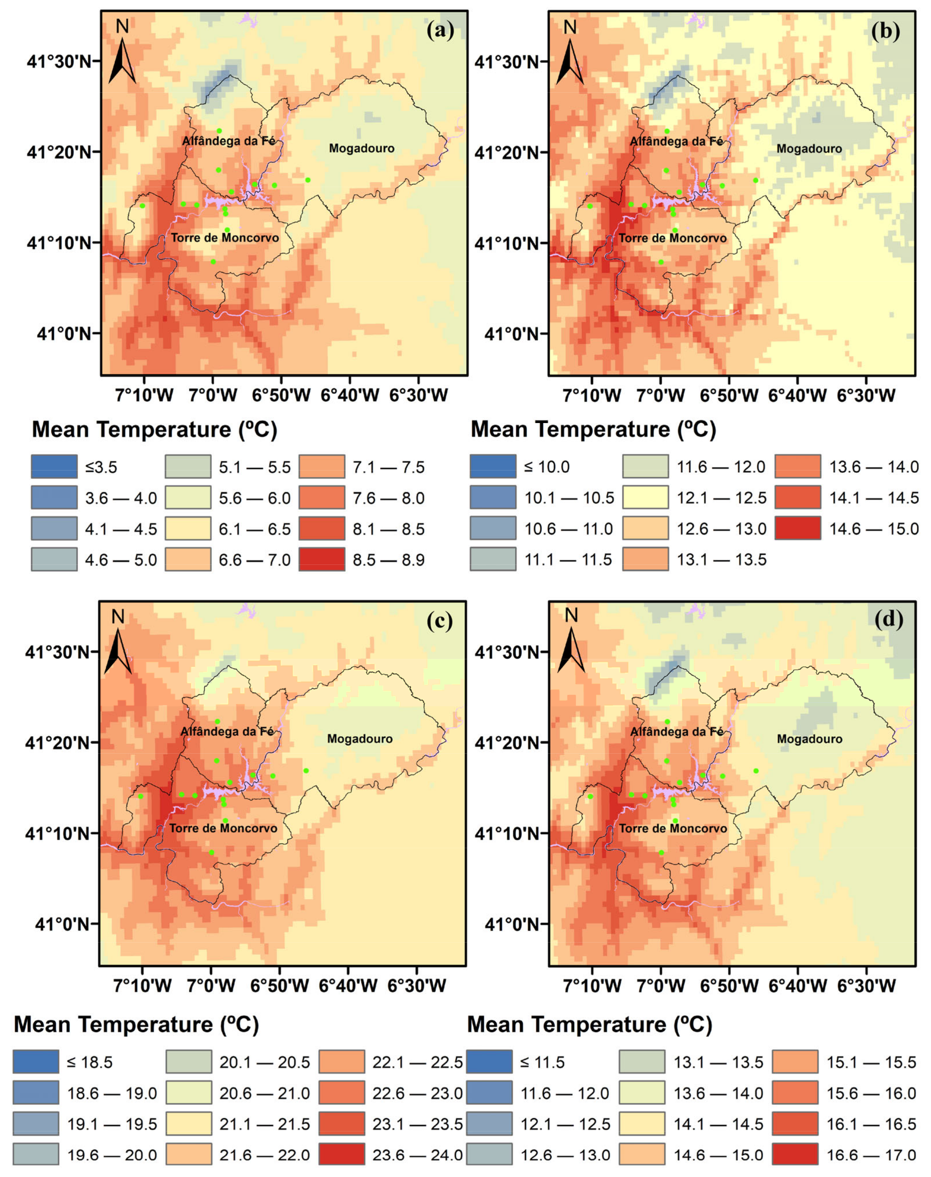
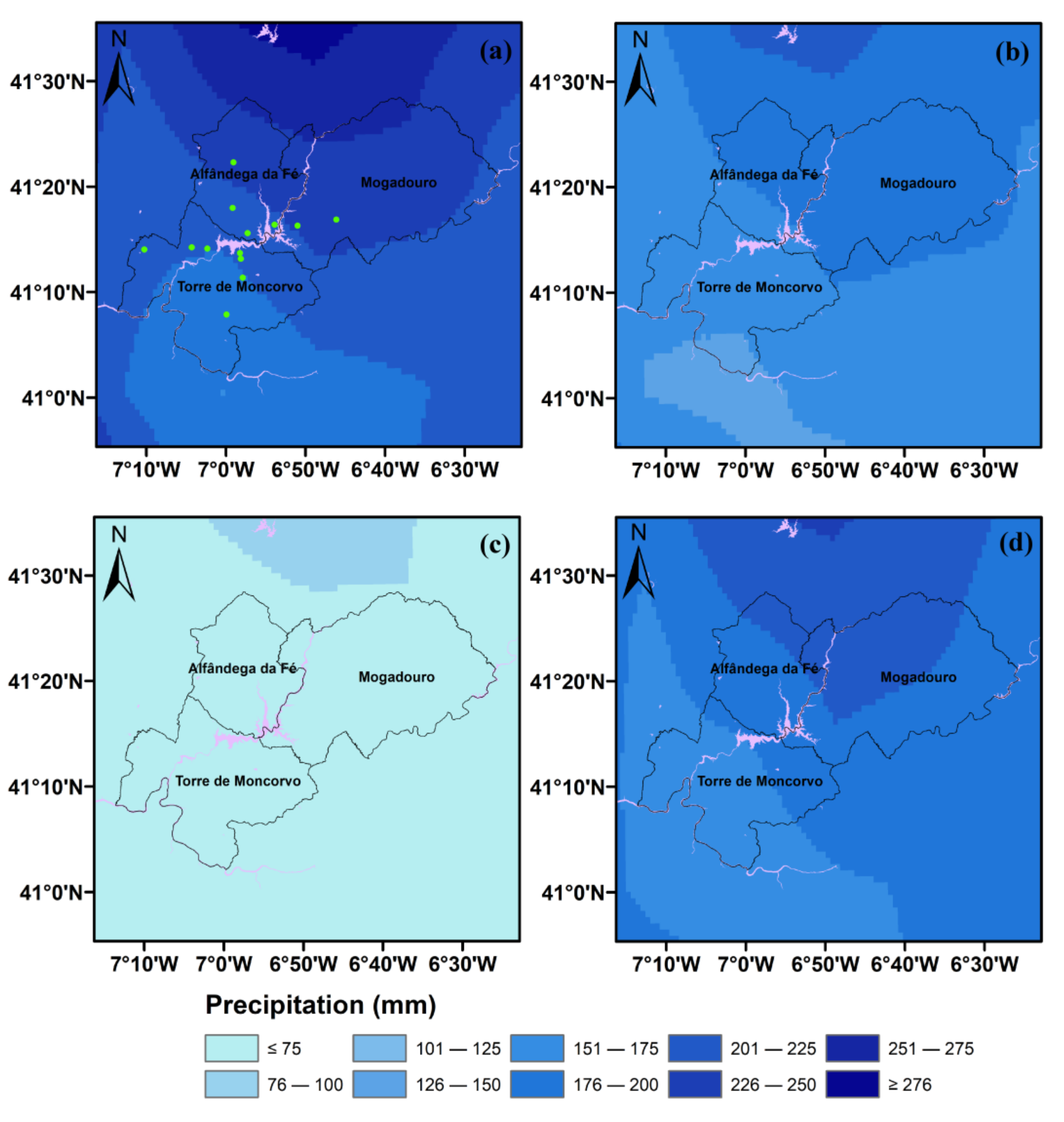
To analyze the spatial distribution of mean air temperature and precipitation, for each season of the year, the respective mean seasonal temperature (Figure 2) and precipitation (Figure 3) fields were plotted, based on an existing gridded dataset of ~1 km spatial resolution for Portugal for the period 2011–2020, PT.HRES [9,41]. The mean air temperature varied between 3.5 °C (lowest observed in winter) and 24 °C (highest in summer). The higher temperature values are observed in the westernmost part of the study area, next to the reservoir and streamlines, throughout the year. Regarding precipitation, seasonal values varied between 75 mm (in summer) and 276 mm (in winter), with a decreasing gradient from north to south.
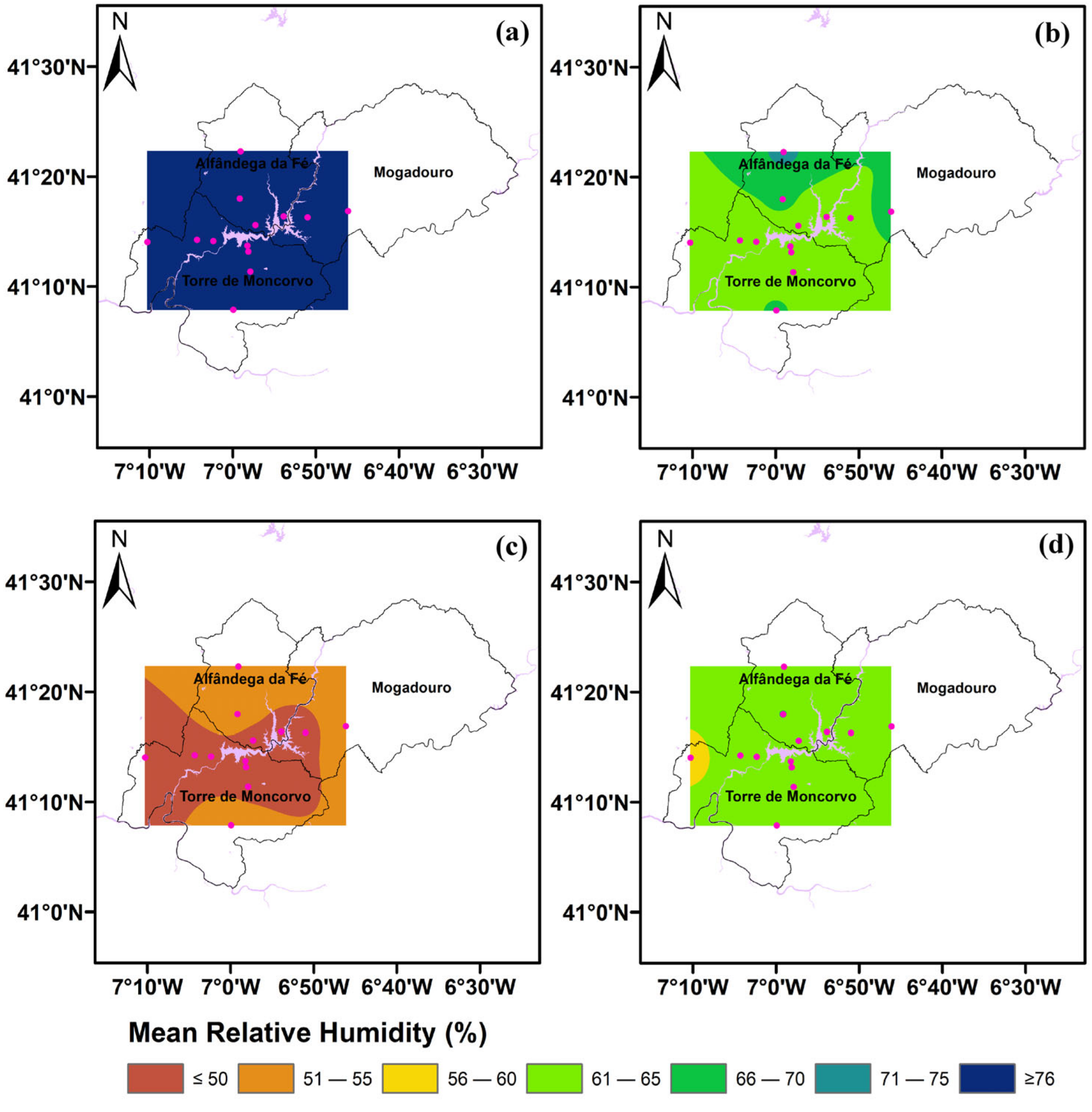
Regarding the seasonal mean relative humidity (Figure 4), which was based on data collected from the AWS and TH for the entire period (2011–2020) because it is not available in the PT.HRES database, its values ranged from approximately 50% (in summer) to 76% (in the winter). The PT.HRES is an observation-based gridded high spatial resolution database (~1 km) for mean, minimum, and maximum temperature, in addition to precipitation, for mainland Portugal and for the period of 1950–2020 [9].
A correspondence analysis between the Vila Real and Bragança AWS shows a satisfactory correlation between the two control stations, with a coefficient of determination above 0.94 for the mean and maximum temperature, whereas the minimum temperature shows a 0.85 value for the period 2011–2020 (Figure S1). A coefficient of determination above 0.86 was obtained for the mean, maximum, and minimum temperature over the longer period of 1941–2020 (Figure S2). The altitude difference between both stations is 278 m, with the AWS Bragança being at an altitude of 690 m. Notably, high altitude locations are generally more predisposed to local factors and, hence, temperature extremes may be less predictable [48].
Figure 2. Spatial distribution of mean temperature in the target region of the Baixo Sabor Hydroelectric Plant (BSHP) for the period 2011–2020: (a) winter; (b) spring; (c) summer; and (d) autumn.
Atmosphere 12 01400 g002
Figure 3. Spatial distribution of total precipitation in the target region of the Baixo Sabor Hydroelectric Plant (BSHP) for the period 2011–2020: (a) winter; (b) spring; (c) summer; and (d) autumn.
Atmosphere 12 01400 g003
Figure 4. Spatial distribution of mean relative humidity in the target region of the Baixo Sabor Hydroelectric Plant (BSHP) for the period 2011–2020: (a) winter; (b) spring; (c) summer; and (d) autumn.
Atmosphere 12 01400 g004

3.2. Daily Trends

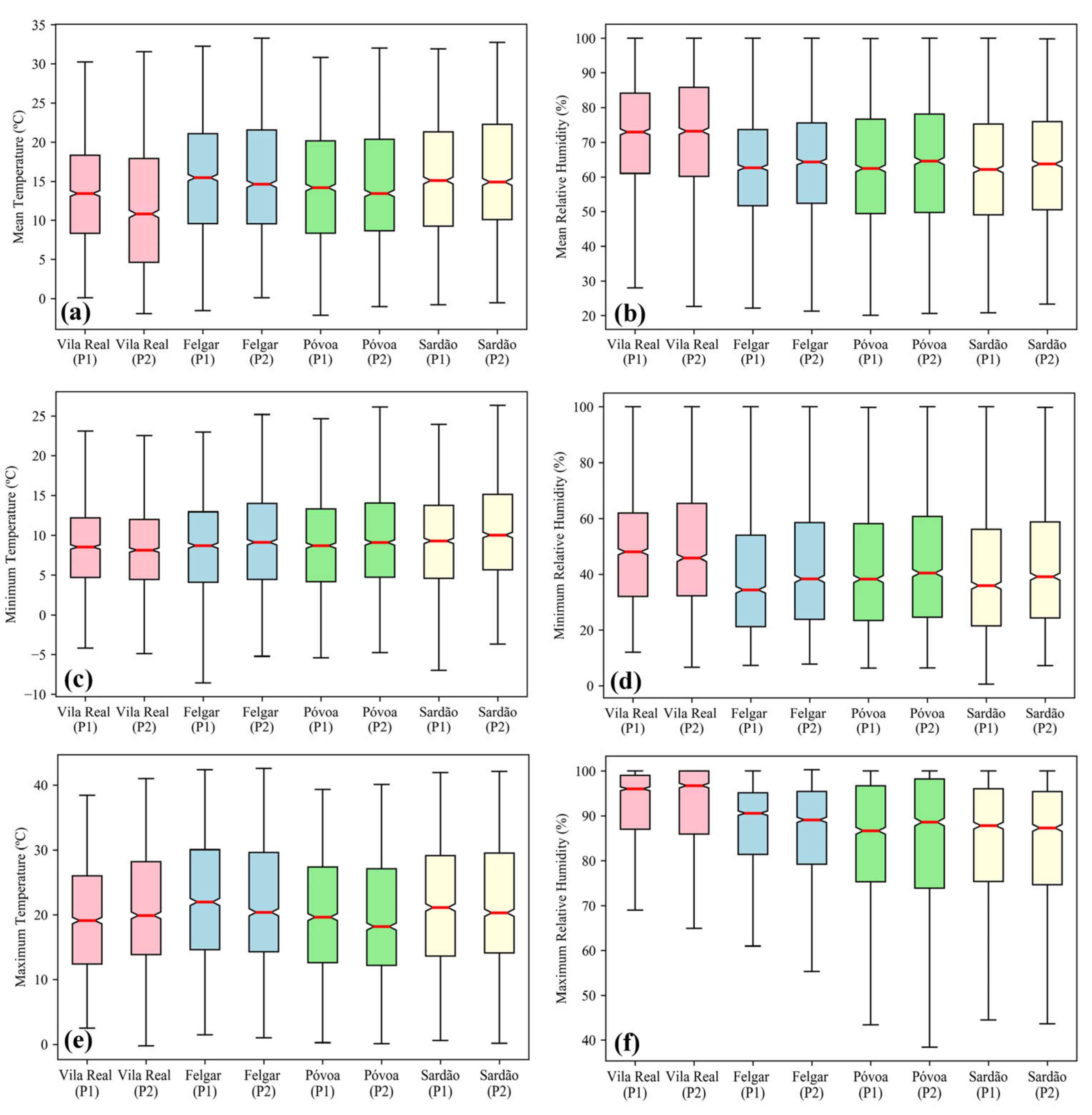
The boxplots of the daily values for both temperature and relative humidity (Figure 5) show the variation between the two established periods, the beginning of the monitoring study (2010–2015) and after the completion of the reservoir filling (2015–2020), for both the control station and the AWS network. Daily values of maximum temperature for the control station (Vila Real) show an increase in the median temperature values from one period to another, in addition to an increase in the extreme temperature values, thus denoting the current climate change trend. By comparison, the AWS stations reveal a decrease in the median values and weak changes in the extreme values. For the minimum temperature, the opposite is observed, with higher median temperature values for the AWS for the latter period, and an overall warming shift is observed. Small changes are observed for the daily values of minimum relative humidity, with a decrease in the median value for the control station and an increase in the AWS network stations. The Mann–Whitney U test [49], also known as the Wilcoxon rank sum test, was performed between each group of timeseries (per station per period). All tests indicated a rejection of the null hypothesis (h = 1) at the 5% significance level, i.e., confirming that both timeseries are continuous distributions with different medians.
Figure 5. Boxplots of daily temperature (left panel) and daily relative humidity (right panel) for the AWS network stations and Vila Real control station for the period 2011–2015 (P1) and 2016–2020 (P2): (a,b) mean values; (c,d) minimum values; and (e,f) maximum values.
Atmosphere 12 01400 g005
Regarding precipitation, there is not enough data relating to the frequency of heavy precipitation to evaluate the patterns before and after the filling of the reservoir. Further, precipitation in Portugal is mainly driven by large-scale atmospheric variability or convective extreme precipitation events generated by mesoscale systems (e.g., thunderstorms) [50]. Hence, it is very unlikely that the water reservoirs influenced the precipitation regime in the study region.

3.3. Anomaly Trends

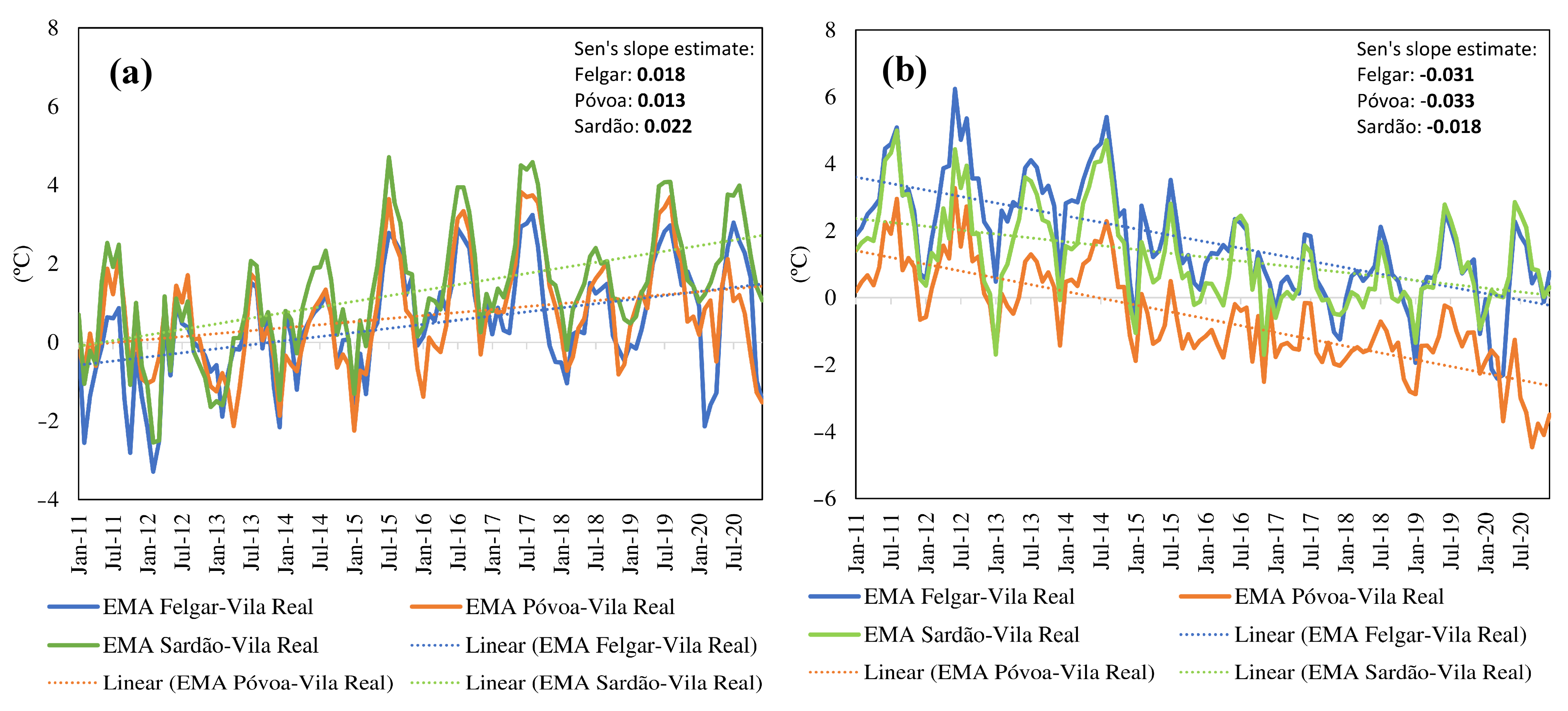
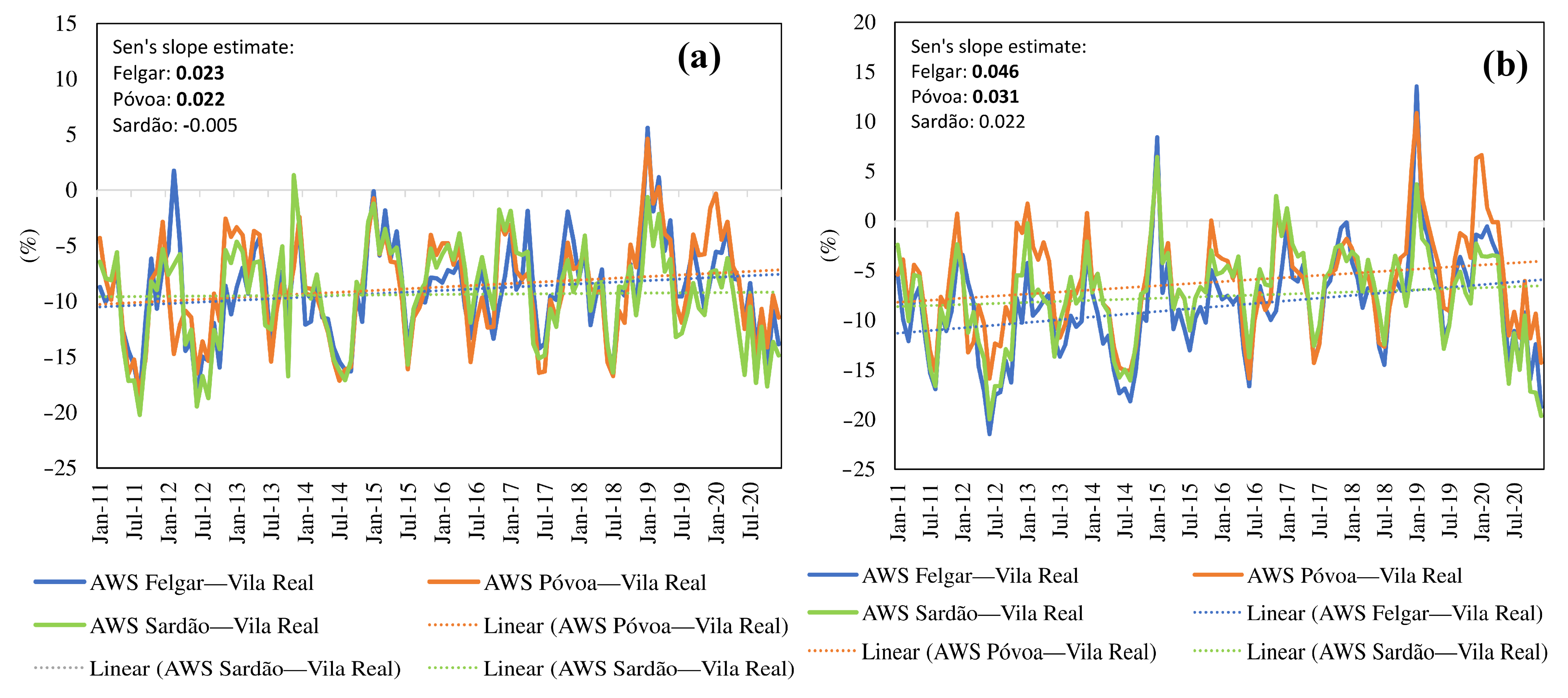
The analysis of anomalies was carried out at a monthly scale to allow for a more robust statistical analysis (i.e., a longer time series). The seasonal cycle was partially removed by calculating the anomalies (differences between each AWS station and the control station—Vila Real), although some seasonality persisted, given the greater annual thermal amplitudes in Baixo Sabor than in Vila Real. The trends of monthly minimum (Figure 6a) and maximum (Figure 6b) temperature anomalies in the AWS relative to the Vila Real control station are represented. Trends in monthly maximum temperature anomalies are negative and statistically significant according to Sen’s slope estimate, whereas monthly minimum temperature anomalies are positive and also statistically significant. The effect of the BSHP reservoir on the local temperature is also noticeable. As stated previously, the reservoir filling was accomplished in 2015, when the monthly maximum/minimum temperature anomalies started to decrease/increase significantly, respectively, reflecting a decrease in local temperature amplitudes. The monthly maximum temperature anomalies decreased by approximately 2 °C (average) between 2016 and 2020 when compared to the years before the filling of the reservoir, whereas the monthly minimum temperature anomalies increased by nearly 1.4 °C (average).
Concerning the trends of relative humidity, there was an increase in the monthly mean and minimum relative humidity of approximately 2% and 3% over the whole period, respectively (Figure 7). This was statistically significant for Felgar and Sardão stations, with no noticeable change in the monthly maximum relative humidity.
To further confirm and identify the temporal trends in the time series of temperature and relative humidity variables, a Spearmen rho test analysis was performed (Table 2).
The Spearman rho test indicates a negative trend in the maximum temperature and positive trend in minimum temperature for a 95% confidence interval. Regarding the relative humidity, a positive trend was detected for Felgar and Póvoa stations.

4. Conclusions

The Baixo Sabor Hydroelectric Plant (BSHP) is of fundamental importance for the national energy sector. This paper has, however, highlighted its impacts on the climate in its close vicinity. In this study, temperature and humidity parameters around the BSHP dam were compared for the periods before (2011–2015) and after (2016–2020), i.e., the dam-building and filling up of the reservoirs, respectively. The results from the trend analysis and Sen’s slope estimate statistical test hint at an influence on the climatic characteristics of the target region surrounding the BSHP. The relative humidity was found to increase, whereas the temperature amplitude decreased from the former to the later period. According to the analysis of daily temperature at the selected stations, average values remained constant, even though the thermal amplitude decreased. Overall, significant shifts were detected for temperature and relative humidity in the post-dam period, which can be interpreted as a direct effect of the dam construction. The analyses shown here only report 5 years of data for the exploration phase. Nonetheless, if relative humidity continues to increase in the future, significant changes can be reflected in local temperatures, which may reveal more clearly the change in the microclimate of the region.
Therefore, the present study provides further evidence of the impacts that large dams may have on their surrounding local climatic conditions in the future. In this particular case, due to the prevailing dry and warm conditions of the implementation region, which is characterized by sub-arid conditions that are projected to be exacerbated under climate change [44,45], these changes directly contribute to the mitigation of the observed large-scale warming and drying trends, but also, indirectly, to the mitigation of the greenhouse gas emissions through the generation of renewable energy. The mitigation of the regional climate change signal may positively affect some major local agricultural activities that are heavily dependent on irrigation, such as viticulture and oliviculture [43]. The creation of water reservoirs is also of major importance for such a dry region, which has very limited water availability, even for human consumption, that is significantly threatened by ongoing climate change. The present study thus contributes to a more scientifically-grounded discussion on the actual role played by hydroelectric power plants in dry regions globally, because most of the results can be extrapolated to other regions with similar climatic features and surrounding environments.

Supplementary Materials

The following are available online at https://www.mdpi.com/article/10.3390/atmos12111400/s1, Table S1: AWS and TH sensor brand specification. Table S2: Automatic Weather Station (AWS), Thermo-hydrometric station (THs) and control station characteristics. Figure S1: Temperature correlation between Vila Real and Bragança; (a) mean temperature, (b) minimum temperature, and (c) maximum temperature for the period 2011–2020. Figure S2: Temperature correlation between Vila Real and Bragança; (a) mean temperature, (b) minimum temperature, and (c) maximum temperature for the period 1941–2020.

Author Contributions

For this research, the author’s contributions were: conceptualization, A.F. and J.A.S.; methodology, A.F. and J.A.S.; investigation, A.F. and J.A.S.; data curation, A.F.; writing—original draft preparation, A.F.; writing—review and editing, J.A.S. All authors have read and agreed to the published version of the manuscript.

Funding

This work is supported by National Funds by FCT—Portuguese Foundation for Science and Technology, under the project UIDB/04033/2020.

Institutional Review Board Statement

Not applicable.

Informed Consent Statement

Not applicable.

Data Availability Statement

Not applicable.

Acknowledgments

Data originated during the monitoring was carried out under the PIMA (Integrated Environmental Monitoring Plan) for the Baixo Sabor Hydroelectric Plant (PIMA-AHBS), EDP—Gestão da Produção de Energia, SA.

Conflicts of Interest

The authors declare no conflict of interest.

References

  1. Elagib, N.A.; Basheer, M. Would Africa’s Largest Hydropower Dam Have Profound Environmental Impacts? Environ. Sci. Pollut. Res. 2021, 28, 8936–8944. [Google Scholar] [CrossRef]
  2. Seo, S.N. Energy Revolutions: A Story of the Three Gorges Dam in China. In Climate Change and Economics; Springer: Berlin/Heidelberg, Germany, 2021; pp. 113–129. [Google Scholar]
  3. Bayazıt, Y. The Effect of Hydroelectric Power Plants on the Carbon Emission: An Example of Gokcekaya Dam, Turkey. Renew. Energy 2021, 170, 181–187. [Google Scholar] [CrossRef]
  4. O’Connor, F.M.; Abraham, N.L.; Dalvi, M.; Folberth, G.A.; Griffiths, P.T.; Hardacre, C.; Johnson, B.T.; Kahana, R.; Keeble, J.; Kim, B. Assessment of Pre-Industrial to Present-Day Anthropogenic Climate Forcing in UKESM1. Atmos. Chem. Phys. 2021, 21, 1211–1243. [Google Scholar] [CrossRef]
  5. Skeie, R.B.; Berntsen, T.K.; Myhre, G.; Tanaka, K.; Kvalevåg, M.M.; Hoyle, C.R. Anthropogenic Radiative Forcing Time Series from Pre-Industrial Times until 2010. Atmos. Chem. Phys. 2011, 11, 11827–11857. [Google Scholar] [CrossRef] [Green Version]
  6. Kum, G. The Influence of Dams on Surrounding Climate: The Case of Keban Dam. Gaziantep Univ. J. Soc. Sci. 2016, 15, 193–204. [Google Scholar] [CrossRef] [Green Version]
  7. Gyau-Boakye, P. Environmental Impacts of the Akosombo Dam and Effects of Climate Change on the Lake Levels. Environ. Dev. Sustain. 2001, 3, 17–29. [Google Scholar] [CrossRef]
  8. Martins, J.; Fraga, H.; Fonseca, A.; Santos, J.A. Climate Projections for Precipitation and Temperature Indicators in the Douro Wine Region: The Importance of Bias Correction. Agronomy 2021, 11, 990. [Google Scholar] [CrossRef]
  9. Fonseca, A.R.; Santos, J.A. High-Resolution Temperature Datasets in Portugal from a Geostatistical Approach: Variability and Extremes. J. Appl. Meteorol. Climatol. 2018, 57, 627–644. [Google Scholar] [CrossRef]
  10. Santos, M.; Fonseca, A.; Fraga, H.; Jones, G.V.; Santos, J.A. Bioclimatic Conditions of the Portuguese Wine Denominations of Origin under Changing Climates. Int. J. Climatol. 2020, 40, 927–941. [Google Scholar] [CrossRef]
  11. Fonseca, A.R.; Santos, M.; Santos, J.A. Hydrological and Flood Hazard Assessment Using a Coupled Modelling Approach for a Mountainous Catchment in Portugal. Stoch. Environ. Res. Risk Assess. 2018, 32, 2165–2177. [Google Scholar] [CrossRef]
  12. Fonseca, A.R.; Santos, J.A. A New Very High-Resolution Climatological Dataset in Portugal: Application to Hydrological Modeling in a Mountainous Watershed. Phys. Chem. Earth 2019, 109, 2–8. [Google Scholar] [CrossRef]
  13. Fonseca, A.R.; Santos, J.A. Predicting Hydrologic Flows under Climate Change: The Tâmega Basin as an Analog for the Mediterranean Region. Sci. Total Environ. 2019, 668, 1013–1024. [Google Scholar] [CrossRef] [PubMed]
  14. Santos, M.; Fonseca, A.; Fragoso, M.; Santos, J.A. Recent and Future Changes of Precipitation Extremes in Mainland Portugal. Theor. Appl. Climatol. 2019, 137, 1305–1319. [Google Scholar] [CrossRef]
  15. Fonseca, A.R.; ASantos, J.; Varandas, S.G.; Monteiro, S.M.; Martinho, J.L.; Cortes, R.; Cabecinha, E. Current and Future Ecological Status Assessment: A New Holistic Approach for Watershed Management. Water 2020, 12, 2839. [Google Scholar] [CrossRef]
  16. Vieira, J.; Fonseca, A.; Vilar, V.J.P.; Boaventura, R.A.R.; Botelho, C.M.S. Water Quality in Lis River, Portugal. Environ. Monit. Assess. 2012, 184, 7125–7140. [Google Scholar] [CrossRef]
  17. Vieira, J.; Fonseca, A.; Vilar, V.J.P.; Boaventura, R.A.R.; Botelho, C.M.S. Water Quality Modelling of Lis River, Portugal. Environ. Sci. Pollut. Res. 2013, 20, 508–524. [Google Scholar] [CrossRef]
  18. Fonseca, A.; Botelho, C.; Boaventura, R.A.R.; Vilar, V.J.P. Global Warming Effects on Faecal Coliform Bacterium Watershed Impairments in Portugal. River Res. Appl. 2015, 31, 1344–1353. [Google Scholar] [CrossRef]
  19. Fonseca, A.; Boaventura, R.A.R.; Vilar, V.J.P. Integrating Water Quality Responses to Best Management Practices in Portugal. Environ. Sci. Pollut. Res. 2018, 25, 1587–1596. [Google Scholar] [CrossRef]
  20. Tata, L.R.R. Biodiversity Impact Assessment of Two Large Dam Projects in India under Long Term Multi-Scenarios Simulation. Impact Assess. Proj. Apprais. 2021, 39, 335–347. [Google Scholar] [CrossRef]
  21. Kundu, S.; Pal, S.; Talukdar, S.; Mandal, I. Impact of Wetland Fragmentation Due to Damming on the Linkages between Water Richness and Ecosystem Services. Environ. Sci. Pollut. Res. 2021, 28, 50266–50285. [Google Scholar] [CrossRef]
  22. Wilk-Woźniak, E.; Krztoń, W.; Górnik, M. Synergistic Impact of Socio-Economic and Climatic Changes on the Ecosystem of a Deep Dam Reservoir: Case Study of the Dobczyce Dam Reservoir Based on a 30-Year Monitoring Study. Sci. Total Environ. 2021, 756, 144055. [Google Scholar] [CrossRef]
  23. Niyogi, D.; Kishtawal, C.; Tripathi, S.; Govindaraju, R.S. Observational Evidence That Agricultural Intensification and Land Use Change May Be Reducing the Indian Summer Monsoon Rainfall. Water Resour. Res. 2010, 46. [Google Scholar] [CrossRef] [Green Version]
  24. Takata, K.; Saito, K.; Yasunari, T. Changes in the Asian Monsoon Climate during 1700–1850 Induced by Preindustrial Cultivation. Proc. Natl. Acad. Sci. USA 2009, 106, 9586–9589. [Google Scholar] [CrossRef] [Green Version]
  25. Degu, A.M.; Hossain, F.; Niyogi, D.; Pielke, R., Sr.; Shepherd, J.M.; Voisin, N.; Chronis, T. The Influence of Large Dams on Surrounding Climate and Precipitation Patterns. Geophys. Res. Lett. 2011, 38. [Google Scholar] [CrossRef]
  26. Hamlet, A.F.; Lettenmaier, D.P. Effects of Climate Change on Hydrology and Water Resources in the Columbia River Basin 1. J. Am. Water Resour. Assoc. 1999, 35, 1597–1623. [Google Scholar] [CrossRef]
  27. Yang, W.; Yang, H.; Yang, D.; Hou, A. Causal Effects of Dams and Land Cover Changes on Flood Changes in Mainland China. Hydrol. Earth Syst. Sci. 2021, 25, 2705–2720. [Google Scholar] [CrossRef]
  28. Christensen, N.S.; Wood, A.W.; Voisin, N.; Lettenmaier, D.P.; Palmer, R.N. The Effects of Climate Change on the Hydrology and Water Resources of the Colorado River Basin. Clim. Chang. 2004, 62, 337–363. [Google Scholar] [CrossRef]
  29. Bussi, G.; Darby, S.E.; Whitehead, P.G.; Jin, L.; Dadson, S.J.; Voepel, H.E.; Vasilopoulos, G.; Hackney, C.R.; Hutton, C.; Berchoux, T. Impact of Dams and Climate Change on Suspended Sediment Flux to the Mekong Delta. Sci. Total Environ. 2021, 755, 142468. [Google Scholar] [CrossRef] [PubMed]
  30. Lin, X.; Huang, G.; Piwowar, J.M.; Zhou, X.; Zhai, Y. Risk of Hydrological Failure under the Compound Effects of Instant Flow and Precipitation Peaks under Climate Change: A Case Study of Mountain Island Dam, North Carolina. J. Clean. Prod. 2021, 284, 125305. [Google Scholar] [CrossRef]
  31. Fluixá-Sanmartín, J.; Escuder-Bueno, I.; Morales-Torres, A.; Castillo-Rodríguez, J.T. Accounting for Climate Change Uncertainty in Long-Term Dam Risk Management. J. Water Resour. Plan. Manag. 2021, 147, 04021012. [Google Scholar] [CrossRef]
  32. Qi, P.; Xu, Y.J.; Wang, G. Quantifying the Individual Contributions of Climate Change, Dam Construction, and Land Use/Land Cover Change to Hydrological Drought in a Marshy River. Sustainability 2020, 12, 3777. [Google Scholar] [CrossRef]
  33. Zhang, Z.; Liu, J.; Huang, J. Hydrologic Impacts of Cascade Dams in a Small Headwater Watershed under Climate Variability. J. Hydrol. 2020, 590, 125426. [Google Scholar] [CrossRef]
  34. Miller, N.L.; Jin, J.; Tsang, C.-F. Local Climate Sensitivity of the Three Gorges Dam. Geophys. Res. Lett. 2005, 32. [Google Scholar] [CrossRef] [Green Version]
  35. Correia, M.F.; da Silva Dias, M.A.F.; da Silva Aragão, M.R. Soil Occupation and Atmospheric Variations over Sobradinho Lake Area. Part Two: A Regional Modeling Study. Meteorol. Atmos. Phys. 2006, 94, 115–128. [Google Scholar] [CrossRef]
  36. Yilmaz, L. Meteorological Climate Change Effect of the Ataturk Dam in Turkey at Eastern Anatolia. Mater. Geoenviron. 2006, 53, 467. [Google Scholar]
  37. Kellogg, C.H.; Zhou, X. Impact of the Construction of a Large Dam on Riparian Vegetation Cover at Different Elevation Zones as Observed from Remotely Sensed Data. Int. J. Appl. Earth Obs. Geoinf. 2014, 32, 19–34. [Google Scholar] [CrossRef]
  38. Aguiar, F.C.; Fernandes, M.R.; Martins, M.J.; Ferreira, M.T. Effects of a Large Irrigation Reservoir on Aquatic and Riparian Plants: A History of Survival and Loss. Water 2019, 11, 2379. [Google Scholar] [CrossRef] [Green Version]
  39. Santos, R.M.B.; Sanches Fernandes, L.F.; Cortes, R.M.V.; Varandas, S.G.P.; Jesus, J.J.B.; Pacheco, F.A.L. Integrative Assessment of River Damming Impacts on Aquatic Fauna in a Portuguese Reservoir. Sci. Total Environ. 2017, 601–602, 1108–1118. [Google Scholar] [CrossRef]
  40. Santos, M.J.; Pedroso, N.M.; Ferreira, J.P.; Matos, H.M.; Sales-Luís, T.; Pereira, Í.; Baltazar, C.; Grilo, C.; Cândido, A.T.; Sousa, I.; et al. Assessing Dam Implementation Impact on Threatened Carnivores: The Case of Alqueva in SE Portugal. Environ. Monit. Assess. 2008, 142, 47–64. [Google Scholar] [CrossRef] [PubMed]
  41. Andrade, C.; Contente, J.; Santos, J.A. Climate Change Projections of Aridity Conditions in the Iberian Peninsula. Water 2021, 13, 2035. [Google Scholar] [CrossRef]
  42. Andrade, C.; Contente, J.; Santos, J.A. Climate Change Projections of Dry and Wet Events in Iberia Based on the WASP-Index. Climate 2021, 9, 94. [Google Scholar] [CrossRef]
  43. Andrade, C.; Fonseca, A.; Santos, J.A. Are Land Use Options in Viticulture and Oliviculture in Agreement with Bioclimatic Shifts in Portugal? Land 2021, 10, 869. [Google Scholar] [CrossRef]
  44. World Meteorological Organization. Guide to Meteorological Instruments and Methods of Observation; Secretariat of the World Meteorological Organization: Geneva, Switzerland, 1983. [Google Scholar]
  45. Klein Tank, A.M.G.; Wijngaard, J.B.; Können, G.P.; Böhm, R.; Demarée, G.; Gocheva, A.; Mileta, M.; Pashiardis, S.; Hejkrlik, L.; Kern-Hansen, C. Daily Dataset of 20th-century Surface Air Temperature and Precipitation Series for the European Climate Assessment. Int. J. Climatol. J. R. Meteorol. Soc. 2002, 22, 1441–1453. [Google Scholar] [CrossRef]
  46. Sen, P.K. Estimates of the Regression Coefficient Based on Kendall’s Tau. J. Am. Stat. Assoc. 1968, 63, 1379–1389. [Google Scholar] [CrossRef]
  47. Daniels, H.E. Rank Correlation and Population Models. J. R. Stat. Society Ser. B Methodol. 1950, 12, 171–191. [Google Scholar] [CrossRef]
  48. Revadekar, J.V.; Hameed, S.; Collins, D.; Manton, M.; Sheikh, M.; Borgaonkar, H.P.; Kothawale, D.R.; Adnan, M.; Ahmed, A.U.; Ashraf, J.; et al. Impact of Altitude and Latitude on Changes in Temperature Extremes over South Asia during 1971–2000. Int. J. Climatol. 2013, 33, 199–209. [Google Scholar] [CrossRef]
  49. Gibbons, J.D.; Chakraborti, S. Nonparametric Statistical Inference: Revised and Expanded; CRC Press: Boca Raton, FL, USA, 2014; ISBN 0203911563. [Google Scholar]
  50. Santos, J.A.; Corte-Real, J.; Leite, S.M. Weather Regimes and Their Connection to the Winter Rainfall in Portugal. Int. J. Climatol. J. R. Meteorol. Soc. 2005, 25, 33–50. [Google Scholar] [CrossRef]
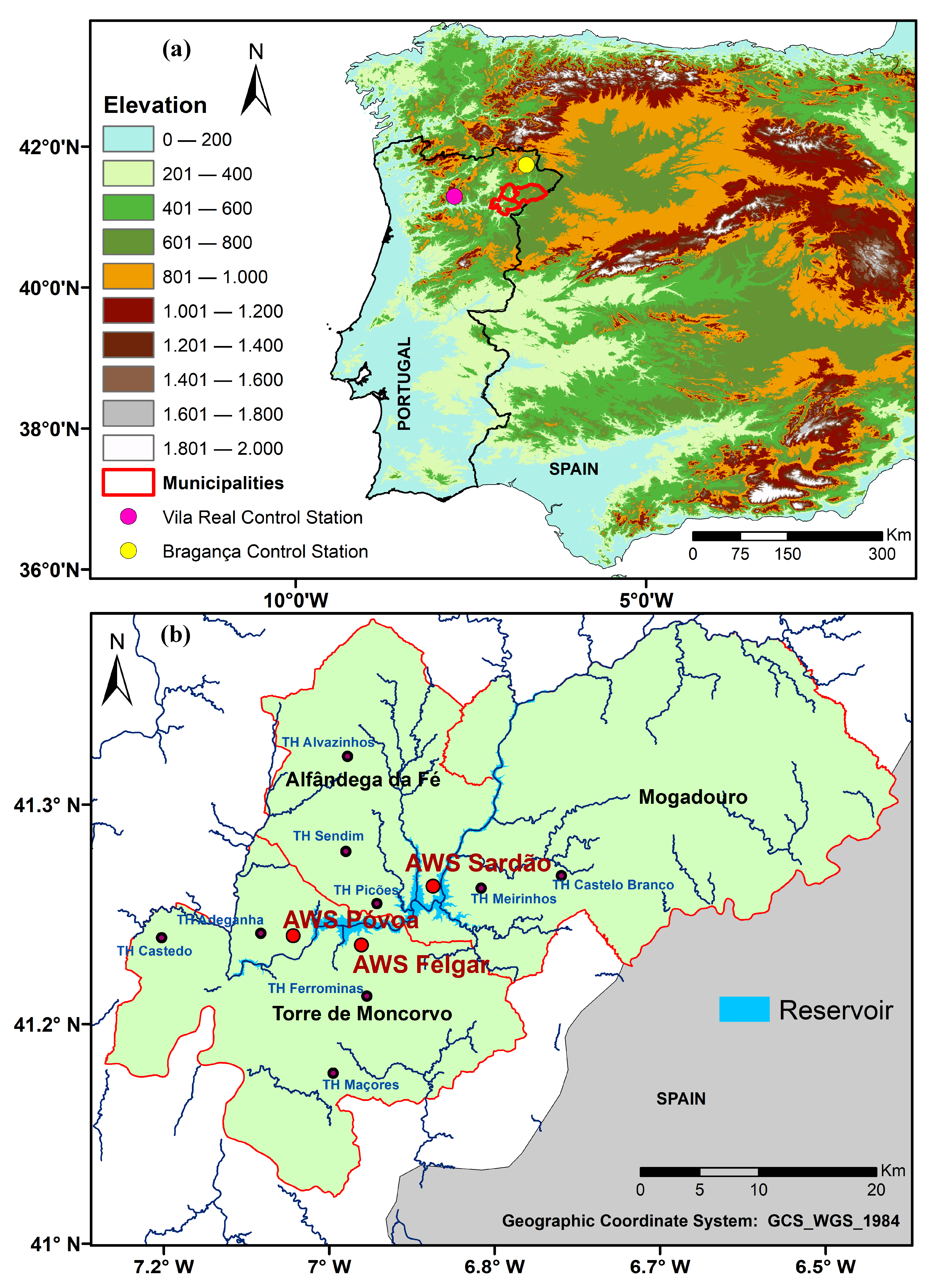
Figure 1. (a) Geographical location of the municipalities of the reservoir area (target area) from the Baixo Sabor Hydroelectric Plant (BSHP), and the location of the Vila Real Control Station; (b) location of the three automatic weather stations (AWS), Póvoa, Felgar, and Sardão, and of the six thermohygrometric automatic stations (TH) within the target area.
Atmosphere 12 01400 g001
Figure 6. Monthly temperature anomalies trend between the AWS network stations and the Vila Real control station for the period 2011–2020: (a) minimum temperature and (b) maximum temperature.
Atmosphere 12 01400 g006
Figure 7. Monthly relative humidity anomalies trend between the AWS network stations and the Vila Real control station for the period 2011–2020: (a) mean relative humidity and, (b) minimum relative humidity.
Atmosphere 12 01400 g007
Table 2. Spearman rho test results and p-values (X/Y) for the climate variables of the three AWS.
AWSTGTXTNHRGHRXHRN
Felgar0/0.10−1/01/01/0.040/0.571/0
Póvoa−1/0−1/01/00/0.060/0.561/0.02
Sardão0/0.36−1/01/00/0.880/0.080/0.07
* Key: TG: mean temperature; TX: maximum temperature; TN: minimum temperature; HRG: mean relative humidity; HRX: maximum relative humidity; HRN: minimum relative humidity; (X/Y): X (1: positive trend; −1: negative trend; 0: failure to reject the null hypotheses) and Y is the p-value.
Publisher’s Note: MDPI stays neutral with regard to jurisdictional claims in published maps and institutional affiliations.