Article

Spatial-Temporal Changes of Methane Content in the Atmosphere for Selected Countries and Regions with High Methane Emission from Rice Cultivation

by
Katarzyna Kozicka
,
Dariusz Gozdowski
and
Elżbieta Wójcik-Gront
*
Department of Biometry, Institute of Agriculture, Warsaw University of Life Sciences—SGGW, Nowoursynowska 159, 02-776 Warsaw, Poland
*
Author to whom correspondence should be addressed.
Atmosphere 2021, 12(11), 1382; https://doi.org/10.3390/atmos12111382
Submission received: 29 August 2021 / Revised: 12 October 2021 / Accepted: 18 October 2021 / Published: 22 October 2021
(This article belongs to the Section Biosphere/Hydrosphere/Land–Atmosphere Interactions)

Abstract

:
Irrigated and flooded rice is associated with methane (CH4) emissions. CH4 is one of the most important anthropogenic greenhouse gases (GHG) in the atmosphere. Nowadays, mapping CH4 content at a global scale is possible using satellite sensors. Sample of such a sensor is TROPOspheric Monitoring Instrument (TROPOMI) placed on the Sentinel-5 Precursor (Sentinel-5P) satellite board. In this study, the evaluation of spatial-temporal changes in CH4 content in the atmosphere for selected countries and regions with high CH4 emissions from rice cultivation in 2019–2021 was performed. Visual evaluation of the spatial variability on CH4 content for the total study period indicates higher CH4 content for almost all areas with high rice concentration. This was confirmed by positive correlations between CH4 content in the atmosphere and estimated GHG emissions from croplands analyzed separately for each studied country/region. In addition, seasonal changes in CH4 content in the atmosphere were observed. The lowest CH4 content was observed at the beginning of the year (for the first quarter of the year) and the highest for the third quarter of the year. Moreover, a long-term increase in CH4 was noticed. Regression analysis revealed that the mean increase in CH4 content in most of the studied regions/countries was about 15 ppb per year. CH4 content evaluated with the use of satellite data from Sentinel-5P is a reliable data source and can be used for the analysis of temporal changes at various spatial scales, including regions and countries.

1. Introduction

Rice is one of the most important crops in the world with a cultivation area covering around 150 million hectares, of which around 50% is irrigated and flooded for most of the rice-growing season [1]. In the last 50 years, the global rice harvest area has increased by 40% due to the expansion and intensification of rice cultivation which is one of the staple foods for a rapidly growing population [2]. The rice-growing area is mainly located in Southeast Asia, which accounts for 90% of the world’s rice cultivation [3,4]. In addition to China, India, and Thailand, the largest rice exporters are also the United States, where the cultivation is mainly located in the Arkansas Non-Delta, Mississippi River Delta, Gulf Coast, and Sacramento Valley of California regions [5]. The cultivation of rice is associated with increased methane (CH4) emissions. The practice of flooding rice fields, leading to anaerobic conditions, promotes the formation and release of CH4 [6]. The water blocks oxygen from penetrating the soil, creating ideal conditions for bacteria that emit CH4.
CH4 is the second most important anthropogenic greenhouse gas in the atmosphere, next to carbon dioxide (CO2). Its global warming potential (GWP) over a 100-year time horizon is 25 times greater than that of CO2 [7]. Global CH4 emissions from rice fields are estimated to be more than 8% of total global anthropogenic CH4 emissions [8]. Therefore, rice fields have a significant impact on the total global CH4 emissions. Understanding the spatial distribution of CH4 emissions from this crop and its changes over time is extremely important for understanding CH4 emissions dynamics and for mitigating climate change.
Frequent mapping of CH4 content at the global scale is possible using satellite sensors [9]. One of the most important sensors for such purpose, because of high spatial resolution and short revisit time, is the TROPOMI (TROPOspheric Monitoring Instrument). It is placed on the Sentinel-5 Precursor (Sentinel-5P) satellite board, which was launched in October 2017 [10]. Satellite data from Sentinel-5P can be transformed to the column-averaged dry-air mixing ratio of CH4 in the atmosphere at spatial resolution 7 × 7 (to August 2019) and 7 × 5.5 km (from August 2019) [11]. For evaluation of CH4 content, two spectral ranges are used, i.e., near-infrared (NIR): 675–775 and short-wave infrared (SWIR): 2305–2385 nm [12]. CH4 content based on Sentinel-5P data is available so far only for land surfaces. For water surfaces, it will be available in a later phase. Satellite CH4 content measurements can be treated as reliable data [13,14]. Sentinel-5P-derived CH4 content is in good agreement with ground-based measurements from the Total Carbon Column Observing Network (TCCON), as well as with data derived from GOSAT satellite observations. TCCON and GOSAT satellite observations have been considered a source of reliable data used for the evaluation of methane content in the atmosphere for many years. Sentinel-5P is quite a new source of such data but high agreement with these two data sources allows considering these data as reliable for evaluation CH4 content all over the globe. In most cases, the standard deviation of mean bias between Sentinel-5P derived CH4 and TCCON is not greater than 15 ppb [15]. When comparing the CH4 content obtained from Sentinel 5P vs. GOSAT, the mean difference was 13.6 ppb, the standard deviation was 19.6 ppb, and the Pearson correlation coefficient was 0.95 [16]. The relative difference between Sentinel-5P versus TCCON-derived methane is very small, less than 1% and a very high correlation coefficient confirms a very high agreement between these two sources of data.
The aim of the study was to evaluate the spatial-temporal changes in CH4 content in the atmosphere for selected countries and regions with high CH4 emissions from rice cultivation in 2019–2021. Using Sentinel-5T data, it can be proven that the CH4 content in the atmosphere is characterized by long-lasting growth and seasonal variability.

2. Materials and Methods
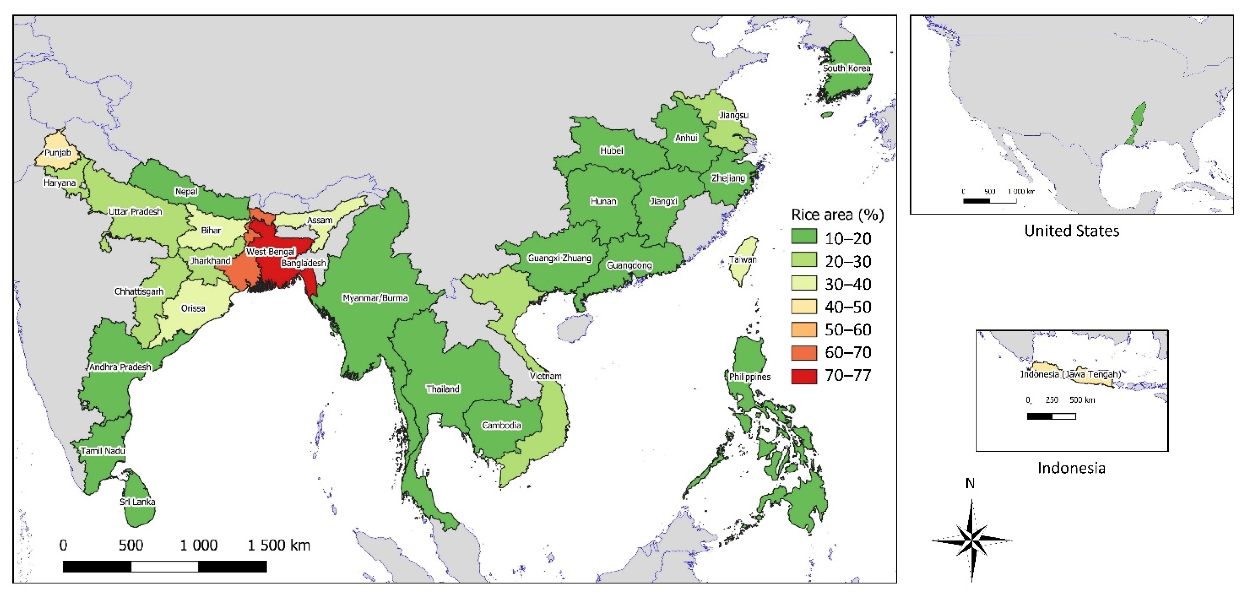
2.1. Study Area

Several countries and regions within countries were selected for the study. In the first step of the analysis, countries were selected based on the high share of CH4 emissions from rice cultivation among agricultural sources using the latest FAOSTAT data for 2019 [17]. The following countries were selected (from the lowest—18% to the highest share—78%): Nepal, Cote d’Ivoire, Solomon Islands, Iraq, Suriname, Dominican Republic, India, Guyana, Lao People’s Democratic Republic, Madagascar, French Guyana, Nigeria, Indonesia, Egypt, Guinea, Myanmar, China, South Korea, Sierra Leone, Gambia, Malaysia, Bangladesh, Japan, North Korea, Cambodia, Sri Lanka, Vietnam, Comoros, Thailand, Philippines. Then, those with at least 10% of the rice cultivation area of the total region/country area were selected. We also added the part of the area of the United States because, although it does not have a high share of rice emissions in the total CH4 emissions. The area taken up by rice crops in the Mississippi region is above 10%. The high spatial resolution (five minutes spatial resolution~10 km × 10 km) data about rice crop share in the total land area come from the study of Ramankutty et al. [18] available at EarthStat/ [19]. They were used for the calculation of rice crop share for selected regions to evaluate the rice share by region/country.
Figure 1 presents a map with the countries and regions included in the study.

2.2. Satellite Data

Data from Sentinel-5P were used for the analyzes. The column-averaged dry-air mixing ratio of CH4 (in ppb—parts per billion) data for the period from 8 February 2019 to 30 June 2021 were used. The Sentinel-5P imagery from the TROPOMI sensor processed as Level 3 (L3) product was used [20]. Datasets were downloaded from the image collection “COPERNICUS/S5P/OFFL/L3_CH4” of Google Earth Engine as georeferenced raster files (in GeoTIFF format file) at spatial resolution 7 × 7 km. Mean values of the column-averaged dry-air mixing ratio of CH4 for 3-month periods were analyzed. The only exception was the first period, which was shorter (from 8 February–31 March 2019).

2.3. Data Analysis

Raster files (GeoTIFF) containing averaged values of the air-methane mixing coefficient were used for further processing. For selected countries or regions, the mean CH4 content for each study period was calculated using the zonal statistics tool in QGIS 3.18 software [21]. The means were used for evaluating the seasonal (within years) and between years changes. Moreover, within countries/regions, spatial-temporal variability was evaluated based on maps for each country or region. The results for the studied countries/regions were compared to the reference areas, i.e., neighboring areas without high concentration of rice cultivation. Three areas were selected as references, i.e., India (without the states with high rice concentration), China (without the provinces with high rice concentration), and the United States (excluding region with high rice concentration).
Relationship between estimated GHG emissions from croplands [19,22] and the mean content of CH4 for the total period of study (from 8 February 2019 to 30 June 2021) were evaluated using Pearson’s correlation coefficient and for selected countries/regions using linear regression analysis.
The worldwide geographical layer of GHG emissions from croplands used for the analyses is at five minutes spatial resolution (~10 km × 10 km) and is based on circa 2000 estimates of GHG emissions which are presented in CO2 equivalent and include CH4, CO2, and N2O emissions. In the case of regions with a high concentration of rice paddy, the emission is mainly determined by CH4 emissions from that crop and their percentage is quite stable from 2000 until now [17]. More details about the methods used for the estimation of GHG emissions are available in the study of Carlson et al. [22] and available at EarthStat [19].
The relationships were evaluated separately for each country/region. These analyses were performed at 42-arc minutes (0.7 degrees of longitude and latitude) resolution, i.e., unit areas of about 75 × 75 km (~5600 km2). For each square, the average CH4 content and the average estimated GHG emissions were calculated in QGIS using zonal statistics. Then, the correlations were calculated separately for each country/region in the Statistica program [23]. The operation was repeated four times with different grid shifts: offset 0, 0.35, 0.175, and 0.525. Then the average, min, and max correlation coefficients were calculated.
Only areas inside the countries/regions were included in the analyses. Units that were located next to the borders of the countries/regions were removed (criterion was at least 3500 km2 of area located inside the country or region). Because of the various sizes of the countries/regions, the number of observations (n) for the analyses varied from 5 to 112. Small regions of rice cultivation were removed from these analyses because the sample size was too small. Due to various sample sizes, the significance of the relationships strongly depends on the number of observations and varies between the countries/regions.

3. Results

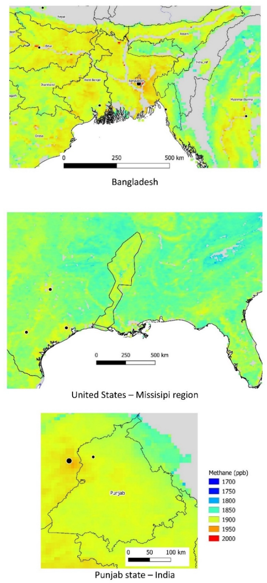
3.1. Methane Content by Country/Region

The mean content of CH4 for the total period of the study (from 8 February 2019 to 30 June 2021) was quite similar for all the studied counties (Table 1).
The lowest content of CH4 (1836 ppb) was observed for Jawa Tengah (an island which is part of Indonesia) while the highest (1904 ppb) for Jiangsu (province of China). These differences between the mean CH4 content for the countries/regions were caused rather by worldwide CH4 spatial variability not local emissions from rice fields. Because of that, further analyses were performed separately for each country/region to avoid the effect of worldwide CH4 variability. Visual evaluation of the spatial variability on CH4 content for the total period of the study based on maps presented in Figure 2 indicates higher CH4 content for areas with high rice concentration. One of the most visible cases is the region of rice cultivation located along the Mississippi River (United States) where CH4 content is much higher (about 50 ppb higher) in comparison to neighboring areas. However, such high CH4 content in areas of rice concentration does not always occur.

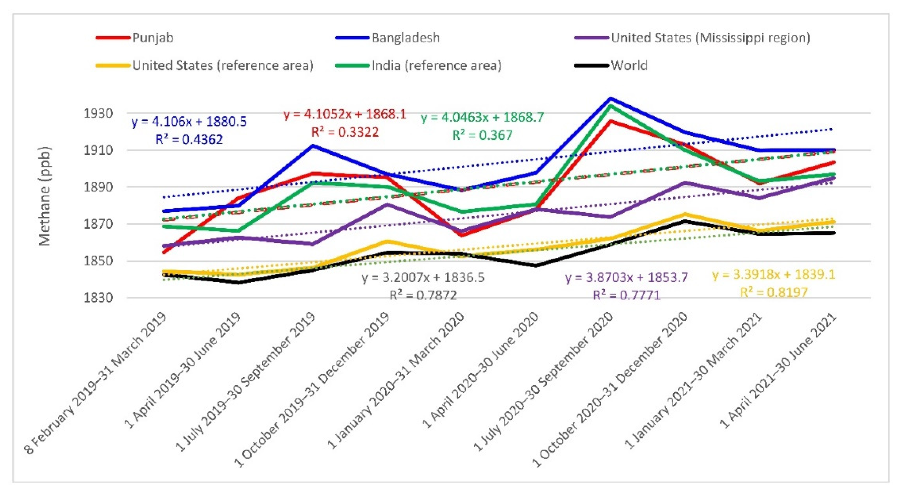
3.2. Temporal Changes in CH4 Content

During the period of the study, seasonal changes, as well as a long-term trend, was observed for the content of CH4 in most of the countries (Table 2). All provinces of China were characterized by a very similar pattern of changes in time. Seasonal changes of CH4 were characterized by the lowest content at the beginning of the year (for the first quarter of the year) and the highest for the third quarter of the year. Moreover, a long-term increase in CH4 was observed. On average, in the period of the study, an increase in CH4 content by 15 ppb per year was observed for the studied provinces of China. Similar seasonal and long-term changes were observed for other regions and countries in Southeast Asia but in some cases, the changes were quite different. For example, in the states Tamil Nadu and Andhra Pradesh (Southeast India), the lowest seasonal CH4 content was observed for the third quarter of the year. Another example of the exception is Jawa Tengah island (Indonesia), where seasonal changes for CH4 content were very small but long-term changes were very similar to those observed for China. In the Mississippi region (USA), the highest seasonal CH4 content was observed at the end of the year (the fourth quarter of the year), while the lowest was at the beginning of the year. Long-term changes for CH4 were similar for most of the regions of Southeast Asia (increase of about 16 ppb per year). Regression equations presented in Figure 3, which presents averaged CH4 content for 3-month periods, confirm that the mean increase in CH4 content in regions/countries of Southeast Asia is about 16 ppb per year (about 4 ppb per each 3-month period), while in the Mississippi region (United States) the mean increase was about 15.5 ppb per year (3.87 ppb per 3-month period). A similar long-term increase was observed for both parts of India, i.e., where high concentrations of rice production occur, and for other areas of India (mean increase in CH4 content by about 16 ppb per year). In the case of the United States reference area, which is most of the area of the US excluding the main regions of rice cultivation, the mean yearly increase in CH4 content was smaller in comparison to regions with high rice concentration (respectively 13.56 ppb vs. 15.48 ppb of CH4). The increase for total world area (limited to latitudes between 60° S and 60° N) is 12.8 ppb per year (3.20 ppb per 3-month period) and is lower in comparison to areas with rice cultivation. Similar results but for 1-month periods are presented in Figure S1 and allow evaluating temporal changes of CH4 content at higher temporal resolution. It allows observing the short time increase in late summer and beginning of autumn in CH4 content in the regions/countries in south-eastern Asia. The most visible increase can be noticed in Bangladesh in October when maximal CH4 content was observed. The temporal changes observed for 1-month periods are much lower for reference areas, i.e., for total of the United States and total world, which suggest that are strongly dependent on the rice growing period. Regression equations based on 1-month periods presented in Figure S1 suggest a similar long-term trend of CH4 but slightly different in comparison to the regression equations based on 3-month periods. For example, the mean yearly increase in CH4 for total world area (limited to latitudes between 60° S and 60° N) based on regression equation for 1-month periods was equal to 14.1 ppb while based on 3-month periods was slightly lower and equal to 12.9 ppb. Usually, regression equations for studied regions/countries based on 1-month periods prove a slightly higher increase in CH4 in comparison to an increase in CH4 based on respective regression equations for 3-month periods. This is probably caused by higher peaks (yearly maximal content of CH4) for 1-month periods in comparison to 3-month periods.

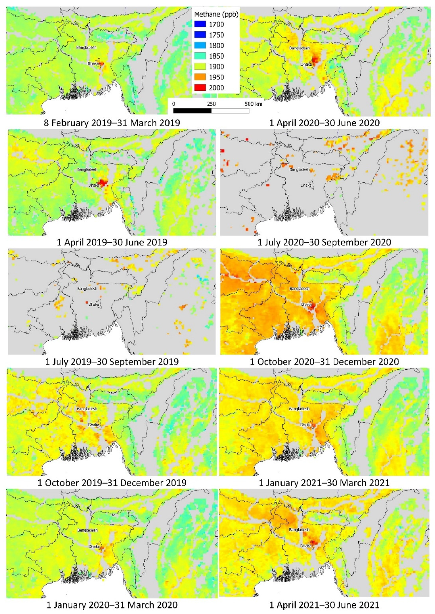
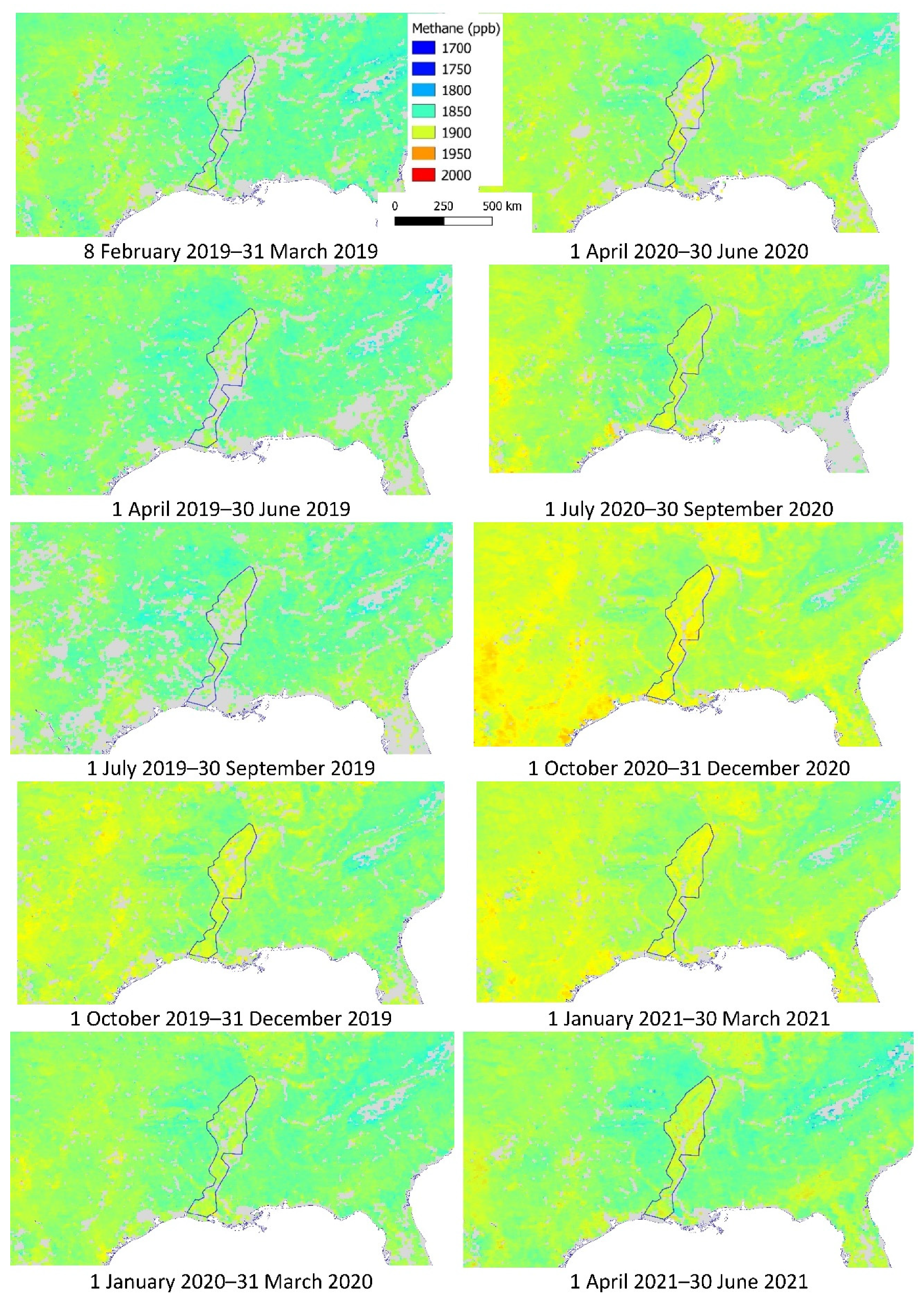
3.3. Spatial-Temporal Variability in CH4 Content for Selected Countries/Regions

Three countries/regions were selected for a more detailed evaluation of spatial-temporal changes in CH4 content during the period of the study. Figure 4, Figure 5 and Figure 6 present spatial-temporal variability by 3-month periods while Figures S2–S4 present maps based on a 1-month period. These countries/regions were selected based on various criteria. The first region is Bangladesh, which is characterized by a very high percentage of rice cultivation area—about 70% of the total country area. Therefore, CH4 emissions from rice fields are very high. However, the highest content of CH4 was observed for the area of the capital city—Dhaka (Figure 4, Figure 7 and Figure S2). Because of the limited availability of data for the third quarter of the year, in years 2019 and 2020, CH4 content for this period can be biased, especially for the results based on 1-month periods. The reason for very limited availability is the monsoon period (from July to September) which is characterized by overcast conditions. The highest CH4 content was observed for the third quarter of the year, especially for October, i.e., for the end of the rice period called “aman”, when most of the rice in Bangladesh is harvested. In most of Bangladesh’s area, the share of rice cultivation area is very high, the exceptions are two regions located next to the coast, i.e., the southwest part where mangrove forests are located and the southeast part with hill forests. In both of these areas, CH4 content is lower in comparison to the CH4 content in other areas of Bangladesh.
Figure 5, Figure 7 and Figure S3 present CH4 content in the main area of rice cultivation in the United States located along the Mississippi River in the mouth of the river and in the lower course of the river (next to the border of Mississippi State with Arkansas and Louisiana). The area of the rice cultivation is interesting because in neighboring areas there is no rice and the effect of the rice cultivation on CH4 content in the atmosphere can be better evaluated. The CH4 content in the atmosphere, in the area of rice cultivation, is higher in comparison to the nearest surrounding area. The differences are most visible during the fourth quarter of the year (September–December) which is the harvest time of the rice, with the maximum value of CH4 in October and November. In other seasons of the year, the differences are visible, but the smallest is observed during the first quarter of the year (January–March).
Spatial-temporal changes of CH4 content in Punjab state (India) are presented in Figure 6, Figure 7 and Figure S4. The highest CH4 content was observed in the third quarter of the year (in the middle of the growing period of rice) with maximum value in September, while the lowest in the first quarter of the year with minimal value in February–March. The lowest CH4 content was observed in the Northeast part of Punjab where the share of the rice area is smaller in comparison to other parts of the Punjab state.

3.4. Relationships between Estimated GHG Emissions and CH4 Content

Correlations between estimated GHG emissions and methane content are presented in Table 1. Most of the correlations are positive, as expected. Some of the correlations are negative but relatively weak. The correlations were calculated separately for each country/region at 42-arc minutes (0.7 degrees) spatial resolution. The strongest positive correlations were observed for Hubei and Hunan (provinces of China), Punjab (state of India), Cambodia, Philippines, and Nepal. Mean correlation coefficients for these regions/countries were between 0.48 and 0.79. For some countries/regions, the correlations were negative.

4. Discussion

The results obtained in this study proved a long-term increase in methane content in studied countries/regions. The mean increase for most of the countries/regions with high rice concentration was about 16 ppb of CH4 per year. Rice is the most important crop in wetlands and pressure to grow rice is increasing. Rice is the only major cereal crop that is grown almost exclusively as food. In view of the growing number of people on earth, world rice production will continue to increase. The results are consistent with CH4 content from corresponding data from Total Carbon Column Observing Network (TCCON) locations [13]. It confirms that CH4 content evaluated on the basis of satellite data from Sentinel-5P is a reliable data source and can be used for the analysis of temporal changes at various spatial scales, including regions and countries.
The increase in CH4 content during the study period is much higher in comparison to previous years which was at a global scale in average in the range from about 0 to about 12 ppb per year in various periods from the 1980s [24,25]. The results of the study of [26] based on in situ measurements, for years 2014–2017, proved a mean yearly global increase in CH4 from 7.0 to 12.7 ppb. A strong global increase in CH4 content in the atmosphere is observed from 2007 and in years 2007–2017 was estimated at about 7 ppb per year. In recent years, the increase is even higher which is very worrying as it can significantly increase the greenhouse effect. In the study of Dalsøren et al. [26], long-term changes of CH4 content during the period 1970–2012 are presented. The study proved quite a high increase in CH4 content in the years 1986–1998, which was about 11 ppb per year. It indicates that the increase in CH4 content is not uniform in longer periods and during the years 1970–2012, long periods with a different increase in CH4 were observed.
Seasonal variability of CH4 content in the study of Nisbet et al. [27]—observed at a global scale—was similar to seasonal variability in this study. The lowest CH4 content was observed at the beginning of the year while the highest was observed in the middle of the year or in autumn. However, the seasonal (within year) amplitude for the countries/regions located in Southeast Asia with high rice concentration was usually higher (50–60 ppb) in comparison to amplitude observed at a global scale (about 40 ppb). A smaller seasonal amplitude of atmospheric CH4 content was observed for the United States where it was equal to about 20 ppb. There are many factors that influence the seasonal variability of CH4 emissions. Firstly, the presence of rice plants enhances the escape of methane from the soil. The main factors controlling the level of CH4 emission during the growing season are positively related to the water level and plant cover. The main controlling factors during the set-aside period are the water level, as well as straw absorption and soil temperature.
The amplitudes observed in Southeast Asia in this study were higher in comparison to the results of Crevoisier et al. [28] for years 2007–2011 where seasonal variations were from about 15 ppb to about 40 ppb depending on the region (higher were observed for Northern Hemisphere than in Southern Hemisphere). Higher seasonal amplitudes of CH4 content in regions of Southeast Asia can be connected with the growing cycle of rice because other anthropological sources of CH4 emissions (e.g., landfills) are more stable in time and are not characterized by high seasonal changes. The most important rice-growing season in Bangladesh is called aman, which starts in April and ends in November or December [29]. In other countries of Southeast Asia, the most important rice vegetation period falls into a similar period, i.e., starts in spring and ends in autumn [30,31]. The highest CH4 content is observed during the intensive growth of rice during aman period. A study by Adhya et al. [30] conducted in Indian conditions proved the highest CH4 emission from rice crop about 2–2.5 months after rice germination or transplantation. Depending on the rice crop calendar, such high emissions are observed in various months but are most often in the monsoon season, i.e., between June and September. The highest CH4 content in the atmosphere in East China falls into the third quarter of the year which is the period of the highest CH4 fluxes from rice paddies [31]. Seasonal compliance of the increases in CH4 content with the rice crop vegetation was also found in the studies of Zhang et al. [4] for various regions of India, China, and Bangladesh, i.e., the highest CH4 content was observed during the most intensive growth of the rice.
Effect of rice cultivation on seasonal variation of CH4 content in the atmosphere is confirmed by observation of the CH4 content in regions where rice is not cultivated. Examples of such areas are South-Western and South-Eastern parts of Bangladesh where forests are located [32]. In these areas, CH4 content is not only lower but seasonal variation of CH4 is much lower in comparison to other parts of Bangladesh where rice is cultivated. A similar pattern of seasonal changes of CH4 content is observed in the Mississippi region, where higher CH4 content and higher seasonal amplitudes are observed for areas with rice cultivation in comparison to neighboring areas where rice is not cultivated.
Most of the correlations evaluated in this study between estimated GHG emissions and CH4 content were positively correlated, which is consistent with expectations. Positive relationships between atmospheric CH4 concentration with the percentage of paddy rice croplands were observed in the study of Zhang et al. [4] for Southeast Asia which confirms that methane emissions from rice fields are substantial and methane atmospheric transport in the horizontal direction is relatively slow. The CH4 content in the study of Zhang et al. [4] was for the periods 2003–2005 and 2007–2009 from SCIAMACHY satellite sensor and for years 2011–2013 from TANSO-FTS satellite sensor. However, some of the correlations were negative. An explanation of negative correlations in the case of some countries/regions such as Bangladesh, Guangdong (province of China), and Bihar (state of India) could be higher CH4 content near to locations of big cities where urban and industrial emissions of CH4 occur [33], while rice crop concentration is rather low. Some negative correlations are difficult to explain, e.g., for Anhui and Jiangsu (provinces of China) and Haryana (state of India).
CH4 from sources of emission, e.g., rice paddies are transported in the atmosphere mainly in the latitudinal direction because of prevailing winds [34]. It is caused by high atmospheric CH4 content in areas where CH4 emission is very low, e.g., in the Sahara Desert, where CH4 is transported from Southeast Asia. Schuck et al. [35] confirm that methane can be transported from South Asia to North Africa. It is difficult to present direct evidence of the transport but similar methane content at the same latitude in Asia and Africa confirms such transport caused by trade winds. Seasonal variation of CH4 over Asia suggests that CH4 content in the atmosphere is strongly influenced by local surface emissions during summer. It confirms that despite long-distance atmospheric transport of CH4, in large part it influences the content of CH4 near sources of emission.
The results obtained in the study prove higher CH4 content in the regions with high rice concentration in comparison to neighboring areas. However, it is difficult to distinguish precisely between CH4 derived from rice crops and other CH4 sources because of atmospheric transport of methane which is difficult to evaluate at high spatial and temporal resolution. However other sources of CH4 (e.g., landfills) are characterized by much lower seasonal variability than CH4 emissions from rice crops and this background CH4 emission is quite stable in time [36,37]. Further studies on the detection of local CH4 anomalies by combining satellite measurements with high-resolution forecasts [38] are necessary, together with higher temporal resolution of the corrected Sentinel 5-P imagery [39] to better evaluate CH4 local and global transport and distinguish various sources of CH4 emission.

5. Conclusions

CH4 content in the atmosphere is characterized by long-term increases and seasonal variability. During the period of the study (2019–2021), the mean yearly increase in CH4 was about 15 ppb for all the studied areas, however, large differences were observed between the countries/regions. The highest increase (about 20 ppb per year) was observed for the Southeast states of India, while the lowest increase was observed for countries located in the Southeast corner of Asia, i.e., Thailand (about 6 ppb per year), Vietnam, and Cambodia (about 12 ppb per year). For most of the other countries/regions, the mean increase in CH4 was in the range from 13 to 18 ppb per year.
Seasonal changes of CH4 content were characterized by the lowest CH4 content at the beginning of the year while the highest content during autumn coincides in time with intensive growth of rice. It indicates that CH4 emissions from paddy fields may have a significant effect on the seasonal variability of the CH4 content in the atmosphere.
Relationships evaluated separately for each country/region proved in most cases positive correlations between CH4 content in the atmosphere with estimated GHG emissions from croplands. This confirms that the CH4 content is higher in areas with a high concentration of rice cultivation compared to neighboring areas. The main limitation of the study is the lack of possibility to distinguish precisely between emissions of CH4 from paddy rice and other agricultural and non-agricultural sources of methane. Moreover, atmospheric transport of CH4 is difficult to evaluate and affects the spatial variability of CH4 content.

Supplementary Materials

The following are available online at https://www.mdpi.com/article/10.3390/atmos12111382/s1, Figure S1: Temporal changes in selected countries/regions and total world (limited to latitudes between 60° S and 60° N) of CH4 content based on Sentinel-5P data (in ppb) and regression equation presenting relationships between CH4 content (y) and subsequent 1-month periods (x)., Figure S2: CH4 content in Bangladesh in subsequent 1-month periods, Figure S3: CH4 content in Mississippi valley (United States) in subsequent 1-month periods, Figure S4: CH4 content in Punjab state (India) in subsequent 1-month periods.

Author Contributions

Conceptualization, K.K., D.G. and E.W.-G.; methodology, K.K.; software, K.K.; validation, K.K.; formal analysis, K.K.; investigation, K.K.; resources, K.K.; data curation, K.K., D.G.; writing—original draft preparation, K.K.; writing—review and editing, K.K., D.G. and E.W.-G.; visualization, K.K. All authors have read and agreed to the published version of the manuscript.

Funding

This research received no external funding.

Institutional Review Board Statement

Not applicable.

Informed Consent Statement

Not applicable.

Conflicts of Interest

The authors declare no conflict of interest.

References

  1. Song, P.; Mansaray, L.R.; Huang, J.; Huang, W. Mapping paddy rice agriculture over China using AMSR-Etime series data. ISPRS J. Photogramm. Remote Sens. 2018, 144, 469–482. [Google Scholar] [CrossRef]
  2. Zhang, B.; Tian, H.; Ren, W.; Tao, B.; Lu, C.; Yang, J.; Pan, S. Methane emissions from global rice fields: Magnitude, spatiotem-poral patterns, and environmental controls. Glob. Biogeochem. Cycles 2016, 30, 1246–1263. [Google Scholar] [CrossRef] [Green Version]
  3. Prasad, R.; Shivay, Y.S.; Kumar, D. Current Status, Challenges, and Opportunities in Rice Production. In Rice Production Worldwide; Chauhan, B., Jabran, K., Mahajan, G., Eds.; Springer: Cham, Switzerland, 2017; pp. 1–32. [Google Scholar]
  4. Zhang, G.; Xiao, X.; Dong, J.; Xin, F.; Zhang, Y.; Qin, Y.; Doughty, R.B.; Moore, B. Fingerprint of rice paddies in spatial–temporal dynamics of atmospheric methane concentration in monsoon Asia. Nat. Commun. 2020, 11, 554. [Google Scholar] [CrossRef] [PubMed] [Green Version]
  5. Singh, V.; Zhou, S.; Ganie, Z.; Valverde, B.; Avila, L.; Marchesan, E.; Bagavathiannan, M. Rice production in the Americas. In Rice Production Worldwide; Springer: Cham, Switzerland, 2017; pp. 137–168. [Google Scholar]
  6. Yodkhum, S.; Gheewala, S.H.; Sampattagul, S. Life cycle GHG evaluation of organic rice production in northern Thailand. J. Environ. Manag. 2017, 196, 217–223. [Google Scholar] [CrossRef] [PubMed]
  7. Boucher, O.; Friedlingstein, P.; Collins, B.; Shine, K.P. The indirect global warming potential and global temperature change potential due to methane oxidation. Environ. Res. Lett. 2009, 4, 044007. [Google Scholar] [CrossRef]
  8. Saunois, M.; Stavert, A.R.; Poulter, B.; Bousquet, P.; Canadell, J.G.; Jackson, R.B.; Zhuang, Q. The global methane budget 2000–2017. Earth Syst. Sci. Data 2020, 12, 1561–1623. [Google Scholar] [CrossRef]
  9. Jacob, D.J.; Turner, A.J.; Maasakkers, J.D.; Sheng, J.; Sun, K.; Liu, X.; Chance, K.; Aben, I.; McKeever, J.; Frankenberg, C. Satellite observations of atmospheric methane and their value for quantifying methane emissions. Atmos. Chem. Phys. 2016, 16, 14371–14396. [Google Scholar] [CrossRef] [Green Version]
  10. Schneising, O.; Buchwitz, M.; Reuter, M.; Bovensmann, H.; Burrows, J.P.; Borsdorff, T.; Deutscher, N.M.; Feist, D.G.; Griffith, D.W.T.; Hase, F.; et al. A scientific algorithm to simultaneously retrieve carbon monoxide and methane from TROPOMI onboard Sentinel-5 Precursor. Atmos. Meas. Tech. 2019, 12, 6771–6802. [Google Scholar] [CrossRef] [Green Version]
  11. Lorente, A.; Borsdorff, T.; Butz, A.; Hasekamp, O.; Schneider, A.; Wu, L.; Hase, F.; Kivi, R.; Wunch, D.; Pollard, D.F.; et al. Methane retrieved from TROPOMI: Improvement of the data product and validation of the first 2 years of measurements. Atmos. Meas. Tech. 2021, 14, 665–684. [Google Scholar] [CrossRef]
  12. Hu, H.; Hasekamp, O.; Butz, A.; Galli, A.; Landgraf, J.; Aan de Brugh, J.; Borsdorff, T.; Scheepmaker, R.; Aben, I. The operational methane retrieval algorithm for TROPOMI. Atmos. Meas. Tech. 2016, 9, 5423–5440. [Google Scholar] [CrossRef] [Green Version]
  13. Sha, M.K.; Langerock, B.; Blavier, J.F.L.; Blumenstock, T.; Borsdorff, T.; Buschmann, M.; Dehn, A.; De Mazière, M.; Deutscher, N.M.; Feist, D.G.; et al. Validation of Methane and Carbon Monoxide from Sentinel-5 Precursor using TCCON and NDACC-IRWG stations. Atmos. Meas. Tech. Discuss. 2021, 14, 6249–6304. [Google Scholar] [CrossRef]
  14. Zhao, R.; Li, Y.; Ma, M. Mapping Paddy Rice with Satellite Remote Sensing: A Review. Sustainability 2021, 13, 503. [Google Scholar] [CrossRef]
  15. Algorithm Theoretical Baseline Document for Sentinel-5 Precursor Methane Retrieval. Available online: https://sentinel.esa.int/documents/247904/2476257/Sentinel-5P-TROPOMI-ATBD-Methane-retrieval (accessed on 12 July 2021).
  16. Hu, H.; Landgraf, J.; Detmers, R.; Borsdorff, T.; Aan de Brugh, J.; Aben, I.; Butz, A.; Hasekamp, O. Toward global mapping of methane with TROPOMI: First results and intersatellite comparison to GOSAT. Geophys. Res. Lett. 2018, 45, 3682–3689. [Google Scholar] [CrossRef]
  17. FAOSTAT. FAOSTAT Food and Agriculture Organization of the United Nations. 2015. Available online: http://www.fao.org/faostat/ (accessed on 5 July 2021).
  18. Ramankutty, N.; Evan, A.T.; Monfreda, C.; Foley, J.A. Farming the planet: 1. Geographic distribution of global agricultural lands in the year 2000. Glob. Biogeochem. Cycles 2008, 22, 1–19. [Google Scholar] [CrossRef]
  19. EarthStat. Available online: http://www.earthstat.org/ (accessed on 24 June 2020).
  20. Google Earth Engine. Sentinel-5P OFFL CH4 Image Collection. Available online: https://developers.google.com/earth-engine/datasets/catalog/COPERNICUS_S5P_OFFL_L3_CH4 (accessed on 24 June 2020).
  21. QGIS Development Team. Geographic Information System. Open Source Geospatial Foundation Project. 2016. Available online: http://www.qgis.org/ (accessed on 5 July 2021).
  22. Carlson, K.M.; Gerber, J.S.; Mueller, N.D.; Herrero, M.; MacDonald, G.K.; Brauman, K.A.; Havlik, P.; O’Connell, C.S.; Johnson, J.A.; Saatchi, S.; et al. Greenhouse gas emissions intensity of global croplands. Nat. Clim. Chang. 2017, 7, 63–68. [Google Scholar] [CrossRef]
  23. STATISTICA (Data Analysis Software System), v. 10; StatSoft, Inc.: Tulsa, OK, USA, 2010; Available online: www.statsoft.com (accessed on 5 July 2021).
  24. Maasakkers, J.D.; Jacob, D.J.; Sulprizio, M.P.; Scarpelli, T.R.; Nesser, H.; Sheng, J.X.; Zhang, Y.; Hersher, M.; Bloom, A.A.; Bowman, K.W.; et al. Global distribution of methane emissions, emission trends, and OH concentrations and trends inferred from an inversion of GOSAT satellite data for 2010–2015. Atmos. Chem. Phys. 2019, 19, 7859–7881. [Google Scholar] [CrossRef] [Green Version]
  25. Global Monitoring Laboratory. Trends in Atmospheric Methane. Global CH4 Monthly Means. 2021. Available online: https://gml.noaa.gov/ccgg/trends_ch4/ (accessed on 12 July 2021).
  26. Dalsøren, S.B.; Myhre, C.L.; Myhre, G.; Gomez-Pelaez, A.J.; Søvde, O.A.; Isaksen, I.S.; Weiss, R.F.; Harth, C.M. Atmospheric me-thane evolution the last 40 years. Atmos. Chem. Phys. 2016, 16, 3099–3126. [Google Scholar] [CrossRef] [Green Version]
  27. Nisbet, E.G.; Manning, M.R.; Dlugokencky, E.J.; Fisher, R.E.; Lowry, D.; Michel, S.E.; Lund, M.C.; Platt, S.M.; Allen, G.; Bousquet, P.; et al. Very strong atmospheric methane growth in the 4 years 2014–2017: Implications for the Paris Agreement. Glob. Biogeochem. Cycles 2019, 33, 318–342. [Google Scholar] [CrossRef]
  28. Crevoisier, C.; Nobileau, D.; Armante, R.; Crépeau, L.; Machida, T.; Sawa, Y.; Matsueda, H.; Schuck, T.; Thonat, T.; Pernin, J.; et al. The 2007–2011 evolution of tropical methane in the mid-troposphere as seen from space by MetOp-A/IASI. Atmos. Chem. Phys. 2013, 13, 4279–4289. [Google Scholar] [CrossRef] [Green Version]
  29. Shelley, I.J.; Takahashi-Nosaka, M.; Kano-Nakata, M.; Haque, M.S.; Inukai, Y. Rice cultivation in Bangladesh: Present scenario, problems, and prospects. J. Int. Coop. Agric. Dev. 2016, 14, 20–29. [Google Scholar]
  30. Adhya, T.K.; Mishra, S.R.; Rath, A.K.; Bharati, K.; Mohanty, S.R.; Ramakrishnan, B.; Rao, V.R.; Sethunathan, N. Methane efflux from rice-based cropping systems under humid tropical conditions of eastern India. Agric. Ecosyst. Environ. 2000, 79, 85–90. [Google Scholar] [CrossRef]
  31. Zhang, Y.; Su, S.; Zhang, F.; Shi, R.; Gao, W. Characterizing spatiotemporal dynamics of methane emissions from rice paddies in northeast China from 1990 to 2010. PLoS ONE 2012, 7, e29156. [Google Scholar] [CrossRef] [PubMed] [Green Version]
  32. Uddin, K.; Matin, M.A.; Meyer, F.J. Operational flood mapping using multi-temporal sentinel-1 SAR images: A case study from Bangladesh. Remote Sens. 2019, 11, 1581. [Google Scholar] [CrossRef] [Green Version]
  33. Parvin, M.; Begum, A. Organic solid waste management and the urban poor in Dhaka city. Int. J. Waste Resour. 2018, 8, 2. [Google Scholar] [CrossRef]
  34. Harris, J.M.; Tans, P.P.; Dlugokencky, E.J.; Masarie, K.A.; Lang, P.M.; Whittlestone, S.; Steele, L.P. Variations in atmospheric methane at Mauna Loa Observatory related to long-range transport. J. Geophys. Res. Atmos. 1992, 97, 6003–6010. [Google Scholar] [CrossRef]
  35. Schuck, T.J.; Ishijima, K.; Patra, P.K.; Baker, A.K.; Machida, T.; Matsueda, H.; Sawa, Y.; Umezawa, T.; Brenninkmeijer, C.A.M.; Lelieveld, J. Distribution of methane in the tropical upper troposphere measured by CARIBIC and CONTRAIL aircraft. J. Geophys. Res. Atmos. 2012, 117, 1–14. [Google Scholar] [CrossRef] [Green Version]
  36. Chakraborty, M.; Sharma, C.; Pandey, J.; Singh, N.; Gupta, P.K. Methane emission estimation from landfills in Delhi: A com-parative assessment of different methodologies. Atmos. Environ. 2011, 45, 7135–7142. [Google Scholar] [CrossRef]
  37. Yan, X.; Cai, Z.; Ohara, T.; Akimoto, H. Methane emission from rice fields in mainland China: Amount and seasonal and spa-tial distribution. J. Geophys. Res. Atmos. 2003, 108, 4505. [Google Scholar] [CrossRef]
  38. Barré, J.; Aben, I.; Agustí-Panareda, A.; Balsamo, G.; Bousserez, N.; Dueben, P.; Engelen, R.; Inness, A.; Lorente, A.; McNorton, J.; et al. Systematic detection of local CH4 anomalies by combining satellite measurements with high-resolution forecasts. Atmos. Chem. Phys. 2021, 21, 5117–5136. [Google Scholar] [CrossRef]
  39. Butz, A.; Galli, A.; Hasekamp, O.; Landgraf, J.; Tol, P.; Aben, I. TROPOMI aboard Sentinel-5 Precursor: Prospective performance of CH4 retrievals for aerosol and cirrus loaded atmospheres. Remote Sens. Environ. 2012, 120, 267–276. [Google Scholar] [CrossRef]
Figure 1. Countries and regions included in the study with percentage of rice area (as percent of total land, own graphics based on the data from http://www.earthstat.org/ (accessed on 5 July 2021)).
Atmosphere 12 01382 g001
Figure 2. Mean CH4 content for the studied period (from 8 February 2019 to 30 June 2021) based on Google Earth Engine https://earthengine.google.com/ (accessed on 5 July 2021).
Atmosphere 12 01382 g002
Figure 3. Temporal changes in selected countries/regions and total world (limited to latitudes between 60° S and 60° N) of CH4 content based on Sentinel-5P data (in ppb) and regression equation presenting relationships between CH4 content (y) and subsequent 3-month periods (x).
Atmosphere 12 01382 g003
Figure 4. CH4 content in Bangladesh in subsequent 3-month periods. Maps were prepared using data from https://earthengine.google.com/ (accessed on 5 July 2021).
Atmosphere 12 01382 g004
Figure 5. CH4 content in Mississippi Valley (United States) in subsequent 3-month periods. Maps were prepared using data from https://earthengine.google.com/ (accessed on 5 July 2021).
Atmosphere 12 01382 g005
Figure 6. CH4 content in Punjab state (India) in subsequent 3-month periods. Maps were prepared using data from https://earthengine.google.com/ (accessed on 5 July 2021).
Atmosphere 12 01382 g006
Figure 7. Mean CH4 content in selected regions (Bangladesh, the United States, and Punjab state—India for all periods of the study—8 February 2019–30 June 2021). Big black dots indicate the largest cities (with population 5 million or greater) and small black dots indicate big cities (with population in range 1–5 million).
Atmosphere 12 01382 g007
Table 1. Mean CH4 content for total period of the study (from 8 February 2019 to 30 June 2021) for studied countries/regions, estimated emissions of GHG from croplands, and correlations between CH4 content and estimated GHG emissions by region/country. Calculated using the data from: http://www.earthstat.org/greenhouse-gas-emissions-croplands/ (accessed on 5 July 2021) and Google Earth Engine https://earthengine.google.com/ (accessed on 5 July 2021) [19].
Country/RegionCountryCH4 Content in Atmosphere (ppb)Estimated GHG Emissions from Croplands (Mg CO2e Per Hectare) *Mean CorrelationMin. CorrelationMax. Correlation
ZhejiangChina1886 4.12 0.280.160.43
JiangxiChina1887 3.84 0.02−0.030.06
HubeiChina1892 3.09 0.790.770.81
AnhuiChina1897 3.26 −0.38−0.47−0.25
JiangsuChina1904 3.25 −0.49−0.53−0.41
HunanChina1886 4.04 0.620.570.68
Guangxi ZhuangChina1889 3.16 0.270.200.36
TaiwanChina1878 2.16 0.43−0.200.76
GuangdongChina1889 3.58 −0.54−0.61−0.48
Andhra PradeshIndia1894 2.09 −0.30−0.40−0.21
AssamIndia1893 2.04 0.250.130.39
BiharIndia1903 3.16 −0.53−0.76−0.41
ChhattisgarhIndia1889 2.53 0.370.180.68
HaryanaIndia1898 2.42 −0.66−0.82−0.53
JharkhandIndia1895 1.65 0.170.060.23
OrissaIndia1893 2.74 0.350.280.44
PunjabIndia1895 4.21 0.480.240.77
Tamil NaduIndia1893 2.00 −0.11−0.370.17
Uttar PradeshIndia1901 2.15 −0.20−0.25−0.11
West BengalIndia1901 3.79 0.420.340.52
Jawa Tengah (Indonesia)1836 8.77 0.140.080.17
Mississippi region (USA)1884 1.69 0.36−0.020.68
Bangladesh1903 3.56 −0.27−0.44−0.10
Sri Lanka1863 5.41 0.25−0.150.70
Cambodia1889 2.47 0.520.450.60
South Korea1872 6.40 −0.06−0.220.16
Myanmar/Burma1877 1.16 0.370.350.38
Nepal1890 1.73 0.630.220.85
Philippines1853 1.76 0.590.040.78
Thailand1889 3.40 0.420.160.53
Vietnam1877 7.51 0.240.180.31
* Significant correlations at 0.05 probability level are in red font. Because of various sample sizes (N) significance of the relationships strongly depends on N used for the analyses and varies between the countries/regions. For countries/regions with larger N critical value of correlation coefficient is lower in comparison to countries/regions where N was lower. Green color indicates low content of CH4 in atmosphere (ppb) and estimated GHG emissions from croplands, while red color indicates high values of these variables. Blue color indicates low values of correlation coefficient (negative correlations), while red color indicates high values (positive correlations).
Table 2. Means of CH4 content for selected countries or regions based on Sentinel-5P data (in ppb) and regression equation presenting relationships between CH4 content (y) and subsequent 3-month periods (x).
Country/RegionCountry8 February–31 March 20191 April–30 June 20191 July–30 September 20191 October–31 December 20191 January–31 March 20201 April–30 June 20201 July–30 September 20201 October–31 December 20201 January–31 March 20211 April–30 June 2021Linear Regression
ZhejiangChina1862187119001888186518771904189818821901y = 2.9·x + 1868.9
JiangxiChina1864187919011879186518861909190018821907y = 3.1·x + 1870.0
HubeiChina1863188119101885187118901915190718861907y = 3.2·x + 1873.9
AnhuiChina1868187919041891187318871926191218891907y = 3.5·x + 1874.3
JiangsuChina1870187719061896187618831926191318931911y = 3.7·x + 1874.7
HunanChina1859186819041881186218831900190518831902y = 3.5·x + 1865.3
Guangxi ZhuangChina1857184519091881186118761901190318821895y = 3.9·x + 1859.7
TaiwanChina18561848189018741859 1944188718891885y = 4.7·x + 1855.8
GuangdongChina1865184519071880186418751925189818861891y = 3.7·x + 1862.9
Andhra PradeshIndia1876187018591907188218871884191919001904y = 4.3·x + 1865.4
AssamIndia1877187819041880187918891912189918971904y = 2.7·x + 1877.0
BiharIndia1867188718931898187918881964193319071909y = 5.6·x + 1871.8
ChhattisgarhIndia1867186718431886187318781912190718911896y = 5.0·x + 1854.3
HaryanaIndia1851188818951893186618841933192018891903y = 4.4·x + 1867.8
JharkhandIndia186918731888189018791881 191818991903y = 4.0·x + 1868.0
OrissaIndia1870186618531891187818771928191318981899y = 5.4·x + 1857.9
PunjabIndia1855188418971895186418781926191318921903y = 4.1·x + 1868.1
Tamil NaduIndia1872187218451919188118881857191019031891y = 3.3·x + 1865.9
Uttar PradeshIndia1863188519041895187518871941192818971904y = 4.4·x + 1873.4
West BengalIndia1875187219131897188518851947192519091906y = 4.5·x + 1876.8
Jawa Tengah (Indonesia)1817182518311838183318341845184018591850y = 3.6·x + 1817.2
Mississippi region (USA)1858186318591881186618781874189218841895y = 3.9·x + 1853.7
Bangladesh1877188019121897188818981938192019101910y = 4.1·x + 1880.5
Sri Lanka1851183518191874186418491836187718771869y = 3.7·x + 1834.6
Cambodia1863184918661878187318611853189118941879y = 3.0·x + 1854.3
South Korea1849185418761865185418641875188518731883y = 3.2·x + 1850.0
Myanmar/Burma1860186718881871186918801916189018811892y = 3.3·x + 1863.5
Nepal1856187218851879186318761976190418941898y = 5.6·x + 1859.2
Philippines1848184618341859186018561846187118721878y = 3.5·x + 1837.5
Thailand1865186219181885188018821874189818951882y = 1.5·x + 1875.7
Vietnam1851185419011879186418671898190118821878y = 3.1·x + 1860.6
India (reference area)1869186618921890187718811934191018931897y = 4.0·x + 1868.7
China (reference area)1838185018711871186018601884188418681879y = 3.6·x + 1846.5
United States (reference area)1844184318461861185318561862187518661871y = 3.4·x + 1839.1
Blue color indicates low values while red color indicates high values of CH4 content.
Publisher’s Note: MDPI stays neutral with regard to jurisdictional claims in published maps and institutional affiliations.

