Identification of Tropical Cyclones’ Critical Positions Associated with Extreme Precipitation Events in Central America

 ,
,  ,
,  and
and 
Abstract
1. Introduction
2. Data and Methodology
3. Results and Discussion
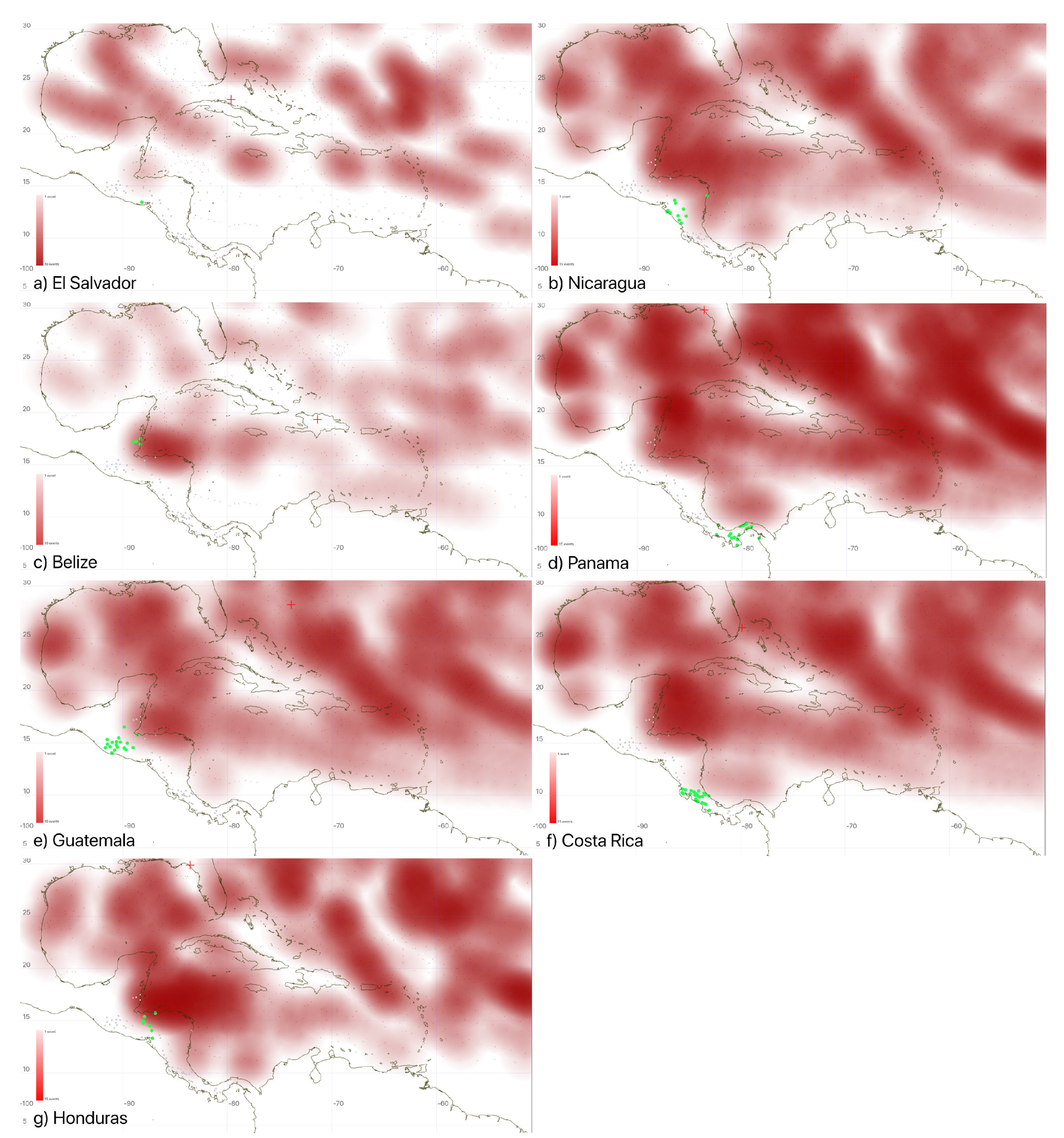
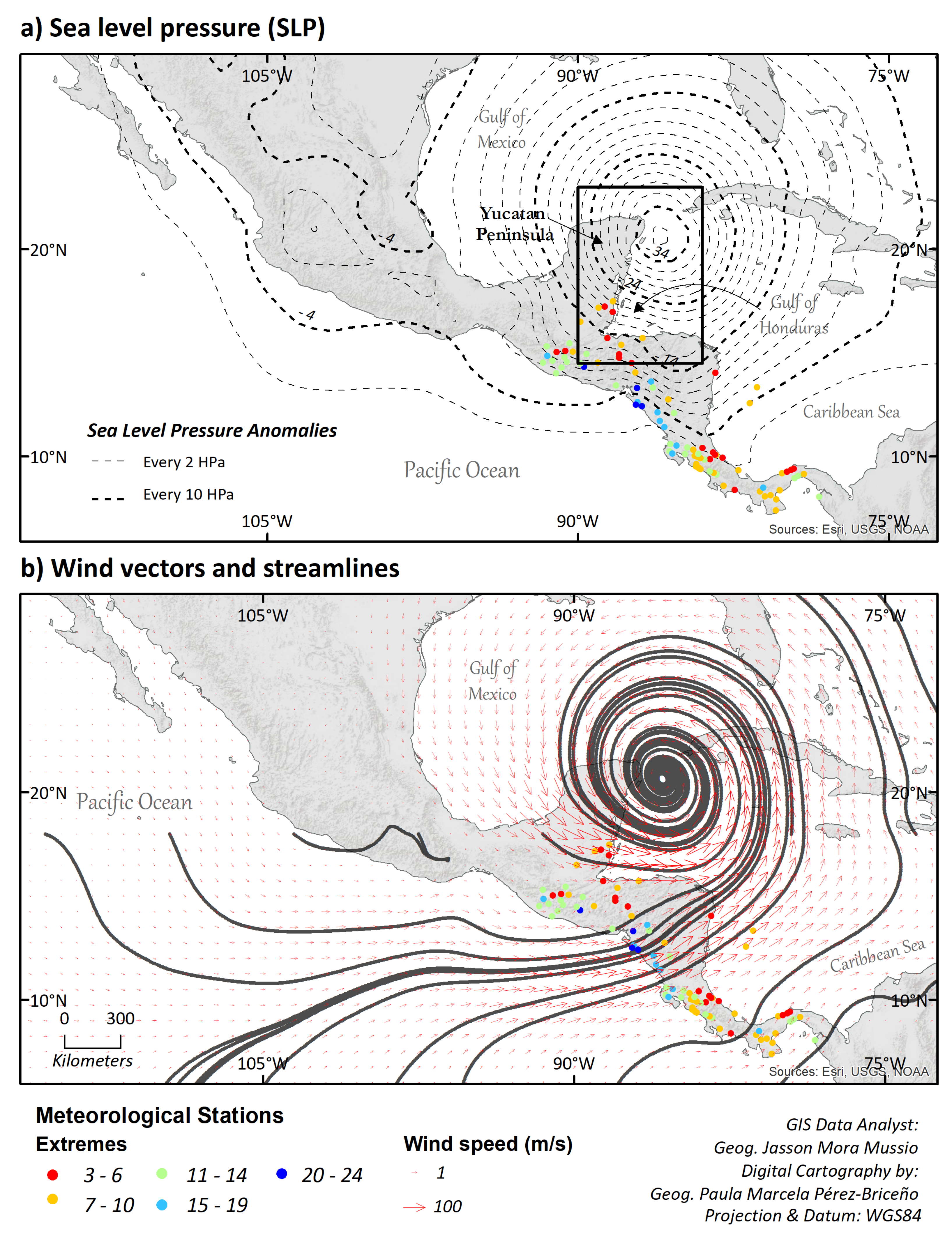
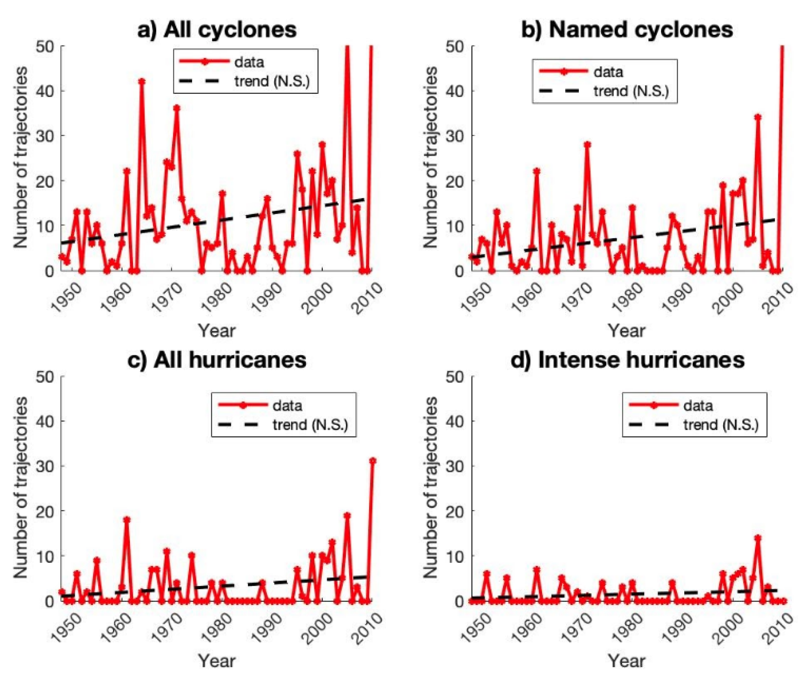
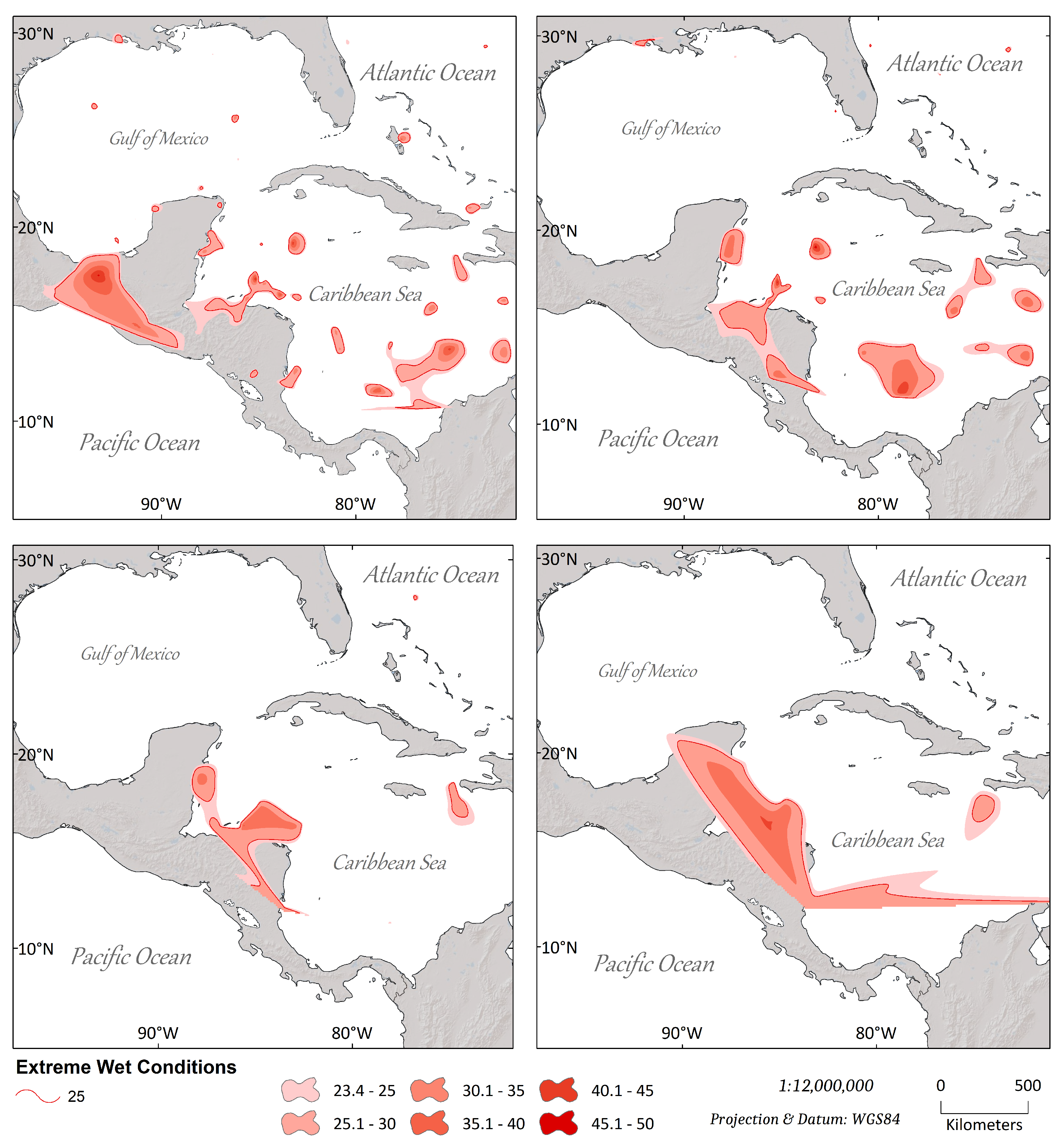
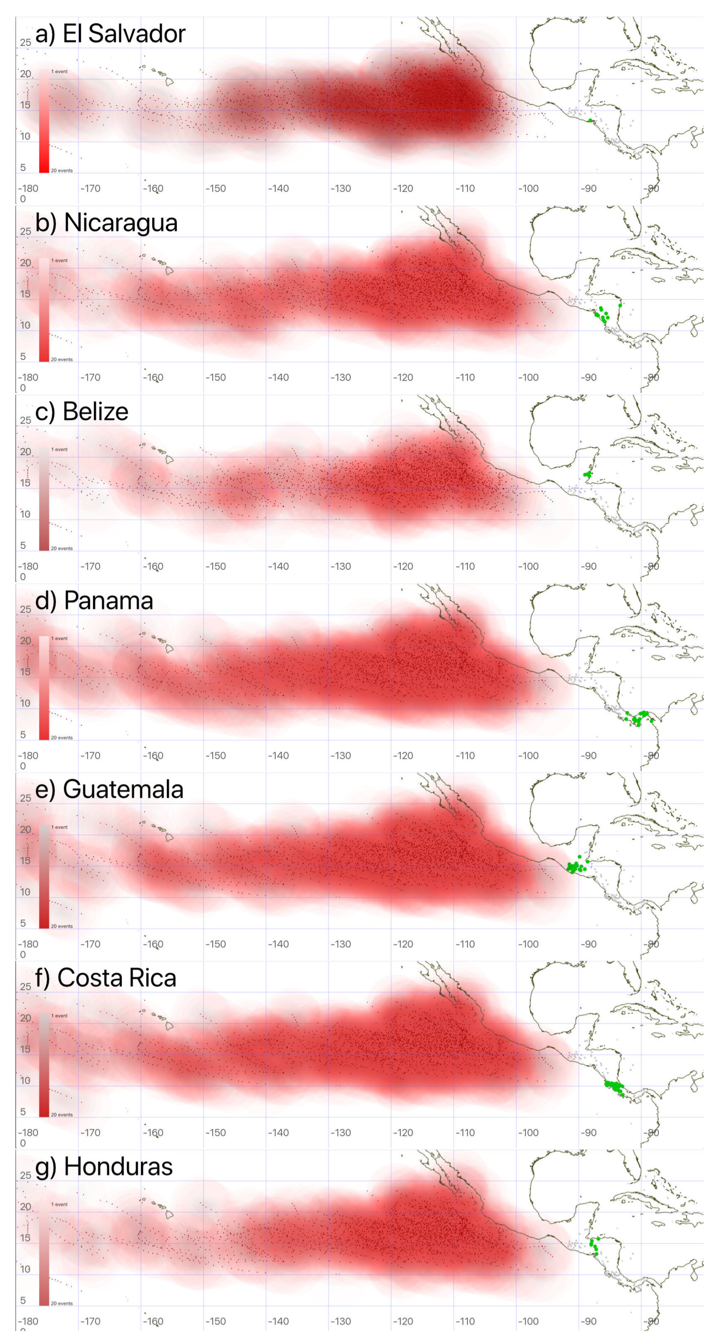
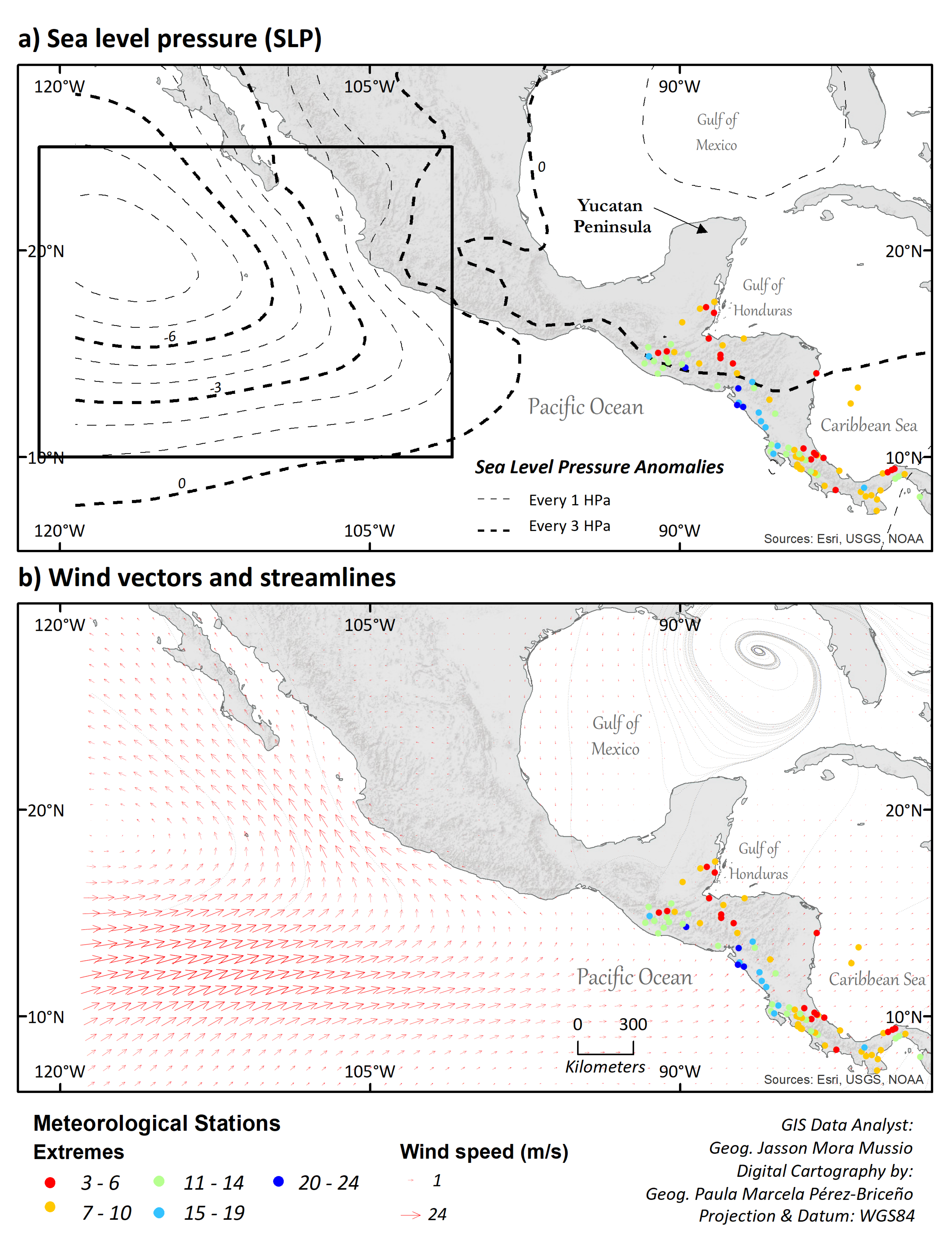
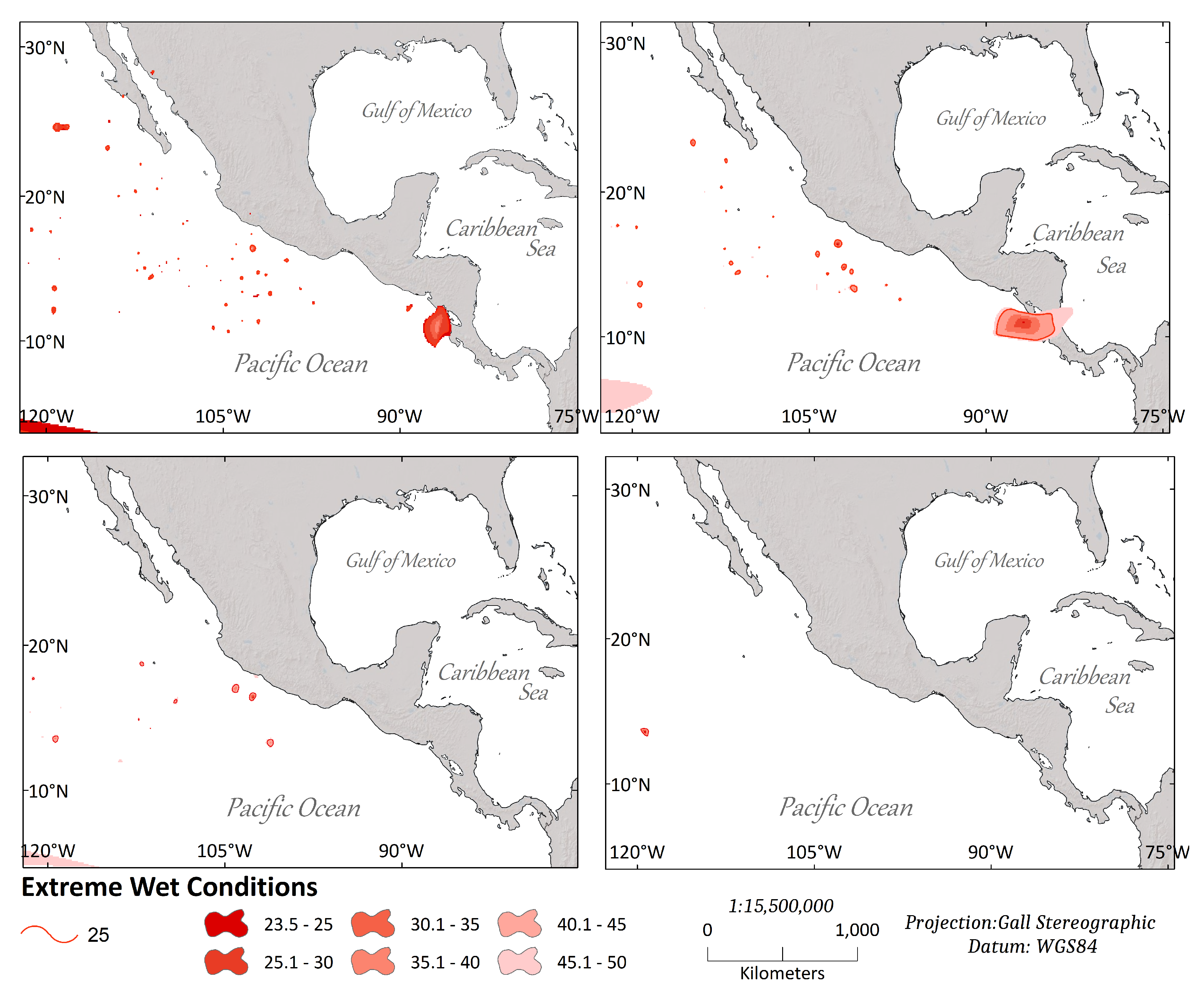
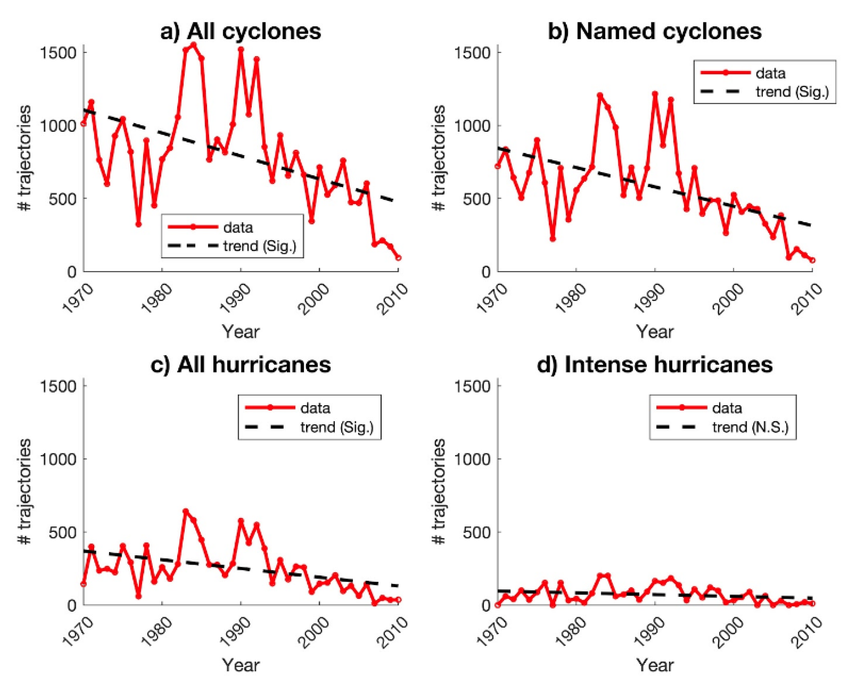
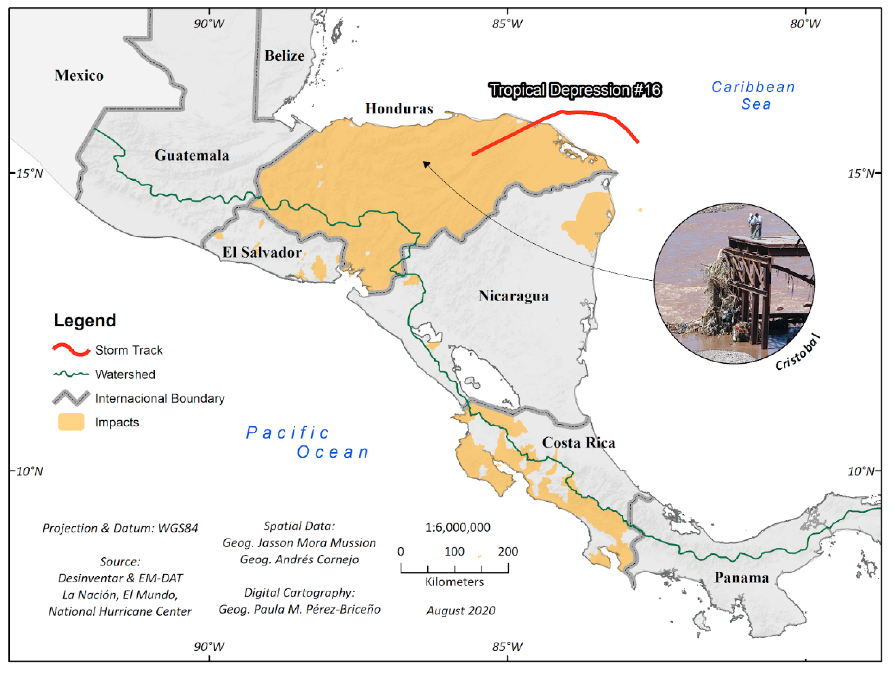
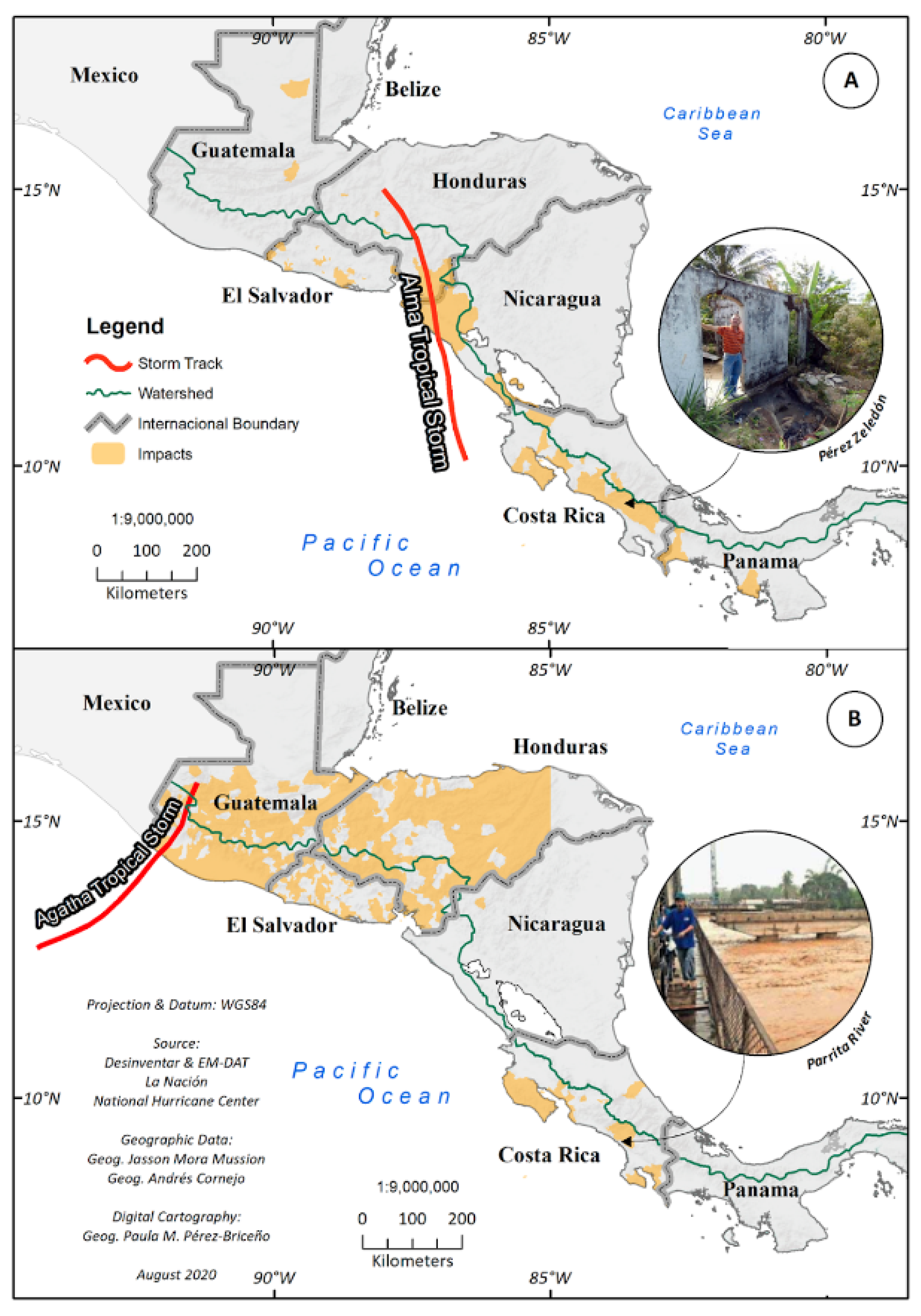
3.1. Caribbean Oceanic Basin Results
3.2. Eastern Tropical Pacific Oceanic Basin Results
4. Conclusions
Author Contributions
Funding
Acknowledgments
Conflicts of Interest
Appendix A


References
- Pérez-Briceño, P.; Alfaro, E.; Hidalgo, H.; Jiménez, F. Distribución espacial de impactos de eventos hidrometeorológicos en América Central. Rev. Climatol. 2016, 16, 63–75. [Google Scholar]
- Alfaro, E.; Pérez-Briceño, P.M. Análisis del impacto de fenómenos meteorológicos en Costa Rica, América Central, originados en los mares circundantes. Rev. Climatol. 2014, 14, 1–11. [Google Scholar]
- Zárate-Hernández, E. Climatología de masas invernales de aire frío que alcanzan Centroamérica y el Caribe y su relación con algunos índices Árticos. Tópicos Meteorológicos y Oceanográficos 2013, 12, 35–55. [Google Scholar]
- Amador, J.; Durán-Quesada, A.M.; Mora, E.R.R.G.; Sáenz, F.; Calderón, B.; Mora, N. The easternmost tropical Pacific. Part II: Seasonal and intraseasonal modes of atmospheric variability. Rev. Biol. Trop. 2016, 64, 23–57. [Google Scholar] [CrossRef]
- Galvin, J.F.P. The weather and climate of the tropics: Part 7—Tropical revolving storms. Weather 2008, 63, 327–333. [Google Scholar] [CrossRef]
- Serra, Y.L.; Jiang, X.; Tian, B.; Amador-Astua, J.; Maloney, E.D.; Kiladis, G.N. Tropical Intraseasonal Modes of the Atmosphere. Annu. Rev. Environ. Resour. 2014, 39, 189–215. [Google Scholar] [CrossRef]
- Peña, M.; Douglas, M.W. Characteristics of Wet and Dry Spells over the Pacific side Central America during the rainy season. Mon. Weather Rev. 2002, 130, 3054–3073. [Google Scholar] [CrossRef]
- Banichevich, A.; Lizano, O. Interconexiones a nivel ciclónico-atmosférico entre las vertientes del Caribe y el Pacífico Centroamericano. Rev. Biol. Trop. 2016, 46, 8–21. [Google Scholar]
- Quesada-Román, A.; Fallas-López, B.; Hernández-Espinoza, K.; Stoffel, M.; Ballesteros-Cánovas, J.A. Relationships between earthquakes, hurricanes, and landslides in Costa Rica. Landslides 2019, 16, 1539–1550. [Google Scholar] [CrossRef]
- Alfaro, E.J.; Hidalgo, H.G.; Maldonado, T.; Pérez-Briceño, P.M.; Mora, N.P. A Tri-dimensional Approach to Climate Sciences. Caribb. Q. 2018, 64, 26–56. [Google Scholar] [CrossRef]
- Fallas, J.C.; Oviedo, R. Fenómenos Atmosféricos y Cambio Climático, Visión Centroamericana: “Temporales”. Cap. III; Instituto Meteorológico Nacional: San José, Costa Rica, 2003; Volume 38. [Google Scholar]
- Díaz, R. La tormenta tropical de 1887 y su paso por las fuentes históricas costarricenses. Rev. Estud. 2004, 18, 39–56. [Google Scholar]
- Simpson, R.; Sugg, A.; Clark, G.; Frank, N.; Hebert, P.; Craft, R.; Pelissier, J. The Atlantic Hurricane season of 1969. Mon. Weather Rev. 1970, 98, 293–306. [Google Scholar] [CrossRef]
- Díaz, R.; Alfaro, E. El impacto social de los Ciclones Tropicales en América Central durante el siglo XX a través del análisis de fuentes hemerográficas. Tópicos Meteorológicos y Oceanográficos 2015, 14, 12–38. [Google Scholar]
- Chaves, F.S.; MartíNez, E.A.; BolañOs, R.D. Análisis del impacto de los ciclones tropicales en la Cuenca del Caribe según fuentes hemerográficas (1870-2007). Revista Tópicos Meteorológicos y Oceanográficos 2015, 14, 46–75. [Google Scholar]
- Alfaro, E.; Quesada, A. Ocurrencia de ciclones tropicales en el Mar Caribe y sus impactos sobre Centroamérica. Rev. Intersedes 2010, 11, 136–153. [Google Scholar]
- Alfaro, E.; Quesada, A.; Solano, F. Análisis del impacto en Costa Rica de los ciclones tropicales ocurridos en el Mar Caribe desde 1968 al 2007. Diálogos 2010, 11, 22–38. [Google Scholar]
- Alvarado, L.; Alfaro, E. Frecuencia de los ciclones tropicales que afectaron a Costa Rica durante el siglo XX. Tópicos Meteorológico y Oceanográficos 2003, 10, 1–11. [Google Scholar]
- Taylor, M.; Alfaro, E. Climate of Central America and the Caribbean. Encycl. World Climatol. 2005, 14, 183–189. [Google Scholar]
- Amador, J.A.; Hidalgo, H.G.; Alfaro, E.J.; Calderón, B.; Mora, N. State of the Climate in 2019. Bull. Am. Meteorol. Soc. 2020, 101, S337–S339. [Google Scholar] [CrossRef]
- Amador, J.A.; Hidalgo, H.G.; Alfaro, E.J.; Calderón, B.; Mora, N. State of the Climate in 2018. Bull. Am. Meteorol. Soc. 2019, 100, S197–S198. [Google Scholar] [CrossRef]
- Amador, J.A.; Hidalgo, H.G.; Alfaro, E.J.; Calderón, B.; Mora, N. State of the Climate in 2017. Bull. Am. Meteorol. Soc. 2018, 99, S99–S200. [Google Scholar] [CrossRef]
- Amador, J.A.; Hidalgo, H.G.; Alfaro, E.J.; Durán-Quesada, A.M.; Calderón, N.M.B.; Arce, D. State of the Climate in 2016. Bull. Am. Meteorol. Soc. 2017, 98, S180–S183. [Google Scholar] [CrossRef]
- Campos-Durán, D.; Quesada-Román, A. Intensive and Extensive Risk in Central America Between 1990 and 2015. Anuário do Instituto de Geociências UFRJ 2017, 40, 234–249. [Google Scholar] [CrossRef]
- Nastos, P.; Papadimou, K.K.; Matsangouras, I. Mediterranean tropical-like cyclones: Impacts and composite daily means and anomalies of synoptic patterns. Atmos. Res. 2018, 208, 156–166. [Google Scholar] [CrossRef]
- Adamson-Bonilla, M. Costa Rica en el Tercer Milenio: Desafíos y Propuestas para la Reducción de la Vulnerabilidad ante Desastres; Universidad de Costa Rica: San José, Costa Rica, 2012; pp. 25–52. [Google Scholar]
- Quesada-Román, A.; Villalobos-Portilla, E.; Campos-Durán, D. Hydrometeorological Disasters in Urban Areas of Costa Rica, Central America. Environ. Hazards 2020, 1–15. [Google Scholar] [CrossRef]
- Dee, D.P.; Uppala, S.M.; Simmons, A.J.; Berrisford, P.; Poli, P.; Kobayashi, S.; Andrae, U.; Balmaseda, M.A.; Balsamo, G.; Bauer, P.; et al. The ERA-Interim reanalysis: Configuration and performance of the data assimilation system. Q. J. R. Meteorol. Soc. 2011, 137, 553–597. [Google Scholar] [CrossRef]
- Landsea, C.W.; Franklin, J.L. Atlantic Hurricane Database Uncertainty and Presentation of a New Database Format. Mon. Weather Rev. 2013, 141, 3576–3592. [Google Scholar] [CrossRef]
- Hernández-Castro, F.; Monge-Fallas, J. Eficiencia comparativa en animaciones en javascript (nota técnica). Tecnología en Marcha 2018, 31, 143–150. [Google Scholar] [CrossRef]
- Mann, H. Non-parametric tests against trend. Econometrica 1945, 13, 163–171. [Google Scholar] [CrossRef]
- Kendall, M.G. Rank Correlation Methods, 4th ed.; Griffin: London, UK, 1975. [Google Scholar]
- Alfaro, E. Escenarios climáticos para temporadas con alto y bajo número de huracanes en el Atlántico. Rev. Climatol. 2007, 7, 1–13. [Google Scholar]
- Amador, J.; Rivera, E.R.; Durán-Quesada, A.M.; Mora, G.; Sáenz, F.; Calderón, B.; Mora, N. The easternmost tropical Pacific. Part I: A climate review. Revista de Biología Tropical 2016, 64, 1–22. [Google Scholar] [CrossRef]
- Chinchilla, G. XXXIII Boletín Meteorológico: Comentario Meteorológico de Octubre de 2008; Instituto Meteorológico Nacional: San Jose, Costa Rica, 2008. [Google Scholar]
- Chinchilla, G.; Quirós, E.; Stolz, W. Boletín Meteorológico: Resumen Meteorológico Mayo de 2010; Instituto Meteorológico Nacional: San Jose, Costa Rica, 2010. [Google Scholar]
- Alfaro, E. Variación de la frecuencia de los ciclones tropicales en el Atlántico y Pacífico Tropical del Este debido a variaciones decadales e interanuales de la Temperatura Superficial del Mar. In Memorias del XI Congreso Latinoamericano e Ibérico de Meteorología y XIV Congreso Mexicano de Meteorología; Federacion Latinoamericana e Iberica de Sociedades de Meteorologia and Organización Mexicana de Meteorólogos: Cancún, Mexico, 2005. [Google Scholar]


| No. | Country | Station Name/Code | Latitude | Longitude | January | February | March | April | May | June | July | August | September | October | November | December |
|---|---|---|---|---|---|---|---|---|---|---|---|---|---|---|---|---|
| 1 | Belice | Pswgia | 17.500 | −88.300 | 0.00 | 0.00 | 0.00 | 0.00 | 0.00 | 0.40 | 1.00 | 0.90 | 1.30 | 1.00 | 0.30 | 0.10 |
| 2 | Costa Rica | Bagaces | 10.533 | −85.250 | 0.00 | 0.00 | 0.00 | 0.00 | 0.00 | 0.60 | 0.10 | 0.40 | 3.00 | 1.49 | 0.00 | 0.00 |
| 3 | Costa Rica | Batan | 10.083 | −83.333 | 1.00 | 0.60 | 0.10 | 0.30 | 1.20 | 1.50 | 3.50 | 1.50 | 0.30 | 0.50 | 2.00 | 2.10 |
| 4 | Costa Rica | Catie | 9.883 | −83.633 | 0.40 | 0.10 | 0.00 | 0.10 | 2.10 | 3.30 | 3.50 | 3.60 | 3.10 | 2.80 | 2.80 | 1.40 |
| 5 | Costa Rica | Ciudad_Quesada | 10.333 | −84.433 | 0.20 | 0.00 | 0.00 | 0.00 | 2.60 | 7.30 | 7.40 | 7.50 | 9.00 | 7.50 | 4.90 | 1.90 |
| 6 | Costa Rica | Coto 47 | 8.602 | −82.968 | 0.00 | 0.00 | 0.00 | 0.50 | 5.59 | 5.10 | 5.80 | 8.00 | 10.20 | 10.20 | 5.90 | 0.00 |
| 7 | Costa Rica | El Carmen | 10.200 | −83.480 | 1.50 | 0.80 | 0.20 | 0.50 | 1.70 | 2.90 | 6.00 | 3.20 | 0.60 | 1.40 | 3.30 | 3.20 |
| 8 | Costa Rica | Fabio Baudrit | 10.000 | −84.250 | 0.00 | 0.00 | 0.00 | 0.00 | 1.90 | 3.00 | 1.00 | 2.30 | 5.40 | 5.00 | 0.20 | 0.00 |
| 9 | Costa Rica | Jilguero | 10.450 | −84.717 | 6.40 | 3.75 | 1.90 | 1.51 | 7.60 | 12.20 | 15.40 | 13.10 | 10.85 | 12.70 | 11.95 | 10.45 |
| 10 | Costa Rica | Juan Sria | 10.000 | −84.217 | 0.00 | 0.00 | 0.00 | 0.00 | 2.40 | 2.90 | 0.80 | 2.30 | 5.55 | 4.70 | 0.20 | 0.00 |
| 11 | Costa Rica | La Argentina | 10.033 | −84.350 | 0.00 | 0.00 | 0.00 | 0.00 | 2.07 | 2.90 | 1.20 | 3.20 | 7.50 | 5.80 | 0.00 | 0.00 |
| 12 | Costa Rica | La Lola | 10.100 | −83.380 | 1.30 | 0.60 | 0.10 | 0.30 | 1.50 | 2.30 | 4.10 | 2.30 | 0.50 | 0.90 | 2.80 | 3.00 |
| 13 | Costa Rica | Liberia | 10.599 | −85.541 | 0.00 | 0.00 | 0.00 | 0.00 | 0.00 | 0.80 | 0.00 | 0.50 | 4.20 | 2.60 | 0.00 | 0.00 |
| 14 | Costa Rica | Limón | 9.950 | −83.017 | 1.80 | 1.10 | 0.40 | 0.70 | 1.20 | 1.70 | 4.70 | 1.70 | 0.20 | 0.60 | 2.05 | 2.90 |
| 15 | Costa Rica | Linda Vista del Guarco +Lankester CIGEFI | 9.850 | −83.900 | 0.00 | 0.00 | 0.00 | 0.00 | 1.30 | 3.10 | 1.30 | 2.60 | 6.10 | 4.20 | 0.30 | 0.00 |
| 16 | Costa Rica | Linda_Vista | 9.933 | −84.083 | 0.00 | 0.00 | 0.00 | 0.00 | 0.00 | 1.20 | 0.00 | 0.50 | 2.45 | 2.30 | 0.00 | 0.00 |
| 17 | Costa Rica | Llorona | 9.400 | −84.083 | 0.00 | 0.00 | 0.00 | 0.00 | 3.60 | 3.80 | 4.04 | 5.60 | 7.60 | 8.00 | 4.20 | 0.00 |
| 18 | Costa Rica | Monteverde | 10.136 | −84.192 | 0.00 | 0.00 | 0.00 | 0.00 | 4.20 | 7.30 | 4.70 | 6.20 | 10.20 | 8.10 | 2.80 | 0.40 |
| 19 | Costa Rica | Monteverde+ Monteverde CIGEFI | 10.133 | −84.825 | 0.70 | 0.40 | 0.20 | 0.10 | 2.00 | 4.20 | 3.40 | 4.90 | 6.70 | 6.10 | 2.45 | 1.40 |
| 20 | Costa Rica | Nicoya | 10.150 | −85.450 | 0.00 | 0.00 | 0.00 | 0.00 | 0.10 | 2.00 | 0.10 | 1.70 | 6.80 | 3.70 | 0.00 | 0.00 |
| 21 | Costa Rica | Palo_Seco | 9.433 | −84.150 | 0.00 | 0.00 | 0.00 | 0.00 | 2.80 | 3.40 | 4.10 | 4.20 | 7.55 | 6.50 | 3.65 | 0.00 |
| 22 | Costa Rica | Piñera | 9.138 | −83.319 | 0.00 | 0.00 | 0.00 | 0.00 | 5.00 | 4.00 | 1.00 | 4.70 | 9.00 | 9.40 | 1.80 | 0.00 |
| 23 | Costa Rica | Playón | 9.533 | −84.300 | 0.00 | 0.00 | 0.00 | 0.00 | 2.20 | 3.10 | 3.40 | 4.00 | 5.00 | 5.50 | 1.50 | 0.00 |
| 24 | Costa Rica | Quepos | 9.461 | −84.159 | 0.00 | 0.00 | 0.00 | 0.00 | 3.80 | 4.00 | 4.60 | 6.00 | 8.00 | 7.20 | 4.00 | 0.00 |
| 25 | Costa Rica | Repunta | 9.300 | −83.650 | 0.00 | 0.00 | 0.00 | 0.00 | 3.90 | 3.50 | 2.50 | 5.00 | 7.40 | 7.40 | 2.60 | 0.00 |
| 26 | Costa Rica | San Miguel | 10.417 | −83.983 | 0.00 | 0.00 | 0.00 | 0.10 | 7.30 | 7.30 | 5.40 | 7.20 | 10.58 | 11.00 | 2.70 | 0.00 |
| 27 | Costa Rica | San_José | 9.633 | −84.283 | 3.00 | 1.60 | 0.30 | 0.90 | 5.30 | 8.00 | 10.50 | 8.90 | 5.90 | 6.80 | 7.20 | 4.80 |
| 28 | Costa Rica | Santa Cruz Balanya | 10.261 | −85.584 | 0.00 | 0.00 | 0.00 | 0.00 | 0.10 | 1.30 | 0.10 | 1.00 | 4.40 | 2.70 | 0.00 | 0.00 |
| 29 | Costa Rica | Volcán Buenos Aires | 9.217 | −83.450 | 0.00 | 0.00 | 0.00 | 0.70 | 6.20 | 4.65 | 2.00 | 5.90 | 10.25 | 11.20 | 3.70 | 0.00 |
| 30 | El Salvador | Ilopango | 13.438 | −88.158 | 0.00 | 0.00 | 0.00 | 0.00 | 0.00 | 0.50 | 0.00 | 0.40 | 2.70 | 0.60 | 0.00 | 0.00 |
| 31 | Guatemala | Asunción Mita | 14.334 | −89.706 | 0.00 | 0.00 | 0.00 | 0.00 | 0.00 | 2.00 | 0.20 | 0.50 | 2.20 | 0.00 | 0.00 | 0.00 |
| 32 | Guatemala | Camotan | 15.044 | −91.024 | 0.00 | 0.00 | 0.00 | 0.00 | 0.00 | 5.20 | 3.80 | 3.60 | 6.10 | 0.30 | 0.00 | 0.00 |
| 33 | Guatemala | Chinique | 15.467 | −90.408 | 0.20 | 0.00 | 0.00 | 0.00 | 0.00 | 4.80 | 3.80 | 3.70 | 4.90 | 2.90 | 0.80 | 0.20 |
| 34 | Guatemala | Coban | 15.109 | −90.614 | 0.00 | 0.00 | 0.00 | 0.00 | 0.00 | 3.30 | 1.22 | 1.60 | 3.20 | 0.10 | 0.00 | 0.00 |
| 35 | Guatemala | El asintal | 17.183 | −89.000 | 0.00 | 0.00 | 0.00 | 0.00 | 0.00 | 0.30 | 1.10 | 0.50 | 0.50 | 0.70 | 0.30 | 0.10 |
| 36 | Guatemala | Esquipulas | 14.533 | −89.033 | 0.00 | 0.00 | 0.00 | 0.00 | 0.00 | 3.30 | 1.10 | 1.60 | 3.70 | 0.20 | 0.00 | 0.00 |
| 37 | Guatemala | Flores | 17.250 | −88.700 | 0.00 | 0.00 | 0.00 | 0.00 | 0.00 | 1.50 | 2.20 | 1.50 | 1.60 | 1.00 | 0.10 | 0.00 |
| 38 | Guatemala | Huehuetenango | 15.317 | −91.503 | 0.00 | 0.00 | 0.00 | 0.00 | 0.00 | 1.90 | 0.10 | 0.20 | 2.15 | 0.00 | 0.00 | 0.00 |
| 39 | Guatemala | Isivumeth | 14.583 | −90.533 | 0.00 | 0.00 | 0.00 | 0.00 | 0.00 | 2.65 | 0.70 | 0.70 | 2.70 | 0.00 | 0.00 | 0.00 |
| 40 | Guatemala | La Ceibita | 14.493 | −89.876 | 0.00 | 0.00 | 0.00 | 0.00 | 0.00 | 0.74 | 0.00 | 0.00 | 1.00 | 0.00 | 0.00 | 0.00 |
| 41 | Guatemala | La Fragua | 14.964 | −89.584 | 0.00 | 0.00 | 0.00 | 0.00 | 0.00 | 0.40 | 0.00 | 0.00 | 0.50 | 0.00 | 0.00 | 0.00 |
| 42 | Guatemala | La Unión | 15.733 | −88.583 | 0.40 | 0.00 | 0.00 | 0.00 | 0.00 | 1.30 | 5.40 | 5.00 | 2.40 | 2.00 | 1.25 | 1.00 |
| 43 | Guatemala | Labor Ovalle | 14.870 | −91.480 | 0.00 | 0.00 | 0.00 | 0.00 | 0.00 | 2.00 | 0.60 | 0.70 | 2.30 | 0.00 | 0.00 | 0.00 |
| 44 | Guatemala | Nebaj | 16.983 | −88.317 | 0.00 | 0.00 | 0.00 | 0.00 | 0.00 | 0.60 | 1.50 | 1.30 | 2.00 | 1.00 | 0.30 | 0.00 |
| 45 | Guatemala | Quezada | 14.535 | −91.678 | 0.00 | 0.00 | 0.00 | 0.00 | 2.52 | 7.17 | 4.00 | 5.20 | 10.79 | 4.07 | 0.00 | 0.00 |
| 46 | Guatemala | Sabana Grande | 14.030 | −91.050 | 0.00 | 0.00 | 0.00 | 0.00 | 2.87 | 8.12 | 7.50 | 8.40 | 12.00 | 7.50 | 0.00 | 0.00 |
| 47 | Guatemala | Sacapulas | 14.301 | −90.786 | 0.00 | 0.00 | 0.00 | 0.00 | 0.00 | 0.80 | 0.20 | 0.40 | 1.00 | 0.00 | 0.00 | 0.00 |
| 48 | Guatemala | San Jerónimo | 16.517 | −89.867 | 0.00 | 0.00 | 0.00 | 0.00 | 0.00 | 1.04 | 1.40 | 1.80 | 2.60 | 0.60 | 0.00 | 0.00 |
| 49 | Guatemala | San Pedro Soloma | 14.632 | −91.231 | 0.00 | 0.00 | 0.00 | 0.00 | 0.10 | 3.85 | 0.70 | 0.80 | 3.10 | 0.00 | 0.00 | 0.00 |
| 50 | Guatemala | Santa Cruz Balanya | 14.801 | −90.640 | 0.00 | 0.00 | 0.00 | 0.00 | 0.00 | 1.10 | 0.60 | 1.00 | 2.10 | 0.00 | 0.00 | 0.00 |
| 51 | Honduras | 78719 | 14.059 | −87.216 | 0.00 | 0.00 | 0.00 | 0.00 | 0.00 | 0.40 | 0.10 | 0.10 | 1.00 | 0.20 | 0.00 | 0.00 |
| 52 | Honduras | Choluteca | 13.318 | −87.154 | 0.00 | 0.00 | 0.00 | 0.00 | 0.10 | 2.20 | 0.00 | 0.50 | 4.95 | 1.00 | 0.00 | 0.00 |
| 53 | Honduras | Jaral | 14.938 | −88.005 | 0.00 | 0.00 | 0.00 | 0.00 | 0.00 | 5.03 | 8.76 | 8.56 | 6.85 | 3.44 | 1.32 | 0.20 |
| 54 | Honduras | La Ceiba | 15.730 | −86.870 | 0.00 | 0.00 | 0.00 | 0.00 | 0.00 | 0.00 | 0.40 | 0.68 | 0.40 | 0.80 | 1.30 | 0.00 |
| 55 | Honduras | La Mesa | 15.400 | −87.900 | 0.00 | 0.00 | 0.00 | 0.00 | 0.00 | 0.00 | 0.20 | 0.20 | 0.29 | 0.10 | 0.00 | 0.00 |
| 56 | Honduras | Pitosolo | 14.780 | −88.010 | 0.00 | 0.00 | 0.00 | 0.00 | 0.00 | 2.50 | 4.50 | 5.60 | 4.23 | 3.00 | 0.60 | 0.00 |
| 57 | Honduras | Sjeronimo | 15.070 | −90.250 | 0.00 | 0.00 | 0.00 | 0.00 | 0.80 | 1.20 | 1.20 | 2.00 | 0.00 | 0.00 | 0.00 | 0.00 |
| 58 | Honduras | Vallecillo | 14.520 | −87.400 | 0.00 | 0.00 | 0.00 | 0.00 | 0.00 | 2.10 | 2.10 | 3.00 | 4.20 | 2.13 | 0.00 | 0.00 |
| 59 | Nicaragua | 45018 | 13.339 | −86.385 | 0.00 | 0.00 | 0.00 | 0.00 | 0.00 | 0.60 | 0.50 | 0.40 | 0.80 | 0.40 | 0.00 | 0.00 |
| 60 | Nicaragua | 55026 | 12.763 | −85.627 | 0.00 | 0.00 | 0.00 | 0.00 | 0.00 | 3.25 | 3.60 | 2.90 | 2.30 | 1.60 | 0.40 | 0.20 |
| 61 | Nicaragua | 60006 | 12.427 | −86.913 | 0.00 | 0.00 | 0.00 | 0.00 | 0.00 | 0.20 | 0.00 | 0.00 | 3.40 | 1.67 | 0.00 | 0.00 |
| 62 | Nicaragua | 61009 | 12.583 | −81.700 | 0.32 | 0.02 | 0.02 | 0.02 | 0.02 | 0.86 | 1.40 | 1.50 | 1.72 | 2.82 | 2.20 | 0.90 |
| 63 | Nicaragua | 61010 | 13.350 | −81.350 | 0.30 | 0.00 | 0.00 | 0.00 | 0.00 | 1.00 | 1.20 | 1.50 | 1.35 | 2.56 | 2.00 | 0.80 |
| 64 | Nicaragua | 61025 | 12.633 | −87.133 | 0.00 | 0.00 | 0.00 | 0.00 | 0.00 | 1.60 | 0.00 | 1.30 | 5.60 | 2.70 | 0.00 | 0.00 |
| 65 | Nicaragua | 69026 | 12.143 | −86.164 | 0.00 | 0.00 | 0.00 | 0.00 | 0.00 | 0.60 | 0.50 | 0.60 | 1.30 | 0.60 | 0.00 | 0.00 |
| 66 | Nicaragua | 69031 | 11.722 | −86.047 | 0.00 | 0.00 | 0.00 | 0.00 | 0.00 | 0.90 | 0.40 | 0.80 | 2.00 | 1.80 | 0.00 | 0.00 |
| 67 | Nicaragua | 69068 | 11.435 | −85.833 | 0.00 | 0.00 | 0.00 | 0.00 | 0.00 | 1.10 | 0.70 | 0.90 | 2.20 | 1.70 | 0.00 | 0.00 |
| 68 | Nicaragua | Corinto | 12.517 | −87.200 | 0.00 | 0.00 | 0.00 | 0.00 | 0.00 | 0.60 | 0.00 | 0.50 | 5.38 | 1.84 | 0.00 | 0.00 |
| 69 | Nicaragua | Juigalpa | 12.100 | −85.367 | 0.00 | 0.00 | 0.00 | 0.00 | 0.00 | 1.00 | 1.10 | 1.00 | 2.10 | 1.10 | 0.00 | 0.00 |
| 70 | Nicaragua | Ocotal | 13.625 | −86.477 | 0.00 | 0.00 | 0.00 | 0.00 | 0.00 | 0.30 | 0.20 | 0.20 | 0.60 | 0.20 | 0.00 | 0.00 |
| 71 | Nicaragua | Puerto Cabezas | 14.047 | −83.375 | 1.10 | 0.20 | 0.00 | 0.00 | 0.20 | 4.20 | 5.60 | 4.90 | 3.00 | 4.00 | 2.71 | 1.80 |
| 72 | Panamá | Agua_Clara | 9.364 | −79.706 | 0.00 | 0.00 | 0.00 | 0.00 | 2.50 | 5.10 | 2.50 | 5.10 | 2.50 | 5.10 | 7.60 | 1.00 |
| 73 | Panamá | Anton | 7.400 | −80.450 | 0.00 | 0.00 | 0.00 | 0.00 | 0.00 | 1.00 | 0.90 | 1.00 | 1.20 | 3.00 | 1.90 | 0.00 |
| 74 | Panamá | Balboa Heights | 8.959 | −79.554 | 0.00 | 0.00 | 0.00 | 0.00 | 0.30 | 1.31 | 0.80 | 2.50 | 2.50 | 2.50 | 2.50 | 0.00 |
| 75 | Panamá | Boca de Toabre | 9.424 | −79.578 | 0.00 | 0.00 | 0.00 | 0.00 | 2.50 | 2.50 | 2.50 | 2.50 | 2.50 | 5.10 | 5.10 | 2.50 |
| 76 | Panamá | Bocas Toro | 9.340 | −82.245 | 1.90 | 1.14 | 0.50 | 1.30 | 1.70 | 2.10 | 4.15 | 2.70 | 0.90 | 1.30 | 2.70 | 3.70 |
| 77 | Panamá | Cerro Punta | 8.508 | −81.073 | 0.00 | 0.00 | 0.00 | 0.00 | 0.70 | 1.70 | 0.80 | 2.00 | 4.20 | 4.40 | 1.80 | 0.20 |
| 78 | Panamá | Cocle del Norte | 8.383 | −80.267 | 0.00 | 0.00 | 0.00 | 0.00 | 0.00 | 0.90 | 0.50 | 0.80 | 0.70 | 2.10 | 1.10 | 0.00 |
| 79 | Panamá | Cuesta de Piedra | 8.065 | −78.366 | 0.00 | 0.00 | 0.00 | 0.00 | 0.00 | 0.50 | 0.00 | 0.50 | 0.40 | 1.00 | 0.00 | 0.00 |
| 80 | Panamá | David | 8.397 | −82.428 | 0.00 | 0.00 | 0.00 | 0.00 | 1.20 | 1.85 | 1.10 | 2.50 | 4.00 | 4.20 | 1.50 | 0.00 |
| 81 | Panamá | Divisa | 8.314 | −81.209 | 0.00 | 0.00 | 0.00 | 0.00 | 1.20 | 3.00 | 0.60 | 2.80 | 7.05 | 7.00 | 1.95 | 0.00 |
| 82 | Panamá | Escandalosa | 9.167 | −79.083 | 0.00 | 0.00 | 0.00 | 0.00 | 1.00 | 2.00 | 1.50 | 2.00 | 2.50 | 4.00 | 2.50 | 0.00 |
| 83 | Panamá | Gatun | 9.268 | −79.921 | 0.00 | 0.00 | 0.00 | 0.00 | 2.50 | 2.50 | 2.50 | 2.50 | 2.50 | 3.00 | 5.10 | 0.50 |
| 84 | Panamá | Icacal | 9.205 | −80.146 | 0.40 | 0.10 | 0.00 | 0.30 | 3.40 | 4.50 | 5.50 | 5.30 | 3.50 | 4.10 | 7.90 | 2.30 |
| 85 | Panamá | Santiago | 8.140 | −80.704 | 0.00 | 0.00 | 0.00 | 0.00 | 0.00 | 0.50 | 0.00 | 0.50 | 1.00 | 2.30 | 1.00 | 0.00 |
| 86 | Panamá | Tocumen | 9.066 | −79.392 | 0.00 | 0.00 | 0.00 | 0.00 | 0.80 | 1.20 | 0.60 | 0.80 | 1.30 | 2.90 | 1.50 | 0.00 |
| 87 | Panamá | Tonosi | 8.087 | −80.978 | 0.00 | 0.00 | 0.00 | 0.00 | 1.50 | 2.20 | 1.10 | 2.50 | 3.60 | 4.60 | 2.50 | 0.00 |
| 88 | Panamá | Valle Rico | 7.941 | −80.418 | 0.00 | 0.00 | 0.00 | 0.00 | 0.00 | 0.20 | 0.00 | 0.00 | 0.30 | 0.70 | 0.00 | 0.00 |
| No. | Country | Station Name/Code | Latitude | Longitude | January | February | March | April | May | June | July | August | September | October | November | December |
|---|---|---|---|---|---|---|---|---|---|---|---|---|---|---|---|---|
| 1 | Belice | Pswgia | 17.500 | −88.300 | 14.28 | 7.60 | 2.78 | 2.35 | 10.34 | 21.25 | 19.00 | 17.80 | 26.35 | 25.14 | 21.60 | 16.00 |
| 2 | Costa Rica | Bagaces | 10.533 | −85.250 | 0.00 | 0.00 | 0.00 | 0.75 | 24.34 | 24.65 | 13.00 | 20.88 | 32.15 | 28.98 | 8.40 | 0.40 |
| 3 | Costa Rica | Batan | 10.083 | −83.333 | 27.80 | 22.48 | 14.74 | 20.75 | 28.58 | 25.20 | 34.98 | 29.44 | 15.40 | 22.84 | 37.90 | 38.47 |
| 4 | Costa Rica | Catie | 9.883 | −83.633 | 15.00 | 14.05 | 7.94 | 13.50 | 24.60 | 27.40 | 25.74 | 25.30 | 25.25 | 22.74 | 26.45 | 25.84 |
| 5 | Costa Rica | Ciudad_Quesada | 10.333 | −84.433 | 27.62 | 16.42 | 7.40 | 11.25 | 33.88 | 40.28 | 46.32 | 42.70 | 42.50 | 43.76 | 40.85 | 44.08 |
| 6 | Costa Rica | Coto 47 | 8.602 | −82.968 | 9.80 | 6.47 | 11.40 | 29.20 | 38.94 | 43.30 | 43.01 | 49.94 | 48.45 | 52.74 | 44.30 | 18.26 |
| 7 | Costa Rica | El Carmen | 10.200 | −83.480 | 31.44 | 24.41 | 18.00 | 22.90 | 32.54 | 31.35 | 41.00 | 33.10 | 21.00 | 28.14 | 46.25 | 48.14 |
| 8 | Costa Rica | Fabio Baudrit | 10.000 | −84.250 | 0.00 | 0.00 | 0.20 | 6.10 | 28.24 | 25.90 | 19.24 | 25.78 | 30.70 | 27.74 | 15.20 | 2.10 |
| 9 | Costa Rica | Jilguero | 10.450 | −84.717 | 38.14 | 33.00 | 23.09 | 21.75 | 37.80 | 43.20 | 44.98 | 43.94 | 36.61 | 42.36 | 43.80 | 55.10 |
| 10 | Costa Rica | Juan Sria | 10.000 | −84.217 | 0.00 | 0.00 | 0.10 | 9.00 | 27.70 | 26.20 | 18.34 | 25.84 | 31.65 | 29.78 | 16.61 | 1.80 |
| 11 | Costa Rica | La Argentina | 10.033 | −84.350 | 0.00 | 0.00 | 0.00 | 3.90 | 28.18 | 27.40 | 23.70 | 29.04 | 34.00 | 31.88 | 16.60 | 1.00 |
| 12 | Costa Rica | La Lola | 10.100 | −83.380 | 29.20 | 25.14 | 16.00 | 21.60 | 34.58 | 29.15 | 37.38 | 32.84 | 19.45 | 25.98 | 40.70 | 42.90 |
| 13 | Costa Rica | Liberia | 10.599 | −85.541 | 0.00 | 0.00 | 0.00 | 0.10 | 24.70 | 28.60 | 17.00 | 28.08 | 37.51 | 30.54 | 11.10 | 0.20 |
| 14 | Costa Rica | Limón | 9.950 | −83.017 | 27.44 | 25.09 | 18.38 | 28.30 | 35.24 | 34.10 | 38.70 | 32.86 | 16.90 | 19.88 | 38.30 | 39.54 |
| 15 | Costa Rica | Linda Vista del Guarco +Lankester CIGEFI | 9.850 | −83.900 | 2.50 | 2.10 | 1.06 | 2.60 | 21.00 | 20.55 | 13.70 | 16.74 | 26.75 | 25.50 | 12.35 | 5.70 |
| 16 | Costa Rica | Linda_Vista | 9.933 | −84.083 | 0.10 | 0.00 | 0.10 | 2.85 | 25.12 | 26.75 | 19.34 | 25.40 | 29.61 | 28.00 | 13.25 | 2.84 |
| 17 | Costa Rica | Llorona | 9.400 | −84.083 | 5.24 | 1.00 | 3.80 | 18.35 | 49.50 | 40.60 | 48.20 | 48.14 | 55.00 | 59.48 | 40.80 | 15.20 |
| 18 | Costa Rica | Monteverde | 10.136 | −84.192 | 12.04 | 7.00 | 4.30 | 14.69 | 39.17 | 40.60 | 33.36 | 38.48 | 48.35 | 46.06 | 34.05 | 20.96 |
| 19 | Costa Rica | Monteverde+ Monteverde CIGEFI | 10.133 | −84.825 | 7.90 | 6.27 | 3.70 | 4.85 | 30.18 | 33.50 | 24.50 | 29.04 | 41.20 | 41.30 | 21.70 | 14.60 |
| 20 | Costa Rica | Nicoya | 10.150 | −85.450 | 0.00 | 0.00 | 0.00 | 4.90 | 29.40 | 30.50 | 25.48 | 35.04 | 37.90 | 37.76 | 14.85 | 0.00 |
| 21 | Costa Rica | Palo_Seco | 9.433 | −84.150 | 4.40 | 0.00 | 3.04 | 19.80 | 48.30 | 43.65 | 48.42 | 50.12 | 60.90 | 57.88 | 42.45 | 17.92 |
| 22 | Costa Rica | Piñera | 9.138 | −83.319 | 1.50 | 1.60 | 9.88 | 25.55 | 43.00 | 40.35 | 37.64 | 45.64 | 47.00 | 50.00 | 29.10 | 7.68 |
| 23 | Costa Rica | Playón | 9.533 | −84.300 | 0.68 | 0.00 | 1.79 | 12.75 | 38.10 | 31.70 | 34.12 | 40.48 | 43.00 | 50.62 | 25.35 | 9.88 |
| 24 | Costa Rica | Quepos | 9.461 | −84.159 | 4.02 | 1.20 | 3.81 | 18.15 | 42.60 | 39.30 | 42.04 | 46.64 | 51.60 | 52.35 | 35.98 | 14.14 |
| 25 | Costa Rica | Repunta | 9.300 | −83.650 | 1.20 | 0.27 | 3.06 | 16.10 | 29.50 | 27.45 | 27.60 | 33.50 | 32.55 | 34.50 | 26.55 | 8.10 |
| 26 | Costa Rica | San Miguel | 10.417 | −83.983 | 27.82 | 23.52 | 16.76 | 22.45 | 35.44 | 42.75 | 45.44 | 41.15 | 35.50 | 36.76 | 41.55 | 44.72 |
| 27 | Costa Rica | San_José | 9.633 | −84.283 | 1.30 | 1.09 | 5.33 | 21.66 | 46.50 | 43.70 | 40.90 | 41.97 | 54.00 | 55.62 | 33.60 | 9.34 |
| 28 | Costa Rica | Santa Cruz Balanya | 10.261 | −85.584 | 0.00 | 0.00 | 0.00 | 2.30 | 23.84 | 28.02 | 19.24 | 27.64 | 35.40 | 33.24 | 10.55 | 0.00 |
| 29 | Costa Rica | Volcán Buenos Aires | 9.217 | −83.450 | 4.04 | 2.87 | 8.54 | 27.95 | 41.20 | 41.85 | 36.04 | 43.64 | 47.65 | 50.38 | 32.25 | 9.95 |
| 30 | El Salvador | Ilopango | 13.438 | −88.158 | 0.00 | 0.00 | 0.00 | 0.20 | 21.80 | 25.20 | 22.50 | 27.32 | 29.75 | 22.38 | 2.25 | 0.00 |
| 31 | Guatemala | Asunción Mita | 14.334 | −89.706 | 0.00 | 0.00 | 0.00 | 0.60 | 17.58 | 30.95 | 22.50 | 23.42 | 28.30 | 16.58 | 0.00 | 0.00 |
| 32 | Guatemala | Camotan | 15.044 | −91.024 | 0.00 | 0.00 | 0.00 | 2.83 | 17.54 | 27.50 | 23.70 | 24.05 | 26.70 | 17.64 | 3.60 | 1.00 |
| 33 | Guatemala | Chinique | 15.467 | −90.408 | 9.51 | 8.84 | 7.14 | 8.70 | 16.24 | 26.65 | 21.00 | 21.70 | 27.55 | 25.16 | 18.45 | 10.10 |
| 34 | Guatemala | Coban | 15.109 | −90.614 | 0.10 | 0.00 | 0.00 | 2.60 | 16.58 | 23.55 | 15.70 | 18.80 | 21.77 | 13.61 | 3.10 | 0.30 |
| 35 | Guatemala | El asintal | 17.183 | −89.000 | 12.48 | 7.60 | 2.74 | 2.00 | 6.10 | 19.25 | 20.18 | 17.00 | 18.26 | 21.92 | 19.80 | 14.46 |
| 36 | Guatemala | Esquipulas | 14.533 | −89.033 | 0.90 | 0.50 | 0.14 | 2.60 | 18.70 | 30.75 | 28.50 | 31.24 | 33.45 | 20.52 | 2.35 | 1.40 |
| 37 | Guatemala | Flores | 17.250 | −88.700 | 14.20 | 7.17 | 4.60 | 3.25 | 9.96 | 27.90 | 27.64 | 23.90 | 27.40 | 25.27 | 24.07 | 17.58 |
| 38 | Guatemala | Huehuetenango | 15.317 | −91.503 | 0.00 | 0.00 | 0.00 | 4.70 | 13.00 | 20.25 | 11.40 | 13.22 | 23.05 | 11.64 | 1.90 | 0.00 |
| 39 | Guatemala | Isivumeth | 14.583 | −90.533 | 0.00 | 0.00 | 0.00 | 1.00 | 12.44 | 24.15 | 18.90 | 18.64 | 24.60 | 12.20 | 1.10 | 0.00 |
| 40 | Guatemala | La Ceibita | 14.493 | −89.876 | 0.00 | 0.00 | 0.00 | 0.00 | 11.74 | 23.40 | 16.64 | 18.12 | 20.40 | 11.00 | 0.20 | 0.00 |
| 41 | Guatemala | La fragua | 14.964 | −89.584 | 0.00 | 0.00 | 0.00 | 0.00 | 8.84 | 18.30 | 12.60 | 13.04 | 15.33 | 6.00 | 0.50 | 0.00 |
| 42 | Guatemala | La Unión | 15.733 | −88.583 | 24.16 | 20.20 | 11.80 | 14.05 | 18.76 | 27.00 | 36.00 | 37.34 | 32.60 | 35.96 | 39.22 | 29.68 |
| 43 | Guatemala | Labor Ovalle | 14.870 | −91.480 | 0.00 | 0.00 | 0.00 | 2.85 | 14.34 | 16.05 | 10.84 | 12.64 | 15.45 | 10.24 | 1.15 | 0.00 |
| 44 | Guatemala | Nebaj | 16.983 | −88.317 | 16.24 | 6.88 | 3.90 | 3.00 | 11.44 | 26.50 | 25.12 | 22.60 | 31.05 | 30.58 | 24.35 | 19.10 |
| 45 | Guatemala | Quezada | 14.535 | −91.678 | 0.00 | 0.00 | 0.20 | 13.00 | 40.48 | 49.59 | 39.00 | 41.00 | 50.10 | 39.14 | 10.80 | 0.00 |
| 46 | Guatemala | Sabana Grande | 14.030 | −91.050 | 0.00 | 0.00 | 2.54 | 20.00 | 46.58 | 55.90 | 46.19 | 49.68 | 56.00 | 51.34 | 16.85 | 0.14 |
| 47 | Guatemala | Sacapulas | 14.301 | −90.786 | 0.00 | 0.00 | 0.00 | 0.40 | 20.39 | 31.65 | 24.48 | 29.18 | 29.77 | 22.00 | 1.85 | 0.00 |
| 48 | Guatemala | San Jerónimo | 16.517 | −89.867 | 7.24 | 3.20 | 1.44 | 2.51 | 11.94 | 23.43 | 20.83 | 20.88 | 25.15 | 22.40 | 15.00 | 9.68 |
| 49 | Guatemala | San Pedro Soloma | 14.632 | −91.231 | 0.00 | 0.00 | 0.00 | 5.65 | 15.88 | 23.80 | 13.21 | 16.64 | 23.00 | 13.34 | 2.00 | 0.00 |
| 50 | Guatemala | Santa Cruz Balanya | 14.801 | −90.640 | 0.00 | 0.00 | 0.00 | 0.37 | 18.60 | 31.40 | 24.42 | 25.82 | 32.07 | 21.97 | 1.35 | 0.00 |
| 51 | Honduras | 78719 | 14.059 | −87.216 | 0.30 | 0.10 | 0.10 | 1.30 | 14.74 | 16.85 | 8.08 | 9.80 | 16.90 | 12.08 | 2.60 | 0.40 |
| 52 | Honduras | Choluteca | 13.318 | −87.154 | 0.00 | 0.00 | 0.00 | 1.60 | 32.14 | 29.10 | 18.68 | 25.14 | 37.60 | 31.42 | 2.35 | 0.00 |
| 53 | Honduras | Jaral | 14.938 | −88.005 | 13.81 | 9.34 | 4.34 | 6.85 | 20.74 | 38.90 | 44.34 | 42.76 | 47.13 | 37.14 | 29.17 | 16.72 |
| 54 | Honduras | La Ceiba | 15.730 | −86.870 | 34.06 | 20.39 | 14.30 | 5.65 | 8.30 | 23.95 | 27.44 | 24.52 | 28.46 | 51.07 | 59.65 | 40.38 |
| 55 | Honduras | La Mesa | 15.400 | −87.900 | 8.05 | 4.50 | 1.04 | 0.65 | 5.74 | 16.31 | 14.86 | 13.50 | 16.00 | 15.70 | 18.15 | 10.09 |
| 56 | Honduras | Pitosolo | 14.780 | −88.010 | 16.39 | 12.11 | 6.28 | 8.15 | 18.04 | 33.63 | 39.22 | 36.66 | 40.90 | 38.80 | 28.57 | 17.68 |
| 57 | Honduras | Sjeronimo | 15.070 | −90.250 | 0.70 | 0.46 | 0.50 | 8.40 | 17.00 | 16.96 | 21.29 | 21.14 | 14.83 | 6.91 | 2.50 | 0.50 |
| 58 | Honduras | Vallecillo | 14.520 | −87.400 | 5.30 | 2.37 | 1.48 | 6.85 | 23.21 | 29.35 | 26.40 | 27.22 | 33.25 | 31.08 | 13.92 | 5.90 |
| 59 | Nicaragua | 45018 | 13.339 | −86.385 | 0.65 | 0.30 | 0.10 | 0.00 | 13.38 | 14.15 | 7.40 | 9.80 | 14.70 | 15.70 | 3.20 | 1.30 |
| 60 | Nicaragua | 55026 | 12.763 | −85.627 | 3.80 | 2.50 | 1.20 | 1.30 | 13.68 | 25.05 | 21.26 | 20.80 | 18.75 | 17.78 | 9.20 | 5.60 |
| 61 | Nicaragua | 60006 | 12.427 | −86.913 | 0.00 | 0.00 | 0.00 | 0.00 | 24.44 | 24.10 | 13.16 | 21.02 | 38.10 | 29.68 | 8.25 | 0.00 |
| 62 | Nicaragua | 61009 | 12.583 | −81.700 | 7.31 | 3.79 | 1.72 | 1.82 | 11.71 | 23.34 | 19.25 | 21.51 | 25.81 | 29.60 | 28.21 | 12.91 |
| 63 | Nicaragua | 61010 | 13.350 | −81.350 | 8.72 | 5.17 | 2.20 | 2.10 | 11.24 | 19.61 | 17.05 | 20.13 | 26.16 | 32.98 | 25.80 | 11.34 |
| 64 | Nicaragua | 61025 | 12.633 | −87.133 | 0.00 | 0.00 | 0.00 | 0.00 | 27.28 | 32.70 | 19.44 | 27.38 | 40.40 | 32.68 | 6.70 | 0.00 |
| 65 | Nicaragua | 69026 | 12.143 | −86.164 | 0.00 | 0.00 | 0.00 | 0.00 | 15.70 | 16.65 | 14.04 | 16.00 | 22.20 | 20.30 | 4.00 | 0.20 |
| 66 | Nicaragua | 69031 | 11.722 | −86.047 | 0.10 | 0.00 | 0.00 | 0.00 | 25.16 | 23.95 | 14.74 | 16.04 | 29.20 | 31.12 | 7.05 | 0.80 |
| 67 | Nicaragua | 69068 | 11.435 | −85.833 | 0.34 | 0.00 | 0.00 | 0.00 | 18.69 | 23.80 | 13.92 | 20.30 | 28.90 | 25.82 | 9.70 | 2.00 |
| 68 | Nicaragua | Corinto | 12.517 | −87.200 | 0.00 | 0.00 | 0.00 | 0.00 | 28.24 | 28.05 | 19.96 | 25.20 | 39.49 | 30.64 | 5.53 | 0.00 |
| 69 | Nicaragua | Juigalpa | 12.100 | −85.367 | 0.80 | 0.30 | 0.00 | 0.00 | 15.98 | 19.60 | 12.71 | 15.34 | 25.65 | 19.20 | 5.40 | 1.30 |
| 70 | Nicaragua | Ocotal | 13.625 | −86.477 | 0.10 | 0.00 | 0.00 | 0.20 | 15.34 | 15.20 | 7.40 | 9.14 | 16.05 | 12.18 | 2.10 | 0.30 |
| 71 | Nicaragua | Puerto Cabezas | 14.047 | −83.375 | 13.34 | 8.47 | 4.50 | 5.15 | 20.04 | 36.53 | 41.86 | 35.00 | 31.90 | 35.08 | 31.50 | 17.20 |
| 72 | Panamá | Agua_Clara | 9.364 | −79.706 | 10.20 | 5.10 | 5.10 | 17.80 | 35.60 | 38.10 | 33.00 | 40.60 | 38.10 | 45.70 | 53.30 | 33.00 |
| 73 | Panamá | Anton | 7.400 | −80.450 | 0.00 | 0.00 | 0.00 | 2.17 | 18.96 | 20.05 | 18.24 | 21.64 | 22.45 | 28.40 | 25.90 | 8.34 |
| 74 | Panamá | Balboa Heights | 8.959 | −79.554 | 2.50 | 0.00 | 0.00 | 7.60 | 23.19 | 22.90 | 21.75 | 21.95 | 20.99 | 27.90 | 27.90 | 15.20 |
| 75 | Panamá | Boca de Toabre | 9.424 | −79.578 | 10.20 | 7.60 | 5.67 | 20.30 | 33.00 | 33.00 | 33.00 | 30.50 | 27.90 | 30.50 | 43.20 | 30.50 |
| 76 | Panamá | Bocas Toro | 9.340 | −82.245 | 24.45 | 20.30 | 16.94 | 26.55 | 31.02 | 28.85 | 34.02 | 29.54 | 20.40 | 21.24 | 32.25 | 38.00 |
| 77 | Panamá | Cerro Punta | 8.508 | −81.073 | 3.34 | 1.90 | 1.44 | 6.00 | 24.04 | 28.40 | 22.58 | 28.14 | 33.05 | 33.64 | 24.75 | 10.44 |
| 78 | Panamá | Cocle del Norte | 8.383 | −80.267 | 0.00 | 0.00 | 0.00 | 1.95 | 16.68 | 19.75 | 19.70 | 19.78 | 20.45 | 25.94 | 24.80 | 8.84 |
| 79 | Panamá | Cuesta de Piedra | 8.065 | −78.366 | 0.40 | 0.00 | 0.00 | 4.39 | 17.68 | 16.75 | 16.27 | 17.34 | 17.86 | 26.17 | 22.38 | 10.61 |
| 80 | Panamá | David | 8.397 | −82.428 | 0.60 | 0.00 | 1.00 | 9.10 | 33.60 | 33.60 | 31.24 | 34.94 | 37.75 | 36.14 | 27.95 | 7.50 |
| 81 | Panamá | Divisa | 8.314 | −81.209 | 0.00 | 0.00 | 0.00 | 7.80 | 37.94 | 37.00 | 32.86 | 43.54 | 46.84 | 46.44 | 33.45 | 8.10 |
| 82 | Panamá | Escandalosa | 9.167 | −79.083 | 1.00 | 0.50 | 0.50 | 5.50 | 27.20 | 26.50 | 21.20 | 25.50 | 31.50 | 38.50 | 31.50 | 11.00 |
| 83 | Panamá | Gatun | 9.268 | −79.921 | 7.60 | 5.10 | 2.50 | 16.35 | 30.50 | 27.90 | 27.90 | 30.75 | 28.21 | 33.00 | 40.60 | 25.40 |
| 84 | Panamá | Icacal | 9.205 | −80.146 | 10.66 | 5.64 | 5.64 | 19.60 | 42.28 | 36.80 | 42.34 | 36.90 | 35.85 | 41.84 | 53.95 | 37.28 |
| 85 | Panamá | Santiago | 8.140 | −80.704 | 0.00 | 0.00 | 0.00 | 0.80 | 23.54 | 23.75 | 17.08 | 21.88 | 27.40 | 28.82 | 24.00 | 4.74 |
| 86 | Panamá | Tocumen | 9.066 | −79.392 | 0.30 | 0.00 | 0.00 | 5.75 | 24.34 | 25.00 | 19.14 | 22.94 | 26.00 | 31.30 | 27.10 | 11.64 |
| 87 | Panamá | Tonosi | 8.087 | −80.978 | 0.20 | 0.00 | 0.00 | 11.30 | 34.30 | 32.15 | 25.14 | 35.00 | 35.42 | 37.84 | 29.90 | 8.98 |
| 88 | Panamá | Valle Rico | 7.941 | −80.418 | 0.00 | 0.00 | 0.00 | 0.00 | 10.88 | 13.85 | 8.54 | 11.68 | 17.05 | 23.68 | 13.95 | 2.40 |
| Category | Windspeed [km/h] | Damage |
|---|---|---|
| Five (major) | >252 | Catastrophic |
| Four (major) | 209–251 | Catastrophic |
| Three (major) | 178–208 | Devastating |
| Two | 154–177 | Extremely dangerous |
| One | 119–153 | Very dangerous |
| Tropical storm | 63–118 | - |
| Tropical depression | <62 | - |
Publisher’s Note: MDPI stays neutral with regard to jurisdictional claims in published maps and institutional affiliations. |
© 2020 by the authors. Licensee MDPI, Basel, Switzerland. This article is an open access article distributed under the terms and conditions of the Creative Commons Attribution (CC BY) license (http://creativecommons.org/licenses/by/4.0/).
Share and Cite
Hidalgo, H.G.; Alfaro, E.J.; HernÃandez-Castro, F.; Pérez-Briceño, P.M. Identification of Tropical Cyclones’ Critical Positions Associated with Extreme Precipitation Events in Central America. Atmosphere 2020, 11, 1123. https://doi.org/10.3390/atmos11101123
Hidalgo HG, Alfaro EJ, HernÃandez-Castro F, Pérez-Briceño PM. Identification of Tropical Cyclones’ Critical Positions Associated with Extreme Precipitation Events in Central America. Atmosphere. 2020; 11(10):1123. https://doi.org/10.3390/atmos11101123
Chicago/Turabian StyleHidalgo, Hugo G., Eric J. Alfaro, Franklin HernÃandez-Castro, and Paula M. Pérez-Briceño. 2020. "Identification of Tropical Cyclones’ Critical Positions Associated with Extreme Precipitation Events in Central America" Atmosphere 11, no. 10: 1123. https://doi.org/10.3390/atmos11101123
APA StyleHidalgo, H. G., Alfaro, E. J., HernÃandez-Castro, F., & Pérez-Briceño, P. M. (2020). Identification of Tropical Cyclones’ Critical Positions Associated with Extreme Precipitation Events in Central America. Atmosphere, 11(10), 1123. https://doi.org/10.3390/atmos11101123