1. Introduction
As one of the most important indicators in understanding the interactions between human activities and the environment [
1,
2], land use and land cover change (LULCC) plays a pivotal role in global ecological and environmental changes [
3,
4,
5,
6,
7]. LULCC analysis is an important tool for assessing global change at various spatial and temporal scales [
3]. LULCC could have significant impacts on a number of interrelated biogeochemical processes and eventually lead to global change [
8]. Human activities play a pivotal role in LULCC [
9]. Both anthropogenic factors and natural factors play an important role in LULCC; however, anthropogenic LULCC is now unprecedentedly large, profoundly affecting the Earth’s ecological systems [
1,
9]. Human-induced LULCC affects key aspects of earth system functioning and it has a significant negative impact on ecosystems [
5]. For instance, it influences the global carbon cycle, and contributes to the increase in atmospheric CO
2 [
10]. It is therefore important to study LULCC, so that its effects on terrestrial ecosystems can be discerned and sustainable land use planning can be carried out [
11]. Additionally, quantification of the role of humans in LULCC is important for predicting land use changes as well as promoting the sustainable use of land resources [
12,
13,
14], especially in ecologically fragile regions. However, research that quantifies of the role of humans in LULCC is still rare.
Previous studies typically used the bitemporal detection method to analyze spatiotemporal changes between pairs of time periods [
5,
6,
7,
8]. Trajectory analysis can recover the history of land cover change and can also relate the spatiotemporal pattern of such changes to other environmental and human factors [
15,
16]. It can also effectively analyze the trends of land use and land cover change over time [
17,
18]. Attempts have been made to apply a trajectory analysis method for assessing LULCC over multiple points in time [
15,
16,
17,
18,
19,
20,
21]. To better understand land degradation progress and study the impact of human activities on the changes in natural environment, trajectory analysis was used in this study.
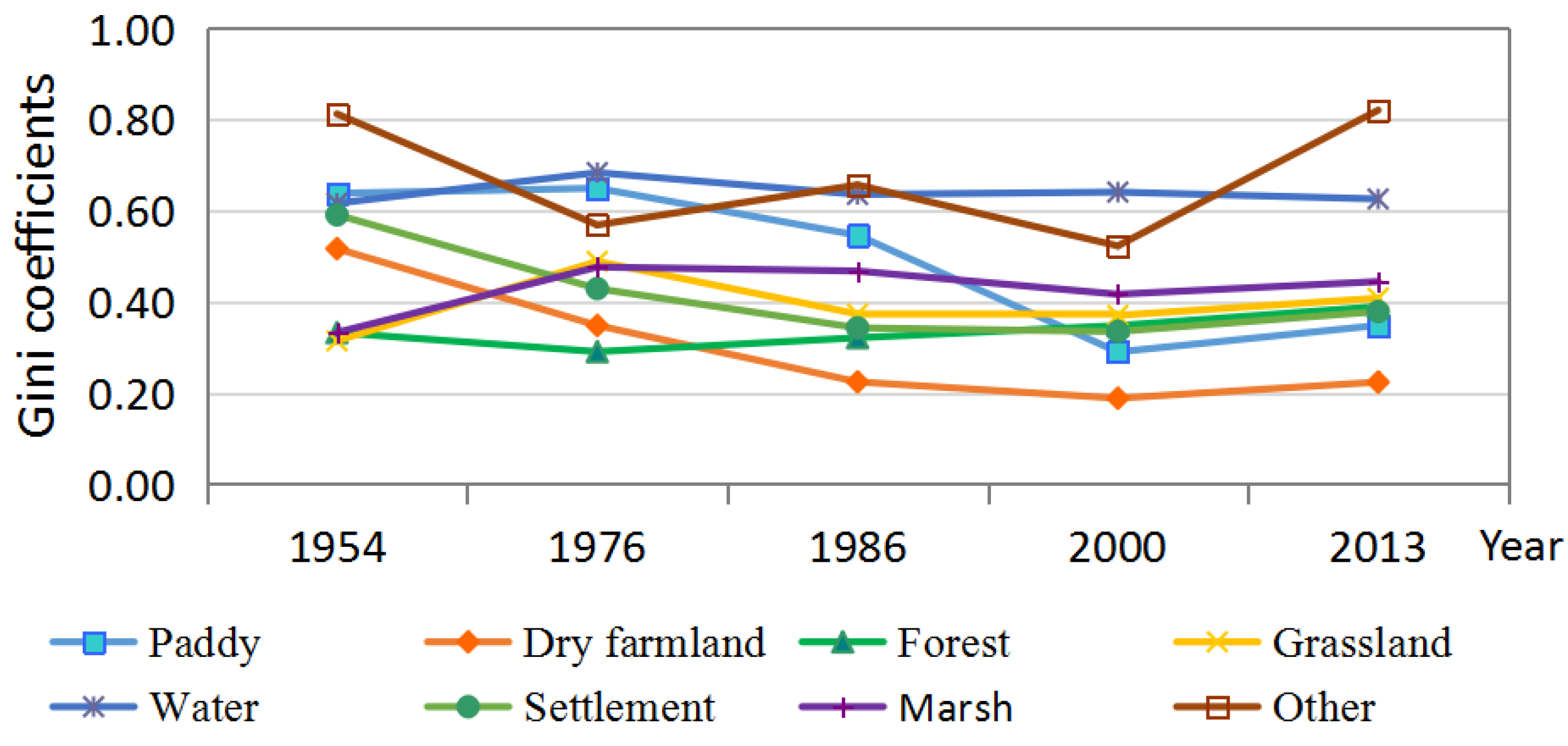
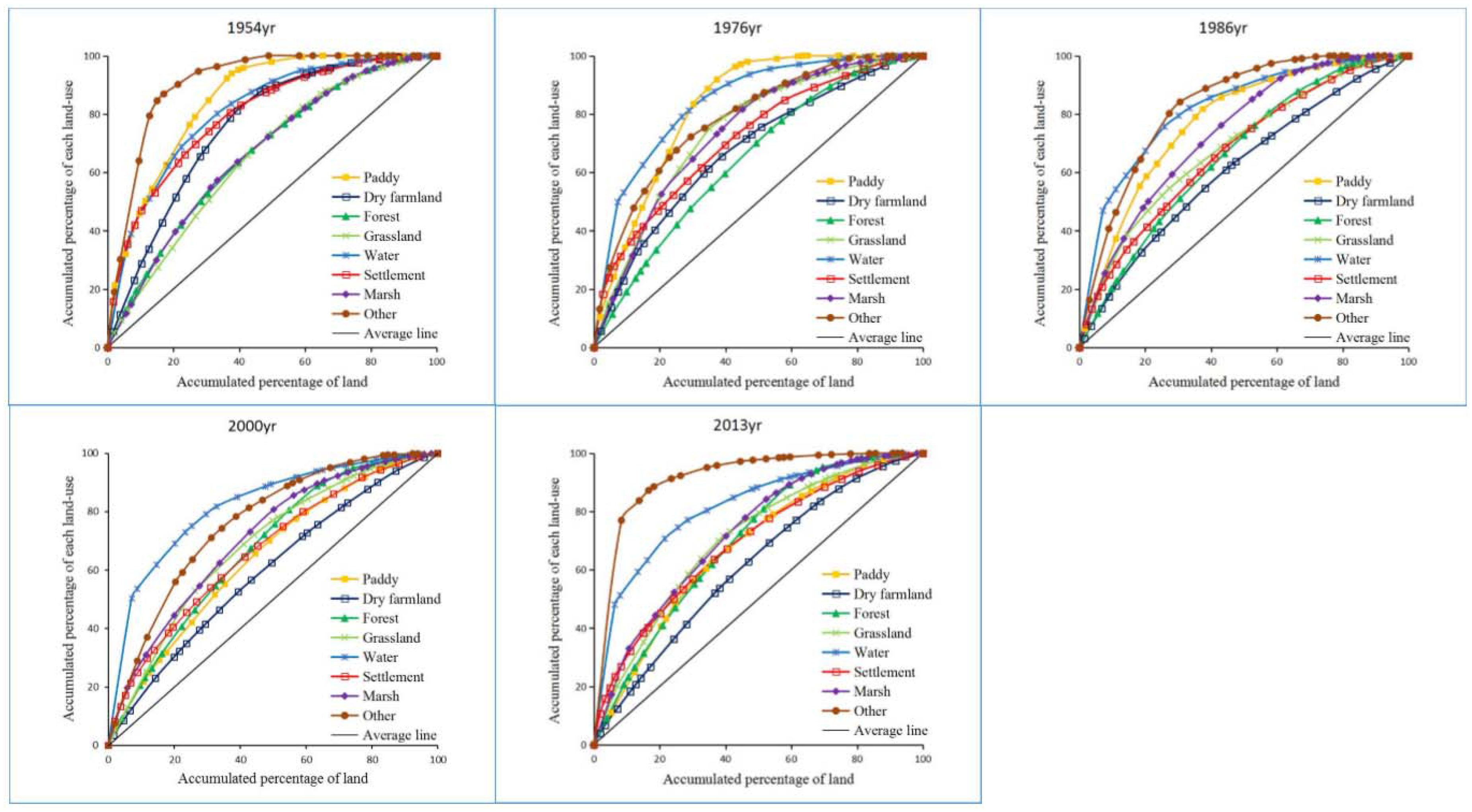
Land use structure could reflect the geographic configuration and comparison of different land use types [
22]. Analyzing land use structure could help us better understand the relationship between land use and ecosystems, as well as the regional differences in the proportions of certain land use types [
22,
23]. Many methods have been used in studying land use structure, such as the artificial neural networks (ANN) [
24,
25], information entropy [
26], optimal linear programming methods [
27], and the Lorenz curve and the associated Gini coefficient [
28,
29]. The Lorenz curve originated from economics models and has been applied in many fields. The Lorenz curve and Gini coefficient can reveal and quantify the changes in land use structure and are simpler than other methods [
22,
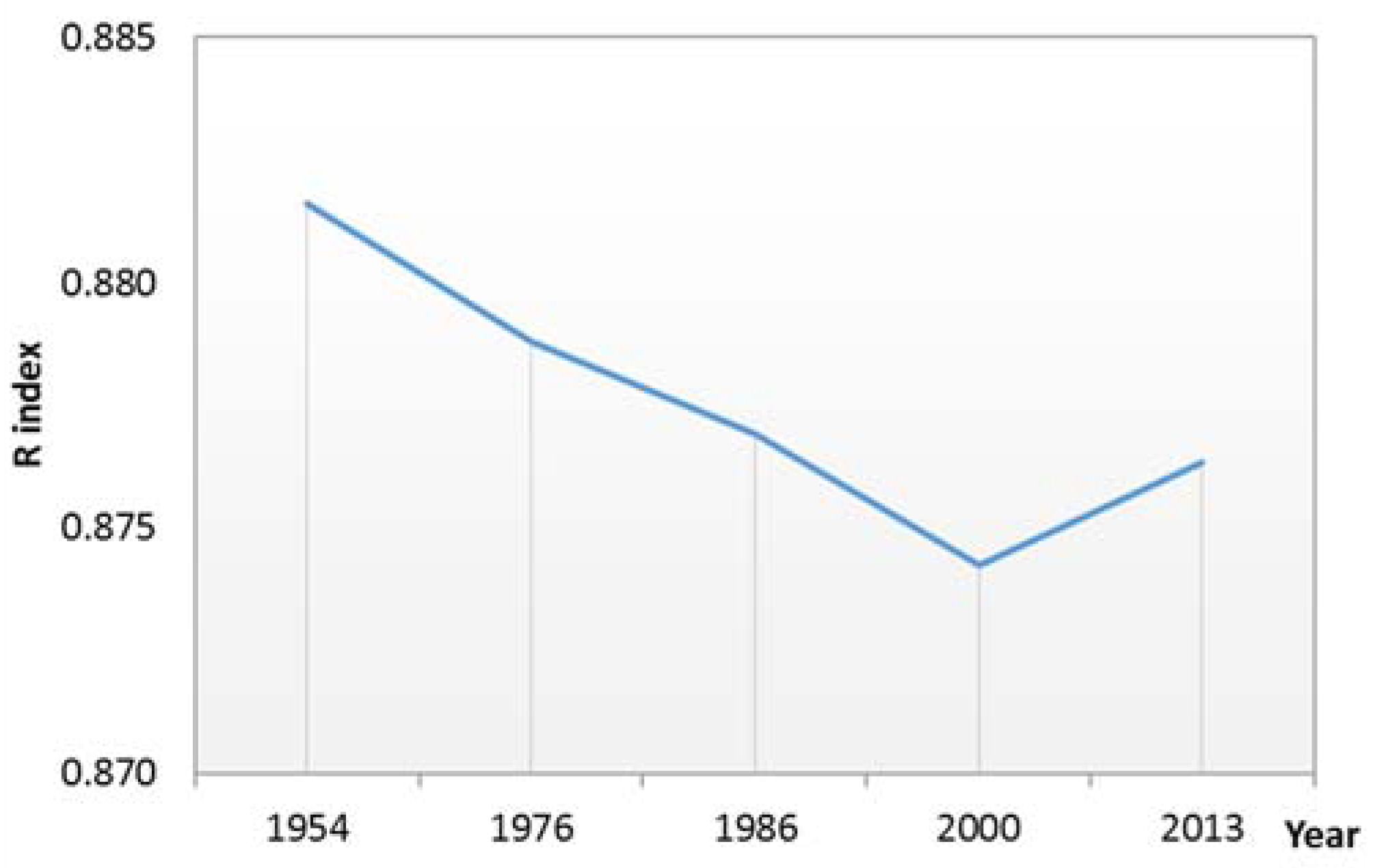
29]. The relative land-use suitability index (R) [
16,
30] can be used to assess the suitability of land-use structure. Larger R-values mean that the land use structure is more suitable than lower values. In this study, the Lorenz curve, Gini coefficient and R index were combined to analyze the land use structure of Sanjiang Plain.
Ecosystem services represent the benefits that living organism derived from ecosystem functions, which are necessary for human well-being, health, livelihoods, and survival [
31,
32,
33,
34]. Ecosystems supply goods that are necessary for human survival; maintain the earth’s life support systems; and provide entertainment for human beings [
35,
36]. Since the United Nations published its Millennium Ecosystem Assessment, many ecologists and economists have paid greater attention to the concept of ecosystem services [
37,
38] and interest in ecosystem services values (ESV) has grown quickly [
38,
39]. Various methods have been developed to estimate ESV [
23,
40,
41,
42,
43,
44]. By summarizing literature, Costanza et al. [
31] grouped the ecosystem services into 10 biomes and classified the ecosystem services into 17 types to calculate global ESV. This method provides a reference for assessing ESV comprehensively [
45] and has been applied successfully to specific areas, species, and ecosystems [
37,
46]. By surveying more than 200 ecologists from China, Xie et al. [
43,
47,
48] modified the evaluation model proposed by Costanza to meet China’s specific situation. The table of ESV per unit area of different ecosystems proposed by Xie et al. is comprehensive and specific to China [
34,
45]. As a type of human-made wetland, the ESV of paddy field are quite different from those of dry farmland. However, there are still no standard estimates of ESV per unit area for paddy or dry farmland. Considering this situation and the specific condition of Sanjiang Plain, we modified Xie’s table based on net primary productivity (NPP) [
34,
49].
Dramatic land degradation often affects ecosystems services negatively [
50]. Few studies have evaluated the impact of LULCC on ESV with the goal of providing useful insights into landscape planning and sustainable use of land resources [
51,
52]. Integrating LULCC and ESV into landscape planning for sustainable development is still a challenge [
51,
53,
54,
55]. As the largest freshwater marsh in China, Sanjiang Plain is vulnerable to global change and human disturbance. High-intensity human activities, especially large-scale reclamation, have led to intensive land degradation since the 1950s in this region [
56,
57,
58,
59]. Meanwhile, climate change [
60], elevated atmospheric CO
2 [
61], and other natural factors [
59] have also caused some degree of land degradation in this region. Many studies [
56,
57,
58,
62,
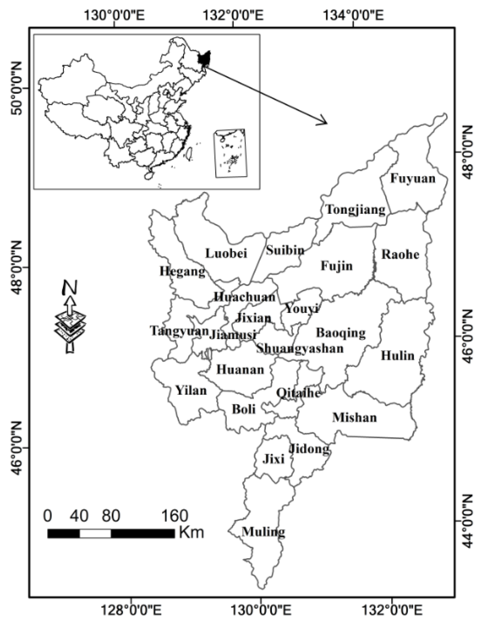
63] have examined spatiotemporal changes in land degradation and its driving factors over part or all of Sanjiang Plain. However, information on the land use structure changes and quantitative analysis of human impacts are still lacking for this area. Song et al. [
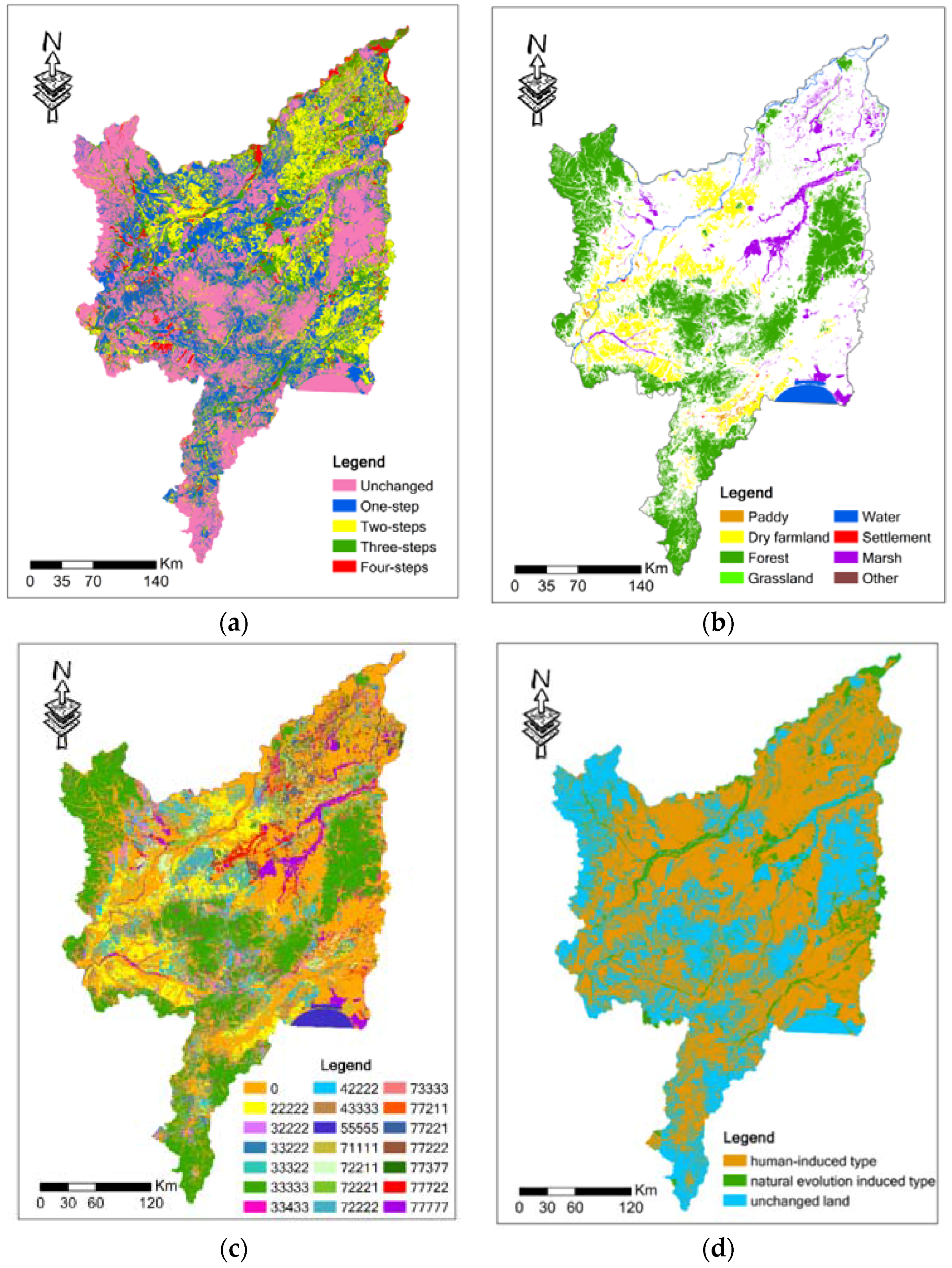
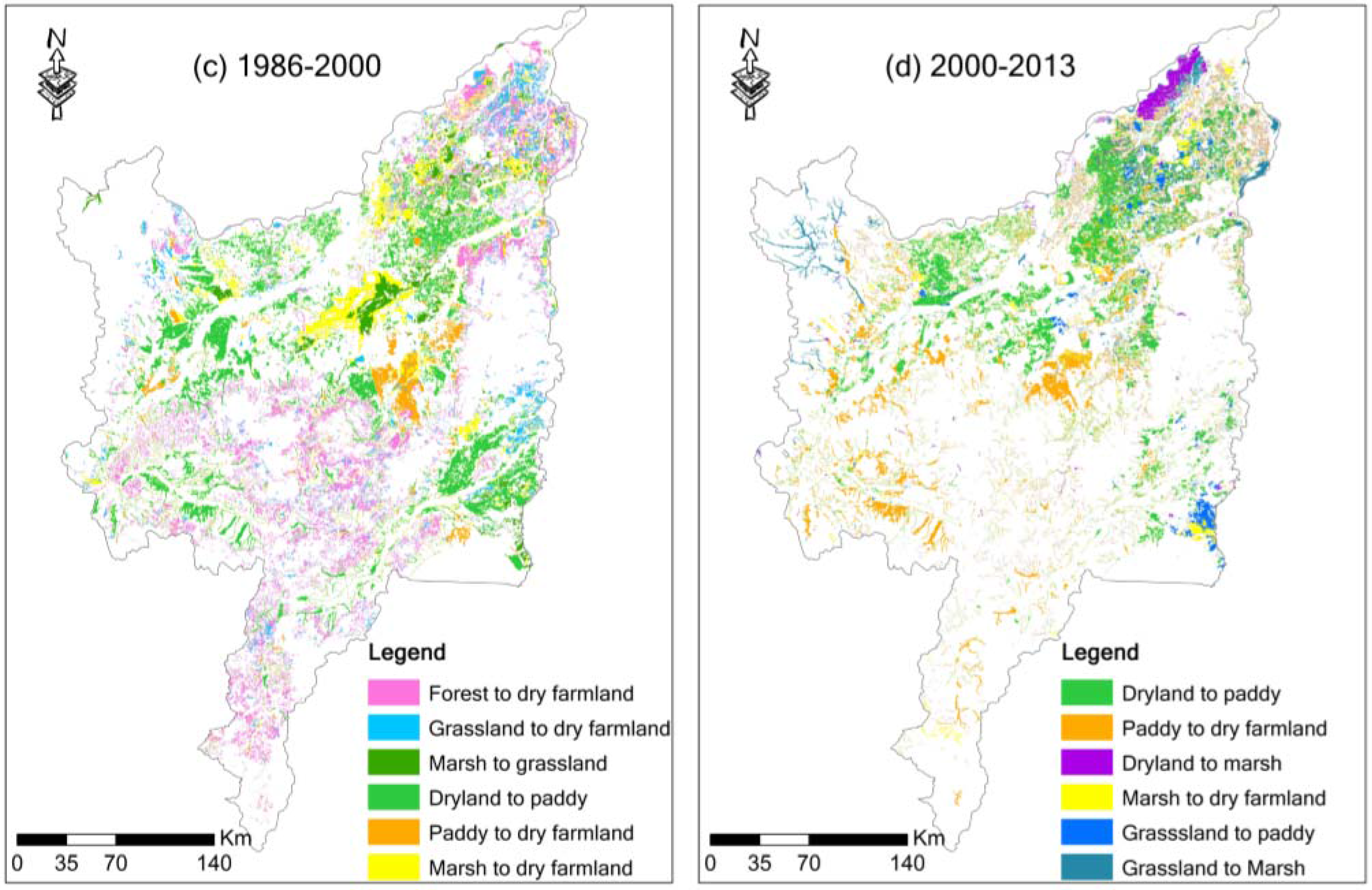
56] found that paddy and dry farmland had different change processes by analyzing social statistics data and Liu et al. [
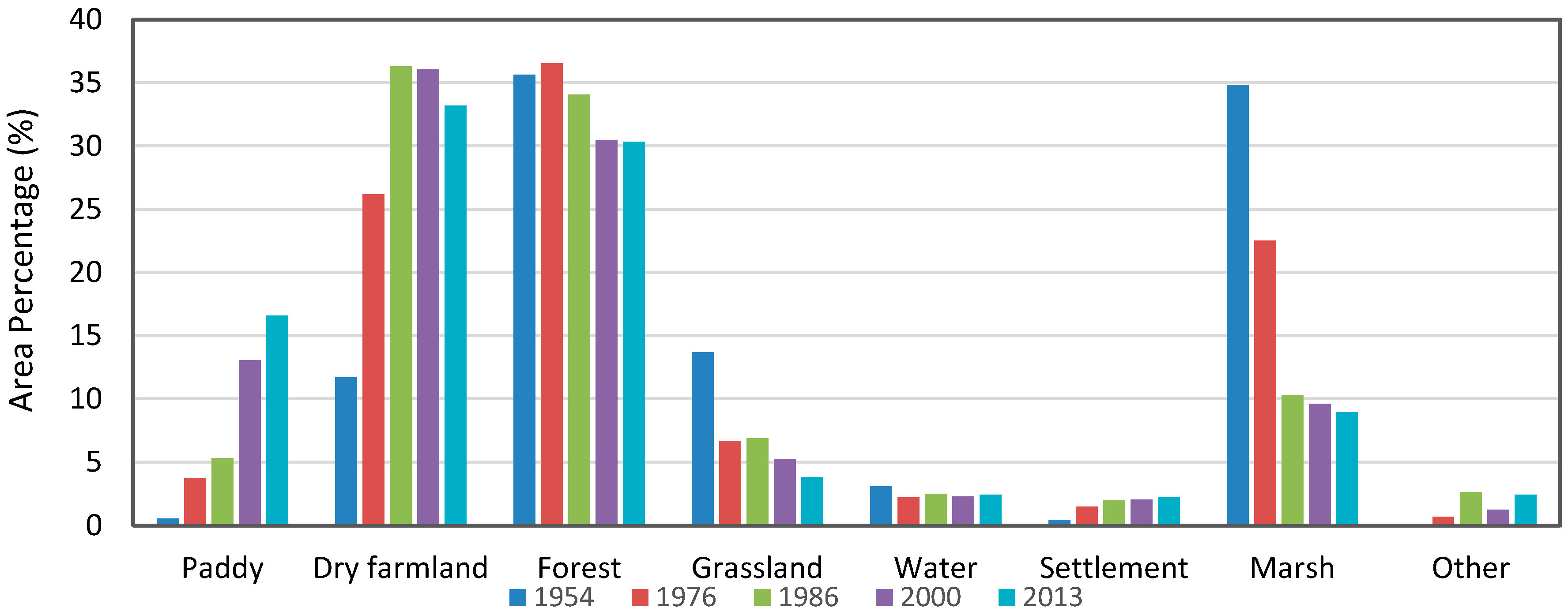
64] found that paddy and dry farmland were frequently changed to other LULC types in northeast China. However, important characteristics of LULCC between paddy, dry farmland and other LULC types remain uncertain, especially the spatial pattern of these changes. Also, separating dry farmland from paddy is needed to estimate the values and structure of ecosystem services in this region. The objectives of this study include: (1) to analyze the spatiotemporal changes and changes in spatial structure of land degradation in the study area; (2) to estimate the role of human activities on land degradation in Sanjiang Plain quantitatively; and (3) to discuss the effects of land degradation on ESV change in the study area in order to provide scientific information to inform sustainable use of land resources.
4. Discussion
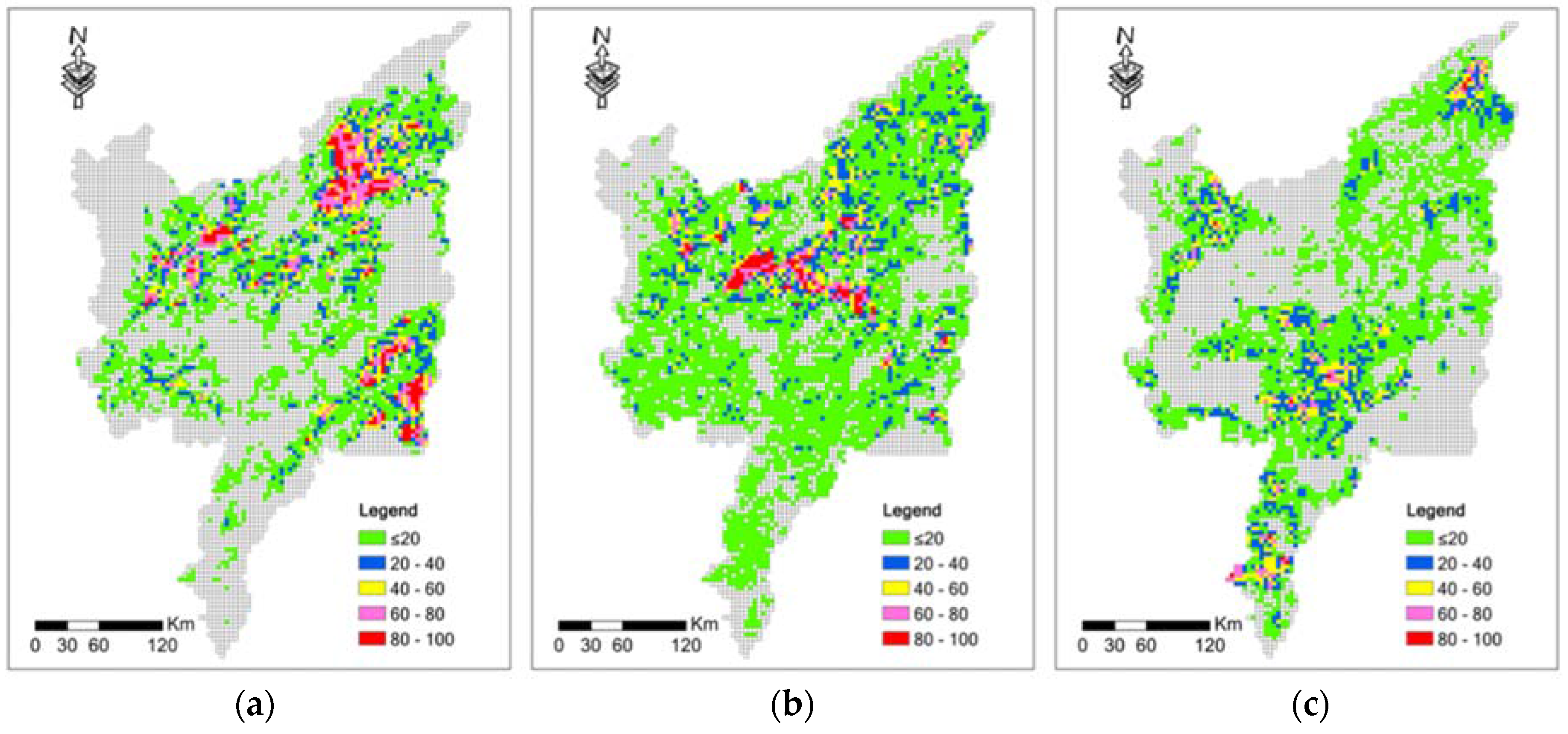
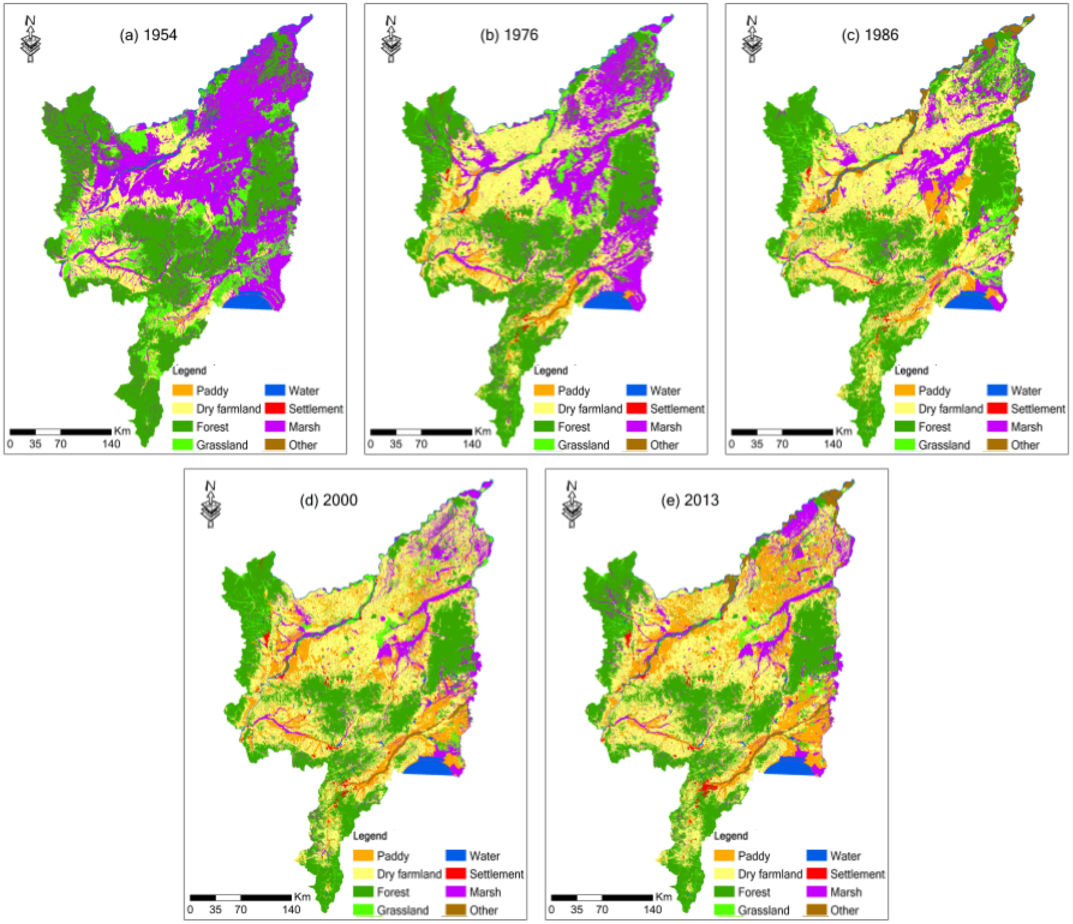
Our study shows that integrating multi sources of data, including topographic maps, Landsat MSS/TM/OLI images, vegetation map, and soil maps etc., is a useful and economically feasible way to reconstruct historical LULCC maps and estimate changes in ESV at the regional level. In many cases, satellites data may be the most inexpensive way to gather information for historical LULC maps with high spatial, spectral resolution. One problem in estimating the accuracy of LULC classification is the lack of historical LULC data [
9]. In this study, extensive field surveys were performed in the year 2000 and the year 2013 to ensure the accuracy of our maps. Meanwhile, historical records including aerial photos, tabular data in a large number of field sites and statistic data of Heilongjiang Province were used to estimate the interpretation results. Additionally, we interviewed many local people as well as experts to test the interpretation accuracy. In order to reduce error caused by post classification, the outline of LULCC is delimited by comparison of Landsat data in different periods. For example, the outline of LULC in 2000 is delimited by comparison of TM data in 1986 and 2000, with the references from land-use background in 1986. Even though they contain some uncertainties, the classification system and LULC maps reported by this study are credible.
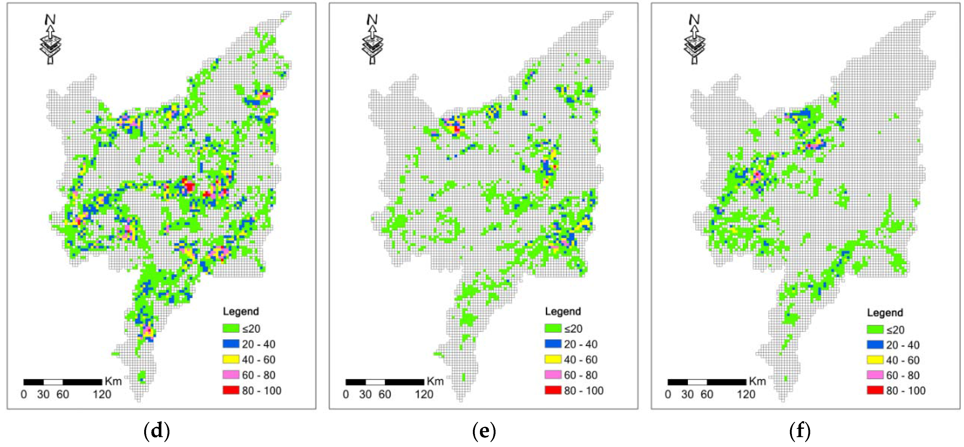
Human activities play a significant role in land degradation [
56,
57,
58], and land degradation is particularly related to increases in population and intensive agriculture [
64]. Our study showed that human activities (89.67%) were the dominant factors responsible for land degradation in the study area. In Sanjiang Plain, the population increased from 1.40 million in the 1950s to 9.74 million in the 2010s [
56,
62], which accounts for the growth of farmland and settlement area. Several other studies have also shown that population growth is an important factor in LULC. Government policies also had a substantial effect on the observed spatiotemporal changes in land degradation. In Sanjiang Plain, the “Great Leap Forward” movement [
30,
74] in the 1950s promoted the immigration of about 81,500 veterans to reclaim wetlands for farmland to produce more food [
58]. Promoted by the “Going to the Countryside and Settling in the Communes” policy, approximately 450,000 educated youth moved to Sanjiang Plain and participated in agricultural activities in the early 1970s [
9,
58]. From 1978 to 1985, advanced agricultural machinery was introduced by the “Agricultural Modernization” [
62] policy, promoting large-scale reclamation. From 1992 to 1995, the policy of “to promote conversion from dry farmland to paddy” in northeast China promoted conversion of dry farmland to paddy [
75,
76]. In the late 1990s, as the great ecological value of wetlands was recognized, the government began to take action to protect wetlands and some policies such as “returning farmland to wetland” were published [
75,
77,
78] Additional, some policies such as "returning farmland to forestland", and "returning farmland to grassland" were put into place. All these policies affected the LULCC pattern in this region. The dramatic land degradation and the changes of land use structure that have taken place in this region will affect the water cycle, carbon balance and other biogeochemical processes. Future studies should investigate these questions.
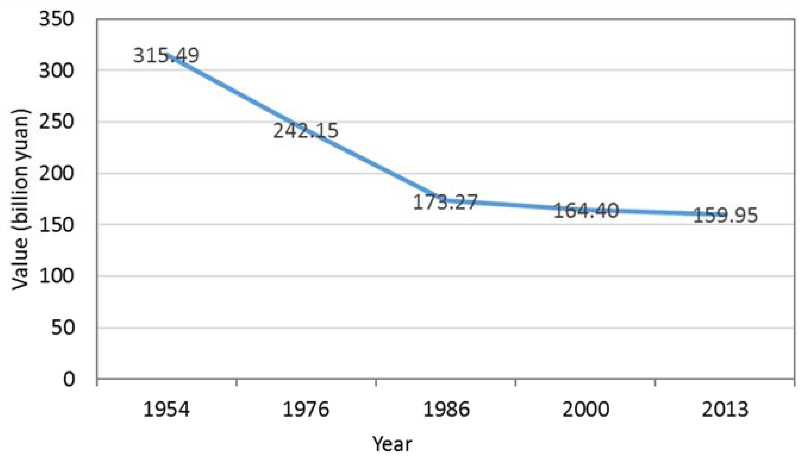
The ESV estimation method used in this study was developed by Costanza et al. [
31] and Xie et al. [
47,
48], and has been significant in estimating changes in ESV in response to human disturbance [
34,
79]. Based on NPP, we modified the value coefficients for the study area. The method used in this study was just one of many methods used to calculate ESV and the results are subject to some uncertainties such as limitations of economic valuation [
31] and the possibility of double-counting [
80,
81]. As discussed in the Introduction, there are important differences between the ESV of paddy field and dry farmland. The trends in total ESV that we obtained were consistent with those from previous studies. However, our study captured a smaller ESV change between the 1980s and 2000s than previous studies. This result occurred mainly because we separated paddy and dry farmland in our study of ESV, whereas previous studies grouped paddy and dry farmland together as cropland. As a result, we captured ESV changes caused by the large changes in area from dry farmland to paddy during this period. We estimated the coefficients of these land use types using NPP and the coefficient cropland, which may include some degree of uncertainty. In the future, more accurate value coefficients for paddy and dry farmland are needed to produce better estimates of ESV. However, by estimating and comparing the ESV in different time periods in our study, uncertainties could be reduced or offset [
34]. Additionally, our sensitivity analysis in our study indicated that our results are robust, despite these uncertainties.
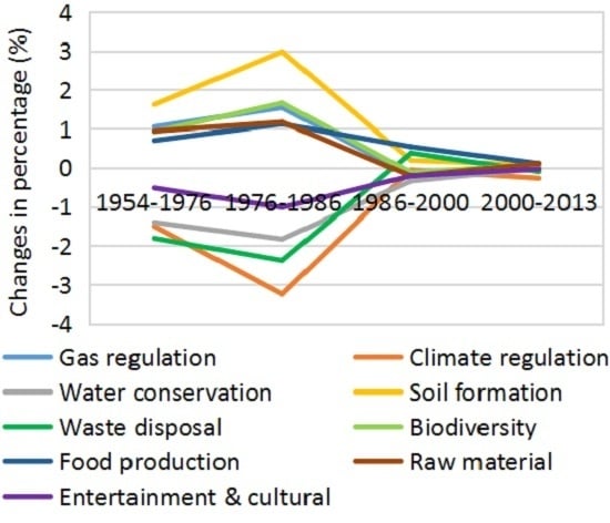
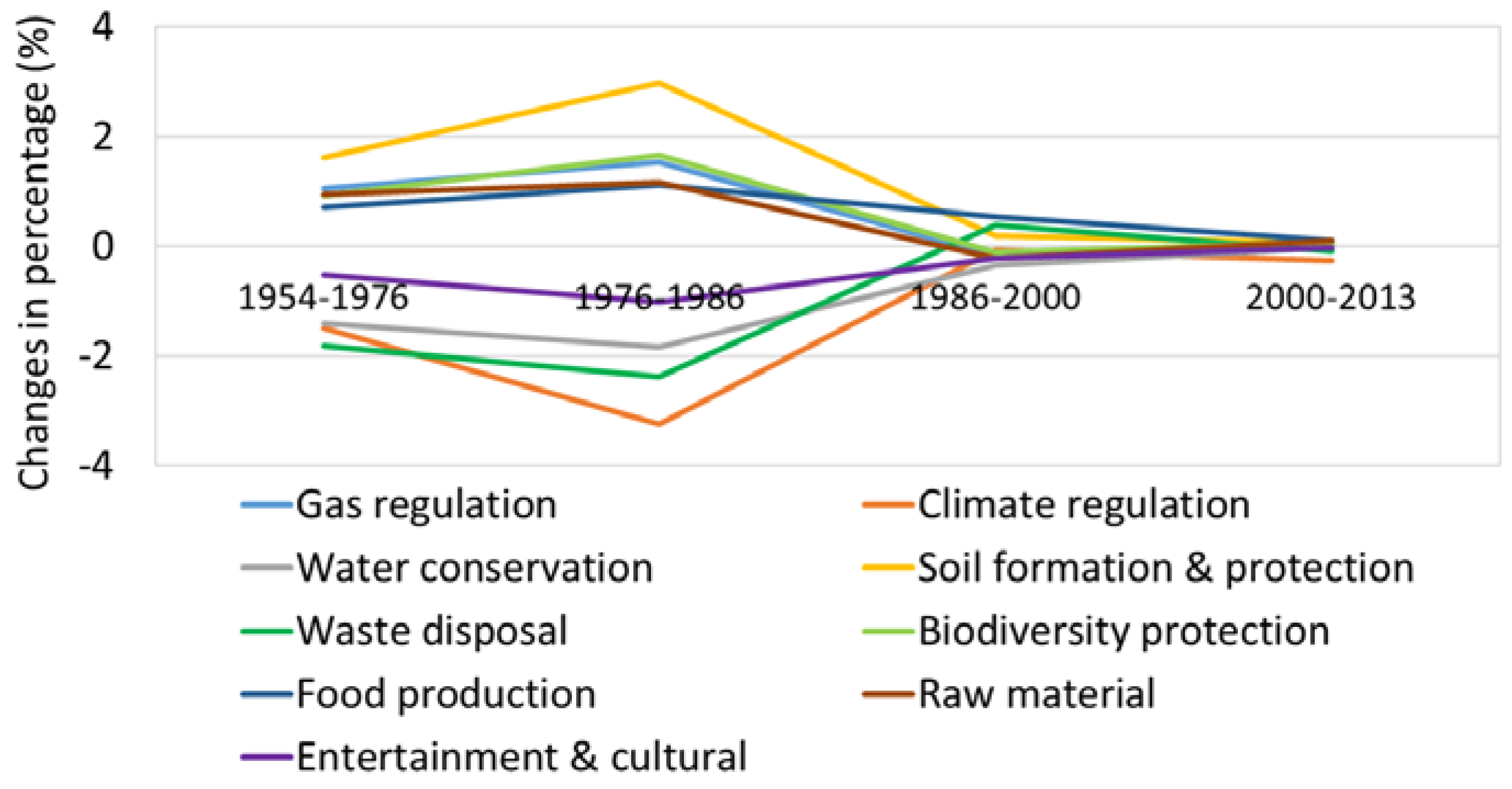
Despite some shortcomings, ESV has the potential to provide policy-makers with scientifically sound information in order to achieve sustainable development. For example, C. Estoque et al. offered important insights for achieving more successful urban planning in an analysis of landscape and ESV change in Baguio City [
51]. Based on analysis of ESV change in Chongming Island, Zhao et al. suggested that conservation of the wetlands and tidal flats should take precedence over the single-minded, uncontrolled reclamation of these areas for economic purposes in the future land use policies [
23]. In this study, we found that the ESV decline caused by marsh and forest degradation decreased during 2000–2013 while the decline caused by grassland degradation was still severe. This result occurred mainly because the policies such as “returning farmland to wetlands”, ”returning farmland to wetland” and establishing reserves for wetlands in China limited the degradation of wetlands and forest to some extent. Therefore, the policy-makers should pay attention to changing other LULC types to grassland in addition to the protection of current grassland.


 ,
, 


