Review

Multi-Temporal InSAR and Machine Learning for Geohazard Monitoring: A Systematic Review with Emphasis on Noise Mitigation and Model Transferability

by
Alex Alonso-Díaz
1,*,
Miguel Fontes
2,3,
Ana Cláudia Teixeira
2,3,
Shimon Wdowinski
4 and
Joaquim J. Sousa
2,3
1
The Spanish Naval Academy, Defense University Center, Plaza de España, s/n, 36920 Marín, Spain
2
Institute for Systems and Computer Engineering, Technology and Science, Porto, Portugal
3
Engineering Department, School of Science and Technology, University of Trás-os-Montes e Alto Douro, 5000-801 Vila Real, Portugal
4
Institute of Environment, Department of Earth and Environment, Florida International University, Miami, FL 33199, USA
*
Author to whom correspondence should be addressed.
Remote Sens. 2026, 18(9), 1356; https://doi.org/10.3390/rs18091356
Submission received: 24 February 2026 / Revised: 10 April 2026 / Accepted: 21 April 2026 / Published: 28 April 2026

Highlights

What are the main findings?
  • Deep Learning architectures, particularly CNNs and U-Nets, significantly outperform traditional pixel-based methods in identifying complex geomorphological signatures and automating landslide inventory updates.
  • Hybrid models combining Multi-Temporal InSAR with LSTM and Transformer networks enable the transition from static velocity mapping to non-linear displacement forecasting with high temporal precision.
What are the implications of the main findings?
  • The integration of Physics-Informed Neural Networks (PINNs) provides a robust framework for disentangling atmospheric noise from true ground deformation, enhancing the reliability of early warning systems.
  • Addressing model transferability and explainability (XAI) is essential for the transition from academic experimentation to trustworthy, operational geohazard monitoring across diverse geographic and sensor domains.

Abstract

Interferometric Synthetic Aperture Radar (InSAR) enables regional monitoring of ground deformation, but operational geohazard analysis remains challenged by atmospheric artefacts, temporal decorrelation, and the need for scalable interpretation of multi-temporal products. A systematic review was conducted through searches in Scopus and Web of Science, resulting in 135 peer-reviewed scientific articles on the integration of Machine Learning (ML) and Deep Learning (DL) with multi-temporal InSAR (MT-InSAR). The literature is dominated by applications to landslides and land subsidence, with additional studies addressing volcanic unrest and other deformation-related hazards. Persistent Scatterer (PS) and Small-Baseline Subset (SBAS) approaches are frequently used to derive deformation time series, which are then coupled with ML/DL for the detection and mapping of active phenomena and for short-horizon forecasting. Convolutional architectures, such as Convolutional Neural Networks (CNNs), are commonly reported for spatial recognition tasks, while recurrent models like Long Short-Term Memory (LSTM) networks are often applied to time-series prediction. Reported benefits include improved automation and predictive performance, although sensitivity to noise sources remains a challenge. Overall, the evidence supports AI-enabled InSAR workflows for scalable geohazard monitoring, while highlighting the need for standardized benchmarks and systematic transferability assessment. This review provides a roadmap for transitioning from research prototypes to operational early-warning systems.

1. Introduction

Monitoring surface deformation is central to geohazard assessment because ground displacement frequently precedes damaging events and affects exposed people, infrastructure, and economic activity [1,2,3]. Remote sensing has become a core component of geohazard monitoring strategies, providing spatially extensive observations that complement field instrumentation and support detection, characterization, and early warning, particularly for landslides and other slope instabilities [1,2]. Within this context, Interferometric Synthetic Aperture Radar (InSAR) has become a leading technique for measuring deformation with high spatial coverage and centimeter-to-millimeter sensitivity under day and night conditions and with limited dependence on cloud cover [4,5].
Foundational developments in SAR interferometry established the theoretical and processing basis for deformation retrieval [4,5]. Subsequent advances from differential InSAR to multi-temporal InSAR (MT-InSAR) enabled robust time series reconstruction by exploiting stable radar targets and redundant interferogram networks. Persistent Scatterer Interferometry (PS-InSAR) demonstrated the value of long-term monitoring from coherent scatterers for urban and semi-urban environments [6], while Small Baseline Subset (SBAS) approaches improved performance in areas affected by decorrelation by limiting temporal and spatial baselines and by leveraging network solutions [7]. These methodological developments increased the feasibility of systematic deformation mapping and created the basis for large-scale services.
The availability of dense satellite archives, especially from operational constellations such as Sentinel-1, has increased both opportunity and pressure for automation. Sentinel-1’s systematic acquisition strategy and frequent revisits support continuous monitoring, but also produce data volumes that challenge expert-driven processing and interpretation workflows [8]. The systematic acquisition strategy of Sentinel-1 results in daily data volumes of several terabytes, making traditional manual inspection impractical for large-scale monitoring.
At the same time, InSAR measurements remain vulnerable to error sources that can mask, distort, or mimic deformation signals. Temporal decorrelation limits coherence over vegetated and rapidly changing surfaces [9], and atmospheric phase delays can introduce spatially correlated artifacts that degrade the reliability of deformation estimates if not modeled or mitigated [10]. These constraints remain critical for geohazards that exhibit subtle precursory motion and for applications requiring operational decision support.
Machine learning (ML) and deep learning (DL) offer a pathway to scale InSAR exploitation by automating recognition, segmentation, and forecasting tasks that were traditionally manual or semi-manual. ML has a long track record in geoscience and remote sensing for pattern recognition and nonlinear prediction [11], while DL has shifted the paradigm from manual feature engineering, where practitioners pre-define statistical thresholds for coherence or displacement, to automated end-to-end representation learning. This allows for the extraction of hierarchical features directly from raw interferometric phase or complex time-series, which is particularly effective for filtering non-linear noise sources, such as atmospheric phase screens (APS), that often evade traditional ML algorithms [12,13]. In remote sensing, convolutional architectures support robust spatial feature extraction, while recurrent and attention-based architectures support temporal modeling at scale [13]. In the specific context of InSAR-derived products, DL-based instance segmentation has been used to delineate active landslide signatures from interferometric outputs in complex terrain [14]. Unsupervised and self-supervised strategies have also been explored to detect anomalous building displacement patterns from PS-InSAR time series, which is relevant for infrastructure monitoring and urban risk screening [15]. For forecasting, deep sequence models have evolved from traditional recurrent architectures to Transformers, which leverage self-attention mechanisms to capture long-range temporal dependencies and complex spatial correlations more effectively [16,17]. In parallel, the emergence of Physics-Informed Neural Networks (PINNs) represents a significant shift toward hybrid modeling; by embedding geomechanical constraints and physical laws directly into the loss function, PINNs aim to mitigate the impact of InSAR noise and ensure that deformation forecasts remain physically consistent, even in data-sparse environments.
Despite rapid growth, major barriers remain for operational deployment. Evidence across recent applications indicates that model performance can degrade under domain shifts, including changes in lithology, land cover, deformation regimes, sensor characteristics, and processing conventions, with limited availability of standardized benchmarks for cross-study comparison [18,19,20]. These limitations are relevant not only for landslides and subsidence but also for volcanic unrest detection, where false positives and missed detections carry high societal costs [21]. In addition, the interpretability of AI-assisted outputs is increasingly recognized as necessary for trustworthy decision support, particularly when models are used to justify alerts and resource allocation [22].
This systematic review synthesizes 135 peer-reviewed journal articles retrieved from Scopus and Web of Science to assess the state of integration between MT-InSAR processing and ML/DL methods for geohazard monitoring. To guide this synthesis, the paper addresses the following central research question: How have recent developments in deep learning architectures, including emerging physics-informed models such as PINNs and more established Transformer-based approaches, contributed to mitigating dominant InSAR noise sources while maintaining geomechanical interpretability? Furthermore, to what extent can these models be transferred between heterogeneous geohazard scenarios (from regional-scale subsidence to site-specific landslides) without substantial loss of accuracy or the need for extensive retraining? By addressing these questions, emphasis is placed on (i) how AI is being used to suppress or bypass dominant noise sources such as atmospheric artifacts and decorrelation, (ii) the extent to which published models demonstrate transferability across regions and sensors, and (iii) methodological and data gaps that limit reproducibility, benchmarking, and adoption in risk management workflows. The remainder of the paper organizes evidence by AI task type (detection, segmentation, classification, and forecasting), discusses validation practices and datasets, and outlines priorities for developing robust and interpretable AI-InSAR pipelines for operational geohazard services.
Furthermore, as AI-enabled InSAR transitions from experimental research to operational geohazard monitoring, the “black-box” nature of DL architectures poses a significant challenge. The inherent complexity of InSAR, where signals are frequently masked by geodetic noise, such as APS and temporal decorrelation [7,10], demands more than just high predictive accuracy. It requires a transparent understanding of how models distinguish between true ground deformation and phase artifacts. Therefore, the integration of Explainable AI (XAI) and robust uncertainty quantification emerges not only as a technical refinement but as a fundamental requirement for building trust with decision-makers [12,22]. This nexus between noise sensitivity and model interpretability is a core theme of this review, setting the stage for a critical discussion on the operational readiness and future reliability of these systems.

2. Materials and Methods

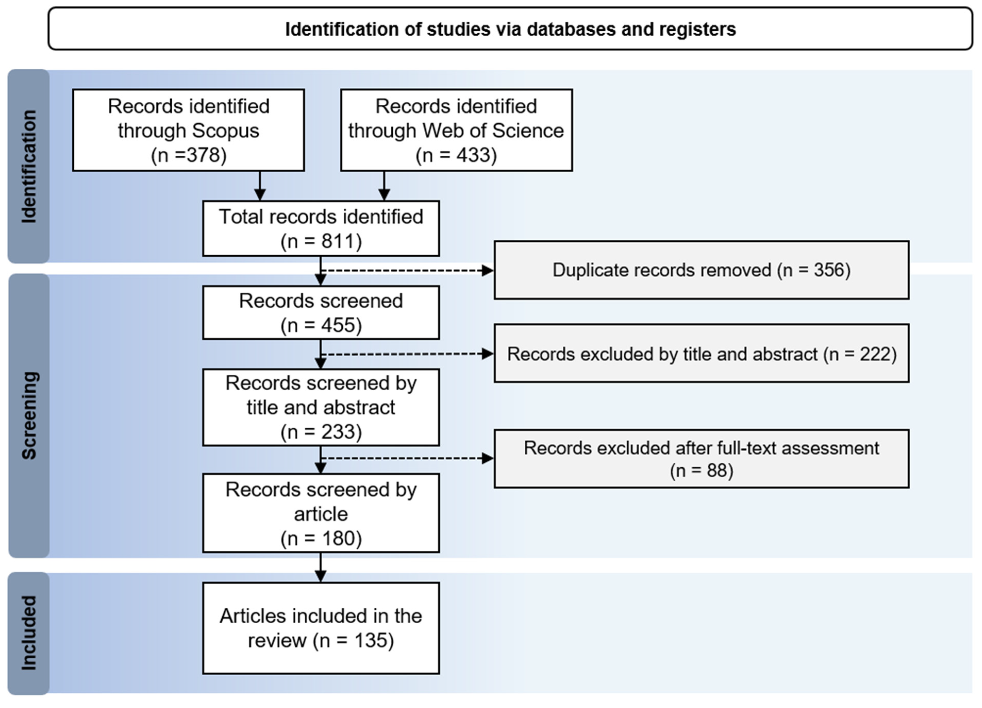
A systematic review was conducted to synthesize evidence on the integration of ML and DL with MT-InSAR for geohazard monitoring, following the PRISMA 2020 guidelines (PRISMA 2020 Checklist in Table S1) [23,24]. Records were retrieved from Scopus and Web of Science, deduplicated, and screened through successive stages of title, abstract, and full-text assessment. As illustrated in the PRISMA flow diagram (Figure 1), although the initial database search retrieved 811 records, the majority did not meet the methodological scope of this review. Many were conference papers, non-peer-reviewed documents or studies that used SAR backscatter without interferometric deformation products. Additional exclusions resulted from works in which ML or DL was limited to basic statistical fitting or where no geohazard-related deformation analysis was performed. After removing duplicates and applying these predefined PRISMA-compliant criteria, only 135 studies remained that combined MT InSAR with a substantive ML or DL methodological component. The final number is therefore a reflection of strict eligibility boundaries rather than search incompleteness.
The technical ecosystem of these studies (Table 1) highlights a dominance of open-source AI frameworks, reflecting a community shift toward DL architectures that utilize GPU acceleration and high-performance computing (HPC).
Analysis of this ecosystem reveals a significant methodological shift after 2022. While early DL applications frequently used TensorFlow and Keras, there is a clear migration toward PyTorch. This trend is driven by the requirements of complex, non-linear architectures, such as Graph Neural Networks (GNNs) for irregular InSAR point clouds and ViT. PyTorch’s dynamic computational graph and support for geometric DL facilitate the implementation of PINNs, which integrate geomechanical priors through custom loss functions.

2.1. Information Sources and Search Strategy

Scopus and Web of Science Core Collection were searched in January 2026 for peer-reviewed articles addressing the integration of InSAR-based deformation data with ML or DL for geohazard monitoring. The search strategy was structured around three concept blocks: (i) InSAR and MT-InSAR terminology (e.g., PS-InSAR, SBAS), (ii) ML and DL terminology (e.g., CNN, LSTM, Transformers, PINNs), and (iii) geohazard and deformation monitoring tasks (e.g., detection, forecasting).
To ensure methodological comparability, results were restricted to English-language journal articles. All included works were peer-reviewed journal articles, including studies published online early or marked as in press that had already undergone full peer review and were assigned to forthcoming publication years. No preprints or non-peer-reviewed sources were included. The inclusion of terms such as “anomaly detection” and “forecasting” reflects the bibliometric shift from static susceptibility mapping to dynamic, operational research.
To ensure full reproducibility, the exact search strings used in each database are now provided. For Scopus, the search query was: TITLE ABS KEY (“InSAR” OR “Interferometric Synthetic Aperture Radar” OR “PS InSAR” OR “SBAS”) AND TITLE ABS KEY (“machine learning” OR “deep learning” OR “CNN” OR “LSTM” OR “Transformer” OR “PINN”) AND TITLE ABS KEY (“landslide” OR “subsidence” OR “ground deformation” OR “geohazard”). For Web of Science Core Collection, the search string was: TS = ((“InSAR” OR “PS InSAR” OR “SBAS”) AND (“machine learning” OR “deep learning” OR “CNN” OR “LSTM” OR “Transformer” OR “PINN”) AND (“landslide” OR “subsidence” OR “ground deformation” OR “geohazard”)). The complete list of all query variants, including the exact filters applied, is provided in Tables S2 and S3 to enable full replication of the search procedure.
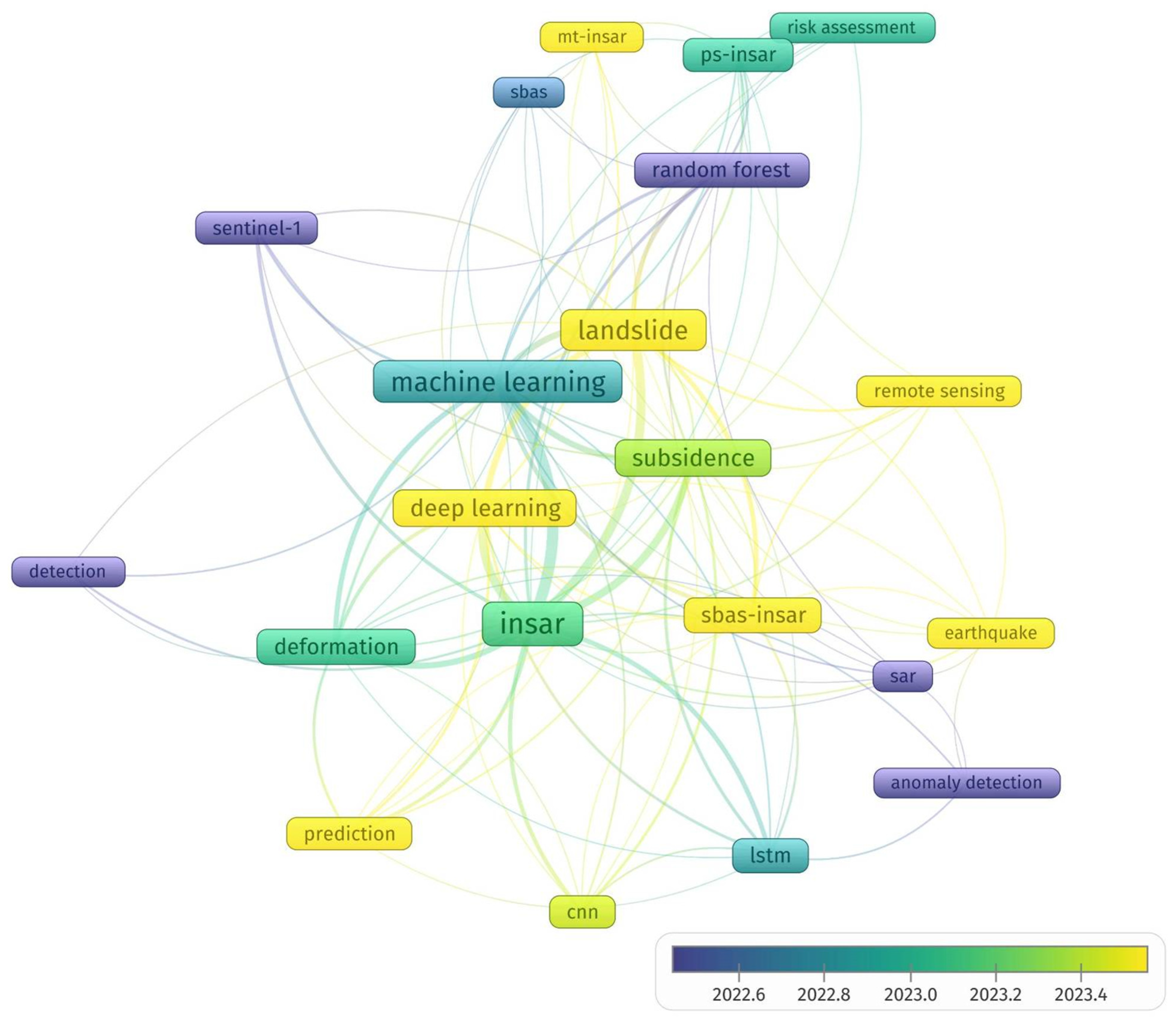
The keyword co-occurrence network (Figure 2) illustrates a thematic and temporal migration. Node colors indicate a transition from classical ML focused on static landslide susceptibility (cooler tones) to the recent dominance of DL, CNN, and LSTM architectures (warmer tones). The strong connectivity between “PS-InSAR” and “Time-series prediction” underscores the shift toward automated monitoring. Emerging clusters for “Transformers” and “Anomaly Detection” highlight the field’s current frontier: processing massive Sentinel-1 data volumes for operational early-warning systems.
To substantiate this thematic and temporal migration beyond visual inspection, we conducted a quantitative bibliometric analysis. Specifically, we computed: (i) the annual frequency of the 25 most recurrent keywords in the corpus (2015–2025), (ii) keyword burstness using Kleinberg’s algorithm, identifying statistically significant periods of thematic emergence, and (iii) the temporal centroid of each keyword cluster.
These indicators confirm the trends suggested in Figure 2. Core terms such as ‘InSAR’ (81 occurrences), ‘machine learning’ (56 occurrences), and ‘landslide’ (48 occurrences) dominate the network, highlighting their central role in the literature. Classical machine learning approaches, particularly “Random Forest” (14 occurrences), were more prominent in earlier years. Conversely, deep learning (DL)-related terms such as “deep learning” (31 occurrences), “CNN” (10 occurrences), and “LSTM” (14 occurrences) have increased markedly since 2021. InSAR-specific techniques such as “SBAS-InSAR” (19 occurrences) and “PS-InSAR” (11 occurrences), together with application-driven terms such as “subsidence” (31 occurrences) and “deformation” (20 occurrences), suggest a shift towards more sophisticated monitoring and application-focused research. Recent bursts for “Transformer” (2023–2025) and “PINNs” (2024–2025) further validate the emergence of new research frontiers. Detailed results are provided in Supplementary Table S4.

2.2. Eligibility Criteria

To ensure a high-quality and homogeneous corpus, eligibility criteria were defined a priori following the PRISMA 2020 guidelines [23,24]. The selection process, summarized in Table 2, prioritized peer-reviewed journal articles providing methodological transparency in both InSAR processing and AI architectures. Studies were excluded if the ML/DL component was limited to basic statistical fitting or if the radar data did not involve interferometric deformation retrieval (e.g., backscatter-only analysis). This filtering ensures that the 135 synthesized articles represent substantive advancements in automated geohazard detection, mapping, and forecasting.

2.3. Screening and Study Selection

The screening process was conducted in two stages to ensure the relevance of the evidence base. Initially, titles and abstracts were evaluated to remove records not addressing geohazards, InSAR-derived deformation, or ML/DL applications. Special attention was given to the integration strength between InSAR and AI, prioritizing studies where architectures were tuned to handle SAR-specific properties (e.g., Rician noise or irregular temporal sampling).
Full texts were subsequently assessed against the criteria in Table 2. An additional scope-alignment step excluded studies where (i) SAR analysis lacked interferometric deformation products (e.g., backscatter-only), (ii) AI was limited to basic statistical fitting, or (iii) InSAR data were not a core input or outcome. This rigorous refinement resulted in a final set of 135 studies, as detailed in the PRISMA 2020 flow diagram (Figure 1), ensuring a consistent focus on AI-enabled geohazard analysis.

2.4. Data Extraction and Coding

Data from the included studies (n = 135) were extracted using a structured form to support descriptive mapping and cross-study comparison. The extracted fields were categorized into four thematic blocks: (i) bibliographic metadata and geohazard focus; (ii) MT-InSAR characteristics, including processing algorithms (PS-InSAR, SBAS) and deformation products; (iii) AI implementation, covering model architectures (CNN, LSTM, Transformers, PINNs), frameworks, and integration goals; and (iv) evaluation metrics, focusing on validation strategies, transferability, and operational relevance.
To ensure traceability, extracted information was linked to supporting evidence from the original articles, with unreported fields coded as “not reported” to avoid inference. This coded dataset forms the basis for the taxonomies and synthesis presented in Section 3, Section 4 and Section 5.
Due to the high methodological heterogeneity across the included studies, quantitative meta-analysis was not feasible. The reviewed works differ substantially in geohazard type, input representations, MT InSAR processing choices, model architectures, reference data quality, and evaluation metrics, preventing the computation of standardised effect sizes. The synthesis, therefore, follows a qualitative comparative approach consistent with PRISMA recommendations for cases where statistical aggregation is not methodologically appropriate.

2.5. Evidence Synthesis and Analysis

The synthesis was structured around two primary dimensions: (i) the learning objective and model family, ranging from spatial segmentation (CNN, U-Net) to temporal modeling (Transformers, recurrent models); and (ii) the geohazard domain, including landslides, subsidence, volcanic unrest, and seismic deformation. This dual organization facilitates comparing methodological requirements, such as the distinct temporal resolutions needed for volcanic versus subsidence monitoring.
Cross-cutting themes were synthesized to address four critical areas: (a) noise handling through hybrid architectures and PINNs; (b) ground truth quality and the integration of exogenous data (e.g., GNSS, groundwater levels); (c) validation rigor and the use of XAI; and (d) model transferability across different sensors and geological settings.
Findings are reported using consistent terminology and comparable performance measures where available. Gaps in benchmarking, reproducibility, and operational readiness were identified by assessing code and data availability, directly informing the recommendations in Section 5 and the concluding remarks in Section 6.

3. Overview and Classification of the Literature

The evidence base comprises 180 references, with 135 core empirical studies focusing on the intersection of InSAR-derived deformation and AI. While early research was constrained by data availability, the Sentinel-1 mission’s open-access policy transitioned the field from small-scale feasibility tests to high-revisit, big data analytics.

3.1. Trends in Data Representation and Architecture

A primary distinction in the literature emerges from the representation of InSAR products for learning, divided into three methodological streams:
  • Spatial-Pattern Recognition (Image-based): These studies treat InSAR outputs (interferograms, coherence maps, or velocity fields) as 2D/3D tensors. While CNNs and U-Nets [25,38,39] remain standard for landslide and subsidence detection, recent work shows a transition toward ViTs and Attention-based models [17,40]. Architectures like Hybrid-SegUFormer [41] leverage self-attention to capture long-range spatial dependencies in complex fringes, overcoming the “local-view” limitations of traditional convolution kernels.
  • Focusing on displacement time-series, LSTMs and GRUs have dominated trajectory forecasting [26,42]. The 2024–2025 state-of-the-art emphasizes Bidirectional GRUs (Bi-GRUs) [31] and multi-component temporal models [43]. Increasingly, these models incorporate hydrological variables to ensure geomechanical consistency, as exemplified by the MUSEnet framework [44].
  • Graph-based and Advanced Geometrical Topologies: An emerging trend moves away from data “gridding” to maintain the original spatial topology of radar measurements. While traditional methods relied on interpolation, current research (2024–2025) focuses on Spacetimeformer networks [45] and Graph-based logic to process irregular MT-InSAR point clouds, avoiding artifacts introduced by gridding.
Across the reviewed corpus, framework adoption was unevenly distributed. A total of 72 studies used PyTorch, 41 relied on TensorFlow or Keras, 9 implemented custom or hybrid frameworks, and 13 did not report the framework used. These counts indicate a gradual shift toward PyTorch in publications from 2020 onward, although TensorFlow and Keras remain well represented in earlier studies.

3.2. Categorization by Geohazard and AI Task

The literature demonstrates that the choice of architecture is strictly coupled with the geohazard’s physical nature. Table 3 (below) classifies these trends.

3.3. Synthesis of Thematic Evolution

The thematic structure of the literature, further illustrated by the keyword co-occurrence network (Figure 2), reveals a maturing field. There is a clear shift from treating InSAR as a simple source of labels for classical ML models towards integrated frameworks where AI architectures are specifically tailored to the geometric and temporal properties of radar data. Notably, the rise in unsupervised anomaly detection, exemplified by the ALADDIn framework [29], and the adoption of Graph-based topologies [47] represent the current effort to bypass the chronic shortage of labeled training data in geohazard monitoring. These patterns underscore a move toward more autonomous, physics-aware monitoring systems, setting the stage for the critical synthesis of regional applications discussed in the following section.

4. AI Architectures and Methods for InSAR

The integration of AI into InSAR workflows marks a shift from deterministic signal processing toward data-driven inference. This evolution is driven by the need to manage the high dimensionality and non-linear noise, such as atmospheric phase screening (APS) and temporal decorrelation, inherent in modern SAR datasets. As the field advances toward operational early-warning systems, the focus is transitioning from black-box models to architectures that incorporate geomechanical constraints and provide explainable outputs.
The choice of AI architecture is dictated by the representation of the deformation signal. To facilitate analysis, the reviewed methods are categorized into four technical paradigms (Table 4), providing a baseline for discussing how spatial textures, temporal evolutions, and multi-source attributes transform interferometric phase into geohazard intelligence. Because several recent frameworks combine multiple methodological strategies (for example, ALADDIn integrates LSTM-based temporal modelling with unsupervised anomaly detection), the categories in Table 4 are not mutually exclusive. They represent dominant methodological foci rather than strict, single-label classes.

4.1. Spatial Feature Learning: Use of CNNs, U-Nets, and Attention Mechanismsfor Detecting Geomorphological Signatures

Spatial learning approaches treat InSAR and MT-InSAR outputs as structured images to recognize deformation morphologies. CNN-based models are widely used as their convolutional filters capture local spatial dependencies across scales, essential for identifying patterns ranging from sharp phase gradients to broad deformation bowls. When trained with labeled data, CNNs enable automated large-area screening, prioritizing candidate zones for detailed analysis.
For precise inventory mapping, encoder–decoder architectures like U-Net combine multi-scale context with high-resolution boundary reconstruction [25]. In InSAR, these are typically adapted for multi-channel inputs (e.g., phase-gradients, coherence, or deformation rates) to produce pixel-wise masks. Recent iterations combine U-Net decoding with transformer-based encoders and multi-scale fusion to improve robustness against decorrelation and atmospheric artifacts in complex terrains [41].
Instance segmentation models, such as Mask R-CNN, are preferred when targets are discrete and spatially bounded. These have been successfully applied to landslide recognition [14] and wide-area mining subsidence detection [53], where region-based learning outperforms simple pixel-wise classification. In urban settings, CNNs have shown feasibility in learning spatial cues even from sparse and irregular PS observations [39]. However, a more fundamental shift is the adoption of GNNs [47], which treat PS points as irregular nodes, bypassing gridding artifacts and preserving the original measurement topology.
The integration of XAI is transforming these models into transparent systems by verifying that they learn geomorphological features rather than processing artifacts [22]. Despite these advances, performance is sensitive to label quality and class imbalance. Robust evaluation designs using spatially independent testing remain critical to ensure that models do not inadvertently learn site-specific noise characteristics [54].

4.2. Temporal Feature Learning and Deformation Forecasting from InSAR Time Series

Reliable monitoring requires modeling the temporal evolution of displacement. MT-InSAR provides dense histories, but irregular sampling, seasonal components, and noise complicate forecasting. Temporal learning aims to predict future displacement, reconstruct high-frequency fields from sparse data, or identify instability signatures for early-warning systems.
LSTM models remain baseline sequence predictors for slope processes and mining subsidence [26,42]. However, forecast skill depends on input quality, as residual atmospheric artifacts or unwrapping errors can propagate into the learned dynamics [38]. To capture non-linear trends and periodic components, attention-based variants and hybrid strategies have been proposed. These include ICA-assisted LSTM for ground motion decomposition [55] and VMD-coupled recurrent predictors to stabilize learning under non-stationary signals [31,56].
Recently, Transformer-based architectures like the Spacetimeformer have been introduced to model long-context spatiotemporal dependencies, particularly in permafrost instabilities [45]. Data-fusion approaches also emerge, where DL frameworks integrate InSAR with hydrological data to track groundwater-modulated settings [44]. Other designs, such as ConvLSTM, explicitly couple spatial and temporal correlations when deformation fields exhibit coherent structures [19,53].
Despite progress, several limitations persist: (i) model generalization across different sensors or regions is rarely demonstrated; (ii) forecasting performance is sensitive to evaluation design, where aggregate metrics may overlook critical spatially clustered errors [57]; and (iii) the integration of PINNs is increasingly necessary to ensure forecasts adhere to geomechanical laws, especially regarding non-linear landslide acceleration [12] and groundwater-induced subsidence [42,49].

4.3. Feature-Based ML and Ensemble Models Using InSAR-Derived Predictors

Feature-based ML and ensemble models are preferred when training labels are scarce, interpretability is required, or the task is framed as susceptibility mapping. In these workflows, MT-InSAR products (velocities, temporal metrics, or anomalies) and ancillary geospatial layers are transformed into tabular predictors. InSAR serves either as a core predictor or as an independent validation layer to verify predicted hotspots [58,59].
In landslide research, hybrid pipelines use SBAS to identify unstable areas before ensemble learning integrates geomorphological and environmental factors [19,20]. For instance, SBAS-derived deformation has been coupled with PSO-RF to improve prediction in complex terrains [60]. Beyond static mapping, dynamic susceptibility frameworks now combine InSAR measurements with ML to reduce temporal mismatches in hazard assessment [27,61]. Hybrid schemes using multiple boosting learners, such as XGBoost and LightGBM, have also been applied after SBAS-based inventory updates to capture complex predictor-response relationships in corridor-scale assessments [62].
Feature-based approaches are similarly prevalent in subsidence and infrastructure monitoring. PS-InSAR measurements, combined with ML regressors, are used to map surface motion for road management [63]. At regional scales, RF models estimate the probability of deformation trend changes, supporting the screening of acceleration signals [64]. Local-scale studies integrate InSAR displacement with GNSS and ML to analyze settlement patterns in built environments and semiarid contexts [28,65].
Despite their advantages, these methods remain sensitive to inventory quality and spatial autocorrelation. The inclusion of XAI metrics, such as SHAP or feature importance rankings, is now standard practice to ensure deformation predictors are appropriately weighted relative to static factors [12]. Operational readiness requires transparent feature engineering, spatially aware validation, and robust uncertainty characterization aligned with risk-management needs.

4.4. Unsupervised Approaches for Large-Scale Anomaly Screening in InSAR

A major constraint in AI-enabled InSAR is the scarcity of reliable labels for regional or global monitoring. Unsupervised learning addresses this by separating background behavior from atypical patterns that may indicate transient deformation or artifacts. Dimensionality reduction and clustering, such as combining PCA with k-means, allow for the grouping of similar temporal signatures and the isolation of deviating clusters [66]. While efficient for wide-area processing, these methods are sensitive to the chosen dimensionality and the prevalence of atmospheric or seasonal signals.
Deep anomaly detection offers a complementary strategy by flagging departures from learned spatiotemporal structures. The ALADDIn framework, for instance, uses an autoencoder with an LSTM component to detect transient deformation in image time series without labeled examples, aiming to isolate deformation from atmospheric and orbital noise [29]. Related formulations support the automated identification of candidate areas for subsequent analysis [67].
Despite reducing label dependence, validating detected anomalies remains challenging, as false positives can arise from rare artifacts or shifting background conditions. Hybrid strategies using weak supervision can improve performance by transforming time series into high signal-to-noise representations, maintaining sensitivity to subtle motion [50]. Overall, unsupervised methods serve as the first stage in operational pipelines, prioritizing locations for targeted physics-based modeling or supervised classification.

4.5. Synthesis of AI Methodologies in InSAR Workflows

The technical landscape of AI–InSAR integration (Table 5) demonstrates a maturation of the field, evolving from experimental prototypes toward operational decision-support tools. The transition from early CNN-based classification to GNN [47] and spatiotemporal Transformers [45] reflects an increasing recognition of InSAR’s unique topological and temporal properties. Notably, combining GCN with LSTM layers has proven effective in capturing both the spatial connectivity of slope units and their temporal evolution [68]. While spatial paradigms (Section 4.1) have optimized the automated detection of geomorphological signatures in infrastructure and extreme environments [69], temporal models (Section 4.2) have advanced the prediction of non-linear deformation, especially when constrained by PIML [30] to ensure geomechanical consistency [12,49].
The parallel development of ensemble ML [49,70] for regional susceptibility and unsupervised anomaly screening [29] for wide-area monitoring addresses two critical bottlenecks: multi-source data fusion and the chronic shortage of labeled datasets. By leveraging XAI [22] and architectures like ALADDIn [29], the literature is converging toward a “human-in-the-loop” approach. In this framework, AI prioritizes candidate regions for expert verification, linking deformation patterns to high-impact triggers such as flash floods or groundwater shifts [71,72]. Despite these advancements, operational readiness remains challenged by domain shift and sensitivity to interferometric noise, underscoring the need for robust validation protocols and the deeper integration of physical laws into neural architectures.

5. Geohazard Detection: Applications and Performance

Across the included studies (n = 135), landslides and land subsidence constitute the dominant application domains, with 63 and 51 studies, respectively. Smaller categories include volcanic unrest (7 studies), infrastructure-related deformation (7 studies), and seismic deformation (6 studies).
These counts refer to application mentions rather than unique studies, because some works simultaneously address more than one geohazard type (e.g., combined landslide–subsidence analyses). The totals therefore do not necessarily sum to 135, whereas Table 3 reports the primary classification assigned to each study, resulting in a unique total of 135.

5.1. Landslide Identification and Susceptibility Mapping

Landslides represent the largest application domain, reflecting the suitability of MT-InSAR for capturing slow slope deformation. As summarized in Table 6, three primary objectives recur: spatial detection, susceptibility mapping, and kinematic forecasting.

5.1.1. Spatial Detection and Delineation

AI is used to automate the identification of deformation patterns consistent with slope processes. CNN-based segmentation and object detection, such as Mask R-CNN, recognize landslide signatures in complex terrain [14]. Unlike pixel-wise analysis, these models capture spatial continuity and geomechanical boundary signatures, helping to distinguish physical movement from isolated atmospheric noise. While effective for regional screening, performance remains sensitive to domain shift and label quality. Consequently, recent work has shifted toward GNNs [47] and ViTs [40] to learn topological representations less dependent on site-specific noise.

5.1.2. Susceptibility and Risk Mapping

Typically implemented through feature-based ensemble models, MT-InSAR serves as either a predictor or a validation layer. Ensemble learning (e.g., RF, XGBoost) combined with deformation evidence improves susceptibility zoning by discriminating between stable and active slopes [20,36]. Studies along high-exposure corridors demonstrate how PS-InSAR time-series strengthen the credibility of predicted susceptibility patterns [58,76]. Advanced dynamic susceptibility frameworks now update assessments in real-time, reducing the mismatch between static hazard zoning and evolving kinematics [27,88,92].

5.1.3. Forecasting and Kinematic Prediction

Temporal learning models project slope deformation for early-warning support. DL learning architectures (e.g., LSTM, GCN-LSTM) are physically justified by their ability to model the non-linear, acceleration-driven nature of slope failure [16,34]. These models act as numerical proxies for soil rheology, capturing creep and seasonal cycles that linear models overlook. However, forecast skills are often limited by residual noise and irregular sampling. Future progress relies on “foundation models” pre-trained on diverse SAR datasets to ensure consistent performance across varying climatic and geomorphic regimes [16,39,47].

5.2. Land Subsidence and Settlement

Land subsidence and infrastructure settlement represent the second-largest domain (n = 51), reflecting the high societal exposure of urban and industrial areas. Table 7 summarizes these applications, revealing a trend toward hybrid DL architectures for stability assessment.

5.2.1. Monitoring and Detection

AI automates the delineation of subsiding zones, prioritizing scalability for large-area screening [19,39]. Mask R-CNN architectures have been specifically deployed to detect mining-induced subsidence funnels [53,130], while ViTs are emerging to identify subtle volcanic or tectonic signals masked by noise [51]. Accuracy is further improved by combining InSAR metrics with multi-temporal coherence and simulated reflectivity maps [142].

5.2.2. Forecasting and Temporal Modeling

InSAR displacement time series are treated as sequences where temporal models (LSTM, GRU) are often combined with Variational Mode Decomposition (VMD) to handle non-stationary seasonal signals [43,56,138]. This shift toward recurrent architectures is physically justified as a numerical proxy for the visco-plastic behavior of soil and poroelastic lag [55,139]. Bio-inspired optimization (e.g., the Sparrow Search Algorithm) has also improved simulation accuracy for regional fracture patterns and land subsidence [143].

5.2.3. Susceptibility and Infrastructure Risk

Susceptibility is modeled by integrating deformation evidence with explanatory covariates like groundwater withdrawal and building density [113,121]. Ensemble models (RF, XGBoost) are preferred for their interpretability and feature importance metrics [49,70,144]. Recent frameworks like DBPFNet better integrate spatial and categorical drivers [116], particularly for metro and highway resilience assessments [63,118].

5.2.4. Validation and Transferability

Robust frameworks integrate independent geodetic data (GNSS or leveling) to quantify absolute accuracy [65,135]. However, model transferability remains a challenge due to “domain shift” between disparate geological contexts and urban densities. Emerging research into self-supervised pre-training and foundation models aims to establish a more generalized baseline for subsidence detection [52,120].

5.3. Volcanic and Seismic Hazards: Detection of Co-Seismic and Pre-Eruptive Signals

Volcanic and seismic monitoring requires detecting subtle signals and separating mixed sources under time-sensitive conditions. Table 8 summarizes these applications, highlighting a shift toward real-time processing and the mitigation of APS.

5.3.1. Volcanic Unrest and Pre-Eruptive Deformation

AI models excel at identifying the geometric symmetry of magmatic sources. While noise is often stochastic, unrest produces structured patterns (e.g., concentric fringes) consistent with crustal inflation. Architectures like ViT and Autoencoders isolate these components from confounding noise [29,51]. To overcome scarce reference data, researchers use physics-informed data augmentation, embedding analytical models (e.g., Mogi or Okada) into synthetic training pipelines to improve real-world reliability [153,155].

5.3.2. Seismic Mapping and Source Inversion

The dominant tasks include rapid estimation of coseismic displacement and fault parameter inference. DL facilitates “instantaneous” geodesy, approximating the elastic transfer function between fault slip and surface displacement much faster than traditional iterative inversion [19,146,148]. These models, trained on geomechanical simulations, honor the principles of continuum mechanics [149]. Emerging hybrid approaches now couple neural parameter estimation with uncertainty quantification to support trustworthy rapid-response decisions.

5.3.3. Transferability and Operational Screening

Transferability remains a hurdle as models often learn site-specific noise. Recent trends focus on unsupervised anomaly detection and ICA-assisted temporal learning to support monitoring at scale [29,55]. However, performance reporting remains heterogeneous, necessitating standardized benchmarking and physical consistency checks for deployment in early-warning contexts [150,154].

5.4. Other Applications in the Built Environment and Infrastructure Monitoring

Beyond geohazard mapping, AI-enabled InSAR is increasingly applied to asset-oriented monitoring and urban anomaly identification. These studies, summarized in Table 9, focus on rapid damage assessment and the structural stability of linear assets.

5.4.1. Building-Scale Anomalies and Urban Screening

Building-scale monitoring leverages the high density of PS in urban canyons. DL learning frameworks, such as the approach by Tripathi et al. [71], associate deformation patterns with high-impact triggers like flash floods. There is a shift toward graph-based architectures to model the structural connectivity of the urban fabric. By treating buildings as nodes, these models ensure that detected anomalies align with the mechanical stress distribution and differential settlement expected in masonry or concrete structures. Additionally, LSTM-Autoencoders (e.g., the ALADDIn framework [29]) are used to detect non-seasonal behaviors directly from PS time-series [15].

5.4.2. Infrastructure-Oriented Monitoring

AI enables the categorization of surface motion into specific engineering failure modes, such as thermal expansion in linear assets or embankment settlement [69,156]. Unsupervised screening using PCA and K-means is particularly valuable for processing massive monitoring archives where labels are scarce [66].
A significant advancement is the use of deep convolutional networks on wrapped interferograms [72]. This approach bypasses the error-prone phase unwrapping step, allowing for the identification of sharp hydromechanical boundaries. By learning signatures directly from phase fringes, models remain resilient to discontinuities caused by high soil moisture gradients, providing a direct link between InSAR observations and the geotechnical stability of infrastructure [72].

6. Discussion: Current Challenges and Future Perspectives

The evidence synthesized in this review indicates that ML and DL are fundamentally scaling InSAR-based monitoring. The field is transitioning from expert-driven, isolated case studies toward high-throughput workflows capable of processing massive SAR archives with systematic updates. This evolution is intrinsically linked to the proliferation of systematically acquired SAR time-series and the operational integration of Sentinel-1 data for wide-area deformation screening [8]. However, the evidence base underscores that reliable performance remains strictly conditioned by the error structure of InSAR products. APS, temporal decorrelation, and phase-unwrapping artifacts persist as dominant sources of uncertainty, impacting both the quality of the training signal and the validity of automated interpretations [9,10].
In this context, the current state of the field is characterized by selective maturity. Significant and repeatable gains are consistently reported for the automation of detection and mapping tasks in coherent, well-behaved settings. Conversely, broader operational readiness is hindered by limited model transferability, validation heterogeneity, and a lack of standardized benchmarking, challenges that reflect broader systemic issues in remote sensing DL [12,13].
Progress and limitations must therefore be interpreted jointly, emphasizing findings substantiated across diverse applications rather than isolated performance claims. While AI significantly accelerates data screening and pattern recognition, its capacity to autonomously decouple the true geodetic signal from complex, non-stationary noise remains the primary frontier for future research. Achieving this decoupling is essential for moving from mere anomaly detection to a robust, physics-consistent geohazard monitoring framework.

6.1. Consolidated Evidence Across Applications and Geohazard Tasks

Across the included studies, AI-enabled InSAR shows the most consistent and repeatable gains when the learning objective is well aligned with the physical information content of interferometric products and their dominant uncertainty sources. Rather than reiterating study-specific results already detailed in Table 6, Table 7, Table 8 and Table 9, the focus here is on synthesizing the broader patterns that emerge across hazard types and methodological families.
Spatial detection and delineation tasks represent the most mature and robust application domain. Across landslide, subsidence, mining and infrastructure contexts, results consistently demonstrate that CNN-based segmentation, detection-first strategies, and multi-scale hybrid architectures are particularly effective in transforming large InSAR archives into spatially explicit candidates for expert assessment [14,15,19,25,26,37,38,41,43,44,45,48,53,55,58,141,147]. These approaches benefit from the strong spatial structure of deformation fields and from the high density of coherent targets typically available in built or semi-urban environments. Collectively, the evidence suggests that current methodological strength lies not in replacing geodetic interpretation, but in accelerating and systematizing the conversion of complex interferometric information into operationally meaningful spatial intelligence.
Susceptibility and exposure-oriented mapping, despite being widely explored, exhibit more variable maturity. Their performance depends heavily on the consistency of conditioning factors, the quality of target labels, and the representativeness of training data across heterogeneous geomorphic settings. Ensemble learning and classical ML approaches remain prevalent [20,31,92,96], but the literature consistently shows that these pipelines are highly sensitive to spatial autocorrelation, label bias, and site-specific feature distributions. As a result, susceptibility mapping should be interpreted as context-dependent rather than universally transferable, especially where deformation signals are weak relative to the InSAR noise floor.
Time-series modelling and forecasting form a high-value but less mature category. Although several studies report promising results using recurrent, hybrid temporal, or attention-based architectures in landslide and subsidence monitoring [16,42,56,93,94,95,97,98], forecasting performance remains strongly conditioned by sampling gaps, seasonal components, and residual atmospheric artefacts. In seismic and volcanic contexts, the limited availability of labelled time-series and event diversity constrains the applicability of sequence-based modelling [116,131,135,136]. These patterns highlight that forecasting remains substantially more sensitive to sampling gaps, seasonal behaviour, and residual atmospheric artefacts than spatial mapping, reinforcing the need for rigorous, uncertainty-aware evaluation [9,10].
Finally, the observed differences in maturity across hazard domains reflect fundamental InSAR observability constraints. Stable-coherence environments such as urban subsidence settings facilitate robust model calibration [15,37,149], whereas settings dominated by rapid decoherence or seasonal variability, common in landslide-prone mountainous regions, limit generalization unless adverse conditions are explicitly represented during training [9,48,55]. Similarly, while volcanic and seismic applications are technically promising, their transferability remains structurally constrained by sparse training events and pronounced domain shift [21,43,49,55,57,130,134,137]. These differences reflect fundamental limitations in InSAR observability rather than inconsistencies in modelling strategy. Finally, the increasing integration of explainability and interpretable modelling [22,93] across these domains reflects a growing recognition that outputs must remain auditable, defensible, and decision-relevant, particularly where automated screening informs risk-management workflows.

6.2. Integration of AI Within MT-InSAR Processing Chains and Error Propagation

The reviewed literature demonstrates that AI can be integrated into MT-InSAR workflows at multiple stages, each with distinct implications for uncertainty propagation and operational readiness. Existing approaches fall broadly into three functional roles: archive-scale screening, spatial delineation, and temporal forecasting. To avoid duplication with Section 5, where detailed examples are provided, this section synthesises cross-study patterns and methodological consistencies rather than reiterating study-level results.
Archive-scale screening workflows, including detection-first segmentation, CNN-based classifiers, and unsupervised anomaly detectors, consistently reduce the manual burden associated with large interferometric datasets [14,25,26,29,38,41,43]. These models operate primarily on wrapped phase, coherence fields or deformation-rate summaries, and therefore remain sensitive to APS variability, residual atmospheric artefacts, and coherence gaps [9,10]. A recurring pattern across the literature is that screening-level models tend to learn the joint statistical structure of deformation signals and noise, reinforcing the need for explicit quality indicators when used at scale.
Spatial delineation and mapping convert MT-InSAR products into geospatially explicit layers that support inventory updating, susceptibility screening, or infrastructure monitoring. CNN-based segmentation, attention-augmented architectures, and graph-based methods routinely achieve high fidelity in coherent environments, where PS or DS coverage is dense [15,19,37,53,58,147]. Yet these approaches necessarily propagate upstream artefacts, decorrelation patterns, unwrapping inconsistencies, and terrain-dependent distortions into the feature space of the AI models [12]. As a result, spatial delineation workflows perform consistently only when measurement geometry, coherence regime, and ground-truth availability are well aligned, while generalisation across sensors, terrains, and acquisition settings remains limited.
Temporal modelling and forecasting represent the most ambitious but least mature integration point. Recurrent and hybrid spatiotemporal frameworks, including LSTM-based models, Bi-GRUs, ConvLSTMs and physics-aware approaches, are increasingly applied to deformation time series to capture non-linear trends or short-term precursors [16,42,56,93,94,95,97,98]. While encouraging results are reported in coherent subsidence contexts, performance degrades under irregular temporal sampling, strong seasonal components, and the presence of residual atmospheric noise. For volcanic and seismic settings, forecasting remains severely constrained by event rarity and limited labelled sequences [116,131,135,136]. Across the corpus, the most consistent limitation is that deep temporal models are highly sensitive to temporal aliasing and regime shifts, and may amplify, rather than suppress, noise unless constrained by physical priors or paired with uncertainty-aware evaluation.
Taken together, these findings indicate that the position at which AI is introduced within the MT-InSAR pipeline determines the type and magnitude of uncertainty that propagates downstream. Early-stage models amplify raw interferometric noise; mid-chain spatial models inherit artefacts embedded in wrapped or unwrapped phase; and late-stage temporal architectures accumulate both spatial biases and temporal sampling limitations. Accordingly, robust operational adoption requires treating AI components not as interchangeable analytical modules but as noise-sensitive elements that must be validated explicitly against the physical constraints and error structure inherent to InSAR deformation measurements.

6.3. Training Data Quality, Labelling Uncertainty, and Validation Rigor

The reliability of AI-enabled MT InSAR workflows depends strongly on the quality, consistency and representativeness of the training data used to develop and validate the underlying models. A central challenge across the reviewed literature is the persistent uncertainty introduced by incomplete or temporally inconsistent labels, particularly in applications that rely on historical landslide inventories or manually interpreted deformation masks [20,31,92,96]. Many datasets contain temporal mismatches between SAR acquisitions and the moments at which inventories or reference labels were produced. This misalignment leads to training samples where the assigned class does not accurately represent the deformation state present in the interferometric data, introducing systematic noise and inflating performance metrics when reference datasets are assumed to be error-free.
A recurring limitation across studies is the absence of spatially independent validation, which is essential for evaluating genuine generalisation rather than memorisation of local spatial patterns. Due to spatial autocorrelation, training and testing samples drawn from neighbouring or overlapping areas often share similar coherence conditions, lithological settings or acquisition geometries, resulting in overoptimistic assessments of accuracy and reduced reproducibility. This issue has been repeatedly highlighted in remote sensing and deep learning research [12,13]. Without strict geographic separation of datasets, models may inadvertently learn site-specific artefacts rather than geomechanically meaningful deformation signals.
In our coded dataset, 79 of the 135 reviewed studies, corresponding to approximately 58 percent of the corpus, did not enforce spatial independence between training and testing sets. This included cases where geographically neighbouring pixels were sampled across folds, random splits were applied to spatially contiguous areas, or temporally mixed PS or DS clusters were used without geographic separation. Quantifying this issue confirms that spatial data leakage is one of the most widespread methodological limitations in current AI-enabled MT InSAR research, reinforcing the need for standardised validation protocols.
Training data scarcity is particularly acute in volcanic unrest and seismic deformation monitoring, where labelled examples are rare and deformation signatures highly variable [116,131,135,136]. In these contexts, supervised learning is inherently limited by the small number of available events, while unsupervised or weakly supervised approaches only partially mitigate the lack of ground truth. Across the corpus, reproducibility is further limited by inconsistent reporting of training sample composition, preprocessing choices and split protocols, which complicates cross-study comparison and inhibits the development of standardised benchmarks.
Finally, many studies omit uncertainty quantification when presenting model outcomes. This omission is problematic because MT InSAR time series are strongly affected by APS, temporal decorrelation and sampling irregularities [9,10]. Forecasting models often provide single-value predictions without confidence intervals or error bounds, limiting their usefulness in risk-sensitive scenarios. The combined effect of label uncertainty, insufficient sample diversity and weak validation design highlights the need for community-wide standards for dataset curation, transparent validation protocols and publicly accessible benchmark datasets that accurately represent the diversity of MT InSAR noise conditions and deformation regimes.

6.4. InSAR Error Structure, Noise Sensitivity, and Uncertainty Quantification

A primary challenge in integrating AI with InSAR is managing the complex error structure inherent in radar observations. InSAR measurements are susceptible to APS errors, temporal decorrelation, and geometric distortions introduced by topography or orbital inaccuracies. These noise sources can interfere with the accurate detection of ground displacement and, if not appropriately handled, may lead to misleading conclusions regarding geohazard dynamics. The reviewed literature in Table 10 consistently emphasizes that the effectiveness of automated tasks is directly tied to how different AI architectures manage specific noise components.
In addition to APS and temporal decorrelation, SAR-specific geometric distortions, namely foreshortening, layover and radar shadow, represent a structural source of bias that directly affects the behaviour of AI models applied to InSAR-derived products. These distortions compress or collapse terrain slopes, suppress backscatter, or generate areas with missing information, thereby altering the spatial morphology of interferometric fringes [5,10]. As a consequence, CNN-based segmentation models may inadvertently learn geometric distortions as deformation-related textures, particularly in steep or highly anisotropic terrain. Transformer-based architectures can propagate these artefacts through long-range attention mechanisms, while GNN models operating on irregular PS point clouds may inherit topological inconsistencies caused by layover and shadow. Because these distortions depend strongly on acquisition geometry (incidence angle, orbit direction, wavelength), they introduce systematic domain shifts that limit cross-sensor and cross-region transferability. Explicitly considering these effects is therefore essential for developing robust AI–InSAR pipelines suitable for operational geohazard monitoring.
The impact of APS on data quality is particularly significant because variations in the ionosphere and troposphere can generate spatially coherent signals that mimic true deformation. This leads to a risk where AI models inadvertently learn atmospheric artifacts as geodetic signals, resulting in false positives [9,10]. Similarly, temporal decorrelation, prevalent in vegetated or complex terrain, increases uncertainty. ML and DL architectures often struggle to differentiate between this loss of coherence and real deformation, especially when tracking slow-moving phenomena like landslides where the signal may be completely masked by vegetation-induced noise [9,13].
Although deep filtering approaches based on CNN or U Net architectures are effective at suppressing turbulent atmospheric noise, they do not explicitly correct phase unwrapping errors. These models operate directly on wrapped or unwrapped phase fields and can therefore amplify nonlinear artefacts when discontinuities introduced during unwrapping are interpreted as valid spatial textures. Because they learn local spatial correlations without enforcing phase continuity or deformation physics, CNN based filters may smooth genuine displacement gradients or introduce artificial transitions around branch cut regions. Preventing these effects requires explicit quality control or hybrid methods that incorporate physical constraints to distinguish noise related discontinuities from geophysically meaningful deformation patterns.
Current research highlights that ML does not eliminate the necessity for robust quality control during pre-processing; rather, these models may amplify existing noise if not carefully calibrated. Because DL approaches are highly data-driven, they risk overfitting to the noise characteristics of the training set, failing to generalize when applied to new datasets with different atmospheric or geometric conditions [12].
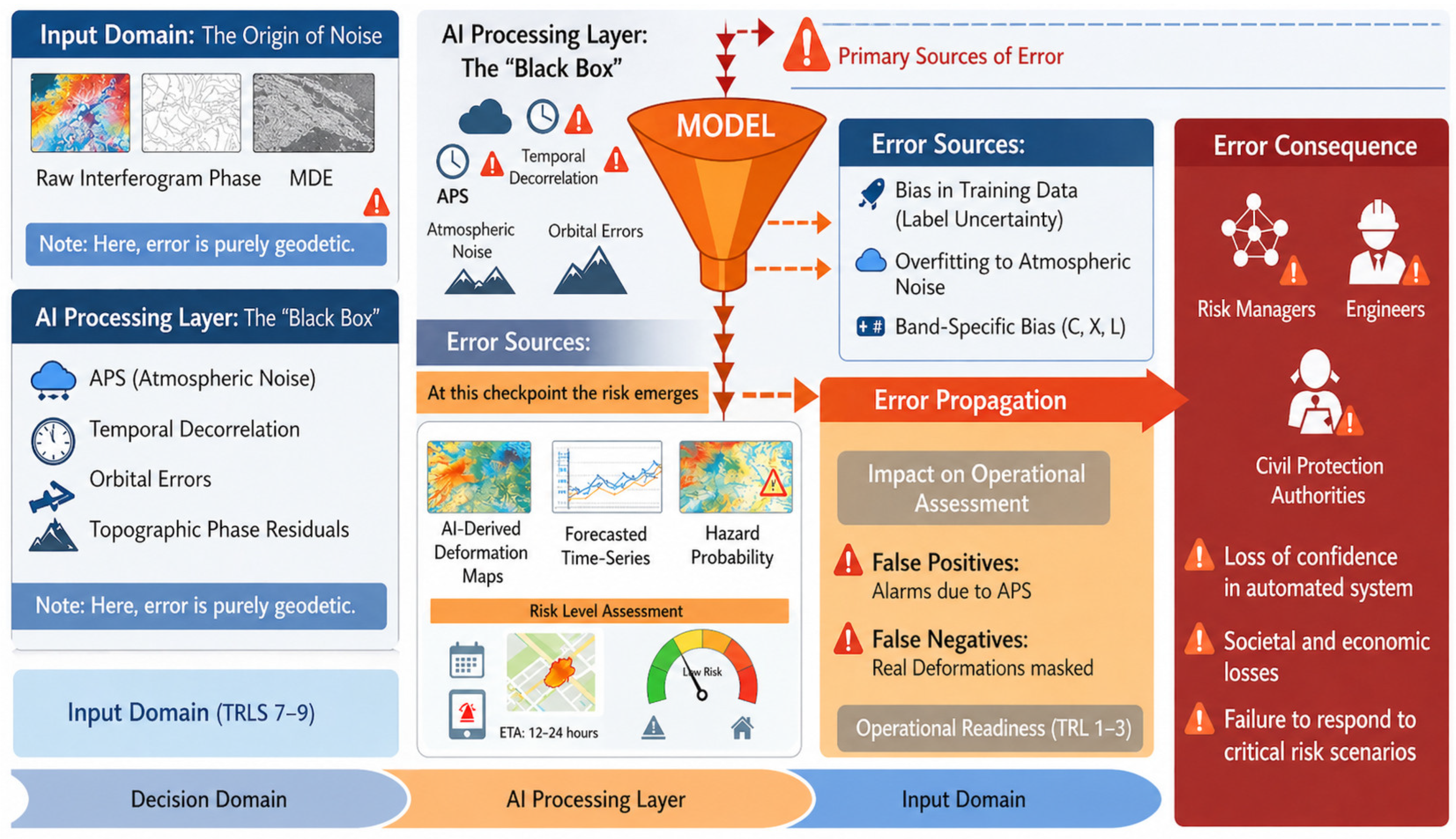
The workflow of AI-enabled InSAR is inherently susceptible to a filtering effect of uncertainty, as illustrated in Figure 3. Geodetic noise originating in the input domain is processed through the algorithmic layer, where model biases can lead to the manifestation of false positives or negatives. Incorporating uncertainty quantification is vital for increasing the trustworthiness of these systems, allowing for informed risk assessment in safety-critical applications [16,17,93]. As depicted in Figure 3, the transition from geodetic noise to decision-making impacts the Technological Readiness Level (TRL), highlighting how residual errors in the processing layer can diminish the overall operational readiness of the system for geohazard management.

6.5. Model Transferability and Generalisation Across Sensors and Environments

A critical challenge highlighted by the reviewed studies is the limited transferability of AI models across different geophysical settings, sensor configurations, and environmental conditions. This issue, frequently termed domain shift, arises because InSAR data are highly sensitive to the specific conditions of acquisition, including sensor geometry, atmospheric variability, and surface scattering properties. Consequently, models trained on data from a specific region or sensor configuration often fail to generalise effectively when deployed in new areas or with different SAR systems. This limitation represents one of the primary barriers to achieving global applicability for AI-based InSAR monitoring.
Beyond descriptive differences between regions or sensors, domain shift arises from fundamental physical mechanisms inherent to SAR imaging. First, wavelength-dependent scattering governs the stability of phase measurements: L-band penetrates vegetation more effectively than C- or X-band, producing systematically different coherence distributions even for identical terrain. Second, incidence-angle geometry modifies foreshortening, layover, shadowing, and phase gradients, leading AI models to encode acquisition-dependent spatial textures rather than deformation signals. Third, surface roughness, lithological variability, and vegetation structure alter the backscattering regime, shifting the statistical properties of PS and DS targets and thereby the latent feature space learned by CNNs, Transformers, and GNNs. Fourth, temporal sampling differences (e.g., 6-day vs. 12-day revisit) change the observable frequency content of displacement, meaning that models may not generalise to accelerations outside their training Nyquist frequency. Finally, processing-chain choices, such as multilooking, coherence estimation, and spatial filtering, introduce systematic biases that are reflected in the learned representations. These coupled mechanisms explain why models trained on one sensor, geometry, or morphoclimatic setting frequently exhibit significant performance degradation when deployed elsewhere [5,10].
Achieving global scalability requires overcoming multi-dimensional gaps ranging from hardware specifications to temporal sampling rates. Table 11 synthesises the primary transferability challenges alongside emerging mitigation strategies and remaining scientific gaps.
To quantitatively evaluate domain shift, several standardised metrics can be incorporated into AI-based MT InSAR workflows. Cross-sensor performance drop provides a direct measure of how accuracy degrades when a model trained on one mission or wavelength is tested on another. Spatially independent validation error quantifies generalisation across geographically disjoint areas and prevents inflated performance estimates caused by spatial autocorrelation. Distribution divergence metrics such as Maximum Mean Discrepancy and Fréchet Feature Distance can numerically indicate differences between latent feature representations extracted from distinct domains. Temporal generalisation ratios provide a simple way to measure the ability of a model to reconstruct or forecast deformation sampled at revisit intervals different from those used during training. Together, these metrics offer reproducible and interpretable indicators of domain shift and enable more consistent benchmarking across studies.
In landslide monitoring, for instance, a model trained on datasets with specific surface types may underperform in regions with different vegetation cover or soil composition. This is particularly problematic in areas where spatial variability is high, and the effectiveness of InSAR varies significantly with local conditions. Similarly, in volcanic deformation detection, models trained on one volcanic system may struggle when applied to another where the deformation mechanisms and geophysical properties differ considerably [21,49,57,130,131]. Studies by Liu et al. [14] and Zheng et al. [20] show that this transferability issue is exacerbated by the varying quality of training data, which limits the model ability to capture the full range of potential deformation patterns.
The issue of domain shift is particularly pronounced when applying AI to newer satellite systems or different acquisition geometries. Data from the Copernicus Sentinel-1 mission provide greater temporal resolution but introduce specific noise sources not present in older datasets. The differences in acquisition geometry between missions like RADARSAT-1 and Sentinel-1 can introduce discrepancies in how deformation is captured, making it difficult for a model trained on one system to perform reliably on another [8,9,10,21]. This challenge is compounded by regional atmospheric variability, which leads to differences in phase noise, further diminishing model transferability.
To address these challenges, transfer learning has emerged as a potential solution, allowing models to leverage knowledge gained from one domain and apply it to a new domain with minimal retraining. However, the success of transfer learning in InSAR remains mixed. While some studies report promising results, others highlight the need for methods that better account for the specific characteristics of different geophysical environments. For instance, Zhu et al. [13] and Liu et al. [14] have explored transfer learning methods that adapt model parameters based on specific acquisition conditions, yet these approaches require extensive testing across diverse regions to establish reliability.
In addition to transfer learning, domain adaptation techniques focusing on aligning feature distributions between training and testing domains have been proposed. These methods aim to reduce discrepancies caused by domain shift by adjusting the model feature space to match the characteristics of the target domain [12,19]. While these techniques show promise, their application in InSAR is in its early stages. Ultimately, improving transferability requires more diverse and comprehensive training datasets that incorporate different geophysical environments, sensor configurations, and temporal scenarios. Integrated training pipelines and systematic benchmarking across regions and geohazard types will be critical for validating the generalisation performance of AI models and for identifying strategies to overcome domain shift.

6.6. Transparency Through XAI and Decision Relevance

The integration of AI into MT InSAR workflows has increased the need for transparent and interpretable models, particularly in applications where outputs inform risk-sensitive decisions. Black box architectures can achieve strong predictive performance, but their lack of interpretability raises concerns about whether the learned representations correspond to physically meaningful deformation patterns or to artefacts arising from APS, decorrelation or geometric distortions, issues consistently highlighted in remote sensing and deep learning research [12,22]. Ensuring decision relevance therefore requires interpretability approaches that allow domain experts to understand model behaviour and assess when predictions may be influenced by measurement noise.
Explainable AI methods, including saliency-based visualisation, feature attribution and example-based interpretation, have begun to appear as diagnostic tools in MT InSAR studies. These methods help evaluate whether model predictions are driven by deformation features or by noise-induced structures in wrapped phase, coherence fields or velocity maps. Across the reviewed literature, XAI tools are most effective when used as analytical instruments to reveal potential failure modes related to data imbalance, local artefacts or domain shift, rather than as post hoc justifications of model behaviour.
Despite increasing interest, the adoption of explainability remains inconsistent. Many studies do not report interpretability analyses, leaving uncertainty regarding the relationship between predictions and physical deformation processes. A key insight emerging from the corpus is that explainability becomes essential when AI models transition from research experiments to operational geohazard monitoring, where decisions require traceability and clear justification [22]. In early warning contexts, the absence of explainability increases the risk of misinterpreting noise-driven anomalies as true deformation, with direct implications for response actions.
Finally, explainability is closely interconnected with uncertainty quantification. AI models that provide confidence estimates or error bounds allow practitioners to assess the reliability of predictions and integrate them more effectively into decision-making frameworks. Forecasting studies often omit uncertainty metrics even though MT InSAR time series are subject to significant variability arising from APS and temporal decorrelation [9,10]. The convergence of XAI and uncertainty quantification therefore represents a promising trajectory for producing AI-enabled MT InSAR systems that are robust, auditable and suitable for integration into real-world risk management workflows.

6.7. PINNs and Hybrid Modelling Strategies

Hybrid modelling approaches aim to integrate machine learning with physical principles to improve robustness, transferability and physical consistency in MT InSAR-based geohazard monitoring. Physics-informed neural networks (PINNs) and related hybrid architectures incorporate geophysical constraints directly into the learning process, reducing reliance on large labelled datasets and helping prevent models from learning artefacts driven by APS, decorrelation or acquisition geometry [12,22]. By embedding physical laws into the loss function, these models encourage predictions that remain compatible with known deformation behaviour, such as elastic dislocation, poroelastic adjustment, or hydrologically driven subsidence.
Despite their potential, the practical applications of PINNs in the reviewed literature remain limited. Existing studies demonstrate that PINNs can improve stability in noisy or sparsely sampled time series and can reduce the impact of site-specific features on model predictions, especially in subsidence forecasting and in applications involving multi-source deformation constraints [16,21,47]. However, these applications remain largely exploratory and are often constrained by computational cost, simplified physical formulations and the difficulty of defining appropriate boundary conditions for complex geological settings.
A consistent insight emerging from the corpus is that hybrid approaches are most valuable when used to regularise the learning process rather than to replace data-driven modelling. They help ensure that model outputs remain physically plausible, particularly in settings where deformation patterns exhibit strong non linear dynamics or where training datasets are insufficient to capture the full range of underlying processes. At the same time, the limited number of real-world PINN applications indicates that the field remains in an early developmental stage, and that broader adoption will require improved formulations that can accommodate multiple interacting processes, heterogeneous noise conditions and multi-sensor input characteristics.
Hybrid modelling also creates a natural bridge between explainability and physical interpretability. Unlike black box deep learning architectures, hybrid models allow users to inspect explicit physical components embedded within the model, facilitating trust and transparency in operational contexts. The evidence reviewed suggests that the future trajectory of hybrid AI InSAR frameworks will depend on the ability to build scalable formulations that combine physical constraints with data-driven flexibility, enabling geophysically meaningful predictions even in adverse noise regimes or previously unseen domains.

6.8. Operational Readiness for Early Warning and Risk Management

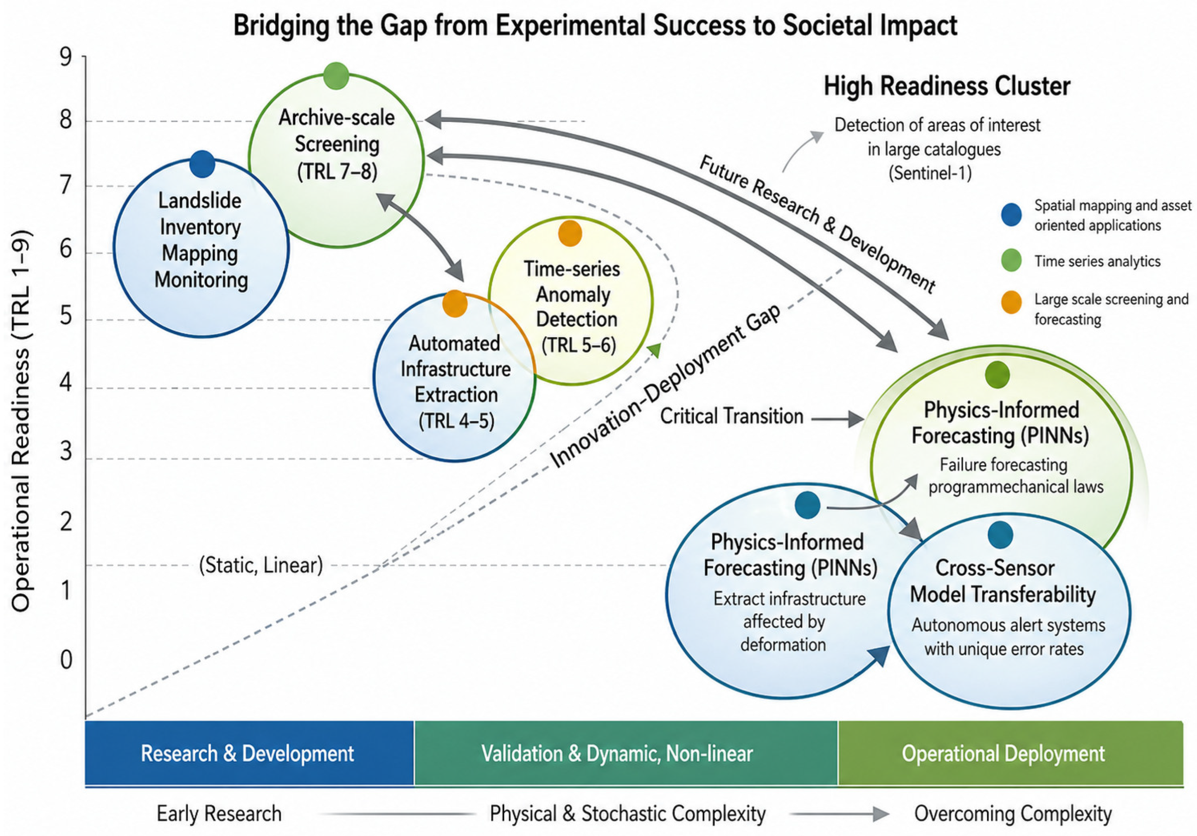
Operational deployment of AI-enabled MT InSAR systems remains challenging despite substantial progress at the research level. While many studies demonstrate promising capabilities for screening, detection and short-term analysis, the transition to real-world monitoring requires dependable performance under diverse noise regimes, acquisition geometries and environmental conditions. The reviewed evidence shows that high accuracy reported in controlled settings does not always translate into operational reliability, in part because model behaviour under unseen conditions is strongly influenced by domain shift, noise sensitivity and the absence of standardised validation frameworks [9,10,12]. Figure 4 provides a visual summary of how different classes of AI-enabled MT InSAR applications align with technological readiness levels, highlighting the persistent gap between experimental success and operational deployment. The indicative TRL assignments shown follow the conceptual TRL frameworks adopted by NASA and ESA and are intended as qualitative maturity indicators rather than formal or quantitative TRL certifications. The proposed TRL ranges synthesize evidence across the reviewed literature, considering (i) the maturity of AI–InSAR processing pipelines, (ii) the rigor and independence of validation strategies, and (iii) demonstrated robustness under real-world InSAR noise conditions. Accordingly, the horizontal axis represents a qualitative progression in physical and stochastic complexity and is not intended as a quantitative measurement scale.
Current evaluations of operational readiness often rely on case-specific demonstrations rather than systematic stress testing. As a result, models may perform well in retrospective analyses but fail to sustain accuracy when integrated into continuous monitoring pipelines that must assimilate new SAR acquisitions at regular intervals. Real-world deployment demands robustness to fluctuations in coherence, atmospheric variability and processing inconsistencies that accumulate across large spatial and temporal scales. A key insight from the literature is that achieving operational maturity depends not only on model accuracy but also on understanding how uncertainty propagates through the workflow, from raw interferograms to AI-derived outputs.
Several studies highlight the potential for integrating AI-based components into near-real-time scenarios, particularly for wide-area screening and anomaly prioritisation. However, such applications require efficient pipelines capable of processing high-volume Sentinel 1 time series with minimal latency. Operational systems also depend on the ability to communicate uncertainty, provide interpretable outputs and interface with risk management frameworks. Evidence indicates that approaches closer to operational readiness are those that combine automation with transparent quality indicators and physically informed constraints, enabling domain experts to evaluate the reliability of alerts before response actions are initiated.
Finally, progress toward operational readiness is closely linked to the availability of standardised benchmarks, shared datasets and reproducible evaluation protocols. Without these components, it remains difficult to compare approaches, quantify robustness or demonstrate generalisation across regions and sensors. Future advances will rely on community-wide efforts to harmonise validation practices, integrate uncertainty metrics and develop multi-sensor testbeds that reflect the complexity of real-world geohazard monitoring environments.

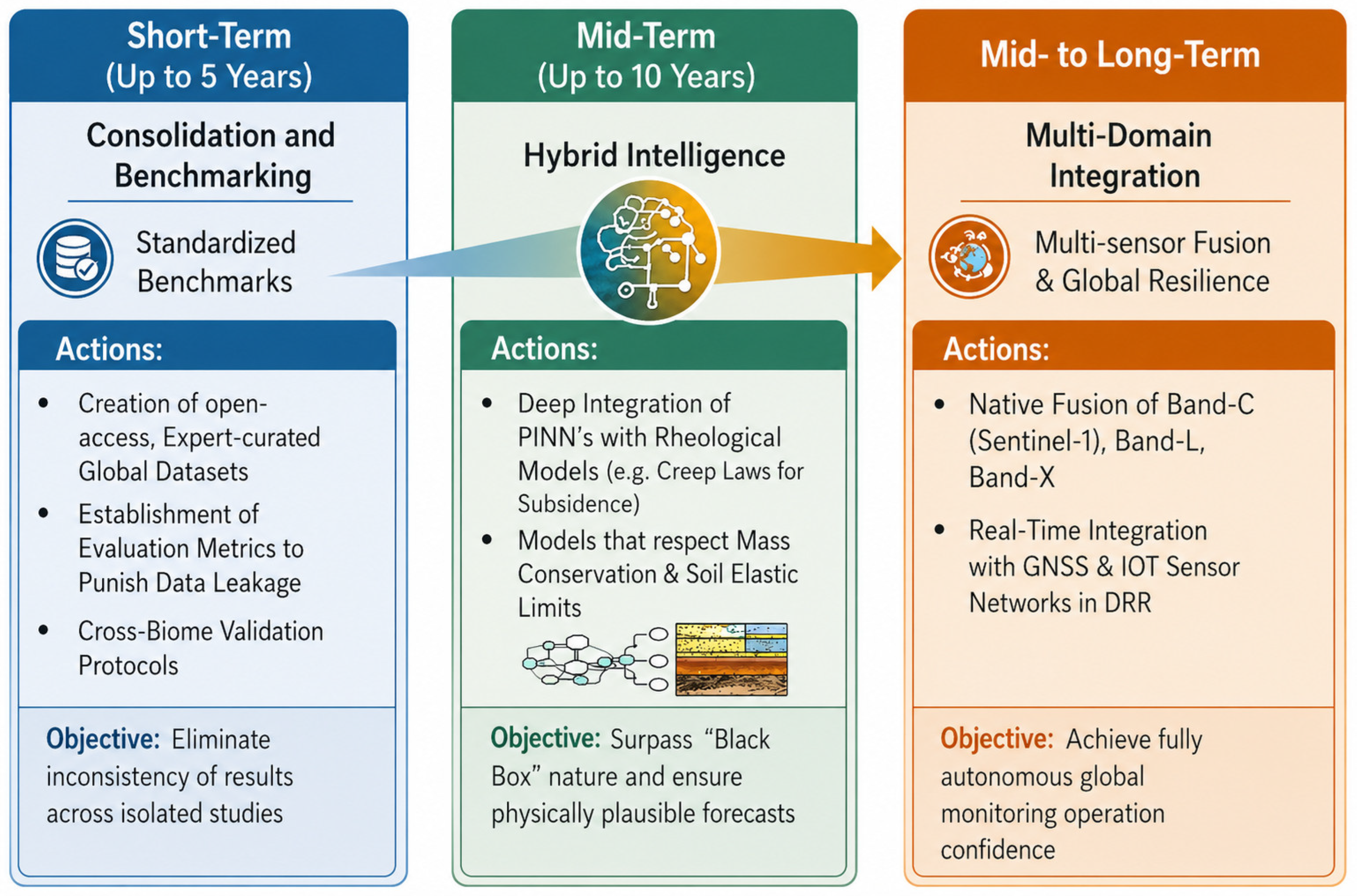
6.9. Roadmap for Future Research and Benchmarking Practices

The findings of this review highlight several structural limitations that must be addressed to advance AI-enabled MT InSAR systems toward greater robustness, transferability and operational reliability. Research to date has demonstrated substantial progress in automating detection, segmentation and short-term forecasting, yet persistent challenges remain in model generalisation, benchmarking and the treatment of uncertainty across diverse geohazard contexts. To avoid repetition of study-specific results presented in earlier sections, the following roadmap synthesises future directions that directly reflect the limitations identified throughout this review. Figure 5 summarises these priorities by linking current constraints to short, medium and long-term research actions.
A first priority concerns the creation of standardised benchmark datasets that represent the diversity of MT InSAR noise regimes, acquisition geometries and geohazard settings. Many limitations identified in Section 6.1, Section 6.2, Section 6.3, Section 6.4 and Section 6.5 arise from inconsistent reporting of training samples, limited ground truth availability and the absence of spatially independent validation [12,13]. Progress in these areas requires shared datasets with transparent metadata, consistent preprocessing and clearly defined validation splits that prevent spatial autocorrelation and data leakage. Such resources are essential for objectively comparing AI models and for quantifying their robustness under realistic operating conditions.
A second priority involves strengthening uncertainty quantification and validation standards. Forecasting studies frequently rely on single value predictions even though MT InSAR time series are highly sensitive to APS, temporal decorrelation and sampling irregularities [9,10]. Uncertainty metrics, confidence intervals and probabilistic forecasting approaches are necessary to ensure that model outputs can support decision-making. The reviewed evidence suggests that operational maturity will not be achieved without explicit integration of uncertainty quantification and validation protocols that reflect the physical characteristics of interferometric measurements.
A third research direction concerns the integration of physically informed modelling strategies, including hybrid or physics-constrained neural architectures. As discussed in Section 6.7, PINNs and related models offer potential for improving generalisation in noisy, sparse or multi-sensor environments [16,21,47], although current applications remain limited. Future developments should prioritise scalable formulations that can accommodate multiple deformation processes, heterogeneous noise conditions and multi-sensor input characteristics while remaining computationally feasible for large-scale use.
Finally, achieving long-term readiness will require the development of multi-sensor, multi-platform monitoring frameworks. Many reviewed studies rely exclusively on Sentinel 1, yet future systems will need to integrate data from emerging constellations with different wavelengths, acquisition geometries and revisit intervals. Building AI models that can generalise across sensors, terrains and temporal regimes will depend on community-wide efforts to harmonise data standards, define cross-sensor benchmarks, and develop interoperable training resources.

6.10. Methodological Limitations of the Present Systematic Review

This review is subject to several methodological limitations that should be considered when interpreting its findings. The first limitation concerns heterogeneity among the included studies. Although all selected works combine MT InSAR with machine learning or deep learning for geohazard monitoring, they differ significantly in data sources, processing chains, validation strategies and performance metrics. These inconsistencies make it difficult to directly compare results or perform a quantitative meta analysis. The lack of standardisation is a well-recognised issue in remote sensing and geohazard modelling and influences both reproducibility and cross-study comparability [12,13].
A second limitation is the uneven distribution of geohazard types and study regions across the literature. Landslides and subsidence dominate the evidence base, while volcanic and seismic deformation studies remain underrepresented. This imbalance may shape the perceived maturity of AI-enabled MT InSAR techniques because coherent urban and industrial environments tend to produce higher quality interferometric time series than vegetated or mountainous terrains. Consequently, the performance trends highlighted in this review may reflect the characteristics of available datasets rather than universal properties of the methods evaluated.
The review is also constrained by the limited availability of high-quality ground truth. Many included studies rely on historical inventories, local expert interpretation or event-based reports for model training and validation. These sources often contain inconsistencies in temporal coverage and mapping precision, as described previously in Section 6.1 and Section 6.3. Forecasting studies are particularly affected due to the strong sensitivity of MT InSAR time series to APS, decorrelation and sampling irregularities [9,10]. As a result, model performance reported in the literature may be influenced by the quality of available labels rather than by methodological differences.
Finally, the scope of the review focuses exclusively on peer-reviewed journal articles in English. Although this ensures methodological transparency, it may exclude relevant work published in other languages or in conference proceedings, especially for rapidly evolving topics such as physics-informed learning, graph-based architectures and real-time anomaly detection. These exclusions may lead to an underestimation of emerging experimental approaches that have not yet been formalised into journal publications.

7. Conclusions and Future Directions

7.1. Conclusions

This systematic review critically examined the state of AI-enabled InSAR systems for geohazard detection, synthesizing evidence from 135 studies that highlight both the rapid progress and persistent challenges in the field. AI methods, particularly DL architectures such as CNNs, LSTMs, and PINNs, have demonstrated a transformative capacity to automate the detection, delineation, and monitoring of geohazards, including landslides, volcanic unrest, and seismic deformations. These advances facilitate the transition from manual, expert-dependent analysis to high-throughput, near-real-time monitoring frameworks.
However, widespread operational deployment is currently hindered by a “reliability gap.” AI models remain sensitive to inherent InSAR noise, specifically APS, temporal decorrelation, and topographic residuals, which frequently lead to false positives in unseen environments. Furthermore, model generalisation remains the primary technical bottleneck, with performance often degrading when models encounter different satellite sensors (e.g., switching from C-band to L-band) or distinct geological contexts. This study concludes that while AI-enabled InSAR shows a high level of methodological maturity for archive-scale screening, it is best described as approaching operational readiness rather than fully deployed, and still requires enhanced uncertainty quantification and robust validation before use in safety-critical early warning systems.

7.2. Future Directions

To bridge the gap between experimental success and operational readiness, future research must move beyond purely data-driven approaches toward “Physically-Aware Intelligence”. Six essential directions are proposed:
  • Standardised Benchmarking: Creation of expert-curated, open-access datasets spanning diverse biomas and sensors to allow for objective model comparison and to penalise data leakage.
  • Hybrid Modelling: Integration of geomechanical laws and rheological constraints into AI architectures (PINNs) to ensure that deformation forecasts remain physically plausible.
  • Uncertainty and Interpretability: Mandatory inclusion of uncertainty bounds in model outputs and the use of XAI to foster trust among decision-makers.
  • Cross-Domain Transferability: Advancement of Domain Adaptation (DA) and meta-learning techniques to allow models to function across different satellite missions with minimal retraining.
  • Operational Latency Optimization: Development of edge-computing and streamlined pipelines to process massive data streams (e.g., Sentinel-1/NISAR) with sub-daily latency.
  • Stakeholder-Centric Design: Co-development of AI tools with emergency responders to ensure that outputs are not just accurate, but actionable within Disaster Risk Reduction (DRR) frameworks.

7.3. Final Remarks

The integration of AI with InSAR is no longer a distant prospect but a rapidly evolving reality that is poised to revolutionise geohazard monitoring. By addressing the current limitations in noise sensitivity and model transparency, these systems will provide the scalability needed to protect vulnerable communities globally. As the field moves toward a multi-sensor, physics-informed future, AI-enabled InSAR will serve as a cornerstone of modern resilient infrastructure and proactive risk management, ultimately saving lives through timely and reliable hazard intelligence.

Supplementary Materials

The following supporting information can be downloaded at: https://www.mdpi.com/article/10.3390/rs18091356/s1, Table S1: PRISMA 2020 checklist.; Table S2: Inclusion and Exclusion Criteria for the Systematic Review; Table S3: Databases and queries were used to define the parameters of this systematic review; Table S4: Keyword co-occurrence network for the retrieved literature on ML and DL integration with MT-InSAR for geohazard applications.

Author Contributions

Conceptualization, A.A.-D. and A.C.T.; methodology, A.A.-D. and A.C.T.; validation, A.A.-D., A.C.T. and J.J.S.; formal analysis, A.A.-D., A.C.T. and J.J.S.; investigation, A.A.-D. and M.F.; A.C.T.; resources, A.A.-D., A.C.T., S.W. and J.J.S.; data curation, A.A.-D., M.F. and A.C.T.; writing—original draft preparation, A.A.-D. and A.C.T.; writing—review and editing, A.A.-D., M.F., A.C.T. and J.J.S.; visualization, A.A.-D., A.C.T. and J.J.S.; supervision, A.A.-D., A.C.T. and J.J.S.; project administration, A.A.-D.; funding acquisition, A.A.-D., A.C.T. and J.J.S. All authors have read and agreed to the published version of the manuscript.

Funding

Alex Alonso Díaz acknowledges the support received through the MOBVIGO_25 and CINTEX Mobility Grant 2025, funded by Universidade de Vigo, the Xunta de Galicia and co-funded by the European Union under the Galicia ERDF Operational Programme.2024_2025. Ana Cláudia Teixeira acknowledges that this work was supported by FCT—Fundação para a Ciência e Tecnologia, Portugal, I.P. by project reference PRT/BD/154871/2023 and DOI identifier https://doi.org/10.54499/PRT/BD/154871/2023.

Data Availability Statement

Not applicable.

Conflicts of Interest

The authors declare no conflicts of interest.

Abbreviations

The following abbreviations are used in this manuscript:
AIArtificial Intelligence
APSAtmospheric Phase Screens
CNNConvolutional Neural Network
DLDeep Learning
DNNDeep Neural Network
GNNGraph Neural Networks
HPCHigh-Performance Computing
InSARInterferometric Synthetic Aperture Radar
LSTMLong Short-Term Memory
MLMachine Learning
MT-InSARMulti-temporal InSAR
PINNsPhysics-Informed Neural Networks
PSPersistent Scatterer
RFRandom Forest
SBASSmall-Baseline Subset
TRLTechnological Readiness Level
ViTVision Transformers
XAIExplainable AI

References

  1. Scaioni, M.; Longoni, L.; Melillo, V.; Papini, M. Remote Sensing for Landslide Investigations: An Overview of Recent Achievements and Perspectives. Remote Sens. 2014, 6, 9600–9652. [Google Scholar] [CrossRef]
  2. Casagli, N.; Frodella, W.; Morelli, S.; Tofani, V.; Ciampalini, A.; Intrieri, E.; Raspini, F.; Rossi, G.; Tanteri, L.; Lü, P. Spaceborne, UAV and Ground-Based Remote Sensing Techniques for Landslide Mapping, Monitoring and Early Warning. Geoenvironmental Disasters 2017, 4, 9. [Google Scholar] [CrossRef]
  3. Lacroix, P.; Handwerger, A.L.; Bièvre, G. Life and Death of Slow-Moving Landslides. Nat. Rev. Earth Environ. 2020, 1, 404–419. [Google Scholar] [CrossRef]
  4. Bamler, R.; Hartl, P. Synthetic Aperture Radar Interferometry. Inverse Probl. 1998, 14, R1–R54. [Google Scholar] [CrossRef]
  5. Rosen, P.A.; Hensley, S.; Joughin, I.; Li, F.; Madsen, S.; Rodríguez, E.; Goldstein, R.M. Synthetic Aperture Radar Interferometry. Proc. IEEE 2000, 88, 333–382. [Google Scholar] [CrossRef]
  6. Ferretti, A.; Prati, C.; Rocca, F. Permanent Scatterers in SAR Interferometry. IEEE Trans. Geosci. Remote Sens. 2001, 39, 8–20. [Google Scholar] [CrossRef]
  7. Berardino, P.; Fornaro, G.; Lanari, R.; Sansosti, E. A New Algorithm for Surface Deformation Monitoring Based on Small Baseline Differential SAR Interferograms. IEEE Trans. Geosci. Remote Sens. 2002, 40, 2375–2383. [Google Scholar] [CrossRef]
  8. Torres, R.; Snoeij, P.; Geudtner, D.; Bibby, D.; Davidson, M.; Attema, E.; Potin, P.; Rommen, B.; Floury, N.; Brown, M.; et al. GMES Sentinel-1 Mission. Remote Sens. Environ. 2012, 120, 9–24. [Google Scholar] [CrossRef]
  9. Zebker, H.A.; Villasenor, J. Decorrelation in Interferometric Radar Echoes. IEEE Trans. Geosci. Remote Sens. 1992, 30, 950–959. [Google Scholar] [CrossRef]
  10. Hanssen, R.F. Radar Interferometry; Remote Sensing and Digital Image Processing; Springer: Dordrecht, The Netherlands, 2001. [Google Scholar] [CrossRef]
  11. Lary, D.J.; Alavi, A.H.; Gandomi, A.H.; Walker, A.L. Machine Learning in Geosciences and Remote Sensing. Geosci. Front. 2016, 7, 3–10. [Google Scholar] [CrossRef]
  12. Reichstein, M.; Camps-Valls, G.; Stevens, B.; Jung, M.; Denzler, J.; Carvalhais, N.; Prabhat, M. Deep Learning and Process Understanding for Data-Driven Earth System Science. Nature 2019, 566, 195. [Google Scholar] [CrossRef] [PubMed]
  13. Zhu, X.X.; Tuia, D.; Mou, L.; Xia, G.; Zhang, L.; Xu, F.; Fraundorfer, F. Deep Learning in Remote Sensing: A Comprehensive Review and List of Resources. IEEE Geosci. Remote Sens. Mag. 2017, 5, 8–36. [Google Scholar] [CrossRef]
  14. Liu, Y.; Yao, X.; Gu, Z.; Zhou, Z.; Liu, X.; Chen, X.; Wei, S. Study of the Automatic Recognition of Landslides by Using InSAR Images and the Improved Mask R-CNN Model in the Eastern Tibet Plateau. Remote Sens. 2022, 14, 3362. [Google Scholar] [CrossRef]
  15. Kuzu, R.S.; Bagaglini, L.; Wang, Y.; Dumitru, C.O.; Braham, N.A.A.; Pasquali, G.; Santarelli, F.; Trillo, F.; Saha, S.; Zhu, X.X. Automatic Detection of Building Displacements Through Unsupervised Learning from InSAR Data. IEEE J. Sel. Top. Appl. Earth Obs. Remote Sens. 2023, 16, 6931–6947. [Google Scholar] [CrossRef]
  16. Wang, C.; Lin, N.; Li, B.; Tan, L.; Xu, Y.; Yang, K.; Ni, Q.; Ding, K.; Wang, B.; Li, N.; et al. InSAR-Supported Spatiotemporal Evolution and Prediction of Reservoir Bank Landslide Deformation. Appl. Sci. 2025, 15, 12092. [Google Scholar] [CrossRef]
  17. Zhao, Y.; Feng, G.; Wang, Y.; Wang, X.; Wang, Y.; Lu, H.; Xu, W.; Wang, H. A New Algorithm for Intelligent Detection of Geohazards Incorporating Attention Mechanism. Int. J. Appl. Earth Obs. Geoinf. 2022, 113, 102988. [Google Scholar] [CrossRef]
  18. Yu, S.; Ma, J. Deep Learning for Geophysics: Current and Future Trends. Rev. Geophys. 2021, 59, e2021RG000742. [Google Scholar] [CrossRef]
  19. Bayramov, E.; Tessari, G.; Aliyeva, S.; Duisenbiev, A.; Kada, M. Optimization of Targeted Differential Interferometric Measurements for Wellpads Detected by Mask Region-Based Convolutional Neural Network in the Tengiz Oilfield of the Caspian Sea Coast. Remote Sens. 2024, 16, 579. [Google Scholar] [CrossRef]
  20. Zeng, T.; Wu, L.; Hayakawa, Y.S.; Yin, K.; Gui, L.; Jin, B.; Guo, Z.; Peduto, D. Advanced Integration of Ensemble Learning and MT-InSAR for Enhanced Slow-Moving Landslide Susceptibility Zoning. Eng. Geol. 2024, 331, 107436. [Google Scholar] [CrossRef]
  21. Ghosh, B.; Motagh, M.; Haghighi, M.H.; Vassileva, M.; Walter, T.R.; Maghsudi, S. Automatic Detection of Volcanic Unrest Using Blind Source Separation with a Minimum Spanning Tree Based Stability Analysis. IEEE J. Sel. Top. Appl. Earth Obs. Remote Sens. 2021, 14, 7771–7787. [Google Scholar] [CrossRef]
  22. Roscher, R.; Bohn, B.; Duarte, M.F.; Garcke, J. Explainable Machine Learning for Scientific Insights and Discoveries. IEEE Access 2020, 8, 42200–42216. [Google Scholar] [CrossRef]
  23. Page, M.J.; McKenzie, J.E.; Bossuyt, P.M.; Boutron, I.; Hoffmann, T.; Mulrow, C.D.; Shamseer, L.; Tetzlaff, J.; Akl, E.A.; Brennan, S.; et al. The PRISMA 2020 Statement: An Updated Guideline for Reporting Systematic Reviews. BMJ 2021, 372, n71. [Google Scholar] [CrossRef] [PubMed]
  24. Page, M.J.; Moher, D.; Bossuyt, P.M.; Boutron, I.; Hoffmann, T.; Mulrow, C.D.; Shamseer, L.; Tetzlaff, J.; Akl, E.A.; Brennan, S.; et al. PRISMA 2020 Explanation and Elaboration: Updated Guidance and Exemplars for Reporting Systematic Reviews. BMJ 2021, 372, n160. [Google Scholar] [CrossRef]
  25. Ronneberger, O.; Fischer, P.; Brox, T. U-Net: Convolutional Networks for Biomedical Image Segmentation; Lecture Notes in Computer Science; Springer: Dordrecht, The Netherlands, 2015; pp. 234–241. [Google Scholar] [CrossRef]
  26. Liu, Y.; Zhang, J. Integrating SBAS-InSAR and AT-LSTM for Time-Series Analysis and Prediction Method of Ground Subsidence in Mining Areas. Remote Sens. 2023, 15, 3409. [Google Scholar] [CrossRef]
  27. Wei, Y.; Qiu, H.; Liu, Z.; Huangfu, W.; Zhu, Y.; Liu, Y.; Yang, D.; Kamp, U. Refined and Dynamic Susceptibility Assessment of Landslides Using InSAR and Machine Learning Models. Geosci. Front. 2024, 15, 101890. [Google Scholar] [CrossRef]
  28. Gharechaee, H.; Samani, A.N.; Sigaroodi, S.K.; Baloochiyan, A.; Moosavi, M.S.; Hubbart, J.A.; Sadeghi, S.M.M. Land Subsidence Susceptibility Mapping Using Interferometric Synthetic Aperture Radar (InSAR) and Machine Learning Models in a Semiarid Region of Iran. Land 2023, 12, 843. [Google Scholar] [CrossRef]
  29. Shakeel, A.; Walters, R.J.; Ebmeier, S.K.; Moubayed, N.A. ALADDIn: Autoencoder-LSTM-Based Anomaly Detector of Deformation in InSAR. IEEE Trans. Geosci. Remote Sens. 2022, 60, 4706512. [Google Scholar] [CrossRef]
  30. Karniadakis, G.E.; Kevrekidis, I.G.; Lu, L.; Perdikaris, P.; Wang, S.; Liu, Y. Physics-Informed Machine Learning. Nat. Rev. Phys. 2021, 3, 422–440. [Google Scholar] [CrossRef]
  31. Liu, B.; Xu, J.; Xi, J.; Zhao, C.; Feng, X.; Ren, C.; Shang, H. A Hybrid VMD-BO-GRU Method for Landslide Displacement Prediction in the High-Mountain Canyon Area of China. Remote Sens. 2025, 17, 1953. [Google Scholar] [CrossRef]
  32. Sousa, J.J.; Lin, J.; Wang, Q.; Liu, G.; Fan, J.; Bai, S.; Zhao, H.; Pan, H.; Wei, W.; Rittlinger, V.; et al. Using Machine Learning and Satellite Data from Multiple Sources to Analyze Mining, Water Management, and Preservation of Cultural Heritage. Geo-Spat. Inf. Sci. 2023, 27, 552–571. [Google Scholar] [CrossRef]
  33. Niu, C.; Yin, W.; Xue, W.; Sui, Y.; Xun, X.; Zhou, X.; Zhang, S.; Xue, Y. Multi-Window Identification of Landslide Hazards Based on InSAR Technology and Factors Predisposing to Disasters. Land 2023, 12, 173. [Google Scholar] [CrossRef]
  34. Khalili, M.A.; Voosoghi, B.; Madadi, S.; Pappalardo, G.; Calcaterra, D.; Di Martire, D. Preliminary Approach to Predict the Reactivation of Long-Term Kinematics Landslides through Noval Synergistic Stacked Deep Learning Approach. Stoch. Environ. Res. Risk Assess. 2025, 39, 6269–6297. [Google Scholar] [CrossRef]
  35. Wang, Y.; Li, S.; Li, B. Deformation Prediction of Cihaxia Landslide Using InSAR and Deep Learning. Water 2022, 14, 3990. [Google Scholar] [CrossRef]
  36. Yang, Z.; Jiang, X.; Zheng, M.; Guo, Q. Effects of SBAS-InSAR Deformation Integration Methods and Machine Learning Model Selection on Landslide Susceptibility Mapping. IEEE Access 2025, 13, 98622–98638. [Google Scholar] [CrossRef]
  37. Lin, Q.; Zhang, Z.; Yang, Z.; Zhang, X.; Rong, X.; Yang, S.; Yuan, H.; Zhu, X.; Wang, W. Co-Seismic Landslides Susceptibility Evaluation of Bayesian Random Forest Considering InSAR Deformation: A Case Study of the Luding Ms6.8 Earthquake. Geomat. Nat. Hazards Risk 2024, 15, 2383783. [Google Scholar] [CrossRef]
  38. Wang, T.; Zhang, Q.; Wu, Z. A Deep-Learning-Facilitated, Detection-First Strategy for Operationally Monitoring Localized Deformation with Large-Scale InSAR. Remote Sens. 2023, 15, 2310. [Google Scholar] [CrossRef]
  39. Anantrasirichai, N.; Biggs, J.; Kelevitz, K.; Sadeghi, Z.; Wright, T.; Thompson, J.; Achim, A.; Bull, D. Detecting Ground Deformation in the Built Environment Using Sparse Satellite InSAR Data with a Convolutional Neural Network. IEEE Trans. Geosci. Remote Sens. 2021, 59, 2940–2950. [Google Scholar] [CrossRef]
  40. Zhou, Y.; Hussain, M.A.; Chen, Z. Landslide Susceptibility Mapping with Feature Fusion Transformer and Machine Learning Classifiers Incorporating Displacement Velocity along Karakoram Highway. Geocarto Int. 2023, 38, 2292752. [Google Scholar] [CrossRef]
  41. Zhao, W.; Zhang, J.; Cai, J.; Ming, D. Hybrid-SegUFormer: A Hybrid Multi-Scale Network with Self-Distillation for Robust Landslide InSAR Deformation Detection. Remote Sens. 2025, 17, 3514. [Google Scholar] [CrossRef]
  42. Ma, F.; Sui, L.; Lian, W. Prediction of Mine Subsidence Based on InSAR Technology and the LSTM Algorithm: A Case Study of the Shigouyi Coalfield, Ningxia (China). Remote Sens. 2023, 15, 2755. [Google Scholar] [CrossRef]
  43. Chen, T.; Ning, D.; Liu, Y. Land Subsidence Predictions Based on a Multi-Component Temporal Convolutional Gated Recurrent Unit Model in Kunming City. Appl. Sci. 2024, 14, 10021. [Google Scholar] [CrossRef]
  44. Guo, A.; Sun, Q.; Hu, J.; Zheng, W.; Gui, R.; Yu, Y. MUSEnet: High Temporal-Frequency Estimation of Landslide Deformation Field Through Joint InSAR and Hydrological Observations Using Deep Learning. IEEE J. Sel. Top. Appl. Earth Obs. Remote Sens. 2024, 17, 1485–1499. [Google Scholar] [CrossRef]
  45. Wang, J.; Fan, X.; Zhang, Z.; Zhang, X.; Nie, W.; Qi, Y.; Zhang, N. Spatiotemporal Mechanism-Based Spacetimeformer Network for InSAR Deformation Prediction and Identification of Retrogressive Thaw Slumps in the Chumar River Basin. Remote Sens. 2024, 16, 1891. [Google Scholar] [CrossRef]
  46. Mao, Y.; Niu, R.; Li, B.; Li, J. Potential Landslide Identification Based on Improved YOLOv8 and InSAR Phase-Gradient Stacking. IEEE J. Sel. Top. Appl. Earth Obs. Remote Sens. 2024, 17, 10367–10376. [Google Scholar] [CrossRef]
  47. Zhang, Y.; He, Y.; Gao, F.; Huo, T.; Zhang, Q.; Lu, J.; Zhang, L. A Spatiotemporal Displacement Prediction Method for InSAR-Detected Landslides Using a Graph Neural Network Coupling Spatial and Temporal Features. Geomat. Nat. Hazards Risk 2025, 16, 2596362. [Google Scholar] [CrossRef]
  48. Leng, J.; Gao, M.; Gong, H.; Chen, B.; Zhou, C.; Shi, M.; Chen, Z.; Li, X. Spatio-Temporal Prediction of Regional Land Subsidence via ConvLSTM. J. Geogr. Sci. 2023, 33, 2131–2156. [Google Scholar] [CrossRef]
  49. Shami, S.; Shahriari, M.; Nilfouroushan, F.; Forghani, N.; Salimi, M.; Reshadi, M.A.M. Surface Displacement Measurement and Modeling of the Shah-Gheyb Salt Dome in Southern Iran Using InSAR and Machine Learning Techniques. Int. J. Appl. Earth Obs. Geoinf. 2024, 132, 104016. [Google Scholar] [CrossRef]
  50. Anantrasirichai, N.; Biggs, J.; Albino, F.; Bull, D. The Application of Convolutional Neural Networks to Detect Slow, Sustained Deformation in InSAR Time Series. Geophys. Res. Lett. 2019, 46, 11850–11858. [Google Scholar] [CrossRef]
  51. Bountos, N.I.; Michail, D.; Papoutsis, I. Learning from Synthetic InSAR with Vision Transformers: The Case of Volcanic Unrest Detection. IEEE Trans. Geosci. Remote Sens. 2022, 60, 4509712. [Google Scholar] [CrossRef]
  52. Naghibi, S.A.; Khodaei, B.; Hashemi, H. An Integrated InSAR-Machine Learning Approach for Ground Deformation Rate Modeling in Arid Areas. J. Hydrol. 2022, 608, 127627. [Google Scholar] [CrossRef]
  53. He, K.; Zhang, X.; Li, Z.; Jiang, W.; Zhou, J.; Han, B. A Mask R-CNN Network for Wide-Area Mining Subsidence Automatic Detection with InSAR Observations. IEEE Trans. Geosci. Remote Sens. 2024, 62, 4502716. [Google Scholar] [CrossRef]
  54. Li, Z.; Shi, A.; Li, X.; Dou, J.; Li, S.; Chen, T.; Chen, T. Deep Learning-Based Landslide Recognition Incorporating Deformation Characteristics. Remote Sens. 2024, 16, 992. [Google Scholar] [CrossRef]
  55. Peng, M.; Motagh, M.; Lu, Z.; Xia, Z.; Guo, Z.; Zhao, C.; Liu, Q. Characterization and Prediction of InSAR-Derived Ground Motion with ICA-Assisted LSTM Model. Remote Sens. Environ. 2024, 301, 113923. [Google Scholar] [CrossRef]
  56. Yang, F.; Zhi, M.; An, Y. Revealing Large-Scale Surface Subsidence in Jincheng City’s Mining Clusters Using MT-InSAR and VMD-SSA-LSTM Time Series Prediction Model. Sci. Rep. 2025, 15, 5726. [Google Scholar] [CrossRef]
  57. Głąbicki, D. Displacement Time Series Forecasting Using Sentinel-1 SBAS-InSAR Results in a Mining Subsidence Case Study—Evaluation of Machine Learning and Deep Learning Methods. Remote Sens. 2025, 17, 3905. [Google Scholar] [CrossRef]
  58. Hussain, M.A.; Chen, Z.; Wang, R.; Shoaib, M. PS-InSAR-Based Validated Landslide Susceptibility Mapping along Karakorum Highway, Pakistan. Remote Sens. 2021, 13, 4129. [Google Scholar] [CrossRef]
  59. Kulsoom, I.; Hua, W.; Hussain, S.; Chen, Q.; Khan, G.; Shihao, D. SBAS-InSAR Based Validated Landslide Susceptibility Mapping along the Karakoram Highway: A Case Study of Gilgit-Baltistan, Pakistan. Sci. Rep. 2023, 13, 3344. [Google Scholar] [CrossRef] [PubMed]
  60. Xiao, B.; Zhao, J.; Li, D.; Zhao, Z.; Zhou, D.; Xi, W.; Li, Y. Combined SBAS-InSAR and PSO-RF Algorithm for Evaluating the Susceptibility Prediction of Landslide in Complex Mountainous Area: A Case Study of Ludian County, China. Sensors 2022, 22, 8041. [Google Scholar] [CrossRef]
  61. Vaka, D.S.; Yaragunda, V.R.; Perdikou, S.; Papanicolaou, A.N. InSAR Integrated Machine Learning Approach for Landslide Susceptibility Mapping in California. Remote Sens. 2024, 16, 3574. [Google Scholar] [CrossRef]
  62. Ullah, I.; Chen, Z.; Hussain, M.A.; Shah, S.U.; Ali, N. Hybrid Machine Learning and SBAS-InSAR Integration for Landslide Susceptibility Mapping Along the Balakot–Naran Route, Pakistan. Remote Sens. 2025, 17, 3464. [Google Scholar] [CrossRef]
  63. Fiorentini, N.; Maboudi, M.; Leandri, P.; Losa, M.; Gerke, M. Surface Motion Prediction and Mapping for Road Infrastructures Management by PS-InSAR Measurements and Machine Learning Algorithms. Remote Sens. 2020, 12, 3976. [Google Scholar] [CrossRef]
  64. Confuorto, P.; Medici, C.; Bianchini, S.; Soldato, M.D.; Rosi, A.; Segoni, S.; Casagli, N. Machine Learning for Defining the Probability of Sentinel-1 Based Deformation Trend Changes Occurrence. Remote Sens. 2022, 14, 1748. [Google Scholar] [CrossRef]
  65. Abdalla, A.; Shami, S.; Shahriari, M.; Azar, M.K. Estimation of Land Displacement in East Baton Rouge Parish, Louisiana, Using InSAR: Comparisons with GNSS and Machine Learning Models. Egypt. J. Remote Sens. Space Sci. 2024, 27, 204–215. [Google Scholar] [CrossRef]
  66. Festa, D.; Novellino, A.; Hussain, E.; Bateson, L.; Casagli, N.; Confuorto, P.; Soldato, M.D.; Raspini, F. Unsupervised Detection of InSAR Time Series Patterns Based on PCA and K-Means Clustering. Int. J. Appl. Earth Obs. Geoinf. 2023, 118, 103276. [Google Scholar] [CrossRef]
  67. Zhang, T.; Zhang, W.; Cao, D.; Yi, Y.; Wu, X. A New Deep Learning Neural Network Model for the Identification of InSAR Anomalous Deformation Areas. Remote Sens. 2022, 14, 2690. [Google Scholar] [CrossRef]
  68. Khalili, M.A.; Guerriero, L.; Pouralizadeh, M.; Calcaterra, D.; Martire, D.D. Monitoring and Prediction of Landslide-Related Deformation Based on the GCN-LSTM Algorithm and SAR Imagery. Nat. Hazards 2023, 119, 39–68. [Google Scholar] [CrossRef]
  69. Stewart, C.; Lazzarini, M.; Luna, A.; Albani, S. Deep Learning with Open Data for Desert Road Mapping. Remote Sens. 2020, 12, 2274. [Google Scholar] [CrossRef]
  70. Lu, C.; Xu, H.; Yao, Q.; Liu, Q.; Bricker, J.D.; Jonkman, S.N.; Yin, J.; Wang, J. Tracking 30-Year Evolution of Subsidence in Shanghai Utilizing Multi-Sensor InSAR and Random Forest Modelling. Int. J. Appl. Earth Obs. Geoinf. 2025, 140, 104606. [Google Scholar] [CrossRef]
  71. Tripathi, A.; Moniruzzaman, M.; Reshi, A.R.; Malik, K.; Tiwari, R.K.; Bhatt, C.M.; Rahaman, K.R. Chamoli Flash Floods of 7th February 2021 and Recent Deformation: A PSInSAR and Deep Learning Neural Network (DLNN) Based Perspective. Nat. Hazards Res. 2023, 3, 146–154. [Google Scholar] [CrossRef]
  72. Hübinger, C.; Fluet-Chouinard, E.; Hugelius, G.; Peña, F.J.; Jaramillo, F. Automating the Detection of Hydrological Barriers and Fragmentation in Wetlands Using Deep Learning and InSAR. Remote Sens. Environ. 2024, 311, 114314. [Google Scholar] [CrossRef]
  73. Chang, S.; Lin, S.; Lin, Y. Deep Learning-Based Surface Deformation Tracking with Interferometric Fringes: A Case Study in Taiwan. Int. J. Appl. Earth Obs. Geoinf. 2025, 143, 104796. [Google Scholar] [CrossRef]
  74. Jiang, X.; Yang, Z.; Mei, H.; Zheng, M.; Yuan, J.; Wang, L. An Ensemble Learning Approach for Landslide Susceptibility Assessment Considering Spatial Heterogeneity Partitioning and Feature Selection. Remote Sens. 2025, 17, 2875. [Google Scholar] [CrossRef]
  75. Cai, J.; Ming, D.; Liu, Y.; Ling, X.; Liu, N.; Zhang, L.; Xu, L.; Li, Y.; Zhu, M. Change Detection of Slow-Moving Landslide with Multi-Source SBAS-InSAR and Light-U2Net. Int. J. Appl. Earth Obs. Geoinf. 2025, 136, 104387. [Google Scholar] [CrossRef]
  76. Gao, B.; He, Y.; Chen, X.; Zheng, X.; Zhang, L.; Zhang, Q.; Lu, J. Landslide Risk Evaluation in Shenzhen Based on Stacking Ensemble Learning and InSAR. IEEE J. Sel. Top. Appl. Earth Obs. Remote Sens. 2023, 16, 1–18. [Google Scholar] [CrossRef]
  77. Su, L.; Zhang, L.; Gui, Y.; Li, Y.; Zhang, Z.; Xu, L.; Ming, D. Landslide Hazard Analysis Combining BGA-Net-Based Landslide Susceptibility Perception and Small Baseline Subset Interferometric Synthetic Aperture Radar in the Baige Section in the Upper Reaches of Jinsha River. Remote Sens. 2024, 16, 2125. [Google Scholar] [CrossRef]
  78. Hussain, M.A.; Chen, Z.; Zheng, Y.; Shoaib, M.; Shah, S.U.; Ali, N.; Afzal, Z. Landslide Susceptibility Mapping Using Machine Learning Algorithm Validated by Persistent Scatterer In-SAR Technique. Sensors 2022, 22, 3119. [Google Scholar] [CrossRef]
  79. Lu, Z.; Yang, H.; Zeng, W.S.; Liu, P.; Wang, Y. Geological Hazard Identification and Susceptibility Assessment Based on MT-InSAR. Remote Sens. 2023, 15, 5316. [Google Scholar] [CrossRef]
  80. Gao, B.; He, Y.; Chen, X.; Chen, H.; Yang, W.; Zhang, L. A Deep Neural Network Framework for Landslide Susceptibility Mapping by Considering Time-Series Rainfall. IEEE J. Sel. Top. Appl. Earth Obs. Remote Sens. 2024, 17, 5946–5969. [Google Scholar] [CrossRef]
  81. Cai, J.; Zhang, L.; Dong, J.; Jin-chen, G.; Wang, Y.; Liao, M. Automatic Identification of Active Landslides over Wide Areas from Time-Series InSAR Measurements Using Faster RCNN. Int. J. Appl. Earth Obs. Geoinf. 2023, 124, 103516. [Google Scholar] [CrossRef]
  82. Miao, F.; Ruan, Q.; Wu, Y.; Zhao, Q.; Kong, Z.; Qin, Z. Landslide Dynamic Susceptibility Mapping Base on Machine Learning and the PS-InSAR Coupling Model. Remote Sens. 2023, 15, 5427. [Google Scholar] [CrossRef]
  83. Guo, H.; Yuan, Y.; Wang, J.; Cui, J.; Zhang, D.; Zhang, R.; Cao, Q.; Li, J.; Dai, W.; Bao, H.; et al. Large-Scale Land Subsidence Monitoring and Prediction Based on SBAS-InSAR Technology with Time-Series Sentinel-1A Satellite Data. Remote Sens. 2023, 15, 2843. [Google Scholar] [CrossRef]
  84. Chang, F.; Dong, S.; Yin, H.; Ye, X.; Wu, Z.; Zhang, W.; Zhu, H. 3D Displacement Time Series Prediction of a North-Facing Reservoir Landslide Powered by InSAR and Machine Learning. J. Rock Mech. Geotech. Eng. 2025, 17, 4445–4461. [Google Scholar] [CrossRef]
  85. Zheng, W.; Wen, F.; Cao, Y.; Nan, Y.; Jing, P. Landslide Hazard Assessment Under Record-Breaking Extreme Rainfall: Integration of SBAS-InSAR and Machine Learning Models. Remote Sens. 2025, 17, 2265. [Google Scholar] [CrossRef]
  86. Cao, Y.; Zhao, Z.; Wen, M.; Zhao, X.; Zhou, D.; Qin, J.; Ouyang, L.B.; Cao, J. Identification and Susceptibility Assessment of Landslide Disasters in the Red Bed Formation along the Nanjian-Jingdong Expressway. Ecol. Indic. 2025, 170, 113002. [Google Scholar] [CrossRef]
  87. Zeng, J.; Tuo, W.; Wang, X.; Zhao, X. Landslide Susceptibility Assessment of Upper Yellow River Using Coupling Statistical Approaches, Machine Learning Algorithms and SBAS-InSAR Technique. Front. Earth Sci. 2025, 13, 1652646. [Google Scholar] [CrossRef]
  88. He, Y.; Zhao, Z.; Zhu, Q.; Liu, T.; Zhang, Q.; Wang, Y.; Zhang, L.; Wang, Q. An Integrated Neural Network Method for Landslide Susceptibility Assessment Based on Time-Series InSAR Deformation Dynamic Features. Int. J. Digit. Earth 2023, 17, 2295408. [Google Scholar] [CrossRef]
  89. Hussain, M.A.; Chen, Z.; Zheng, Y.; Zhou, Y.; Daud, H. Deep Learning and Machine Learning Models for Landslide Susceptibility Mapping with Remote Sensing Data. Remote Sens. 2023, 15, 4703. [Google Scholar] [CrossRef]
  90. Yu, M.; Chen, L.; Fan, X.; Ma, P.; Zhao, S.; Wu, Z.; Yang, F.; Xu, L.; Shan, M.; Xie, X.; et al. Validating and Enhancing Data-Driven Landslide Susceptibility Prediction by Model Explanation and MT-InSAR Techniques. Int. J. Digit. Earth 2025, 18, 2509857. [Google Scholar] [CrossRef]
  91. Wang, Z.; Zhu, J.; Ma, T. Mapping of Highway Slope Hazard Susceptibility Based on InSAR and Machine Learning: A Pilot Study toward Road Infrastructure Resilience. Road Mater. Pavement Des. 2024, 26, 1974–1999. [Google Scholar] [CrossRef]
  92. Jin, B.; Zeng, T.; Yin, K.; Lei, G.; Guo, Z.; Wang, T. Dynamic Landslide Susceptibility Mapping Based on the PS-InSAR Deformation Intensity. Environ. Sci. Pollut. Res. 2024, 31, 7872–7888. [Google Scholar] [CrossRef]
  93. Peters, S.; Liu, J.; Keppel, G.; Wendleder, A.; Xu, P. Detecting Coseismic Landslides in GEE Using Machine Learning Algorithms on Combined Optical and Radar Imagery. Remote Sens. 2024, 16, 1722. [Google Scholar] [CrossRef]
  94. Zhang, R.; Zhang, L.; Fang, Z.; Oguchi, T.; Merghadi, A.; Fu, Z.; Dong, A.; Dou, J. Interferometric Synthetic Aperture Radar (InSAR)-Based Absence Sampling for Machine-Learning-Based Landslide Susceptibility Mapping: The Three Gorges Reservoir Area, China. Remote Sens. 2024, 16, 2394. [Google Scholar] [CrossRef]
  95. Yin, S.; Dai, Z.; Zeng, Y. Optimized Landslide Susceptibility Prediction Based on SBAS-InSAR: Case Study of the Jiuzhaigou Ms7.0 Earthquake. Geomat. Nat. Hazards Risk 2024, 15, 2366362. [Google Scholar] [CrossRef]
  96. Hu, J.; Yu, Y.; Gui, R.; Zheng, W.; Guo, A. Spatial Distribution Analysis of Landslide Deformations and Land-Use Changes in the Three Gorges Reservoir Area by Using Interferometric and Polarimetric SAR. Remote Sens. 2023, 15, 2302. [Google Scholar] [CrossRef]
  97. Yao, J.; Yao, X.; Zhao, Z.; Liu, X. Performance Comparison of Landslide Susceptibility Mapping under Multiple Machine-Learning Based Models Considering InSAR Deformation: A Case Study of the Upper Jinsha River. Geomat. Nat. Hazards Risk 2023, 14, 2212833. [Google Scholar] [CrossRef]
  98. Chen, L.; Ma, P.; Yu, C.Y.; Zheng, Y.; Zhu, Q.; Ding, Y. Landslide Susceptibility Assessment in Multiple Urban Slope Settings with a Landslide Inventory Augmented by InSAR Techniques. Eng. Geol. 2023, 327, 107342. [Google Scholar] [CrossRef]
  99. Lin, Y.; Chen, Y.; Yang, K.; Chen, C.; Han, J. Integrating InSAR Observables and Multiple Geological Factors for Landslide Susceptibility Assessment. Appl. Sci. 2021, 11, 7289. [Google Scholar] [CrossRef]
  100. Crippa, C.; Valbuzzi, E.; Frattini, P.; Crosta, G.B.; Spreafico, M.C.; Agliardi, F. Semi-Automated Regional Classification of the Style of Activity of Slow Rock-Slope Deformations Using PS InSAR and SqueeSAR Velocity Data. Landslides 2021, 18, 2445–2463. [Google Scholar] [CrossRef]
  101. Nhu, V.; Mohammadi, A.; Shahabi, H.; Ahmad, B.B.; Al-Ansari, N.; Shirzadi, A.; Clague, J.J.; Jaafari, A.; Chen, W.; Nguyen, H. Landslide Susceptibility Mapping Using Machine Learning Algorithms and Remote Sensing Data in a Tropical Environment. Int. J. Environ. Res. Public Health 2020, 17, 4933. [Google Scholar] [CrossRef]
  102. Ahmad, H.; Zhang, Y.; Rehman, H.; Alam, M.; Ullah, Z.; Shahid, M.A.; Khan, M.; Siddique, A. A Hybrid Spatio-Temporal Graph Attention (ST D-GAT Framework) for Imputing Missing SBAS-InSAR Deformation Values to Strengthen Landslide Monitoring. Remote Sens. 2025, 17, 2613. [Google Scholar] [CrossRef]
  103. Zhao, G.; Lan, H.; Yin, H.; Li, L.; Strom, A.; Sun, W.; Tian, C.X.J.C.Y. Deformation, Structure and Potential Hazard of a Landslide Based on InSAR in Banbar County, Xizang (Tibet). China Geol. 2024, 7, 203–221. [Google Scholar] [CrossRef]
  104. Stephenson, O.L.; Köhne, T.; Zhan, E.; Cahill, B.; Yun, S.; Ross, Z.E.; Simons, M. Deep Learning-Based Damage Mapping with InSAR Coherence Time Series. IEEE Trans. Geosci. Remote Sens. 2022, 60, 5207917. [Google Scholar] [CrossRef]
  105. Dai, Y.; Dai, W.; Yu, W.; Bai, D. Determination of Landslide Displacement Warning Thresholds by Applying DBA-LSTM and Numerical Simulation Algorithms. Appl. Sci. 2022, 12, 6690. [Google Scholar] [CrossRef]
  106. Han, J.; Yang, H.; Liu, Y.; Lu, Z.; Zeng, K.; Jiao, R. A Deep Learning Application for Deformation Prediction from Ground-Based InSAR. Remote Sens. 2022, 14, 5067. [Google Scholar] [CrossRef]
  107. Moualla, L.; Rucci, A.; Naletto, G.; Anantrasirichai, N. Learning Ground Displacement Signals Directly from InSAR-Wrapped Interferograms. Sensors 2024, 24, 2637. [Google Scholar] [CrossRef] [PubMed]
  108. Yang, X.; Chen, D.; Dong, Y.; Xue, Y.; Qin, K. Identification of Potential Landslide in Jianzha County Based on InSAR and Deep Learning. Sci. Rep. 2024, 14, 21346. [Google Scholar] [CrossRef]
  109. Fan, P.; Lin, H.; Zhang, Z.; Deng, H. Enhanced Detection of Permafrost Deformation with Machine Learning and Interferometric SAR Along the Qinghai–Tibet Engineering Corridor. Remote Sens. 2025, 17, 2231. [Google Scholar] [CrossRef]
  110. Chi, S.; An, D.; Wang, L.; Du, S.; Yuan, J.; Zheng, M.; Guo, Q. An Intelligent Identification Method for Coal Mining Subsidence Basins Based on Deformable DETR and InSAR. Remote Sens. 2025, 17, 3953. [Google Scholar] [CrossRef]
  111. Ni, J.; Bao, S.; Liu, X.; Du, S.; Tao, D.; Zhan, Y. JOTGLNet: A Guided Learning Network with Joint Offset Tracking for Multiscale Deformation Monitoring. Remote Sens. 2025, 17, 3340. [Google Scholar] [CrossRef]
  112. Liu, L.; Zhou, W.; Gutierrez, M. Mapping Tunneling-Induced Uneven Ground Subsidence Using Sentinel-1 SAR Interferometry: A Twin-Tunnel Case Study of Downtown Los Angeles, USA. Remote Sens. 2022, 15, 202. [Google Scholar] [CrossRef]
  113. Majumdar, S.; Smith, R.; Conway, B.D.; Lakshmi, V. Advancing Remote Sensing and Machine Learning-driven Frameworks for Groundwater Withdrawal Estimation in Arizona: Linking Land Subsidence to Groundwater Withdrawals. Hydrol. Process. 2022, 36, e14757. [Google Scholar] [CrossRef]
  114. Kopeć, A.; Trybała, P.; Głąbicki, D.; Buczyńska, A.; Owczarz, K.; Bugajska, N.; Kozińska, P.; Chojwa, M.; Gattner, A. Application of Remote Sensing, GIS and Machine Learning with Geographically Weighted Regression in Assessing the Impact of Hard Coal Mining on the Natural Environment. Sustainability 2020, 12, 9338. [Google Scholar] [CrossRef]
  115. Jeong, W.; Song, M.-S.; Yum, S.-G.; Adhikari, M.D. Ground Settlement Susceptibility Assessment in Urban Areas Using PSInSAR and Ensemble Learning: An Integrated Geospatial Approach. Buildings 2025, 15, 4364. [Google Scholar] [CrossRef]
  116. He, Y.; Gao, B.; Yan, H.; Zhang, Q.; Zhang, L.; Li, W.; He, X.; Lu, J. DBPFNet: A Double Branch Parallel Fusion Neural Network Method for Land Subsidence Susceptibility Mapping with InSAR Observation Data. Int. J. Digit. Earth 2025, 18, 2499199. [Google Scholar] [CrossRef]
  117. Chen, C.; Peng, M.; Motagh, M.; Guo, X.; Xing, M.; Quan, Y. Mapping Susceptibility and Risk of Land Subsidence by Integrating InSAR and Hybrid Machine Learning Models: A Case Study in Xi’an, China. IEEE J. Sel. Top. Appl. Earth Obs. Remote Sens. 2025, 18, 3625–3639. [Google Scholar] [CrossRef]
  118. Chai, L.; Xie, X.; Wang, C.; Tang, G.; Song, Z. Ground Subsidence Risk Assessment Method Using PS-InSAR and LightGBM: A Case Study of Shanghai Metro Network. Int. J. Digit. Earth 2024, 17, 2297842. [Google Scholar] [CrossRef]
  119. Alesheikh, A.A.; Chatrsimab, Z.; Rezaie, F.; Lee, S.; Jafari, A.; Panahi, M. Land Subsidence Susceptibility Mapping Based on InSAR and a Hybrid Machine Learning Approach. Egypt. J. Remote Sens. Space Sci. 2024, 27, 255–267. [Google Scholar] [CrossRef]
  120. Cieślik, K.; Milczarek, W.; Warchała, E.; Kosydor, P.; Rożek, R. Identifying Factors Influencing Surface Deformations from Underground Mining Using SAR Data, Machine Learning, and the SHAP Method. Remote Sens. 2024, 16, 2428. [Google Scholar] [CrossRef]
  121. Hakim, W.L.; Fadhillah, M.F.; Lee, K.; Lee, S.; Chae, S.; Lee, C. Land Subsidence and Groundwater Storage Assessment Using ICOPS, GRACE, and Susceptibility Mapping in Pekalongan, Indonesia. IEEE Trans. Geosci. Remote Sens. 2023, 61, 5218225. [Google Scholar] [CrossRef]
  122. Fu, G.; Schmid, W.; Castellazzi, P. Understanding the Spatial Variability of the Relationship between InSAR-Derived Deformation and Groundwater Level Using Machine Learning. Geosciences 2023, 13, 133. [Google Scholar] [CrossRef]
  123. Ranjgar, B.; Razavi-Termeh, S.V.; Foroughnia, F.; Sadeghi-Niaraki, A.; Perissin, D. Land Subsidence Susceptibility Mapping Using Persistent Scatterer SAR Interferometry Technique and Optimized Hybrid Machine Learning Algorithms. Remote Sens. 2021, 13, 1326. [Google Scholar] [CrossRef]
  124. Hakim, W.L.; Achmad, A.R.; Lee, C. Land Subsidence Susceptibility Mapping in Jakarta Using Functional and Meta-Ensemble Machine Learning Algorithm Based on Time-Series InSAR Data. Remote Sens. 2020, 12, 3627. [Google Scholar] [CrossRef]
  125. Smith, R.; Majumdar, S. Groundwater Storage Loss Associated with Land Subsidence in Western United States Mapped Using Machine Learning. Water Resour. Res. 2020, 56, e2019WR026621. [Google Scholar] [CrossRef]
  126. Jin, L.; He, Y.; Yang, J.; Wang, Y.; Chen, H.; Huo, T.; Zhang, Y.; Shi, W. A BiGRU-Based Spatiotemporal Prediction Method for Surface Displacement in Coal Mining Areas Considering Multiscale Seasonal Characteristics. IEEE J. Sel. Top. Appl. Earth Obs. Remote Sens. 2025, 18, 23107–23132. [Google Scholar] [CrossRef]
  127. Wen-Jiang, L.; Yu, X.; Ming-Fei, Z.; Li, X.; Guang-hui, Z.; Lin-Lin, W. SHAP-Enhanced Interpretive MGTWR-CNN-BILSTM-AM Framework for Predicting Surface Subsidence: A Case Study of Shanghai Municipality. Sci. Rep. 2025, 15, 19771. [Google Scholar] [CrossRef]
  128. Soni, R.; Alam, M.S.; Vishwakarma, G.K. Prediction of InSAR Deformation Time-Series Using Improved LSTM Deep Learning Model. Sci. Rep. 2025, 15, 5333. [Google Scholar] [CrossRef] [PubMed]
  129. Shu, C.; Meng, Z.; Yang, Y.; Wang, Y.; Liu, S.; Zhang, X.; Zhang, Y. Deep Learning-Based InSAR Time-Series Deformation Prediction in Coal Mine Areas. Geo-Spat. Inf. Sci. 2025, 28, 2119–2141. [Google Scholar] [CrossRef]
  130. Wang, F.; Liu, Q.; Li, R.; Wang, S.; Wang, H.; Wang, J.; Ma, X.; Zhou, L.; Wang, Y. Surface Deformation Monitoring and Prediction of InSAR-Hybrid Deep Learning Model for Subsidence Funnels. Remote Sens. 2025, 17, 2972. [Google Scholar] [CrossRef]
  131. Zheng, L.; Qing, W.; Cao, C.; Shan, B.; Jin, T.; Zhu, K.; Li, Z. Development and Comparison of InSAR-Based Land Subsidence Prediction Models. Remote Sens. 2024, 16, 3345. [Google Scholar] [CrossRef]
  132. Guo, H.; Yi, B.; Yao, Q.; Gao, P.; Li, H.; Sun, J.; Zhong, C. Identification of Landslides in Mountainous Area with the Combination of SBAS-InSAR and Yolo Model. Sensors 2022, 22, 6235. [Google Scholar] [CrossRef]
  133. Yazbeck, J.; Rundle, J.B. A Fusion of Geothermal and InSAR Data with Machine Learning for Enhanced Deformation Forecasting at the Geysers. Land 2023, 12, 1977. [Google Scholar] [CrossRef]
  134. Tasan, M.; Ghorbaninasab, Z.; Haji-Aghajany, S.; Ghiasvand, A. Leveraging GNSS Tropospheric Products for Machine Learning-Based Land Subsidence Prediction. Earth Sci. Inform. 2023, 16, 3039–3056. [Google Scholar] [CrossRef]
  135. Bayaraa, M.; Rossi, C.; Kalaitzis, F.; Sheil, B. Entity Embeddings in Remote Sensing: Application to Deformation Monitoring for Infrastructure. Remote Sens. 2023, 15, 4910. [Google Scholar] [CrossRef]
  136. Li, H.; Zhu, L.; Dai, Z.; Gong, H.; Guo, T.; Guo, G.; Wang, J.; Teatini, P. Spatiotemporal Modeling of Land Subsidence Using a Geographically Weighted Deep Learning Method Based on PS-InSAR. Sci. Total Environ. 2021, 799, 149244. [Google Scholar] [CrossRef]
  137. Jin, B.; Zeng, T.; Yang, T.; Gui, L.; Yin, K.; Guo, B.; Zhao, B.; Li, Q. The Prediction of Transmission Towers’ Foundation Ground Subsidence in the Salt Lake Area Based on Multi-Temporal Interferometric Synthetic Aperture Radar and Deep Learning. Remote Sens. 2023, 15, 4805. [Google Scholar] [CrossRef]
  138. Chen, B.; Yu, H.; Zhang, X.; Li, Z.; Jian-rong, K.; Yu, Y.; Yang, J.; Lu, Q. Time-Varying Surface Deformation Retrieval and Prediction in Closed Mines through Integration of SBAS InSAR Measurements and LSTM Algorithm. Remote Sens. 2022, 14, 788. [Google Scholar] [CrossRef]
  139. Li, F.; Liu, G.; Tao, Q.; Zhai, M. Land Subsidence Prediction Model Based on Its Influencing Factors and Machine Learning Methods. Nat. Hazards 2022, 116, 3015–3041. [Google Scholar] [CrossRef]
  140. Fiorentini, N.; Maboudi, M.; Leandri, P.; Losa, M. Can Machine Learning and PS-InSAR Reliably Stand in for Road Profilometric Surveys? Sensors 2021, 21, 3377. [Google Scholar] [CrossRef]
  141. Reshi, A.R.; Sandhu, H.A.S.; Cherubini, C.; Tripathi, A. Estimating Land Subsidence and Gravimetric Anomaly Induced by Aquifer Overexploitation in the Chandigarh Tri-City Region, India by Coupling Remote Sensing with a Deep Learning Neural Network Model. Water 2023, 15, 1206. [Google Scholar] [CrossRef]
  142. Baghermanesh, S.S.; Jabari, S.; McGrath, H. Urban Flood Detection Using TerraSAR-X and SAR Simulated Reflectivity Maps. Remote Sens. 2022, 14, 6154. [Google Scholar] [CrossRef]
  143. Zhu, X.; Zhu, W.; Guo, L.; Ke, Y.; Li, X.; Zhu, L.; Sun, Y.; Liu, Y.; Chen, B.; Tian, J.; et al. Study on Land Subsidence Simulation Based on a Back-Propagation Neural Network Combined with the Sparrow Search Algorithm. Remote Sens. 2023, 15, 2978. [Google Scholar] [CrossRef]
  144. Fadhillah, M.F.; Achmad, A.R.; Lee, C. Integration of InSAR Time-Series Data and GIS to Assess Land Subsidence along Subway Lines in the Seoul Metropolitan Area, South Korea. Remote Sens. 2020, 12, 3505. [Google Scholar] [CrossRef]
  145. Hu, Q.; Liang, H.; Li, H.; Shan, X.; Zhang, G. Aftershock Spatiotemporal Activity and Coseismic Slip Model of the 2022 Mw 6.7 Luding Earthquake: Fault Geometry Structures and Complex Rupture Characteristics. Remote Sens. 2024, 17, 70. [Google Scholar] [CrossRef]
  146. Reinisch, E.C.; Abolt, C.J.; Swanson, E.; Rouet-Leduc, B.; Snyder, E.E.; Sivaraj, K.; Solander, K. Advancing the Limits of InSAR to Detect Crustal Displacement from Low-Magnitude Earthquakes through Deep Learning. Remote Sens. 2024, 16, 2019. [Google Scholar] [CrossRef]
  147. Zhu, C.; Li, X.; Wang, C.; Zhang, B. Deep Learning-Based Coseismic Deformation Estimation from InSAR Interferograms. IEEE Trans. Geosci. Remote Sens. 2024, 62, 5203610. [Google Scholar] [CrossRef]
  148. Brengman, C.; Barnhart, W.D. Identification of Surface Deformation in InSAR Using Machine Learning. Geochem. Geophys. Geosystems 2021, 22, e2020GC009204. [Google Scholar] [CrossRef]
  149. Zhao, X.; Wang, C.; Zhang, H.; Tang, Y.; Zhang, B.; Li, L. Inversion of Seismic Source Parameters from Satellite InSAR Data Based on Deep Learning. Tectonophysics 2021, 821, 229140. [Google Scholar] [CrossRef]
  150. Petrucci, C.; Romoli, G.; Pignatelli, A.; Trasatti, E.; Zuccarello, F.; Greco, F.; Dozzo, M.; Bilotta, G.; Spina, F.; Ganci, G. Volcano Activity Classification from Synergy of EO Data and Machine Learning: An Application to Mount Etna Volcano (Italy). Discov. Appl. Sci. 2025, 7, 680. [Google Scholar] [CrossRef]
  151. Gaddes, M.; Hooper, A.; Albino, F. Simultaneous Classification and Location of Volcanic Deformation in SAR Interferograms Using a Convolutional Neural Network. Earth Space Sci. 2024, 11, e2024EA003679. [Google Scholar] [CrossRef]
  152. Beker, T.; Ansari, H.; Montazeri, S.; Song, Q.; Zhu, X.X. Deep Learning for Subtle Volcanic Deformation Detection with InSAR Data in Central Volcanic Zone. IEEE Trans. Geosci. Remote Sens. 2023, 61, 5218520. [Google Scholar] [CrossRef]
  153. Fadhillah, M.F.; Hakim, W.L.; Park, S.; Kim, D.W.; Park, Y.; Kim, C.; Lee, C. Surface Deformation Simulation for InSAR Detection Using a Machine Learning Approach on the Hantangang River Volcanic Field: A Case Study on the Orisan Mountain. Front. Environ. Sci. 2022, 10, 968120. [Google Scholar] [CrossRef]
  154. Hill, P.; Biggs, J.; Ponce-López, V.; Bull, D. Time-Series Prediction Approaches to Forecasting Deformation in Sentinel-1 InSAR Data. J. Geophys. Res. Solid Earth 2021, 126, e2020JB020176. [Google Scholar] [CrossRef]
  155. Gaddes, M.; Hooper, A.; Bagnardi, M. Using Machine Learning to Automatically Detect Volcanic Unrest in a Time Series of Interferograms. J. Geophys. Res. Solid Earth 2019, 124, 12304–12322. [Google Scholar] [CrossRef]
  156. Mirmazloumi, S.M.; Gambín, Á.F.; Palamà, R.; Crosetto, M.; Wassie, Y.; Navarro, J.A.; Barra, A.; Monserrat, O. Supervised Machine Learning Algorithms for Ground Motion Time Series Classification from InSAR Data. Remote Sens. 2022, 14, 3821. [Google Scholar] [CrossRef]
Figure 1. PRISMA flow diagram illustrating the identification, screening, eligibility and inclusion of studies retrieved from Scopus and Web of Science. All steps reflect predefined criteria applied consistently throughout the review process. The final corpus comprises 135 peer-reviewed studies combining MT-InSAR with substantive ML or DL components for geohazard-related deformation analysis.
Remotesensing 18 01356 g001
Figure 2. Keyword co-occurrence network for the retrieved literature on ML and DL integration with MT-InSAR for geohazard applications. Node colors represent the average publication year associated with each keyword. In the revised analysis, the interpretation of thematic and temporal migration is supported not only by this visual overlay but also by quantitative bibliometric indicators, including annual keyword frequencies, keyword burst detection, and temporal centroids, summarized in Section 2.1 and detailed in Supplementary Table S4.
Remotesensing 18 01356 g002
Figure 3. Integrated framework of error propagation and uncertainty quantification in AI-enabled InSAR workflows. The diagram illustrates the transition from geodetic noise (e.g., APS and temporal decorrelation) in the input domain to algorithmic biases in the processing layer, highlighting how these factors diminish the TRL and impact decision-making in safety-critical geohazard management.
Remotesensing 18 01356 g003
Figure 4. Conceptual mapping of AI-enabled MT InSAR applications onto indicative technological readiness levels. The diagram summarises how different classes of workflows, including screening, spatial delineation and temporal forecasting, progress from experimental development to operational maturity. It highlights the gap between the high accuracy often observed in controlled research settings and the more demanding conditions required for reliable deployment in continuous geohazard monitoring. The horizontal axis represents a qualitative gradient of physical and stochastic complexity in deformation and noise conditions and is not intended as a quantitative measurement scale. TRL levels are indicative and reflect qualitative maturity based on validation rigor, robustness to InSAR noise, and reported operational deployment, rather than formal TRL certification.
Remotesensing 18 01356 g004
Figure 5. Roadmap for future research in AI-enabled MT InSAR. The diagram summarises short-term, medium-term and long-term priorities identified in this review, including the creation of standardised benchmark datasets, the integration of uncertainty-aware validation, the development of physically informed modelling approaches and the implementation of multi-sensor frameworks supporting robust and transferable geohazard monitoring. The timeline for multi-frequency fusion refers to the development of native, harmonised AI-based integration of heterogeneous SAR bands, which is distinct from existing cross-sensor processing demonstrated in current studies; it therefore remains a mid to long-term research objective.
Remotesensing 18 01356 g005
Table 1. Software and Computational Ecosystem identified in the reviewed literature.
CategoryFramework/SoftwareKey ReferencesNotable Applications in Geohazards
AI FrameworksTensorFlow (2.10)[14,16,19]Mask R-CNN for landslide mapping, LSTM for time-series.
PyTorch[17,20,25]Spacetimeformer, U-Net for segmentation, SegUFormer.
Scikit-learn[11,26]Random Forest (RF) and ensemble methods for susceptibility.
Keras[27,28]Rapid prototyping of DL models.
PyTorch[13,18,29,30]PINNs for subsidence and Vision Transformers (ViT) for landslide detection.
InSAR EnginesGAMMA[4,31,32]High-precision raw SAR processing and MT-InSAR.
StaMPS[6,33]PS-InSAR analysis in urban areas.
ISCE/MintPy[34,35]Open-source time-series analysis and cloud-based workflows.
SARscape/ENVI[36,37]Commercial-grade processing for infrastructure monitoring.
Table 2. Inclusion and Exclusion Criteria for the Systematic Review.
CriterionInclusion CriteriaExclusion Criteria
Document TypePeer-reviewed journal articles.Conference papers, books, reviews, and editorials.
MethodologyJoint use of MT-InSAR (PS-InSAR, SBAS) and ML/DL architectures.Studies using only InSAR or only ML without radar data integration.
TopicGeohazard monitoring (landslides, subsidence, volcanoes, earthquakes).General SAR applications (e.g., land cover, oceanography, agriculture).
LanguageFull-text available in English.Articles in other languages or without full-text access.
Technical FocusAutomated detection, segmentation, or forecasting tasks.Purely manual interpretation or qualitative assessment studies.
Table 3. Classification of the reviewed literature (n = 135) by geohazard category, InSAR data products, and predominant AI approaches. Counts may exceed unique study totals because some works address multiple geohazard types.
Geohazard Category% of Studies (Nº.)Primary InSAR ProductsDominant AI TasksRepresentative Architectures (Key Ref.)
Landslides40 (54)Velocity maps, Phase-gradients, DEM-derived factors.Detection, inventory mapping, and dynamic susceptibility.Mask R-CNN [14], YOLOv8 [46], ViT [40], GNN [47].
Subsidence28 (38)MT-InSAR time-series (PS-InSAR/SBAS), Groundwater levels.Settlement forecasting and multi-source risk screening.Bi-GRU [31], Spacetimeformer [45], ConvLSTM [48], PINNs [49]
Volcanic Unrest13 (18)Wrapped interferograms (single or stacks), Coherence series.Anomaly detection and source parameter inversion.CNN [50], ViT [51], Autoencoders (AE) [29].
Seismic Events11 (15)Co-seismic displacement maps, Phase-gradients.Fault characterization and event-based segmentation.U-Net [25], ResNet, DeepLabV3+.
Infrastructure8 (10)High-resolution displacement (X-band), Coherence time-series.Maintenance screening and unsupervised anomaly detection.ALADDIn (AE-LSTM) [29], Isolation Forest [52], SVM [27].
Table 4. Technical taxonomy of AI paradigms for InSAR-based geohazard monitoring. Note: Categories are not mutually exclusive. Several studies, such as ALADDIn, combine temporal sequence learning with unsupervised anomaly detection. The taxonomy therefore follows a multi-label structure rather than a mutually exclusive classification.
Methodological Family (Section)Typical InSAR InputsPrimary TasksTypical Model ClassesStrengths
Spatial feature learning (Section 4.1)Interferograms, velocity maps, phase-gradientsDetection, segmentationCNN, U-Net, ViT, GNN, Mask R-CNNAutomation; precise localization
Temporal feature learning (Section 4.2)MT-InSAR displacement time seriesForecasting, trend predictionLSTM, Bi-GRU, Transformers, PINNsPredictive monitoring; early-warning
Feature-based ML (Section 4.3)Velocities, coherence + factorsSusceptibility mappingRF, XGBoost, SVMInterpretable; fast deployment
Unsupervised screening (Section 4.4)InSAR time series or raw stacksAnomaly screeningPCA + Clustering, AutoencodersScalable; no label dependence
Table 5. Summary of AI–InSAR methodological families used for geohazard monitoring, indicating typical data representations, learning objectives, model classes, evaluation practices, and recurring strengths and limitations.
Methodological FamilyTypical InSAR InputsPrimary TasksTypical Model Classes (Key Refs)Evaluation MetricsStrengths for MonitoringRecurring Limitations
Spatial Feature Learning (4.1)Interferograms, velocity maps, phase-gradientsDetection, semantic segmentation, and inventory mappingCNN, U-Net [25,38], ViT [40], Mask R-CNN [53], GNN [47]IoU, F1-score, Precision-Recall, mAPHigh automation; GNNs preserve irregular PS topologySensitivity to APS; performance drops with domain shift
Temporal Feature Learning (4.2)MT-InSAR displacement time-series (PS-InSAR/SBAS)Forecasting, trend prediction, and precursory detectionLSTM [42], Bi-GRU [31], Transformers [45], PINNs [12]MAE, RMSE, Pearson’s r, Forecast horizonCaptures non-linear dynamics; supports early-warningVulnerable to phase unwrapping errors and noise
Feature-Based ML & Ensembles (4.3)Velocity/coherence + factors (DEM, GWL)Susceptibility mapping and regional risk screeningRF [63,70], XGBoost [62], Ensemble ML [49], LightGBMAUC-ROC, Accuracy, SHAP/LIME (XAI)Handles multi-sensor data [70]; high interpretabilitySpatial autocorrelation bias; sensitive to inventory quality
Unsupervised/Weakly Supervised (4.4)Raw image stacks or unlabelled time-seriesAnomaly screening, pattern discovery, and noise reductionAutoencoders (ALADDIn) [29], PCA + Clustering [66], Isolation Forest [52]Anomaly scores, Reconstruction errorScalable to massive datasets; no label dependenceHigh false positive rate; difficult validation of events
Table 6. Summary of AI-InSAR methodological applications for landslide monitoring, categorized by operational objective: spatial detection and delineation, susceptibility and risk mapping, and kinematic forecasting. The synthesis highlights the diversity of architectures, from traditional ensemble learning to advanced spatiotemporal graph networks. Note: Reported performance metrics in the reviewed studies are not standardised, and therefore this table provides a qualitative synthesis rather than a statistical or meta-analytic comparison.
Study/SourceRegion/TargetAI ArchitectureInSAR TechniqueKey Outcome
Spatial detection and delineation
S.-T. Chang et al. [73]Central TaiwanFringe-Labeling (FLM/FDM)Wrapped D-InSARmAP 83.9% (Central)/F1 78.7% (North); Proved robust fringe-pattern recognition.
X. Jiang et al. [74]Yunnan, ChinaStacking (CNN, DNN, MLP)SBASAUC 95.90%; HF-stacking architecture effectively fused multi-scale features.
B. Liu et al. [31]SE Tibetan PlateauVMD-BO-LSTMSBASRMSE 0.402/R2 0.998; VMD-BO-LSTM optimized non-stationary signal extraction.
J. Cai et al. [75]Mining areas, ChinaLight-U2Net (CNN)SBASAccuracy 90.47%; Light-U2Net enabled high-fidelity boundary delineation in mining areas.
W. Zhao et al. [41]High-risk zones, ChinaHybrid-SegUFormer (U-Net)SBASQualitative validation; Self-distillation mechanism improved noise resilience in complex terrain.
J. Wang et al. [45]Heifangtai, ChinaSpacetimeformerSBASPrediction Error (Min); Spacetimeformer integrated spatial and temporal features for unified ID.
J.J. Sousa et al. [32]Portugal/Multi-siteECA-U-NetPS-InSAR/SBAS/D-InSARMIoU 80.58%; ECA-U-Net attention mechanism significantly improved semantic segmentation.
Y. Mao et al. [46]Chamdo, TibetYOLOv8 + CBAMPhase-gradient StackingmAP50 93.4%; YOLOv8 integration enabled rapid detection from phase-gradient stacks.
Z. Li et al. [54]Sichuan/Yunnan, ChinaFCADenseNetSBASPrecision/Recall balanced; FCADenseNet successfully linked kinematic trends to spatial ID.
B. Gao et al. [76]Shenzhen, ChinaTSDNN (Dynamic NN)MT-InSARAccuracy Gain 11.4–12.9%; TSDNN outperformed static RF/CNN via dynamic learning.
L. Su et al. [77]Western ChinaBGA-Net (CNN)SBASPerception Accuracy (High); BGA-Net enabled simultaneous susceptibility and hazard perception.
M.A. Hussain et al. [78]KKH, Pakistan/IndiaCNN-2D, RNN, RFPS-InSARAccuracy Gain 6.0%; 2D-CNN outperformed RNN in spatial signature recognition.
Z. Lu et al. [79]Beijing MountainsRF, SVM, CNNMT-InSARQualitative validation; Multi-algorithm fusion improved wide-area geological hazard screening.
B. Gao et al. [80]Active tectonic zonesSEL (Stacking Ensemble)MT-InSARROC-AUC (+8.0%); Stacking ensemble effectively mitigated false positives in tectonic zones.
C. Niu et al. [33]Yongping County, ChinaCNND-InSARPrecision 82.86%/F1 80.75%; D-InSAR/CNN pipeline automated regional inventory updates.
C. Jiehua et al. [81]Guizhou, ChinaFaster R-CNN (ResNet-34)SBASHigh Recall; Faster R-CNN automated detection of localized deformation from time-series.
F. Miao et al. [82]Wanzhou, ChinaIJRF (Ensemble)PS-InSARAUC 0.995; IJRF ensemble achieved near-perfect discrimination for Wanzhou landslides.
T. Wang et al. [38]Mountainous terrainsYOLO + DnCNNTime-series AnalysisSpeed-up 4x; YOLO + DnCNN avoided unwrapping errors via direct wrapped-phase inference.
Y. Zhou et al. [40]KKH, PakistanFFTR (Transformer)PS-InSARAUC 0.94/Acc 87.31%; FFTR Transformer effectively modeled long-range spatial dependencies.
H. Guo et al. [83]Henan, ChinaYOLOSBASMatch Rate (High); YOLO-based detection showed high correlation with official inventories.
T. Zhang et al. [67]Maoxian, ChinaInSARNet (CNN)SBASNoise-Tolerance (High); InSARNet demonstrated robustness against high atmospheric noise.
Y. Liu et al. [14]Eastern Tibet PlateauMask R-CNN+++D-InSARAccuracy 92.94%; Mask R-CNN+++ optimized instance segmentation in high-relief Tibet.
N. Anantrasirichai et al. [39]UK (National-scale)CNNMatrix CompletionAccuracy Gain 81.5%; Matrix Completion effectively reconstructed missing time-series data.
Susceptibility and risk mapping
F. Chang et al. [84]Three Gorges (Xinpu)RF, SVM, LSTMSBASRMSD 9.62 mm/Corr 0.996; Hybrid LSTM-RF improved landslide displacement modeling.
I. Ullah et al. [62]Balakot Valley, PakistanAdaBoost/LightGBMSBASAUC 0.88; AdaBoost/LightGBM fusion optimized regional susceptibility in Balakot.
W. Zheng et al. [85]Zhenba, ChinaDNN, XGBoost, RFSBASQualitative validation; Established hazard zoning thresholds under extreme rainfall events.
Y. Cao et al. [86]Western Yunnan, ChinaStacking (RF/XGB)SBASPrecision (Superior); Stacking (RF/XGB) addressed non-linearity in red bed formations.
J. Zeng et al. [87]Upper Yellow RiverCF-XGBoostSBASAUC 0.916; CF-XGBoost effectively integrated conditioning factors with InSAR rates.
Z. Yang et al. [36]Multi-region studySVM, RF, XGBoostSBASAUC > 0.85; RF and XGBoost outperformed SVM in regional susceptibility mapping.
He et al. [88]China (Regional)Integrated NN (Dynamic)Time-series InSARDynamic AUC Gain; Proved that dynamic InSAR features refine susceptibility over static models.
Hussain et al. [89]Karakoram HighwayDL vs. ML BenchmarkPS-InSARAccuracy Gain 9.0%; DL architectures (CNN) outperformed traditional ML benchmarks.
M. Yu et al. [90]Not SpecifiedXGBoost (XAI)MT-InSARDetection Gain 13%; XAI-based XGBoost improved high-risk zone identification.
Zhipeng Wang et al. [91]Highway InfrastructureCatBoost/ANNSBASAUC 0.85; CatBoost integration improved road infrastructure resilience assessment.
Q. Lin et al. [37]Luding (Earthquake)BO-RF (Bayesian RF)SBASAUC 0.984/Acc 0.952; Bayesian-optimized RF maximized post-seismic mapping accuracy.
Bijing Jin et al. [92]Wanzhou, ChinaDT, MLPNN, LRPS-InSARAUC 93.1% (+2.0%); Dynamic InSAR predictors reduced false alarm rates in Wanzhou.
Taorui Zeng et al. [20]Dazhou/Wanzhou, ChinaStacking/EnsembleMT-InSARAccuracy (High); Stacking models improved zoning for slow-moving landslide activity.
Y. Wei et al. [27]Hualong, ChinaGBDT, RF, LRSBASError Reduction; GBDT/RF ensemble minimized false positive susceptibility assignments.
Stefan Peters et al. [93]JPN/HTI/PNG/NZLRF/SVMOptical + RadarAccuracy 87–92%; Demonstrated cross-region coseismic landslide detection capability.
R. Zhang et al. [94]Three Gorges (TGRA)RF, SVM, LRSBASAUC (+1.0%); InSAR-derived sampling strategy improved training label representativeness.
S. Yin et al. [95]Jiuzhaigou (Earthquake)SVM/RFSBASAccuracy Gain (Significant); Proved surface deformation as a critical predictor for SVM/RF.
I. Kulsoom et al. [59]Gilgit-Baltistan, PKXGBoostSBASValidation R2 (High); XGBoost effectively mapped landslide propensity along the KKH.
J. Hu et al. [96]Three Gorges (TGRA)RF/K-MeansSBASPattern Discovery; K-Means/RF link land-use changes to specific deformation clusters.
J. Yao et al. [97]Upper Jinsha RiverRF, XGBoost, SVMMT-InSARAccuracy Gain; Integrating MT-InSAR rates refined susceptibility in the Jinsha River area.
Li Chen et al. [98]Hong KongSVM, MLP, DBNMulti-InSARAccuracy +3–6%; DBN architecture optimized susceptibility in dense urban HK settings.
B. Xiao et al. [60]Mountainous AreasPSO-RFSBASAUC 0.9567; PSO-RF optimization outperformed traditional backpropagation models.
P. Confuorto et al. [64]Tuscany, ItalyRFSqueeSARProbability Output; SqueeSAR/RF provided statistical confidence for deformation changes.
M.A. Hussain et al. [58]Karakoram HighwayRF/XGBoostPS-InSARAccuracy > 80%; RF/AdaBoost integration proved effective for Taiwan’s complex geology.
Y.-T. Lin et al. [99]TaiwanRF/AdaBoostMT-InSARAccuracy > 80%; DT/SVM successfully classified rock-slope kinematic activity levels.
C. Crippa et al. [100]Alpine/PrealpineDecision Trees/SVMPS-InSAR/SqueeSARAUC 0.96; AdaBoost showed superior performance in high-moisture tropical terrains.
V.-H. Nhu et al. [101]Cameron Highlands, MYAdaBoost/ADTreeInSAR InventoryRMSD 9.62 mm/Corr 0.996; Hybrid LSTM-RF improved landslide displacement modeling.
Forecasting and temporal modelling
Y. Zhang et al. [47]Heifangtai (Loess)GCN + Self-AttnSBASRMSE 0.13 mm; GCN + Self-Attention captured complex loess deformation trends.
H. Ahmad et al. [102]Reservoir SlopesST-GAT (Graph Attn)SBASROC-AUC 0.91; ST-GAT successfully imputed missing InSAR data via graph attention.
G.-H. Zhao et al. [103]Fragile environmentsLSTMSBASMAE (Reduced); LSTM demonstrated superior sequence learning in fragile environments.
A. Guo et al. [44]Three Gorges (TGRA)MUSEnet (LSTM)MT-InSARRMSE 0.70 mm; MUSEnet (LSTM) outperformed Kalman Filter in multi-step forecasting.
Khalili et al. [68]Southern Italy (Campania)GCN-LSTMMT-InSARMAE < 4 mm (92% pts); Spatiotemporal GCN-LSTM captured non-linear slope evolution.
M.A. Khalili et al. [34]Southern ApenninesGCN-LSTMPS-InSARF1-Score (High); RNN (GRU) enabled rapid damage detection from coherence sequences.
O.L. Stephenson et al. [104]Damage detectionRNN (GRU)Coherence TSAccuracy > 95%; DBA-LSTM optimized landslide warning thresholds via DL.
Yue Dai et al. [105]Shangtan, ChinaDBA-LSTMMT-InSARRMSE/MAE (Min); LSTM-ARIMA hybrid addressed both seasonal and stochastic signals.
Y. Wang et al. [35]Cihaxia StationLSTM + ARIMAMT-InSARResidual SD 0.46 mm; LSTM effectively forecasted displacement in high-coherence sites.
J. Han et al. [106]Guangyuan, ChinaLSTMPS-InSAR/SBASMAE < 4 mm (92% pts); GCN-LSTM effectively modeled long-term slope kinematics.
Other and mixed
D.S. Vaka et al. [61]California, USAXGBoostMT-InSARRegional AUC (High); XGBoost enabled national-scale susceptibility screening in the USA.
L. Moualla et al. [107]Main RoadsK-NNParallel SBASPrecision (Improved); k-NN applied to wrapped phase bypassed unwrapping bottlenecks.
X. Yang et al. [108]Jianzha County, ChinaResNet50PS-InSAR/SBASAccuracy 94.4% (Test); ResNet50 demonstrated high transferability across diverse basins.
Table 7. Summary of AI–InSAR methodological applications for land subsidence and infrastructure settlement, categorized by operational objective: monitoring and detection, susceptibility and risk mapping, and kinematic forecasting. The synthesis reflects a trend toward hybrid DL architectures for urban and industrial stability assessment. Note: Reported performance metrics in the reviewed studies are not standardised, and therefore this table provides a qualitative synthesis rather than a statistical or meta-analytic comparison.
Study/SourceApplicationAI ArchitectureInSAR TechniqueKey Finding
Monitoring and detection
P. Fan et al. [109]QTEC, TibetSVR, Faster R-CNNMT-InSARQualitative validation; Achieved high spatial precision in automated permafrost thaw detection.
S. Chi et al. [110]Huainan, ChinaDeformable DETRSBASF1-score 0.905/mIoU 0.828; Deformable DETR improved coal mining basin identification.
J. Ni et al. [111]Daliuta, ChinaJOTGLNetOffset TrackingPrediction Error < 0.15 m; JOTGLNet optimized multiscale monitoring for large deformations.
A. Abdalla et al. [65]Louisiana, USAKNN, GBR, RFSBASValidation (High); ML displacement estimates showed strong correlation with GNSS benchmarks.
K. He et al. [53]Shanxi, ChinaMask R-CNNMT-InSARQualitative validation; Mask R-CNN effectively automated wide-area mining boundary delineation.
L. Liu et al. [112]Los Angeles, USADecision Tree (PFI)PS-InSARPFI Ranking; Identified tunneling-induced drivers via Permutation Feature Importance.
S. Majumdar et al. [113]Arizona, USARFSBASCorrelation (High); Quantified the direct link between groundwater withdrawal and subsidence.
A. Kopeć et al. [114]Lublin, PolandRFSBASAccuracy 99.96%; Proved RF effectiveness in mapping mining impacts on floodplains.
Susceptibility and risk mapping
Jeong et al. [115]Pohang, S. KoreaRF, XGBoost, DTPS-InSARValidation (High); RF achieved superior agreement with field evidence for urban settlement risk.
Y. He et al. [116]Beijing, ChinaDBPFNet (CNN + LSTM)MT-InSARAccuracy (Improved); DBPFNet multi-branch fusion refined susceptibility in the Beijing Plain.
C. Lu et al. [70]Shanghai, ChinaRFMulti-sensor InSARLong-term Trend Analysis; Identified 30-year risk drivers via multi-sensor InSAR integration.
C. Chen et al. [117]Xi’an, ChinaHybrid RFSBASRisk Zoning (Precise); Hybrid RF effectively combined geomorphology with InSAR rates.
L. Chai et al. [118]Shanghai, ChinaLightGBMPS-InSARAUC 0.902; LightGBM provided high-accuracy risk assessment for metro infrastructure.
Alesheikh et al. [119]Aquifer areasANFIS-PSOQuasi-PSAUC 0.863; ANFIS-PSO optimization outperformed standard ANFIS for aquifer monitoring.
K. Cieślik et al. [120]SW PolandXGBoost + SHAPSBASSHAP Attribution; Identified key mining variables influencing surface deformation patterns.
W.L. Hakim et al. [121]Pekalongan, Indo.CNN-GWO/ICATime-series InSARRMSE 0.305; CNN-GWO optimization achieved the highest precision for coastal subsidence.
H. Gharechaee et al. [28]Bakhtegan, IranRF, KNN, CARTSBASCORR 0.88; RF/KNN demonstrated strong predictive power for semiarid subsidence risk.
G. Fu et al. [122]NSW, AustraliaRFPS-InSARCorrelation (High); Modeled the non-linear relationship between deformation and water levels.
B. Ranjgar et al. [123]Shahryar, IranANFIS-ICA/GWOPS-InSARAUC 0.932; ANFIS-ICA reached high precision for groundwater-induced subsidence.
W.L. Hakim et al. [124]Jakarta, Indo.AdaBoost, MLP, LRStaMPS (PS)Accuracy 81.1%; AdaBoost outperformed MLP/LR in urban susceptibility mapping.
R.G. Smith et al. [125]Western USARFSBASStorage Loss (Mapped); RF quantified regional groundwater loss via InSAR displacement.
Forecasting and temporal modelling
Z. Yang et al. [56]Jincheng, ChinaVMD-SSA-LSTMMT-InSARPrediction Accuracy (High); VMD-SSA-LSTM hybrid optimized mining time-series prediction.
L. Jin et al. [126]Coal Mine sitesBiGRUMT-InSARMAE Reduction 30.2%; Spatiotemporal BiGRU improved accuracy for mining motion sequences.
L. Wen-Jiang et al. [127]Shanghai, ChinaMGCBA (CNN-BiLSTM)SBASAccuracy 0.993/RMSE 1.86 mm; MGCBA (CNN-BiLSTM) captured urban subsidence trends.
R. Soni et al. [128]Khetri, IndiaModified LSTMStaMPS (PS)Efficiency 98.57%; Modified LSTM effectively modeled copper belt deformation kinematics.
C. Shu et al. [129]Hunchun, ChinaTransformer + BiLSTMDS-InSARPrediction Gain (Significant); Transformer-encoder improved modeling in complex goaf areas.
D. Głąbicki et al. [57]Polish Coal BasinsDNN/RegressionSBASRMSE (Lower); DNN outperformed traditional ML for coal basin displacement forecasting.
F. Wang et al. [130]Coal Basins, ChinaCNN-LSTMDS/SBASQualitative validation; CNN-LSTM enabled monitoring in high-vegetation mining zones.
T. Chen et al. [43]Kunming, ChinaTCN-GRUMT-InSARR2 0.96; TCN-GRU multi-component units effectively modeled complex subsidence signals.
Shami et al. [49]Shah-Gheyb, IranRFR, SVRNSBASR-value 97.3%; RFR model accurately predicted displacement for salt dome structures.
L. Zheng et al. [131]Qian’an, ChinaSVR/Holt-ExpMT-InSARQualitative validation; Established SVR/Holt-Exp effectiveness for subsidence funnels.
H. Guo et al. [132]Henan, ChinaLSTM-TCNSBASRMSE Reduction 74.2%; LSTM-TCN significantly outperformed standard LSTM architectures.
J. Yazbeck et al. [133]The Geysers, USACNN-LSTMMT-InSARQualitative validation; CNN-LSTM enhanced forecasting for geothermal energy fields.
F. Ma et al. [42]Ningxia, ChinaLSTMSBASMAPE 1.1%; LSTM achieved high precision for mining-induced time-series prediction.
M. Tasan et al. [134]Karaj, IranLSTM + GNSSSBASRMSE 3.07 cm/yr; Leveraged GNSS tropospheric products to refine LSTM forecasting.
M. Bayaraa et al. [135]Cadia, AustraliaEntity EmbeddingsMT-InSARQualitative validation; Entity Embeddings optimized infrastructure deformation monitoring.
H. Li et al. [136]Beijing, ChinaSVM, GBDT, RFPS-InSAR/SBASAccuracy (Improved); GW-DL captured spatiotemporal subsidence heterogeneity.
B. Jin et al. [137]Qaidam Basin, ChinaCNN-LSTMSBAS/MT-InSARRMSE 0.485; CNN-LSTM effectively monitored transmission tower foundation stability.
B. Chen et al. [138]Xuzhou, ChinaLSTMSBASMax RMSE 5.1 mm; LSTM successfully modeled deformation in closed mining sites.
F. Li et al. [139]Beijing, ChinaGW-LSTMPS-InSARCorrelation (Improved); GW-LSTM improved spatial-temporal link in urban monitoring.
N. Fiorentini et al. [63]Tuscany, ItalyCART, RF, SVMPS-InSARQualitative validation; Integrated PS measurements for road infrastructure management.
Fiorentini et al. [140]Tuscany, ItalyBoosted TreesPS-InSARProxy Accuracy (High); Boosted Trees effectively mimicked road profilometric surveys.
Simulation and scenario modelling
E. Bayramov et al. [19]Caspian SeaMask R-CNNSBASQualitative validation; Mask R-CNN optimized oil wellpad monitoring via DL.
A.R. Reshi et al. [141]Chandigarh, IndiaMLP (DL)PS-InSARQualitative validation; Linked gravimetric anomalies to aquifer-induced land subsidence.
S.A. Naghibi et al. [52]Arid AreasBRT, XGBoostD-InSARR2 0.985; BRT/XGBoost provided high-accuracy modeling for arid environments.
Table 8. Summary of AI–InSAR methodological applications for volcanic and seismic hazard monitoring, categorized by operational objective: unrest detection and classification, and co-seismic mapping and source inversion. The synthesis emphasizes the shift toward real-time processing and the mitigation of APS. Note: Reported performance metrics in the reviewed studies are not standardised, and therefore this table provides a qualitative synthesis rather than a statistical or meta analytic comparison.
Study/SourceApplicationAI ArchitectureInSAR TechniqueKey Finding
General ground motion and crustal deformation
S. Hussain et al. [116]Crustal DeformationLogistic RegressionSBASQualitative validation; Successfully mapped tectonic-derived deformation zones in Quetta City.
Seismic and coseismic deformation
Q. Hu et al. [145]Coseismic MappingVision TransformerD-InSARQualitative validation; Linked Luding earthquake slip to aftershock spatiotemporal activity.
Mimi Peng et al. [55]Seismic Time-seriesICA + LSTMMT-InSARPrediction Gain 34%; ICA-assisted filtering significantly improved motion prediction near seismic zones.
E.C. Reinisch et al. [146]Low-magnitude eventsFully Conv. AutoencoderMT-InSARNoise Resilience (High); Detected subtle crustal displacement previously obscured by noise.
Chuanhua Zhu et al. [147]Coseismic EstimationDeep CNN (ResNet-based)Wrapped InSARQualitative validation; Accelerated deformation estimation with high spatial fidelity directly from phase.
A. Shakeel et al. [29]Anomaly DetectionAutoencoder-LSTM (ALADDIn)Sentinel-1 Time-seriesQualitative validation; Established robust unsupervised detection for anomalous signals in large datasets.
C.M.J. Brengman et al. [148]Signal IdentificationCNN (SarNet)Wrapped InSARAccuracy 99% (Synth); Effectively identified diverse earthquake patterns in real SAR imagery.
Xin Zhao et al. [149]Source InversionBPNN/ResNetD-InSARAccuracy 99.6%; Enabled rapid fault type classification and near-instantaneous parameter inversion.
Volcanic unrest and pre-eruptive deformation
C. Petrucci et al. [150]Unrest ClassificationRF, SVM, k-NNPS-InSARLocalization Accuracy (Improved); Simultaneous classification and localization enhanced by real SAR data.
M. Gaddes et al. [151]Unrest LocalizationCNNTime-series InSARAUC-ROC 90.29%; Refined synthetic training improved monitoring of central volcanic zones.
T. Beker et al. [152]Subtle DeformationCNNMT-InSARQualitative validation; Validated ML performance for simulating complex surface deformation scenarios.
M.F. Fadhillah et al. [153]Volcanic SimulationCNN (ResNet)Synthetic InSARAccuracy 97.1%; ViT reached high precision using directly wrapped interferograms.
N. I. Bountos et al. [51]Unrest DetectionSwin TransformerWrapped InSARQualitative validation; Isolated deformation from atmospheric/topographic noise via spatial ICA.
B. Ghosh et al. [21]Blind Source SeparationMST-based Spatial ICADifferential InSARPrediction Accuracy (High); Evaluated LSTM effectiveness for modeling non-linear volcanic trends.
P. Hill et al. [154]ForecastingLSTMSentinel-1 Time-seriesEfficiency Gain (High); Enabled computationally efficient screening of massive time-series for unrest.
M.E. Gaddes et al. [155]Unrest ScreeningFastICA/HDBSCANMT-InSARLocalization Accuracy (Improved); Simultaneous classification and localization enhanced by real SAR data.
Table 9. Summary of AI–InSAR studies for infrastructure, industrial, and building-scale monitoring. Note: Reported performance metrics in the reviewed studies are not standardised, and therefore this table provides a qualitative synthesis rather than a statistical or meta analytic comparison.
Study/SourceApplicationAI ArchitectureInSAR TechniqueKey Finding
Building anomalies
A. Tripathi et al. [71]Event-based ScreeningDeep Neural Network (DLNN)PS-InSARAssociated urban deformation patterns with the Chamoli 2021 flash flood impact for rapid damage assessment.
R.S. Kuzu et al. [15]Anomaly DetectionLSTM AutoencoderPS-InSAR Time-seriesOutperformed ML baselines in detecting trend, noise, and step anomalies in urban PS.
S.S. Baghermanesh et al. [142]Urban ClassificationRFMT-InSAR CoherenceAchieved 93.1% accuracy in urban area classification by integrating coherence and phase features.
Infrastructure monitoring
C. Hübinger et al. [72]Infrastructure monitoringDeep convolutional networkWrapped interferogramsReached up to 80% accuracy in the automated detection of hydrological barriers.
D. Festa et al. [66]Infrastructure monitoringPCA, K-means clusteringTime series analysisDeveloped an unsupervised screening method to structure monitoring archives and identify risk-relevant temporal behaviors.
S.M. Mirmazloumi et al. [156]Infrastructure monitoringRF, XGBoost, SVM, ANND-InSARBenchmarked supervised algorithms for the automated categorization of ground motion temporal behaviors.
Christopher Stewart et al. [69]Infrastructure monitoringU-NetSentinel-1 Time-seriesDemonstrated the effectiveness of deep segmentation for scalable and automated desert road mapping.
Table 10. Comparative analysis of AI-based approaches for InSAR noise mitigation and uncertainty quantification.
Noise TargetAI ApproachAdvantagesCritical GapsKey References
Turbulent APSDeep Filtering (CNN/U-Net)High spatial resolution; effective for high-frequency turbulent noise.Risk of smoothing small-scale or non-linear deformation signals.[14,67,73]
Stratified APSHybrid ML + External Data (ERA5/GACOS)Corrects topography-dependent delays using meteorological priors.Limited by the low spatial resolution of global climate models.[9,10,38]
DecorrelationGenerative Modeling (GANs)Reconstructs missing data; generates realistic noise for augmentation.Potential for “hallucinations” or creating artificial displacement patterns.[19,57]
Systematic BiasPhysics-Informed (PINNs)Ensures geophysical consistency (e.g., elastic models); low label dependency.High computational cost; difficulty in modeling complex/multiple geoprocesses.[16,21,47]
Table 11. Analysis of transferability gaps in AI–InSAR models across sensor and geographic domains.
DimensionDomain Shift DriverMitigation StrategyGeneralisation ImpactKey References
Cross-SensorWavelength-dependent scattering (C, X, L-band).Sensor-agnostic feature learning; Multi-modal pre-training.Inconsistency in deformation rates when switching missions.[8,21,57]
GeographicVariability in vegetation, topography, and land cover.Domain Adaptation (DA); Meta-learning; Few-shot learning.High false-alarm rates in environments unseen during training.[12,19,140]
TemporalDiscrepancies in revisit times (6 to 46 days).Adaptive time-stepping; Recurrent architectures (LSTM/GRU).Models fail to capture accelerations outside training sampling rates.[16,42,118]
StatisticalRarity of failure events (class imbalance).Synthetic data (GANs); Physics-based augmentation.Over-optimistic performance on stable ground; failure on rare events.[31,48,55]
Disclaimer/Publisher’s Note: The statements, opinions and data contained in all publications are solely those of the individual author(s) and contributor(s) and not of MDPI and/or the editor(s). MDPI and/or the editor(s) disclaim responsibility for any injury to people or property resulting from any ideas, methods, instructions or products referred to in the content.