Research Status, Challenges and Future Perspectives of Geological Hazard Monitoring Methods in Mining Areas



Highlights
- The monitoring demands for various mining-induced geological hazards exhibit highly differentiated characteristics, shifting from macro-scale deformation tracking to high-precision observation.
- The current monitoring technological framework is transitioning from single-method approaches to multi-source synergistic integration; however, bottlenecks persist in heterogeneous data fusion, scale unification, and critical state analysis of catastrophic instability.
- The deep integration of multi-platform observational data with mechanical and hydrological evolution models will drive a fundamental shift in monitoring, transitioning from mere deformation identification to proactive risk prediction.
- Establishing multi-scale dynamic monitoring systems and digital visualization platforms serves as a critical safeguard, ensuring the lifecycle safety management of mines and promoting the coordinated development of resource extraction and regional ecological restoration.
Abstract
1. Introduction
2. Materials and Methods
2.1. Types, Characteristics, and Monitoring Requirements of Typical Mining Geological Hazards
2.1.1. Major Types of Geological Hazards
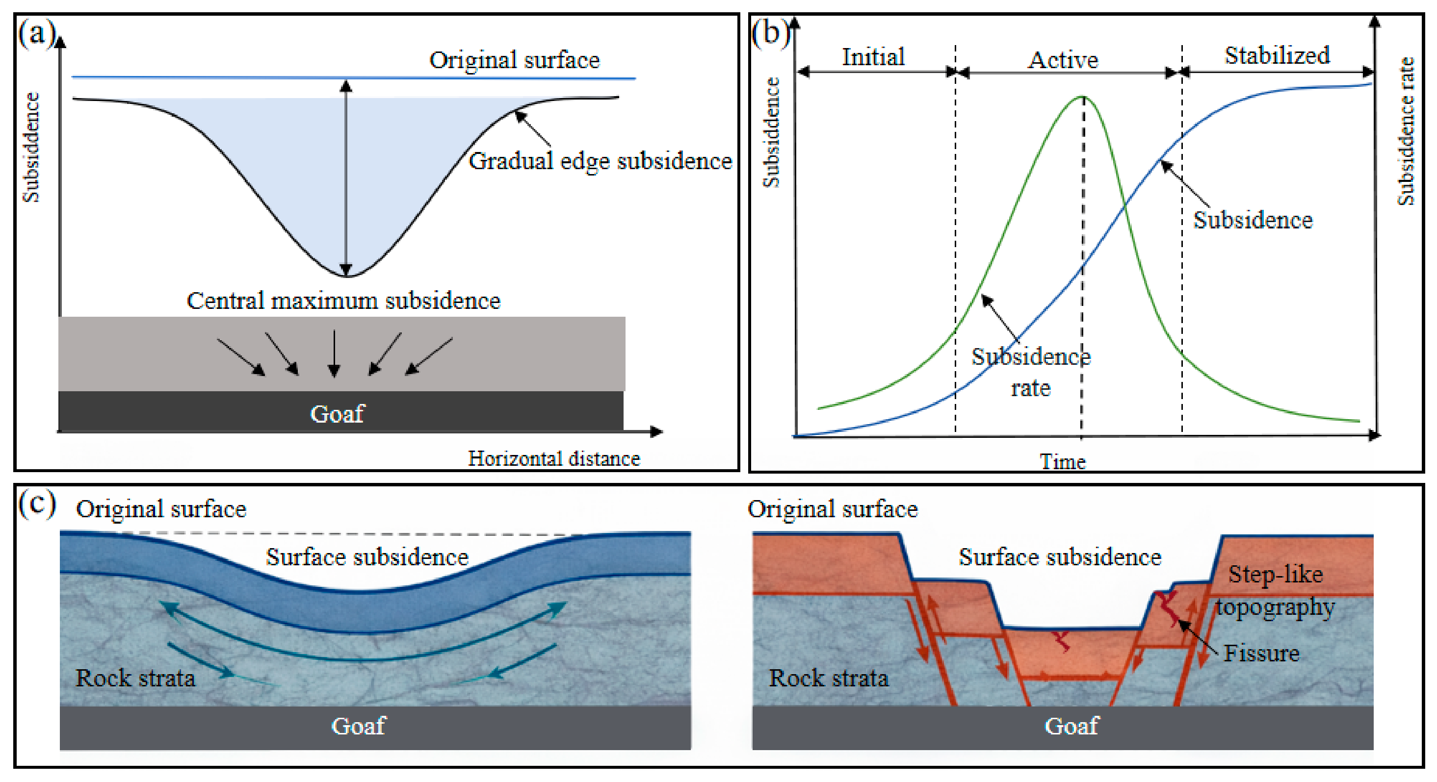
Surface Subsidence
Ground Fissure
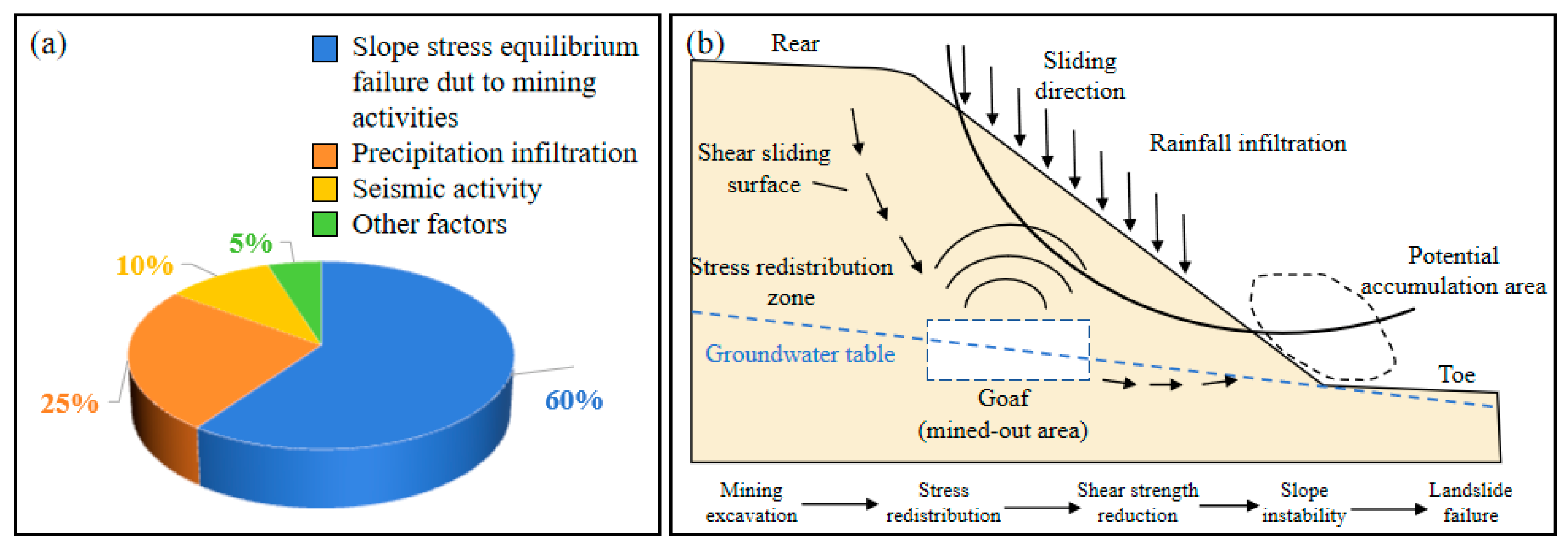
Landslide
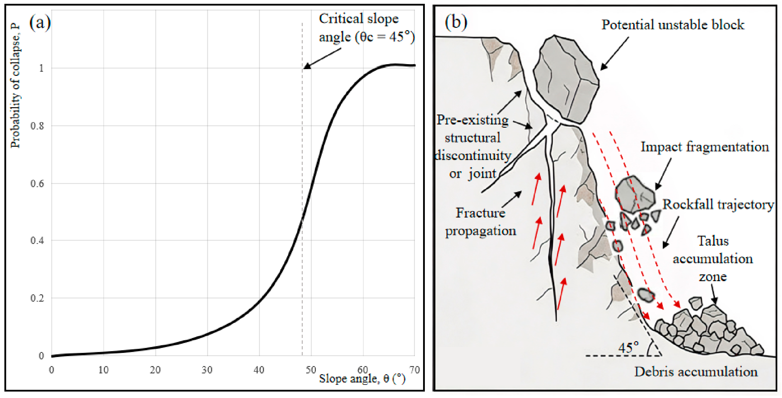
Collapse
Sinkholes
2.1.2. Monitoring Requirements for Different Geological Hazards
2.2. Monitoring Methodology Systems
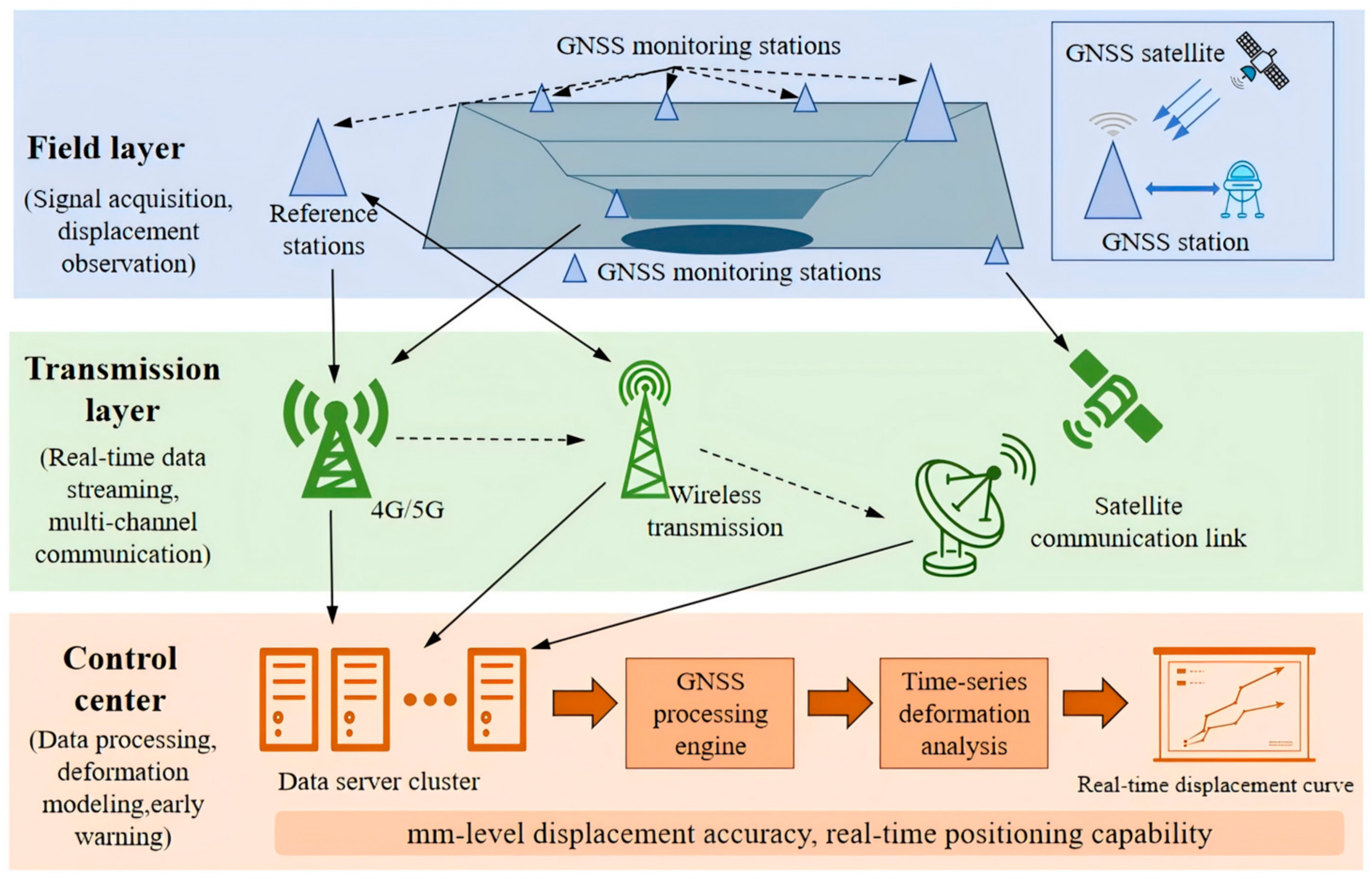
2.2.1. Ground-Based Monitoring Technologies
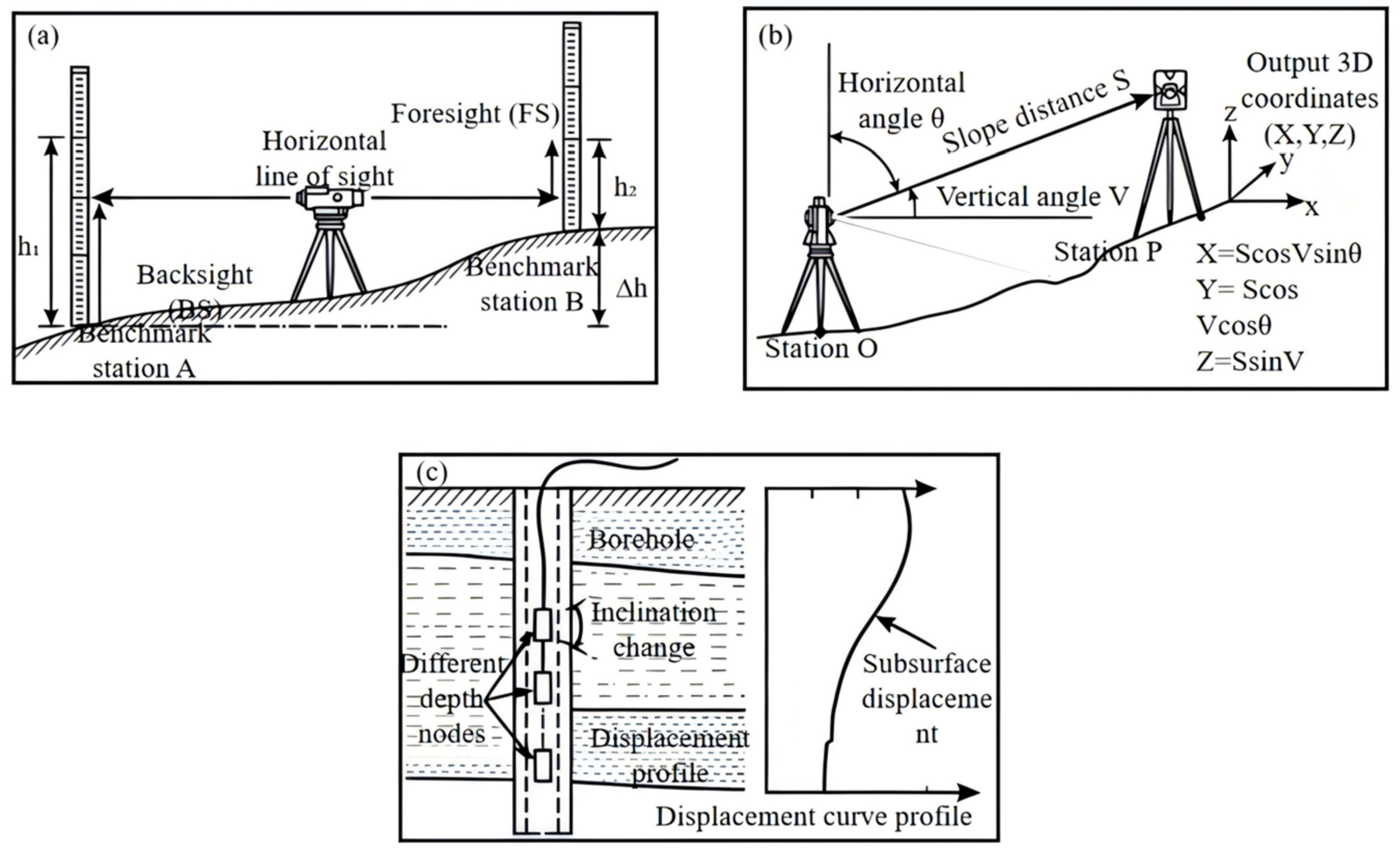
Traditional Geodetic Monitoring
Automated Sensing Networks
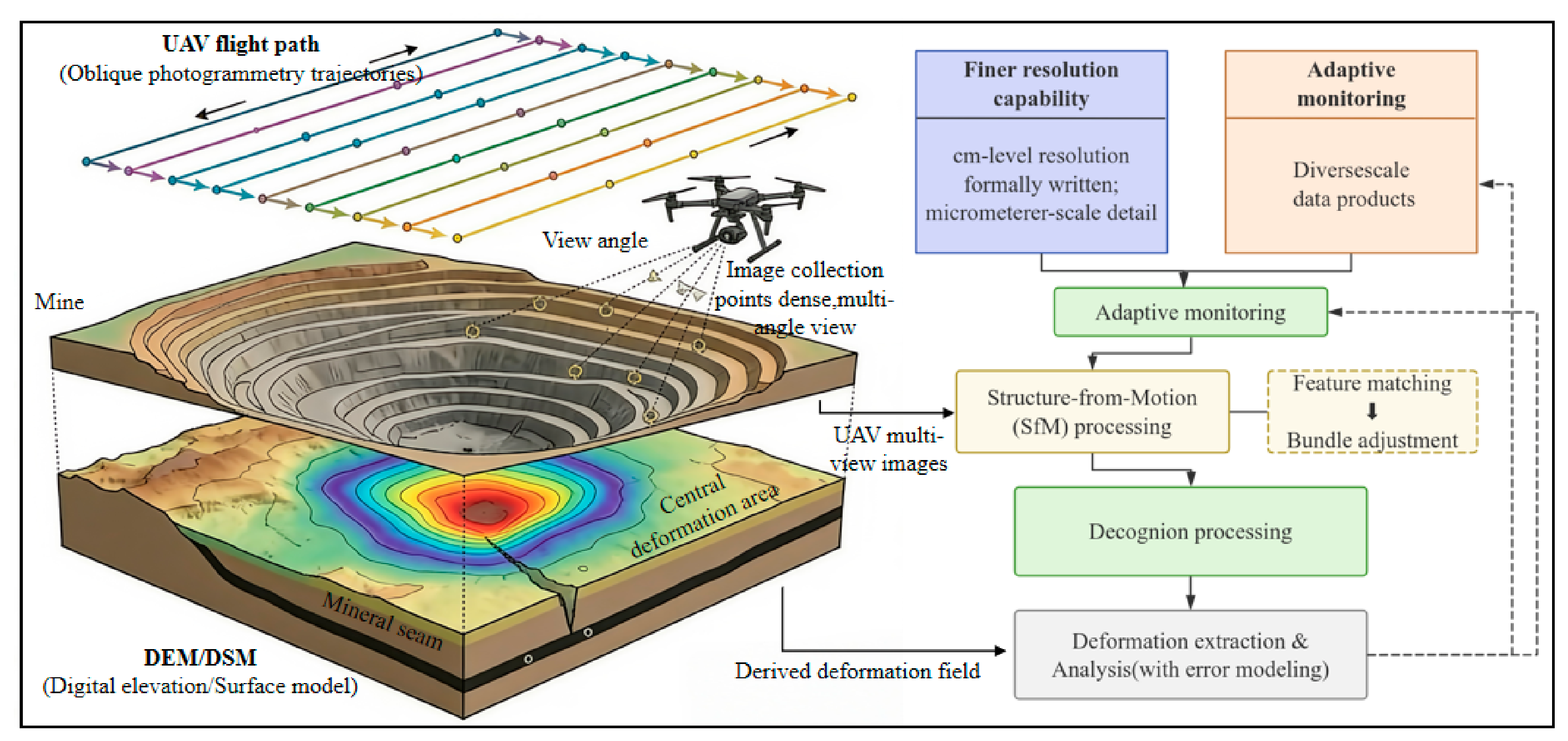
2.2.2. Aerial Monitoring Technology
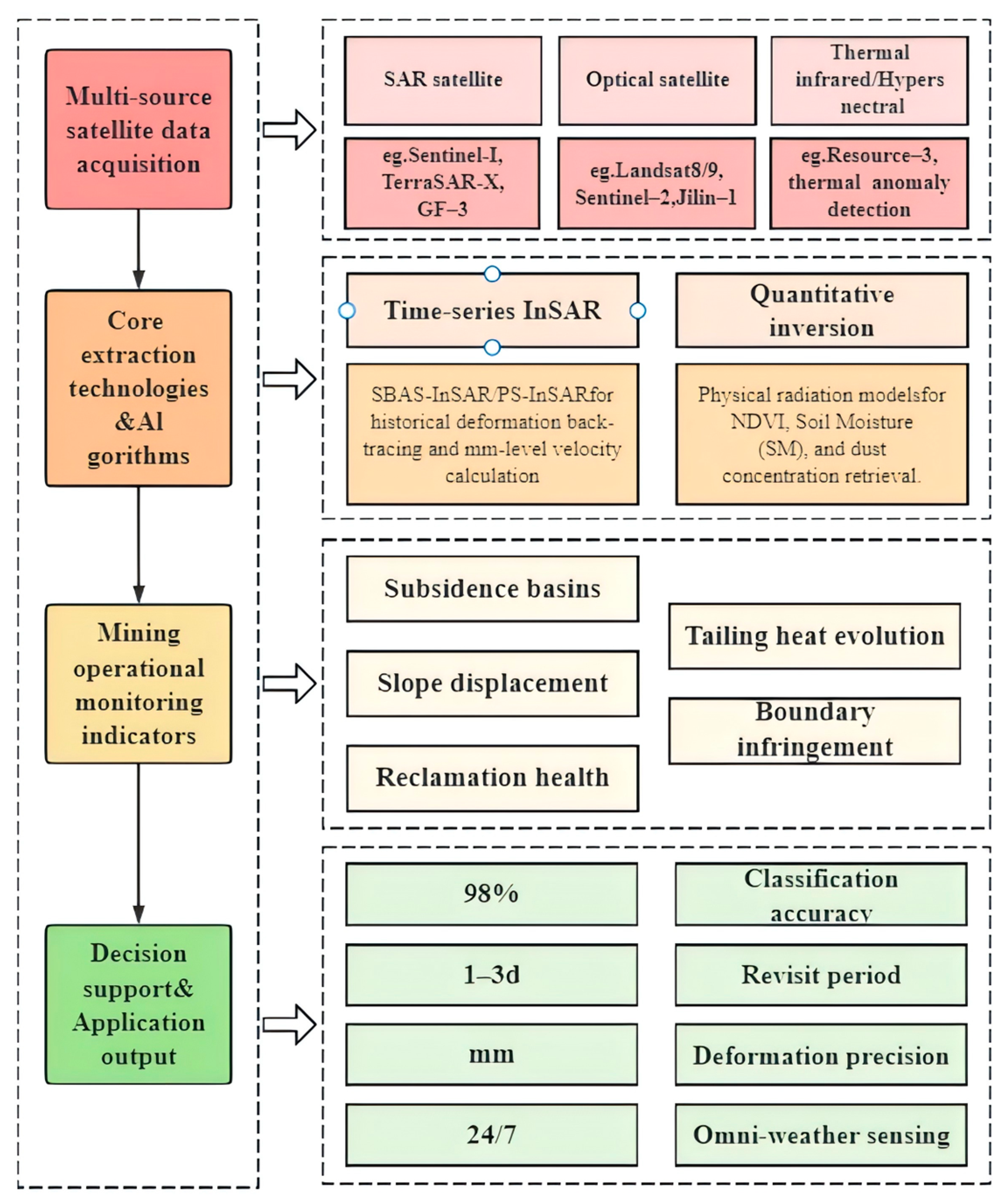
2.2.3. Spaceborne Monitoring Technology
Optical Remote Sensing
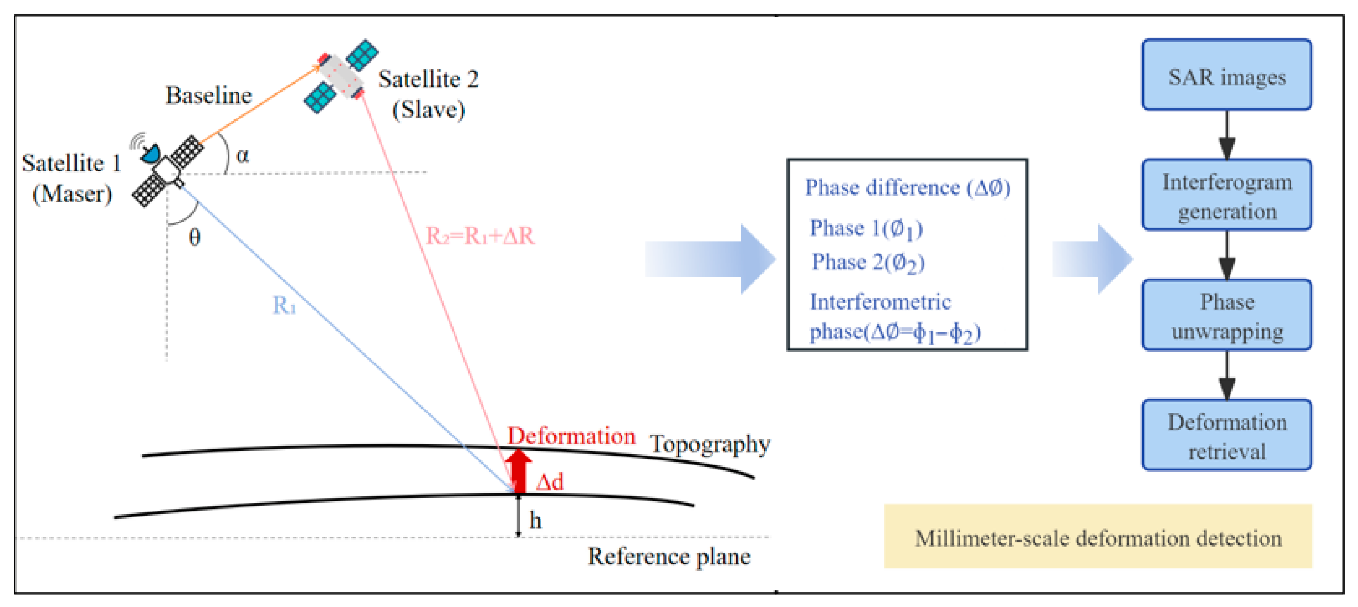
InSAR
Thermal Infrared (TIR) Remote Sensing
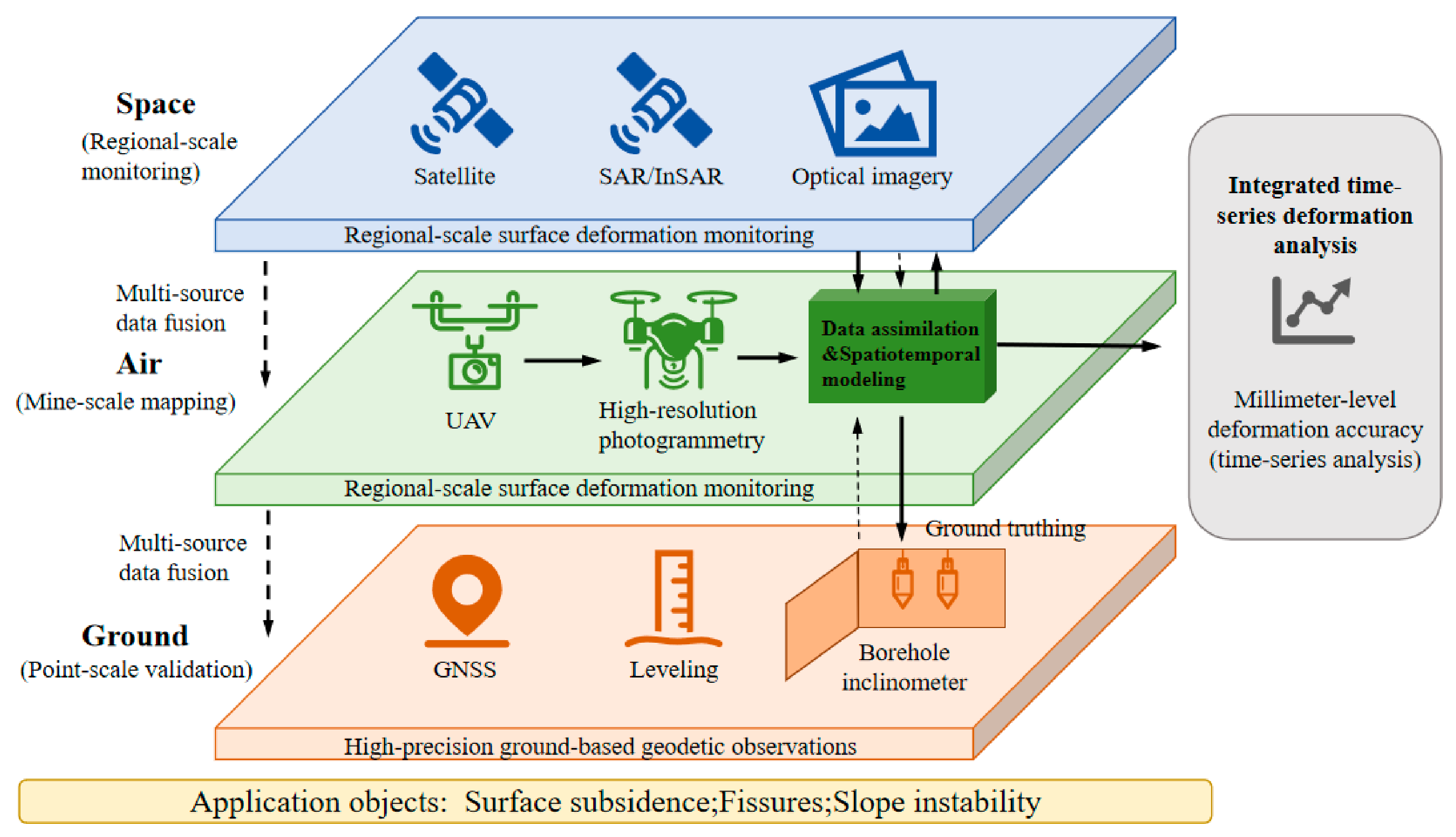
2.2.4. Multi-Source Remote Sensing Data Fusion
2.2.5. Emerging Technologies
DFOS
LiDAR Technology
Microseismical Monitoring
Deep Learning and Machine Learning
2.2.6. Specific Monitoring Strategies for Sinkholes and Dissolution Hazards
2.2.7. Technical Comparison
3. Results and Analysis
3.1. Application Cases
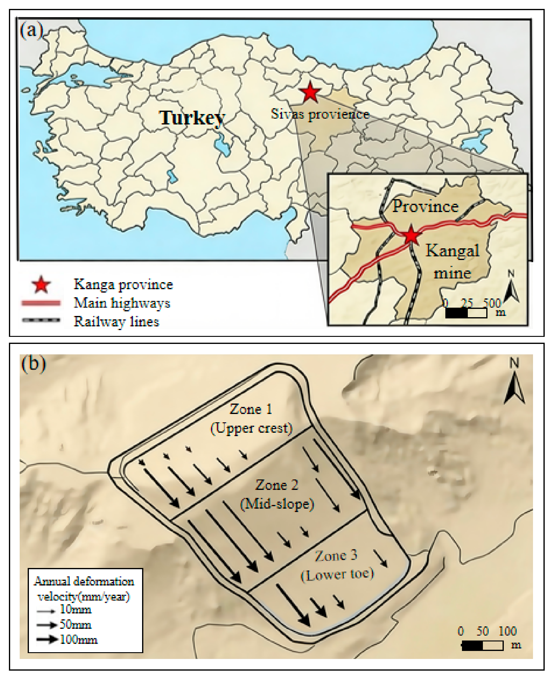
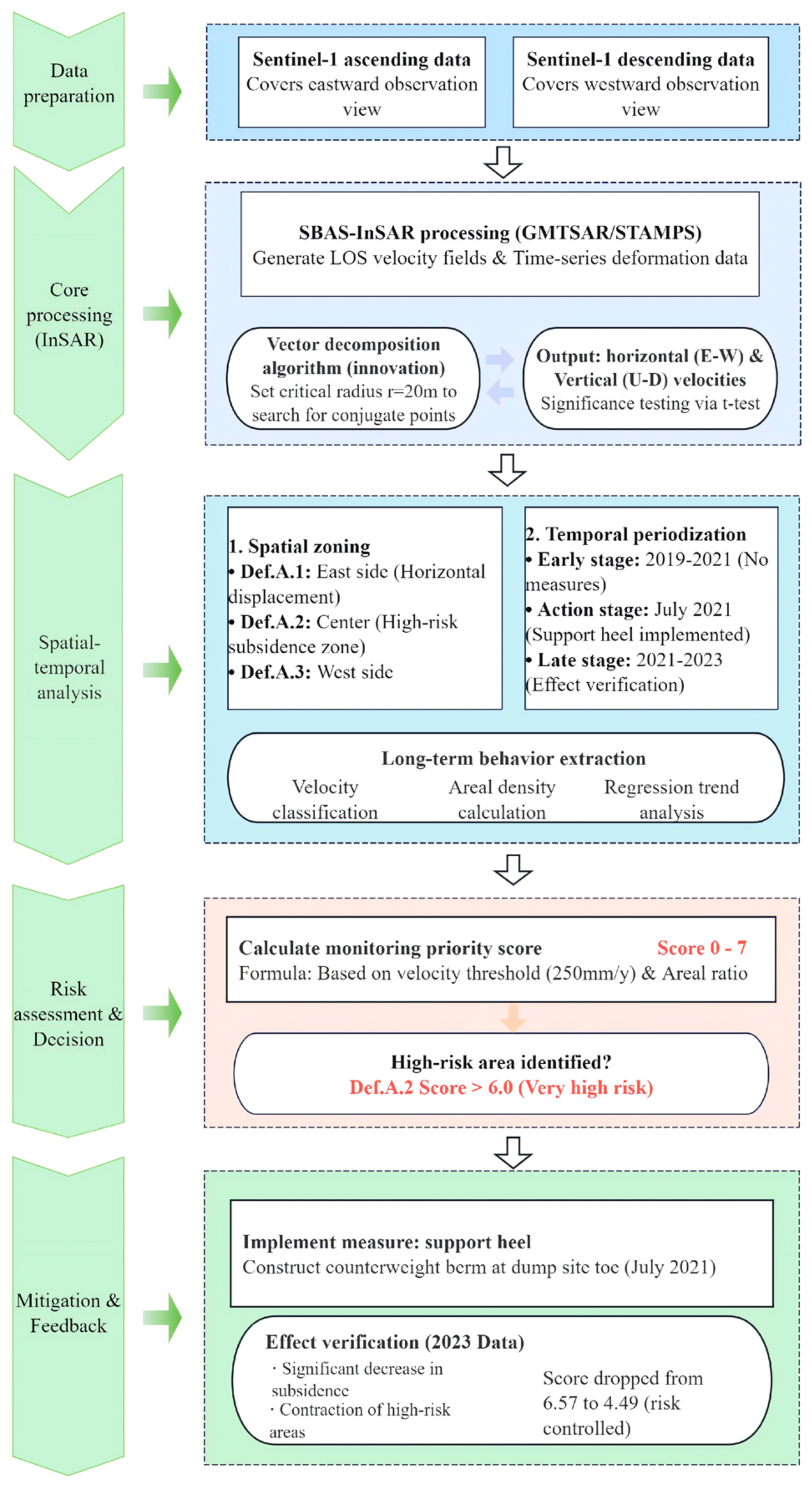
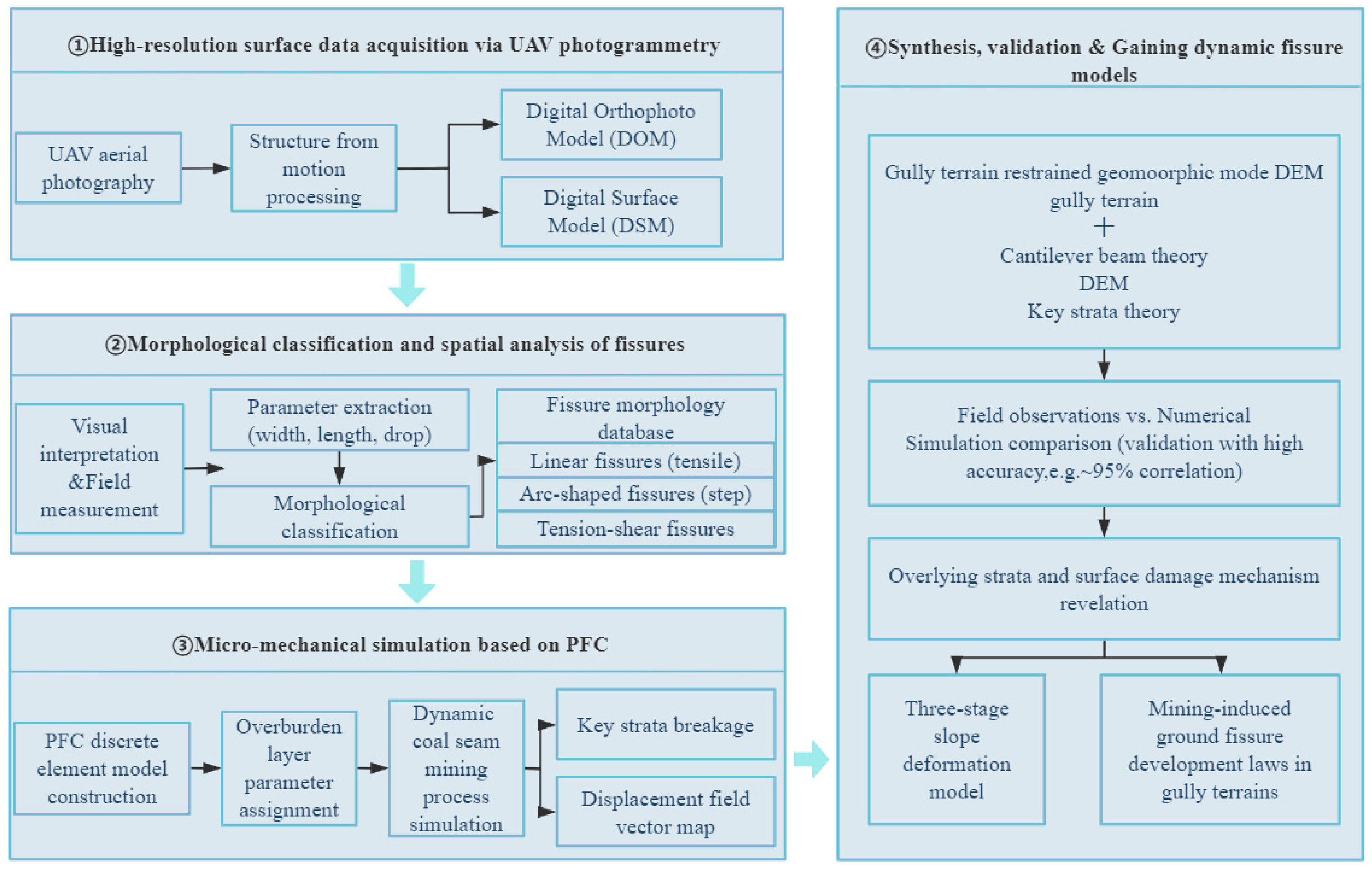
3.1.1. Case Study I
3.1.2. Case Study II
4. Discussion
4.1. Current Challenges and Future Perspectives
4.1.1. Current Challenges
4.1.2. Future Perspectives
5. Conclusions
Author Contributions
Funding
Data Availability Statement
Conflicts of Interest
References
- Herrera-García, G.; Ezquerro, P.; Tomas, R.; Bejar-Pizarro, M.; Lopez-Vinielles, J.; Rossi, M.; Mateos, R.M.; Carreon-Freyre, D.; Lambert, J.; Teatini, P. Mapping the global threat of land subsidence. Science 2021, 371, 34–36. [Google Scholar] [CrossRef] [Scilit] [PubMed]
- Tang, J.Y.; Sui, L.C.; Ma, T.; Dan, Y.; Yang, Q.; Zhao, R.F.; Qiang, X.H. GEE-based ecological environment variation analysis under human projects in typical China loess plateau region. Appl. Sci. 2023, 13, 4663. [Google Scholar] [CrossRef] [Scilit]
- Du, Z.; Ge, L.; Ng, A.H.M.; Lian, X.; Zhu, Q.; Horgan, F.G.; Zhang, Q. Analysis of the impact of the South-to-North water diversion project on water balance and land subsidence in Beijing, China between 2007 and 2020. J. Hydrol. 2021, 603, 126990. [Google Scholar] [CrossRef] [Scilit]
- Zhang, J.Y.; Wang, K.; Zhao, T.B.; Fang, P.; Qi, K.; Wei, B.W.; Li, Z.Y. Status and development of UAV remote sensing technology in mining surface subsidence and fracture measuring. Coal Sci. Technol. 2024, 52, 435–444. [Google Scholar]
- Fan, L.M.; Ma, X.D.; Li, Y.H.; Li, C.; Yao, C.W.; Xiang, M.X.; Wu, B.Y.; Peng, J. Geological disasters and control technology in high intensity mining area of western China. J. China Coal Soc. 2017, 42, 276–285. [Google Scholar]
- Pei, Y.; Qiu, H.; Yang, D.; Liu, Z.; Ma, S.; Li, J.; Cao, M.; Wufuer, W. Increasing landslide activity in the taxkorgan river basin (Eastern Pamirs Plateau, China) driven by climate change. Catena 2023, 223, 106911. [Google Scholar] [CrossRef] [Scilit]
- Kopeć, A.; Bugajska, N.; Milczarek, W.; Głazbicki, D. Long-term monitoring of the impact of the impact of mining operations on the ground surface at the regional scale based on the InSAR-SBAS technique, the Upper Silesian Coal Basin (Poland). Acta Geodyn. Geomater. 2022, 19, 93–110. [Google Scholar]
- Li, Y.; Zuo, X.; Xiong, P.; You, H.; Zhang, H.; Yang, F.; Zhao, Y.; Yang, Y.; Liu, Y. Deformation monitoring and analysis of Kunyang phosphate mine fusion with InSAR and GPS measurements. Adv. Space Res. 2022, 69, 2637–2658. [Google Scholar] [CrossRef] [Scilit]
- Yan, H.N.; Dai, W.J.; Lei, X.; Xu, W.B. Fusion of GNSS and InSAR time series using the improved STRE model: Applications to the San Francisco Bay Area and Southern California. J. Geod. 2022, 47, 4–20. [Google Scholar] [CrossRef] [Scilit]
- Zhou, C.; Lan, H.; Gong, H.; Zhang, Y.; Warner, T.A.; Clague, J.J.; Wu, Y. Reduced rate of land subsidence since 2016 in Beijing, China: Evidence from Tomo-PSInSAR using Radarsat-2 and Sentinel-1 datasets. Int. J. Remote Sens. 2020, 41, 1259–1285. [Google Scholar] [CrossRef] [Scilit]
- Li, R.H.; Zhao, Z.; Duan, M.Y.; Wang, Z.Y.; Wang, P. An analysis of surface subsidence in Chiba using PSInSAR technique. Int. Arch. Photogramm. Remote Sens. Spat. Inf. Sci. 2015, 40, 81–85. [Google Scholar] [CrossRef] [Scilit]
- Alimpika, G.; Girish, C.K.; Atul, K.P. Ground subsidence monitoring in India using InSAR: A review of current status and future prospects. Geosyst. Geoenviron. 2025, in press. [Google Scholar]
- Haghighi, M.H.; Motagh, M. Ground surface response to continuous compaction of aquifer system in Tehran, Iran: Results from a long-term multi-sensor InSAR analysis. Remote Sens. Environ. 2018, 221, 534–550. [Google Scholar] [CrossRef] [Scilit]
- Hanne, D.; White, N.; Lonergan, L. Subsidence analyses from the Betic Cordillera, southeast Spain. Basin Res. 2003, 15, 1–21. [Google Scholar] [CrossRef] [Scilit]
- Cigna, F.; Tapete, D. Present-day land subsidence rates, surface faulting hazard and risk in Mexico City with 2014–2020 Sentinel-1 IW InSAR. Remote Sens. Environ. 2021, 253, 112161. [Google Scholar] [CrossRef] [Scilit]
- Hastaoglu, K.O. Comparing the results of PSInSAR and GNSS on slow motion landslides, Koyulhisar, Turkey. Geomat. Nat. Hazards Risk 2016, 7, 786–803. [Google Scholar] [CrossRef] [Scilit]
- Poyraz, F.; Gül, Y.; Duymaz, B. Determination of deformations by using the PSI technique at a common dump site of three different open-pit marble mines in Turkey. Turkish J. Earth Sci. 2020, 29, 1004–1016. [Google Scholar] [CrossRef] [Scilit]
- Huang, D.M.; Zhang, C.; Yao, X.J.; Yang, X.H.; Liu, J. Research Progress of Mine Environment Remote Sensing Monitoring. Remote Sens. Technol. Appl. 2022, 37, 1043–1055. [Google Scholar]
- He, Y.L.; Liu, J.; Ma, F.S.; Li, G.; Guo, J. Analysis on the Characteristics and Causes of Ground Subsidence in Sanshandao Gold Mine. Gold Sci. Technol. 2023, 31, 605–612. [Google Scholar]
- Yang, D.; Qiu, H.; Ma, S.; Liu, Z.; Du, C.; Zhu, Y.; Cao, M. Slow surface subsidence and its impact on shallow loess landslides in a coal mining area. Catena 2022, 209, 105830. [Google Scholar] [CrossRef] [Scilit]
- Yu, J.Y.; Cao, J.C.; Wang, Y.; Liu, Y.H.; Liu, S.; Wang, L.F.; Wang, Z.Q. Monitoring of surface subsidence disasters and evolution laws caused by multiple mining activities in coal mines based on SBAS-InSAR. Geohazard Mech. 2025, 3, 286–296. [Google Scholar] [CrossRef] [Scilit]
- Li, X.B.; Li, Q.S.; He, F.L.; Zhang, C.; Han, P.H.; Zhang, Y.; Ren, Z.P.; Zhang, C.J.; Wu, Y. Formation and evolution law of high-intensity mining ground fissures and damage reduction method. J. China Coal Soc. 2024, 49, 518–529. [Google Scholar]
- Wu, K.; Li, L.; Wang, X.L.; Zhang, L.G.; Wang, Z.S.; Sun, X.M. Research of ground cracks caused by fully mechanized sublevel caving mining based on field survey. Procedia Earth Planet. Sci. 2009, 1, 1095–1100. [Google Scholar] [CrossRef] [Scilit]
- Zhao, K.Y. Prediction of the Distribution Laws of Surface Cracks and Water—Conducting Cracks Induced by Underground Coal Mining. Ph.D. Thesis, China University of Geosciences (Beijing), Beijing, China, 2016. [Google Scholar]
- Chen, Y.; Zhang, J.; Zhou, A.; Yin, B. Modeling and analysis of mining subsidence disaster chains based on stochastic petri nets. Nat. Hazards 2018, 92, 19–41. [Google Scholar] [CrossRef] [Scilit]
- Li, Y.X.; Lv, G.; Shao, H.B.; Dai, Q.H.; Du, X.P.; Liang, D.; Kuang, S.P.; Wang, D.H. Determining the influencing factors of preferential flow in ground fissures for coal mine dump eco-engineering. PeerJ 2021, 9, e10547. [Google Scholar] [CrossRef] [Scilit]
- Froude, M.J.; Petley, D.N. Global fatal landslide occurrence from 2004 to 2016. Nat. Hazard. Earth Syst. Sci. 2018, 18, 2161–2181. [Google Scholar] [CrossRef] [Scilit]
- Jiao, R.; Wang, S.; Yang, H.; Guo, X.; Han, J.; Pei, X.; Yan, C. Comprehensive remote sensing technology for monitoring landslide hazards and disaster chain in the Xishan Mining Area of Beijing. Remote Sens. 2022, 14, 4695. [Google Scholar] [CrossRef] [Scilit]
- Zhao, C.; Qin, H.L.; Zhu, Y.H.; Huang, R.C.; Wu, B.; He, C.T.; Xu, A.Q. Characteristics and causal mechanism analysis of geological hazards induced by underground mining in the Longtan formation coal mine group in Guizhou. Chin. J. Geol. Hazard Control 2025, 36, 182–190. [Google Scholar]
- Ayalew, L.; Yamagishi, H. The application of GIS-based logistic regression for landslide susceptibility mapping in the Kakuda-Yahiko Mountains Central Japan. Geomorphology 2005, 65, 15–31. [Google Scholar] [CrossRef] [Scilit]
- Marchelli, M.; Peila, D.; Giacomini, A. Rockfall in open pit mines: Management of the pit geometry and protection measures design. Int. J. Rock Mech. Min. Sci. 2023, 170, 105551. [Google Scholar] [CrossRef] [Scilit]
- Senanayake, I.P.; Hartmann, P.; Giacomini, A.; Huang, J.; Thoeni, K. Prediction of rockfall hazard in open pit mines using a regression based machine learning model. Int. J. Rock Mech. Min. Sci. 2024, 177, 105727. [Google Scholar] [CrossRef] [Scilit]
- Ma, X.F.; Zhang, S.C.; Hui, W.H.; Xu, X. InSAR based large scale detection and monitoring of the surface deformation in Linfen mining areas, Shanxi Province. Remote Sens. Nat. Resour. 2022, 34, 146–153. [Google Scholar]
- Liu, Z.H.; Peng, J.H.; Su, H.W.; Li, X.; Wang, C.Y.; Peng, Y. InSAR monitoring of large gradient deformation in coalfield and phase unwrapping research. Geod. Geodyn. 2026, 17, 130–144. [Google Scholar] [CrossRef] [Scilit]
- Chen, S.; Ma, M.; Ma, Y.; Feng, X.; Xu, G.; Li, H.; He, Y. Three-dimensional deformation monitoring of San Francisco Bay based on GNSS-InSAR data. Adv. Space Res. 2024, 75, 451–464. [Google Scholar] [CrossRef] [Scilit]
- Ren, Y.W.; Yuan, Q.; Chen, J.; Wang, Z.; Zhang, D.D.; Li, S.J. Evolution characteristics of mining-induced fractures in overburden strata under close-multi coal seams mining based on optical fiber monitoring. Eng. Geol. 2024, 343, 107802. [Google Scholar] [CrossRef] [Scilit]
- Kong, X.G.; Zhang, H.; Ma, Y.K.; Liu, T.; Zhao, P.X.; Muhammad, A.; He, D.; Zhao, A.H. Temporal-spatial laws of microseismic events induced by the fracture evolution of overburden strata and the relationship with gas emission during coal mining engineering. J. Appl. Geophys. 2025, 243, 105965. [Google Scholar] [CrossRef] [Scilit]
- Yang, Y.J.; Zhou, X.C.; He, Z.H.; Li, Z.L.; Cai, J.L.; Pei, P.; Liu, J.T.; Kuang, W. Multi-temporal digital twin method and application of landslide deformation monitoring: A case study on Baige landslide in Jinsha River. Hydrogeol. Eng. Geol. 2024, 51, 132–143. [Google Scholar]
- Kharisova, O.; Kharisov, T. Searching for possible precursors of mining-induced ground collapse using long-term geodetic monitoring data. Eng. Geol. 2021, 289, 106173. [Google Scholar] [CrossRef] [Scilit]
- Zhang, K.; Li, Q.S.; Dai, H.Y.; Guo, J.T.; Yan, Y.G. Research on integrated monitoring technology and practice of “space-sky-ground” on surface movement in mining area. Coal Sci. Technol. 2020, 48, 207–213. [Google Scholar]
- Zaczek-Peplinska, J.; Osińska-Skotak, K. Concrete surface evaluation based on the reflected TLS laser beam’s intensity image classification. Studia Geotech. 2018, 56–64. [Google Scholar] [CrossRef] [Scilit]
- Sztubecki, J.; Mrówczyńska, M. Vertical displacement monitoring using the modified leveling method. Measurement 2023, 206, 112264. [Google Scholar] [CrossRef] [Scilit]
- Ding, A.N.; Tian, B.L.; Li, K.Z.; Zhang, Q. Research of mining subsidence disaster monitoring. J. Henan Polytech. Univ. (Nat. Sci.) 2013, 32, 165–169. [Google Scholar]
- Bian, Z.F.; Zhang, Q.Z.; Tong, R.F.; Zhang, N.S.; Alex, P. Mine surveying science and technology for contemporary and future mining industries. Int. J. Min. Sci. Technol. 2026, 36, 251–275. [Google Scholar] [CrossRef] [Scilit]
- Zhao, S.; Li, D.H. Discussion on mountain deformation monitoring method based on coordinate difference. Geomat. Spat. Inf. Technol. 2012, 35, 222–224. [Google Scholar]
- Sha, L. Research and Application of New Method for Horizontal Displacement Monitoring of Deep Foundation Pit. J. Mine Surv. 2020, 48, 9–11. [Google Scholar]
- Stolecki, L.; Fuławka, K.; Osadczuk, T. On-line monitoring of underground workings stability with use of innovative inclinometric method-Case study from Polish copper mines. Tunn. Undergr. Space Technol. 2025, 164, 106796. [Google Scholar] [CrossRef] [Scilit]
- Shi, G.W.; Li, M.L.; Sun, C.H.; Ma, T.; Wang, W.F. Reliability study of flexible inclinometers in horizontal deformation monitoring and analysis of surrounding rock in large-scale underground chambers. Min. Technol. 2024, 24, 16–20. [Google Scholar]
- Pan, L.; Xiong, B.; Li, X.; Yu, W.; Dai, W. High-rate GNSS multi—Frequency uncombined PPP-AR for dynamic deformation monitoring. Adv. Space Res. 2023, 72, 4350–4363. [Google Scholar] [CrossRef] [Scilit]
- Bock, Y.; Melgar, D. Physical applications of GPS geodesy: A review. Rep. Prog. Phys. 2016, 79, 106801. [Google Scholar] [CrossRef] [Scilit]
- Wang, L.; Xu, H.; Shu, B.; Li, X.R.; Tian, Y.Q. Research progress and prospect of GNSS monitoring technology for Landslide Disasters. Navig. Position. Timing 2023, 10, 12–26. [Google Scholar]
- Chang, S.W.; Zou, J.G.; Yuan, X.B.; Zhang, H.B.; Zou, S.Z. The scheme and test of mine landslide antenna array deformation monitoring system. Geospat. Inf. 2007, 5, 100–103. [Google Scholar]
- Ahmed, W.A.; Isiaka, L.A.; Mala, B.; Olatoyinbo, S.F. Evolution of GNSS/GPS technology and its applications from ancient times to the present. Next Res. 2025, 2, 100387. [Google Scholar] [CrossRef] [Scilit]
- Han, J.Q. Research on High-precision GNSS Real-time Landslide Deformation Monitoring Technology and Environmental Modeling Analysis. Acta Geod. Cartogr. Sin. 2020, 49, 397. [Google Scholar]
- Tang, Z.G.; Cai, C.G.; Wang, Y.H.; Wei, G.Q.; Zhang, Z.; Jin, J.J. Monitoring and warning system for ground subsidence of gypsum mine based on fiber sensing. Chin. J. Geol. Hazard Control 2022, 33, 93–101. [Google Scholar]
- Zhang, L.; Ju, N.Q.; He, Z.Y.; Xie, M.L.; Zhang, C.Q.; Liu, Y. Real-time abnormal detection and analysis of time-series data of landslide crack meters. Chin. J. Rock Mech. Eng. 2023, 43, 206. [Google Scholar]
- Yang, C.; Su, X.; Gao, Z.; Kou, R. Rapid estimation of source parameters for the 2022 Mw 6.6 Menyuan earthquake with combined high-rate GNSS and strong motion data in Northeastern Tibet. Terr. Atmos. Ocean. Sci. 2024, 35, 21. [Google Scholar] [CrossRef] [Scilit]
- Xi, Y.; Hong, N.F. Multiple Imputation of Missing Monitoring Data in Wireless Sensor Networks Based on Random Forest. J. Sens. Actuators 2026, 39, 180–186. [Google Scholar]
- Sreedharan, S.; Ramachandran, M.; Ramesh, D. Harnessing digital twins and industrial-IoT for cutting-edge mining automation: A methodological and technology assessment prototype. Comput. Ind. Eng. 2025, 201, 110871. [Google Scholar] [CrossRef] [Scilit]
- Falabella, F.; Pepe, A.; Östir, K.; Gubaidullina, R.; Trajkovski, K.K.; Grigillo, D.; Grabrovec, V.; Hamza, V.; Preseren, P.P.; Blaha, H.; et al. Utilization of multi-sensor remote sensing technologies for open pit mine monitoring. Int. J. Appl. Earth Obs. Geoinf. 2025, 143, 104834. [Google Scholar] [CrossRef] [Scilit]
- Zhu, Y.H.; Yan, Y.G.; Dai, A.J.; Dai, H.Y.; Zhang, Y.J.; Zhang, W.Q.; Wang, Z.H.; Li, J.Y. UAV-MSSH: A novel UAV photogrammetry-based framework for mining surface three-dimensional movement basin monitoring. Measurement 2025, 242, 115944. [Google Scholar] [CrossRef] [Scilit]
- Li, J.; Peng, S.P.; Zhang, C.Y.; Yang, F.; Sang, X. Quantitative remote sensing-based monitoring and evaluation of the ecological environment in mining areas: Technology framework and application. Min. Sci. Technol. 2022, 7, 9–25. [Google Scholar]
- Zhang, X.; Li, W.; Chen, L.; Yang, Z.Y.; Dou, B.C.; Li, Y.; Chen, H.M. Research progress and prospect of remote sensing extraction of elements in open-pit mining areas. Remote Sens. Nat. Resour. 2023, 35, 25–33. [Google Scholar]
- Ma, L.; Chen, Y.; Lin, N. Research on Mine Ecological Environment Monitoring Technology Based on Multi-source Remote Sensing Data: A Case Study in Northern Shaanxi Coal Base. Northwest. Geol. 2025, 58, 91–101. [Google Scholar]
- Feng, K.K.; Zhao, J.C.; Yi, X.Y.; Guo, C.X.; Li, S.Q.; Tang, X.F.; Zhao, Y.L.; Ding, Z.W. Characteristics and drivers of clustered landslides induced by extreme rainstorm on June 16 in Fujian-Guangdong-Jiangxi junction area. Earth Sci. 2025, 50, 4111–4124. [Google Scholar]
- Pour, A.B.; Zoheir, B.; Pradhan, B.; Hashim, M. Editorial for the special issue: Multispectral and hyperspectral remote sensing data for mineral exploration and environmental monitoring of mined areas. Remote Sens. 2021, 13, 519. [Google Scholar] [CrossRef] [Scilit]
- Gül, Y.; Hastaoglu, K.Ö.; Poyraz, F. A new methodology for determining the long-term behavior of earth surface deformations from InSAR results. Adv. Space Res. 2024, 75, 3521–3540. [Google Scholar] [CrossRef] [Scilit]
- Pawluszek-Filipiak, K.; Borkowski, A. Integration of DInSAR and SBAS Techniques to Determine Mining-Related Deformations using Sentinel-1 Data: The Case Study of Rydultowy Mine in Poland. Remote Sens. 2020, 12, 242. [Google Scholar] [CrossRef] [Scilit]
- Liu, X.Y.; Zhu, W.; Zhou, Y.X.; Zhan, J.W.; Wei, Z.X.; Wu, J.; Shang, H.X.; Du, C. Multi-Platform geodetic synergy of InSAR, UAV, optical, and HD-ERT constrains kinematic evolution of the Jungong landslide (Yellow River Basin). Int. J. Appl. Earth Obs. Geoinf. 2026, 146, 105082. [Google Scholar] [CrossRef] [Scilit]
- Karanam, V.; Motagh, M.; Garg, S.; Jain, K. Multi-sensor remote sensing analysis of coal fire induced land subsidence in Jharia Coalfields, Jharkhand, India. Int. J. Appl. Earth Obs. Geoinf. 2021, 102, 102439. [Google Scholar] [CrossRef] [Scilit]
- Jiang, L.; Lin, H.; Ma, J.; Kong, B.; Wang, Y. Potential of small-baseline SAR interferometry for monitoring land subsidence related to underground coal fires: Wuda (Northern China) case study. Remote Sens. Environ. 2011, 115, 257–268. [Google Scholar] [CrossRef] [Scilit]
- Sun, Y.; Liu, J.; Xue, Z.; Li, Q.; Fan, C.; Zhang, X. A critical review of distributed fiber optic sensing for real-time monitoring geologic CO2 sequestration. J. Nat. Gas Sci. Eng. 2021, 88, 103751. [Google Scholar] [CrossRef] [Scilit]
- Wang, B.J.; Li, K.; Shi, B.; Wei, G.Q. Simulation experiment for distributed fiber monitoring on deformation of soil slope. J. Eng. Geol. 2010, 18, 325–332. [Google Scholar]
- Liu, L.; Duda, M.I.; Salazar-Vásquez, A.F.; Berntsen, A.N. A review of fiber optic sensing in geomechanical applications at laboratory and field scales. Geomech. Energy Environ. 2025, 43, 100699. [Google Scholar] [CrossRef] [Scilit]
- Singh, S.K.; Banerjee, B.P.; Raval, S. A review of laser scanning for geological and geotechnical applications in underground mining. Int. J. Min. Sci. Technol. 2023, 33, 133–154. [Google Scholar] [CrossRef] [Scilit]
- Raval, S.; Banerjee, B.P.; Singh, S.K.; Canbulat, I. A preliminary investigation of mobile mapping technology for underground mining. In Proceedings of the IEEE International Geoscience and Remote Sensing Symposium, Yokohama, Japan, 28 July–2 August 2019; pp. 6071–6074. [Google Scholar]
- Ellmann, A.; Kütimets, K.; Varbla, S.; Väli, E.; Kanter, S. Advancements in underground mine surveys by using SLAM-enabled handheld laser scanners. Surv. Rev. 2022, 54, 363–374. [Google Scholar] [CrossRef] [Scilit]
- Merwe, J.W.; Andersen, D.C. Applications and benefits of 3D laser scanning for the mining industry. J. S. Afr. Inst. Min. Metall. 2013, 113, 213–219. [Google Scholar]
- Jiang, H.; Cheng, D.Q.; Yi, F.D.; Wang, P.; Cui, W.; Kou, Q.Q. Overview of research and applications of new generation information technologies in intelligent mines. J. Mine Autom. 2024, 50, 1–16. [Google Scholar]
- Cao, A.Y.; Li, M.T.; Yang, X.; Yang, Y.; Li, S.; Liu, Y.Q.; Wang, C.B. Construction and application of foundational models for intelligent processing of microseismic events in mines. J. China Coal Soc. 2025, 50, 2823–2836. [Google Scholar]
- Zhao, H.B.; Liu, R.; Liu, Y.H.; Zhang, Y.X.; Gu, T. Research on classification and identification of mine microseismic signals based on deep learning method. J. Min. Sci. Technol. 2022, 7, 166–174. [Google Scholar]
- Guo, Q.H. Development and application of precursor information perception technology for coal mine dynamic disasters. Coal Sci. Technol. 2022, 50, 76–83. [Google Scholar]
- Zhu, W.Q.; Biondi, E.; Li, J.X.; Yin, J.X.; Ross, Z.E.; Zhan, Z.W. Seismic Arrival-time Picking on Distributed Acoustic Sensing Data using Semi-supervised Learning. Nat. Commun. 2023, 14, 8192. [Google Scholar] [CrossRef] [Scilit]
- Zhang, Y.J.; Kong, J.Y.; Long, S.F.; Zhu, Y.H.; Zhu, W.X.; Wu, T.H. Study on the Ground Fissure Development Law of Coal Mining Based on UAV Photogrammetry and the Particle Flow Theory. Front. Environ. Sci. 2022, 10, 3389. [Google Scholar] [CrossRef] [Scilit]







| Disaster Type | Precision Requirements | Core Detection Indicators | Key Monitoring Objects | Examples of Monitoring Techniques |
|---|---|---|---|---|
| Surface subsidence | Vertical displacement: ±1–5 mm; Horizontal displacement: ±1–2 mm | Subsidence magnitude, subsidence rate, horizontal displacement, subsidence basin status | Ground surface above goaf | InSAR, GNSS, Precision leveling |
| Ground fissures | Width ≥ 0.1 mm; Length error ≤ 1% | Width, length, depth, density | Fissure development zones | UAV photogrammetry, LiDAR |
| Landslides | Displacement ≥ 1 mm; Strain ≥ 10 μℇ; Pore water pressure ≥ 1 kPa | 3D displacement, strain distribution, groundwater status, Factor of Safety (FoS) | Slope bodies, Dump sites | GNSS, Inclinometers, Rain gauges |
| Collapses | Displacement ≥ 0.5 mm; Vibration frequency: 1100 Hz | Displacement of unstable rock masses, vibration signals, stress state, meteorological conditions | Unstable rock masses | Terrestrial Laser Scanning (TLS), Microseismical monitoring |
| Sinkholes | Cavity detection resolution ≤ 0.5 m; Vertical displacement ≥ 1 mm | Underground cavity dimensions, groundwater level variations, soil moisture, surface micro-subsidence | Karst terrain, active dewatering zones, underground pipe networks | Ground Penetrating Radar (GPR), Groundwater wells, InSAR |
| InSAR Technique Type | Deformation Precision | Spatial Resolution | Temporal Resolution | Application Scenarios | Advantages | Limitations |
|---|---|---|---|---|---|---|
| D-InSAR | ±1–3 mm | 10–30 m | Dependent on satellite revisit cycles | Large-gradient deformation, short-term monitoring | Rapid data processing, low hardware requirements | Prone to decorrelation, highly sensitive to atmospheric delay |
| PS-InSAR | ±0.1–1 mm | 5–25 m | 12–35 days | Long-term slow deformation, urban areas, and mining districts | High precision, strong stability | Reliance on Persistent Scatterers (PS), massive data volume |
| SBAS-InSAR | ±0.5–2 mm | 10–20 m | 12–35 days | Large-scale deformation, integrated monitoring of mining areas | Strong resistance to decorrelation, capability for time-series analysis | Complex data processing, long processing cycles |
| Technology Type | Spectral Bands | Primary Applications | Advantages | Limitations |
|---|---|---|---|---|
| Optical remote sensing | Visible/ Near-Infrared/ Short-Wave Infrared | Land cover classification, mining area changes, vegetation health | Intuitive classification results, high spatial resolution | Limited by weather conditions and illumination |
| InSAR | Microwave | Surface subsidence, deformation monitoring | All-weather capability, high-precision deformation monitoring | Acquisition intervals dependent on satellite orbital revisit cycles |
| TIR remote sensing | 8–14 µm | Land surface temperature anomalies | Sensitive to nighttime observations and thermal anomalies | Lower spatial resolution than optical imagery |
| LiDAR Type | Point Cloud Density | Ranging Accuracy | Detection Threshold | Scanning Range | Spatial Resolution | Application Scenarios |
|---|---|---|---|---|---|---|
| TLS | 1000–10,000 pts/m2 | ±2 mm | 1–3 cm | 0.5–1000 m | Millimeter-level | Fine-scale slope modeling, monitoring of unstable rock masses |
| UAV-LiDAR | 50–500 pts/m2 | ±5 mm | 5–15 cm | 100–1000 m | Centimeter-level | Regional subsidence, monitoring of vegetation-covered areas |
| ALS | 1–10 pts/m2 | ±15 mm | 10–30 cm | 1–10 km | Decimeter-level | Large-scale topographic mapping, regional monitoring |
| Algorithm Category | Representative Algorithms | Application Scenarios | Accuracy | Data Requirements | Computational Complexity | Advantages |
|---|---|---|---|---|---|---|
| Machine learning | Support Vector Machine (SVM) | Hazard classification, fissure identification | 85–90% | Moderate (≥500 sets) | Moderate | Robust generalization, effective for small sample sizes |
| Random Forest (RF) | Parameter inversion, risk assessment | 88–92% | Moderate (≥800 sets) | Moderate | Strong anti-interference, resistant to overfitting | |
| Deep learning | Convolutional Neural Network (CNN) | Image recognition, fissure extraction | 90–95% | Large (≥1000 sets) | High | Powerful feature extraction, high recognition accuracy |
| Long Short-Term Memory (LSTM) | Time-series forecasting, deformation trends | 92–97% | Large (≥2000 sets) | High | Captures temporal dependencies, high predictive accuracy | |
| Fully Convolutional Network (FCN) | Semantic segmentation, hazard boundary delineation | 91–94% | Large (≥1500 sets) | High | Pixel-level segmentation, precise boundary identification |
| Monitoring Hierarchy | Technological Methods | Core Advantages | Limitations | Applicable Hazard Types |
|---|---|---|---|---|
| Ground-based monitoring | Traditional geodetic monitoring | Millimeter-level precision | High labor intensity for point-based surveys; restricted by terrain and weather | Subsidence pits, initial stages of landslide deformation |
| Automated sensing networks | 24/7 real-time dynamic monitoring; high automation | High node costs; vulnerable to damage from mining activities | Landslides, collapses, ground fissures | |
| Aerial monitoring | UAV | Highly flexible; superior spatial resolution | Limited flight endurance; low wind resistance; heavy data processing load | Extent of collapse deposits, overall landslide morphology |
| Spaceborne monitoring | Optical Remote Sensing | Extensive coverage; intuitive interpretation | Significant interference from clouds/fog; unable to penetrate vegetation | Large-scale environmental surveys of mining districts |
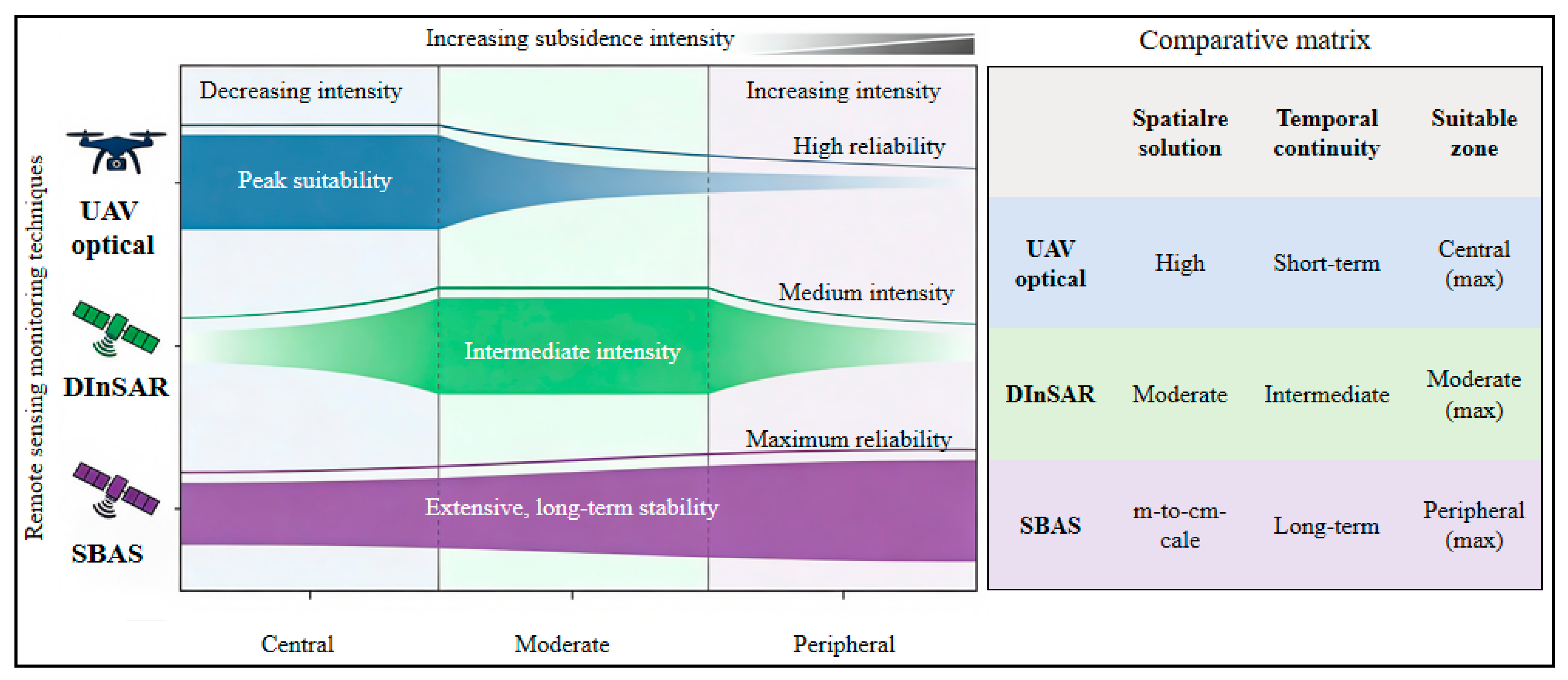
| InSAR | All-weather; large-scale; millimeter-level areal deformation precision | Limited by vegetation decorrelation and excessive deformation gradients | Ground subsidence basins in goaf areas, extremely slow landslides | |
| TIR remote sensing | High sensitivity to thermal anomalies | Low spatial resolution; susceptible to complex surface temperature noise | Coal seam self-ignition zones, abnormal groundwater seepage | |
| Multi-source remote sensing data fusion | Leverages multi-sensor synergies; balances wide coverage with high-res monitoring | Complex fusion algorithms; spatial-temporal discrepancies across sources | Surface subsidence, fissures, tailings dam deformation, waste dump stability | |
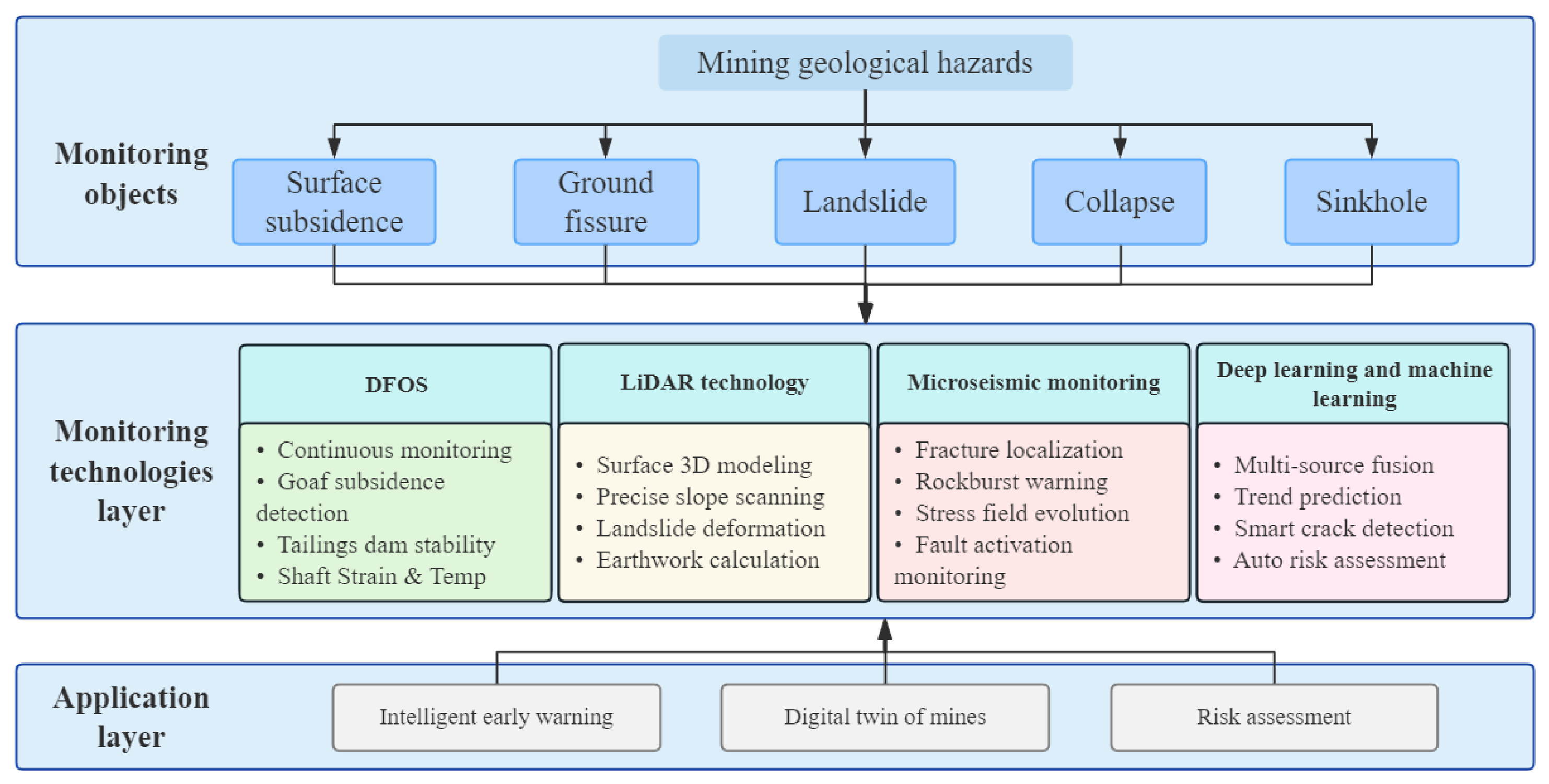
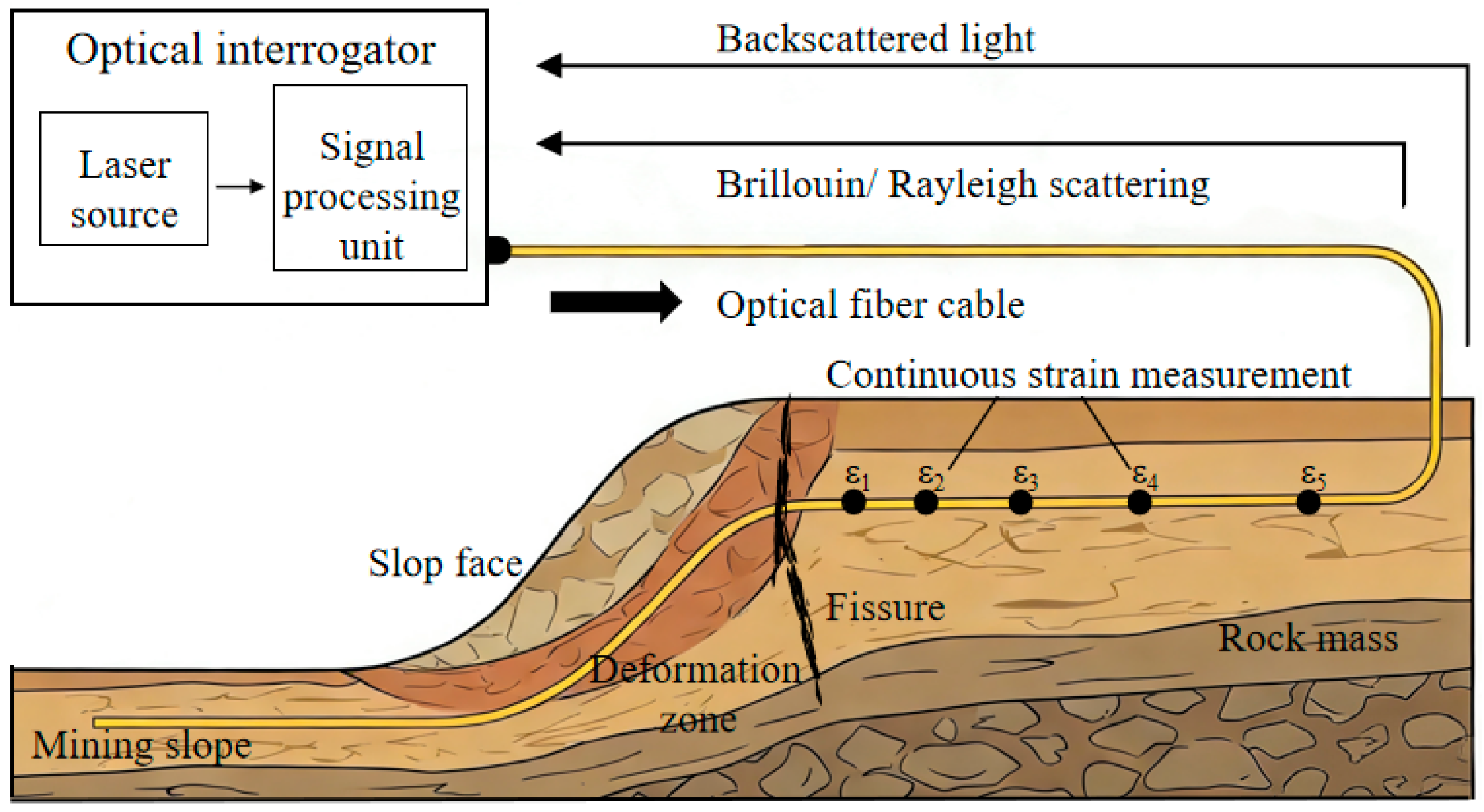
| Emerging technologies | DFOS | Multi-point sensing along a single cable; long-range; EMI-resistant | Strict installation requirements; expensive instrumentation | Mining-induced overburden failure, internal slope slips surfaces |
| LiDAR | Capable of canopy penetration; acquires high-precision 3D information | Costly hardware; complex point cloud processing | Potential landslide sites with dense vegetation cover | |
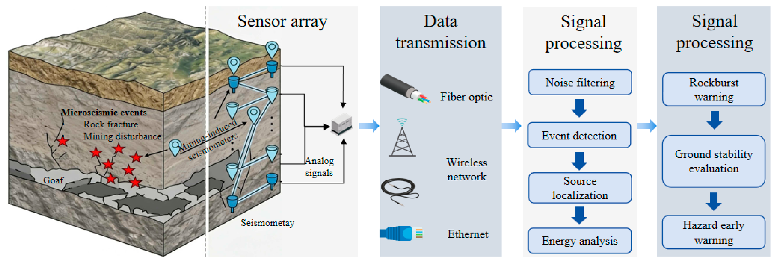
| Microseismical monitoring | 3D real-time localization and energy assessment of deep fractures | Sensitive to noise; highly dependent on velocity models | Mining-induced tremors, rock bursts, goaf collapses | |
| DL/ML | Powerful nonlinear fitting for massive heterogeneous datasets | requires large training datasets | Multi-source fusion for subsidence prediction; multimodal early warning | |
| Specific monitoring strategies for sinkholes and dissolution hazards | Highly targeted for karst features | Depth penetration limits; complex data interpretation | Sinkholes, dissolution hazards, karst collapses | |
Disclaimer/Publisher’s Note: The statements, opinions and data contained in all publications are solely those of the individual author(s) and contributor(s) and not of MDPI and/or the editor(s). MDPI and/or the editor(s) disclaim responsibility for any injury to people or property resulting from any ideas, methods, instructions or products referred to in the content. |
© 2026 by the authors. Licensee MDPI, Basel, Switzerland. This article is an open access article distributed under the terms and conditions of the Creative Commons Attribution (CC BY) license.
Share and Cite
Zhang, Y.; Sun, Y.; Yan, Y.; Wang, S.; Ge, L. Research Status, Challenges and Future Perspectives of Geological Hazard Monitoring Methods in Mining Areas. Remote Sens. 2026, 18, 1333. https://doi.org/10.3390/rs18091333
Zhang Y, Sun Y, Yan Y, Wang S, Ge L. Research Status, Challenges and Future Perspectives of Geological Hazard Monitoring Methods in Mining Areas. Remote Sensing. 2026; 18(9):1333. https://doi.org/10.3390/rs18091333
Chicago/Turabian StyleZhang, Yanjun, Yue Sun, Yueguan Yan, Shengliang Wang, and Lina Ge. 2026. "Research Status, Challenges and Future Perspectives of Geological Hazard Monitoring Methods in Mining Areas" Remote Sensing 18, no. 9: 1333. https://doi.org/10.3390/rs18091333
APA StyleZhang, Y., Sun, Y., Yan, Y., Wang, S., & Ge, L. (2026). Research Status, Challenges and Future Perspectives of Geological Hazard Monitoring Methods in Mining Areas. Remote Sensing, 18(9), 1333. https://doi.org/10.3390/rs18091333