Evaluating SAR-Derived Phenological Metrics for Monsoon (Kharif) Crop Monitoring in Diversified Agricultural Systems: Insights from Central India

Highlights
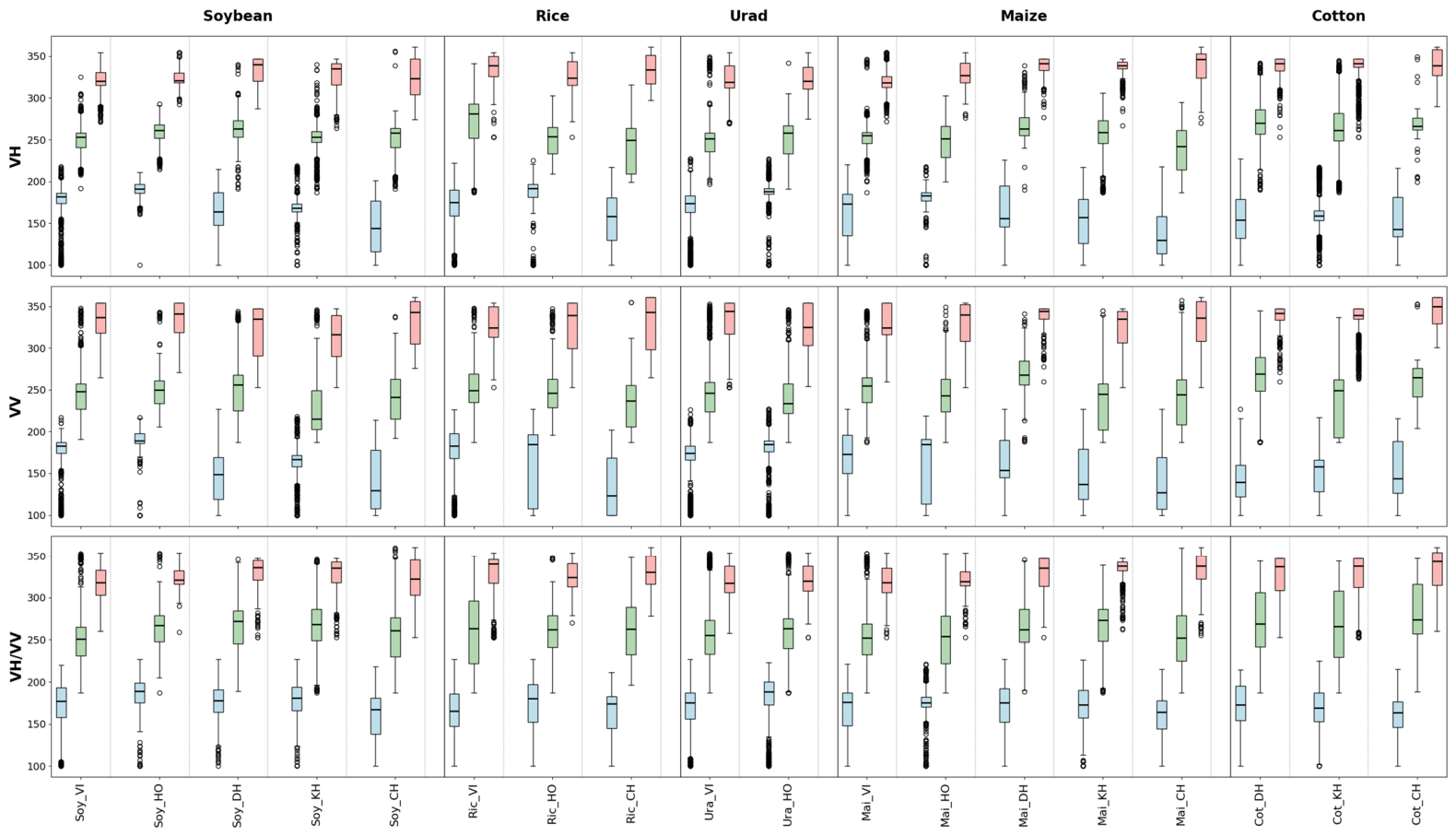
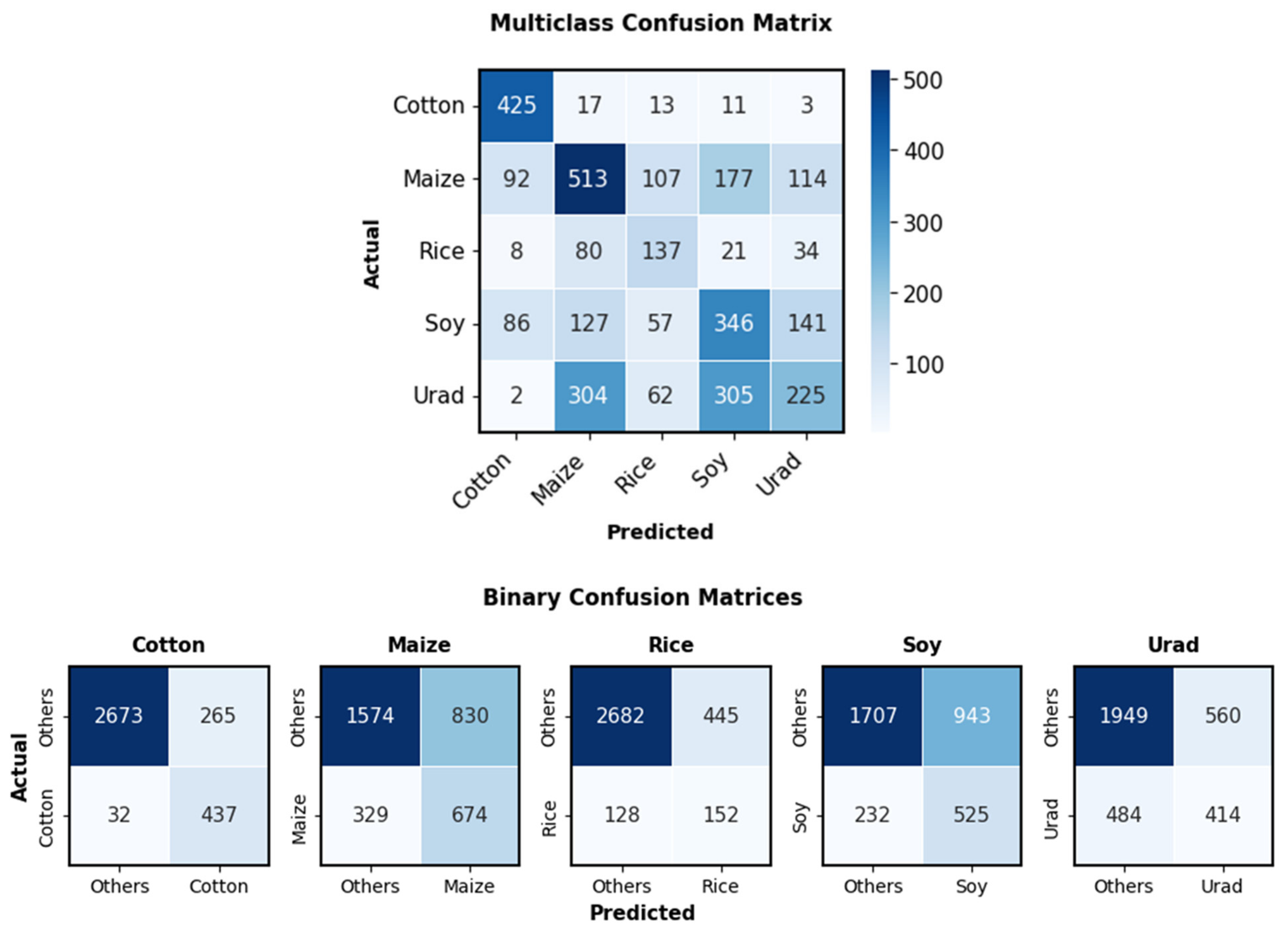
- Phenological convergence among monsoon-aligned cereal and legume crops represents a fundamental constraint on multi-crop discrimination using Sentinel-1 SAR alone. Cotton showed the most distinctive phenological signatures and highest classification performance, while rice demonstrated the strongest cross-district consistency; cereal–legume crops (soybean, urad, maize) exhibited substantial overlap due to shared monsoon-aligned phenology.
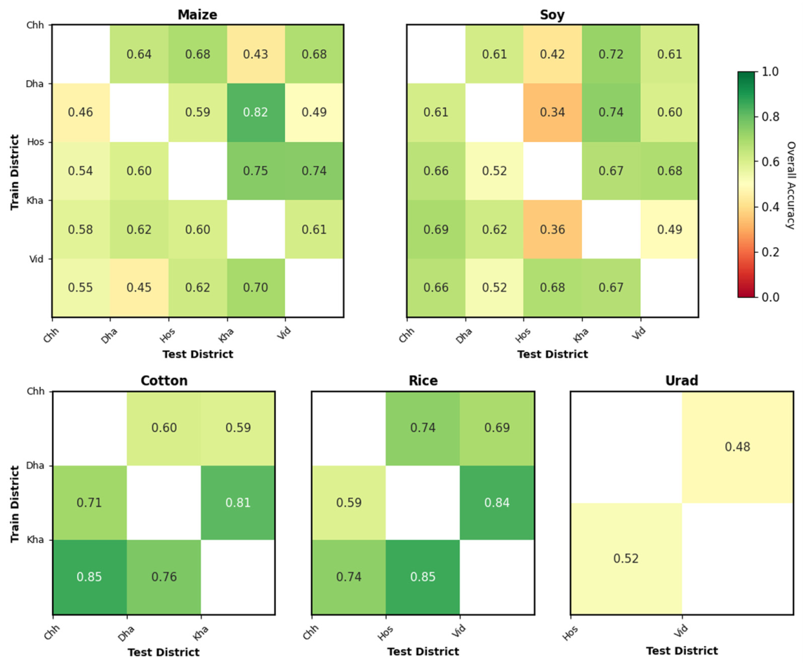
- Classification models showed good transferability in single/double-cropping districts but degraded substantially in intensive triple-cropping systems like those found in Hoshangabad, where compressed phenological windows and elevated baseline backscatter reduced metric reliability.
- Findings emphasize the need for multi-sensor or higher-resolution strategies to overcome cereal–legume separability limitations for monsoon crop mapping in smallholder systems.
- SAR phenological metrics should be applied cautiously in regions with intensive multi-cropping, where compressed fallow periods and residual biomass from adjacent crops obscure crop-specific signatures.
Abstract
1. Introduction
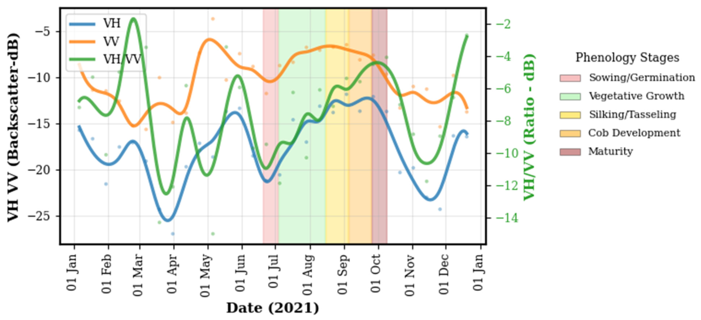
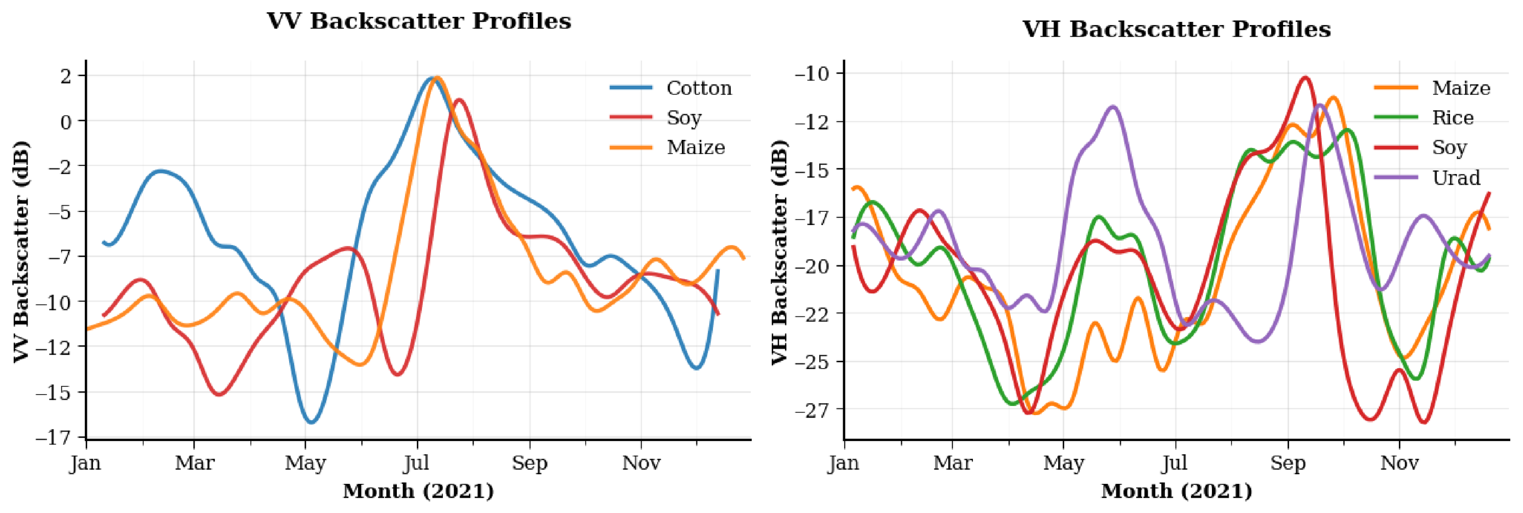
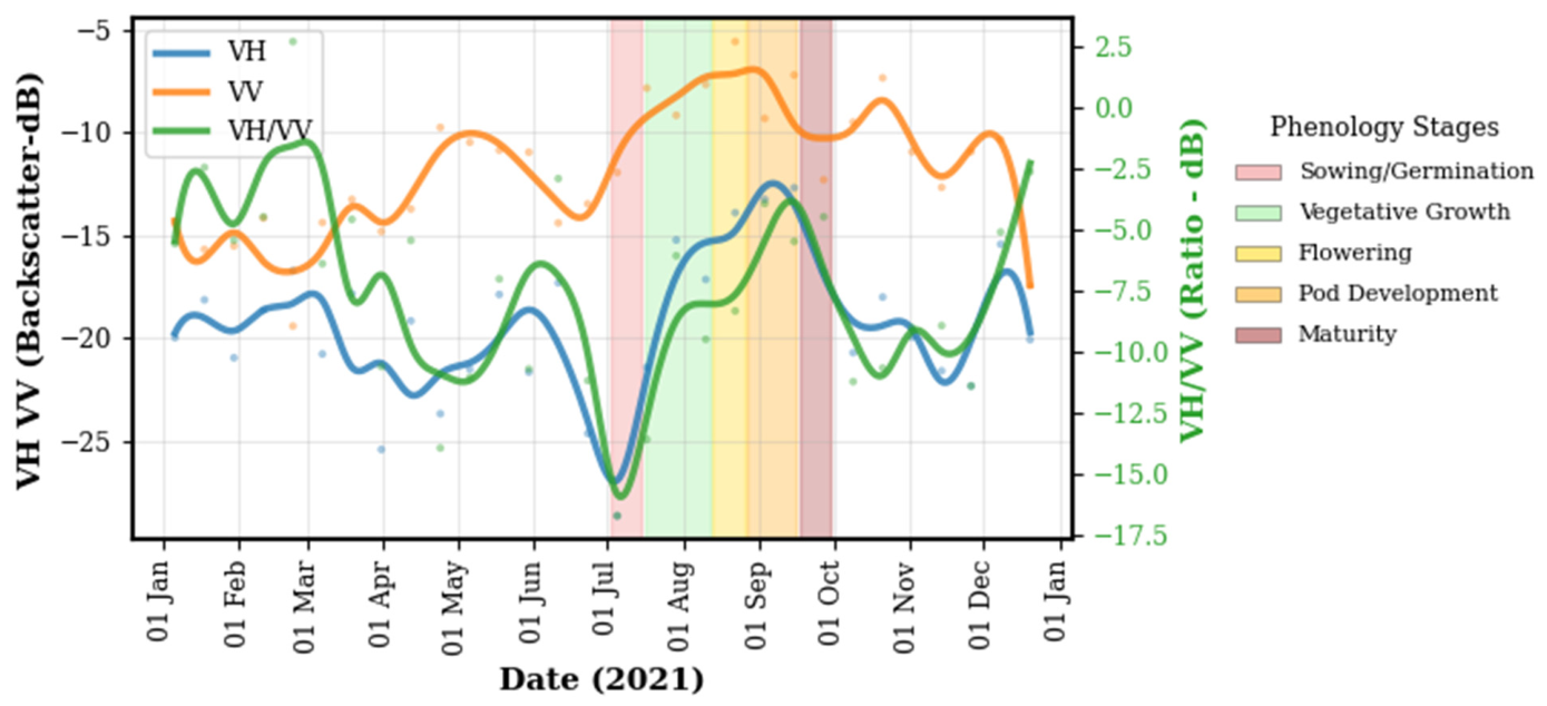
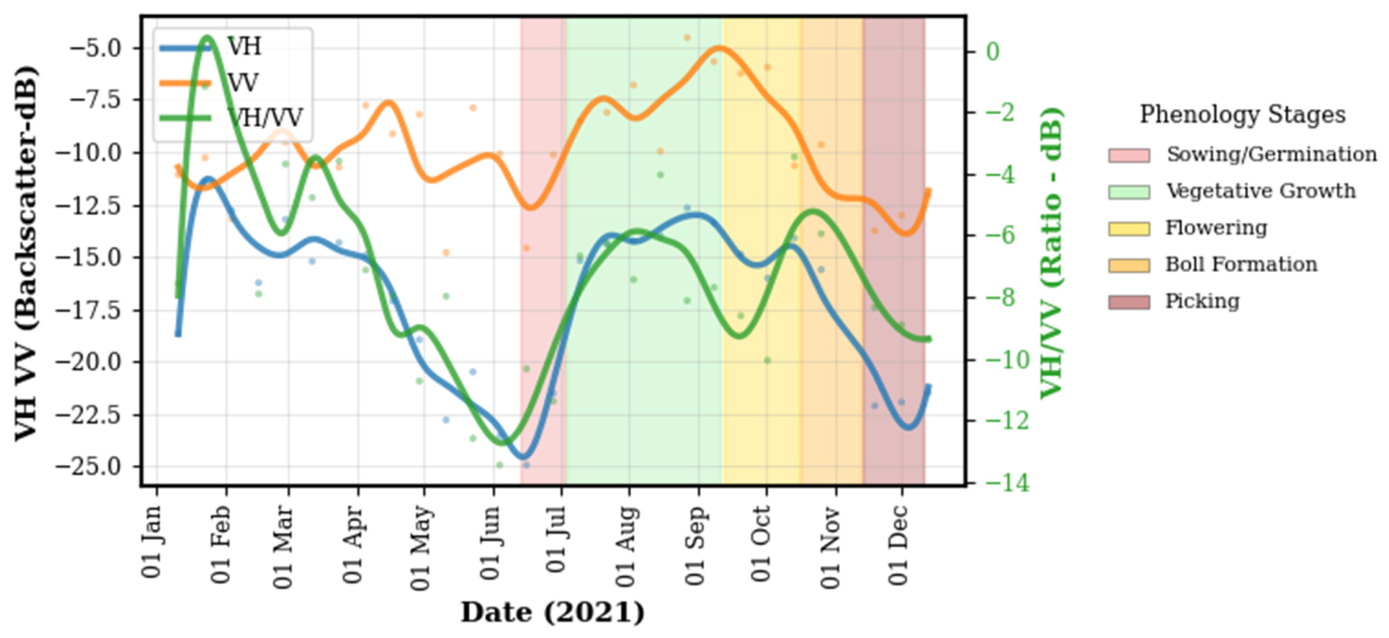
- Analyze SAR-derived temporal profiles (VV, VH, VH/VV) to understand crop-specific phenological behavior across agroclimatic zones.
- Extract and evaluate phenological metrics, including key thresholds, duration measures, phenological curve shapes, and peak signal values, to identify robust features for crop separation and phenological interpretation.
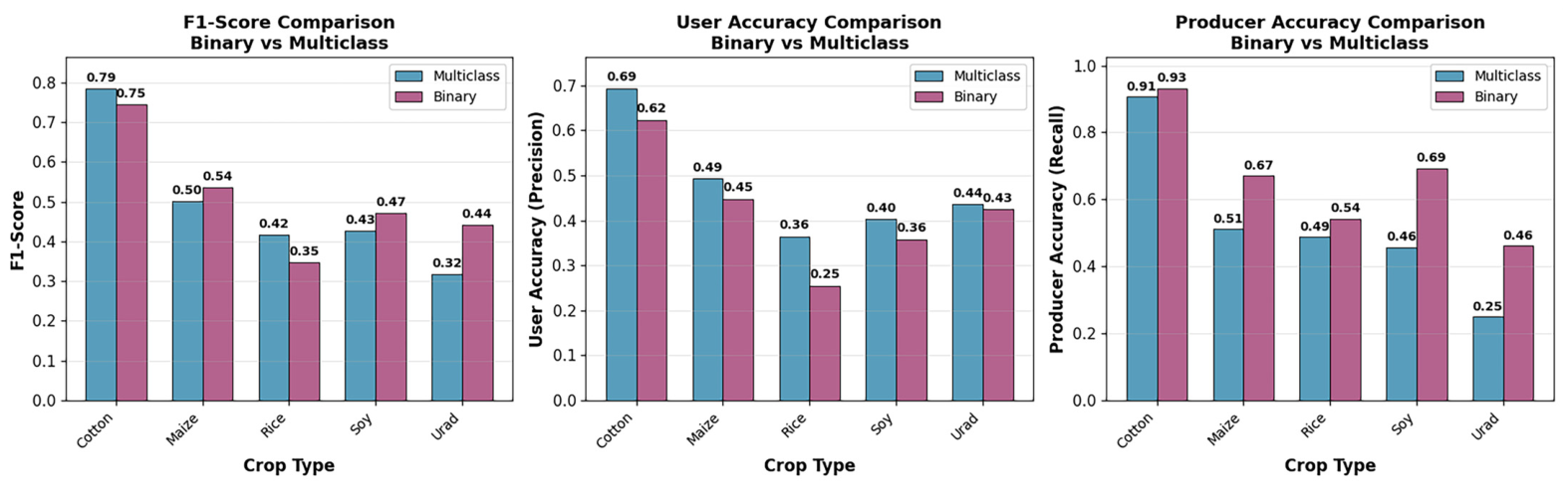
- Assess classification performance and cross-regional transferability of phenological metrics using Random Forest classifiers, highlighting both operational potential and limitations in smallholder systems.
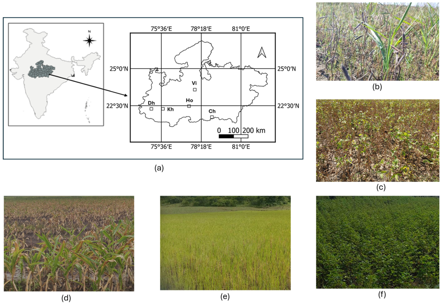
2. Study Area
3. Data and Methods
3.1. SAR Time Series Processing
3.2. SAR Phenological Metrics
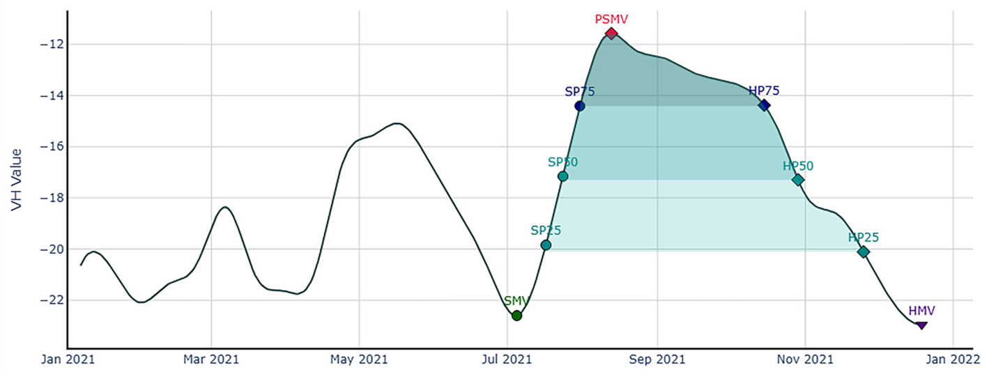
- Set A (Seasonal Extremes): Peak season maximum value (PSMV), sowing period minimum value (SMV), harvest period minimum value (HMV), and their corresponding dates (PSMD, SMD, HMD). Local minima and maxima were identified from the daily time series, with SMV and HMV selected as minima near the sowing and harvesting periods based on monsoon crop calendars, and PSMV as the maximum during peak vegetation growth.
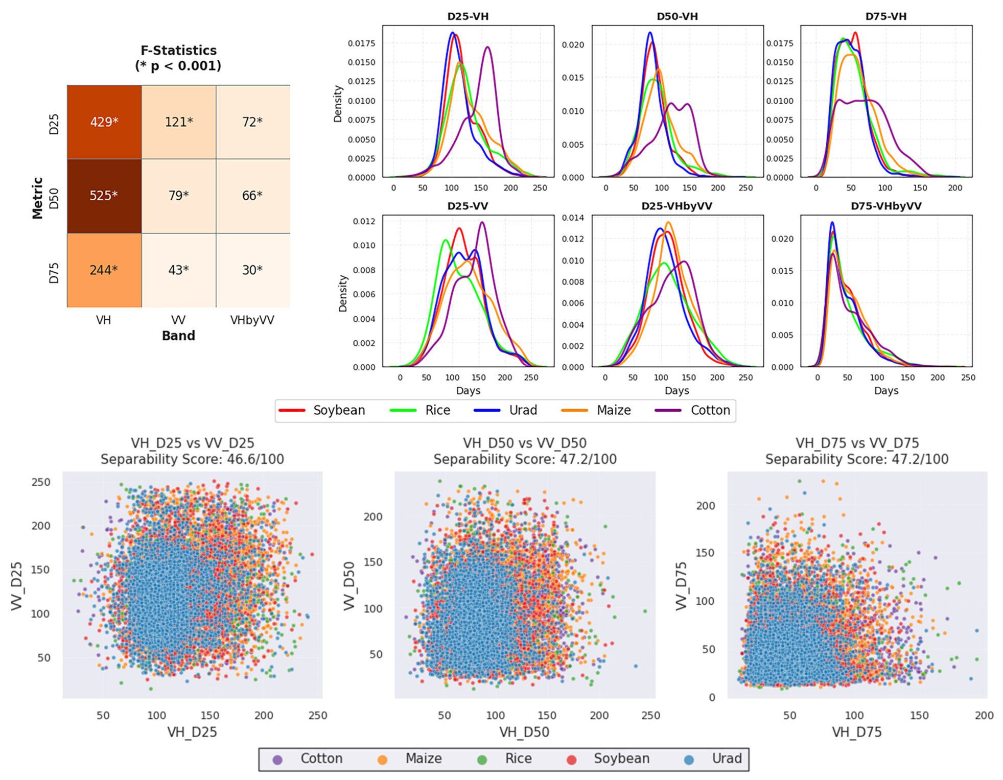
- Set B (Threshold Crossings): Dates and values when the signal crossed 25%, 50%, and 75% of peak amplitude during both rising (sowing phase, SP) and declining (harvest phase, HP) limbs. Threshold values were computed as:
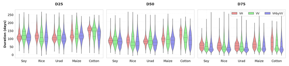
- Set C (Duration Metrics): Duration (days) between threshold crossings at 25%, 50%, and 75% levels:
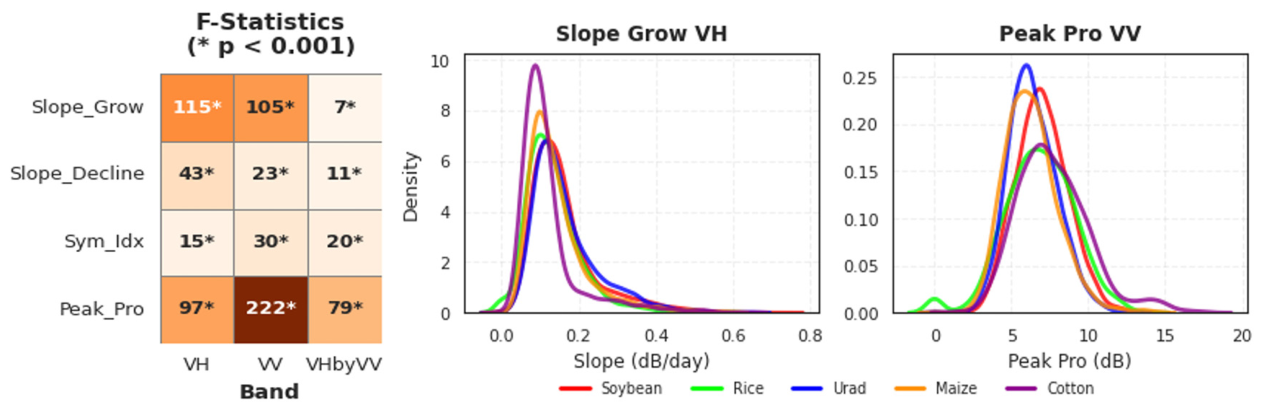
- Set D (Curve Shape Descriptors): Growth and decline slopes, symmetry index, and peak intensity:
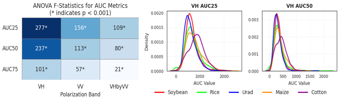
- Set E (Area Under the Curve): Integrated signal measures between matching threshold dates (AUC25, AUC50, AUC75), computed using trapezoidal integration on the baseline-adjusted signal within each interval. For example, AUC25 represents the area under the curve from SP25D to HP25D.
3.3. Statistical Analysis and Classification
4. Results
4.1. Crop-Specific Phenology Analysis
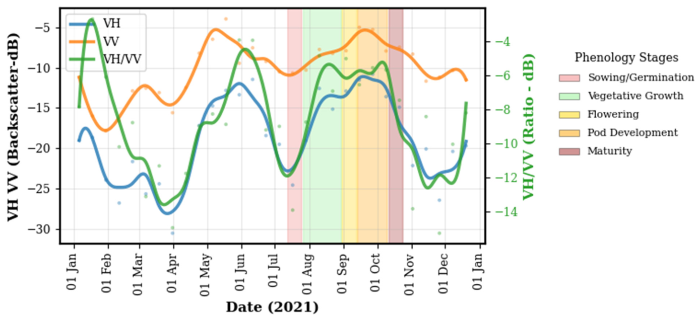
4.1.1. Soybean
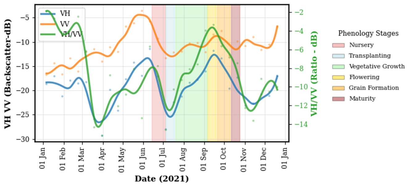
4.1.2. Rice
4.1.3. Urad (Black Gram)
4.1.4. Maize
4.1.5. Cotton
4.2. Inter-Crop Phenology Comparison
4.2.1. Variability of Local Extrema Values and Corresponding Dates
4.2.2. Threshold Crossing Metrics
4.2.3. Duration Metrics
4.2.4. Phenology Curve Shape Descriptors
4.2.5. Area Under the Curve
4.3. Crop Classification Using Phenological Metrics
4.4. Inter-District Generalization
5. Discussion
5.1. Phenological Signatures and Metric Performance
5.2. Classification Performance and Crop Separability
5.3. Cross-District Transferability
5.4. Limitations and Future Directions
6. Conclusions
Author Contributions
Funding
Data Availability Statement
Acknowledgments
Conflicts of Interest
References
- Dhillon, B.S.; Sohu, V.S. Climate Change Shocks and Crop Production: The Foodgrain Bowl of India as an Example. Indian J. Agron. 2024, 69, 1–10. [Google Scholar] [CrossRef] [Scilit]
- Rasid, N.; Prashnani, M.; Goswami, J.; Raju, P.L.N. Crop Damage Assessment in Flood Inundated Area of Morigaon District of Assam. Int. Arch. Photogramm. Remote Sens. Spat. Inf. Sci. 2019, XLII-3/W6, 489–491. [Google Scholar] [CrossRef] [Scilit]
- Singh, B.K.; Delgado-Baquerizo, M.; Egidi, E.; Guirado, E.; Leach, J.E.; Liu, H.; Trivedi, P. Climate Change Impacts on Plant Pathogens, Food Security and Paths Forward. Nat. Rev. Microbiol. 2023, 21, 640–656. [Google Scholar] [CrossRef] [Scilit] [PubMed]
- Ray, S.S.; Mamatha, S.; Gupta, S. Use of Remote Sensing in Crop Forecasting and Assessment of Impact of Natural Disasters: Operational Approaches in India. Crop Monit. Improv. Food Secur. 2014, 111–121. Available online: https://www.researchgate.net/publication/270023174_Use_of_Remote_Sensing_in_Crop_Forecasting_and_Assessment_of_Impact_of_Natural_Disasters_Operational_Approaches_in_India/citations (accessed on 5 April 2026).
- McNairn, H.; Shang, J. A Review of Multitemporal Synthetic Aperture Radar (SAR) for Crop Monitoring. In Multitemporal Remote Sensing: Methods and Applications; Ban, Y., Ed.; Springer International Publishing: Cham, Switzerland, 2016; pp. 317–340. [Google Scholar]
- Bisht, I.S.; Rana, J.C.; Pal Ahlawat, S. The Future of Smallholder Farming in India: Some Sustainability Considerations. Sustainability 2020, 12, 3751. [Google Scholar] [CrossRef] [Scilit]
- Khan, H.R.; Gillani, Z.; Jamal, M.H.; Athar, A.; Chaudhry, M.T.; Chao, H.; He, Y.; Chen, M. Early Identification of Crop Type for Smallholder Farming Systems Using Deep Learning on Time-Series Sentinel-2 Imagery. Sensors 2023, 23, 1779. [Google Scholar] [CrossRef] [Scilit]
- Uday, G.; Purse, B.V.; Kelley, D.I.; Vanak, A.; Samrat, A.; Chaudhary, A.; Rahman, M.; Gerard, F.F. Radar versus Optical: The Impact of Cloud Cover When Mapping Seasonal Surface Water for Health Applications in Monsoon-Affected India. PLoS ONE 2025, 20, e0314033. [Google Scholar] [CrossRef] [Scilit] [PubMed]
- Meroni, M.; d’Andrimont, R.; Vrieling, A.; Fasbender, D.; Lemoine, G.; Rembold, F.; Seguini, L.; Verhegghen, A. Comparing Land Surface Phenology of Major European Crops as Derived from SAR and Multispectral Data of Sentinel-1 and -2. Remote Sens. Environ. 2021, 253, 112232. [Google Scholar] [CrossRef] [Scilit]
- Veloso, A.; Mermoz, S.; Bouvet, A.; Le Toan, T.; Planells, M.; Dejoux, J.-F.; Ceschia, E. Understanding the Temporal Behavior of Crops Using Sentinel-1 and Sentinel-2-like Data for Agricultural Applications. Remote Sens. Environ. 2017, 199, 415–426. [Google Scholar] [CrossRef] [Scilit]
- Schlund, M.; Erasmi, S. Sentinel-1 Time Series Data for Monitoring the Phenology of Winter Wheat. Remote Sens. Environ. 2020, 246, 111814. [Google Scholar] [CrossRef] [Scilit]
- Wang, Y.; Fang, S.; Zhao, L.; Huang, X.; Jiang, X. Parcel-Based Summer Maize Mapping and Phenology Estimation Combined Using Sentinel-2 and Time Series Sentinel-1 Data. Int. J. Appl. Earth Obs. Geoinformation 2022, 108, 102720. [Google Scholar] [CrossRef] [Scilit]
- Ma, H.; Wang, L.; Sun, W.; Yang, S.; Gao, Y.; Fan, L.; Yang, G.; Wang, Y. A New Rice Identification Algorithm under Complex Terrain Combining Multi-Characteristic Parameters and Homogeneous Objects Based on Time Series Dual-Polarization Synthetic Aperture Radar. Front. Ecol. Evol. 2023, 11, 1093454. [Google Scholar] [CrossRef] [Scilit]
- Neetu; Prashnani, M.; Singh, D.K.; Joshi, R.; Ray, S.S. Understanding Crop Growing Pattern in Bardhaman District of West Bengal Using Multi-Date RISAT 1 MRS Data. Int. Arch. Photogramm. Remote Sens. Spat. Inf. Sci. 2014, XL-8, 861–864. [Google Scholar] [CrossRef] [Scilit]
- Singha, M.; Dong, J.; Zhang, G.; Xiao, X. High Resolution Paddy Rice Maps in Cloud-Prone Bangladesh and Northeast India Using Sentinel-1 Data. Sci. Data 2019, 6, 26. [Google Scholar] [CrossRef] [Scilit]
- Nasrallah, A.; Baghdadi, N.; El Hajj, M.; Darwish, T.; Belhouchette, H.; Faour, G.; Darwich, S.; Mhawej, M. Sentinel-1 Data for Winter Wheat Phenology Monitoring and Mapping. Remote Sens. 2019, 11, 2228. [Google Scholar] [CrossRef] [Scilit]
- Vreugdenhil, M.; Wagner, W.; Bauer-Marschallinger, B.; Pfeil, I.; Teubner, I.; Rüdiger, C.; Strauss, P. Sensitivity of Sentinel-1 Backscatter to Vegetation Dynamics: An Austrian Case Study. Remote Sens. 2018, 10, 1396. [Google Scholar] [CrossRef] [Scilit]
- Khabbazan, S.; Vermunt, P.; Steele-Dunne, S.; Arntz, L.R.; Marinetti, C.; van der Valk, D.; Iannini, L.; Molijn, R.; Westerdijk, K.; van der Sande, C. Crop Monitoring Using Sentinel-1 Data: A Case Study from The Netherlands. Remote Sens. 2019, 11, 1887. [Google Scholar] [CrossRef] [Scilit]
- Hong, Y.; Zhang, S.; Li, L. Research Progresses of Crop Growth Monitoring Based on Synthetic Aperture Radar Data. Smart Agric. 2024, 6, 46–62. [Google Scholar] [CrossRef]
- Wang, L.; Ma, H.; Gao, Y.; Chen, S.; Yang, S.; Lu, P.; Fan, L.; Wang, Y. Small- and Medium-Sized Rice Fields Identification in Hilly Areas Using All Available Sentinel-1/2 Images. Plant Methods 2024, 20, 25. [Google Scholar] [CrossRef] [Scilit] [PubMed]
- Kumari, M.; Murthy, C.S.; Pandey, V.; Bairagi, G.D. Soybean Cropland Mapping Using Multi-Temporal Sentinel-1 Data. Int. Arch. Photogramm. Remote Sens. Spat. Inf. Sci. 2019, XLII-3/W6, 109–114. [Google Scholar] [CrossRef] [Scilit]
- Shastri, B.; Haldar, D.; Mohan, S. Temporal Monitoring of SAR Polarimetric Parameters and Scattering Mechanism for Major Kharif Crops and Surrounding Land Use. Int. J. Sci. Eng. Technol. Res. 2015, 4, 416–424. [Google Scholar]
- Kothapalli Venkata, R.; Poloju, S.; Mullapudi Venkata Rama, S.S.; Gogineni, A.; Prabir Kumar, D.; Allakki Venkata, R.; Nagaraju, A.; Diwakar, P.G.; Dadhwal, V.K.; Singh, K.R.P. Multi-Incidence Angle RISAT-1 Hybrid Polarimetric SAR Data for Large Area Mapping of Maize Crop—A Case Study in Khagaria District, Bihar, India. Int. J. Remote Sens. 2017, 38, 5487–5501. [Google Scholar] [CrossRef] [Scilit]
- Kushwaha, A.; Dave, R.; Kumar, G.; Saha, K.; Khan, A. Assessment of Rice Crop Biophysical Parameters Using Sentinel-1 C-Band SAR Data. Adv. Space Res. 2022, 70, 3833–3844. [Google Scholar] [CrossRef] [Scilit]
- Ghosh, A.; Nanda, M.K.; Sarkar, D.; Sarkar, S.; Brahmachari, K.; Mainuddin, M. Kharif Rice Growth and Area Monitoring in Gosaba CD Block of Indian Sundarbans Region Using Multi-Temporal Dual-Pol SAR Data. Environ. Dev. Sustain. 2025, 27, 6331–6348. [Google Scholar] [CrossRef] [Scilit]
- Kumaraperumal, R.; Shama, M.; Kannan, B.; Ragunath, K.P.; Jagadeeswaran, R. Sentinel 1A SAR Backscattering Signature of Maize and Cotton Crops. Madras Agric. J. 2017, 104, 54–57. [Google Scholar] [CrossRef] [Scilit]
- Kumar, D.A.; Srikanth, P.; Neelima, T.L.; Devi, M.U.; Suresh, K.; Murthy, C.S. Monitoring of Spectral Signatures of Maize Crop Using Temporal SAR and Optical Remote Sensing Data. Int. J. Bio-Resour. Stress Manag. 2021, 12, 745–750. [Google Scholar] [CrossRef] [Scilit]
- Verma, A.; Kumar, A.; Lal, K. Kharif Crop Characterization Using Combination of SAR and MSI Optical Sentinel Satellite Datasets. J. Earth Syst. Sci. 2019, 128, 230. [Google Scholar] [CrossRef] [Scilit]
- Neetu; Meshram, P.; Ray, S.S. Field-Level Crop Classification Using an Optimal Dataset of Multi-Temporal Sentinel-1 and Polarimetric RADARSAT-2 SAR Data with Machine Learning Algorithms. J. Indian Soc. Remote Sens. 2021, 49, 2945–2958. [Google Scholar] [CrossRef] [Scilit]
- Kim, Y.; Jackson, T.; Bindlish, R.; Lee, H.; Hong, S. Radar Vegetation Index for Estimating the Vegetation Water Content of Rice and Soybean. IEEE Geosci. REMOTE Sens. Lett. 2012, 9, 564–568. [Google Scholar] [CrossRef] [Scilit]
- Nasirzadehdizaji, R.; Sanli, F.B.; Abdikan, S.; Cakir, Z.; Sekertekin, A.; Ustuner, M. Sensitivity Analysis of Multi-Temporal Sentinel-1 SAR Parameters to Crop Height and Canopy Coverage. Appl. Sci. 2019, 9, 655. [Google Scholar] [CrossRef] [Scilit]
- Rußwurm, M.; Körner, M. Temporal Vegetation Modelling Using Long Short-Term Memory Networks for Crop Identification from Medium-Resolution Multi-Spectral Satellite Images. In Proceedings of the 2017 IEEE Conference on Computer Vision and Pattern Recognition Workshops (CVPRW), Honolulu, HI, USA, 21–26 July 2017; pp. 1496–1504. [Google Scholar]
- Crisóstomo de Castro Filho, H.; Abílio de Carvalho Júnior, O.; Ferreira de Carvalho, O.L.; Pozzobon de Bem, P.; dos Santos de Moura, R.; Olino de Albuquerque, A.; Rosa Silva, C.; Guimarães Ferreira, P.H.; Fontes Guimarães, R.; Trancoso Gomes, R.A. Rice Crop Detection Using LSTM, Bi-LSTM, and Machine Learning Models from Sentinel-1 Time Series. Remote Sens. 2020, 12, 2655. [Google Scholar] [CrossRef] [Scilit]
- Ndikumana, E.; Ho Tong Minh, D.; Baghdadi, N.; Courault, D.; Hossard, L. Deep Recurrent Neural Network for Agricultural Classification Using Multitemporal SAR Sentinel-1 for Camargue, France. Remote Sens. 2018, 10, 1217. [Google Scholar] [CrossRef] [Scilit]
- Bhan, M.; Sahu, R.; Agrawal, K.K.; Dubey, A.; Tiwari, D.K.; Singh, P.P. Farmers Perception on Climate Change and Its Impact on Agriculture in East Central India; AICRPAM—NICRA Department of Physics & Agrometeorology: Hyderabad, India, 2014. [Google Scholar]
- Prashnani, M.; Dupare, B.; Vadrevu, K.P.; Justice, C. Towards Food Security: Exploring the Spatio-Temporal Dynamics of Soybean in India. PLoS ONE 2024, 19, e0292005. [Google Scholar] [CrossRef] [Scilit]
- Harfenmeister, K.; Spengler, D.; Weltzien, C. Analyzing Temporal and Spatial Characteristics of Crop Parameters Using Sentinel-1 Backscatter Data. Remote Sens. 2019, 11, 1569. [Google Scholar] [CrossRef] [Scilit]
- Najem, S.; Baghdadi, N.; Bazzi, H.; Zribi, M. Incidence Angle Normalization of C-Band Radar Backscattering Coefficient over Agricultural Surfaces Using Dynamic Cosine Method. Remote. Sens. 2024, 16, 3838. [Google Scholar] [CrossRef] [Scilit]
- Feng, Z.; Zheng, X.; Li, L.; Li, B.; Chen, S.; Guo, T.; Wang, X.; Jiang, T.; Li, X.; Li, X. Dynamic Cosine Method for Normalizing Incidence Angle Effect on C-Band Radar Backscattering Coefficient for Maize Canopies Based on NDVI. Remote Sens. 2021, 13, 2856. [Google Scholar] [CrossRef] [Scilit]
- Eisfelder, C.; Boemke, B.; Gessner, U.; Sogno, P.; Alemu, G.; Hailu, R.; Mesmer, C.; Huth, J. Cropland and Crop Type Classification with Sentinel-1 and Sentinel-2 Time Series Using Google Earth Engine for Agricultural Monitoring in Ethiopia. Remote Sens. 2024, 16, 866. [Google Scholar] [CrossRef] [Scilit]
- Luo, J.; Xie, M.; Wu, Q.; Luo, J.; Gao, Q.; Shao, X.; Zhang, Y. Early Crop Identification Study Based on Sentinel-1/2 Images with Feature Optimization Strategy. Agriculture 2024, 14, 990. [Google Scholar] [CrossRef] [Scilit]
- Franch, B.; Moletto-Lobos, I.; Tarín-Mestre, J.; Mascolo, L.; Vermote, E.; Kalecinski, N.; Becker-Reshef, I.; San-Bautista, A.; Rubio, C.; San Francisco, S.; et al. The Yield Strikes Back: Enhancing the Transferability of Field Scale Wheat and Barley Yield Models by Leveraging Sentinel-1/2. Int. J. Appl. Earth Obs. Geoinf. 2026, 146, 105140. [Google Scholar] [CrossRef] [Scilit]
- Flores, L.; Nendel, C.; Bookhagen, B.; Oviedo Reyes, J.A.; Smith, T.; Ghazaryan, G. The Potential of Sentinel-1 Time Series for Large-Scale Assessment of Maize and Wheat Phenology across Germany. GIScience Remote Sens. 2025, 62, 2531593. [Google Scholar] [CrossRef] [Scilit]
- Chen, J.; Jönsson, P.; Tamura, M.; Gu, Z.; Matsushita, B.; Eklundh, L. A Simple Method for Reconstructing a High-Quality NDVI Time-Series Data Set Based on the Savitzky–Golay Filter. Remote Sens. Environ. 2004, 91, 332–344. [Google Scholar] [CrossRef] [Scilit]
- Steinbach, S.; Hentschel, E.; Hentze, K.; Rienow, A.; Umulisa, V.; Zwart, S.J.; Nelson, A. Automatization and Evaluation of a Remote Sensing-Based Indicator for Wetland Health Assessment in East Africa on National and Local Scales. Ecol. Inform. 2023, 75, 102032. [Google Scholar] [CrossRef] [Scilit]
- Hao, P.; Tang, H.; Chen, Z.; Liu, Z. Early-Season Crop Mapping Using Improved Artificial Immune Network (IAIN) and Sentinel Data. PeerJ 2018, 6, e5431. [Google Scholar] [CrossRef] [Scilit]
- Ahmed, Z.; Nalley, L.; Brye, K.; Steven Green, V.; Popp, M.; Shew, A.M.; Connor, L. Winter-Time Cover Crop Identification: A Remote Sensing-Based Methodological Framework for New and Rapid Data Generation. Int. J. Appl. Earth Obs. Geoinf. 2023, 125, 103564. [Google Scholar] [CrossRef] [Scilit]
- Bao, X.; Zhang, R.; Lv, J.; Wu, R.; Zhang, H.; Chen, J.; Zhang, B.; Ouyang, X.; Liu, G. Vegetation Descriptors from Sentinel-1 SAR Data for Crop Growth Monitoring. ISPRS J. Photogramm. Remote Sens. 2023, 203, 86–114. [Google Scholar] [CrossRef] [Scilit]
- Yang, H.; Pan, B.; Li, N.; Wang, W.; Zhang, J.; Zhang, X. A Systematic Method for Spatio-Temporal Phenology Estimation of Paddy Rice Using Time Series Sentinel-1 Images. Remote Sens. Environ. 2021, 259, 112394. [Google Scholar] [CrossRef] [Scilit]
- Wang, M.; Wang, J.; Chen, L.; Du, Z. Mapping Paddy Rice and Rice Phenology with Sentinel-1 SAR Time Series Using a Unified Dynamic Programming Framework. Open Geosci. 2022, 14, 414–428. [Google Scholar] [CrossRef] [Scilit]
- Lasko, K.; Vadrevu, K.P.; Tran, V.T.; Justice, C. Mapping Double and Single Crop Paddy Rice with Sentinel-1A at Varying Spatial Scales and Polarizations in Hanoi, Vietnam. IEEE J. Sel. Top. Appl. Earth Obs. Remote Sens. 2018, 11, 498–512. [Google Scholar] [CrossRef] [Scilit]
- Xiao, W.; Xu, S.; He, T. Mapping Paddy Rice with Sentinel-1/2 and Phenology-, Object-Based Algorithm—A Implementation in Hangjiahu Plain in China Using GEE Platform. Remote Sens. 2021, 13, 990. [Google Scholar] [CrossRef] [Scilit]
- Ma, Y.; Jiang, G.; Huang, J.; Shen, Y.; Guan, H.; Dong, Y.; Li, J.; Hu, C. Evaluating the Ability of the Sentinel-1 Cross-Polarization Ratio to Detect Spring Maize Phenology Using Adaptive Dynamic Threshold. Remote Sens. 2024, 16, 826. [Google Scholar] [CrossRef] [Scilit]
- Villarroya-Carpio, A.; Lopez-Sanchez, J.M.; Engdahl, M.E. Sentinel-1 Interferometric Coherence as a Vegetation Index for Agriculture. Remote Sens. Environ. 2022, 280, 113208. [Google Scholar] [CrossRef] [Scilit]
- Tefera, A.T.; Banerjee, B.P.; Pandey, B.R.; James, L.; Puri, R.R.; Cooray, O.; Marsh, J.; Richards, M.; Kant, S.; Fitzgerald, G.J.; et al. Estimating Early Season Growth and Biomass of Field Pea for Selection of Divergent Ideotypes Using Proximal Sensing. Field Crops Res. 2022, 277, 108407. [Google Scholar] [CrossRef] [Scilit]
- Belgiu, M.; Bijker, W.; Csillik, O.; Stein, A. Phenology-Based Sample Generation for Supervised Crop Type Classification. Int. J. Appl. Earth Obs. Geoinf. 2021, 95, 102264. [Google Scholar] [CrossRef] [Scilit]
- Skakun, S.; Kussul, N.; Shelestov, A.Y.; Lavreniuk, M.; Kussul, O. Efficiency Assessment of Multitemporal C-Band Radarsat-2 Intensity and Landsat-8 Surface Reflectance Satellite Imagery for Crop Classification in Ukraine. IEEE J. Sel. Top. Appl. Earth Obs. Remote Sens. 2016, 9, 3712–3719. [Google Scholar] [CrossRef] [Scilit]
- Moumni, A.; Lahrouni, A. Machine Learning-Based Classification for Crop-Type Mapping Using the Fusion of High-Resolution Satellite Imagery in a Semiarid Area. Scientifica 2021, 2021, 8810279. [Google Scholar] [CrossRef] [Scilit] [PubMed]
- Ferrant, S.; Selles, A.; Le Page, M.; Herrault, P.-A.; Pelletier, C.; Al-Bitar, A.; Mermoz, S.; Gascoin, S.; Bouvet, A.; Saqalli, M.; et al. Detection of Irrigated Crops from Sentinel-1 and Sentinel-2 Data to Estimate Seasonal Groundwater Use in South India. Remote. Sens. 2017, 9, 1119. [Google Scholar] [CrossRef] [Scilit]
- Sellaperumal, P.; Kaliaperumal, R.; Dhanaraju, M.; Sudarmanian, N.S.; Shanmugapriya, P.; Satheesh, S.; Manikandan, S.; Tamil Mounika, R.; Sivamurugan, A.P.; Marimuthu, R.; et al. Time Series Analysis of Sentinel 1 A SAR Data to Retrieve Annual Rice Area Maps and Long-Term Dynamics of Start of Season. Sci. Rep. 2025, 15, 8202. [Google Scholar] [CrossRef] [Scilit]
- d’Andrimont, R.; Verhegghen, A.; Lemoine, G.; Kempeneers, P.; Meroni, M.; van der Velde, M. From Parcel to Continental Scale—A First European Crop Type Map Based on Sentinel-1 and LUCAS Copernicus in-Situ Observations. Remote Sens. Environ. 2021, 266, 112708. [Google Scholar] [CrossRef] [Scilit]
- Rao, P.; Zhou, W.; Bhattarai, N.; Srivastava, A.K.; Singh, B.; Poonia, S.; Lobell, D.B.; Jain, M. Using Sentinel-1, Sentinel-2, and Planet Imagery to Map Crop Type of Smallholder Farms. Remote Sens. 2021, 13, 1870. [Google Scholar] [CrossRef] [Scilit]
- Löw, F.; Duveiller, G. Defining the Spatial Resolution Requirements for Crop Identification Using Optical Remote Sensing. Remote Sens. 2014, 6, 9034–9063. [Google Scholar] [CrossRef] [Scilit]
- Inglada, J.; Arias, M.; Tardy, B.; Hagolle, O.; Valero, S.; Morin, D.; Dedieu, G.; Sepulcre, G.; Bontemps, S.; Defourny, P.; et al. Assessment of an Operational System for Crop Type Map Production Using High Temporal and Spatial Resolution Satellite Optical Imagery. Remote Sens. 2015, 7, 12356–12379. [Google Scholar] [CrossRef] [Scilit]
- Estes, L.D.; Ye, S.; Song, L.; Luo, B.; Eastman, J.R.; Meng, Z.; Zhang, Q.; McRitchie, D.; Debats, S.R.; Muhando, J.; et al. High Resolution, Annual Maps of Field Boundaries for Smallholder-Dominated Croplands at National Scales. Front. Artif. Intell. 2022, 4, 744863. [Google Scholar] [CrossRef] [Scilit]
- Zhao, J.; Zhong, Y.; Hu, X.; Wei, L.; Zhang, L. A Robust Spectral-Spatial Approach to Identifying Heterogeneous Crops Using Remote Sensing Imagery with High Spectral and Spatial Resolutions. Remote Sens. Environ. 2020, 239, 111605. [Google Scholar] [CrossRef] [Scilit]
- Khan, W.; Minallah, N.; Sher, M.; Khan, M.A.; Rehman, A.U.; Al-Ansari, T.; Bermak, A. Advancing Crop Classification in Smallholder Agriculture: A Multifaceted Approach Combining Frequency-Domain Image Co-Registration, Transformer-Based Parcel Segmentation, and Bi-LSTM for Crop Classification. PLoS ONE 2024, 19, e0299350. [Google Scholar] [CrossRef] [Scilit]
- Schlund, M. Potential of Sentinel-1 Time-Series Data for Monitoring the Phenology of European Temperate Forests. ISPRS J. Photogramm. Remote Sens. 2025, 223, 131–145. [Google Scholar] [CrossRef] [Scilit]
- Löw, J.; Conrad, C.; Hill, S.; Thiel, M.; Ullmann, T.; Otte, I. A Novel Approach to Assessing the Tracking Accuracy of Crop Phenology for Multi-Orbit and Multi-Feature Sentinel-1 Time Series. Sci. Remote Sens. 2026, 13, 100370. [Google Scholar] [CrossRef] [Scilit]
- Dronova, I.; Taddeo, S. Remote Sensing of Phenology: Towards the Comprehensive Indicators of Plant Community Dynamics from Species to Regional Scales. J. Ecol. 2022, 110, 1460–1487. [Google Scholar] [CrossRef] [Scilit]
- Liu, C.; Chen, Z.; Shao, Y.; Chen, J.; Hasi, T.; Pan, H. Research Advances of SAR Remote Sensing for Agriculture Applications: A Review. J. Integr. Agric. 2019, 18, 506–525. [Google Scholar] [CrossRef] [Scilit]
- Shang, J.; Liu, J.; Chen, Z.; McNairn, H.; Davidson, A. Recent Advancement of Synthetic Aperture Radar (SAR) Systems and Their Applications to Crop Growth Monitoring. In Recent Remote Sensing Sensor Applications—Satellites and Unmanned Aerial Vehicles (UAVs); IntechOpen: London, UK, 2022. [Google Scholar] [CrossRef] [Scilit]
- Paek, S.W.; Balasubramanian, S.; Kim, S.; Weck, O. de Small-Satellite Synthetic Aperture Radar for Continuous Global Biospheric Monitoring: A Review. Remote Sens. 2020, 12, 2546. [Google Scholar] [CrossRef] [Scilit]
- Ignatenko, V.; Laurila, P.; Radius, A.; Lamentowski, L.; Antropov, O.; Muff, D. ICEYE Microsatellite SAR Constellation Status Update: Evaluation of First Commercial Imaging Modes; IEEE: New York, NY, USA, 2021. [Google Scholar]
- Kraatz, S.; Torbick, N.; Jiao, X.; Huang, X.; Robertson, L.D.; Davidson, A.; McNairn, H.; Cosh, M.H.; Siqueira, P. Comparison between Dense L-Band and C-Band Synthetic Aperture Radar (SAR) Time Series for Crop Area Mapping over a NISAR Calibration-Validation Site. Agronomy 2021, 11, 273. [Google Scholar] [CrossRef] [Scilit]
- Blickensdörfer, L.; Schwieder, M.; Pflugmacher, D.; Nendel, C.; Erasmi, S.; Hostert, P. Mapping of Crop Types and Crop Sequences with Combined Time Series of Sentinel-1, Sentinel-2 and Landsat 8 Data for Germany. Remote Sens. Environ. 2022, 269, 112831. [Google Scholar] [CrossRef] [Scilit]
- Orynbaikyzy, A.; Gessner, U.; Mack, B.; Conrad, C. Crop Type Classification Using Fusion of Sentinel-1 and Sentinel-2 Data: Assessing the Impact of Feature Selection, Optical Data Availability, and Parcel Sizes on the Accuracies. Remote Sens. 2020, 12, 2779. [Google Scholar] [CrossRef] [Scilit]
- El Imanni, H.S.; El Harti, A.; Hssaisoune, M.; Velastegui-Montoya, A.; Elbouzidi, A.; Addi, M.; El Iysaouy, L.; El Hachimi, J. Rapid and Automated Approach for Early Crop Mapping Using Sentinel-1 and Sentinel-2 on Google Earth Engine; A Case of a Highly Heterogeneous and Fragmented Agricultural Region. J. Imaging 2022, 8, 316. [Google Scholar] [CrossRef] [Scilit] [PubMed]








Disclaimer/Publisher’s Note: The statements, opinions and data contained in all publications are solely those of the individual author(s) and contributor(s) and not of MDPI and/or the editor(s). MDPI and/or the editor(s) disclaim responsibility for any injury to people or property resulting from any ideas, methods, instructions or products referred to in the content. |
© 2026 by the authors. Licensee MDPI, Basel, Switzerland. This article is an open access article distributed under the terms and conditions of the Creative Commons Attribution (CC BY) license.
Share and Cite
Prashnani, M.; Justice, C. Evaluating SAR-Derived Phenological Metrics for Monsoon (Kharif) Crop Monitoring in Diversified Agricultural Systems: Insights from Central India. Remote Sens. 2026, 18, 1238. https://doi.org/10.3390/rs18081238
Prashnani M, Justice C. Evaluating SAR-Derived Phenological Metrics for Monsoon (Kharif) Crop Monitoring in Diversified Agricultural Systems: Insights from Central India. Remote Sensing. 2026; 18(8):1238. https://doi.org/10.3390/rs18081238
Chicago/Turabian StylePrashnani, Meghavi, and Chris Justice. 2026. "Evaluating SAR-Derived Phenological Metrics for Monsoon (Kharif) Crop Monitoring in Diversified Agricultural Systems: Insights from Central India" Remote Sensing 18, no. 8: 1238. https://doi.org/10.3390/rs18081238
APA StylePrashnani, M., & Justice, C. (2026). Evaluating SAR-Derived Phenological Metrics for Monsoon (Kharif) Crop Monitoring in Diversified Agricultural Systems: Insights from Central India. Remote Sensing, 18(8), 1238. https://doi.org/10.3390/rs18081238