Review of Snow Identification Algorithms: From Traditional Machine Learning to Semantic Methods


Highlights
- This paper systematically reviews machine learning algorithms for snow cover recognition, detailing the process of extracting semantic features and marking the first comprehensive survey from a machine learning perspective.
- It categorizes algorithms based on task objectives, comparing their strengths and weaknesses across optical remote sensing, SAR, passive microwave, and multi-source data fusion tasks, while also providing an in-depth analysis of attention mechanisms and transformer architectures for future advancements.
- As a review from a machine learning standpoint, it establishes a foundational framework for researchers, consolidating current methodologies and highlighting key techniques for snow cover analysis.
- By offering a task-oriented comparison and emphasizing emerging architectures like transformers, it guides the optimization of multi-source data fusion and points toward innovative directions for leveraging deep learning in snow monitoring applications.
Abstract
1. Introduction
2. Related Work
2.1. Four Tasks in Snow Recognition
2.1.1. Optical Tasks
2.1.2. SAR Tasks
2.1.3. Passive Microwave Tasks
2.1.4. Multi-Source Tasks
2.2. Datasets
2.2.1. Optical Datasets
2.2.2. SAR Datasets
2.2.3. Passive Microwave Datasets
2.3. Machine Learning
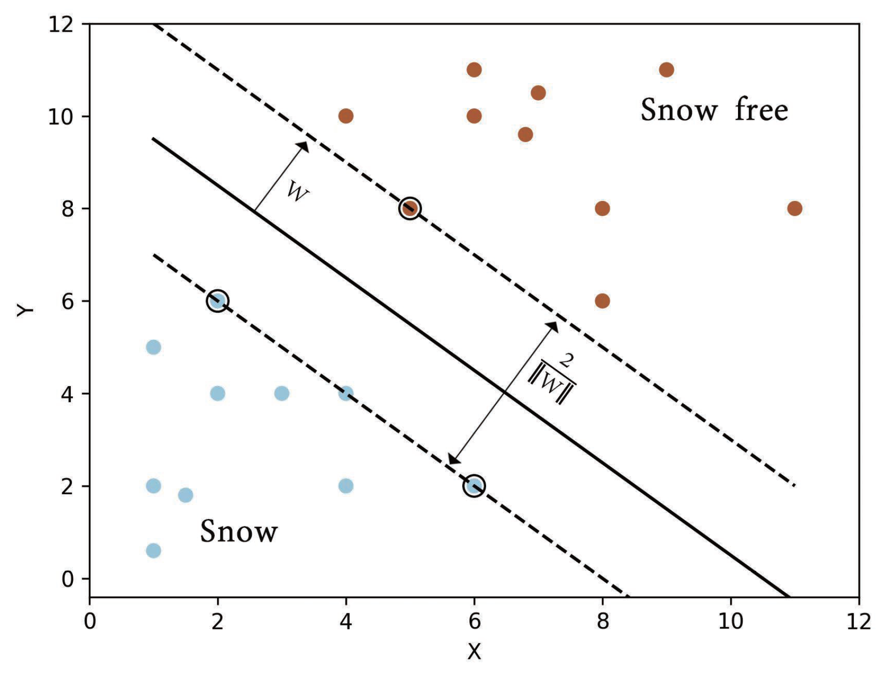
2.3.1. Support Vector Machine
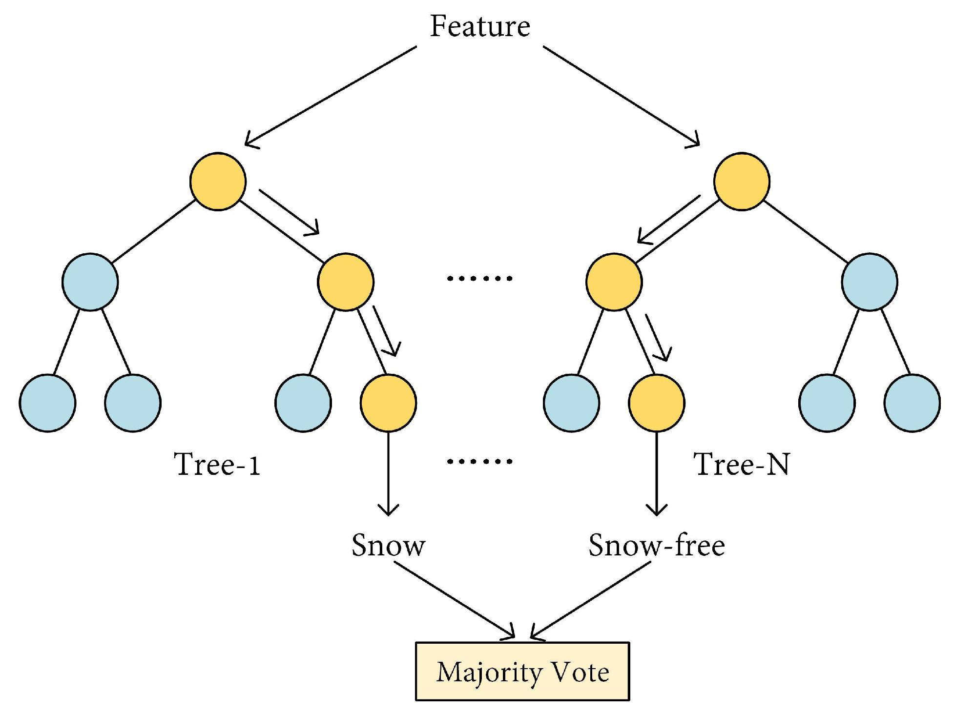
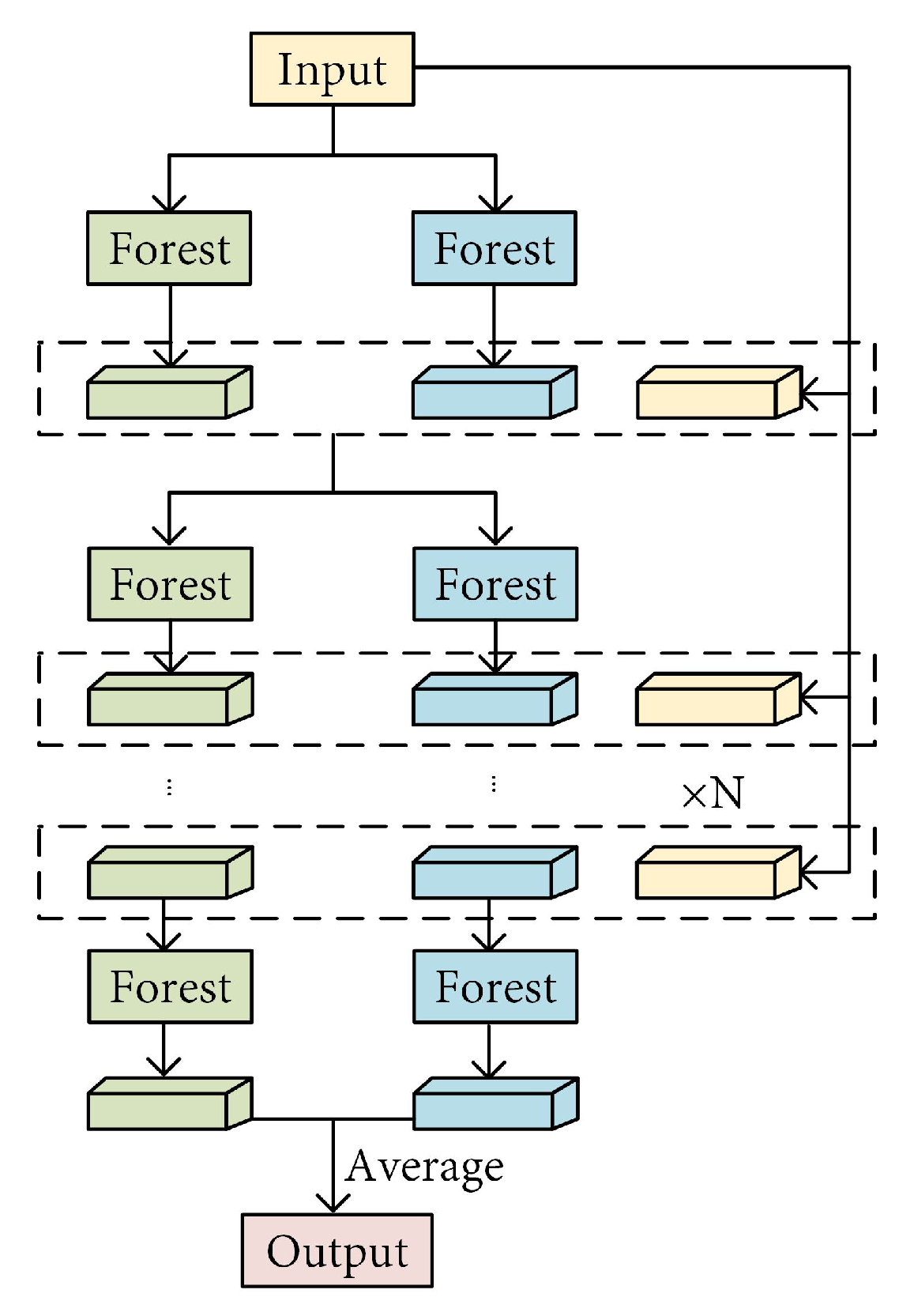
2.3.2. Random Forest
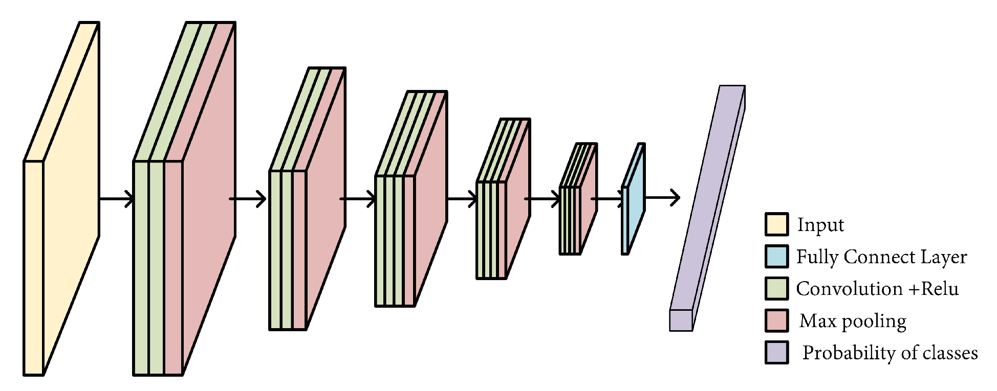
2.3.3. Convolutional Neural Network
2.4. Evaluation Metrics
3. Traditional Machine Learning-Based Methods
3.1. Optical Task
3.1.1. Feature Extraction Methods for Optical Tasks
3.1.2. Application and Optimization in Optical Scenes
3.2. SAR Tasks
3.3. Passive Microwave Tasks
3.4. Multi-Source Tasks
4. Deep-Learning-Based Methods
4.1. Optical Tasks
4.2. SAR Tasks
4.3. Passive Microwave Tasks
4.4. Multi-Source Tasks
5. Summary and Outlook
Author Contributions
Funding
Data Availability Statement
Acknowledgments
Conflicts of Interest
References
- You, Q.; Wu, T.; Shen, L.; Pepin, N.; Zhang, L.; Jiang, Z.; Wu, Z.; Kang, S.; AghaKouchak, A. Review of snow cover variation over the Tibetan Plateau and its influence on the broad climate system. Earth-Sci. Rev. 2020, 201, 103043. [Google Scholar] [CrossRef] [Scilit]
- Dumont, M.; Gascoin, S. Optical Remote Sensing of Snow Cover. In Land Surface Remote Sensing in Continental Hydrology; Elsevier: Amsterdam, The Netherlands, 2016; pp. 115–137. [Google Scholar] [CrossRef] [Scilit]
- Bokhorst, S.; Pedersen, S.H.; Brucker, L.; Anisimov, O.; Bjerke, J.W.; Brown, R.D.; Ehrich, D.; Essery, R.L.; Heilig, A.; Ingvander, S.; et al. Changing Arctic snow cover: A review of recent developments and assessment of future needs for observations, modelling, and impacts. Ambio 2016, 45, 516–537. [Google Scholar] [CrossRef] [Scilit] [PubMed]
- Thackeray, C.W.; Derksen, C.; Fletcher, C.G.; Hall, A. Snow and climate: Feedbacks, drivers, and indices of change. Curr. Clim. Chang. Rep. 2019, 5, 322–333. [Google Scholar] [CrossRef] [Scilit]
- Edwards, A.C.; Scalenghe, R.; Freppaz, M. Changes in the seasonal snow cover of alpine regions and its effect on soil processes: A review. Quat. Int. 2007, 162, 172–181. [Google Scholar] [CrossRef] [Scilit]
- Chen, B.; Xia, M.; Qian, M.; Huang, J. MANet: A multi-level aggregation network for semantic segmentation of high-resolution remote sensing images. Int. J. Remote Sens. 2022, 43, 5874–5894. [Google Scholar] [CrossRef] [Scilit]
- Hall, D.K.; Riggs, G.A.; Salomonson, V.V. Development of methods for mapping global snow cover using moderate resolution imaging spectroradiometer data. Remote Sens. Environ. 1995, 54, 127–140. [Google Scholar] [CrossRef] [Scilit]
- Hall, D.K.; Riggs, G.A.; Salomonson, V.V.; DiGirolamo, N.E.; Bayr, K.J. MODIS snow-cover products. Remote Sens. Environ. 2002, 83, 181–194. [Google Scholar] [CrossRef] [Scilit]
- Hall, D.K.; Riggs, G.A. Accuracy assessment of the MODIS snow products. Hydrol. Processes 2007, 21, 1534–1547. [Google Scholar] [CrossRef] [Scilit]
- Klein, A.G.; Barnett, A. Validation of daily MODIS snow cover maps of the Upper Rio Grande River Basin for the 2000–2001 snow year. Remote Sens. Environ. 2003, 86, 162–176. [Google Scholar] [CrossRef] [Scilit]
- Klein, A.G.; Hall, D.K.; Riggs, G.A. Improving snow cover mapping in forests through the use of a canopy reflectance model. Hydrol. Processes 1998, 12, 1723–1744. [Google Scholar] [CrossRef]
- Boukabara, S.A.; Weng, F.; Liu, Q. Passive microwave remote sensing of extreme weather events using NOAA-18 AMSUA and MHS. IEEE Trans. Geosci. Remote Sens. 2007, 45, 2228–2246. [Google Scholar] [CrossRef]
- Chang, T.; Gloersen, P.; Schmugge, T.; Wilheit, T.; Zwally, H. Microwave emission from snow and glacier ice. J. Glaciol. 1976, 16, 23–39. [Google Scholar] [CrossRef] [Scilit]
- Mätzler, C.; Wiesmann, A. Extension of the microwave emission model of layered snowpacks to coarse-grained snow. Remote Sens. Environ. 1999, 70, 317–325. [Google Scholar] [CrossRef] [Scilit]
- Pulliainen, J.T.; Grandell, J.; Hallikainen, M.T. HUT snow emission model and its applicability to snow water equivalent retrieval. IEEE Trans. Geosci. Remote Sens. 1999, 37, 1378–1390. [Google Scholar] [CrossRef] [Scilit]
- Snehmani; Singh, M.K.; Gupta, R.; Bhardwaj, A.; Joshi, P.K. Remote sensing of mountain snow using active microwave sensors: A review. Geocarto Int. 2015, 30, 1–27. [Google Scholar] [CrossRef] [Scilit]
- Guangjun, H.; Pengfeng, X.; Xuezhi, F.; Xueliang, Z.; Zuo, W.; Ni, C. Extracting Snow Cover in Mountain Areas Based on SAR and Optical Data. IEEE Geosci. Remote Sens. Lett. 2015, 12, 1136–1140. [Google Scholar] [CrossRef] [Scilit]
- Zhu, L.; Zhang, Y.; Wang, J.; Tian, W.; Liu, Q.; Ma, G.; Kan, X.; Chu, Y. Downscaling snow depth mapping by fusion of microwave and optical remote-sensing data based on deep learning. Remote Sens. 2021, 13, 584. [Google Scholar] [CrossRef] [Scilit]
- Xiao, X.; Zhang, T.; Zhong, X.; Shao, W.; Li, X. Support vector regression snow-depth retrieval algorithm using passive microwave remote sensing data. Remote Sens. Environ. 2018, 210, 48–64. [Google Scholar] [CrossRef] [Scilit]
- Largeron, C.; Dumont, M.; Morin, S.; Boone, A.; Lafaysse, M.; Metref, S.; Cosme, E.; Jonas, T.; Winstral, A.; Margulis, S.A. Toward Snow Cover Estimation in Mountainous Areas Using Modern Data Assimilation Methods: A Review. Front. Earth Sci. 2020, 8, 325. [Google Scholar] [CrossRef] [Scilit]
- Chen, J.; Xia, M.; Wang, D.; Lin, H. Double Branch Parallel Network for Segmentation of Buildings and Waters in Remote Sensing Images. Remote Sens. 2023, 15, 1536. [Google Scholar] [CrossRef] [Scilit]
- Chen, K.; Xia, M.; Lin, H.; Qian, M. Multi-scale Attention Feature Aggregation Network for Cloud and Cloud Shadow Segmentation. IEEE Trans. Geosci. Remote Sens. 2023, 61, 5612216. [Google Scholar]
- Zhu, X.X.; Tuia, D.; Mou, L.; Xia, G.S.; Zhang, L.; Xu, F.; Fraundorfer, F. Deep learning in remote sensing: A comprehensive review and list of resources. IEEE Geosci. Remote Sens. Mag. 2017, 5, 8–36. [Google Scholar] [CrossRef] [Scilit]
- Wieland, M.; Li, Y.; Martinis, S. Multi-sensor cloud and cloud shadow segmentation with a convolutional neural network. Remote Sens. Environ. 2019, 230, 111203. [Google Scholar] [CrossRef] [Scilit]
- Zheng, K.; Li, J.; Ding, L.; Yang, J.; Zhang, X.; Zhang, X. Cloud and Snow Segmentation in Satellite Images Using an Encoder–Decoder Deep Convolutional Neural Networks. ISPRS Int. J. Geo-Inf. 2021, 10, 462. [Google Scholar] [CrossRef] [Scilit]
- He, K.; Zhang, X.; Ren, S.; Sun, J. Spatial Pyramid Pooling in Deep Convolutional Networks for Visual Recognition. IEEE Trans. Pattern Anal. Mach. Intell. 2015, 37, 1904–1916. [Google Scholar] [CrossRef] [Scilit]
- Wang, Z.; Fan, B.; Tu, Z.; Li, H.; Chen, D. Cloud and Snow Identification Based on DeepLab V3+ and CRF Combined Model for GF-1 WFV Images. Remote Sens. 2022, 14, 4880. [Google Scholar] [CrossRef] [Scilit]
- Dietz, A.J.; Kuenzer, C.; Gessner, U.; Dech, S. Remote sensing of snow—A review of available methods. Int. J. Remote Sens. 2011, 33, 4094–4134. [Google Scholar] [CrossRef] [Scilit]
- Tsai, Y.L.S.; Dietz, A.; Oppelt, N.; Kuenzer, C. Remote Sensing of Snow Cover Using Spaceborne SAR: A Review. Remote Sens. 2019, 11, 1456. [Google Scholar] [CrossRef] [Scilit]
- Liu, P.; Choo, K.K.R.; Wang, L.; Huang, F. SVM or deep learning? A comparative study on remote sensing image classification. Soft Comput. 2016, 21, 7053–7065. [Google Scholar] [CrossRef] [Scilit]
- Brenning, A. Transforming feature space to interpret machine learning models. arXiv 2021, arXiv:2104.04295. [Google Scholar] [CrossRef] [Scilit]
- Dai, X.; Xia, M.; Weng, L.; Hu, K.; Lin, H.; Qian, M. Multi-Scale Location Attention Network for Building and Water Segmentation of Remote Sensing Image. IEEE Trans. Geosci. Remote Sens. 2023, 61, 5609519. [Google Scholar] [CrossRef] [Scilit]
- Hu, K.; Wang, T.; Shen, C.; Weng, C.; Zhou, F.; Xia, M.; Weng, L. Overview of Underwater 3D Reconstruction Technology Based on Optical Images. J. Mar. Sci. Eng. 2023, 11, 949. [Google Scholar] [CrossRef] [Scilit]
- Yue, J.; Fang, L.; Ghamisi, P.; Xie, W.; Li, J.; Chanussot, J.; Plaza, A. Optical Remote Sensing Image Understanding with Weak Supervision: Concepts, methods, and perspectives. IEEE Geosci. Remote Sens. Mag. 2022, 10, 250–269. [Google Scholar] [CrossRef] [Scilit]
- Xiao-Guang, Z.; Gang-Yao, K.; Jian-Wei, W. A Review of Polarimetric SAR Speckle Reduction. J. Image Graph. 2008, 13, 377–385. [Google Scholar]
- Joshi, N.; Baumann, M.; Ehammer, A.; Fensholt, R.; Grogan, K.; Hostert, P.; Jepsen, M.R.; Kuemmerle, T.; Meyfroidt, P.; Mitchard, E.T.; et al. A review of the application of optical and radar remote sensing data fusion to land use mapping and monitoring. Remote Sens. 2016, 8, 70. [Google Scholar] [CrossRef] [Scilit]
- Lusch, D.P. Introduction to Microwave Remote Sensing; Center for Remote Sensing and Geographic Information Science, Michigan State University: East Lansing, MI, USA, 1999. [Google Scholar]
- Ye, Y. Fast and robust registration of multimodal remote sensing images via dense orientated gradient feature. Int. Arch. Photogramm. Remote Sens. Spat. Inf. Sci. 2017, 42, 1009–1015. [Google Scholar] [CrossRef] [Scilit]
- Zhang, J. Multi-source remote sensing data fusion: Status and trends. Int. J. Image Data Fusion 2010, 1, 5–24. [Google Scholar] [CrossRef] [Scilit]
- Reiche, J.; Verbesselt, J.; Hoekman, D.; Herold, M. Fusing Landsat and SAR time series to detect deforestation in the tropics. Remote Sens. Environ. 2015, 156, 276–293. [Google Scholar] [CrossRef] [Scilit]
- Agrawal, S.; Khairnar, G. A comparative assessment of remote sensing imaging techniques: Optical, sar and lidar. Int. Arch. Photogramm. Remote Sens. Spat. Inf. Sci. 2019, 42, 1–6. [Google Scholar] [CrossRef] [Scilit]
- Liang, T.G.; Huang, X.D.; Wu, C.X.; Liu, X.Y.; Li, W.L.; Guo, Z.G.; Ren, J.Z. An application of MODIS data to snow cover monitoring in a pastoral area: A case study in Northern Xinjiang, China. Remote Sens. Environ. 2008, 112, 1514–1526. [Google Scholar] [CrossRef] [Scilit]
- Hall, D.K.; Riggs, G.A. MODIS/Terra Snow Cover Daily L3 Global 500 m SIN Grid, Version 6, 2016. Available online: https://nsidc.org/data/mod10a1/versions/6 (accessed on 30 March 2026).
- Zhang, G.; Gao, X.; Yang, Y.; Wang, M.; Ran, S. Controllably deep supervision and multi-scale feature fusion network for cloud and snow detection based on medium-and high-resolution imagery dataset. Remote Sens. 2021, 13, 4805. [Google Scholar] [CrossRef] [Scilit]
- Hughes, M.J.; Hayes, D.J. Automated detection of cloud and cloud shadow in single-date Landsat imagery using neural networks and spatial post-processing. Remote Sens. 2014, 6, 4907–4926. [Google Scholar] [CrossRef] [Scilit]
- Tran, H.; Nguyen, P.; Ombadi, M.; Hsu, K.l.; Sorooshian, S.; Qing, X. A cloud-free MODIS snow cover dataset for the contiguous United States from 2000 to 2017. Sci. Data 2019, 6, 180300. [Google Scholar] [CrossRef] [Scilit] [PubMed]
- Li, Z.; Shen, H.; Cheng, Q.; Liu, Y.; You, S.; He, Z. Deep learning based cloud detection for remote sensing images by the fusion of multi-scale convolutional features. arXiv 2018, arXiv:1810.05801. [Google Scholar]
- Hao, X.; Luo, S.; Che, T.; Wang, J.; Li, H.; Dai, L.; Huang, X.; Feng, Q. Accuracy assessment of four cloud-free snow cover products over the Qinghai-Tibetan Plateau. Int. J. Digit. Earth 2018, 12, 375–393. [Google Scholar] [CrossRef] [Scilit]
- Cortes, C.; Vapnik, V. Support-Vector Networks. Mach. Learn. 1995, 20, 273–297. [Google Scholar] [CrossRef] [Scilit]
- Gao, J.; Xu, L.; Huang, F. A spectral–textural kernel-based classification method of remotely sensed images. Neural Comput. Appl. 2015, 27, 431–446. [Google Scholar] [CrossRef] [Scilit]
- Breiman, L. Random forests. Mach. Learn. 2001, 45, 5–32. [Google Scholar] [CrossRef] [Scilit]
- Colditz, R.R. An Evaluation of Different Training Sample Allocation Schemes for Discrete and Continuous Land Cover Classification Using Decision Tree-Based Algorithms. Remote Sens. 2015, 7, 9655–9681. [Google Scholar] [CrossRef] [Scilit]
- Belgiu, M.; Drăguţ, L. Random forest in remote sensing: A review of applications and future directions. ISPRS J. Photogramm. Remote Sens. 2016, 114, 24–31. [Google Scholar] [CrossRef] [Scilit]
- Trimble. eCognition Developer 8.7.2. Reference Book, München; Trimble: Westminster, CO, USA, 2013. [Google Scholar]
- Trimble. Ecognition-Random Forest. 2013. Available online: https://www.sysdecoitalia.com/wp-content/uploads/2015/04/eCognition9.0.2_ReleaseNotes.pdf (accessed on 25 August 2025).
- R Development Core Team. R: A Language and Environment for Statistical Computing; R Foundation for Statistical Computing: Vienna, Austria, 2005; ISBN 3-900051-07-0. [Google Scholar]
- R-Development-Core-Team. R-Project Random Forest. 2005. Available online: http://www.r-project.org/ (accessed on 25 August 2025).
- Holmes, G.; Donkin, A.; Witten, I.H. Weka: A Machine Learning Workbench. In Proceedings of the Second Australian and New Zealand Conference on Intelligent Information Systems, Brisbane, Australia, 29 November–2 December 1994; pp. 357–361. [Google Scholar]
- Weka. 1994. Available online: https://weka.sourceforge.io/doc.dev/weka/classifiers/trees/RandomForest.html (accessed on 25 August 2025).
- Pedregosa, F.; Varoquaux, G.; Gramfort, A.; Michel, V.; Thirion, B.; Grisel, O.; Blondel, M.; Prettenhofer, P.; Weiss, R.; Dubourg, V. Scikit-Learn: Machine Learning in Python. J. Mach. Learn. Res. 2011, 12, 2825–2830. [Google Scholar]
- Scikit-Learn Random Forest. 2011. Available online: https://scikit-learn.org/stable/modules/generated/sklearn.ensemble.RandomForestClassifier.html (accessed on 25 August 2025).
- Waske, B.; van der Linden, S.; Oldenburg, C.; Jakimow, B.; Rabe, A.; Hostert, P. ImageRF–A User-Oriented Implementation for Remote Sensing Image Analysis with Random Forests. Environ. Model. Softw. 2012, 35, 192–193. [Google Scholar] [CrossRef] [Scilit]
- Schwarz, D.F.; König, I.R.; Ziegler, A. On Safari to Random Jungle: A Fast Implementation of Random Forests for High-Dimensional Data. Bioinformatics 2010, 26, 1752–1758. [Google Scholar] [CrossRef] [Scilit] [PubMed]
- Ranger Random Forest. 2010. Available online: https://cran.r-project.org/web/packages/tidypredict/vignettes/ranger.html (accessed on 25 August 2025).
- STATISTICA Randomforest. Available online: http://www.statsoft.com (accessed on 25 August 2025).
- Zhang, H.; Wang, M.; Chen, X. Willows: A Memory Efficient Tree and Forest Construction Package. BMC Bioinform. 2009, 10, 130. [Google Scholar] [CrossRef] [Scilit]
- Willows. 2009. Available online: https://ysph.yale.edu/c2s2/software/willows/ (accessed on 25 August 2025).
- andrej.karpathy. Matlab Random Forest. Available online: https://github.com/karpathy/Random-Forest-Matlab (accessed on 25 August 2025).
- Zhou, Z.H.; Feng, J. Deep forest. Natl. Sci. Rev. 2019, 6, 74–86. [Google Scholar] [CrossRef] [Scilit]
- Gcforest. 2017. Available online: https://github.com/LAMDA-NJU/Deep-Forest (accessed on 25 August 2025).
- Long, J.; Shelhamer, E.; Darrell, T. Fully Convolutional Networks for Semantic Segmentation. IEEE Trans. Pattern Anal. Mach. Intell. 2015, 39, 640–651. [Google Scholar]
- Hu, K.; Ding, Y.; Jin, J.; Weng, L.; Xia, M. Skeleton motion recognition based on multi-scale deep spatio-temporal features. Appl. Sci. 2022, 12, 1028. [Google Scholar] [CrossRef] [Scilit]
- Lecun, Y.; Bottou, L. Gradient-based learning applied to document recognition. Proc. IEEE 1998, 86, 2278–2324. [Google Scholar] [CrossRef] [Scilit]
- Krizhevsky, A.; Sutskever, I.; Hinton, G. ImageNet Classification with Deep Convolutional Neural Networks. In Proceedings of the Advances in Neural Information Processing Systems 25, Lake Tahoe, NV, USA, 3–6 December 2012. [Google Scholar]
- Simonyan, K.; Zisserman, A. Very Deep Convolutional Networks for Large-Scale Image Recognition. arXiv 2014, arXiv:1409.1556. [Google Scholar]
- He, K.; Zhang, X.; Ren, S.; Sun, J. Deep Residual Learning for Image Recognition. In Proceedings of the IEEE Conference on Computer Vision and Pattern Recognition, Las Vegas, NV, USA, 27–30 June 2016. [Google Scholar]
- Szegedy, C.; Vanhoucke, V.; Ioffe, S.; Shlens, J.; Wojna, Z. Rethinking the inception architecture for computer vision. In Proceedings of the IEEE Conference on Computer Vision and Pattern Recognition, Las Vegas, NV, USA, 27–30 June 2016; pp. 2818–2826. [Google Scholar]
- Chollet, F. Xception: Deep Learning with Depthwise Separable Convolutions. In Proceedings of the 2017 IEEE Conference on Computer Vision and Pattern Recognition (CVPR), Honolulu, HI, USA, 21–26 July 2017. [Google Scholar]
- Howard, A.G.; Zhu, M.; Chen, B.; Kalenichenko, D.; Wang, W.; Weyand, T.; Andreetto, M.; Adam, H. MobileNets: Efficient Convolutional Neural Networks for Mobile Vision Applications. arXiv 2017, arXiv:1704.04861. [Google Scholar] [CrossRef] [Scilit]
- Tan, M.; Le, Q.V. EfficientNet: Rethinking Model Scaling for Convolutional Neural Networks. In Proceedings of the International Conference on Machine Learning, Long Beach, CA, USA, 9–15 June 2019. [Google Scholar]
- Hu, K.; Li, M.; Xia, M.; Lin, H. Multi-scale feature aggregation network for water area segmentation. Remote Sens. 2022, 14, 206. [Google Scholar] [CrossRef] [Scilit]
- Lee, K.S.; Jin, D.; Yeom, J.M.; Seo, M.; Choi, S.; Kim, J.J.; Han, K.S. New Approach for Snow Cover Detection through Spectral Pattern Recognition with MODIS Data. J. Sens. 2017, 2017, 4820905. [Google Scholar] [CrossRef] [Scilit]
- Chen, C.; Dubin, R.; Kim, M.C. Emerging trends and new developments in regenerative medicine: A scientometric update (2000–2014). Expert Opin. Biol. Ther. 2014, 14, 1295–1317. [Google Scholar] [CrossRef] [Scilit] [PubMed]
- Luo, J.; Dong, C.; Lin, K.; Chen, X.; Zhao, L.; Menzel, L. Mapping snow cover in forests using optical remote sensing, machine learning and time-lapse photography. Remote Sens. Environ. 2022, 275, 113017. [Google Scholar] [CrossRef] [Scilit]
- Luan, W.; Zhang, X.; Xiao, P.; Wang, H.; Chen, S. Binary and Fractional MODIS Snow Cover Mapping Boosted by Machine Learning and Big Landsat Data. IEEE Trans. Geosci. Remote Sens. 2022, 60, 4305714. [Google Scholar] [CrossRef] [Scilit]
- Wu, H.; Hu, X.; Cao, H.; Sun, J. Shape feature-assisted discrimination of cloud and snow in GF-1 spectral images of mountainous areas. Remote Sens. Lett. 2018, 9, 1020–1029. [Google Scholar] [CrossRef] [Scilit]
- Tan, K.; Zhang, Y.; Tong, X. Cloud extraction from Chinese high resolution satellite imagery by probabilistic latent semantic analysis and object-based machine learning. Remote Sens. 2016, 8, 963. [Google Scholar] [CrossRef] [Scilit]
- Zeng, H.; Mu, Z.; Wang, X.Q. A robust method for local image feature region description. Acta Autom. Sin. 2011, 37, 658–664. [Google Scholar]
- Wang, B. A Fourier shape descriptor based on multi-level chord length function. Jisuanji Xuebao (Chin. J. Comput.) 2010, 33, 2387–2396. [Google Scholar] [CrossRef] [Scilit]
- Wang, H.; Zhang, L.; Wang, L.; He, J.; Luo, H. An Automated Snow Mapper Powered by Machine Learning. Remote Sens. 2021, 13, 4826. [Google Scholar] [CrossRef] [Scilit]
- Xia, M.; Wang, Z.; Han, F.; Kang, Y. Enhanced Multi-Dimensional and Multi-Grained Cascade Forest for Cloud/Snow Recognition Using Multispectral Satellite Remote Sensing Imagery. IEEE Access 2021, 9, 131072–131086. [Google Scholar] [CrossRef] [Scilit]
- Haq, M.A.; Alshehri, M.; Rahaman, G.; Ghosh, A.; Baral, P.; Shekhar, C. Snow and glacial feature identification using Hyperion dataset and machine learning algorithms. Arab. J. Geosci. 2021, 14, 1525. [Google Scholar] [CrossRef] [Scilit]
- Zhu, L.; Xiao, P.; Feng, X.; Zhang, X.; Wang, Z.; Jiang, L. Support vector machine-based decision tree for snow cover extraction in mountain areas using high spatial resolution remote sensing image. J. Appl. Remote Sens. 2014, 8, 084698. [Google Scholar] [CrossRef] [Scilit]
- Barella, R.; Marin, C.; Gianinetto, M.; Notarnicola, C. A Novel Approach to High Resolution Snow Cover Fraction Retrieval in Mountainous Regions. In Proceedings of the IGARSS 2022—2022 IEEE International Geoscience and Remote Sensing Symposium, Kuala Lumpur, Malaysia, 17–22 July 2022; pp. 3856–3859. [Google Scholar] [CrossRef] [Scilit]
- Zhu, L.; Xiao, P.; Feng, X.; Zhang, X.; Huang, Y.; Li, C. A co-training, mutual learning approach towards mapping snow cover from multi-temporal high-spatial resolution satellite imagery. ISPRS J. Photogramm. Remote Sens. 2016, 122, 179–191. [Google Scholar] [CrossRef] [Scilit]
- Xiao, P.; Li, C.; Zhu, L.; Zhang, X.; Ma, T.; Feng, X. Multitemporal ensemble learning for snow cover extraction from high-spatial-resolution images in mountain areas. Int. J. Remote Sens. 2019, 41, 1668–1691. [Google Scholar] [CrossRef] [Scilit]
- Çiftçi, B.B.; Kuter, S.; Akyürek, Z.; Weber, G.W. Fractional Snow Cover Mapping by Artificial Neural Networks and Support Vector Machines. ISPRS Ann. Photogramm. Remote Sens. Spat. Inf. Sci. 2017, IV-4/W4, 179–187. [Google Scholar] [CrossRef] [Scilit]
- Huang, L.; Li, Z.; Tian, B.S.; Chen, Q.; Liu, J.L.; Zhang, R. Classification and snow line detection for glacial areas using the polarimetric SAR image. Remote Sens. Environ. 2011, 115, 1721–1732. [Google Scholar] [CrossRef] [Scilit]
- Zhen, L.; Lei, H.; Quan, C.; Bang-sen, T. Glacier Snow Line Detection on a Polarimetric SAR Image. IEEE Geosci. Remote Sens. Lett. 2012, 9, 584–588. [Google Scholar] [CrossRef] [Scilit]
- Callegari, M.; Carturan, L.; Marin, C.; Notarnicola, C.; Rastner, P.; Seppi, R.; Zucca, F. A Pol-SAR Analysis for Alpine Glacier Classification and Snowline Altitude Retrieval. IEEE J. Sel. Top. Appl. Earth Obs. Remote Sens. 2016, 9, 3106–3121. [Google Scholar] [CrossRef]
- Sood, V.; Gusain, H.S.; Gupta, S.; Singh, S.; Kaur, S. Evaluation of SCATSAT-1 data for snow cover area mapping over a part of Western Himalayas. Adv. Space Res. 2020, 66, 2556–2567. [Google Scholar] [CrossRef] [Scilit]
- Liu, C.; Li, Z.; Huang, L.; Zhang, P.; Wu, Z.; Zhou, J.; Tang, Z.; Li, G. Identifying Wet and Dry Snow With Dual-Polarized C-Band SAR Data Based on Markov Random Field Model. IEEE Geosci. Remote Sens. Lett. 2023, 20, 2000305. [Google Scholar] [CrossRef] [Scilit]
- Khosravi, I.; Safari, A.; Homayouni, S. Separability analysis of multifrequency SAR polarimetric features for land cover classification. Remote Sens. Lett. 2017, 8, 1152–1161. [Google Scholar] [CrossRef] [Scilit]
- Tsai, Y.L.; Dietz, A.; Oppelt, N.; Kuenzer, C. Wet and Dry Snow Detection Using Sentinel-1 SAR Data for Mountainous Areas with a Machine Learning Technique. Remote Sens. 2019, 11, 895. [Google Scholar] [CrossRef] [Scilit]
- Nagler, T.; Rott, H. Retrieval of wet snow by means of multitemporal SAR data. IEEE Trans. Geosci. Remote Sens. 2000, 38, 754–765. [Google Scholar] [CrossRef] [Scilit]
- Chang, A.T.; Foster, J.L.; Hall, D.K.; Rango, A.; Hartline, B.K. Snow water equivalent estimation by microwave radiometry. Cold Reg. Sci. Technol. 1982, 5, 259–267. [Google Scholar] [CrossRef] [Scilit]
- Chang, A.; Foster, J.; Hall, D. Nimbus-7 SMMR Derived Global Snow Cover Parameters. Ann. Glaciol. 1987, 9, 39–44. [Google Scholar] [CrossRef] [Scilit]
- Tanniru, S.; Ramsankaran, R. Passive Microwave Remote Sensing of Snow Depth: Techniques, Challenges and Future Directions. Remote Sens. 2023, 15, 1052. [Google Scholar] [CrossRef] [Scilit]
- Liu, X.; Jiang, L.; Wu, S.; Hao, S.; Wang, G.; Yang, J. Assessment of Methods for Passive Microwave Snow Cover Mapping Using FY-3C/MWRI Data in China. Remote Sens. 2018, 10, 524. [Google Scholar] [CrossRef] [Scilit]
- Grody, N.; Basist, A. Global identification of snowcover using SSM/I measurements. IEEE Trans. Geosci. Remote Sens. 1996, 34, 237–249. [Google Scholar] [CrossRef] [Scilit]
- Xiao, X.; Liang, S.; He, T.; Wu, D.; Pei, C.; Gong, J. Estimating fractional snow cover from passive microwave brightness temperature data using MODIS snow cover product over North America. Cryosphere 2021, 15, 835–861. [Google Scholar] [CrossRef] [Scilit]
- Xiao, X.; He, T.; Liang, S.; Zhao, T. Improving fractional snow cover retrieval from passive microwave data using a radiative transfer model and machine learning method. IEEE Trans. Geosci. Remote Sens. 2021, 60, 4304215. [Google Scholar] [CrossRef] [Scilit]
- He, G.; Feng, X.; Xiao, P.; Xia, Z.; Wang, Z.; Chen, H.; Li, H.; Guo, J. Dry and Wet Snow Cover Mapping in Mountain Areas Using SAR and Optical Remote Sensing Data. IEEE J. Sel. Top. Appl. Earth Obs. Remote Sens. 2017, 10, 2575–2588. [Google Scholar] [CrossRef] [Scilit]
- Tsai, Y.L.; Dietz, A.; Oppelt, N.; Kuenzer, C. A Combination of PROBA-V/MODIS-based Products with Sentinel-1 SAR Data for Detecting Wet and Dry Snow Cover in Mountainous Areas. Remote Sens. 2019, 11, 1904. [Google Scholar] [CrossRef] [Scilit]
- Liu, Y.; Chen, X.; Hao, J.S.; Li, L.H. Snow cover estimation from MODIS and Sentinel-1 SAR data using machine learning algorithms in the western part of the Tianshan Mountains. J. Mt. Sci. 2020, 17, 884–897. [Google Scholar] [CrossRef] [Scilit]
- Hu, K.; Weng, C.; Zhang, Y.; Jin, J.; Xia, Q. An overview of underwater vision enhancement: From traditional methods to recent deep learning. J. Mar. Sci. Eng. 2022, 10, 241. [Google Scholar] [CrossRef] [Scilit]
- Zhang, Z.; Hu, Z.; Xia, M.; Yan, Y.; Zhang, R.; Liu, S.; Li, T. Semantic segmentation of clouds and cloud shadows using state space models. Remote Sens. 2025, 17, 3120. [Google Scholar] [CrossRef] [Scilit]
- Gao, J.; Weng, L.; Xia, M.; Lin, H. MLNet: Multichannel feature fusion lozenge network for land segmentation. J. Appl. Remote Sensing 2022, 16, 016513. [Google Scholar] [CrossRef] [Scilit]
- Zhang, Z.; Ding, L.; Xia, M.; Xu, Y.; Lin, H.; Yan, Y.; Zhang, R.; Li, T. Parallel guided local-overall workflow segmentation network for cloud and snow segmentation. J. Appl. Remote Sens. 2025, 19, 046509. [Google Scholar] [CrossRef] [Scilit]
- Zhan, Y.; Wang, J.; Shi, J.; Cheng, G.; Yao, L.; Sun, W. Distinguishing Cloud and Snow in Satellite Images via Deep Convolutional Network. IEEE Geosci. Remote Sens. Lett. 2017, 14, 1785–1789. [Google Scholar] [CrossRef] [Scilit]
- Xia, M.; Liu, W.; Shi, B.; Weng, L.; Liu, J. Cloud/snow recognition for multispectral satellite imagery based on a multidimensional deep residual network. Int. J. Remote Sens. 2018, 40, 156–170. [Google Scholar] [CrossRef] [Scilit]
- Chen, L.C.; Zhu, Y.; Papandreou, G.; Schroff, F.; Adam, H. Encoder-decoder with atrous separable convolution for semantic image segmentation. In Proceedings of the European Conference on Computer Vision (ECCV), Munich, Germany, 8–14 September 2018; pp. 801–818. [Google Scholar]
- Vaswani, A.; Shazeer, N.; Parmar, N.; Uszkoreit, J.; Jones, L.; Gomez, A.N.; Kaiser, Ł.; Polosukhin, I. Attention is all you need. In Proceedings of the Advances in Neural Information Processing Systems 30, Long Beach, CA, USA, 4–9 December 2017. [Google Scholar]
- Hu, K.; Jin, J.; Shen, C.; Xia, M.; Weng, L. Attentional weighting strategy-based dynamic GCN for skeleton-based action recognition. Multimed. Syst. 2023, 29, 1941–1954. [Google Scholar] [CrossRef] [Scilit]
- Du, H.; Li, K.; Guo, J.; Zhang, J.; Yang, J. Cloud and snow detection from remote sensing imagery based on convolutional neural network. In Proceedings of the Optoelectronic Imaging and Multimedia Technology VI, Hangzhou, China, 21–23 October 2019; SPIE: Bellingham, WA, USA, 2019; Volume 11187, pp. 260–266. [Google Scholar]
- Yin, M.; Wang, P.; Ni, C.; Hao, W. Cloud and snow detection of remote sensing images based on improved Unet3. Sci. Rep. 2022, 12, 14415. [Google Scholar] [CrossRef] [Scilit] [PubMed]
- Woo, S.; Park, J.; Lee, J.Y.; Kweon, I.S. Cbam: Convolutional block attention module. In Proceedings of the European Conference on Computer Vision (ECCV), Munich, Germany, 8–14 September 2018; pp. 3–19. [Google Scholar]
- Lu, C.; Xia, M.; Qian, M.; Chen, B. Dual-branch network for cloud and cloud shadow segmentation. IEEE Trans. Geosci. Remote Sens. 2022, 60, 5410012. [Google Scholar] [CrossRef] [Scilit]
- Hu, J.; Shen, L.; Sun, G. Squeeze-and-excitation networks. In Proceedings of the IEEE Conference on Computer Vision and Pattern Recognition, Salt Lake City, UT, USA, 18–23 June 2018; pp. 7132–7141. [Google Scholar]
- Yang, C.; Zhang, Y.; Xia, M.; Lin, H.; Liu, J.; Li, Y. Satellite Image for Cloud and Snow Recognition Based on Lightweight Feature Map Attention Network. ISPRS Int. J. Geo-Inf. 2022, 11, 390. [Google Scholar] [CrossRef] [Scilit]
- SeNet. 2017. Available online: https://github.com/moskomule/senet.pytorch (accessed on 24 August 2025).
- CBAM. 2018. Available online: https://github.com/luuuyi/CBAM.PyTorch (accessed on 24 August 2025).
- GSoPnet. 2018. Available online: https://github.com/ZilinGao/Global-Second-order-Pooling-Convolutional-Networks (accessed on 24 August 2025).
- scSE. 2018. Available online: https://github.com/pprp/SimpleCVReproduction/tree/master/Plug-and-play%20module/attention/scSE (accessed on 24 August 2025).
- GENet. 2018. Available online: https://github.com/hujie-frank/GENet (accessed on 24 August 2025).
- Non-Local. 2018. Available online: https://github.com/facebookresearch/video-nonlocal-net (accessed on 24 August 2025).
- SRM. 2019. Available online: https://github.com/hyunjaelee410/style-based-recalibration-module (accessed on 24 August 2025).
- RGA. 2019. Available online: https://github.com/microsoft/Relation-Aware-Global-Attention-Networks (accessed on 24 August 2025).
- EMANet. 2019. Available online: https://github.com/XiaLiPKU/EMANet (accessed on 24 August 2025).
- SASA. 2019. Available online: https://github.com/leaderj1001/Stand-Alone-Self-Attention (accessed on 24 August 2025).
- ECA-Net. 2020. Available online: https://github.com/BangguWu/ECANet (accessed on 24 August 2025).
- GCT. 2020. Available online: https://github.com/z-x-yang/GCT (accessed on 24 August 2025).
- Triplenet. 2020. Available online: https://github.com/landskape-ai/triplet-attention (accessed on 24 August 2025).
- SCNet. 2020. Available online: https://github.com/MCG-NKU/SCNet (accessed on 24 August 2025).
- CCNet. 2020. Available online: https://github.com/speedinghzl/CCNet (accessed on 24 August 2025).
- FcaNet. 2021. Available online: https://github.com/cfzd/FcaNet (accessed on 24 August 2025).
- CoordAttention. 2021. Available online: https://github.com/Andrew-Qibin/CoordAttention (accessed on 24 August 2025).
- Hu, K.; Zhang, E.; Xia, M.; Weng, L.; Lin, H. MCANet: A Multi-Branch Network for Cloud/Snow Segmentation in High-Resolution Remote Sensing Images. Remote Sens. 2023, 15, 1055. [Google Scholar] [CrossRef] [Scilit]
- Pan, J.; Bulat, A.; Tan, F.; Zhu, X.; Dudziak, L.; Li, H.; Tzimiropoulos, G.; Martinez, B. Edgevits: Competing light-weight cnns on mobile devices with vision transformers. In Proceedings of the European Conference on Computer Vision, Tel Aviv, Israel, 23–27 October 2022; Springer: Berlin/Heidelberg, Germany, 2022; pp. 294–311. [Google Scholar]
- Wang, J.; Zheng, T.; Lei, P.; Bai, X. A Hierarchical Convolution Neural Network (CNN)-Based Ship Target Detection Method in Spaceborne SAR Imagery. Remote Sens. 2019, 11, 620. [Google Scholar] [CrossRef] [Scilit]
- Kang, M.; Leng, X.; Lin, Z.; Ji, K. A modified faster R-CNN based on CFAR algorithm for SAR ship detection. In Proceedings of the 2017 International Workshop on Remote Sensing with Intelligent Processing (RSIP), Shanghai, China, 18–21 May 2017. [Google Scholar]
- Li, J.; Qu, C.; Shao, J. Ship detection in SAR images based on an improved faster R-CNN. In Proceedings of the Sar in Big Data Era: Models, Methods and Applications, Beijing, China, 13–14 November 2017. [Google Scholar]
- Wei, S.; Zhang, H.; Wang, C.; Wang, Y.; Xu, L. Multi-Temporal SAR Data Large-Scale Crop Mapping Based on U-Net Model. Remote Sens. 2019, 11, 68. [Google Scholar] [CrossRef] [Scilit]
- Xiong, C.; Yang, J.; Pan, J.; Lei, Y.; Shi, J. Mountain snow depth retrieval from optical and passive microwave remote sensing using machine learning. IEEE Geosci. Remote Sens. Lett. 2022, 19, 2001705. [Google Scholar] [CrossRef] [Scilit]
- Wei, Y.; Li, X.; Li, L.; Gu, L.; Zheng, X.; Jiang, T.; Li, X. An approach to improve the spatial resolution and accuracy of AMSR2 passive microwave snow depth product using machine learning in Northeast China. Remote Sens. 2022, 14, 1480. [Google Scholar] [CrossRef] [Scilit]
- Deems, J.S.; Painter, T.H.; Finnegan, D.C. Lidar measurement of snow depth: A review. J. Glaciol. 2013, 59, 467–479. [Google Scholar] [CrossRef] [Scilit]
- Jacobs, J.M.; Hunsaker, A.G.; Sullivan, F.B.; Palace, M.; Burakowski, E.A.; Herrick, C.; Cho, E. Snow depth mapping with unpiloted aerial system lidar observations: A case study in Durham, New Hampshire, United States. Cryosphere 2021, 15, 1485–1500. [Google Scholar] [CrossRef] [Scilit]
- Larson, K.M.; Gutmann, E.D.; Zavorotny, V.U.; Braun, J.J.; Williams, M.W.; Nievinski, F.G. Can we measure snow depth with GPS receivers? Geophys. Res. Lett. 2009, 36, L17502. [Google Scholar] [CrossRef] [Scilit]
- Botteron, C.; Dawes, N.; Leclère, J.; Skaloud, J.; Weijs, S.V.; Farine, P.A. Soil moisture & snow properties determination with GNSS in alpine environments: Challenges, status, and perspectives. Remote Sens. 2013, 5, 3516–3543. [Google Scholar]
- Hu, X.; Yang, K.; Fei, L.; Wang, K. Acnet: Attention based network to exploit complementary features for rgbd semantic segmentation. In Proceedings of the 2019 IEEE International Conference on Image Processing (ICIP), Taipei, Taiwan, 22–25 September 2019; IEEE: Piscataway, NJ, USA, 2019; pp. 1440–1444. [Google Scholar]
- Zhou, W.; Jin, J.; Lei, J.; Yu, L. CIMFNet: Cross-Layer Interaction and Multiscale Fusion Network for Semantic Segmentation of High-Resolution Remote Sensing Images. IEEE J. Sel. Top. Signal Process. 2022, 16, 666–676. [Google Scholar] [CrossRef] [Scilit]
- Li, X.; Zhang, G.; Cui, H.; Hou, S.; Wang, S.; Li, X.; Chen, Y.; Li, Z.; Zhang, L. MCANet: A joint semantic segmentation framework of optical and SAR images for land use classification. Int. J. Appl. Earth Obs. Geoinf. 2022, 106, 102638. [Google Scholar] [CrossRef] [Scilit]
- ST. Available online: https://github.com/ru-willow/ST-GC-Net-IF2 (accessed on 24 August 2025).
- ExViT. Available online: https://github.com/jingyao16/ExViT (accessed on 24 August 2025).
- GLT-Net. Available online: https://github.com/Ding-Kexin/GLT-Net (accessed on 24 August 2025).
- MFT. Available online: https://github.com/AnkurDeria/MFT (accessed on 24 August 2025).
- Wang, D.; Weng, L.; Xia, M.; Lin, H. MBCNet: Multi-Branch Collaborative Change-Detection Network Based on Siamese Structure. Remote Sens. 2023, 15, 2237. [Google Scholar] [CrossRef] [Scilit]
- Yin, H.; Weng, L.; Li, Y.; Xia, M.; Hu, K.; Lin, H.; Qian, M. Attention-guided siamese networks for change detection in high resolution remote sensing images. Int. J. Appl. Earth Obs. Geoinf. 2023, 117, 103206. [Google Scholar] [CrossRef] [Scilit]
- Kirillov, A.; Mintun, E.; Ravi, N.; Mao, H.; Rolland, C.; Gustafson, L.; Xiao, T.; Whitehead, S.; Berg, A.C.; Lo, W.Y.; et al. Segment anything. In Proceedings of the IEEE/CVF International Conference on Computer Vision, Paris, France, 1–6 October 2023; pp. 4015–4026. [Google Scholar]







| Optical | SAR | Passive Microwave | Multi-Source Data Fusion | |
|---|---|---|---|---|
| Advantages | 1. Visually natural to interpret. | 1. All-weather, day-night. | 1. All-weather, day-night. | 1. Rich feature information. |
| 2. Matured algorithms. | 2. Polarimetric information. | 2. High temporal resolution. | 2. Feature fusion. | |
| Disadvantages | 1. Influenced by clouds, darkness. | 1. Speckle Noise. | 1. Limited fine-detail capture. | 1. Registration problem. |
| 2. Confusion between snow, ice, and cloud. | 2. Challenging to interpret. | 2.Coarse spatial resolution compared to optical sensors. | 2. Heterogeneity and Inconsistency. | |
| 3. Noise. |
| Dataset | Satellite/Sensor | Source |
|---|---|---|
| MOD10A1/MOD10A2 | MODIS | https://nsidc.org/data/mod10a1/versions/6 |
| Snow_cci | MODIS & AVHRR | http://snow-cci.enveo.at/ |
| CSWV | Worldview-2 | https://github.com/zhanggb1997/CSDNet-CSWV |
| L8 SPARCS | Landsat-8 | http://emapr.ceoas.oregonstate.edu/sparcs/ |
| MODIS SC | MODIS | https://www.nature.com/articles/sdata2018300 |
| HRC_WHU | Google Earth | http://sendimage.whu.edu.cn/en/mscff/ |
| LSD4WSD | Sentinel-1 | https://zenodo.org/record/8111485 |
| SWS | Sentinel-1 | https://land.copernicus.eu/en/products/snow/high-resolution-sar-wet-snow |
| GlobSnow | Envisat & ERS-2 | https://www.globsnow.info/ |
| SSM/I BT | DMSP | https://nsidc.org/data/nsidc-0032 |
| AMSR-E | Aqua | https://nsidc.org/data/amsre |
| Software | Authore | Source |
|---|---|---|
| eCognition [54] | Trimble, 2013 | [55] |
| R software [56] | R-Development-Core-Team, 2005 | [57] |
| Weka [58] | Holmes et al., 1994 | [59] |
| Scikit-learn [60] | Pedregosa et al., 2011 | [61] |
| imageRF [62] | Waske et al., 2012 | |
| Ranger [63] | Schwarz et al., 2010 | [64] |
| STATISTICA | [65] | |
| Willows [66] | Zhang et al., 2009 | [67] |
| Matlab | andrej.karpathy@gmail.com | [68] |
| Gcforest [69] | Zhou et al., 2017 | [70] |
| Confusion Matrix | Label | |||
|---|---|---|---|---|
| Snow | Snow-Free | Missing | ||
| Prediction | snow | A | B | E |
| snow-free | C | D | F | |
| Name | Formula |
|---|---|
| Precision | |
| Recall | |
| Accuracy | |
| Accuracy(missing) | |
| Kappa | |
| MIoU | |
| F-score |
| Name | Formula |
|---|---|
| RMSE | |
| MBE | |
| MAE |
| Type | Feature |
|---|---|
| Spectral | Grayscale average. |
| Standard deviation. | |
| SF proposed by [87]. | |
| Texture | Color grey-level co-occurrence matrix. |
| Improved weighted center symmetric local | |
| trinary pattern [88]. | |
| Shape | Curvature histogram. |
| Multilevel chord length Fourier descriptor [89]. |
| Ref. | ML Method | Data Source (Input/Label) & Region | Contribution | Results |
|---|---|---|---|---|
| [86] | SVM | Input: GF-1 Label: Visual interpretation Region: Gongga mountain, China | Curvature histogram and other features. | Accuracy: 95.68% |
| [90] | RF | Input: Sentinel-2 Label: Visual interpretation Region: Bome County, Tibet, China | Optimal band combination. | MIoU: 92% |
| [91] | RES-gcForest *, SVM, RF, gcForest | Input: HJ-1A/1B Label: Visual interpretation Region: Tibet, China | An augmented multi-grained cascade forest; Augmentation random erasing method. | Accuracy: RF = 88.09%, ANN = 88.79%, gcForest = 94.87%, RES-gcForest = 95.28% |
| [92] | ANN, RF *, SVM | Input: Hyperion Label: Field measurements Region: North-western Himalayan, India | Feature extraction process for hyperspectral data. | Accuracy: ANN = 81.14%, SVM = 87.27%, RF = 90.98% |
| Kernel Function | C | R | |
|---|---|---|---|
| RBF | 270 | 3 | 0.95 |
| 2nd order Polynomial | 245 | – | 0.94 |
| 3rd order Polynomial | 280 | – | 0.94 |
| 4th order Polynomial | 310 | – | 0.92 |
| Ref. | Method | Data Source (Input/Label) & Region/Context | Optimization Strategy | Results |
|---|---|---|---|---|
| [93] | Stepwise SVM | Input: High-res optical imagery Label: Not mentioned Region: Tianshan mountain Context: Mountainous areas with sunlight and shadow. | Distinguishes snow under sunlight and identifies snow in shadow. | F-score: Sunlight: 91.8%, Shadow: 89% |
| [94] | SVM with NDSI-based rules | Input: Optical imagery Label: Copernicus Region: Val d’Isère, France Context: Heavy shadows, sun glint, atmospheric disturbances. | Simplified data collection, unsupervised training. | RMSE: 22.82, MBE: 6.95 |
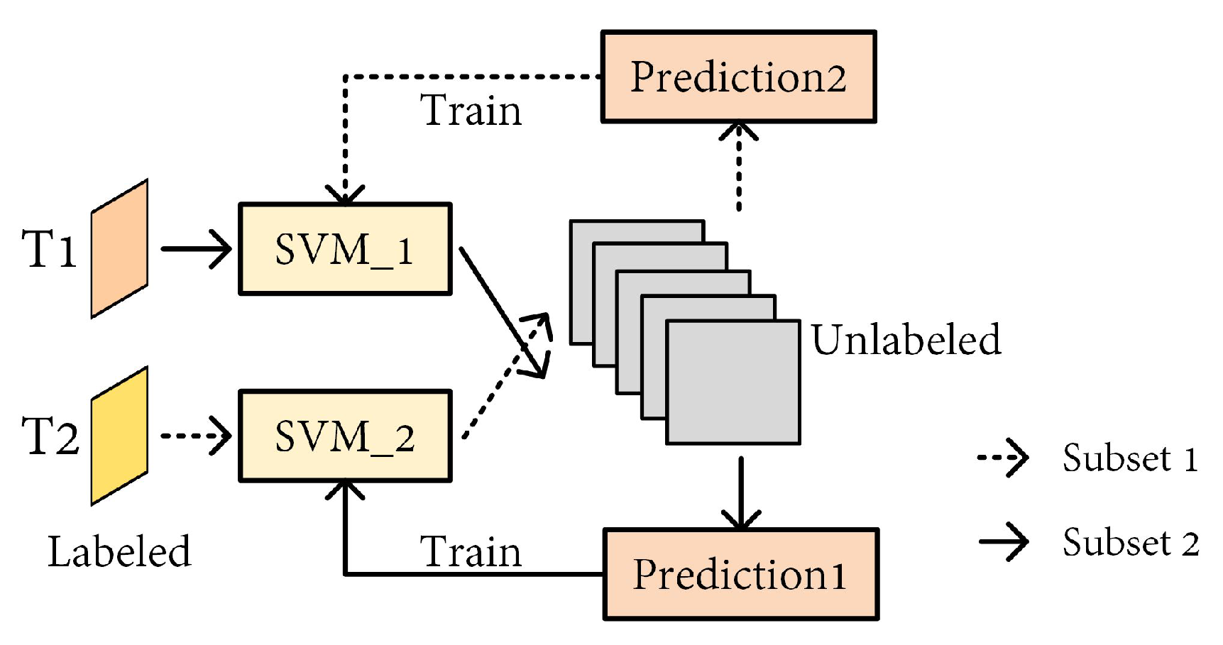
| [95] | Co-EM-SVM | Input: Multi-temporal imagery Label: Visual interpretation Region: Tianshan mountain | Complementary subset co-training, iterative optimization. | F-score: 94.2% |
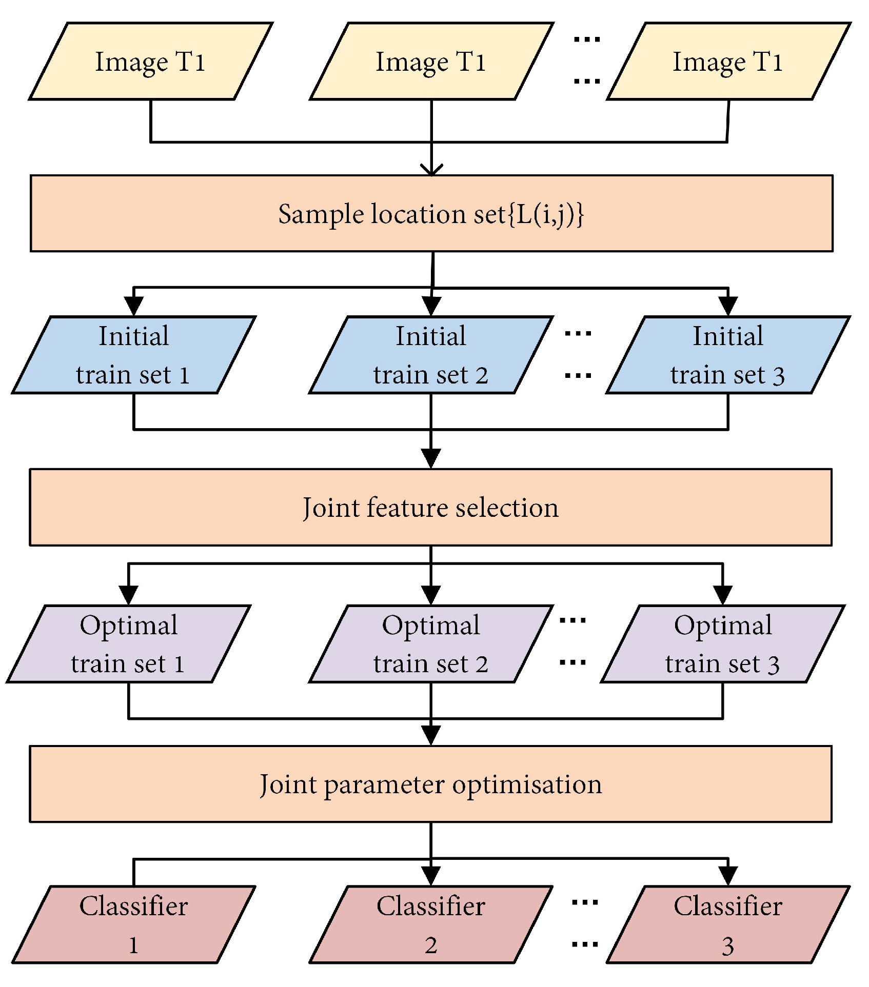
| [96] | SVM | Input: Multi-temporal imagery Label: Not mentioned Region: Tianshan mountain | Joint feature selection and parameter optimization. | Accuracy: 91–99%, F-score: 95–97% |
| Ref. | Data Source (Input/Label) & Region | Feature | Contribution | Result |
|---|---|---|---|---|
| [99] | Input: RADARSAT-2 (C-band, Quad-Pol) Label: Station measurements Region: Dongkemadi glacier | BC | Applying terrain correction to the backscattering coefficient. | Accuracy: 70.75% |
| [98] | Input: RADARSAT-2 Label: Station measurements Region: Dongkemadi glacier | BC; Pauli; H/A/ | Demonstrating the superiority of H/A/ decomposition features over traditional backscattering coefficients and Pauli decomposition. | Accuracy: BC: 85.19%, Pauli: 88.69%, H/A/: 91.10% |
| [100] | Input: RADARSAT-2 Label: Station measurements Region: Ortles-Cevedale massif | BC; Cloude–Pottier; Touzi | Analyzing the effects of terrain correction on backscattering and polarimetric SAR features, as well as the advantages of full polarimetric data over dual-polarization data. | Accuracy: Fully-pol: 93.5%, Dual-pol: 85.7% |
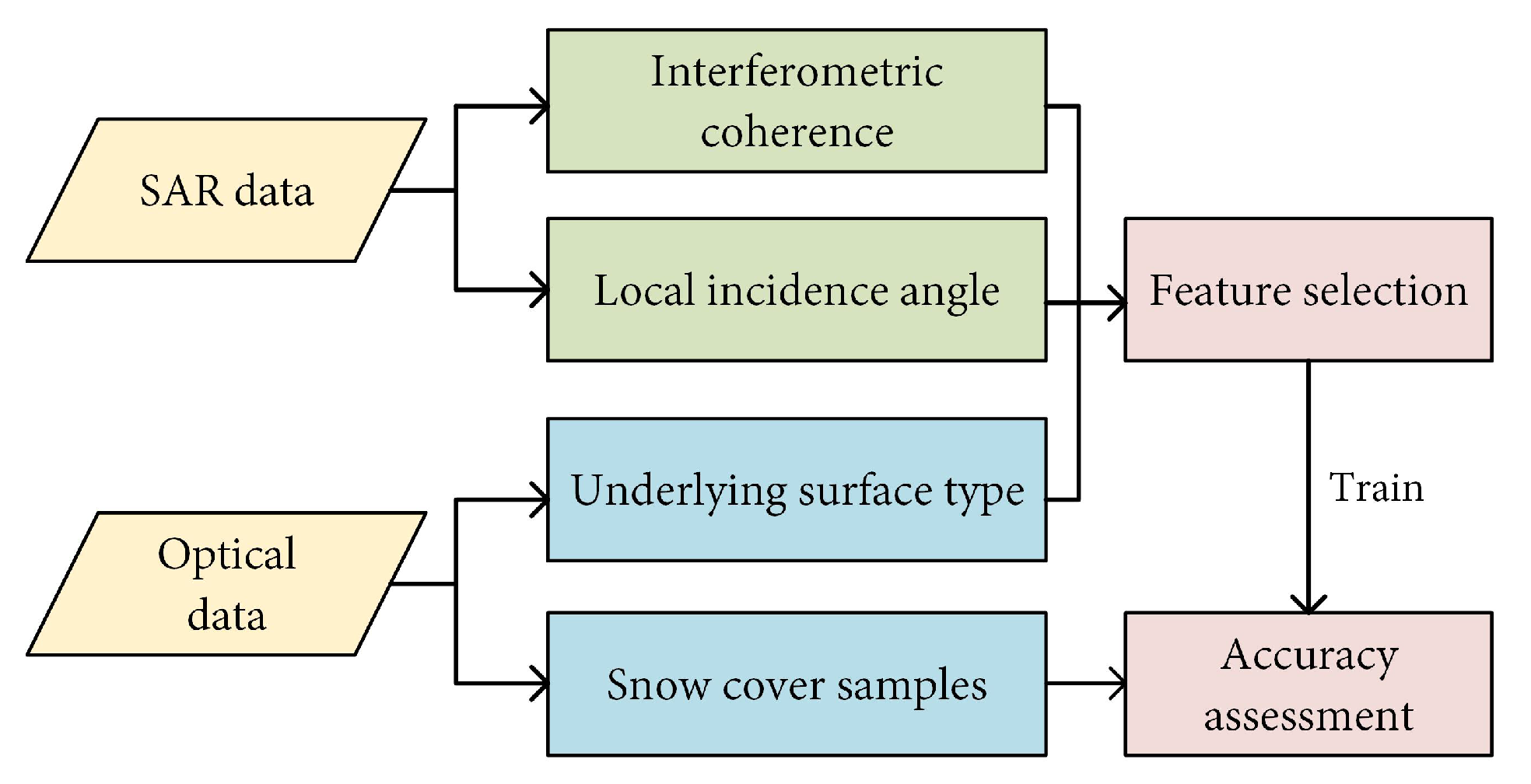
| [104] | Input: Sentinel-1 (C-band, Dual-Pol) Label: Snow_cci Region: Global | BC; InSAR coherence; H/A/; topographical parameters; land cover | Effectively identifies snow cover, distinguishing between dry and wet snow, but has limited generalization capability. | Accuracy: In Mountain: >75%, Without forest: >80% |
| [102] | Input: Sentinel-1 Label: Station measurements Region: Northern Xinjiang | BC; H/ | Optimization of SVM classification results by MRF model. | Accuracy: 84.5% |
| [101] | Input: SCATSAT-1 (Ku-band, Dual-Pol) Label: MOD10A2 Region: Western Himalayas | BC | Demonstrating the potential of Ku series data in snow identification. | Accuracy: 72.07–85.71% |
| Ref. | Data Source | Methods | Results |
|---|---|---|---|
| [110] | SSM/I BT dataset; CMSO; GSOD; | BP-net | Accuracy: >82% Kappa: > 0.715 |
| [111] | EASE-Grid | RF | RMSE: 18.9∼22.1% |
| [112] | EASE-Grid | RF | RMSE = 0.204, R = 0.728, MAE = 0.158 |
| Ref. | Data Source (Input/Label) & Region | Method | Contribution | Result |
|---|---|---|---|---|
| [17] | Input: RadarSat-2 + GF1 Label: Field measurements Region: Tianshan mountain | SVM | Feature fusion between optical and SAR; LVC and HVC. | Accuracy: LVC: 83.8%, HVC: 77.5% |
| [113] | Input: RadarSat-2 + GF1 Label: Field measurements Region: Tianshan mountain | SVM | Differentiation between wet snow and dry snow. | Accuracy: 90.3% |
| [114] | Input: MODIS, Sentinel-1, PROBA-V Label: GlobSnow Region: Global | RF | Differentiation between wet and dry snow; Introduction of PROBA-V. | Accuracy: >90% |
| [115] | Input: MODIS + Sentinel-1 Label: Field measurements Region: Tianshan mountain | PCA-SVM | Object-based principle component analysis. | Accuracy: 77.2% |
| Method | Time | Attention Style | Source |
|---|---|---|---|
| SeNet | 2017 | Channel | [131] |
| CBAM | 2018 | Hybrid | [132] |
| GSoPnet | 2018 | Channel | [133] |
| scSE | 2018 | Hybrid | [134] |
| GENet | 2018 | Spatial | [135] |
| non-local | 2018 | Spatial | [136] |
| SRM | 2019 | Channel | [137] |
| RGA | 2019 | Hybrid | [138] |
| EMANet | 2019 | Spatial | [139] |
| SASA | 2019 | Spatial | [140] |
| ECA-Net | 2020 | Channel | [141] |
| GCT | 2020 | Channel | [142] |
| Triplenet | 2020 | Hybrid | [143] |
| SCNet | 2020 | Hybrid | [144] |
| CCNet | 2020 | Spatial | [145] |
| FcaNet | 2021 | Channel | [146] |
| CoordAttention | 2021 | Hybrid | [147] |
| Ref. | Data Source | Method | Contribution | Result |
|---|---|---|---|---|
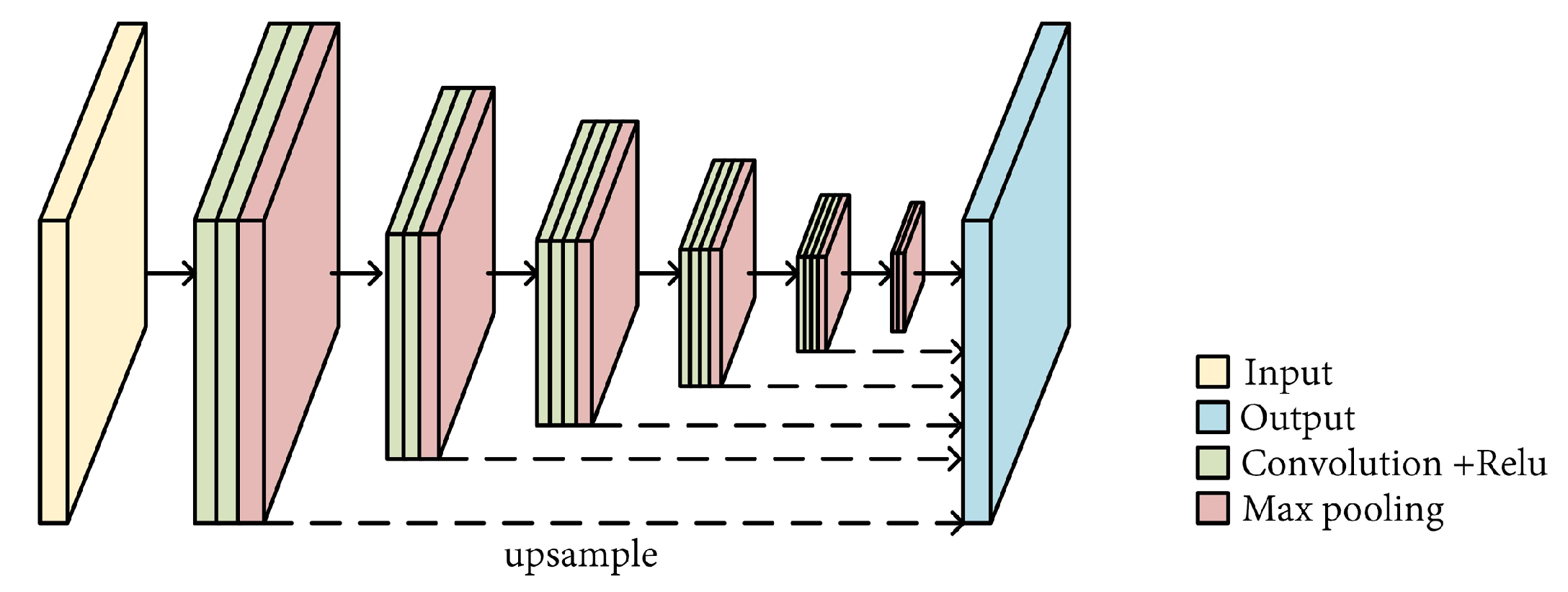
| [120] | GF1 | VGG + Upsample layer | First use of CNN for snow recognition. | MIoU: ENVI 60.8%, FCN 78.6%, ref. [120] 90.6% |
| [121] | HJ-1A/1B | M-ResNet | Improved residual network; Multidimensional input. | Acc: SVM 55.2%, RF 76.4%, CNN 84.2%, M-ResNet 90.3% |
| [25] | TH-1 | ResNet-50 + ASPP | Atrous spatial pyramid pooling. | MIoU: Xception 76.9%, ResNet-50 80.5%, ref. [25] 81.1% |
| [27] | GF-1 | DeepLabV3+ + CRF | Optimization of results by CRF. | MIoU: DeepLabV3+ 81.6%, +CRF 83.6% |
| [125] | ZY-3 | ResNet-50 + CBAM | Channel and spatial attention module. | MIoU: PSPNet 85.1%, DeepLabV3+ 88.9%, ref. [125] 89.2% |
| [126] | GF-2 + HJ-1A | Mod-ResNet-50 + CBAM | ResNet-50 as feature extraction for UNet3+. | MIoU: ResNet-50 78.7%, ref. [126] 81.7% |
| [130] | HJ-1A/1B | ResNet-18 + SENet | Lightweight; Channel attention module. | Acc: ResNet-18 89.8%, ref. [130] 95.0% |
| [148] | HRC_WHU | ResNet-50 + EdgeViT | EdgeViT for global feature; Lightweight. | MIoU: 91.6%, Acc: 95.8% |
Disclaimer/Publisher’s Note: The statements, opinions and data contained in all publications are solely those of the individual author(s) and contributor(s) and not of MDPI and/or the editor(s). MDPI and/or the editor(s) disclaim responsibility for any injury to people or property resulting from any ideas, methods, instructions or products referred to in the content. |
© 2026 by the authors. Licensee MDPI, Basel, Switzerland. This article is an open access article distributed under the terms and conditions of the Creative Commons Attribution (CC BY) license.
Share and Cite
Ma, K.; Zhang, Z.; Hu, K.; Wang, N.; Liu, Q.; Guo, T. Review of Snow Identification Algorithms: From Traditional Machine Learning to Semantic Methods. Remote Sens. 2026, 18, 1067. https://doi.org/10.3390/rs18071067
Ma K, Zhang Z, Hu K, Wang N, Liu Q, Guo T. Review of Snow Identification Algorithms: From Traditional Machine Learning to Semantic Methods. Remote Sensing. 2026; 18(7):1067. https://doi.org/10.3390/rs18071067
Chicago/Turabian StyleMa, Keyu, Zhixuan Zhang, Kai Hu, Ning Wang, Qi Liu, and Tengyue Guo. 2026. "Review of Snow Identification Algorithms: From Traditional Machine Learning to Semantic Methods" Remote Sensing 18, no. 7: 1067. https://doi.org/10.3390/rs18071067
APA StyleMa, K., Zhang, Z., Hu, K., Wang, N., Liu, Q., & Guo, T. (2026). Review of Snow Identification Algorithms: From Traditional Machine Learning to Semantic Methods. Remote Sensing, 18(7), 1067. https://doi.org/10.3390/rs18071067